In a news release this afternoon, Pacific Northwest LNG announced that the company has given a positive, but conditional, Final Investment Decision, to build an LNG facility on the environmentally sensitive Lelu Island at Port Edward. BC.
Pacific NorthWest LNG (PNW LNG) announced today that the required technical and commercial components of the project have been satisfied. Consequently, PNW LNG has resolved to move forward with a positive Final Investment Decision, subject to two conditions.
The Final Investment Decision will be confirmed by the partners of PNW LNG once two outstanding foundational conditions have been resolved. The first condition is approval of the Project Development Agreement by the Legislative Assembly of British Columbia, and the second is a positive regulatory decision on Pacific NorthWest LNG’s environmental assessment by the Government of Canada.
“In parallel with work to support the Final Investment Decision, Pacific NorthWest LNG will continue constructive engagement with area First Nations, local communities, stakeholders and regulators,” said Michael Culbert, President of Pacific NorthWest LNG. “The integrated project is poised to create thousands of construction and operational careers in the midst of the current energy sector slowdown.”
Progress Energy Canada and the North Montney Joint Venture partners will continue to invest in its North Montney natural gas resources. The investment to date has proved and probable natural gas reserves of over 20 trillion cubic feet (tcf) with $2 billion-plus invested annually, representing approximately 4,000 sustainable jobs in northeast British Columbia.
“A Final Investment Decision is a crucial step to ensure that the project stays on track to service contracted LNG customers,” Culbert continued. “Pacific NorthWest LNG is poised to make a substantial investment that will benefit Canada for generations to come.”
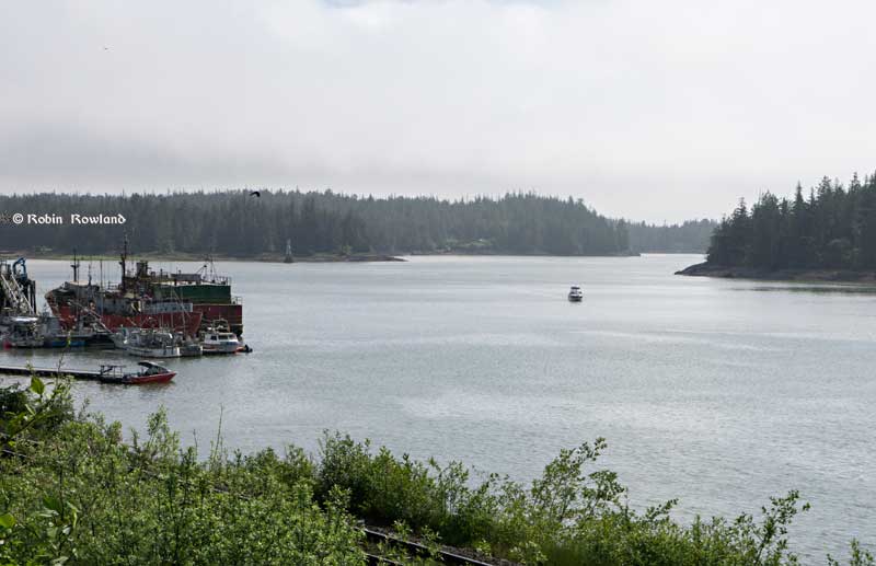
Lelu Island, the flat area in the left of the image, across from the harbour at Port Edward is the potential site of the Petronas Pacific Northwest LNG project. (Robin Rowland/Northwest Coast Energy News)
Although Pacific Northwest LNG is first off the mark with a positive, if conditional, Final Investment Decision, putting a shovel in the ground is not guaranteed. Of all the proposed liquified natural gas projects for northwestern BC, the location on Lelu Island, right at the mouth of the Skeena River, is probably the most environmentally sensitive. Even if the Canadian Environmental Assessment Agency does give its approval, probably with a long list of conditions, it is highly likely the decision will be challenged in court by First Nations and environmental groups.
The environmental process was put on hold in early June after the agency asked Pacific Northwest to provide more information about building the terminal. The island sits near Flora Bank, where young salmon shelter in eel grass after coming down the Skeena, taking time to grow before venturing out into the Pacific. Flora Bank has been called the “nursery” for one of the world’s most important salmon runs.
The fact that Pacific Northwest LNG has to supply more studies means that any final environmental assessment decision will come after October’s federal election.
After initial proposals to dredge the area where met with loud and sustained opposition, Pacific Northwest proposed a suspension bridge and trestle which means the LNG tankers would tie up well off the island in Chatham Sound.
Lelu Island is on the traditional territory of the Lax Kw’alaams First Nation. Members of the First Nation recently voted overwhelmingly against accepting a billion dollars over the life of the project from Pacific Northwest.
Pacific NorthWest LNG filed a report, prepared by engineering and environmental company Stantec Inc., that said there would little or no environmental impact impact from building the $11.4-billion LNG terminal. Stantec’s report, however, is unlikely to reassure many people in the northwest because of Stantec’s close to ties to the energy industry. Stantec did major studies for the controversial Enbridge Northern Gateway project, studies that were challenged by other environmental studies opposing that pipeline project.
Petronas holds 62-per-cent of Pacific NorthWest LNG.
Partners are China’s Sinopec, which holds 10 per cent, Indian Oil Corp. Ltd. which holds 10 per cent, Japan Petroleum Exploration, 10 per cent, China Huadian Corp., 5 per cent and Petroleum Brunei, 3 per cent.
As well some First Nations and environmental groups in the northwest of British Columbia, in the northeast, Blueberry River First Nations who live in the North Montey natural gas region have said they are worried about increased drilling in their traditional territory are concerned about increased drilling by Progress Energy for natural gas within their traditional territory.
The Blueberry River group says it plans request judicial review of the B.C. Natural Gas Development Ministry’s decision to sign the 23-year royalty agreement for the region.
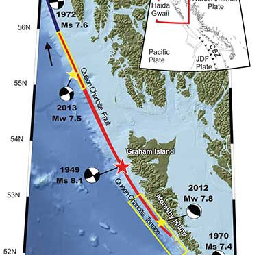
A “devastating megathrust earthquake” could hit Haida Gwaii sometime in the future, according to Canadian and US studies carried out after the magnitude 7.8 earthquake off Haida Gwaii on Oct. 27, 2012 and the 7.5 magnitude quake off Craig, Alaska, a few weeks later on Jan. 5, 2013.
The 2004 Indian Ocean earthquake and the 2011 Tōhoku earthquake in Japan, both accompanied by major tsunamis are recent examples of “great” (higher than magnitude 8.0) megathrust earthquakes. Most of the concern on the west coast has been the likelihood of a megathrust earthquake on the Cascadia Fault on the Juan de Fuca plate that stretches from northern California to the middle of Vancouver Island.
The 2012 Haida Gwaii main shock was the second largest seismic event in Canada since the establishment of a modern seismograph network. The first was the 1949 Haida Gwaii/Queen Charlotte earthquake with a magnitude of 8.1 That 1949 Haida Gwaii earthquake was a strike-slip event, where the plates move side-to-side, similar to the 1906 San Francisco earthquake and other quakes on the San Andreas Fault in California.
The 2012 Haida Gwaii earthquake is characterized in the studies as a “mini-megathrust” event, where part of the crust is pushed upward, meaning that a larger megathrust could have much more destructive consequences from both the earthquake and a possible tsunami.
A diagram of the situation off Haida Gwaii that triggered the October 2012 “mini megathrust” earthquake seen at the lower centre, while the 1949 slip strike earthquake is seen at the top. (Bulletin of the Seismological Society of America)
Complex system of faults
The new studies show that the Pacific and North America plate boundary off the coast of British Columbia and southeastern Alaska creates a system of faults capable of producing very large earthquakes. The scientists conclude that while the two earthquakes in 2012 and 2013 released strain built up over years on the tectonic plates, those events did not release strain along the Queen Charlotte Fault off the west coast of Haida Gwaii. That means the fault remains the likely source of a future large earthquake.
Map showing the pattern of earthquakes along the Queen Charlotte Fairweather Fault system and the location of the Queen Charlotte Terrace. (Bulletin of the Seismological Society of America)
A special issue of the Bulletin of the Seismological Society of America (BSSA), released Monday, April 6, 2015, contains 19 scientific and technical papers, outlining the results of the work carried out over the past two years.
The team estimated the rupture dimension of the 2012 Haida Gwaii earthquake to be about 120 kilometres long at a depth of about 30 kilometres.
The Craig earthquake ruptured the Queen Charlotte fault over a distance of more than 100 kilometres and at a depth of about 20 kilometres.
The two areas are joined in what is called the Queen Charlotte Fairweather Fault System. To the south the Queen Charlotte Fault also interacts with the Juan de Fuca plate that stretches from Vancouver Island to northern California.
“The study of these two quakes revealed rich details about the interaction between the Pacific and North America Plates, advancing our understanding of the seismic hazard for the region,” said Thomas James, research scientist at Geological Survey of Canada.
Two faults off Haida Gwaii
The studies conclude that the interaction between the plates off Haida Gwaii is much more complex than previously believed. Before the 2012 earthquake, the Queen Charlotte Fault, a strike-slip fault similar to the San Andreas Fault in California, was believed to be the dominating tectonic structure in the area. The 2012 tremor confirmed the existence of a previously suspected thrust fault beneath what is called the “Queen Charlotte Terrace,” to the west of the Queen Charlotte Fault, where the Pacific plate is sliding at a low angle below the North American plate.
The Queen Charlotte Terrace, which is about a kilometre below the surface of the ocean, is built up of layers of sediment, several kilometres thick, scraped off the oceanic plate as it subducts under the North American plate. It may also include some fragments of oceanic crust. For most of the terrace, it is “present as a clearly defined linear feature,” but the study adds: “north of about 53.5° N, a complex pattern of ridges and valleys appears.”
The earthquake was “essentially a mini-megathrust earthquake along the dipping plate interface of a subduction system,” one of the scientific papers says. The epicenter of the Haida Gwaii main shock was located about five kilometres landward (northeast) of the Queen Charlotte Fault. That probably means that the rupture was near the bottom of the locked plates, where the plate motion’s side to side movement is also thrusting downward. Significant aftershocks appeared to cluster on the periphery of the main rupture zone with most of the aftershocks occurring seaward to the west.
The scientists used GPS observations of crustal motion to locate the earthquake’s rupture offshore to the west of Haida Gwaii.
The situation off Haida Gwaii is complex because while the Pacific plate is converging with the North American plate at a rate of 15 to 20 millimetres a year, at the same time the two plates are slipping by each other toward the north northwest at angle of about 20 degrees at a rate of about 50 millimetres a year.
Honn Kao, a seismologist with the Geological Survey of Canada said, “This was an event the thrust interface of the plate boundary system, confirming that there is a subduction system in the Haida Gwaii area.
“The implication of a confirmed subduction zone is that in addition to the Queen Charlotte Fault, we now have another source which can produce devastating megathrust earthquakes in the area,” said Kao.
The study of the Haida Gwaii tremor looked at the causative faults, the rupture processes and depths of the main shock and sequence of strong aftershocks.
The Haida Gwaii earthquake generated a significant tsunami that left deposits indicating run-up exceeding 3 metres (maximum 13 metres) in a number of bays and inlets along about 230 kilometres along the west coast of Haida Gwaii. In Hawaii, a 0.8 metre wave was measured on a tide gauge.
In Queen Charlotte City perceptible shaking lasted for one and half to two minutes, with very strong shaking for about 30 seconds. The earthquake was felt as far away as Yukon Territory, Alberta, and Montana.
The study says “Damage was limited, in part owing to the sparse population, but also because of the seismic resistance of the generally low rise, wood-frame buildings on the islands. Felt intensities were at expected values close to the source zone, but regional intensities were smaller than predicted.”
The Haida Gwaii rupture also shook southeastern Alaska. The northwest direction of ground motion then may have influenced the timing of the Craig earthquake a few weeks later in January 2013. That earthquake occurred farther north in southeast Alaska, where relative plate motion is nearly parallel to the Queen Charlotte fault.
Aftershocks
.
Map showing the pattern of aftershocks following the October 2012 Haida Gwaii earthquake. (Bulletin of the Seismological Society of America)
The Haida Gwaii aftershocks clustered around the periphery of the rupture zone, both on the seaward and landward side of the plate boundary and reflected what the study calls “normal faulting behavior–caused by the bending, extending or stretching of rock– rather than the thrust faulting of the main shock.” The pattern of aftershocks is similar to those observed after the 2011 Japanese megathrust earthquake.
“Our observations of normal faulting imply that the main shock of the Haida Gwaii earthquake dramatically altered the stress field in the rupture zone, especially in a neighboring region,” Kao said.
The distribution of aftershocks occurred to the north of a previously identified seismic gap where large earthquakes have not occurred in historic times. The gap is located to the south of the where 1949 magnitude 8.1 Queen Charlotte earthquake ruptured.
Though the Haida Gwaii earthquake may have activated some part of the Queen Charlotte Fault, Kao said, it was limited and did not relieve stress along the seismic gap.
The study concludes:
The Haida Gwaii event confirmed substantial seismic and tsunami hazard from large thrust events on the plate margin along the southern Queen Charlotte fault. It occurred where relatively young oceanic lithosphere under thrusts North America and in some ways is an analog for the much larger megathrust earthquakes known to occur on the Cascadia subduction zone to the south, where the young Juan de Fuca plate and other small plates subduct beneath North America. The Haida Gwaii earthquake had a complex pattern of main shock rupture and aftershocks and a large tsunami.
Further study needed
The Geological Survey of Canada plans further studies to understand the formations off Haida Gwaii.
One question to ask is if there are any records of major earthquake events in the past history of Haida Gwaii. The study notes that the impact of the tsunami was relatively minor “in this region with steep rocky coastlines.” That means there are limited sources of coastal sediments that can be checked for past events. It adds: “Low-elevation lakes, ponds, and bogs may offer the best opportunities for paleotsunami studies” warning that large earthquakes in the past that produced tsunamis may have left little evidence in the “paleoseismic record of Haida Gwaii and similar settings worldwide.”
Megathrust earthquakes occur at subduction zones at destructive plate boundaries where one tectonic plate is subducted (forced underneath) by another. These interplate earthquakes are the planet’s most powerful, with moment magnitudes that can exceed 9.0. Since 1900, all earthquakes of magnitude 9.0 or greater have been megathrust earthquakes. During the rupture, one side of the fault is pushed upwards relative to the other, and it is this type of movement that is known as thrust. The displacement of the ocean in a thrust can trigger a tsunami.
Transform fault
A transform fault is one where the motion is predominantly horizontal. Those faults end abruptly and are connected on both ends to other faults, ridges, or subduction zones. The best-known (and most destructive) are those on land at the margins of tectonic plates. Transform faults are the only type of strike-slip faults at plate boundaries show strike-slip or side-to-side in movement.
Queen Charlotte Terrace
The Queen Charlotte Terrace is a 25 kilometre wide zone of built up marine sediment immediately west of the active Queen Charlotte fault. The crust is about 12 kilometres thick at the terrace. On Haida Gwaii, the earth’s crust is 18 kilometres thick at the eastern edge. On the BC mainland the crust is in excess of 30 kilometres thick.
Historic earthquakes.
The 1949 Haida Gwaii quake was one of the largest in the recorded history of North America.
The largest known earthquake along the coast was the megathrust event on the Cascadia fault on January 26, 1700 where the Juan de Fuca plate ruptured for about 1,000 kilometres along from what is now northern California to Vancouver Island, estimated at magnitude 9.0. The dating is based on a tsunami that hit Japan that had no associated local earthquake as well studies of tree rings from the remains of trees downed in the tsunami.
Three studies of the geology of Douglas Channel are near completion and publication, according to Natural Resources Canada. That news comes as studies, released today, warn of a major megathrust earthquake on the fault west of Haida Gwaii.
Northwest Coast Energy News asked the Geological Survey of Canada if there were any recent updates available after the agency said that a survey had located a “possible fault” on Hawkesbury Island during studies for the Enbridge Northern Gateway Joint Review Panel.
Natural Resources Canada responded with a statement: “NRCan continues to conduct research studies in the area, including study of possible faults. Three scientific expeditions have been completed on board Coast Guard research ships. The first two reports are in the final stages of editing, and will be published in the coming months. The third expedition was just completed; therefore the third report will be available later.”
More recently there were slope failures nearer to Kitimat. The first slope failure occurred on October 17, 1974, triggering a 2.4 metre tsunami at low tide. Then on April 27, 1975 there was a second slope failure near low tide on the northeast slope of the Kitimat Arm that generated an 8.2 metre tsunami. The 1975 tsunami destroyed the Northland Navigation dock near Kitimat and damaged the Haisla First Nation docks at Kitamaat Village.
Thomas James, of the Geological Survey told Northwest Coast Energy news about the team’s finding on the Haida Gwaii earthquake: “The studies focused on the Haida Gwaii and Craig earthquakes which happened at the Pacific and North American plate boundary, west of Haida Gwaii, so east of Haida Gwaii there’s no comparable plate boundaries that gives rise of historic sieismisticity.”
As well as the fact that recent studies say the mainland margin coastal zone has had very little historical seismicity, it adds no currently active faults have been identified. A study ten years ago identified some very ancient faults which have not been active since the Eocene, about 33 to 56 million years ago.
GPS studies show that in northwestern British Columbia coastal block is moving northeast at the rate of just 5 millimetres a year.
Kitimat Emergency Coordinator Bob McLeod at the earthquake postmortem Oct. 29, 2012 (Robin Rowland/Northwest Coast Energy News)
Studies of the October 2012 magnitude 7.8 Haida Gwaii earthquake show that the region is vulnerable to a “major megathrust” earthquake along a newly confirmed fault line west of the islands.
That earthquake was felt in Kitimat and Kitamaat Village and a tsunami warning was issued within a few minutes.
So have the District of Kitimat, the Haisla Nation Council or Rio Tinto Alcan changed or upgrading their earthquake and tsunami plans in the past couple of years?
Bob McLeod, who recently retired as the District of Kitimat’s emergency coordinator, told Northwest Coast Energy News: “I think we’ve done quite a bit. One of the biggest issues in the first one was trying to get information out. We’ve come a long way on that. Whether you reach everyone or not, that’s another thing, because you never reach everybody. One of the critical things to me is getting the information out so you avoid all this Facebook, Twitter speculating and rumour. The communications aspect has improved a hundred fold.
“We did more work on the mapping and planning. Over the course of the last year, there were a lot of meetings with industry and various stakeholders, discussing emergency preparedness in general but touching on some of these other things as well.
“One of the things we did was to try to set up some shelter points. We have an agreement with the Baptist Church, the Catholic Church and the Seventh Day Adventists. They’re strategically located and could be gathering points for the various neighborhoods if necessary.
“We’ve also done quite a lot of work on Riverlodge as a group lodging centre, thinking in terms of an earthquake where there may be damage and you have to move people.
“We did look at the evacuation planning and we’ve had a couple of exercises involving that, looking strategically about how can you move people from certain neighborhoods, asking which neighborhoods would be at the most risk if you ended up with a tsunami situation.
As for tsunamis, McLeod said, “From everything we’ve heard and been told, tsunamis in extremely deep water like that is not going to be as dangerous as one in shallower water, but the possibility is still there.
“The thrusts are the killers when it comes to tsunamis, but there is a very good warning system on the tsunamis. We do get very very rapid feedback on the earthquakes.
“The only danger in that regard is if you have a severe earthquake and you have part of a mountain drop into the salt chuck, you’re going to get a massive wave and you’re going to get no warning whatsoever, like the Moon Bay collapse in the seventies.
“The emergency plan is in good shape. We scheduled a number of exercises last year through training programs.
“One of the things I personally push is personal preparedness. I think as a community, we fail greatly at that. That was evident even during the snowstorm. People are not just prepared to look after themselves, it’s unfortunate. You just have to keep chipping away.”
Last week, Northwest Coast Energy News asked Rio Tinto Alcan and the Haisla Nation Council if either could comment on updated earthquake or tsunami response plans. So we have received no answers.
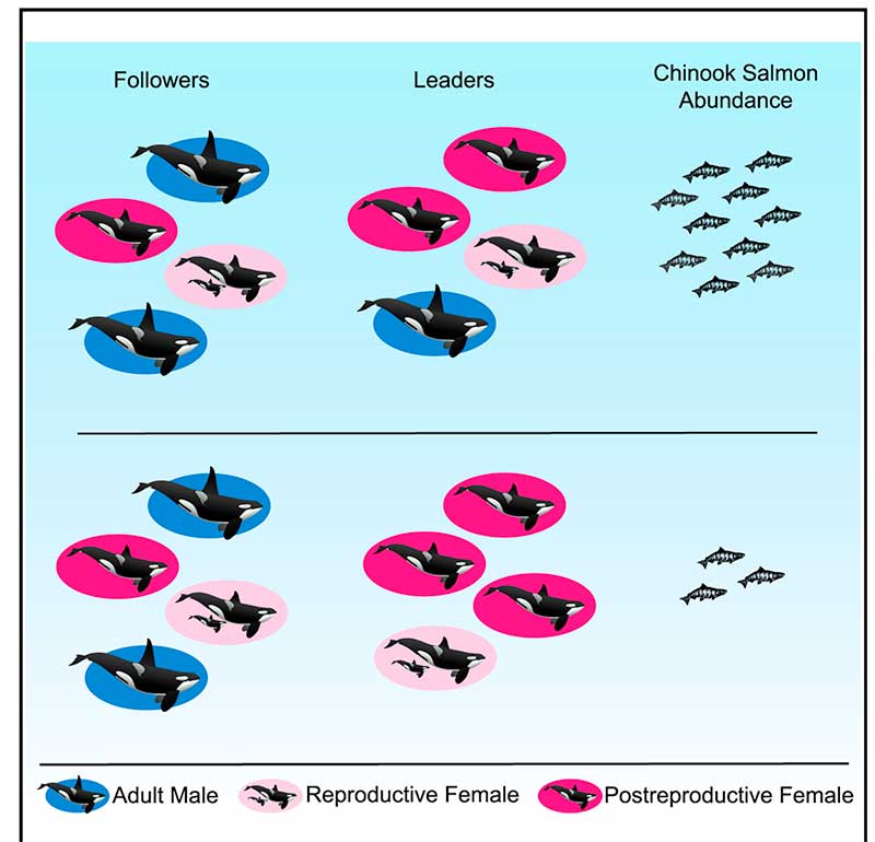
A new study concludes that British Columbia’s southern resident Orca pod is led by “post reproductively aged” females who help it survive during lean years.
According to the study, the older females serve as key leaders, directing younger members of the pod, and especially their own sons, to the best spots for landing tasty meals of salmon, helping their kin to survive. This leadership role takes on special significance in difficult years when salmon are harder to come by.
The researchers say the discovery offers the first evidence that a benefit of prolonged life after reproduction is that post-reproductive individuals act as repositories of ecological knowledge.
There are only three species on Earth where females go through menopause, human beings, killer whales and pilot whales.
Older females lead Orca pods in hard times. (Current Biology)
“Menopause is one of nature’s great mysteries,” says Lauren Brent of the University of Exeter in the United Kingdom. “Our study is the first to demonstrate that the value gained from the wisdom of elders may be one reason female killer whales continue to live long after they have stopped reproducing.”
The scientists say in their paper this also provides insights into why human women continue to live long after they can no longer have children.
Leadership by these females is especially prominent in difficult years when salmon abundance is low.
Female killer whales typically become mothers between the ages of 12 and 40, but they can live for more than 90 years. By comparison, male Orcas rarely make it past 50.
Resident pods feed mostly on Chinook salmon. Chinook make up than 90 per cent of their diet during the summer. The abundance of salmon fluctuates due to fishing by humans and weather changes such as El Nino and climate change. The study says that individual killer whales with information on where and when to find salmon provide other group members with considerable benefits.
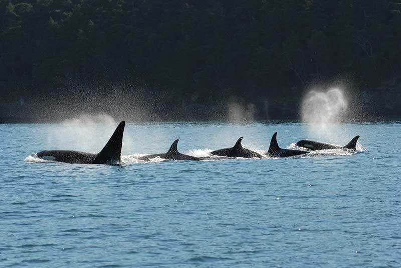
To find out who were the leaders of the Southern Resident pod, the team analyzed 751 hours of video footage taken over 35 years of as many as 102 Southern resident killer whales in the coastal waters of British Columbia and Washington engaged in directional travel , collected during nine summer salmon migrations. The scientists also used multigenerational demographic records have been recorded for the Southern resident killer whales since 1976, allowing them to know the family relationships of the Orcas.
A killer whale pod swims in tight configuration. (David Ellifrit, Center for Whale Research)
The study found that in any given year, adult females were more likely to lead the pod’s group movement compared to adult males They concluded that Orca matriarchs over the age of 35 years “the mean age at last reproduction for Southern resident females that lived past the age of peak adult female mortality” were more likely to lead the pod “compared to reproductively aged females.”
The scientists then compared fisheries data on Chinook salmon abundance to whale behavior. It showed that “post-reproductively aged females were more likely to lead group movement in years when salmon abundance was low.”
The scientists concluded that shows that prolonged life after the reproductive years allows the “individuals act as repositories of ecological knowledge.”
In the case of Orcas, the post menopausal matriarchs “lead group movement in and around salmon foraging grounds, and this is exaggerated when salmon are in low supply and the selective pressure to locate food is at its highest.”
The researchers also found that females are more likely to lead their sons compared to their daughters.
Daniel Franks of the University of York explained: “Killer whale mothers direct more help toward sons than daughters because sons offer greater potential benefits for her to pass on her genes. Sons have higher reproductive potential and they mate outside the group, thus their offspring are born into another group and do not compete for resources within the mother’s matriline. Consistent with this, we find that males follow their mothers more closely than daughters.”
So how does the study of Orca elders apply to human beings?
“In humans, it has been suggested that menopause is simply an artefact of modern medicine and improved living conditions,” said Darren Croft of the University of Exeter. “However, mounting evidence suggests that menopause in humans is adaptive. In hunter-gatherers, one way that menopausal women help their relatives, and thus increase the transmission of their own genes, is by sharing food. Menopausal women may have also shared another key commodity – information.”
Recent studies show that living beyond the age of 60 is much more comon in hunter-gatherer cultures than previsouly believed.
So the study concludes that in humans:
In hunter-gatherers, one way that menopausal women help their relatives, and thus improve their own inclusive fitness, is by sharing food.
Menopausal women may also share another key commodity—information. Humans were preliterate for almost the entirety of our evolutionary history and information was necessarily stored in individuals. The oldest and most experienced individuals were those most likely to know where and when to find food, particularly during dangerous and infrequent conditions such as drought.
As for Orcas:
Wild resident killer whales do not have the benefits of medical care, but, similar to humans, females can live for more than 40 years after they have ceased reproducing. An individual resident killer whale’s ability to find salmon is crucial to their fitness; in years with low salmon abundance, resident killer whales are more likely to die and less likely to reproduce.
Our finding that postreproductively aged female killer whales are especially likely to lead group movement in years with low salmon abundance suggests that the ecological knowledge of elders helps explain why females of this species live long after they have stopped reproducing. Postreproductive female killer whales may provide other knowledge to their relatives. For example, postreproductive members of this socially complex species may have greater social knowledge that could help kin navigate social interactions.
In some other species, like African elephants, survival is enhanced in the presence of older female relatives, who are more capable of assessing social and predatory threats.
So the study asks “why is menopause restricted to some toothed whales and humans?”
The scientists believe that for evolution, menopause will only evolve when the benefits for the species outweigh the costs of terminating reproduction.
In humans, resident killer whales, and short-finned pilot whales, when a female usually stays in the immediate location of her family, that means that the benefits she can gain through helping her relatives, increases with age.
Among Southern resident Orcas, neither sex leaves the family pod and “females are born into groups with their mothers and older siblings.”
As the female resident Orca ages, her older relatives who die are replaced by “her own nondispersing sons and daughters.” In ancestral humans, resident killer whales and short-finned pilot whales, the benefits of the elders helping therefore increase with age, which is thought to predispose these three species to menopause
The study notes that Orcas have a number of different “ecotypes” or cultures “which differ in their prey specialization, morphology, and behavior, and which in some cases represent genetically distinct populations.” That means “that not all ecotypes are characterized by the same social structure as resident killer whales” where females leave their birth pod. The say more study is needed to find out if menopause occurs in those Orca pods and what the role of older females is in those pods. The study also did not look at the northern residents who frequently visit Douglas Channel.
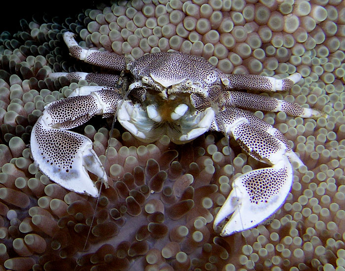
Climate change, which will raise ocean temperatures and more carbon dioxide in the atmosphere which will increase the acidification of the oceans will have the greatest affect on the intertidal zones—and a key indicator species, crabs and similar creatures.
A study by San Fransisco State University published today in the Journal of Experimental Biology used the small (usually 15 millimetre) porcelain crab to simulate the conditions that will come to the intertidal zone and affect other species including the larger dungeness crab. ( According to Wikipedia, porcelain crabs are an example of carcinisation, whereby a non-crab-like animal,in this case a relative of a squat lobster evolves into an animal that resembles a true crab.)
A porcelain crab (Nick Hobgood via Wikipedia)
Studies have shown that as climate changes, coastal ecosystems will be see “have increased extremes of low tide-associated thermal stress and ocean acidification-associated low pH.”
The study by co-author Jonathan Stillman and his colleagues, is the first to explore intertidal zone organisms’ response to combined variation in temperature and pH, which is expected to intensify in the future due to climate change and ocean acidification.
The current and previous studies have shown that during low tide, air temperatures in the intertidal zone can fluctuate dramatically as much as 20 degrees celcius over short periods of time up to six hours. Temperatures can reach extremes when low tides coincide with hot days. Marine intertidal organisms tolerate these natural temperature fluctuations, yet it is known that they are limited in their scope to tolerate future warming.
In the simulation porcelain crabs were placed in a specially built aquarium designed to simulate the natural environment, including tidal changes. At low tide, with the crabs exposed to the air, the researchers varied the temperature to mirror day-to-day changes the crabs currently experience — such as cooler air on a cloudy day and warmer air on a sunny day — as well as conditions expected in the future. At high tide, with the crabs submerged, they adjusted pH levels in the same fashion.
As the temperature rose and pH levels dropped — conditions expected in the future due to climate change — the crabs’ ability to withstand heat increased. But at the same time, researchers found, the crabs’ metabolism decreased. In addition, the combined effect of higher temperatures and lower pH levels was greater than the effect of either of those two factors alone.
“When you combine these things together, they slow down metabolism, which means crabs become sluggish and have less overall energy to do things like growth or reproduction,” Stillman said. “If their whole energy budget is a pie, then in the future the size of the pie is going to be smaller, and a larger percentage of it is going to be taken up by survival and maintenance.”
The study says that although porcelain crabs are not particularly important to humans — they are not fishery crabs such as Dungeness — they are an important food source for coastal fish, birds and other crabs.
The results suggest “there is a potential for adverse long-term ecological consequences for intertidal ectotherms”– that is creatures that depend on the external temperatures to regulate body heat– “exposed to increased extremes in pH and temperature due to reduced energy for behavior and reproduction.”
The porcelain crabs can also be seen as a model for scientists to understand the impacts of climate change and ocean acidification on crustaceans in general, Stillman said. Future studies will look at the impact of varying temperature and pH changes on different species of porcelain crabs, juvenile crabs and crab embryos.
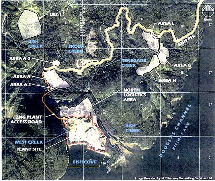
Chevron has applied to the BC Ministry of the Environment for a permit to discharge storm water from the liquified natural gas construction site at Bish Cove and along the shore of Douglas Channel.
The construction site is currently operating on a Waste Water Discharge Approval that expires on Oct. 31.
Map showing construction areas at the Kitimat LNG site at Bish Cove likely to discharge storm water into the Douglas Channel. (Chevron/ McElhanney Consulting)
The application sets new objectives that “will be protective of the receiving environment.” Various construction areas will discharge storm water (likely due to clearing of the bush cover) from areas at Bish Cove itself and the Bish Creek watershed “including the following watercourses and associated tributaries: Bish Creek, West Creek, Skoda Creek and Renegade Creek.”
The application says that the “maximum rate of effluent discharged from this project and support areas will vary based upon seasons and weather.” Areas and amounts of water may change as the construction proceeds. “The characteristics of the stormwater runoff will be water produced from precipitation, including snowmelt that contains suspended sediment from earthworks and construction.” The application adds, “The types of treatment to be applied to the discharges are: erosion prevention and sedimentation control management practices and devices which may include sedimentation ponds, oil water separators, pH adjustment, flocculent addition and sand filtration.
The public and concerned individuals or groups can provide “relevant information” to the Regional Manager, Environmental Protection, #325-1011 Fourth Ave, Prince George BC V2L 3H9 until September 20, 2014 or call Marc Douglas at 844-800-0900.
The United States says acidification of the oceans means there is an already growing risk to the northwest coast fishery, including crab and salmon, according to studies released by the National Oceanic and Atmospheric Administration.
As more carbon dioxide is released into the atmosphere and absorbed by the oceans, the water is becoming more acidic and that affects many species, especially shellfish, dissolving the shells.
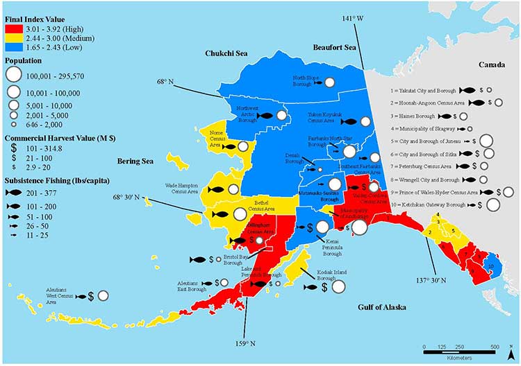
A NOAA study released today of environmental and economic risks to the Alaska fishery says:
Many of Alaska’s nutritionally and economically valuable marine fisheries are located in waters that are already experiencing ocean acidification, and will see more in the near future…. Communities in southeast and southwest Alaska face the highest risk from ocean acidification because they rely heavily on fisheries that are expected to be most affected by ocean acidification…
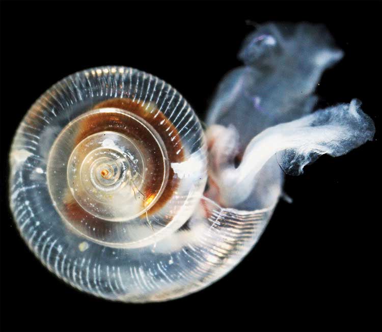
An earlier NOAA study, released in April, identified a long term threat to the salmon fishery as small ocean snails called pteropods which are a prime food source for pink salmon are already being affected by the acidification of the ocean.
This photograph from NOAA of a pteropod, important in the ocean diet of pink salmon, shows the first evidence of marine snails from the natural environment along the U.S. West Coast with signs that shells are dissolving. (NOAA)
NOAA says:
The term “ocean acidification” describes the process of ocean water becoming more acidic as a result of absorbing nearly a third of the carbon dioxide released into the atmosphere from human sources. This change in ocean chemistry is affecting marine life, particularly the ability of shellfish, corals and small creatures in the early stages of the food chain to build skeletons or shells.
Today’s NOAA study is the first published research by the Synthesis of Arctic Research (SOAR) program, which is supported by an US inter-agency agreement between NOAA’s Office of Oceanic and Atmospheric Research and the Bureau of Ocean Energy Management (BOEM) Alaska Region.
Des Nobles, President of Local #37 Fish [UFAWU-UNIFOR] told Northwest Coast Energy News that the fisheries union and other fisheries groups in Prince Rupert have asked both the Canadian federal and the BC provincial governments for action on ocean acidification. Nobles says so far those requests have been ignored,
Threat to crabs
The studies show that red king crab and tanner crab grow more slowly and don’t survive as well in more acidic waters. Alaska’s coastal waters are particularly vulnerable to ocean acidification because of cold water that can absorb more carbon dioxide and unique ocean circulation patterns which bring naturally acidic deep ocean waters to the surface.
“We went beyond the traditional approach of looking at dollars lost or species impacted; we know these fisheries are lifelines for native communities and what we’ve learned will help them adapt to a changing ocean environment,” said Jeremy Mathis, Ph.D., co-lead author of the study, an oceanographer at NOAA’s Pacific Marine Environmental Laboratory in Seattle, and the director of the University of Alaska Fairbanks School of Fisheries and Ocean Sciences Ocean Acidification Research Center.
As for Dungeness crab, Sarah Cooley, a co-author of the Alaska study, who was with the Woods Hole Oceanographic Institution at the time, told Northwest Coast Energy News, “The studies have not been done for Dungeness crab that have been done for king and tanner crab, that’s something we’re keenly aware of. There’s a big knowledge gap at this point.” She says NOAA may soon be looking at pilot study on Dungeness crab.
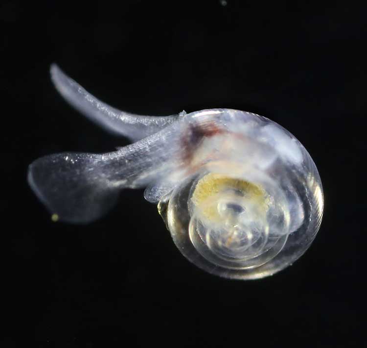
A healthy pteropod collected during the U.S. West Coast survey cruise. (NOAA)
Risk to Salmon, Mackerel and Herring
In a 2011-2013 survey, a NOAA-led research team found the first evidence: “that acidity of continental shelf waters off the West Coast is dissolving the shells of tiny free-swimming marine snails, called pteropods, which provide food for pink salmon, mackerel and herring.”
The survey estimated that the percentage of pteropods along the west coast with dissolving shells due to ocean acidification had “doubled in the near shore habitat since the pre-industrial era and is on track to triple by 2050 when coastal waters become 70 percent more corrosive than in the pre-industrial era due to human-caused ocean acidification.”
That study documented the movement of corrosive waters onto the continental shelf from April to September during the upwelling season, when winds bring water rich in carbon dioxide up from depths of about 120 to 180 metres to the surface and onto the continental shelf.
“We haven’t done the extensive amount of studies yet on the young salmon fry,” Cooley said. “I would love to see those studies done. I think there is a real need for that information. Salmon are just so so important for the entire Pacific Northwest and up to Alaska.”
In Prince Rupert, Barb Faggetter, an independent oceanographer whose company Ocean Ecology has consulted for the fisherman’s union and NGOs, who was not part of the study, spoke generally about the threat of acidification to the region.
She is currently studying the impact of the proposed Liquified Natural Gas terminals that could be built at Prince Rupert near the Skeena River estuary. Faggetter said that acidification could affect the species eaten by juvenile salmon. “As young juveniles they eat a lot of zooplankton including crustaceans and shell fish larvae.”
She added, “Any of the shell fish in the fishery, including probably things like sea urchins are all organisms that are susceptible to ocean acidification because of the loss of their capacity to actually incorporate calcium carbonate into their shells.”
Faggetter said her studies have concentrated on potential habitat loss near Prince Rupert as a result of dredging and other activities for liquified natural gas development, She adds that ocean acidification “has been a consideration that climate change will further worsen any potential damage that we’re currently looking at.”
Her studies of the Skeena estuary are concentrating on “rating” areas based on the food supply available to juvenile salmon, as well as predation and what habitat is available and the quality of that habitat to identify areas that “are most important for the juvenile salmon coming out of the Skeena River estuary and which are less important.”
She said that climate change and ocean acidification could impact the Skeena estuary and “probably reduce some of the environments that are currently good because they have a good food supply. If ocean acidification reduces that food supply that will no longer be good habitat for them” [juvenile salmon].
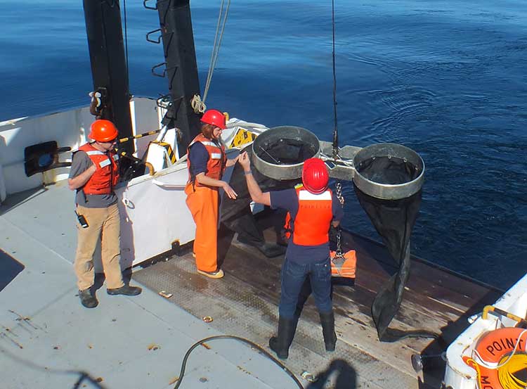
Bongo nets are deployed up to 200 meters deep to catch marine snails (pteropods), which are indicators of the progress of ocean acidification. The pteropod samples were collected during the U.S. West Coast survey cruises in 2011 and 2013. Unlike the US, Canada’s DFO is using models to track what’s happening to pteropods. (NOAA)
The August 2011 NOAA survey of the pteropods was done at sea using “bongo nets” to retrieve the small snails at depths up to 200 metres. The research drew upon a West Coast survey by the NOAA Ocean Acidification Program in that was conducted on board the R/V Wecoma, owned by the National Science Foundation and operated by Oregon State University.
Nina Bednarsek, Ph.D., of NOAA’s Pacific Marine Environmental Laboratory in Seattle, the lead author of the April pteropod paper said, “Our findings are the first evidence that a large fraction of the West Coast pteropod population is being affected by ocean acidification.
“Dissolving coastal pteropod shells point to the need to study how acidification may be affecting the larger marine ecosystem. These near shore waters provide essential habitat to a great diversity of marine species, including many economically important fish that support coastal economies and provide us with food.”
Ecology and economy
Today’s study on the effects of acidification on the Alaska fishery study examined the potential effects on a state where the fishing industry supports over 100,000 jobs and generates more than $5 billion in annual revenue. Fishery-related tourism also brings in $300 million annually to the state.
A map of Alaska shows the economic and ecological risks to parts of the state from ocean acidification. (NOAA)
The study also shows that approximately 120,000 people or roughly 17 percent of Alaskans rely on subsistence fisheries for most, if not all of their dietary protein. The Alaska subsistence fishery is open to all residents of the state who need it, although a majority of those who participate in the subsistence fishery are Alaska’s First Nations. In that way it is somewhat parallel to Canada’s Food, Ceremonial and Social program for First Nations.
“Ocean acidification is not just an ecological problem—it’s an economic problem,” said Steve Colt, Ph.D., co-author of the study and an economist at the University of Alaska Anchorage. “The people of coastal Alaska, who have always looked to the sea for sustenance and prosperity, will be most affected. But all Alaskans need to understand how and where ocean acidification threatens our marine resources so that we can work together to address the challenges and maintain healthy and productive coastal communities.”
The Alaska study recommends that residents and stakeholders in vulnerable regions prepare for environmental challenge and develop response strategies that incorporate community values and needs.
“This research allows planners to think creatively about ways to help coastal communities withstand environmental change,” said Cooley, who is now science outreach manager at Ocean Conservancy, in Washington, D.C. “Adaptations can be tailored to address specific social and environmental weak points that exist in a community.
“This is really the first time that we’ve been able to go under the hood and really look at the factors that make a particular community in a borough or census are less or more vulnerable from changing conditions resulting from acidification. It gives us a lot of power so that we don’t just look at environmental issues but also look at the social story behind that risk.”
As for the southern part of the Alaska panhandle nearest British Columbia, Cooley said, “What we found is that there is a high relative risk compared to some of the other areas of Alaska and that is because the communities there undertake a lot of subsistence fishing, There tend not be a whole lot of commercial harvests in the fisheries there but they are very very important from a subsistence stand point… And they’re tied to species that we expect to be on the front line of acidification, many of the clam species that are harvested in that area and some of the crab species.”
Long term effects
Libby Jewett, Director of the NOAA Ocean Acidification Program and author of the pteropod study said, “Acidification of our oceans may impact marine ecosystems in a way that threatens the sustainability of the marine resources we depend on.
“Research on the progression and impacts of ocean acidification is vital to understanding the consequences of our burning of fossil fuels.”
“Acidification is happening now,” Cooley said. “We have not yet observed major declines in Alaskan harvested species. In Washington and Oregon they have seen widespread oyster mortality from acidification.
“We don’t have the documentation for what’s happening in Alaska right now but there are a lot of studies staring up right now that will just keep an eye out for that sort of thing, Acidification is going to be continuing progressively over the next decades into the future indefinitely until we really curb carbon dioxide emissions. There’s enough momentum in the system that is going to keep acidification advancing for quite some time.
“What we need to be doing as we cut the carbon dioxide, we need to find ways to strength communities that depend on resources and this study allows us to think differently about that and too really look at how we can strengthen those communities.
Faggetter said. “It’s one more blow to an already complex situation here, My study has been working particularly on eel grass on Flora Bank (pdf) which is a very critical habitat, which is going to be impacted by these potential industrial developments and that impact will affect our juvenile salmon and our salmon fishery very dramatically, that could be further worsened by ocean acidification.”
She said that acidification could also be a long term threat to plans in Prince Rupert to establish a geoduck fishery (pronounced gooey-duck).
The popular large 15 to 20 centimetre clam is harvested in Washington State and southern BC, but so far hasn’t been subject to commercial fishing in the north.
NOAA said today’s study shows that by examining all the factors that contribute to risk, more opportunities can be found to prevent harm to human communities at a local level. Decision-makers can address socioeconomic factors that lower the ability of people and communities to adapt to environmental change, such as low incomes, poor nutrition, lack of educational attainment and lack of diverse employment opportunities.
NOAA’s Ocean Acidification Program and the state of Alaska are also developing tools to help industry adapt to increasing acidity.
The new NOAA study is the first published research by the Synthesis of Arctic Research (SOAR) program. which is supported by an inter-agency agreement between NOAA’s Office of Oceanic and Atmospheric Research and the Bureau of Ocean Energy Management (BOEM) Alaska Region.
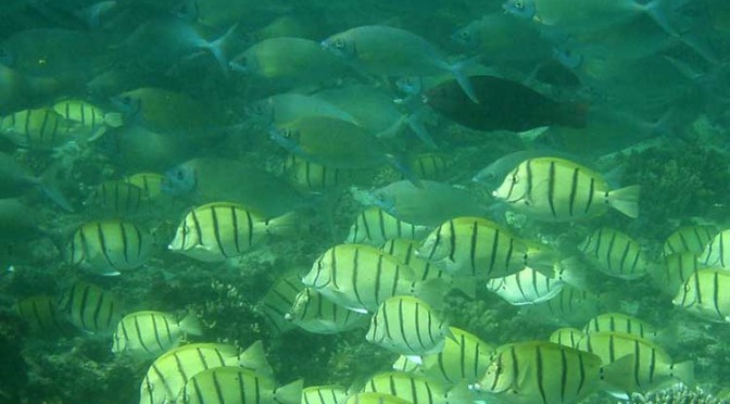
Tropical fish are migrating into what were once temperate water as a result of ocean warming and that poses a serious threat to the areas they invade, because they overgraze on kelp forests and seagrass meadows, according to a new study from the University of New South Wales in Australia
The study says the harmful impact of tropical fish is most evident in southern Japanese waters and the eastern Mediterranean, where there have been dramatic declines in kelps.
A school of tropical plant-eating fish including various species that are shifting their distribution towards temperate waters. (Adriana Verges/UNSW)
There is also emerging evidence in Australia and the US that the spread of tropical fish towards the poles is causing damage in the areas they enter.
“The tropicalisation of temperate marine areas is a new phenomenon of global significance that has arisen because of climate change,” according to the study lead author, Dr. Adriana Verges, of the University of New South Wales.
“Increases in the number of plant-eating tropical fish can profoundly alter ecosystems and lead to barren reefs, affecting the biodiversity of these regions, with significant economic and management impacts.”
The study is published in the journal Proceedings of the Royal Society B.
As the oceans have warmed and the climate has changed, hotspots are developing in regions where the currents that transport warm tropical waters towards the poles are strengthening.
Increased flow of the East Australian Current, for example, has meant waters south-east of the continent are warming at two to three times the global average.
Tropical fish are now common in Sydney Harbour during the summer months.
Japan, the east coast of the US, northern Brazil and south eastern Africa are also strongly influenced by coastal currents that transport warm tropical waters.
“In tropical regions, a wide diversity of plant-eating fish perform the vital role of keeping reefs free of large seaweeds, allowing corals to flourish. But when they intrude into temperate waters they pose a significant threat to these habitats. They can directly overgraze algal forests as well as prevent the recovery of algae that have been damaged for other reasons,” Dr Verges said.
Tropical fish expanding their ranges into temperate areas include unicornfish, parrotfish, and rabbitfish.
The study authors include researchers from Australia, the US, Spain, Singapore, the UK and Japan.
Kelp disappears in southern Japan
The study reports that more than 40 per cent of the kelp and algal beds have disappeared since the 1990s, a phenomenon known in Japan as isoyake.
Tropical species including rabbitfish and parrotfish appear to be mainly responsible.
Although these fish have been present for a long time, their annual grazing rates have increased dramatically as ocean temperatures in winter have risen. Corals now dominate the ecosystem in many locations. The changes have led to the collapse of the abalone fishery.
Rabbit fish expand in eastern Mediterranean
Tropical fish moved into the eastern Mediterranean from the Red Sea after the opening of the Suez Canal. In recent decades, rabbitfish numbers have increased, resulting in hundreds of kilometres of deforested areas and a 40 per cent decrease in the variety of marine species.
As the Mediterranean warms the rabbitfish are expanding their range westward, putting other shallow ecosystems at risk.
Gulf of Mexico
There has been a more than 20-fold increase in the number of parrotfish in the Gulf of Mexico – a species which consumes seagrass at five times the rate of native grazers. The number of plant-eating green turtles and manatees has also increased.
Australia
In Western Australia, emerging evidence suggests that increases in the number of tropical fish are preventing the recovery of kelp forest damaged by a heat wave in 2011.
In eastern Australia, kelp has disappeared from numerous reefs in the past five years and Dr Verges’ research suggests intense grazing by tropical fish on the kelp preceded this.
Zone maps for the North Coast marine draft plan. (MAPP)
District of Kitimat Council has urged residents to turn out in large numbers for consideration of the North Coast Draft Marine Plan at the Kitimat Valley Institute Tuesday, May 13, from 5:30 to 8:30.
In introducing the motion, Mayor Joanne Monaghan said she was worried that not enough Kitimatians, especially charter operators, boaters and fishers were aware of the meeting.
Another council member privately said he was worried that the Open House and Forum weren’t publicized enough so that the town could be checked off as having “been consulted.”
MAPP stands for Marine Planning Partnership for the North Pacific Ocean.
According to the documents the purpose of the North Coast Marine Plan “is to provide recommendations for achieving a sustainable balance between ecosystem health, social and cultural well-‐being and economic development through an ecosystem-‐based approach to planning and management.”
The plan is all about managing “common First Nation and provincial interests related to marine areas.”
The parners include the province and the Skeena First Nations Stewardship Society (NCSFNSS), representing the Metlakatla, Kitsumkalum, Kitselas, Haisla, Gitga’at, and Gitxaala Nations.
According to the doucments the North Coast plan area covers 27,000 kilometres of coastline;
that is indented with deep fjords and dotted with thousands of islands. It is a region of profound beauty, significant ecological diversity and remarkable cultural richness. Prince Rupert, Terrace and Kitimat are the largest communities in the North Coast plan area, which supports an overall population of approximately 42,000.
According to the summary of the plan:
The physical complexity of the North Coast includes a range of ecosystem types, including important estuaries that support distinct marine ecosystems and species. A diverse range of economic and community activities occur within the North Coast plan area. Commercial fisheries and associated processing facilities and logging have supported communities along the coast since the early 1900s. These activities continue to be important to the well-‐being of coastal communities. Port activities centered around the communities of Prince Rupert, Kitimat and Stewart, and active recreational fishing and tourism sectors, continue to be strong economic drivers in the area. North Coast First Nations living in the region have distinct cultural and spiritual heritages that are intricately linked to the marine environment and the long-‐standing sustainable use and management of marine resources.
The plan appears to overlap some areas where there have been environmental assessments of the Northern Gateway and the numerous liquified natural gas proposals.
The plan summary goes on to say:
The draft plan brings together science and Aboriginal knowledge, input from the technical staff of NCSFNSS (representing the Gitga’at, Gitxaała, Metlakatla, Kitsumkalum, Kitselas and Haisla Nations) and the Province. Key information and direction was provided by First Nations strategic marine use plans and existing provincial planning and policy documents.
Ecological, cultural and social and economic data sources were compiled and analysed by the joint technical team and contract support. Relevant background scientific reports and technical documents from the Pacific North Coast Integrated Management Area (PNCIMA) process were also used, along with the BC Marine Conservation Analysis. Additional information was drawn from government reports and publications, academic literature, industry or sector publications, discussions with experts and local knowledge. Advice was also incorporated from the North Coast Marine Plan Advisory Committee and public and stakeholder engagement.
The Pacific North Coast Integrated Management Area process was killed by the Harper government in the fall of 2011 . The decision to kill the PNCIMA was officially for budget reasons, but general speculation at the time was that Harper and then Natural Resources Minister Joe Oliver wanted to kill PNCIMA as one way of ensuring the government could push through the Northern Gateway project. The MAPP program was set up by the province and First Nations as a reaction to Harper’s decision.

Pacific NorthWest LNG (PNW LNG) announced today that the required technical and commercial components of the project have been satisfied. Consequently, PNW LNG has resolved to move forward with a positive Final Investment Decision, subject to two conditions.
Progress Energy Canada and the North Montney Joint Venture partners will continue to invest in its North Montney natural gas resources. The investment to date has proved and probable natural gas reserves of over 20 trillion cubic feet (tcf) with $2 billion-plus invested annually, representing approximately 4,000 sustainable jobs in northeast British Columbia.