Environment Earthquake
Last updated 1444 PT

A 6.4 magnitude earthquake struck off the west coast of Vancouver Island at 12:41 PM PT, Friday, Sept. 9, 2011. Iniitial reports say there were was no damage or injuries. The US Geological Survey first set the magnitude at 6.7, but that was later revised to 6.4 A 6.4 magnitude is considered a major earthquake. The quake was not felt in the Kitimat region but was in Vancouver Island towns like Campbell River, Port Alice and Port Hardy. In the small village of Zeballos, residents gathered quickly at an emergency gathering point, but it was soon clear that danger had passed and there were no injuries. Shaking was felt in Vancouver and Victoria, as far south as Seattle and east to Abbotsford.
US Geological Survey page on the Vancouver Island earthquake.
The West Coast and Alaska Tsunami Warning Centre has not issued a tsunami alert.
To: U.S. West Coast, Alaska, and British Columbia coastal regions
From: NOAA/NWS/West Coast and Alaska Tsunami Warning Center
Subject: Tsunami Information Statement #1 issued 09/9/2011 at 12:43PM PDTA strong earthquake has occurred, but a tsunami IS NOT expected along the California, Oregon, Washington, British Columbia, or Alaska coast. NO tsunami warning, watch or advisory is in effect for these areas.
Based on the earthquake magnitude, location and historic tsunami records, a damaging tsunami IS NOT expected along the California, Oregon, Washington, British Columbia, and Alaska coasts. Some of these areas may experience non-damaging sea level changes. At coastal locations which have experienced strong ground shaking, local tsunamis are possible due to underwater landslides.
The USGS says the epicentre was 119 km WNW of Ucluelet, 138 km WSW of Campbell River, 140 km SSE of Port Hardy and 289 km WNW of Victoria.
US Geological Survey maps showing history of earthquakes off Vancouver Island.
Earthquakes Canada information page from Natural Resources Canada.
Northwest coast hazards
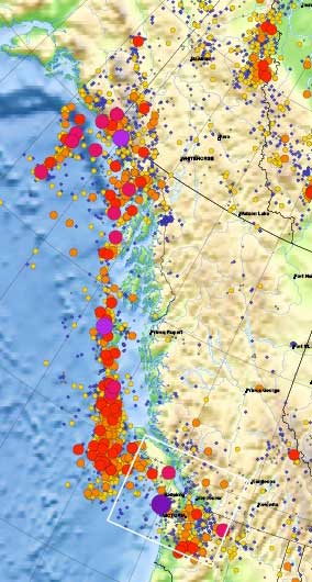 This detail of the Natural Resources Canada/ Earthquakes Canada shows the historical record of earthquakes along the northwest coast of British Columbia. The larger the circle, the greater the magnitude.
Most, not all, the earthquakes took place in the tetonic plate boundaries off the coast in the middle of the Pacfic Ocean, although the map does also show quakes on Haidi Gwaii. However, large quakes can be felt far inland. The magnitude 9.2 Good Friday earthquake in Alaska in 1964 did shake the town of Kitimat.
Media links
CBC :Earthquake strikes off Vancouver Island’s west coast
Global BC 6.4 earthquake hits off Vancouver Island
Globe and Mail
6.4 earthquake hits off Vancouver Island