Did the 1964 tsunami bring a dangerous tropical fungus to the BC Coast?

In 1999, a tropical fungus called by scientists Cryptococcus gattii unexpectedly appeared on Vancouver Island. Spores from the fungus can cause a sometimes fatal pneumonia-like illness in humans, cats, dogs and marine mammals, including porpoises and dolphins. There is one reported case of the fungus infecting a great blue heron.

Normally, the fungus is most common in Papua New Guinea, Australia and South America. Today it is also found growing in the coastal forests and shoreline areas of southern coastal British Columbia, Washington and Oregon.

A study, released today, supported by the US Centres for Disease Control and Prevention (CDC) is described as tracking multiple pieces of a puzzle. It suggests that a singular event, like a natural disaster, could have been the missing piece that brought the whole picture together.

The scientists, microbiologist Arturo Casadevall, MD, PhD, Chair of Molecular Microbiology and Immunology at the Bloomberg School at Johns Hopkins University, and epidemiologist David Engelthaler, PhD, of the Translational Genomics Research Institute, Flagstaff, Arizona, suggest that a series of events brought the fungus to BC culminating in its possible spread by the tsunami unleashed by the 1964 magnitude 9.2 earthquake in Anchorage, Alaska. The scientists wrote that the tsunami idea seemed to fit the “when, where, and why” of this disease emergence.

The US CDC has tracked more than 300 C. gattii fungal infections in the Canadian and U.S. Pacific Northwest region since the first case on Vancouver Island in 1999. Prior to that time, infections with this fungus had been confined almost entirely to Papua New Guinea, Australia, and South America. The fungus typically infects people through inhalation. It can cause a pneumonia-like illness, and may also spread to the brain, causing a potentially fatal meningoencephalitis. Although the disease is fairly rare and few infected people become ill, for those who become infected, published case reports suggest an overall mortality rate of more than 10 percent.
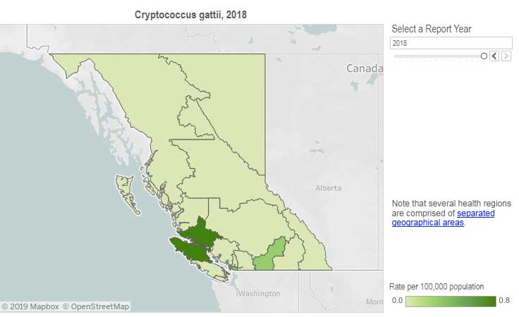
Incidence of Cryptococcus gattii infection in BC (BCCDC)

The British Columbia Centre for Disease Control (BCCDC) says Vancouver Island has one of the highest rates of infection in the world. Each year in B.C. from 10 to 25 people become sick from cryptococcosis and about 16 per cent die from the disease.

In the Northern Health region, however, only one case, in 2017, has been reported since 2009 and that was in the Northern Interior region.
The BCDC says the fungal infection can take several months to incubate after exposure. Only a few people exposed to the spores will become ill. Cryptococcus gattii is a reportable disease in British Columbia.

The new study is suggesting that the fungus first traveled in ships’ ballast tanks. After the Panama Canal opened in 1914, shipping increased significantly between Atlantic and Pacific ports.

The scientists believe that in South America, the fungus began washing from local rivers into shore waters. Then ships loaded ballast water, which research has shown is a common mode of transport for invasive species. The ballast water then spread the fungus to North American waters. Ships in those days routinely took on such ballast water in one port and simply discharged it, without treatment, in another.

How the tropical pathogen established itself in such a cool northern area was originally unclear. Theories have included global warming and the import of tropical eucalyptus trees.

The new study proposes that once in the North Pacific the fungus went unnoticed until the 1964 earthquake brought the fungus widely ashore and into coastal forest area.

It then took several decades for the fungus to evolve in its new habitat so that it could survive and then thrive first in coastal Vancouver Island, then across the island to the Lower Mainland and down to Washington and Oregon.

Casadevall says, “The big new idea here is that tsunamis may be a significant mechanism by which pathogens spread from oceans and estuarial rivers onto land and then eventually to wildlife and humans, If this hypothesis is correct, then we may eventually see similar outbreaks of C. gattii, or similar fungi, in areas inundated by the 2004 Indonesian tsunami and 2011 Japanese tsunami.”

The Alaskan Earthquake was felt as far as 4,500 kilometres away. Effects were recorded on the Hawaiian Islands. The waves reported in nearby Shoup Bay, Alaska were 67 metres causing significant shoreline devastation. At Seward, Alaska, the tsunami wave was 9.2 metres. At Port Alberni it was 6.4 metres. North of Kitimat, at Ketchikan, the wave was just 0.6 metres and at Prince Rupert, 1.4 metres. There are no figures for Kitimat, but with no damage reported, it is likely that the wave was somewhere around a metre.

The tsunami continued south, affecting much of the coastline of western North America, even causing several deaths on the beaches of northern California.

Several hours after the earthquake, multiple waves flowed up Alberni Inlet, cresting at eight metres and striking the Port Alberni region, washing away 55 homes and damaging nearly 400 others

The study retrieved multiple fungus samples from the forests in the Port Alberni region. Studies show there are multiple infected sea mammals in the port’s waterways. Human and terrestrial and marine animal cases have also been reported along the western coast of Vancouver Island. The results suggest that the contamination of the Port Alberni region may be from the 1964 tsunami rather than from terrestrial dispersal from the eastern side of Vancouver Island.
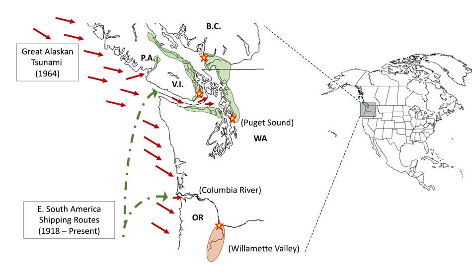
Map showing where the 1964 tsunami could have deposited the fungus (Ecological and Evolutionary Science)

The early environmental analyses in British Columbia identified that the fungus was found in soils and trees in the coastal Douglas fir forests and in coastal Western Hemlock forests bordering the coastal Douglas fir forest. While these studies were “limited in geographical space” the contaminated landscapes were also the known locations of human and animal infections. Further ecological analyses have identified higher levels of soil and tree contamination at low-lying elevations close to sea level.

The researchers now hope to continue testing their hypothesis with detailed analyses of C. gattii in soils within and outside tsunami-inundated areas of the Pacific Northwest. They then want to compare the British Columbia fungus with DNA collected from other parts of the world.–to see if the same C. gattii subtypes found in Brazil and the Pacific Northwest are more widely present in seawaters around ports.

The paper: “On the emergence of Cryptococcus gattii in the Pacific Northwest: ballast tanks, tsunamis and black swans” by David Engelthaler and Arturo Casadevall is in the journal Ecological and Evolutionary Science

BCDC defintion
Cryptococcus is a tiny (microscopic) yeast-like fungus. A species of this fungus, called Cryptococcus gattii, has been living on trees and in the soil on the east coast of Vancouver Island since at least 1999. More recently it has also been found in the Vancouver Coastal and Fraser Health regions. Infrequently, people and animals (e.g. cats, dogs, llamas, porpoises) exposed to this fungus become sick with cryptococcal disease (or cryptococcosis). Cryptococcosis can affect the lungs (pneumonia) and nervous system (meningitis) in humans. It affects people with healthy and weakened immune system. In rare cases, this disease can be fatal.

Many people will be exposed to the fungus sometime during their lives and most of these will not get sick. In people who become ill, symptoms appear many months after exposure.

Symptoms of cryptococcal disease include:

Prolonged cough (lasting weeks or months)
Shortness of breath
Headache
Vomiting
Fever
Weight loss
If symptoms occur, the disease can cause pneumonia, meningitis, nodules in the lungs or brain, or skin infection.

People are advised to see their doctor if they live in or visit an area where the fungus can be found and experience these symptoms.
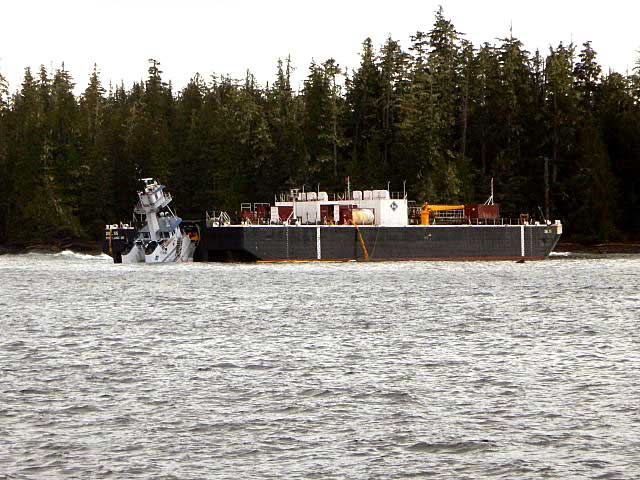
Second mate of tug Nathan E. Stewart asleep on watch when it grounded off Bella Bella: NTSB

The second mate of the tug Nathan E. Stewart fell asleep on watch when the tug grounded off Bella Bella, on October 13, 2016, according to an investigation report released by the United States  National Transportation Safety Board.

The NTSB also  said “Contributing to the grounding was the ineffective implementation of the company’s safety management system procedures for watchstanding.”

Both the NTSB and the Canadian Transportation Safety Board investigated the grounding. The tug was American owned and crewed while the accident happened in Canadian waters. The TSB investigation on the incident is continuing and no report has been released. 

The Nathan E. Stewart was pushing, not towing the barge, as the NTSB report notes:

The JAK system the tug used to push the barge (NTSB)

The tugboat Nathan E Stewart and the tank barge DBL 55 were connected through the JAK coupling system.1 Controlled from a panel on the tugboat’s bridge, this system uses a 16-inch-diameter, high-strength steel pin pneumatically actuated on each side of the vessel’s bow to lock the vessel into a fitted socket plate welded to each side of the barge’s inner notch. The plates have multiple sockets that run vertically, which allows the tugboat to position itself within the notch to accommodate changing barge drafts as well as to prevent, or minimize, the horizontal movement between the two units.

The NTSB says the grounding of the tug caused about  $12 million US in estimated damage to the tug itself and the barge it was pushing.

The Nathan E. Stewart and barge on the rocks (RCMP/TSB)

The Nathan E Stewart spilled 29,000 gallons of fuel and lube oil, released into the ocean off Edge Reef, off Athlone Island in Seaforth Channel in the traditional territory of the Heiltsuk Nation.

Although no petroleum products were released from the empty fuel barge, a subsequent marine survey found that post accident survey of the DBL 55 found that the barge’s external double hull was significantly damaged from its bow completely aft to the skegs on the stern. There were multiple areas where the hull plating had been inset and penetrated. Some of the framing also had been damaged, but none of the inner steel plating comprising the bottom, sides,or top of the cargo tanks had been breached. The JAK socket plates on the inside of the barge’s notch showed slight damage,with the second recess(fromthe bottom up) on both socket plates indicating scarring and heavy contact. Repair costs for the barge were estimated at $5.6 million.

Prior to thegrounding, all the vessel’s vital systems were functional, and there were noindications of a mechanical failure thatmay haveled to the accident.

The NTSB says the tug was on autopilot when the second mate fall sleep on watch and it missed course correction near Ivory Island. The tug had a computerized electronic chart system (ECS) on board that should have sounded an alarm when the way point for the course correction was missed, but the mate told the NTSB,  the tug was not using that navigation tool on the night of the accident. According to the second mate, it was
normal practice for the navigation team to not utilize that tool.

The NTSB report says had the ECS  been utilized, the ECS would
have entered into an alarm mode after the second mate missed the port course change required near Ivory Island. Based on time, speed, and distance calculations, the alarm would have activated at approximately 0055 and thereby provided ample time for the second mate to take
corrective action to return the Nathan E Stewart to the intended track.

Download the complete NTSB report:
 NTSB report MAB1738 NathanStewart (pdf)

Analysis:   New scientific findings likely confirm Haisla story of first arrival in the valley

Two related scientific papers published in the past two weeks, one on the First Peoples  initial settlement of coastal  North America and the second  giving a probable new timeline of the retreat of the glaciers during the last Ice Age,  taken together  are likely confirmation of the Haisla story of how that nation first settled the Kitimat Valley.

Haisla NationAs related in Gordon Robinson’s Tales of the Kitamaat, the First Peoples living on the coast of what is now British Columbia ventured up what is now called Douglas Channel perhaps from either Bella Bella in Heiltsuk traditional territory or from Prince Rupert in Tsimshian traditional territory.

The young men on the expedition up the Kitimat Arm spotted what they thought was a huge monster kilometres ahead with a large mouth that was constantly opening and closing. The sight was so terrifying that the men fled back to their homes and dubbed the Kitimat Arm as a place of a monster.

Later a man named Hunclee-qualas accidentally killed his wife and had to flee from the vengeance of his father-in-law.   Knowing he had to find a place where no one could find him,  he ventured further up the Kitimat Arm. There he discovered that the “monster” was nothing more than seabirds, probably seagulls, perhaps feasting on a spring oolichan run.

He settled along the shore of what is now the Kitimat River and found a land of plenty, with fish, seals, game as well as berries and other natural products of the land.  Eventually he invited others to join him, which began the Haisla Nation and he became their first chief.

Let’s examine the new evidence so far.

  1. Settlement along the coastal “kelp highway” between 18,000 and 16,000 years ago, followed by a warm spell 14,500 years ago

It’s now fairly certain that the First Peoples first began to settle along the coast by following the “kelp highway” perhaps as early as 18,000 years ago and certainly by 14,000 years ago.  Haida Gwaii was ice free, except for some mountain glaciation as early as 16,500 years ago.   At about 14,500 years ago there was a warming spell which forced the glaciers to retreat, brought higher sea levels and the arctic like tundra ecosystem would have been replaced, at least for a time, by forests. There is the discovery of a Heiltsuk settlement dated to 14,000 years ago.  At that time almost all of the coast would have been free of glacial ice but there were still glaciers in the fjords, including the Kitimat Arm which would mean there could be no permanent settlement in the “inland coast” and the interior.

(Science)
  1. The cooling period from 14,000 to 11,700 years ago confines settlement to the coast

The cooling periods  (with occasional warmer times) from about 14,000 years ago to about 11,700 years ago meant that settlement would largely have been confined to the coast for about two and half millennia. The culture of the coastal First Peoples would have been well established by the time the glaciers began the final retreat.

(Remember that it is just 2,000 years from our time in 2017 back to the height of the Roman Empire under Augustus Caesar).

It is likely that the cooling periods also meant that some descendants of initial settlers likely headed south for relatively warmer climates. Rising sea levels meant that the initial settlement villages would likely have been abandoned for higher ground.

  1. A second period of rapid warming 11,700 years ago which opens up the interior fjords and valleys

At the end of what geologists call the Younger Dryas period, about 11,500 years ago, the climate warmed, the glaciers retreated further, in the case of Kitimat, first to what is now called Haisla Hill, then to Onion Flats and finally to Terrace.

  1. Large glacial sediment river deltas filled with fresh melt water from retreating ice

The most important confirmation of the story of Hunclee-qualas’s exile is the account  of the monster, the birds and the oolichan run.

The new scientific evidence, combined with earlier studies, points to the fact that the glacial melt water carried with it huge amounts of glacial sediment that created vast river deltas in coastal regions of the Northern Hemisphere.

That means around 10,000 years ago,   when the Kitimat Valley was ice free and the new forest ecosystem was spreading up the valley, the Kitimat River estuary was likely to have been much larger than today.  It could have been a vast delta, which would have quickly been repopulated with fish, including salmon and oolichan. That rich delta ecosystem could have supported a much larger population of seabirds than the smaller estuary in recent recorded history.

Snow geese by the thousands in the Sacramento-San Joaquin Bay Delta/ CrunchySkies/Wikimedia Commons/Creative Commons License

The story of the monster those first travelers saw far off is highly plausible. Even today in huge, rich deltas elsewhere in the world, seeing hundreds of thousands of birds in flight over a wetland is fairly common. (For a description of what a Kitimat River delta may have been like thousands of years ago, see KCET’s story on the Sacramento-San Joaquin Bay Delta and what that delta was like 6,000 years ago)

The First Peoples had had well established communities for up to four thousand years before the Kitimat Valley’s metres of thick ice had melted away.  For the first period, while the ecosystem regenerated, for the people of the coast coming up Douglas Channel to the valley would not have been worth it, there would be little to find in terms of fish, game or forest resources.

A Snow Goose flock near the Skagit River Delta, WA./ Walter Siegmund/Wikimedia Commons
  1. The change from tundra to a rich forest environment

Eventually as the forest regenerated, the streams filled with salmon and oolichan; the bird population including gulls, geese and eagles, found a new feeding ground;  bears, deer and other animals arrived. The Kitimat region would have been an attractive place to explore and hunt. It may be the monster story did keep people away until Hunclee-qualas had to find a place to hide and discovered a new home just at a time that might be called an ecological optimum with new forests stretching back along the valley to what is now Terrace.

  1. The river delta shrinks back to the current estuary

If a vast Kitimat River delta did stretch further down the Channel than it does in 2017, it likely shrank back in the subsequent millennia.   Eventually the mass of glacial sediment that came downstream after the retreat of the ice would diminish, but not stop entirely. The estuary is still rebuilt from sediments washed downstream but that sediment doesn’t match other  rich deltas elsewhere such as the Nile in Egypt.   With that regeneration of the delta slower and smaller than in the first centuries of Haisla settlement, at the same time the land surface rebounded from the weight of the ice, perhaps creating the Kildala neighborhood.  The ocean level rose, drowning and eroding part of the old delta, creating the estuary we know today.


As the authors of the paper on the First Peoples’ settlement note, most of the archaeological evidence of early coastal settlement is now likely many metres below the surface of the ocean but deep ocean exploration may uncover  that evidence.  As the scientific team on the second paper say, they are now working on detailed studies of the glacial retreat from the coastal mountain region which may, when the studies are complete, change the timeline

While waiting for further evidence from archaeology and geology it is safe to say that the stories of the monster and later Hunclee-qualas’s discovery of the Haisla homeland are even more compelling than when Gordon Robinson wrote Tales of the Kitamaat.  We can now speculate that there was once, stretching from Haisla Hill far down the Channel, a vast, varied rich, river estuarine delta that supported hundreds of thousands of seabirds, which if they took the wing in unison, would have made those unwary travelers millennia ago, really think that there was a giant monster waiting to devour them at the head of the Kitimat Arm.


The end of the Ice Age in coastal British Columbia may indicate what will happen to shrinking ice sheets in Greenland, study indicates

If some travellers, perhaps about 12,000 years ago, had headed up what is now called Douglas Channel, around the north end of Hawkesbury Island they likely would have seen a glacial retreat driven by a warming planet, something very familiar to the television viewers of 2017, video of 21st century coastal Greenland, where massive glaciers are calving ice bergs into the ocean.

The history of rapid glacial retreat over several thousand years from the interior and coastal British Columbia at the end of the last Ice Age is now becoming a crucial indicator of what may happen to both Greenland and the Antarctica. Under the current ice sheets both Greenland and parts of Antarctica are mountain ranges similar to those here in British Columbia. According to new research published to today in Science, that may indicate what could happen as those ice sheets melt and how that will affect  volatile climate change.

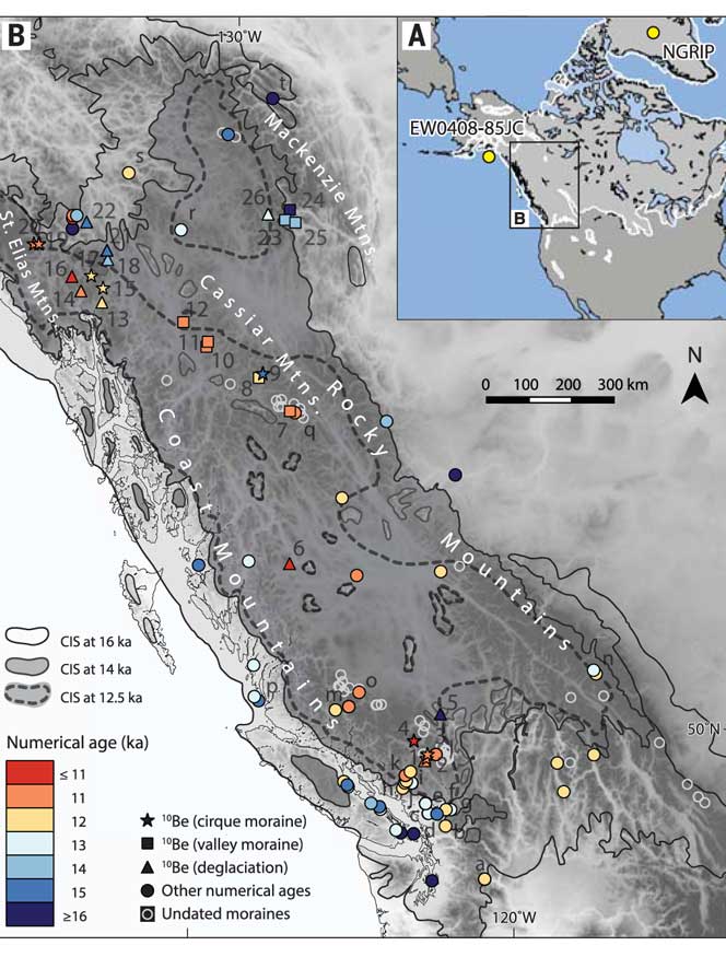
The paper written by Brian Menounos of the University of Northern British Columbia and co-authors indicates that the glacial retreat  in BC was faster than previously believed, beginning about 14,000 years ago. That left some parts of  coastal and western  BC ice free, rather than beginning 12,500 years ago as previously estimated. The last Ice Age probably reached its maximum coverage about 20,000 years ago.

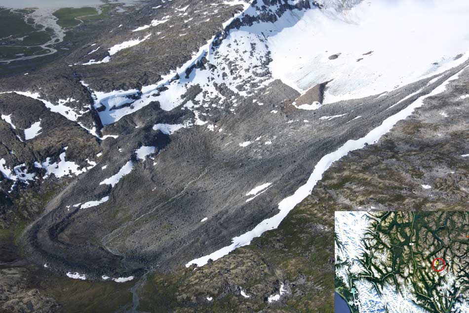
One of the cirque moraines at the end of a glacier studied by Brian Menounos and his team. It is in northern British Columbia just south of the Yukon border. ( Brian Menounos/Science plus Google Earth)

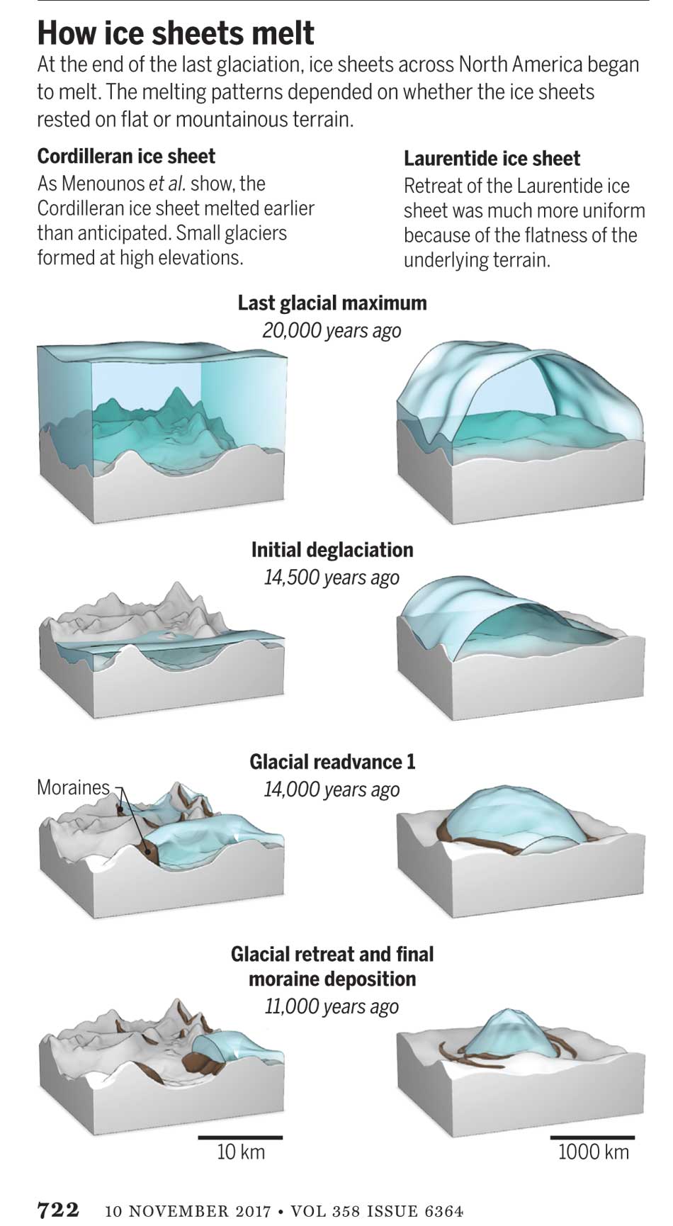
The decay of the ice sheet was complex, partly due to presence of mountainous terrain and also because Earth’s climate rapidly switched between cold and warm conditions during the end of the last Ice Age.
One of the factors that may have triggered a climate change back to colder conditions was a massive outflow of cold, fresh water from coastal British Columbia, which may have affected ocean currents.

What geologists call the Cordilleran ice sheet once covered all of present-day British Columbia, Alaska and the north Pacific United States. How the Cordilleran ice sheet responded to climate change was different from the Laurentide ice sheet which covered the flatter terrain (prairie and the Canadian Shield) of central North America. The Cordilleran ice sheet is about the same size as the current Greenland ice sheet.

“Our work builds upon a rich history of collaborative research that seeks to understand when and how quickly the Cordilleran ice sheet disappeared from Western Canada,” Menounos says. “Projected sea level rise in a warming climate represents one of the greatest threats to humans living in coastal regions. Our findings are consistent with previous modeling studies that show that abrupt warming can quickly melt ice sheets and cause rapid sea level rise.”

Menounos, the Canada Research Chair in Glacier Change, teamed up with 14 co-authors from Canada, the United States, Sweden, Switzerland and Norway to produce the paper titled Cordilleran Ice Sheet mass loss preceded climate reversals near the Pleistocene Termination.

One of the co-authors of the paper is John Clague, now a professor emeritus of Earth Science at Simon Fraser University who studied the glaciation patterns in the Kitimat valley and Terrace in the 1970s when he worked for the Geological Survey of Canada.

Earlier researchers, including Clague, relied on radiocarbon dating to establish when the ice sheets disappeared from the landscape. The problem is that radiocarbon dating may not work in higher alpine regions where fossil organic matter is rare (above the tree line).

Menounos and the researchers used surface exposure dating – a technique that measures the concentration of rare beryllium isotopes that accumulate in quartz-bearing rocks exposed to cosmic rays – to determine when rocks first emerged from beneath the ice. If the rocks are under an ice sheet that means they are not exposed to cosmic rays, and thus measuring the beryllium isotopes can indicate when the retreating ice exposed the rocks to the cosmic rays.

The scientists studied small “cirque moraines” found only beyond the edge of modern glaciers high in the mountains, and valley moraines.

The alpine cirque moraines could not have formed until after the Cordilleran ice sheet had retreated. Menounos and his team show that several alpine areas emerged from beneath the ice sooner than previously believed. Then once the mountain peaks emerged from the thinning ice, new, smaller glaciers grew back over the high-elevation cirques at the same time that remnants of the ice sheet “reinvigorated” in the valleys during subsequent climate reversals

Most of the work of the team was done in the interior of British Columbia, the Yukon and Northwest Territories. Menounos says that new, similar work is being done on the mountains of the coastal region which will be published when the research is complete.

At its maximum, the Cordilleran ice sheet likely extended from what is now the mainland coast across Hecate Strait to the east coast of Haida Gwaii.

Starting about 14,500 years ago, the planet entered a phase of warming, with the average temperature rising about 4 degrees Celsius over about a thousand years. The Cordilleran ice began to thin rapidly leaving what the paper calls a “labyrinth of valley glaciers,” which then allowed the alpine glaciers to re-advance.

Diagram from Science shows how the glaciers retreated at the end of the last Ice Age, with the mountainous Cordilleran ice sheet behaving differently from the central North American Laurentide ice sheet (Science)

The scientists have suggested the rapid ice loss, beginning 14,500 years ago, came relatively quickly in geological time, perhaps just 500 years. That may have then contributed to subsequent Northern Hemisphere cooling through freshwater rushing into the ocean. That melt water disrupted the overturning ocean circulation of cold and warm water. That led to a new cooling period that lasted from about 14,000 to 13,000 years ago. (Similar to the completely fictional scenario in the movie The Day After Tomorrow,  where the cooling happens in days not centuries).

That same outflow could have raised then existing sea levels by two and half to three metres, Menounos says. (The overall sea level on Earth rose about 14 metres by the end of the Ice Age)

Then the climate reversed again, first briefly warming and then in a period that saw another abrupt change back to cooler conditions which geologists call the Younger Dryas,   The Younger Dryas occurred beginning about 12, 900 years ago to about 11,700 years ago, when warming began again. The Dryas is named after a wildflower that grows in arctic tundras.

The study indicates that the First Peoples could not have settled the interior of what is now British Columbia prior to the Younger Dryas, but it is likely as was explored in a paper last week in Science that the First Peoples were able to come down the “kelp highway” on the coast by at least 14,000 years ago.

Map of British Columbia showing the extent of the glaciation during the last Ice Age and now the ice retreated. The coloured graphics are where the study was done mostly in the interior of BC and the age of the deposits. KA means kilo-years or thousand years ago. (Science)

So what happened in Douglas Channel?

So what does the new study of glacial retreat mean for the history of Douglas Channel?

John Clague studied the Douglas Channel, the Kitimat Valley and the Terrace area in the 1970s and was one of the co-authors of the current study that provides a new timeline for the retreat of the glaciers on the British Columbia coast.

He says that the timeline from his work in the 1970s with radio carbon dating of fossilized organic material is fairly consistent with the new work by Brian Menounos of the University of Northern British Columbia using the beryllium isotope technique.

The paper, Clague says, is more of a general commentary on the last stages of the decay of the Cordilleran ice sheet.

“At the time we’re taking about in the paper, there was ice in the corridor between Kitimat and Terrace.

“What we see in detail based on the work I did ages ago, is the retreat of the glacier from the Kitimat Arm back to the north towards Terrace [in the Young Dryas ]. It occasionally stabilized and the melting ice discharged a lot of sediment into that marine embayment.

Based on his original work and the new study Clague says at the time, the mountains are beginning to become ice free but there was still ice in the major valleys such as the Skeena Valley and the corridor south of Terrace towards Kitimat.

“They’re overlapping stories.” Clague says.

“The ice sheet hadn’t completely disappeared at the time Brian is focusing on,” Clague says. “His point is that a lot of the mass of the ice sheet appeared to be thinning and through marginal retreat from Haida Gwaii and some of the islands off the mainland back toward the mainland itself. So we’re trying to put a chronology on it, as to the various steps in the glacial decay.”

The work seems to indicate that the final ice sheet retreat happened in four stages around 12,000 to 11,000 years ago. “I was interested in the detailed reconstruction of the ice front tracked north from Kitimat you see a number of periods when it stabilized long enough to build up very large deltas and braided melt water plains,” Clague says.

The first moraine is Haisla Hill in Kitimat, where the glaciers discharged large amounts of sediment into what is now Douglas Channel. The second is the hill leading to what is called Onion Flats, the third is the flat area where the Terrace Kitimat Regional Airport now is and the final stage of glacial retreat created the “terraces’ around Terrace and Thornhill.

“It’s interesting that in this area there was so much sediment discharged into the sea remarkably for the time over which the ice was retreating through the area. It had to have been a major kind of discharge point of water from the ice sheet south from Terrace towards Kitimat otherwise you wouldn’t get that huge amount of sediment deposited probably over a period of a thousand years. Then it retreated again to just north of the airport and anchored there for a while and we found evidence for a final last gasp upstream around Thornhill and that kind of near Terrace.”

“At that time some of the high elevation glaciers were re-energized and readvanced, but it probably didn’t affect the overall health of the ice sheet itself It’s such a big mass of ice that it doesn’t respond quickly to such a brief cooling so what we’ve done in many places is these glaciers actually advanced up against ‘the dead ice’ an ice sheet that was lower in elevation.”

At the times the oceans rose at the end of the Ice Age, there were “sea corridors” between Kitimat and Terrace and also in the Skeena Valley. “So you can imagine there were arms of the sea extending to Terrace from two directions almost making that area which is now part of the mainland an island.” But the region likely never did become a true island, Clague says because as the ice sheets retreated,, they were also shedding large amounts of sediment that would become land area at the same time as the earth’s crust was rebounding once it was freed from the weight of the ice sheet.


National Geographic maps Haisla and other First Nations’ traditional territory, pipeline routes and BC ‘s wild salmon

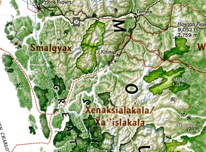
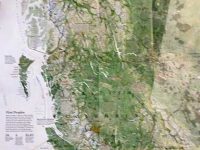
The September issue of National Geographic includes a large map of British Columbia it calls “Claiming British Columbia.”

natgeohaisla3
(National Geographic)

The map has three themes: First Nations’ traditional territory, the routes of proposed pipeline projects, both LNG and diluted bitumen, and it features a sub map that looks at what the map calls the “Troubled Salmon” fishery.

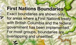
The cartographers at National Geographic are being very careful, avoiding such troubling issues as competing land claims among First Nations, unresolved land claims with the federal and provincial governments and treaty status.

natgeohaisla
(National Geographic)

So by and large the map groups First Nations by language group unless there are definite treaty or reserve boundaries. Large reserves under the Indian Act are on the map, but given the post stamp size of many reserves in British Columbia, those reserves are too small to be seen on the map. Towns and cities are identified as “First Nations” communities which often overlap with settler communities. Again the map misses many smaller communities, so Kitimat is on the map, while Kitamaat Village is not.

(National Geographic)

The map identifies Haisla traditional territory as “Xenaksilakala/Xa”islakala” and also includes the Kitlope Heritage Conservancy Protected area.

The article in the September issue is called The Pacific Coast, but unfortunately there is not much of a tie-in with the map, since it concentrates on California and Alaska with only a passing mention of British Columbia.

On the obverse side of the map is the poster that is promoted on the magazine cover, a beautiful painting of “The Changing Pacific Coast” which covers kelp and every creature from phytoplankton and zooplankton all the way to humpback whales and sea gulls (but for some reason no bald eagles). It is likely that poster will be on display in classrooms up and down the coast before school opens next week.

Ocean acidification a threat to the Dungeness crab: NOAA study

With climate change, the oceans are becoming more acid and that is a threat to the dungeness crab, according to a study by the US National Oceanic and Atmospheric Administration.

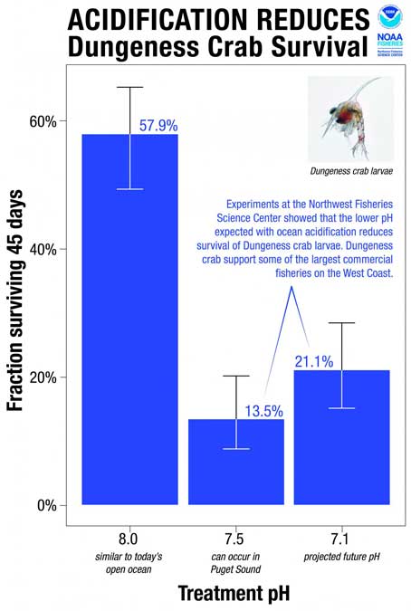
The study says ocean acidification expected to accompany climate change may slow development and reduce survival of the larval stages of Dungeness crab.

The dungeness crab is a key component of the Northwest marine ecosystem and vital to fishery revenue from Oregon to Alaska.

The research by NOAA Fisheries’ Northwest Fisheries Science Center in Seattle indicates that the declining pH anticipated in Puget Sound could jeopardize populations of Dungeness crab and put the fishery at risk. The study was recently published in the journal Marine Biology.

Ocean acidification occurs as the ocean absorbs carbon dioxide from the combustion of fossil fuels. Average ocean surface pH is expected to drop to about 7.8 off the West Coast by 2050, and could drop further during coastal upwelling periods.

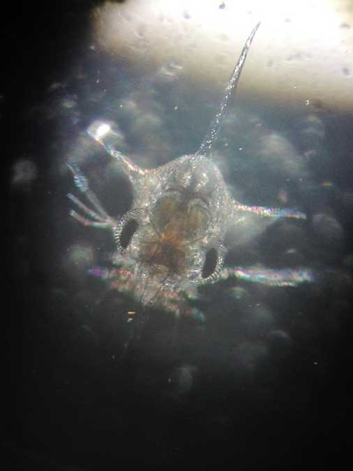
Survival of Dungeness crab larvae, called zoeae, declined at the lower pH levels expected with ocean acidification. (Jason Miller)
Survival of Dungeness crab larvae, called zoeae, declined at the lower pH levels expected with ocean acidification.
(Jason Miller)

Dungeness crab is the highest revenue fishery in Washington and Oregon, and the second most valuable in California, although the fishery was recently closed in some areas because of a harmful algal bloom. The Dungeness crab harvest in 2014 was worth more than $80 million in Washington, $48 million in Oregon and nearly $67 million in California

“I have great faith in the resiliency of nature, but I am concerned,” said Jason Miller, lead author of the research, which was part of his dissertation. “Crab larvae in our research were three times more likely to die when exposed to a pH that can already be found in Puget Sound, our own back yard, today.”

Scientists collected eggs from Dungeness crabs in Puget Sound and placed them in tanks at the NWFSC’s Montlake Research Laboratory. The tanks held seawater with a range of pH levels reflecting current conditions as well as the lower pH occasionally encountered in Puget Sound when deep water wells up near the surface. Larvae also went into tanks with the even lower-pH conditions expected with ocean acidification.
115757_webcrab
“The question was whether the lower pH we can expect to see in Puget Sound interferes with development of the next generation of Dungeness crab,” said Paul McElhany, a NOAA Fisheries research scientist and senior author of the paper. “Clearly the answer is yes. Now the question is, how does that play out in terms of affecting their life cycle and populations overall?”

Larvae hatched at the same rate regardless of pH, but those at lower pH took longer to hatch and progressed through their larval stages more slowly. Scientists suggested that the lower pH may reduce the metabolic rate of embryos. That could extend their vulnerable larval period, or could jeopardize the timing of their development in relation to key food sources, researchers suggested.

Larval survival also dropped by more than half at lower pH. At pH 8.0, roughly equivalent to seawater today, 58 percent of the crab larvae – called zoeae – survived for 45 days. At pH 7.5, which sometimes occurs in Puget Sound now, survival was 14 percent. At pH 7.1, which is expected to roughly approximate the pH of water upwelling on the West Coast with ocean acidification, zoeae survival remained low at 21 percent.

“Areas of greatest vulnerability will likely be where deep waters, naturally low in pH, meet acidified surface waters,” such as areas of coastal upwelling along the West Coast and in estuary environments such Hood Canal, the new study predicts.


BC launching major study of Kitimat River, Kitimat Arm water quality

The Environmental Protection Division of BC’s Ministry of Environment is launching a major study of the water quality in the Kitimat valley, first on the Kitimat River and some of its tributaries and later on the Kitimat Arm of Douglas Channel.

There has been no regular sampling by the province in Kitimat since 1995 (while other organizations such as the District of Kitimat have been sampling).

Jessica Penno, from the regional operations branch in Smithers, held a meeting for stakeholders at Riverlodge on Monday night. Among those attending the meeting were representatives of the District of Kitimat, the Haisla Nation Council, LNG Canada, Kitimat LNG, Rio Tinto BC Operations, Douglas Channel Watch, Kitimat Valley Naturalists and the Steelhead Society.

As the project ramps up during the spring and summer, the ministry will be looking for volunteers to take water samples to assist the study. The volunteers will be trained to take the samples and monitored to insure “sample integrity.” Penno also asked the District, the Haisla and the industries in the valley to collect extra samples for the provincial study and to  consider sharing historical data for the study.

With the growing possibility of new industrial development in the Kitimat valley, monitoring water quality is a “high priority” for the province, Penno told the meeting. However, so far, there is no money targeted specifically for the project, she said.

Fishing and camping on the Kitimat River
Camping and fishing on the Kitimat River. (Robin Rowland/Northwest Coast Energy News)

The purpose of the study is to make sure water in the Kitimat valley meet the provinces water quality objectives, which have the aim of watching for degradation of water quality, upgrade existing water quality or protect for designated uses such as drinking water, wildlife use, recreational use and industrial water supplies as well as protecting the most sensitive areas. It also provides a baseline for current and future environmental assessment. (In most cases, testing water quality for drinking water is the responsibility of the municipalities, Penno said.  The province may warn a municipality if it detects potential problems, for example if a landslide increases metal content in a stream).

Under the BC Environment system, “water quality guidelines” are generic, while “water quality objectives” are site specific.

One of the aims is to compile all the studies done of the Kitimat River estuary by the various environmental impact studies done by industrial proponents.

The ministry would then create a monitoring program that could be effectively shared with all stakeholders.

At one point one member of the audience said he was “somewhat mystified” at the role of Fisheries and Oceans in any monitoring, noting that “when you phone them, nobody answers.”

“You mean, you too?” one of the BC officials quipped as the room laughed.

Water quality objectives

The last time water quality objectives were identified for the Kitimat River and arm were in the late 1980s, Penno told the meeting. The objectives were developed by the British Columbia government because of potential conflict between fisheries and industry at that time. The objectives were developed for the last ten kilometres of the Kitimat River and the immediate area around the estuary and the Kitimat Arm. “The Kitimat is one of the most heavily sport fished rivers in Canada,” she said.

However, the work at that time was only provisional and there was not enough water quality monitoring to create objectives that could be approved by the assistant deputy minister.

There has been no monitoring of the Kitimat River by BC Environment since 1995. “We’ve had a lot of changes in the Kitimat region, with the closure of Methanex and Eurocan, the modernization of Rio Tinto and potential LNG facilities.”

The main designated uses for the Kitimat River at that time were aquatic life, wildlife with secondary use for fishing and recreation.

She said she wants the stakeholders to identify areas that should be monitored at first on the river and the tributaries. Later in the summer, Environment BC will ask for suggestions for the estuaries of the Upper Kitimat Arm.

Participants expressed concern that the water supply to Kitamaat Village and the Kitimat LNG site at Bish Cove as well as Hirsch Creek and other tributaries should be included in the study. Penno replied that the purpose of the meeting was to identify “intimate local knowledge” to help the study proceed.

After a decade so of cuts, the government has “only so much capacity,” Penno said, which is why the study needs the help of both Kitimat residents and industry to both design the study and to do some of the sampling.

The original sampling station in the 1980s was at the Haisla Boulevard Bridge in Kitimat. A new sampling station has been added at the “orange” Kitimat River bridge on Highway 37. There is also regular sampling and monitoring at Hirsch Creek. The aim is to add new sampling points at both upstream and downstream from discharge points on the river.

The people at the meeting emphasized the program should take into consideration the Kitimat River and all its tributaries—if budget permits.

Spring freshette

Last year, the team collected five samples in thirty days in during four weeks in May and the first week in June, “catching the rising river quite perfectly” at previously established locations, at the Haisla Bridge and upstream and downstream from the old Eurocan site as well as the new “orange bridge” on the Kitimat River.

The plan calls for five samples in thirty days during the spring freshette and the fall rain and monthly sampling in between.

The stakeholders in the meeting told the enviroment staff that the Kitimat Valley has two spring freshettes, the first in March during the valley melt and later in May during the high mountain melt.

The plan calls for continued discussions with the industry stakeholders, Kitimat residents and the Haisla Nation.

The staff also wants the industrial stakeholders to provide data to the province, some of it going back to the founding of Kitimat if a way can be found to make sure all the data is compatible. One of the industry representatives pointed out, however, that sometimes data is the hands of contractors and the hiring company may not have full control over that data.

There will be another public meeting in the summer, once plans for sampling in the Kitimat Arm are ready.

Eel grass really a flower that stores more carbon than tropical forests, genome reveals

Eel grass is not a seaweed but a flowering plant that migrated to the sea, say scientists who have now mapped the eel grass genome. The study also shows that eel grass ( Zostera marina) is crucial in absorbing carbon dioxide in the soft sediments of the coasts.

Eel grasses form a carbon dioxide sink: “they store more carbon than tropical forests,” says Jeanine Olsen of the University of Groningen in the Netherlands who led the study.

Coastal sea grass ecosystems cover some 200,000 square kilometers, the study says. Those ecosystems account for an estimated 15 per cent of carbon fixed in global ocean, and also impact sulphur and nitrogen cycles.

The scientists argue that since sea grasses are the only flowering plants to have returned to the sea that is the most extreme adaptation a terrestrial (or even freshwater) species can undergo.

The science team says the Zostera marina genome is “an exceptional resource that supports a wide range of research themes, from the adaptation of marine ecosystems under climate warming and its role in carbon burial to unraveling the mechanisms of salinity tolerance that may further inform the assisted breeding of crop plants.”

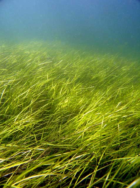
A seagrass meadow. (Christoffer Boström)
A seagrass meadow.
(Christoffer Boström)

Sea grasses form the backbone of one of the most productive and biodiverse ecosystems on Earth, rivaling coral reefs and rain forests in terms of the ecosystem services they provide to humans.

Sea grass meadows are part of the soft-sediment coastal ecosystems found in all continents, with the exception of Antarctica. They not only form a nursery for young fish and other organisms, but also protect the coastline from erosion and maintain water clarity. ‘

The study, which sequenced the genome of the eel grass taken from the Archipelago Sea off Finland. published today, in the journal Nature, is the work of an international consortium of 35 labs, most of them in Europe, working with researchers from the U.S. Department of Energy Joint Genome Institute.

The study showed that eel grasses are completely submerged marine flowering plants, called by science angiosperms. It shows that eel grass is a member of the ancient monocot family.

The monocots include about 60,000 species, flowering plants that first appear above the soil as a single leaf. They include orchids, “true grasses,” as well as rice, wheat, maize and “forage grasses” such as  sugar cane, and the bamboos. According to Wikipedia, other economically important monocot crops include  palms  bananas , gingers, onions, garlic, lilies, daffodils,  irises, amaryllis,  bluebells and tulips.

Zostera marina is the first marine flowering plant have its genome fully sequenced. As well as finding the eel grass’s genetic ancestors the researchers were interested in understanding how the plant–and by extension other plants in the ecosystem–adapt to climate change.

As it adapted to  an underwater, coastal lifestyle, eel grass gained genes that allowed it to live in saltwater but lost genes involved in traits associated with land-based plants.

Olsen called this “arguably the most extreme adaptation a terrestrial (and even a freshwater) species can undergo.”

What she describes as the “use it, lose it, or change it” scenario, eelgrass modified its cell walls. The eel grass cell wall is very different from normal plant cell walls and more like that of sea algae, similar to the cell in seaweeds. The eel grass has lost genes associated with light-sensing, pollination and regulation of internal water balance.

Eel grass lost its stomata (which are used by land plants to ‘breathe’) but also all of the genes involved in stomatal differentiation. “The genes have just gone, so there’s no way back to land for sea grass,” Olsen says. Sex is entirely underwater involving long naked sperm filaments especially adapted for underwater fertilization of the tiny flowers.

The team compared the eel grass genome to duck weed, one of the simplest flowering plants and Zostera marina’s closest sequenced relative. They noted differences in genes related to cell wall structure due to adaptations to freshwater or terrestrial conditions. For example, plants such as duckweed have seemingly lost genes that help plants retain water in the cell wall, while eel grass has regained these genes to better deal with osmotic stress at low tide.

“They have re-engineered themselves,” said Olsen of the changes affecting the eelgrass cell walls. “Crop breeders may benefit from lessons on how salt tolerance has evolved in these plants.”

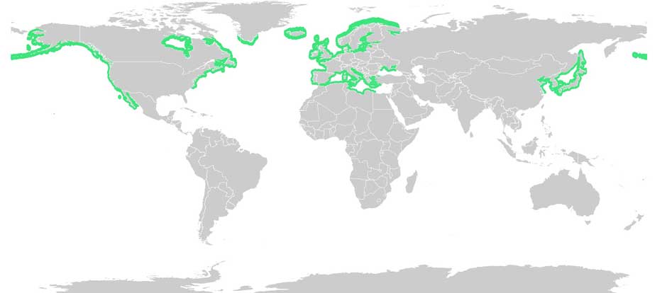
Eel grass distribution. (Wikipedia Commons(

With Zostera marina meadows stretching from Alaska to Baja California, and from the White Sea to southern Portugal, Olsen noted that these ecosystems afford researchers “a natural experiment to investigate rapid adaptation to warmer or colder waters, as well as to salinity tolerance, ocean acidification and light.”

Eel grass endangered

Jeremy Schmutz, head of the US Department of Energy’s genetic plant program, emphasized that while eel grasses are key players in coastal marine ecosystem functions and considered the “lungs of the sea,” they are also endangered. “There are estimates that nearly a third of the eel grass meadows worldwide have been destroyed by runoff into the ocean,” he said, “reducing their potential capabilities as carbon sinks. Thus, studying the adaptive capacity of eel grass is urgent to assist conservation efforts.”

An overarching question for Olsen’s team is how quickly eel grass can adapt to rapid climate change. The fact that Zostera marina grows along the coastline from Portugal to Scandinavia is being used as a natural experiment to investigate adaptation to warmer or colder water, as well as to salinity, ocean acidification and light.

Strange ancient hippo-like Pacific coast mammal “vacuumed” shoreline plant life

Scientists have identified a new species of a strange marine mammal group that lived on the Pacific Coast between 33 million years ago and 10 million years ago. The new specimens — from at least four individuals — were recovered from Unalaska, in theAleutians.

The Desmostylians, unlike other marine mammals species alive today — such as whales, seals and sea cows –are extinct. The researchers call them “desmos” for short. Unlike whales and seals, but like manatees, desmos were vegetarians

The desmos are found from Baja, California, up along the west coast of North America, around the Alaska Peninsula, the storm-battered Aleutian Islands, to Russia’s Kamchatka Peninsula and Sakhalin Island, to the Japanese islands

Their strange columnar teeth and odd style of eating don’t occur in any other mammal. They rooted around coastlines, ripping up vegetation, such as marine algae, sea grass and other near-shore plants.

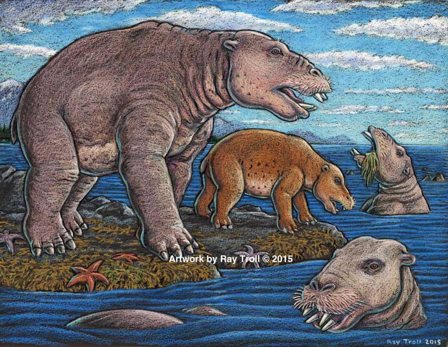
The new species, 23 million years old was a big, hippo-sized animal with a long snout and tusks, It has a unique tooth and jaw structure that indicates it was not only a vegetarian, but literally sucked vegetation from shorelines like a vacuum cleaner, said vertebrate paleontologist and study co-author Louis L. Jacobs, Southern Methodist University, Dallas.

They probably swam like polar bears, using their strong front limbs to power along. On land, they would have had the lumbering gait of a sloth.

A large, stocky-limbed mammal, desmos’ modern relatives remain a mystery. Scientists have previously linked the animals perhaps to manatees, horses or elephants. Adult desmostylians were large enough to be relatively safe from predators.

The identification of a new species belonging to Desmostylia has intensified the rare animal’s brief mysterious journey through prehistoric time, according to the new study.

While alive, the newly discovered creatures lived in what is now Unalaska’s Dutch Harbor.

“The new animal — when compared to one of a different species from Japan — made us realize that desmos do not chew like any other animal,” said Jacobs, a professor of earth sciences. “They clench their teeth, root up plants and suck them in.”

To eat, the animals buttressed their lower jaw with their teeth against the upper jaw, and used the powerful muscles that attached there, along with the shape of the roof of their mouth, to suction-feed vegetation from coastal bottoms. Big muscles in the neck would help to power their tusks, and big muscles in the throat would help with suction.

Discovery of the new genus and species that resembled a hippo and swam like a bear, from Unalaska indicates the desmostylian group was a successful group that was larger and more diverse than previously known. (Artist: Ray Troll)

“No other mammal eats like that,” Jacobs said. “The enamel rings on the teeth show wear and polish, but they don’t reveal consistent patterns related to habitual chewing motions.”

The new specimens also represent a new genus — meaning desmostylians in the same family diverged from one anoher in key physical characteristics, particularly the tooth and jaw structure, said Jacobs, who is one of 10 scientists collaborating on the research.

Discovery of a new genus and species indicates the desmostylian group was larger and more diverse than previously known, said paleontologist and co-author Anthony Fiorillo, vice president of research and collections and chief curator at the Perot Museum of Nature and Science, Dallas, and an adjunct research professor at SMU.

“Our new study shows that though this group of strange and extinct mammals was short-lived, it was a successful group with greater biodiversity than had been previously realized,” Fiorillo said.

Compared to other mammals, desmos were latecomers and didn’t appear on earth until fairly recently — 33 million years ago. Also unusual for mammals, they survived a mere 23 million years, dying out 10 million years ago.
The research was funded by the Perot Museum of Nature and Science, U.S. National Park Service – Alaska Region Office, and SMU’s Institute for the Study of Earth and Man.

The newest desmo made its home on Unalaska Island, the farthest north of any occurrence of the group, which only lived along the shores of the North Pacific.

“That’s the only place they’re known in the world,” Jacobs said. The Unalaska fossils represent at least four individuals, and one is a baby.

“The baby tells us they had a breeding population up there,” Jacobs said. “They must have stayed in sheltered areas to protect the young from surf and currents.”

In addition, “the baby also tells us that this area along the Alaska coast was biologically productive enough to make it a good place for raising a family,” said Fiorillo.

Just as cattle assemble in a herd, and a group of fish is a school, multiple desmostylians constitute a “troll” — a designation selected by Jacobs to honor Alaskan Ray Troll, the artist who has depicted desmos most.

The first Unalaska fossils were discovered in the 1950s in a rock quarry during U.S. Geological Survey mapping.

Others found more recently were on display at the Ounalashka Corporation headquarters. Those specimens were offered to Fiorillo and Jacobs for study after Fiorillo gave a public presentation to the community on his work in Alaska.

“The fruits of that lecture were that it started the networking with the community, which in turn led us to a small, but very important collection of fossils that had been unearthed in the town when they built a school a few years earlier,” Fiorillo said. “The fossils were shipped to the Perot Museum of Nature and Science for preparation in our lab and those fossils are the basis for our work now.”

From there, the researchers discovered that the fossils were a new genus and species.

The authors report their discoveries in a special volume of the international paleobiology journal, Historical Biology. The article published online Oct. 1 at http://bit.ly/1PQAHZJ

The researchers named the new mammal Ounalashkastylus tomidai. “Ounalashka,” means “near the peninsula” in the Aleut language of the indigenous people of the Aleutian Islands.

“Stylus” is from the Latin for “column” and refers to the shape of cusps in the teeth.

“Tomida” honors distinguished Japanese vertebrate paleontologist Yukimitsu Tomida.

The article appears in a special volume of Historical Biology to honor the career accomplishments of Tomida upon his retirement from the Department of Geology and Paleontology in Tokyo’s National Museum of Nature and Science.
In addition to Jacobs, Fiorillo and Polcyn, other authors were Yosuke Nishida, SMU; Yuri Kimura, Smithsonian Institution and the Tokyo Museum; Kentaro Chiba, University of Toronto; Yoshitsugu Kobayashi, Hokkaido University Museum, Naoki Kohno, National Museum of Nature and Science; and Kohei Tanaka, University of Calgary.

The Historical Biology article is titled “A new desmostylian mammal from Unalaska (USA) and the robust Sanjussen jaw from Hokkaido (Japan), with comments on feeding in derived desmostylids” and appears in the special issue “Contributions to vertebrate palaeontology in honour of Yukimitsu Tomida.”

“Very low levels” of Exxon Valdez oil threaten salmon and herring survival 25 years later

“Very low levels” of crude oil from the 1989 Exxon Valdez spill in Prince William Sound, Alaska, are a threat to the survival of herring and pink salmon that spawn in the region, according to a study released today by the US National Oceanic and Atmospheric Administration.

The study shows that embryonic salmon and herring exposed to very low levels of crude oil can develop hidden heart defects that compromise their later survival.

That means that the Exxon Valdez spill on March 24, 1989 may have had much greater impacts on spawning fish than previously recognized, according to the study published in  Nature’s online journal  Scientific Reports Very low embyronic crude oil exposures cause lasting defects in salmon and herring.

“These juvenile fish on the outside look completely normal, but their hearts are not functioning properly and that translates directly into reduced swimming ability and reduced survival,” said John Incardona, a research toxicologist at NOAA Fisheries’ Northwest Fisheries Science Center (NWFSC) in Seattle. “In terms of impacts to shore-spawning fish, the oil spill likely had a much bigger footprint than anyone realized.”

This is a juvenile pink salmon exposed to low levels of crude oil as an embryo. While these fish appear outwardly normal, they nevertheless developed heart defects that compromised their ability to swim. Fish that are less able to forage and avoid predators are much less likely to survive to adulthood. (NOAA)

Previous research has shown that crude oil disrupts the contraction of the fish heart muscle cells. Embryonic fish exposed to trace levels of crude oil grow into juveniles with abnormal hearts and reduced cardiorespiratory function.

“With this very early impact on the heart, you end up with an animal that just can’t pump blood through its body as well, which means it can’t swim as well to capture food, form schools, or migrate,” said Mark Carls, toxicologist at the Alaska Fisheries Science Center. “Crude oil is changing basic physiology, or what makes a fish a fish.”

The research builds on earlier work by the Auke Bay Laboratories, part of NOAA Fisheries’ Alaska Fisheries Science Center, which found much reduced survival of pink salmon exposed as embryos to polycyclic aromatic hydrocarbons (PAH) from crude oil.

“Our findings are changing the picture in terms of assessing the risk and the potential impacts of oil spills,” said Nat Scholz, leader of the NWFSC’s ecotoxicology program and a coauthor of the new study. “We now know the developing fish heart is exquisitely sensitive to crude oil toxicity, and that subtle changes in heart formation can have delayed but important consequences for first-year survival, which in turn determines the long-term abundance of wild fish populations.”

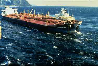
The Exxon Valdez aground on Bligh Reef in Prince William Sound in May 1989. (NOAA)
The Exxon Valdez aground on Bligh Reef in Prince William Sound in March 1989. (NOAA)

The Exxon Valdez spill was the largest in U.S. history, with extensive oiling of shoreline spawning habitats for Pacific herring and pink salmon, the two most important commercial fish species in Prince William Sound.

Herring larvae sampled in proximity to oil were visibly abnormal, and mortality rates were higher for pink salmon embryos at oil spill sites than unaffected regions.

The herring fishery collapsed three to four years after the spill, when the herring spawned in oiled areas reached reproductive maturity.

The paper notes that the contribution of the spill to the herring population collapse, if any, was never determined and remains controversial.

Other studies, however, tend to confirm the findings, including heart problems for fish exposed to the Gulf of Mexico Deepwater Horizon spill and even fish exposed to naturally occurring oil seeps.

Oil spill caused unexpected lethal impact on herring, study shows

Gulf oil spill caused heart defects in fish embryos new study finds

The new findings suggest that the delayed effects of the spill may have been important contributors to the declines.

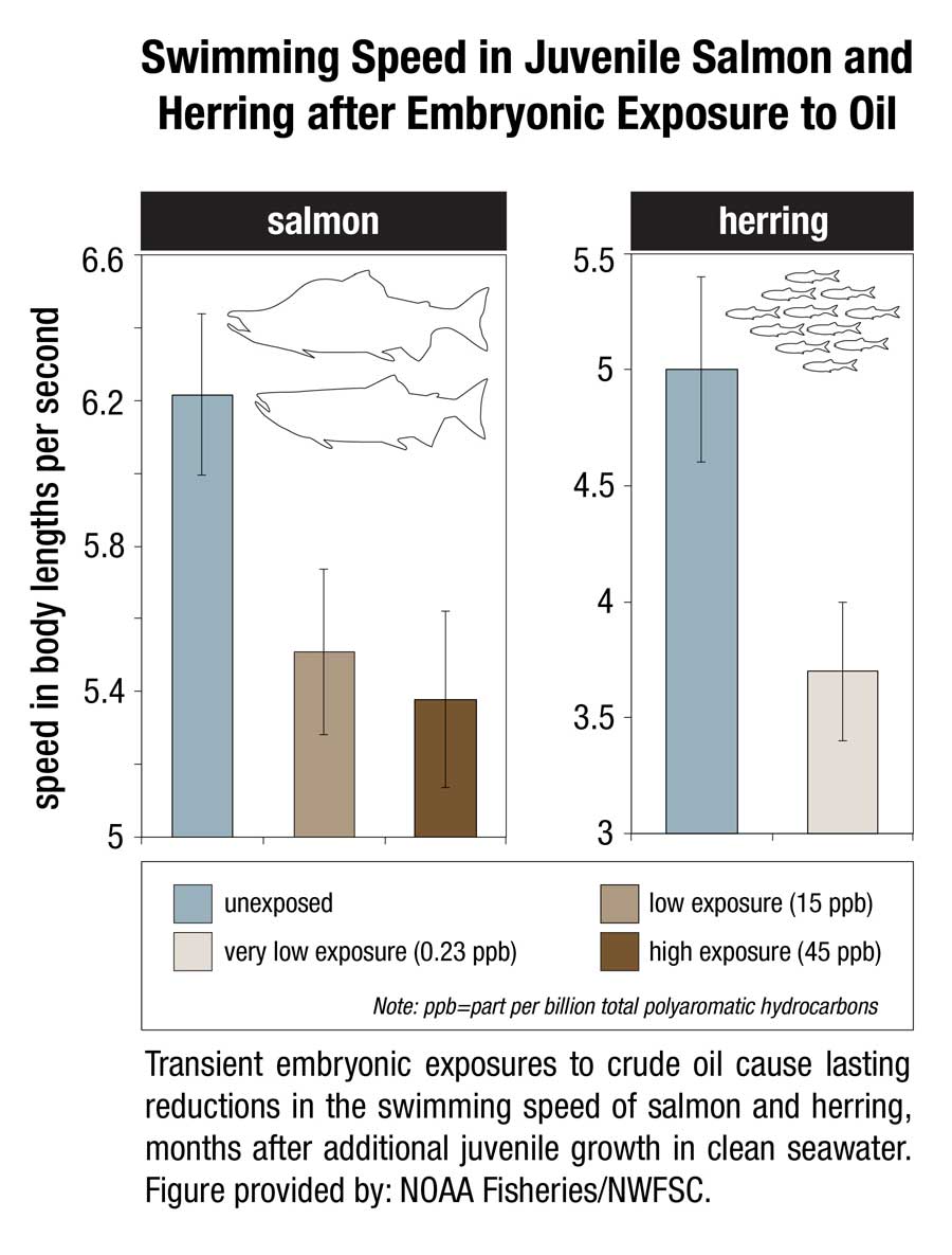
 This image shows transient embryonic exposures to crude oil cause lasting reductions in the swimming speed of salmon and herring, months after additional juvenile growth in clean seawater. (NOAA)

This image shows transient embryonic exposures to crude oil cause lasting reductions in the swimming speed of salmon and herring, months after additional juvenile growth in clean seawater. (NOAA)

Scientists from the Northwest Fisheries Science Center and Alaska Fisheries Science Center temporarily exposed embryonic salmon and herring to low levels of crude oil from the North Slope of Alaska and found that both absorbed chemicals at similar concentrations in their tissues. The embryos were then transferred to clean seawater and raised as juvenile fish for seven to eight months.

Few of the exposed embryos were outwardly abnormal in any way. However, closer examination of the fish revealed subtle defects that could reduce their long-term survival.

Juvenile salmon exposed to oil grew more slowly, with those exposed to the highest concentrations growing the slowest. For salmon, early survival in the ocean is strongly influenced by juvenile growth, with smaller fish suffering higher loss to predators.

Scientists used swimming speed as a measure of cardiorespiratory performance and found that fish exposed to the highest concentrations of oil swam the slowest. Slower swimming is an indication of reduced aerobic capacity and cardiac output, and likely makes fish easier targets for predators.

Exposure to oil as embryos altered the structural development of the hearts of juvenile fish, potentially reducing their fitness and swimming ability. Poor swimming and cardiac fitness is also a factor in disease resistance.

Earlier studies on the ecosystem-scale crash of the Prince William Sound herring population  several years after the Exxon Valdez spill were based on higher levels of exposure to the oil. The new study shows that that cardiac injury occurs in normal-appearing fish that survive even lower level exposures.

The scientists reviewed data on measured oil concentrations in surface water samples collected in Prince William Sound after the oil spill and during the 1989 herring spawning season. Most of the 233 samples contained less oil than was believed to be toxic to herring at the time, based on visible gross developmental abnormalities. However, nearly all of the samples contained oil at or above concentrations shown in the new study to alter heart development.

If the Exxon Valdez spill impacted heart development among a large majority of fish that were spawned in proximity to oiled shorelines, the subsequent losses of juveniles to delayed mortality would have left fewer adults to join the population. Although not direct proof, this provides a plausible explanation for the collapse of the Prince William Sound herring stock four years later, when fish spawned during the oil spill would have matured.

The study concludes that the impacts of the Exxon Valdez spill on near shore spawning populations of fish are likely to have been considerably underestimated in terms of both the geographic extent of affected habitat and the lingering toxicity of low levels of oil. The findings will likely contribute to more accurate assessments of the impacts of future oil spills, Incardona said. “Now we have a much better idea of what we should be looking for,” he said.

That means, according to the study “that the impacts of the Exxon Valdez oil spill on populations of near shore spawning fish are likely to have been considerably underestimated, in term of both the geographic extent of affected habitats and the lingering toxicity of low levels of residual oil.”

The report calls for more studies of the sensitivity of the developing fish heart since the vulnerability “also has implications for other pollution sources in marine ecosystems, including increasing maritime vessel traffic and expanding land-based urban runoff.”

In 2013, the Northern Gateway Joint Review panel said this about the Exxon Valdez  oil spill.

Scientific studies after the Exxon Valdez spill indicated that the vast majority of species recovered following the spill and that functioning ecosystems, similar to those existing pre-spill, were established.

Species for which recovery is not fully apparent, such as Pacific herring, killer whales, and pigeon guillemots, appear to have been affected by other environmental factors or human influences not associated with the oil spill. Insufficient pre-spill baseline data on these species contributed to difficulties in determining the extent of spill effects.

Based on the evidence, the Panel finds that natural recovery of the aquatic environment after an oil spill is likely to be the primary recovery mechanism, particularly for marine spills. Both freshwater and marine ecosystem recovery is further mitigated where cleanup is possible, effective, and beneficial to the environment.

Natural processes that degrade oil would begin immediately following a spill. Although residual oil could remain buried in sediments for years, the Panel finds that toxicity associated with that oil would decline over time and would not cause widespread, long-term impacts.

Related

25th anniversary of Exxon Valdez disaster looms over Northern Gateway dispute