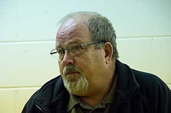
Kitimat Emergency Coordinator Bob McLeod at the earthquake postmortem Oct. 29, 2012 (Robin Rowland/Northwest Coast Energy News)
Studies of the October 2012 magnitude 7.8 Haida Gwaii earthquake show that the region is vulnerable to a “major megathrust” earthquake along a newly confirmed fault line west of the islands.
That earthquake was felt in Kitimat and Kitamaat Village and a tsunami warning was issued within a few minutes.
So have the District of Kitimat, the Haisla Nation Council or Rio Tinto Alcan changed or upgrading their earthquake and tsunami plans in the past couple of years?
Bob McLeod, who recently retired as the District of Kitimat’s emergency coordinator, told Northwest Coast Energy News: “I think we’ve done quite a bit. One of the biggest issues in the first one was trying to get information out. We’ve come a long way on that. Whether you reach everyone or not, that’s another thing, because you never reach everybody. One of the critical things to me is getting the information out so you avoid all this Facebook, Twitter speculating and rumour. The communications aspect has improved a hundred fold.
“We did more work on the mapping and planning. Over the course of the last year, there were a lot of meetings with industry and various stakeholders, discussing emergency preparedness in general but touching on some of these other things as well.
“One of the things we did was to try to set up some shelter points. We have an agreement with the Baptist Church, the Catholic Church and the Seventh Day Adventists. They’re strategically located and could be gathering points for the various neighborhoods if necessary.
“We’ve also done quite a lot of work on Riverlodge as a group lodging centre, thinking in terms of an earthquake where there may be damage and you have to move people.
“We did look at the evacuation planning and we’ve had a couple of exercises involving that, looking strategically about how can you move people from certain neighborhoods, asking which neighborhoods would be at the most risk if you ended up with a tsunami situation.
As for tsunamis, McLeod said, “From everything we’ve heard and been told, tsunamis in extremely deep water like that is not going to be as dangerous as one in shallower water, but the possibility is still there.
“The thrusts are the killers when it comes to tsunamis, but there is a very good warning system on the tsunamis. We do get very very rapid feedback on the earthquakes.
“The only danger in that regard is if you have a severe earthquake and you have part of a mountain drop into the salt chuck, you’re going to get a massive wave and you’re going to get no warning whatsoever, like the Moon Bay collapse in the seventies.
“The emergency plan is in good shape. We scheduled a number of exercises last year through training programs.
“One of the things I personally push is personal preparedness. I think as a community, we fail greatly at that. That was evident even during the snowstorm. People are not just prepared to look after themselves, it’s unfortunate. You just have to keep chipping away.”
Last week, Northwest Coast Energy News asked Rio Tinto Alcan and the Haisla Nation Council if either could comment on updated earthquake or tsunami response plans. So we have received no answers.
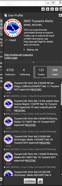
For the past month, text message tsunami warnings from the West Coast and Alaska Tsunami Warning Center have transformed from clear, concise vital information to incomprehensible computer code with a link to a useless URL–at least on my Bell Android Samsung phone.
Take the warning for this morning’s 4.7 magnitude earthquake which shook southern California. The Los Angeles Times is now reporting there have been more than 100 aftershocks from the quake.
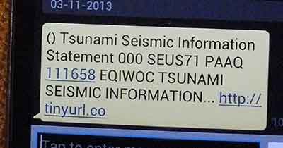
My phone beeped this morning with the tone that let me know that this was a possible tsunami warning.
This is what appeared on my phone.
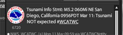
This is what appeared on my Tweetdeck feed.
The SMS text message is completely useless. Not only is there no vital information, it directs you to tinyurl.co, which (if the URL is not truncated) usually reaches the homepage for the Tiny URL website. On other times clicking on a link goes to a spam like, buy this domain site, tinyurl.co which is even worse.
I began subscribing to the WCATWC warning messages on my phone the day after the October 27, 2012 earthquake on Haida Gwaii.
From October until mid-February, the messages on Twitter and on my phone were identical. Then in February everything changed, perhaps because NOAA, the US National Oceanic and Atmospheric Administration, changed the transmission servers. Although it is not clear why simply changing a the outgoing server would have any affect on a message that the US and Canadian federal governments and the state and provincial governments along the west coast consider vital public information.
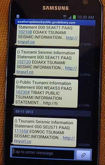
Here are the latest messages as they appeared on my phone.
Here is how the same warnings appeared on Tweetdeck.
According to my phone’s text message log, the last clear message about a possible tsunami was received on February 14 from the server nws.noaa@service.govdelivery.com. All the gobbledygook messages since then have come from weatherupdates@public.govdelivery.com.
Here is how the tsunami warnings appeared on my phone prior to the server change on Feb. 14.
A spokesperson for the tsunami warning center could not be reached for comment.
Related issue: The death of Tweetdeck
A somewhat related issue to the failure of the SMS messages from the tsunami warning center is Twitter’s (in my view completely stupid) decision last week to kill Tweetdeck for the Android and Apple phones.
I have always followed earthquake and tsunami warnings (as well as other breaking news stories) using Tweetdeck for both my desktop and my phone.
For the past month, as soon as I’ve heard the tsunami alert on my phone, I have gone straight to Tweetdeck, ignoring the bad text message.
Twitter which bought Tweetdeck last year, now wants to force users to their own mobile apps and to use the Chrome version on the desktop.
Frankly, the Twitter app for the Android was and is awful which is why I kept using Tweetdeck and will do so until Tweetdeck is killed by Twitter. I do use the Twitter app for my iPad and I don’t like it either. Unlike Tweetdeck, neither app has the flexibility that I require as a journalist. With Tweetdeck, even on a phone, you can call up specific topics quickly and switch back and forth.
Twitter says
discontinuing our app support is a reflection of where our TweetDeck power-users are going. Over the past few years, we’ve seen a steady trend towards people using TweetDeck on their computers and Twitter on their mobile devices.
I have to wonder what kind of power users Twitter is referring to. Many journalists (and activists and politicians) reacted to the decision with horror.
There is speculation that Twitter, which has to make money, of course, wants to drive users to its own apps so it can load advertising on the feed. That’s a legitimate business decision.
For years, Tweetdeck has been the go to software for tracking emergencies and breaking news. One has to wonder if any of the California-based employees of Twitter got the same garbled text message that I got and where they went to get better information.
The real test of Twitter’s programs will not how much they are used for gossip, but how they work in an emergency or a disaster.
The Harper government is stalling on requests for better earthquake preparation on Haida Gwaii, according to the NDP MP for Skeena Bulkley Valley, Nathan Cullen.
Speaking to northwest reporters on Thursday, February 28, Cullen who is NDP House Leader, said: “The government has been stalling since November when we’ve been asking them to meet the communities and meet their demands for funding, because as we see more earthquakes come, the support hasn’t been there from the federal government.”
“The communities have done their work,” Cullen said. “We’ve given the government three months now. Earthquakes continue to still happen,
“Rather than shedding tears if something goes wrong, the government should fix the problems. We know exactly where the funding can be coordinated and effective particularly in Haida Gwaii, there’s been a lot of work done on behalf of their communities especially by their municipal leaders.
“The federal government simply has to say yes, to meet with them, to find some of those funding solutions. This is not rocket science.
“Maybe because there aren’t earthquakes in Ottawa, the Harper government doesn’t seem to think these things are a concern to people. But they are. And let’s not wait until a tragedy happens before we start to make some moves.”
Cullen noted that the federal government had recently budgeted $680,000 for new LED lights for the communities on Haida Gwaii.
“I am not going to speak against the need to put LED lights in but’s obvious that the federal government’s priorities are not aligned with what’s actually needed on the ground. People have been calling for this for years. We’ve seen tsunami warnings before. And there’s some good and reasonable fixes.
“The role of the federal government emergency preparedness requires this,” Cullen said, but then he added that, “Now one thing to keep in mind is that this federal conservative government wants to get out of anything to do with emergency readiness and response,” pointing to cutbacks in the budget for First Nations police forces.
Unmentioned at the news conference was that likely also includes the Coast Guard cutbacks on the west including, including the highly unpopular and controversial closing of the Kitsalano Coast Guard base in Vancouver
Cullen said he was hoping to meet with the cabinet ministers responsible to get more action on earthquake readiness on Haida Gwaii.
EmergencyInfoBC Please be advised that @EmergencyInfoBC is the only authorized emergency alert feed for Gov’t of BC.
Tweet Thu 8 Nov 11 48
The British Columbia Solicitor General’s department is asking northwest municipalities to “clarify the initial response actions” to the October 27 2012, magnitude 7.7 earthquake off Haida Gwaii and the resulting tsunami warning.
A covering letter to municipalities from Lori Wannamaker BC Deputy Solicitor General says the province is reviewing the response to the earthquake and tsunami and is “seeking input from affected community leaders.” The package includes a letter sent to Emergency Program Coordinators across British Columbia, adding: “Input will be sought in an endeavour to hear from those directly impacted as a measure of enhancing our operations and response,” adding. “Events like present all levels of government with a learning opportunity.”
In the main letter to the municipalities outlining emergency procedures, the department also offers a time line of its response to the incident.
Clarify the initial response actions
The package sent to municipalities by Rebecca Derlinger, Assistant Deputy Minister /Fire and Emergency Management Coordinator, opens by saying: “The earthquake/tsunami event on October 27, 2012 demonstrated the high level of emergency preparedness that has been undertaken by local governments in BC. Elected officials and emergency managers in all impacted communities deserve praise for a timely and effective response that was undertaken, including evacuations.”
But in the next paragraph the letter goes on to say: “Prior to the completion of the provincial debrief process, we would like to clarify the initial response actions of local government emergency management personnel including how information should be managed after an earthquake that impacts BC.”
The letter also says that “Local governments must complete a hazard risk and vulnerability analysis for their communities according to the Emergency Program Act and regulations, keeping in mind that all parts of British Columbia have a risk of earthquake impacts. Coastal communities have the added risk of tsunami.”
The letter then outlines three scenarios for various communities
Significant earthquake is felt in a community located in an area with tsunami risk
Earthquake is not felt, however, a community is located in an area with tsunami risk (teletsunami)
Earthquake is felt in a community that is not located in area that has tsunami risk
In all three scenarios it says Emergency Management BC “will provide the general public with ongoing situational awareness through:
EmergencyInfoBC blogsite
Social media such as Twitter
Mainstream media (press conferences and releases)
For areas such as Kitimat, which is in a possible tsunami zone, the letter advises “Local governments should undertake the following emergency response activities immediately following a significant earthquake (do not wait for official notification)
Activate their local emergency response plans and if deemed necessary
Active local first responders
Undertake public alerting and initiate evacuations of low lying areas
Open an emergency operations centre in a safe location
Report to EMBC
Ensure ongoing public messaging to their citizens
Gather information to develop situational awareness
For areas that don’t feel the earthquake, the province recommends
Local governments should undertake…emergency response activities immediately following the receipt of a West Coast Alaska Tsunami Warning Centre (or WCATTWC) and/or EMBC notification of a potential tsunami event. It then calls on local emergency officials to follow the same procedure outlined above “if a notification indicates an increased risk of a tsunami (warning or advisory only)
As you can see from the Twitter profile, Emergency Info BC works during normal office hours, Monday to Friday unless there is a declared emergency
The warnings October 27
In the letter the province outlines a time line of how the emergency system worked on October 27.
It says the provincial Tsunami Notification plan was activated at 8:10 pm. October 27, approximately four minutes after the earthquake.
In a provincial acronym soup it then says
The EMBC (Emergency Management BC) Emergency Coordination Centre initiated an internal resource request to activate the PECC (Provincial Emergency Coordination Centre) and the PREOCs (Provincial Regional Operations Centres).
EMBC and Temporary Emergency Assignment Management System (TEAMS) staff were in attendance at PECC and PREOCs by 8:33 pm.
“Based on the initial bulletin from WCATTWC, social media staff sent out a message via Twitter” at 8:48 pm At that time EMBC regional offices began contacting communities with potential tsunami risk by telephone. “Subject matter experts from Natural Resources Canada and Canadian Hydrographic Service were contacted by PECC at 8:30 pm and at 9 pm to review the information received from WCATWC.
“Based on these discussions, the PENS (Provincial Emergency Notification) was initiated at 9:05 while efforts to make contact with those communities under tsunami warning continued.
At 10:45 pm a media conference call was held by the Minister of Justice.
The letter continues to say that conference calls were held with EMBC, US state emergency management offices, and the West Coast Alaska Tsunami Warning Centre hourly until the final cancellation of the west coast warning by WCATWC at 2:47 am Sunday morning and by the province at 3:03 am
It concludes “Staff responsible for social media were actively engaged in informing the public.”
Denlinger’s letter then goes on to note that the provincial debrief will include “a discussion on the information flow from the province to emergency management stakeholders and the public (for example the use of social media as a communications tool for public awareness of the event)… This information….will assist in the creation of a provincial after action report and in the enhancement of subsequent provincial earthquake and tsunami response plans.”
At 6:06 I received an automatic text message from the West Coast Alaska Tsunami Warning Centre
Tsunami Info Stmt: M6.3 085Mi SW Port Alice, British Columbia 1802PST Nov 7: Tsunami NOT expected #WCATWC
At 6:07 I received an automatic tweet from Canadaquakes : @CANADAquakes: Automatic detection of seismic event: magnitude 4.4 – 7 Nov 18:01 PST – PORT HARDY, BC region
At 6:15, I received the WCATWC message on Twitter that I had received 9 minutes earlier via text
Tsunami Info Stmt: M6.3 085Mi SW Port Alice, British Columbia 1802PST Nov 7: Tsunami NOT expected #WCATWC
@EmergencyInfoBC retweets the WCATWC message
At 6:27 Canada quakes updated their tweet with corrected information: @CANADAquakes: EARTHQUAKE Mag=6.3 on 07 Nov at 18:01 PST. Details : http://t.co/OL9RTPKC 101 km SSW of Port Alice, BC
@EmergencyInfoBC retweets the CANADAquakes message
Analysis The province didn’t get it
Read between the lines of the Solicitor General’s letter and a couple of things stand out. While at first the officials say things went fine according to procedures in the book, events appear to show that in practice, the system didn’t work as well as expected on the night of October 27.
First the province, reminds municipalities of that they “must complete a hazard risk and vulnerability analysis for the communities.”
Second, while EM BC social media staff were, according to the letter, “were actively engaged in informing the public,” there was actually scant evidence of that during the crucial first 90 minutes after the earthquake on Haida Gwaii. While the emergency coordination officials and bureaucrats apparently were well informed about what was happening, the public was not. As I pointed out in an earlier post, differences between the US and Canadian warning systems contributed to the confusion. As well there was a problem on both Twitter and Facebook of rumour, misleading and false information being posted on social media during that crucial 90 minutes.
The line about the “the use of social media as a communications tool for public awareness of the event” is a clear indication that not all went well with the EM BC Twitter feed the night of the Haida Gwaii earthquake.
While Emergency Info BC is a sort of blog, again you have to know to go there and it is only active during an emergency. There were no posting on the night of the earthquake and tsunami. The last “blog” was during the Johnson’s Landing landslide evacuation in July 2012, and even that doesn’t give much information. Looks like Emergency Info doesn’t understand that a blog entry that says “no danger, nothing much is happening” is just as important as evacuation instructions.
The main website is Emergency Management BC, with a link to the Info site—if there is an emergency—not exactly a prime example of web design for someone in a hurry, whether an official, the media or the public, since it was what the web calls “brochure ware.”
The first indication of whether or not there would be major danger to the BC coast on Oct. 27 was at Langara Island at 9:16 pm. Local officials in northwest BC were monitoring Langara and the relatively low surge indicated–at least at that time– that danger was not as great as feared. Yet it was only seven minutes earlier that EM BC activated the Provincial Notification Program at 9:05, and that was an hour after it was known that the earthquake was 7.7 in magnitude, which had the potential for catastrophic damage. The tweets that I saw about the small surge at Langara, came from Prince Rupert. It is in a situation like the Langara monitoring that the Emergency Info blog would have been relevant.
The need for constant official updates is clear. Earthquakes do not work 8:30 to 4:30, Monday to Friday. The province has to be able to activate emergency notification much faster. If a web journalist whether working for the mainstream media or a responsible individual on a small site can tweet or post in seconds, usually working from a home office or even a smart phone, emergency officials can do the same.
In these days, travel by government officials is often frowned upon. A couple of months from now, when New York and New Jersey have recovered from the Superstorm Sandy and this weeks Nor’easter, a visit from BC emergency officials is in order to see how it is done.
As a 7.7 magnitude earthquake hit off Haida Gwaii shortly after eight o’clock on Saturday, I was at the Haisla Recreation Centre as the Haisla Nation marked the return of the G’ps Golox totem pole. Like a boat being lifted by gentle waves, the Rec Centre began to quietly roll up and down, then the rolling seemed to accelerate just a bit. I realized that it was an earthquake. As I told CBC’s Ian Hanomansing later in the evening, I have been in a number of earthquakes, and for me at least, this quake, at least at Kitamaat Village, the rec centre was not shaking as badly as in some of the others I have felt.
The subsequent events of the evening show that the emergency communication system in Kitimat needs immediate improvement.
Now as a former network producer for both CBC and CTV I have handled a large number of earthquake stories from around the world over the past quarter century (sitting at a desk, I should add). With that experience, I was hoping to get a cell hit at the village so I could bring up Twitter. I already subscribe to the US Geological Survey and Canadian earthquake alert feeds. The US and Canadian computers automatically report earthquakes within seconds of detection and send out a Twitter bulletin as the same time as those computers are alerting their human masters. If I had been able to get cell service I would have known within minutes that the Haida Gwaii earthquake was a major event. (I did follow the alerts from my computer once I got back to Kitimat itself).
Recommendation One. Cell service in Kitimat, Kitamaat Village, the harbour area must be upgraded as soon as possible. Telus has applied to council to erect a new cell tower here. Given the events of the past 24 hours, District Council should make sure that all parts of the District of Kitimat and the Haisla Nation have proper cell coverage no matter what service one subscribes to, not just for the convenience of subscribers but for emergency situations.
Automatic alerts
With experience one knows that in a situation such as Saturday night, the official websites such as the US Geological Survey and the Pacific Tsunami Warning Center as well as Natural Resources Canada are often overwhelmed. That is why the media use RSS feeds, Twitter feeds and e-mail alerts. It is also important to realize that these emergency organizations have their own language and procedures. It appears that a lot of the confusion on Saturday came from misinterpretation of the various Canadian and US warning systems.
Recommendation Two. If Kitimat emergency services are not familiar with how the US based earthquake and tsunami centres work, they should be trained in those systems, simply because the Americans are well ahead of Canada in these areas because the alerts go out by computer automatically and are constantly updated and as Saturday night showed, are often quicker and farther ahead than the Canadian systems.
Once I was back in Kitimat, it was clear that communications were breaking down, and this was at a time the tsunami warning was still active. There were numerous messages on Twitter and Facebook, from residents of Kitimat either trying to find out what was going on or retweeting/reposting rumours including one that the Kildala neighbourhood was being evacuated. I am told that residents were calling the RCMP to ask what was going on. This was another breakdown since North District HQ in Prince George handles all police services in this region and were likely busy with quake calls on Haida Gwaii, so that information calls in Kitimat that should have been handled by an emergency services public communications person were being handled the Mounties.
There were reports that one man was going door to door in Kildala telling people to evacuate. Whether this person was well intentioned but misinformed or a imposter intent on mischief doesn’t matter, there was an information vacuum.
It was clear from Twitter that other districts and municipalities were using that service to spread official information. (I don’t follow other areas on Facebook so it is unclear if information was being posted on Facebook. There was certainly no official presence from Kitimat on Facebook Saturday night.) It appears from reports in the Kitimat Daily and tweets about the Northern Sentinel that Kitimat emergency services was sending information out by fax. While faxing information was an advance in the 1980s, faxes are obsolete in 2012. Many major newsrooms no longer use fax machines after being inundated by junk faxes and after they laid off all the editorial assistants who would have cleared those fax machines (even by the late 90s most faxes were dumped in the garbage unless the EA had been told to look for a specific fax). Also though it is now more than two years since I returned to Kitimat and I regularly freelance for Global, CBC and Canadian Press, I had no contact from anyone in emergency services (also I don’t have a fax machine).
Recommendation Three: The District of Kitimat must immediately bring its emergency communications into the 21st century, with Twitter accounts, a Facebook page and an emergency e-mail or text message plan for media and other officials who can get the messages. ( A number of jurisdictions already use text messages for emergency alerts at various graduated levels, official, media, public). When the main means of communication today is social media, an emergency organization can no longer follow outdated procedures, an organization must be on social media immediately it becomes clear that there is an emergency (as we are seeing with all the official tweets with the Hurricane Sandy crisis on the east coast)
CFTK
In an emergency situation, local radio and television are vital to communications and letting people know what is going on.
The inadequate coverage of the quake was certainly not the fault the of the current CFTK news staff who were working hard (probably on their own time and unpaid) keeping Twitter updated with what they knew. The fault lies with corporate management across the media which these days doesn’t want to spend the money and resources and training to fulfill the public service portion of their broadcast licence mandate.
(There was a similar breakdown in the May 2000, Walkerton, Ontario e-coli crisis where the local medical officer of health was initially unable to alert the public because local radio wasn’t staffed on the weekends–the local stations were taking satellite feeds from their corporate headquarters)
In 1964, long before satellites, when the microwave towers that joined CFTK to the Canadian networks were still being built, the staff of CFTK, then, of course under local management, went to a live special within an hour of the Anchorage quake being felt far off from Alaska in Kitimat. The CFTK anchors were keeping its audience updated with “rip and read” wire copy, a camera on an atlas for a map and phone interviews.
In contrast, on this Saturday night, CFTK was taking the CBC BC network feed which was a hockey rerun (hardly a show that attracts major audience numbers and certainly not a vital broadcast) until the CBC management in Vancouver decided to go to full network news special.
Since CFTK is the station that broadcasts not only to Kitimat, but to Haida Gwaii as well, CFTK should have been ahead of Vancouver on this story, called in its staff and mounted their own live special, joining the CBC feed when it began but, as on an election night, breaking away for local news when justified. CFTK has a responsibility under its licence from the CRTC to provide that service to the northwestern region, not just sending what ad revenue it generates back to Astral.
Rio Tinto Alcan
Another question that must be asked in this situation is where was Rio Tinto Alcan on Saturday night? In all areas that were under a tsunami warning the first scrutiny and clue if there was to be a problem is that region would be found by observing what has happening between the low tide line and the maximum hide tide line. In Prince Rupert, from the Twitter feeds I saw, public officials were monitoring the waterfront and the tide lines and updating the public. RTA has all the advantages of the private port of Kitimat. It appears that monitoring the water level at the tide lines at the port of Kitimat was the responsibility of Plant Protection. Was RTA communicating what was happening with emergency services? Since RTA runs the private port, unlike in other jurisdictions, RTA had a responsibility to the people of Kitimat to report promptly to the public the conditions on the waterfront. Corporate public relations cannot just be sending out news releases with “good news.” That means that RTA public relations should have used its corporate Twitter account which usually sends out a news release every few weeks, to keep Kitimat updated on a minute-by-minute basis. If RTA communications staff in Kitimat do not have access to the RTA corporate Twitter account, they should establish their own local Twitter feed.
Both in 1964 and in 2012, the tsunami that came up Douglas Channel was minimal. But we know that this region does have a record of major quakes and that Douglas Channel has also experienced major landslides that can, in some circumstances, trigger a tsunami without an earthquake. The next few years will be seeing more industrial development along Douglas Channel which can also bring other hazards to the Kitimat region. While there are always communications breakdowns in situations like happened on Saturday, it is clear that the Kitimat emergency communications system needs a major upgrade to make sure the public is informed quickly and accurately of what is going on.
Enbridge made its strongest public case yet Tuesday, March 13, that improvements in marine safety worldwide since the Exxon Valdez disaster in 1989, make the chances of an accident involving ships carrying bitumen and condensate in Douglas Channel and the BC Coast highly unlikely.
But one of Enbridge’s own invited experts somewhat undermined the case by pointing out that in the event of a major tanker incident (as unlikely as Enbridge believes it may be) the resources of the federal and provincial governments are spread far too thin to deal with a major disaster.
The Enbridge Community Advisory Board held a public meeting Tuesday at Mt. Elizabeth Theatre, with three guests presenting a case that they also gave to the regular meeting of the advisory board earlier in the day.
The three guests were Capt. Stephen Brown, of the BC Chamber of Shipping, Capt. Fred Denning, of British Columbia Coast Pilots and Norm Fallows, an emergency response officer with the BC Ministry of the Environment, based in Smithers.
There were only a few dozen people in the theatre for the presentation, compared the full house for last year’s community forum that was sponsored by the District of Kitimat. One reason may be that many Kitimat residents preferred being in the stands for the Coy Cup hockey championships at Tamitik Arena rather than sitting through yet another presentation on the Northern Gateway pipeline.
Denning opened the presentations by explaining the role of the BC Coast Pilots. The BC Coast Pilots is a private firm that contracts with government’s Pacific Pilotage Authority to provide pilots to ships plying the coast of British Columbia. By law all vessels larger than 350 gross registered tonnes are required to use a marine pilot.
Both in his presentation and in the question and answer period, Denning stressed that pilots are traditionally independent from government and industry, with the responsibility to ensure the safety of shipping.
In the question and answer period, when an audience member pointed out that under the Transport Canada TERMPOL process, use of tugs in Douglas Channel and use of tethered tugs was “voluntary,” Denning replied that the pilots would be insisting on tethered escort tugs for tankers on Douglas Channel.
He explained that BC pilots are highly experienced mariners, usually with 25 years or more experience on the coast, the majority of that time as a ship’s officer. An applicant to become a pilot is put on a waiting list, and if accepted, then is trained both on ships and simulators and serves a six to 12 month apprenticeship.
He said that BC coastal pilots have a 99.89 per cent incident safety record.
BC pilots now carry a large laptop called a Portable Pilot Unit, which operates independent of the ship’s navigation and computer systems gathering navigation and other data, as a redundant safety system.
Denning expects that marine traffic on the BC coast will continue to increase because the ports of Vancouver and Prince Rupert are the closest to Asia by the Great Circle routes. Both cargo and the energy projects, whether the Enbridge Northern Gateway or the the liquified natural gas terminals will mean more ships and more work for the pilots.
The pilots are always consulted in the development of any new traffic or terminal projects in BC. Including design, testing the ship’s courses in simulators, recommending new navigational aides and training for the pilots. Pilots were consulted during the development of Deltaport and Fairiew container terminals as well as the cruise ship terminals in Victoria, Nanaimo and Campbell River.
The pilots are being consulted on both the Enbridge and LNG projects at Kitimat as well as the proposed expansion of the Kinder Morgan facility in Vancouver. For the existing Kinder Morgan terminal, pilots were involved in creating navigation aides and tug procedures for the Second Narrows.
Stephen Brown is a member of the Community Advisory Board as well as representing the Bureau of Shipping. He began with a detailed timeline of how shipping regulations have been tightened over the years since what is now the International Maritime Organization, a United Nations agency, was founded in 1948. He said the Exxon Valdez accident in 1989 triggered even tighter regulations, including the 1990 US Oil Pollution Act passed by Congress which required all ships have containment capability and a spill clean up plan. The act also ordered US shippers to phase out single hulled tankers beginning in 1995. In 1992, the IMO adopted a similar measure.
Since the 1990s, there have been new regulations preventing the dumping of ballast and creating higher standards for crew and officer training, including hours of work, watch keeping standards and environmental awareness.
Brown then went on to discuss shipping in narrow waterways which he said were similar to Douglas Channel, including the Straits of Dover between Britain and France, the Straits of Malacca between Singapore and Malaysia and the island of Sumatra, the Dardanelles and Bosporus Strait in Turkey (which traditionally are said to join Europe with Asia) and the Panama Canal. All those areas, he said, see heavy shipping traffic, including tankers, each year.
The narrowest passage is in the Bosporus, which is 698 metres wide, a little less than one half nautical mile.
Comparing the Bosporus with Douglas Channel, Brown said Douglas Channel is much wider, about three kilometres, meaning that inbound and outbound ships can pass a half kilometre apart.
He went over how tanker management has improved with double hulls and better overall construction standards,vetting of ships and crews, and creating “a culture of safety and respect for the environment.”
The final speaker Norm Fallows, from the BC Ministry of the Environment Emergency Management, outlined the current emergency response system in the province. Central to any response to a oil spill or any other hazard materials problem is the “incident command system.” also used most often for fighting forest fires. The incident command system ensures that all public agencies and the private sector are cooperating and coordinating with one overall person in charge.
The province has a “polluter pay” policy, Fallows said, meaning that the “responsible party” must pay for all the cost involved. Sometimes, int he case of a meth lab, it is the unfortunate owner of a house that may have been rented by drug dealers.
Fallows said he is one of only 10 emergency response officers stationed across the province of British Columbia, In contrast, the State of Washington, with a much smaller land area than BC, has 79.
Any response to a spill has to do the best possible in the situation, Fallows said. He gave the example of burning off an oil spill in some circumstances because that was both the most cost effective solution that at the same time in those circumstances did the least harm to the environment.
In the early part of the first decade, Fallows said, some staff at the environment department were proposing what was called “Geographic Response Planning,” which involved surveying an area for both potential hazards and solutions, and bringing in local responders including fire, police and local industry. Planning for the GRP program had minimal funding, which was later dropped by the province.
In contrast, Fallows said, the state of Washington has spent millions of dollars creating a geographic response program for that state.
In response to questions from the audience, Fallows said that adequate emergency response in British Columbia needed “more resources” from both the provincial and federal governments.
A 6.4 magnitude earthquake struck off the west coast of Vancouver Island at 12:41 PM PT, Friday, Sept. 9, 2011. Iniitial reports say there were was no damage or injuries. The US Geological Survey first set the magnitude at 6.7, but that was later revised to 6.4 A 6.4 magnitude is considered a major earthquake. The quake was not felt in the Kitimat region but was in Vancouver Island towns like Campbell River, Port Alice and Port Hardy. In the small village of Zeballos, residents gathered quickly at an emergency gathering point, but it was soon clear that danger had passed and there were no injuries. Shaking was felt in Vancouver and Victoria, as far south as Seattle and east to Abbotsford.
To: U.S. West Coast, Alaska, and British Columbia coastal regions From: NOAA/NWS/West Coast and Alaska Tsunami Warning Center Subject: Tsunami Information Statement #1 issued 09/9/2011 at 12:43PM PDT
A strong earthquake has occurred, but a tsunami IS NOT expected along the California, Oregon, Washington, British Columbia, or Alaska coast. NO tsunami warning, watch or advisory is in effect for these areas.
Based on the earthquake magnitude, location and historic tsunami records, a damaging tsunami IS NOT expected along the California, Oregon, Washington, British Columbia, and Alaska coasts. Some of these areas may experience non-damaging sea level changes. At coastal locations which have experienced strong ground shaking, local tsunamis are possible due to underwater landslides.
The USGS says the epicentre was 119 km WNW of Ucluelet, 138 km WSW of Campbell River, 140 km SSE of Port Hardy and 289 km WNW of Victoria.
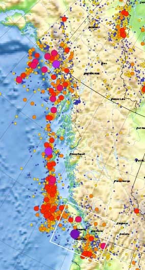
This detail of the Natural Resources Canada/ Earthquakes Canada shows the historical record of earthquakes along the northwest coast of British Columbia. The larger the circle, the greater the magnitude.
Most, not all, the earthquakes took place in the tetonic plate boundaries off the coast in the middle of the Pacfic Ocean, although the map does also show quakes on Haidi Gwaii. However, large quakes can be felt far inland. The magnitude 9.2 Good Friday earthquake in Alaska in 1964 did shake the town of Kitimat.


 This detail of the Natural Resources Canada/ Earthquakes Canada shows the historical record of earthquakes along the northwest coast of British Columbia. The larger the circle, the greater the magnitude.