Kitimat voices at Northern Gateway: Kitimat Valley Naturalists

Northwest Coast Energy News will use selected testimony from the Joint Review hearings, where that testimony can easily turned into a web post. Testimony referring to documents, diagrams or photographs will usually not be posted if  such references are required. Depending on workload, testimony may be posted sometime after it originally occurred. Posting will be on the sole editorial judgment of the editor.

By April MacLeod, Walter Thorne and Dennis Horwood

We would first like to thank the Haisla Nation

hosting this hearing. We recognize we are guests on Haisla land and that we are also on Haisla territory. We would also like to thank the JRP for this opportunity to make the oral presentation.
Who is the Kitimat Valley Naturalists? We are an independent Kitimat organization. We’re open to the entire community and we are an active member of B.C. nature. Our goal as a group is to pursue outdoor nature-oriented recreation.

As a group, we have 40 years of bird and mammal records and research papers. We have been involved as stream keepers, working closely with Department of Fisheries and Oceans. And we are also considered by the birding community to be citizen scientists.

We believe we have little to gain and much to lose from an oil pipeline, terminus and tanker traffic, and the purpose of this presentation is to show what we believe we have to — we stand to lose.

The focus of this whole presentation is the Kitimat River estuary and it is one of the five largest estuaries on our northern B.C. Coast. It is ranked by Ducks Unlimited as one of B.C.’s most important estuaries. And to back that up, a technical report showed it was the top three in total biological and social values.

And so everyone is clear, scientists define an estuary as much more than just mudflats and meadows. The Kitimat River estuary in fact extends many kilometres past the inner tidal areas and well into Douglas Channel.

The estuary foreshore is a relatively flat area, and at a distance, its beauty and importance are difficult to see. Up close, however, things change.

The Kitimat River estuary is 1,230 hectares, and in perspective, that’s three times larger than Vancouver’s Stanley Park. It is covered in sitka spruce, western hemlock and deciduous trees, interspersed with lush meadows, slews, ponds and rivulets.

Rich, organic soils, packed with nutrients, help create immense fertile meadows. These meadows and land support the growth of many native species.

In the spring and summer, it is a wildlife — wildflower and wildlife heaven. In early times, the root of the chocolate lily, seen in the insert, was used by the Haisla and early pioneers as a food source.

Shooting stars are just one of the many wildflowers found in the meadows of the estuary. Many people, like me, a local native, native natural photographer, I like to walk around the estuary purely for the floral opportunity of — floral photographic opportunities.

The same nutrients that allow flowers to flourish also support a major outdoor activity, fishing.

Fishers from B.C., Alberta and the world come here to fish. Why? Because Kitimat is really a fishing Mecca.

Kitimat’s river — the Kitimat River brood stock is amongst the best in the world. Where else on this planet can you catch a 27-pound steelhead or a 76-pound Chinook salmon. Elite fly-in fishing lodges located throughout the Douglas Channel target Kitimat River fish.

The B.C. sports fishing industry yields annual returns in the billions of dollars. Kitimat’s share in a year is in the millions.

Kitimat is a 10 out of 10 fishing destination. And if you don’t like our fish, try our prawns. Even celebrities know about this area and come here to fish. When the Vancouver Canucks arrive, they keep it very secret.

The Kitimat and Douglas Channel river systems have attracted recreational anglers for decades, starting in the 1950s, as you can see. Some have an extremely high profile: The Right Honourable Prime Minister John Diefenbaker, Kevin Costner, the actor, and Carey Price, a B.C. boy, our goalie for the Montreal Canadiens.

Hunters as well as fishers depend on the Kitimat River estuary. Birds, like fish, are attracted to estuaries. The Kitimat River estuary is a stopover during both the spring and fall migration. Trumpeter swans that nest in Alaska fly here and stay for the winter.

One of the major groups of migrants are waders, long-legged birds that generally feed in the shallow waters and mudflats. Over 20 species of this group of birds use our estuary as a fast-food outlet. They stop, stay for a day or two, then fly on to as far away as South America.
Twenty years ago, great blue herons were a rare bird at any time of the year in the Kitimat Valley. This blue-listed bird, meaning an indigenous species considered vulnerable, has made the Kitimat River estuary its winter refuge. Now these birds are regularly reported on Christmas bird counts.

Snow geese used to be a rare bird here as well. We now record them regularly during spring and fall migrations and in flocks sometimes exceeding 500 individuals. This estuary has become a vital link along their migration route.

Typically, many birds desert the estuary during the summer months, but we still have many species that rely on the estuary trees, meadows and waterways to raise their young.
One of the most mysterious birds in the world lives here. The marbled murrelet, a robin-sized seabird thrives in the Douglas Channel system. These birds feed by day in the rich channel waters, but at nightfall they fly inland to old-growth trees and locate their saucer-sized nest in complete darkness. No scientist, or anyone for that matter, knows how they do this.

The estuary and Douglas Channel have immense recreational values. Sailboats, kayaks and power craft all ply the local waterways. Alaska-bound yachts often divert into Douglas Channel. Why do they come here? They come here for solitude, pristine wilderness, private beaches that urbanites from all over Canada can only dream about.

Author John Kimantas predicts Douglas Channel will evolve into a world- class kayaking destination. He is considered to be the Pacific Coast authority on kayaking.

We are blessed with a network of Haisla cabins that all visitors are welcome to use. These two kayakers visit here every year from Alberta. They keep coming back. Why? They want that wilderness experience.

Within the shelter of Minette Bay, a major part of the estuary, local recreational events such as dragon boat racing and training take place. We have several non-commercial hot springs. Anyone can use them at any time of the year. They’re free.

Ecotourism on the estuary and throughout the Douglas Channel system is second to none. It is simply world class. Where else on the same day can you see three different looking bears on the same day? Lots of places have black bears, but we have Kermode bears and grizzlies a plenty. They love our salmon and we enjoy watching them fish.

Orcas regularly visit here in spring but can be seen at any time. Sea lions come and go with the fish and tides. Seals are always present in the channel, estuary and even the river. They add character and enjoyment for visitors and locals alike.

But nothing — absolutely nothing — beats the sight of a sounding humpback whale. If we lose our whales, we know we will have lost much more.

So in conclusion, the Kitimat Valley Naturalists believe we need to strike harmony and balance in our ecosystem here and, as such, we believe the Northern Gateway is not an acceptable risk. We simply have too much to lose.


Enbridge confirms that Gitxsan hereditary chiefs formally reject pipeline deal

The Gitxsan hereditary chiefs have formally rejected the deal signed in December by Elmer Derrick to support the Enbridge Northern Gateway pipeline.

A meeting in Hagwilge Tuesday evening rejected by a vote of 28 to 8 the controversial equity deal.

The vote may also lead to the end of the blockade of the Gitxsan Treaty Society office in Hazelton.

Gitxsan spokesman John Olson told CFJW says there needs to be an all-clans meeting before the blockade is lifted.

“And I say it’s an all clans meeting, that means the Gitxsan Treaty Society members are more than welcome to come out and participate in this meeting, and I think that’s a step in the right direction,” Olson explained.

The chiefs say they want a written acknowledgement from the society that the Enbridge deal is rejected before removing their blockade, which went up shortly after Derrick announced the agreement in early December.

Enbridge Northern Gateway spokesman Paul Stanway issued a statement:

Enbridge has learned that the Gitxsan Hereditary Chiefs have reconsidered their prior endorsement of Gitxsan participation as equity partners in our project

While we are disappointed at this shift in stance in relation to our 2009 protocol agreement with the Nation and in relation to 2011 meetings with Hereditary representatives, we respect this decision.

We look forward to receiving written communication from the Gitxsan Hereditary chiefs, so that we have greater clarity in relation to their current perspectives. And we will continue to engage with the Gitxsan Nation in relation to the project.

In the meantime, we will also continue to work and engage with corridor First Nations groups, including the more than 20 groups who in recent weeks have fully executed and endorsed equity participation agreements deals with Enbridge.

Links January 17, 2012

Kitimat council votes to hold Northern Gateway poll sometime in the future

Phil Germuth
Kitimat District Councilor Phil Germuth. (Robin Rowland/Northwest Coast Energy News)

Kitimat District Council voted Monday night, Jan. 16, 2012, to hold some sort of poll or vote to find out whether the community supports the Enbridge Northern Gateway pipeline project.  The timeline of the project and how the poll would be conducted were unclear after the vote.

Rookie councillor Phil Germuth had filed a notice of motion proposing that the “District of Kitimat put out a survey to residents asking them for their opinion on the Enbridge project.”

A proposed survey Germuth circulated  had this a preamble that said:


As this project has generated much discussion  and public awareness I feel it would be beneficial to council  to know what the will of the people is.  If the public is anywhere 50-50 on this then council’s position to remain neutral  would be justified. However. if the public opinion  is in the range of 65-35, be it for or against the project, then council may consider changing our stance.

The previous council had voted to remain strictly neutral on the controversial project.

A sample survey contained six questions that would ask if people supported the pipeline, the super tanker port, whether or not Kitimat residents would support the project if they received royalties and what environmental precautions would be wanted if the pipeline project was approved. Two questions concerned natural resources policy, whether or not bitumen should be refined in Alberta and whether Canada should process its own natural resources.

How the poll would be conducted was unclear from Germuth’s proposal. His preferred choice was a double envelope mail ballot, similar to the one used in BC’s HST referendum. He noted that a professional survey carried out by a major polling firm would be too expensive and an internet survey would be unreliable.

After the motion was moved and seconded, Councillor Mario Feldhoff immediately proposed an amendment calling for the survey to be carried out after “after the completion of the JRP process.” Feldhoff argued that Kitimat residents should be able to decision once all the evidence had been presented to the panel reviewing the project.

At this point, Councillor Rob Goffinet began asking when exactly the Joint Review Process would be completed.

Did the councillors mean once all evidence was heard, after final arguments or as the JRP report was being presented to the federal cabinet.

Rob Goffinet
Councillor Rob Goffinet argues on the motion to hold a poll of Kitimat residents on the Northern Gateway pipeline. (Robin Rowland/Northwest Coast Energy News)

That question is key, since the Joint Review Panel changed the rules of procedure on January 4, 2012, a decision that has caused confusion every day of the hearings so far. The panel has split the hearing process in two, unlike the LNG hearings last June. Chair Sheila Leggett now calls testimony by intervenors “community hearings,” and is restricted to “personal experience.” Any questioning of witnesses is postponed until a round of final arguments.

Feldhoff’s amendment was adopted, but without any clarification of what the motion meant by “completion of the JRP Process.”   Council then voted for the motion to hold the poll.

There is more uncertainty now surrounding how the Joint Review Panel is proceeding, the rules have already changed once.  Prime Minister Stephen Harper is still threatening to stop certain groups, with US funding support, from participation in the review process, although how he could do that and leave the panel with any credibility and independence is also uncertain.

Any attempt by Harper and his government to block people or groups appearing before the JRP may result in a court challenge, which might delay the “completion” even further, contrary to the wishes of the government and the oil patch.

That means the date of any poll in Kitimat would also be uncertain.

Germuth argued repeatedly that is likely that the majority of people in Kitimat have already made up their minds.

Report on Enbridge Kalamazoo spill delayed until fall: Michigan media

The official United States National Transportation Safety Board report on the Enbridge pipeline breach and oil spill at Kalamazoo, Michigan has been delayed to the fall, according to local media reports.

The Kalamazoo Gazette and WDIV TV say the report will be six months late.

The Associated Press, quoting the Gazette says:

The National Transportation Safety Board attributed the delay to other investigations into separate pipeline incidents.

“Our investigations look at numerous aspects that could have played a role in the accident, such as maintenance, human factors, pipeline operations, and materials,” said NTSB spokesman Peter Knudson.

“We’ll also look at the emergency response and environmental remediation efforts to assess how they were handled.”

Local Enbridge spokesman Jason Manshum said the company will be able to finish its internal investigation after the report is released. Manshum said Enbridge is working to take what it’s learned from the spill and share that knowledge.

Costa Concordia followed course similar to Queen of the North

Costa Concordia course track
The track of the Costa Concordia before it ran aground, based on data from Lloyd's List and posted on the BBC News website.

Tracking data obtained by the definitive British shipping news service, Lloyd’s List (subscription required) and posted on both the Lloyd’s and the BBC News websites show that the cruise ship Costa Concordia was far off its assigned and programmed course before it ran aground near the island of Giglio.

The BBC reports:

Costa Cruises boss Pier Luigi Foschi accused Capt Francesco Schettino of sailing too close to a nearby island in order to show the ship to locals.

The captain blames the disaster on rocks which were not on his chart.


The data shows that the Costa Concordia, with 4200 passengers and crew on board veered close to the island of Giglio before hitting rocks just 150 metres from shore.  The closest any cruise ship has ever been authorized to come close to the island is 500 metres.

The course of the Costa Concordia, heading straight for an island, looks similar to the course taken by the Queen of the North when it hit Gill Island. The difference, of course, is that while the Queen of the North failed to make a course correction at Wright Sound, the Costa Concordia was apparently deliberately taken off course.

Bloomberg News reported:

The captain of a Carnival Corp. cruise liner ordered the ship off its programmed route, an “error” that caused it to hit rocks off Italy’s coast in an accident that killed at least six people, the chairman of the cruise ship’s operator said.

The Costa Concordia’s route was set electronically before it left Civitavecchia near Rome…and the ship shouldn’t have been so close to the Giglio island where it struck rocks, ripping a hole through its hull, Costa Crociere Chairman Pier Luigi Foschi said at a press conference in Genoa…

“We can’t deny that there was a human error,” he said. “The route had been properly programmed in Civitavecchia. The fact that the ship strayed from that course can only be due to a maneuver that was not approved, not authorized nor communicated to Costa Crociere by the captain of the ship.”

According to Reuters and other news reports, the danger is a devastating oil spill from the capsized ship. Italy risks environmental disaster if ship fuel leaks.

As the Costa Concordia shifted dangerously on Monday, Italy’s environment minister raised the prospect of an environmental disaster if the 2,300 tonnes of fuel on the half-submerged cruise ship leaks.

The ship’s fuel tanks were full, having just left the port of Civitavecchia, north of Rome, for a week-long Mediterranean cruise, when it ran aground on Friday…

The area where the ship capsized, off the island of Giglio, is a natural maritime park noted for its pristine waters, varied marine life and coral. It is known as an excellent diving site.

“The environmental risk for the island of Giglio is very, very high,” Environment Minister Corrado Clini told reporters. “The aim is to prevent the fuel leaking out of the ship. We are working to avoid this. It is urgent and time is running out.”

Related Links: Costa Concordia

AFP Ocean giants’ ban needed on Italy coasts: environmentalists
Toronto Sun Human blunders seen at heart of Italy ship disaster
AP via Globe and Mail Rescue operations resume in Italian cruise ship disaster

Related Links: RMS Titanic There are now so many comparisons to the sinking of the Titanic, almost a century ago, with the sinking of the Costa Concordia, that Google News has now created tracking link for those stories.

Twitter spam infects Kitimat Northern Gateway debate

The debate over the role of Kitimat in the Northern Gateway pipeline debate is being infected by ongoing Twitter spam.

Twitter spam
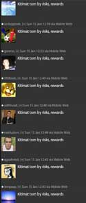
Examples of the Twitter spam infecting the Kitimat pipeline debate

Starting late Saturday and continuing Sunday, Twitter messages  frequently appear, with many different identities, but few if any followers and with one message  “Kitimat torn by risks, rewards.”

Twitter spam
Spam is infecting the Twitter debate on Kitimat and the Northern Gateway pipeline

The message refers to a headline in the Vancouver Sun,  by Gordon Hoekstra,  part of his coverage of the first day of Joint Review hearings on the pipeline,  Kitimat torn by risks, rewards, but the spam doesn’t include a link to the original Vancouver Sun story.

References to Kitimat are appearing more frequently as interest grows in the story of the Northern Gateway pipeline.   While many of the tweets are informed opinion on all sides of the debate with appropriate links, there are also a growing number of tweets by conservatives, mainly in Alberta and Saskatchewan, that clearly show complete ignorance of the issue.

Clarification One key example from this weekend.  There have been tweets from people both in Alberta and Saskatchewan claiming there are no forests in Kitimat. They look at a map and see the boundaries of the Great Bear Rainforest and decide that saying that Kitimat is surrounded by forest is a “green lie.”

Northwest Coast Energy News is asking for Twitter for a comment on the spam.

Editorial: BC and Canada must ask why the Costa Concordia sank

How could one of the most modern cruise ships in the world, the Italian liner Costa Concordia, presumably with GPS, satellite navigation, modern charts both on paper and computers, triple redundant aircraft type “bridge navigation systems,” depth sounders and hopefully look outs, hit rocks near the island of Giglio off Italy in calm seas on a calm night in the Mediterranean?

Update: Ship’s owners blame human error
Northwest Coast Energy News Cruise line issues statement emphasizing safety precautions, but blaming captain

Media reports are saying the sinking of the Costa Concordia was caused by “human error.”AP via The Globe and Mail Cruise captain’s conduct blasted as divers find more bodies

Maritime authorities, passengers and mounting evidence pointed Sunday toward the captain of a cruise liner that ran aground and capsized off the Tuscan coast, amid accusations that he abandoned ship before everyone was safely evacuated and was showing off when he steered the vessel far too close to shore.

BBC Cruise captain ‘committed errors’, say ship’s owners

The company operating a cruise ship that capsized after hitting rocks off western Italy on Friday says the captain may have “committed errors”.

He appears to have sailed too close to land and not to have followed the company’s emergency procedures, Costa Crociere said in a statement.

Capt Francesco Schettino is suspected of manslaughter, but denies wrongdoing.

Daily Telegraph Cruise disaster: ship’s owners blame human error

Independent on Sunday Jan 15, 2012
Front page of the UK's Indpendent on Sunday Jan. 15, 2012

(Media reports are different. Some say rock, since there is clearly a huge rock lodged in the ship’s upturned hull seen in news photos and media video, or a reef or a sandbar)

It’s a question being asked around the world at the moment, as the rescue operation continues at this writing. It’s a question being asked up and down the coast of British Columbia, not only because similar cruise ships ply the Inside Passage but because of the debate over the possibility of bitumen-carrying supertankers on the coast.

There’s another question you’re already hearing on when the television networks interview experienced mariners and naval architects. The Mediterranean off the west coast of Italy isn’t exactly uncharted waters, that region has been sailed for “thousands of years.”

The headline in Sunday’s UK Independent, “We hit a rock, it shouldn’t have been there,” brings to mind Odysseus. When Odysseus left the bed of Circe, the seer, one of the things she warned him to beware of were the “wandering rocks.” Most scholars believe that the wandering rocks were far to the south of the accident scene. The British sailor Ernle Bradford, who sailed what he thought to be the route of Odysseus in the early 1960s, and published his story in Ulysses Found, believed the Wandering Rocks were in the Straits of Messina, and might have referred to eruptions from the volcano Stromboli.

The cause of the accident is under investigation by the Italian police, who are holding the ship’s captain, Francesco Schettino, for questioning. The sinking will also be investigated by Italian and presumably other maritime authorities (since there were many nationalities, including Canadians, on board).

It is highly unlikely that there were “wandering rocks” in the path of the Costa Concordia. That’s not the point, the point is that Odyssey reflects the fact the mariners from Mycenean Greece and even earlier the Minoans and Phoenicians were sailing the waters where the Costa Concordia grounded by at least 1250 BCE, the usually accepted date of the Trojan War. Local mariners and fishers probably sailed that area for a couple of thousand years before the first traders ventured into the Mediterranean. If we take 1250 BCE as a starting date for trading ships in that region, that is 3,262 years ago.

The island of Sardinia, not far from the sinking site was, according to scholars, (including the distinguished Robin Lane Fox in Travelling Heroes Greeks and Their Myths in the Epic Age of Homer), the cross roads of the Mediterranean from about 1100 BCE to about 700 BCE. That’s because with the limited capacity of the shore hugging galleys and freighters of the era, Sardinia was a perfect meeting and trading point for the Celts to the north, the Iberians to the West, the Etruscans and others in Italy, the Carthaginians and west African people to the south and the great traders of that age, the Greeks and the Phoenicians from the east.

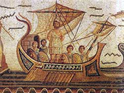
odyssseusmosaic
Odysseus as portrayed on a Roman mosaic.

Simple conclusion, if we take the date from 1100 BCE, the sea around Giglio has been charted for 3,112 years. Those scholars of the sea believe that the warnings Circe gave Odysseus were adapted by Homer from real sailing instructions probably passed down as oral poems in age, between the collapse of Mycenean culture and the rise of classical Greece, when only a tiny handful of Phoenicians could read or write.

One has to wonder if the bridge crew of the Costa Concordia had just had a Roman chart, whether or not the cruise ship could have avoided the rocks/sandbar/reef.

So what went wrong and what does that mean for the controversial plan to have hundreds of both bitumen and LNG laden tankers going up and down the British Columbia coast?

Britain’s Daily Telegraph is already asking what went wrong, in Cruise disaster: Perfect storm of events caused Costa Concordia crash. The Telegraph is pointing out something critical to the plans by Enbridge for a highly computerized navigation system for Douglas Channel, the Inside Passage and the British Columbia coast: that many of today’s bridge officers don’t have the skills that Capt. George Vancouver would have demanded even from the youngest teenaged  midshipman when he first charted the  west coast for the Royal Navy.

The captain was reported to have said he hit a rock that was not marked on his charts. But that failed to explain adequately the scale of the disaster, which experts said should be unthinkable….

The Concordia, whose officers were all Italian, will also have operated Bridge Team Management, a system adopted from the aviation industry whereby each operation is double and triple-checked by several members of the crew….

Modern ships are required to carry voyage data recorders which store detailed information about the vessel’s speed, position, heading, radar and communications…

The first thing investigators will have to determine is whether the vessel should even have been where it was.

A source close to the investigation told a leading Italian newspaper that the boat was on the wrong course — possibly due to human error — and was sailing too close to Giglio.

The ship should have passed to the west of the island, rather than the east, according to this theory.

Yesterday fishermen on Giglio and in Porto Santo Stefano said it was very unusual for such a large ship to attempt a passage to the east of the island….

Douglas Ward, a cruise ship expert and author of Berlitz Ocean Cruising and Cruise Ships, said: “Crew don’t have as much training as in the past.

“Ships today are built with completely enclosed navigation bridges and the navigators don’t even have to learn how to use a sextant, whereas marine officers in the past always had to.

“The advance in hi-tech navigation systems is so good that we have come to rely on them. But even these can fail — look at car satnavs.”

So if the Enbridge Northern Gateway project is approved, and even if Enbridge implements all the navigation improvements it says it will, it all comes down to the competence of a bridge crew. Perhaps a GPS could tell them to turn to port instead of starboard (as GPS units in cars sometimes do) and there could be tanker hitting Gill Island, just where the Queen of the North sank, even if it is tied to an escort tug.

What makes the sinking of the Costa Concordia  even more frightening is the negligence of Stephen Harper  and his cabinet cronies who are gutting Canadian Coast Guard and DFO resources on both the West and East Coasts.  It will be years before those super tankers might start coming up Douglas Channel.  There was lots of rescue capability on the coast of Italy from the Italian coast guard and local boats. What about the giant cruise ships, a key aspect of the British Columbia economy?  What if one of those ships got in trouble? The captain of the Costa Concordia was able to beach the ship right by the sea wall at the port of Giglio.  On the rocky coast of BC,   that giant cruise ship could go to the bottom in minutes just as the Queen of the North did, with little or no immediate hope of rescue.


Bradford's voyage
A detail of a map from Ernle Bradford's Ulysses Found, published in 1964, retracing the voyage of Odysseus. Homer's epic is probably a record of a voyage around 1250 BCE. The point where the Costa Concordia sank has been added.

Links January 12, 2012

Haisla speak to Joint Review of traditional knowledge, fears of a polluted future

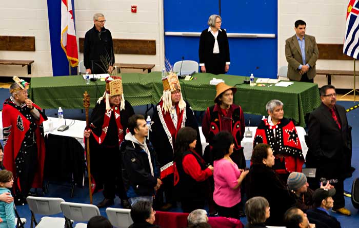
Haisla chiefs appear before the Joint Review Panel
Members of the Northern Gateway Joint Review Panel, chiefs of the Haisla Nation and spectators watch the welcoming ceremony before the start of hearings at Kitamaat Village, Jan. 10, 2012. (Robin Rowland/Northwest Coast Energy News)

Chiefs of the Haisla Nation were the first witnesses to appear before the Northern Gateway Joint Review panel  when the “community hearings” began in Kitamaat Village on Jan. 10, 2012.

The seven,  Chief Counsellor Ellis Ross, Jassee chief Samuel Robinson, chiefs Rod Bolton, Ken Hall, Clifford Smith, Marilyn Furlan and Henry Amos spoke eloquently of Haisla traditional knowledge of the region, problems in the past with environmental degradation from local industry and their fears for a future if Northern Gateway pipeline proposed by Enbridge Inc. is approved.

After a welcome ceremony by the Spirit of Kitlope drummers and dancers, the first witness was Samuel Robinson, the Jassee chief of the Haisla Nation and a world renowned carver in wood, silver and gold.  Robinson was the first of many First Nations leaders, first the Haisla at the Kitamaat Village hearings and later on Jan. 12 in Terrace the Kitsumkalum to speak of the collapse of the oolichan fishery.

“We have always been taught to take only what we need and to leave the harvest site in the same or better manner, condition, which — when we leave the area. This is a global concern to keep everything clean now,” Robinson said.

Henry Amos voiced his distrust for the government and the Joint Review process. “This is my own personal opinion that we are, the Haisla are already at a disadvantage…. I also know that you’re an independent body, which is good in a way, but what bothers me the most is that you’re appointed, I think from your information it was from the Minister of Environment and the National Energy Board. You’re appointed by the Federal Government and it’s the same government that is telling the world that this project should go ahead. That is my biggest concern right now, is that we are in a disadvantage.”

Chief Counsellor Ellis Ross spoke about the problems with cleaning up a relatively minor diesel spill in Kitimat harbour, “I was working for a charter boat company out of Kitimat, District of Kitimat. And a tugboat down at our dock here sunk, dumping all its diesel into the water…

“Optimal conditions; the water’s calm, you’re working off the dock, you got every gear that you can think of, you can pack it down. We still couldn’t pick that diesel up. In fact, most of it got under the dock and it took a year for it to all leech out, but we spent a couple days down there trying to do what we could, basically mopping it up.

“When we were done with the absorbent pads and booms, the first thing we found out is that, actually, nobody wanted to deal with that product. Our company had an agreement with the pulp and paper mill to burn the product in their furnace, natural gas furnace, so the higher-ups agreed to it, but when we got to the door, their workers refused us. So we were stuck outside the pulp and paper mill with these bags and bags of booms and absorbent pads.

“So they came down with a condition. You guys can burn it in our furnace, but you guys have got to pack it up there yourselves.

“So covered in diesel, soaking wet, stink, and nobody wanted to come near us, we had to do it ourselves. Nobody would touch that.”

Read the Haisla testimony in their own words. Here are links to the unfiltered voices of the chiefs from the transcripts of their testimony:

NOTE: The Haisla First Nation is asking for corrections to the transcripts.  When those corrections are received, the pages will be updated.