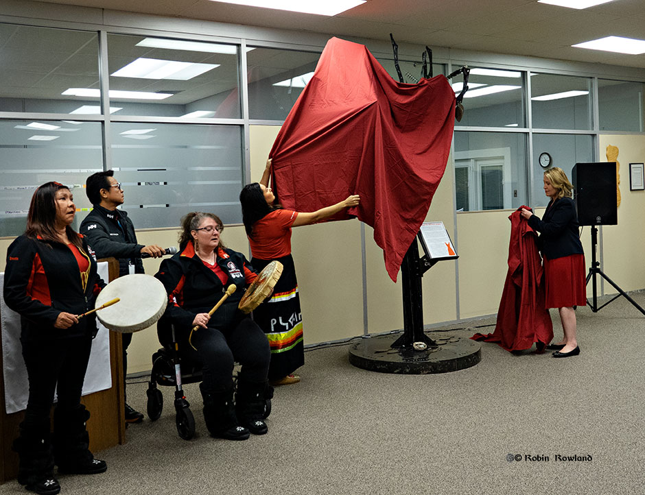
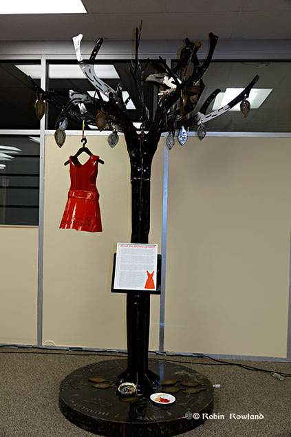
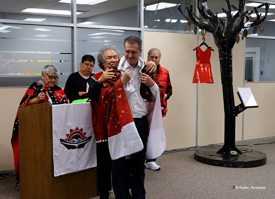
A welded and sculpted metal tree created by two Grade 12 students in memory of Canada’s murdered and missing indigenous women and girls was unveiled in the lobby of the Kitimat Valley Institute on Friday, October 4, 2109, where it will be on permanent display.
The tree was created by Trinity Harry, 17, Ojibwa Nation, from Little Black River, Manitoba and Joseph Ginter, 16, Ojie-Cree, from Garden Hill, Manitoba, students at the Russell Vocational High School in Winnipeg. The project was supported by the Arx & Sparx Welding Camp Program and the CWBwelding Foundation with sponsorship from LNG Canada. The company is supporting welding camps for young people to introduce them to a career in the skilled trades.
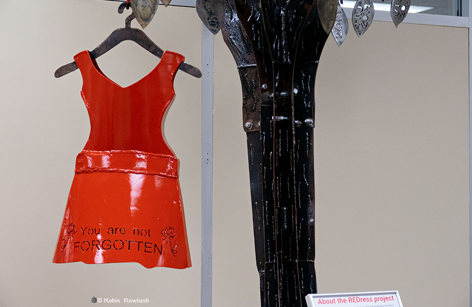
The memorial tree features a red dress, part of the Red Dress Project created by artist Jamie Black to bring attention to the issue of missing and murdered indigenous women across Canada by displaying red dress related art work across Canada. Most of the women, speakers and guests at the unveiling wore a red dress at the ceremony.
Harry and Ginter, along with their instructors, spent over 300 hours designing and fabricating the tree.
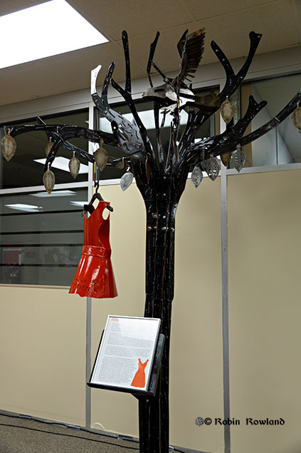
The memorial tree. (Robin Rowland)
A plaque describes the tree as “dying.” Fallen leaves on the base represent the fallen indigenous women and girls. Future welding classes will add more leaves to honour more women.
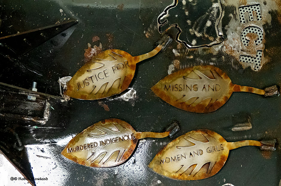
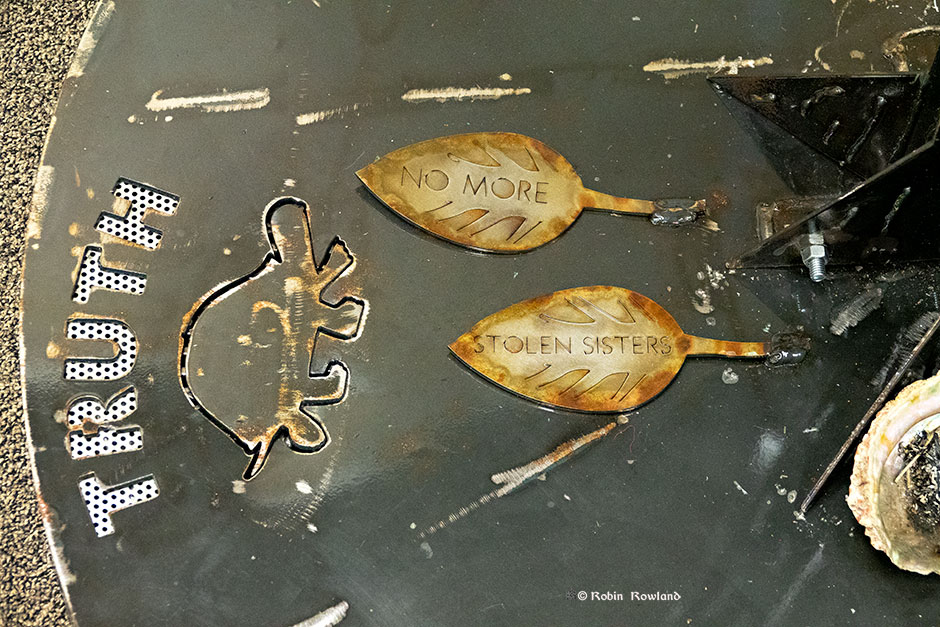
The fallen leaves call for justice.( Robin Rowland)The leaves symbolize the indigenous women lost on Turtle Island (Robin Rowland)An eagle sits high in one of the branches of the tree (Robin Rowland)
The eagle represents the love for the missing.
A salmon in the eagle’s talons. (Robin Rowland)
The salmon represents the Haisla Nation on whose traditional territory the sculpture is displayed.
The red of the dress has important spiritual value for many indigenous people in North America. (Robin Rowland)
According to the RCMP, at least 1200 indigenous women have been murdered or have gone missing during the past 30 years. The plaque says the red dress was chosen because “So red is really a calling back of the spirits of these women and allowing them a chance to be among us or have their voices heard through their family members and community.”
The memorial tree. (Robin Rowland)
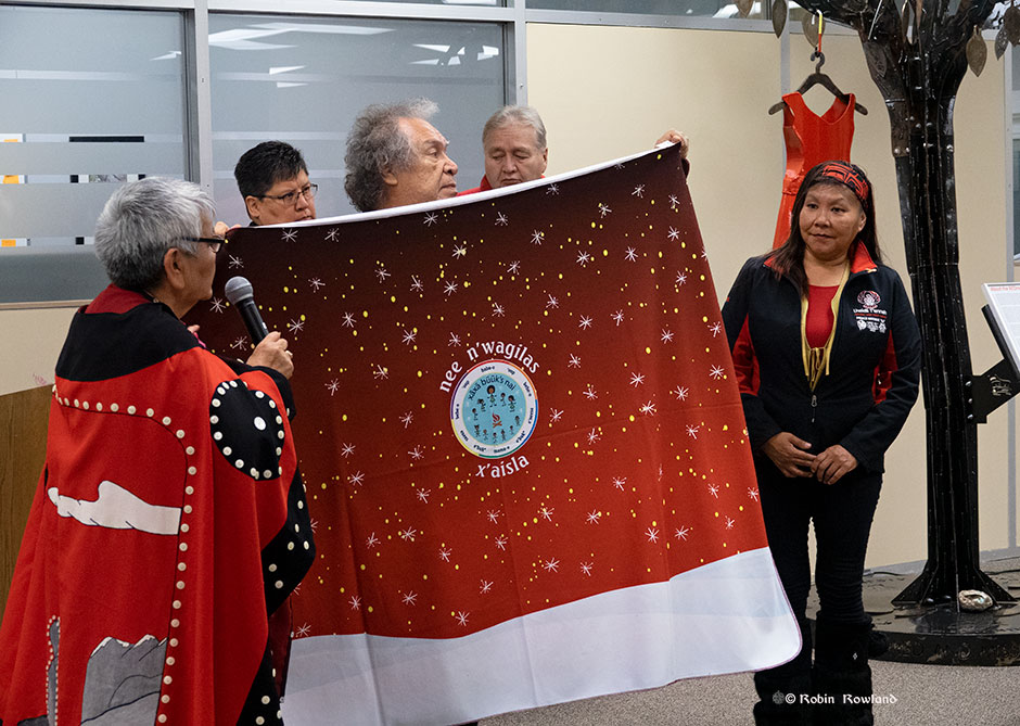
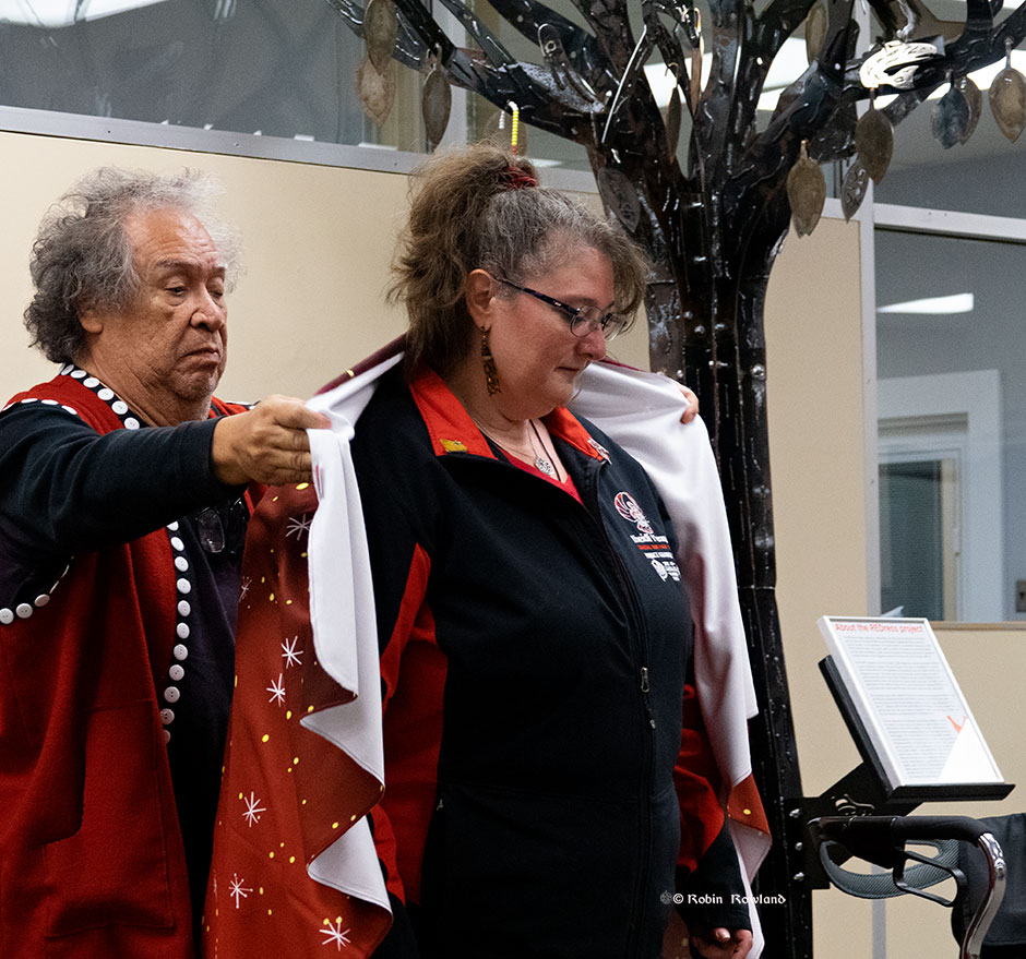
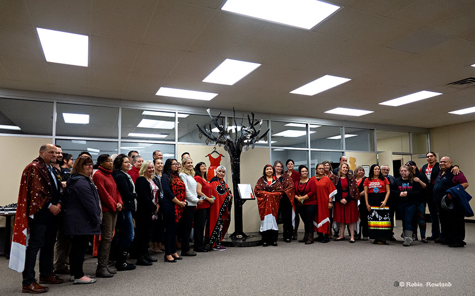
Haisla Nation chief counsellor Crystal Smith speaks to the gathering (Robin Rowland)LNG Canada CEO Peter Zebedee speaks to the gathering. Listening is Haisla Elder Marilyn Furlan. (Robin Rowland)Brenda Wilson of the Gitxsan Nation gave a moving address. Brenda’ sister Ramona was murdered near Smithers in 1995. (Robin Rowland)Haisla Elder Nelson Grant presents Brenda Wilson with a blanket in recognition of her work in leading an awareness march along the Highway of Tears. (Robin Rowland)Haisla Elder Nelson Grant presents Ann Bozoki of the Lheidi T’enneh Nation and the Khast’an drummers with a blanket in recognition of her work in raising awareness of missing and murdered indigenous women. (Robin Rowland)Haisla Elder Nelson Grant presents LNG Canada CEO Peter Zebedee with a blanket to thank him for the company support of the project the led to the memorial tree.(Robin Rowland)As can be seen in this group shot most of the women present wore red dresses for the unveiling ceremony. (Robin Rowland)
In 1999, a tropical fungus called by scientists Cryptococcus gattii unexpectedly appeared on Vancouver Island. Spores from the fungus can cause a sometimes fatal pneumonia-like illness in humans, cats, dogs and marine mammals, including porpoises and dolphins. There is one reported case of the fungus infecting a great blue heron.
Normally, the fungus is most common in Papua New Guinea, Australia and South America. Today it is also found growing in the coastal forests and shoreline areas of southern coastal British Columbia, Washington and Oregon.
A study, released today, supported by the US Centres for Disease Control and Prevention (CDC) is described as tracking multiple pieces of a puzzle. It suggests that a singular event, like a natural disaster, could have been the missing piece that brought the whole picture together.
The scientists, microbiologist Arturo Casadevall, MD, PhD, Chair of Molecular Microbiology and Immunology at the Bloomberg School at Johns Hopkins University, and epidemiologist David Engelthaler, PhD, of the Translational Genomics Research Institute, Flagstaff, Arizona, suggest that a series of events brought the fungus to BC culminating in its possible spread by the tsunami unleashed by the 1964 magnitude 9.2 earthquake in Anchorage, Alaska. The scientists wrote that the tsunami idea seemed to fit the “when, where, and why” of this disease emergence.
The US CDC has tracked more than 300 C. gattii fungal infections in the Canadian and U.S. Pacific Northwest region since the first case on Vancouver Island in 1999. Prior to that time, infections with this fungus had been confined almost entirely to Papua New Guinea, Australia, and South America. The fungus typically infects people through inhalation. It can cause a pneumonia-like illness, and may also spread to the brain, causing a potentially fatal meningoencephalitis. Although the disease is fairly rare and few infected people become ill, for those who become infected, published case reports suggest an overall mortality rate of more than 10 percent.
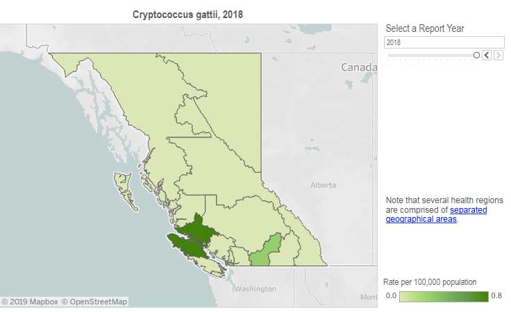
Incidence of Cryptococcus gattii infection in BC (BCCDC)
The British Columbia Centre for Disease Control (BCCDC) says Vancouver Island has one of the highest rates of infection in the world. Each year in B.C. from 10 to 25 people become sick from cryptococcosis and about 16 per cent die from the disease.
In the Northern Health region, however, only one case, in 2017, has been reported since 2009 and that was in the Northern Interior region.
The BCDC says the fungal infection can take several months to incubate after exposure. Only a few people exposed to the spores will become ill. Cryptococcus gattii is a reportable disease in British Columbia.
The new study is suggesting that the fungus first traveled in ships’ ballast tanks. After the Panama Canal opened in 1914, shipping increased significantly between Atlantic and Pacific ports.
The scientists believe that in South America, the fungus began washing from local rivers into shore waters. Then ships loaded ballast water, which research has shown is a common mode of transport for invasive species. The ballast water then spread the fungus to North American waters. Ships in those days routinely took on such ballast water in one port and simply discharged it, without treatment, in another.
How the tropical pathogen established itself in such a cool northern area was originally unclear. Theories have included global warming and the import of tropical eucalyptus trees.
The new study proposes that once in the North Pacific the fungus went unnoticed until the 1964 earthquake brought the fungus widely ashore and into coastal forest area.
It then took several decades for the fungus to evolve in its new habitat so that it could survive and then thrive first in coastal Vancouver Island, then across the island to the Lower Mainland and down to Washington and Oregon.
Casadevall says, “The big new idea here is that tsunamis may be a significant mechanism by which pathogens spread from oceans and estuarial rivers onto land and then eventually to wildlife and humans, If this hypothesis is correct, then we may eventually see similar outbreaks of C. gattii, or similar fungi, in areas inundated by the 2004 Indonesian tsunami and 2011 Japanese tsunami.”
The Alaskan Earthquake was felt as far as 4,500 kilometres away. Effects were recorded on the Hawaiian Islands. The waves reported in nearby Shoup Bay, Alaska were 67 metres causing significant shoreline devastation. At Seward, Alaska, the tsunami wave was 9.2 metres. At Port Alberni it was 6.4 metres. North of Kitimat, at Ketchikan, the wave was just 0.6 metres and at Prince Rupert, 1.4 metres. There are no figures for Kitimat, but with no damage reported, it is likely that the wave was somewhere around a metre.
The tsunami continued south, affecting much of the coastline of western North America, even causing several deaths on the beaches of northern California.
Several hours after the earthquake, multiple waves flowed up Alberni Inlet, cresting at eight metres and striking the Port Alberni region, washing away 55 homes and damaging nearly 400 others
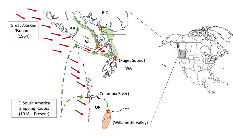
The study retrieved multiple fungus samples from the forests in the Port Alberni region. Studies show there are multiple infected sea mammals in the port’s waterways. Human and terrestrial and marine animal cases have also been reported along the western coast of Vancouver Island. The results suggest that the contamination of the Port Alberni region may be from the 1964 tsunami rather than from terrestrial dispersal from the eastern side of Vancouver Island.
Map showing where the 1964 tsunami could have deposited the fungus (Ecological and Evolutionary Science)
The early environmental analyses in British Columbia identified that the fungus was found in soils and trees in the coastal Douglas fir forests and in coastal Western Hemlock forests bordering the coastal Douglas fir forest. While these studies were “limited in geographical space” the contaminated landscapes were also the known locations of human and animal infections. Further ecological analyses have identified higher levels of soil and tree contamination at low-lying elevations close to sea level.
The researchers now hope to continue testing their hypothesis with detailed analyses of C. gattii in soils within and outside tsunami-inundated areas of the Pacific Northwest. They then want to compare the British Columbia fungus with DNA collected from other parts of the world.–to see if the same C. gattii subtypes found in Brazil and the Pacific Northwest are more widely present in seawaters around ports.
The paper: “On the emergence of Cryptococcus gattii in the Pacific Northwest: ballast tanks, tsunamis and black swans” by David Engelthaler and Arturo Casadevall is in the journal Ecological and Evolutionary Science
BCDC defintion Cryptococcus is a tiny (microscopic) yeast-like fungus. A species of this fungus, called Cryptococcus gattii, has been living on trees and in the soil on the east coast of Vancouver Island since at least 1999. More recently it has also been found in the Vancouver Coastal and Fraser Health regions. Infrequently, people and animals (e.g. cats, dogs, llamas, porpoises) exposed to this fungus become sick with cryptococcal disease (or cryptococcosis). Cryptococcosis can affect the lungs (pneumonia) and nervous system (meningitis) in humans. It affects people with healthy and weakened immune system. In rare cases, this disease can be fatal.
Many people will be exposed to the fungus sometime during their lives and most of these will not get sick. In people who become ill, symptoms appear many months after exposure.
Symptoms of cryptococcal disease include:
Prolonged cough (lasting weeks or months)
Shortness of breath
Headache
Vomiting
Fever
Weight loss
If symptoms occur, the disease can cause pneumonia, meningitis, nodules in the lungs or brain, or skin infection.
People are advised to see their doctor if they live in or visit an area where the fungus can be found and experience these symptoms.
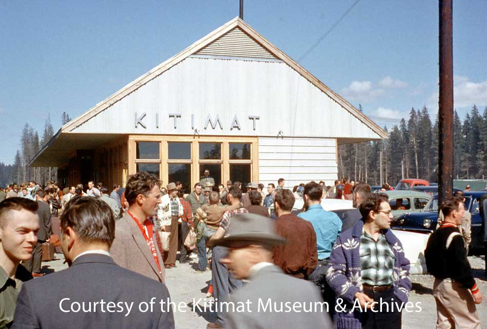
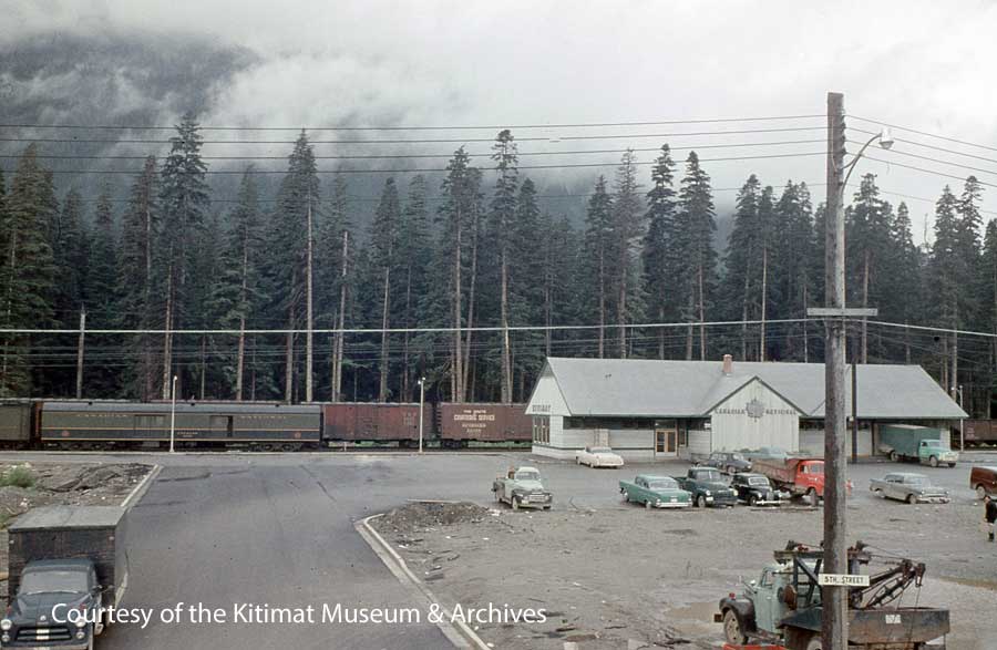
A crowd gathers at the Kitimat CN Station sometime in 1955. This picture may be of the station opening since the windows and trim are unpainted. (Walter Turkenburg/Kitimat Museum & Archives. ) See Note 1.
UPDATE: There will be a public meeting to discuss the future of the station in Kitimat on Thursday, April 11, 2019 at Riverlodge, in the Activity Room, at 7:30 pm.
March 12: This story has been updated to clarify that Kitimat Heritage has not yet discussed municipal, provincial or federal heritage status with CN. Also more information about CN telegraph communications has been added.
Kitimat Heritage and supporters in the community are campaigning to save the town’s old Canadian National Railway Station. Kitimat Heritage wants to preserve the station because it is symbolic of the earliest days of the townsite when Kitimat was first being built and celebrated as the 1950s “town of the future.”
District of Kitimat Council voted Monday February 25 to send a letter of support to CN and to take other appropriate measures to support an effort to save the old CN Railway Station in the Service Centre.
Retiring Member of Parliament Nathan Cullen (NDP Bulkley Valley) is also working at the federal level to get help to preserve the station. The provincial MLA Ellis Ross (Liberal Skeena) has promised he will work at the provincial level.
Louise Avery and Walter Thorne make a presentation to District of Kitimat Council on the future of the CN Station on February 25, 2019. (Robin Rowland)
Local historian Walter Thorne and Executive Director of the Kitimat Museum & Archives Louise Avery presented a package to council that gave the history of the station and the current state of negotiations with CN. (Disclosure I am chair of the museum board but not directly involved in the campaign. The opinions in this article are strictly my own and may not reflect the views of Kitimat Heritage or the museum)
There have been two architectural assessments of the railway station. The first by John Goritsas on behalf of the Kitimat Museum & Archives in 1992 and this year on behalf of Kitimat Heritage by Prince Rupert architect Alora Griffin.
While the station overall is in “desperate condition” it appears from both assessments that the core of the station is, as far as can be determined, structurally sound.
A close view of the station in 2014, showing the “desperate condition.” (Robin Rowland)
The station, built in 1955, has been in poor repair for years. According to Kitimat Heritage CN has said it sees no other clear alternative than to demolish the station given its run-down nature, the potential liability issues, and the revenue potential of the land.
If CN did want to demolish the station , it can’t at the moment because it is protected by both municipal and provincial heritage status. So far the question of heritage status has not yet come up in the discussions.
District of Kitimat Council first passed a bylaw giving the station heritage status in September 1985.The municipal heritage status of the station is part of the official Kitimat Community Plan, adopted by council in 2008.
The railway stations in Prince Rupert and Smithers are designated under the federal Heritage Railway Stations Act.
Only designated heritage railway stations that are still owned by a railway company under federal jurisdiction are subject to the nationwide Heritage Railway Stations Protection Act. Under the act no railway company may in any way alter, demolish, or transfer ownership of a designated heritage railway station without the authorization of the federal cabinet.
In the case of Kitimat, the Heritage Group has not yet officially asked CN to support designation.
CN officials, speaking to the heritage volunteers, have told them that the station is an “eyesore” and there is “revenue potential” from the station site as Kitimat gears up for the building of the LNG Canada plant and other projects including a proposed propane terminal.
The CN Station in 2012. (Robin Rowland)
Railway stations as brands
To understand what makes the Kitimat station unique, you have to know about the history of railway station construction in North America.
From the mid-nineteenth century until the First World War, a time when railways were the prime form of transportation, railway stations were designed to both attract paying passengers and to promote the railway brand. The railways hired the leading architects of the day to design metropolitan stations in grand style, often neo Classical like Toronto’s Union Station or Grand Central in New York or “Romanesque” such as Union Station in Nashville, Tennessee (now a Marriot Hotel) that resembles the style of Canada’s Parliament Buildings.
Montreal’s Windsor Station, once the headquarters for Canadian Pacific was also built in a Romanesque style.
The same care in architectural design and construction was applied to even the smallest railway stations in those early years—although many were based on same designs from stop to stop.
When the Grand Trunk Pacific was building the line to Prince Rupert a century ago the GT built iconic smaller stations (designated by the Plan Number 100-152) along the route, with fourteen in the Smithers subdivision, including at Tyee, Kitwanga and Kwinitsa. (See Vanishing BC Grand Trunk Pacific Stations)
The latter station is now part of the Kwinitsa Station Railway Museum & Park in Prince Rupert.
The Prince Rupert station built in 1921 is an example of a utilitarian brick box that has federal protection.
The designation says the Prince Rupert Station is an example is “significant as a very early example of a public building in the Modern Classical style. Executed in brick and trimmed with Tyndall limestone, the station design combines traditional composition with simple, stripped-down classical detailing.”
The Smithers Station is considered more special it is an important and rare example of the custom-designed “special stations” built by the Grand Trunk Pacific Railway (GTP) at several divisional points along its transcontinental line. This small group of specially designed stations represented a departure from the GTP’s overall policy of rigid standardization in depot design. (like the ones at Tyee, Kwinitsa and Kitwanga)
End of an Era
That era of great railway stations ended in 1929 with the Great Depression when commerce largely collapsed. Railways in North America had little money to spend on grand passenger stations. Then came the Second World War when the priority for the railways was supporting the war effort.
Railway historians say that after 1945 most spending for North American railways was to replace aging steam locomotives with new diesel locomotives. The railways also had to retire old rolling stock such as boxcars that had been kept in service during the war.
That meant even in the post war decade from 1945 to 1955 constructing new stations was not a priority. Those stations that were built, mostly in the United States, replaced buildings that were no longer usable. Most were “modern” brick boxes based on a utilitarian design that reached back to the 1920s or the newer “brutalist” buildings of mostly poured concrete.
Kitimat was a different case—there was a brand new branch line from Terrace. That meant Kitimat needed a railway station.
The architects who assessed the Kitimat station say it is an example of the modernist “form follows function” style of architecture popularized by Frank Lloyd Wright. The load bearing 2 x 6 trusses align the exterior walls which was one of Wright’s innovative ideas.
The station was designed by CN staff. The 1992 architect, John Goritos, said, “it was designed to suit the site and wasn’t a replica of any of other CN railway stations.”
The architects say that one reason the Kitimat Station was built of wood was not only that it had to be constructed quickly but the light weight was suited to the site which was on the Kitimat River flood plain filled in with sandy landfill.
Building the Kitimat branch line
As Alcan was planning and building Kitimat, the company signed transportation contracts with CN. That was the reason the branch line was built to the townsite, then past the sandhill to the aluminum smelter.
CN worked to build the new branch line for 38.5 miles crossing “difficult terrain of the area, including swamps, hard clay, rocks and watersheds.’ The route included three steel Pratt triangular truss bridges over the Lakelse, Wedeene, Little Wedeene Rivers and plus a number of smaller old fashioned traditional wooden trestles over creeks.
Canadian Transportation magazine reported in July 1952 that the branch line alone would cost $10 million 1952 dollars or $217,391.30 per mile.
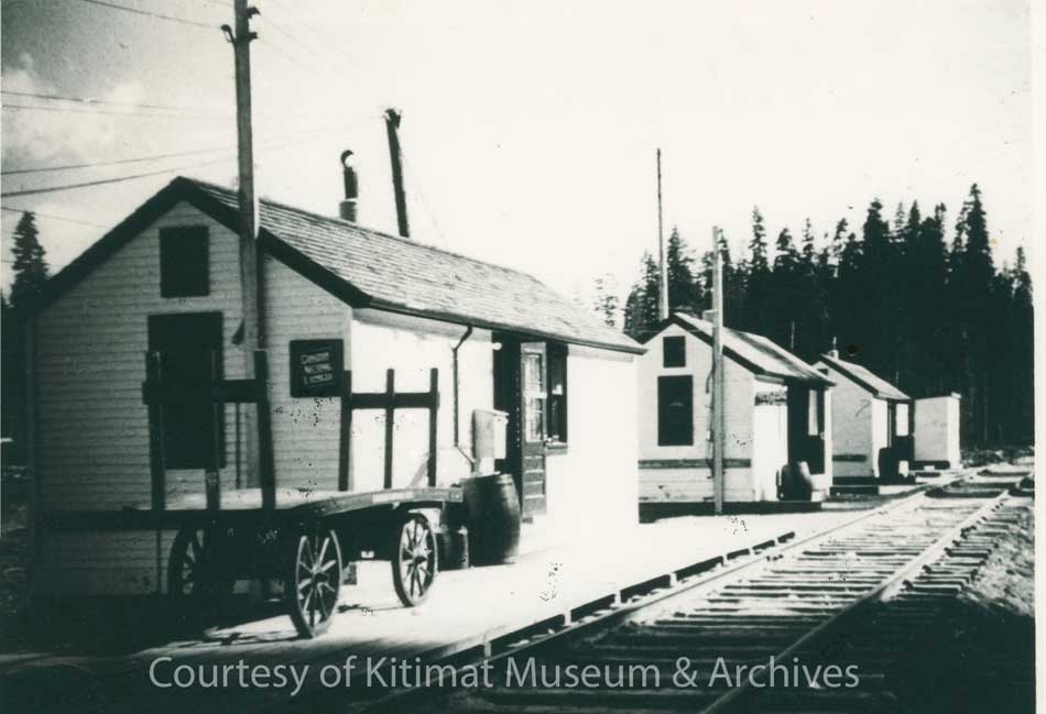
Freight travel began as soon as the branch line was completed in December 1954. Temporary huts acted as the train station when passenger service began in January 1955 but were soon overwhelmed.
It was CN practice to use huts (and sometimes a retired boxcar) to act as a temporary station until a new one was built. (Mrs. L Byron collection/Kitimat Museum & Archives)
Former Kitimat mayor Joanne Monaghan who worked at the station recalls that once the Alcan plant became operational although most of the ingots were shipped out by sea, there were long trains outbound with car after car loaded with aluminum ingots.
The British news magazine The Sphere published a photograph of the first passenger train to arrive in Kitimat in February 1955,
The British magazine The Sphere (an equivalent of Life or Look) covered the story this way in a report on Feb. 19, 1955.
“In the far north-west of Canada new trains have just started to run along a new railway. The line starts in a small town called Terrace and its only forty-three miles long. But its importance is out of all proportion to its length for the new terminus is in Kitimat, the new wonder aluminum manufacturing of the Canadian Aluminum Company (sic).”
The anonymous reporter photographed what The Sphere said was the arrival of the first passenger train in Kitimat. The locomotive was Canadian National steam locomotive 2129, a 2-8-0 “Consolidation” that had been in service since 1911 with three railways, the Canadian Northern and the Duluth, Winnipeg and Pacific ( a CN subsidiary in the United States) before being transferred to CN. The loco hauled three passenger coaches and two boxcars on that initial run from Terrace. Note 2.
A Northern Sentinel photo taken a little later than the Sphere photo, showing the “:twice weekly train” in Kitimat, February 1955, before the new station was built. (Northern Sentinel/Kitimat Museum & Archives)
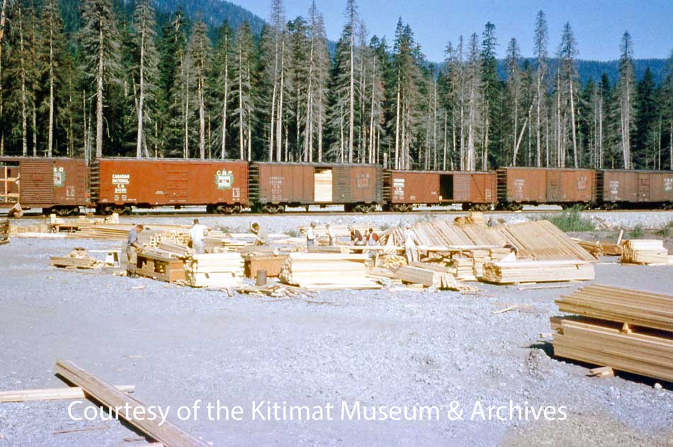
The 2-8-0 was a heavy-duty locomotive designed for hauling freight. All those outbound boxcars filled with ingots and, inbound, as the town was being built, boxcar after boxcar filled with lumber to build the houses and stores of the brand-new town.
Building a town of 8,000 almost overnight required whole CN trains filled with lumber (Walter Turkenburg/ Kitimat Museum & Archives)
The “milk-run” train also serviced Lakelse Lake (where there was a whistle stop in a clearing by the tracks, which I remember from a vacation at Lakesle in the summer of 1957) as well as “stations” (again really just clearings) on the timetable at Wedeene, Dubois, Lakelse and Thunderbird, to pick up loggers, surveyors, fishers and hunters. The trip from Lakelse to Kitimat would have taken one hour and thirty minutes if the train was running on schedule.
Once dedicated passenger service began, CN assigned another steam locomotive, a lighter 4-6-2 Pacific, Number 5000, built in 1913.
As CN was transitioning to diesel, it assigned its last remaining steam locomotives to more remote parts of Canada, like northwest BC. The Pacific, Number 5000, was retired in May 1958. The 2-8-0 Consolidation Number 2129 was scrapped in May 1960.
CN put the station construction out to tender in June 55. The building was completed by the Skeena Construction Company, based in Terrace, before the end of the year.
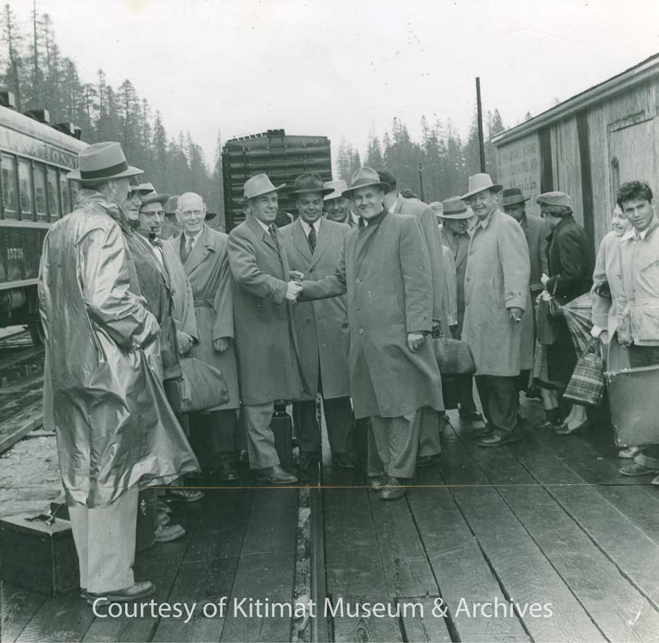
Dignitaries welcome the first daily train to arrive in Kitimat on June 2,1955 . (Northern Sentinel/Kitimat Museum & Archives)
Train was the main mode of travel between Terrace and Kitimat from December 1954 until November 1957 when the highway to Terrace was opened.
Freight operations continued to use the depot for years after passenger traffic ended.
Like many branch line railway stations in North America, the Kitimat station combined passenger and some freight and express operations (most of the freight operations were carried on down the line to Kitimat Concrete Products at the sandhill and on to the Alcan smelter.)
There was soon a lot of traffic in those days people coming in from all over the world to find work. News reports at the time said the three-hour train journey from Kitimat to Terrace was so popular that there was often “standing room only” in the passenger cars.
An undated aerial shot of the Kitimat CN Station and the service centre. A train with six carriages is stopped at the station. (Max Patzelt Collection/Kitimat Museum & Archives)
The trains expanded from a single passenger car to three and later several as demand grew.
The station had a large interior large waiting area with washrooms, a “restroom” and later a small coffee and snack bar was added to the waiting room.
Along a corridor were the depot office and the combined telegraph office and what was called the “repeater room.” Off the corridor were also the station keeper room and conductors’ office. There was a typical bay window operator’s room in the waiting area that looked out onto the tracks.
On the freight side were the express office and the “on hand” (goods for pick up). The original plans had had one door in on the east wall and one door out by the tracks on the west side. Two doors on the north wall added later to meet demand.
A shot of the Kitimat station in the 1950s. (David Wade Collection/Kitimat Museum & Archives)
CBC Radio
On the blue prints for the station there is what is today a cryptic reference to the Telegraph-Repeater room which is the part of the building where we see the Canadian National Logo today. The role of the telegraph – more likely teletype by the 1950s—is obvious. The telegraph office operated for many years after passenger service ended.
It turns out the “repeater” was the first transmitter for CBC Radio in Kitimat. Canadian National Telegraphs operated most non-telephone communications in Canada along its railway lines.
CN had actually had some of the first radio stations in Canada, which were later taken over by the CBC when the Parliament created the public broadcaster.
So, in the Kitimat Station there was a LPRT or a Low Power Relay Transmitter. The “radio” signal came into Kitimat via a CN landline for broadcast. The LPRT was designed to be sited in a location were there was no other coverage or before an actual transmitter was built.
The railway company domination of telecommunications continued in 1967 when CN and CP telegraph services merged to form CNCP telecommunications. That company was later sold to Rogers when the railways got out of the telecommunications business they had founded in the previous century.
Some smaller locations across Canada still have CBC LPRTs where it is not economic to build a transmitter. Today the signal is downlinked from satellite.
CN and the station were also the conduit for secure government communications, including the RCMP. It also transmitted the Canadian Press wire service. Later BC Tel (now Telus) took over many of those functions.
End of passenger service
CN stopped passenger rail service to Kitimat in November 1957 almost as soon as then Highway 25 to Terrace was completed, although the station was still used to coordinate freight and express operations for a few years after that.
In the 1960s, passenger traffic on railways across North America plummeted as the era of the car and air travel became more the normal way to go.
CN used the station for storage in the 1970s and let it deteriorate and at one point it was vandalized. It was briefly owned by the District of Kitimat, but ownership has since reverted to CN.
Today’s train stations were most often just glass and steel, if there were stations at all. Many new stations are glass covered platforms with perhaps a small ticket office (and if passengers are lucky, washrooms).
The Kitimat CN Station is a unique snap shot of Canadian railway architecture and construction from the mid 50s that wasn’t duplicated.
CN has boarded up the building and says it is an “eyesore” and has told the heritage group that it is not structurally sound and should be moved from the site or be demolished.
Architectural assessments
The two architects reported that the station is a one story 3500 square foot structure supported by 2 x 6 fir trusses and 2 x 4 stud walls set in concrete slab. The roof trusses appear to be made of red cedar. As far as both architects could tell (access was somewhat limited) both the fir and reds cedar have survived the previous 62 years largely intact.
The roof was made of aluminum shingles, which were popular at the time as part of what was called “machine age allure” of the “space age” Streamline Moderne and “Googie” forms of architecture. The aluminum shingles, as well as the flashing were well suited for Kitimat because aluminum aged well, and snow would slide off an aluminum roof easier than traditional asphalt shingles.
The problem with the roof is that the sheathing between the red cedar and the aluminum has warped over the decades and that has displaced or heaved most of the aluminum shingles. The fascia will also have to be replaced.
The station hasn’t been heated or properly maintained for many years. That means apart from the structural walls, the rest mostly plywood and plasterboard has deteriorated markedly.
Asbestos
The greatest mistake—in retrospect—and the greatest challenge is the widespread use of asbestos in the building.
It appears that the CN architects and structural engineers in 1955 who designed the station wanted to add to that “machine age allure” by using the “modern” asbestos cladding. Before that almost all the smaller Grand Trunk and CN stations in western Canada had stucco on the exterior walls. In retrospect if CN had stuck with stucco, the station would—allowing for the poor maintenance– probably be in better shape. There are houses in Kitimat with stucco walls that have survived the elements for 50 to 60 years. If the walls were stucco, there would not be today’s cost of removing asbestos.
The asbestos cladding or siding is seen on the CN station, March 6, 2019. (Robin Rowland)
The most obvious use of asbestos is in the cladding or siding on the walls of the station which was a popular material up until the 1980s when the cancer risk from asbestos was realized. In the parts of the station which had linoleum floor—the passenger and office areas—it is likely that linoleum from that era contained asbestos. There is bare concrete floor for baggage express storage and heater rooms, so those are areas where there is presumably no asbestos in the flooring.
Asbestos was also wrapped around many of the building’s mechanical infrastructure and heating ducts. The soffit under the eaves may also contain asbestos.
There is so much asbestos that even if CN wanted to demolish the station the company couldn’t just bring in a backhoe or bulldozer and pull it apart as is done some other cases were there is no asbestos.
Under BC law, the asbestos would have to be safely removed by an asbestos qualified removal company before a demolition permit can be issued.
Renovating also requires a BC qualified asbestos abatement contractor.
In both cases, there has to be a hazardous material survey prior to any work commences. During the work—whether demolition or renovation—there has to be continuous hazardous material and air quality monitoring in the area. (Noting that the station is close to the Kitimat Hotel and service centre businesses)
It appears that CN hasn’t really bothered to undertake a detailed cost benefit analysis. The question is how much cost difference would there be in safely removing the asbestos prior to demolition and the cost of safely removing the asbestos prior to restoration?
Another question that has to be ironed out is who is responsible for the asbestos. CN owns the building and is currently responsible. If, as originally proposed, CN sold the building to the Kitimat Heritage for one dollar, the heritage group would then be responsible. If the heritage group gets to lease the building from CN, then CN, as the landlord, is likely still responsible for the upkeep of the building—a cost that CN apparently, at present, doesn’t want to undertake.
Worksafe BC must be notified of any project where asbestos is being removed (ws0303-pdf-en) PDF
Kitimat faces two choices with the station. To keep it on the current site or to move it elsewhere.
At present, according to the report by Kitimat Heritage presented to District of Kitimat Council, CN would like the building moved away from a potential revenue producing area along the right-of-way.
The Kitimat Heritage group wants the station to remain in place as the role as a train station is part of the Kitimat’s history. As the report says, “The building is not heritage without its provenance—the rail line.”
Both architect Alora Griffin and some building experts say it cannot be moved because the original design placed the load bearing trusses on the concrete pad foundation and therefore there is no floor that would support the station if it was to be moved.
That raises another question, which the far away CN executives have probably never considered because they appear to be clearly unfamiliar with Kitimat infrastructure is where would an intact station be moved to?
The bottle neck would be the Kitimat River/Haisla Boulevard bridge which was built back in 1954, a bridge that urgently requires a seismic upgrade at very least and should be replaced if it is to sustain loads of trucks heading the LNG Canada construction site.
The current District limits for crossing the bridge call for a height restriction of four metres. The maximum clearance on the bridge is 4.2 metres or 13 feet nine inches in height. The maximum weight is 65,000 kilograms or 143,000 pounds. The station is just over nine metres or 29 feet high, which means the station would never fit onto the Haisla Bridge. So why move the station from its current location?
The Haisla Boulevard Kitimat River Bridge seen on March 6, 2019. It is likely impossible to move the station via the bridge to the main Kitimat townsite. If a moving company did attempt the job, all those wires would have to be removed or moved. (Robin Rowland)
If a contractor found a way to move across the Haisla Bridge, however unlikely, by splitting up the building, costs of moving such a building are determined by the size of the building, what work has to be done to the building prior to moving, the distance moved and incidentals such as working with BC Hydro and telecom companies if overhead wires are in the way, cutting down trees if necessary, traffic control or traffic restrictions and other problems a moving company might run into.
So far, no company has been involved that specializes in moving large structures, including heritage structures.
The average minimum cost of moving a residential house in the United States can be $16 a square foot or more, so the minimum cost of moving the 3,500 square foot station—if the sound parts of the structure can actually be moved—would probably begin at least $60,000. Actual costs are usually much higher.
The bridge restrictions mean that the station would have to remain in the service centre anyway.
So why move it?
Another possibility that was raised by local contractors is dismantling the structure, numbering the salvageable parts such as trusses, beams and roof supports and reconstructing the building elsewhere. . One factor is how the trusses would be removed from the concrete base and rebuilt elsewhere in Kitimat.
That latter solution, however, is considered by many to be cost prohibitive. That evaluation would have to be made a qualified restoration architect. A check of available records shows that many–not all– of the CN stations that have been moved are in the prairie provinces where logistics are much easier.
Restoring the station
Kitimat Heritage is asking that the funds CN would have to spend in any case to demolish the building instead be put toward restoration.
The aim of the heritage group is to convert it into a community meeting space, perhaps with a restaurant and a small museum or other guide to Kitimat Heritage.
The heritage group wants a land lease from CN, but the company says a lease at present is impossible due to liability issues. CN has told the heritage group that if was to lease the building it would want $5,000 per year in rent, a $50,000 letter of credit and $10 million in liability insurance.
CN, as the present owner of the station, is, of course, currently solely responsible for any current liability issues that may occur.
CN has told the heritage group that it doesn’t entertain land sales within 100 feet of its right-of-way which is why the railway wants the station moved if it is sold (but as noted above there is no where for the station to go). That is why the heritage group wants a lease.
There are dozens of heritage railway stations across Canada that are still owned by CN and thus have federal protection. (see Note Three below for the list of CN Stations).
It is unlikely that preserving the Kitimat Station would have any adverse effect on CN’s bottom line. In 2018, CN had revenues of $14.321 billion and an operating income of $5.493 billion. The annual report says the railway carried $250 billion worth of goods in 2018 over 20,000 route miles in Canada and the United States. CN buildings were worth $1.186 billion in 2018, according to the report. The Kitimat Station is still on the CN books (and accounting for depreciation as reported in the annual report) and is a miniscule asset.
If an agreement is reached with CN, then the heritage group would have to embark on a fund-raising effort. The next step would be to hire an architect, either a local architect or one who specializes in heritage restoration.
The building would also have to be brought up to current seismic standards and meet the current British Columbia building code for public buildings.
To bring it up to code an architect would have to redesign building and coordinate with electrical, mechanical and structural engineers. Structural engineer would have to asses the condition of the trusses and other parts of the building for possible defects and possible needed upgrades.
To restore the building the customary procedure is to ask three local contractors for a realistic estimate of the cost (not a low bid bid). To be sure, the heritage group should also ask for a bid for a contractor who specializes in restoration. A restoration specialist would likely identify hidden costs or unexpected savings.
What’s next?
The heritage group wants to come to an agreement with CN before proceeding to ask the community for financial and volunteer support.
Although the discussion between the heritage group and CN have been fruitful so far, it appears from CN’s insistence that the station be moved that the company has not bothered to fully research either the heritage of the Kitimat Station nor the geography and geology of Kitimat.
If CN had done a thorough appraisal of the situation, they would know that it is unlikely that the station could cross the Haisla Bridge and thus should stay in situ.
The proposed Pacific Traverse Energy propane project would greatly add to the rail traffic in the area –and also add to CN’s revenue. There are two proposed sites for a rail staging yard, one about three kilometres north of the service centre on Crown Land and the second on Rio Tinto owned track close to the station location—which is probably what CN means when it says the site has “revenue potential.” The current estimate is that the project would require 60 tank cars each day to service an export terminal near Bish Cove.
So far, only pure rumour and speculation have said that the propane project is an impediment to saving the station.
At some point the company should be invited to join the discussion. Since Pacific Traverse Energy has said in its presentation to council that the company is going to embark on a “rigorous program of community engagement” this year and that it is committed to “economic, social, cultural and economical sustainability.” Emphasizing the word cultural means that the company could prove its commitment to the community of Kitimat by taking into consideration the future of the CN Station in any planning and decisions on land use or by helping to pay for station restoration of out a budget of $400 million while ensuring the safety of the station area if the project proceeds.
The cost of restoring the station is likely to be substantial and not only government but corporate funding as well as in kind contributions from local contractors and businesses will be needed to fully restore the station and make it operational as a community centre.
One factor is that the railway line from Terrace and the train station were built by CN on behalf of the then Aluminum Company of Canada, a company that promised CN back in the 50s at least a million dollars a year in revenue. (According to the Bank of Canada inflation calculator one million dollars in 1950 would be 11 million dollars in 2019—which may nor may not reflect how much Rio Tinto actually pays CN). It’s clear that both CN and Rio Tinto have profited from the rail line for the past almost 70 years and it’s time that some of those profits were applied to preserving Kitimat’s heritage.
Kitimat factory town or more?
Most railway heritage buildings and heritage railways around the world are maintained and operated by volunteers usually railway buffs, heritage activists and retired railway employees. There are few, if any, railway employees retired in Kitimat (although there may be some in Terrace or Prince Rupert). This could prove a problem in Kitimat where the same small group of volunteers are engaged in multiple efforts while others in the community seldom contribute. On the other hand, the restoration of the station and its operation as a community meeting place could bring out new volunteers.
The old CN Station on March 6, 2019. (Robin Rowland)
The bigger picture that Kitimat has to decide on is what kind of town will this be in the future?
Back in the nineteenth century, when those iconic railway stations were built across North America, many mining, smelting and logging towns built equally impressive “opera houses” or other culture landmarks that are still preserved today.
While Kitimat never had a grand opera house, there is the station that marks the town’s early settler history.
The LNG Canada final investment decision approval and the growth of Asian markets for hydrocarbon energy (at least for the next few decades) and quality aluminum, means that the industrial base of Kitimat is assured.
Tourism has always been a low priority and culture has been an almost a zero priority.
So, is Kitimat going to be just an industrial town or is it Kitimat going to be more than that with cultural amenities for its residents and to be more than a tourist draw for mostly aging recreational fishers?
Whatever decision is made on the CN station will help decide the road to that future.
A small boy is seen in the photograph of the station wearing a “coonskin cap.” The Disney TV series Davy Crockett was broadcast from December 1954 to February 1955. Two follow up movies starring Fess Parker were Davy Crockett, King of the Wild Frontier, 1955, and Davy Crockett and the River Pirates, 1956. Disney heavily marketed the coonskin cap to small boys, selling at one point 5,000 a day in the United States. Most were made of faux fur. Although Kitimat did not have television until years later, the cap likely dates the photo to the summer or fall of 1955, the height of the coonskin cap craze. Wikipedia.
Note 2
CP 2-8-0 3716 at Kettle Valley. (Canadian Model Railroads/Wikipedia)
You can see a Canadian Pacific 2-8-0 steam locomotive similar to the CN loco that made the first trip to Kitimat at the Kettle Valley Steam Railway in Summerland.
Note 3
A list of Canadian National (or affiliate) heritage railway stations protected by the federal government. This list does not include stations owned by VIA Rail, Canadian Pacific or smaller Canadian Railways. There should be no reason that Kitimat’s station cannot join this list. (The George Little House station in Terrace was not originally a railway station but a heritage house that was moved to the trackside as a VIA station)
British Columbia
Kamloops
Kelowna
McBride
Prince Rupert
Smithers
Vancouver Alberta
Jasper Saskatchewan
Biggar
Humboldt
Melville
Moose Jaw
North Battleford Manitoba
Churchill
Dauphin
Gillam
McCreary
Neepewa
Portage la Prairie
Rivers
Roblin
The Pas Ontario
Alexandria
Barrie
Auroa
Belleville
Brampton
Brantford
Casselman
Chatham
Cobourg
Comber
Ernestown
Fort Frances
Galt/Cambridge
Georgetown
Guelph
Hamilton
Hornepayne
Kingston
Kitchener
Leamington
Maple
Markham
Nakina
Newmarket
Niagara Falls
North Bay
Orillia
Owen Sound
Parry Sound
Port Hope
Prescott
Sioux Lookout
St. Thomas
Stratford
Toronto Union Station
Woodstock Quebec
Amqui
Clova
Joliette
Macamic
Matapédia
Mont-Joli
Montréal
New Carlisle
Port Daniel
Saint-Hyacinthe
Saint-Pascal
Sainte-Anne-de-la-Pérade
Sayabec
Senneterre
Shawinigan
Sherbrooke New Brunswick
Edmunston
Grand Falls
Sackville
Sussex Nova Scotia
Amherst
The District of Kitimat is very pleased with the decision that the BC government issued today removing some of the barriers associated with the establishment of an LNG industry in BC. This will promote access for natural gas from BC to be exported as LNG to international markets. This would be a significant boost for the North West, the province, and Canada as a whole.
This is a positive step forward for the LNG industry in BC, and the District of Kitimat is looking forward to working with the BC Government, LNG Canada, First Nations groups, other stakeholders as well as the Federal Government to move toward a positive final investment decision in 2018.
Michael Dewar
Director of Economic Development
News release from BC Premier John Horgan on his government’s LNG policy
For Immediate Release
March 22, 2018
Office of the Premier
NEWS RELEASE
New framework for natural gas development puts focus on economic and climate targets
VICTORIA – As part of a new approach to natural gas development, the British Columbia government is overhauling the policy framework for future projects, while ensuring those projects adhere to B.C.’s climate targets, Premier John Horgan announced today.
“Our new approach welcomes investment that puts our province’s people and future first, and rejects the old ways of resource development at any cost,” Premier Horgan said. “Our obligation is to the people who call British Columbia home, and our job is to get the best deal for them and the generations that follow.”
Under the new approach, all projects should:
* Guarantee a fair return for B.C.’s natural resources.
* Guarantee jobs and training opportunities for British Columbians.
* Respect and make partners of First Nations.
* Protect B.C.’s air, land and water, including living up to the Province’s climate commitments.
These four conditions form the basis for government’s discussions with LNG Canada, which is moving toward a final investment decision on a project that, if approved, would be the largest private-sector investment in B.C. history. This project would see the construction of a natural gas pipeline from northeast B.C. to Kitimat, where a new terminal will process and ship LNG to Asian markets. It is expected to create up to 10,000 construction and up to 950 full time jobs in northern B.C.
“No premier or government can dismiss this kind of critical economic opportunity for the people of British Columbia,” Premier Horgan said. “But neither will we turn our back on our commitment to climate targets, or our path to reconciliation with Indigenous peoples.”
At the centre of the discussions with LNG Canada is a revised fiscal framework that is designed to put natural gas development on a level playing field with other industrial sectors, accessing the same fiscal policies and working within the same overall B.C. framework to achieve greenhouse gas (GHG) reductions.
The new framework, to which LNG Canada will be subject, provides:
* Relief from provincial sales tax (PST), in line with the policy for manufacturing sectors, subject to repayment in the form of an equivalent operational payment.
* New GHG emission standards under the Clean Growth Incentive Program, announced in Budget 2018.
* General industrial electricity rates consistent with other industrial users in B.C.
* Elimination of the LNG income tax that had required LNG-specific tax rates.
“The LNG Canada proposal has the potential to earn tens of billions of dollars and create thousands of jobs for British Columbians over the life of the project,” Premier Horgan said. “It’s a private-sector investment that could benefit our province for decades to come, but not at any price – we need to make sure the values British Columbians believe in come first.”
The Premier said his government will also expect the LNG Canada project to fit within the goals of the Province’s climate-change plan and, specifically, its legislated GHG reduction targets.
“We committed, during the election campaign, to reduce our greenhouse gas emissions by 40% below 2007 levels by 2030, and by 80% by 2050. That remains our goal,” Premier Horgan said.
“We cannot achieve the necessary reductions in greenhouse gas emissions and do our part in protecting the global environment without a significant shift to a low carbon economy. The work for all of us – in government, business, labour and beyond – is only just beginning. And all resource development proposals must be considered within the context of our global commitment to protecting our air, land and water.”
With B.C.’s new fiscal framework provided to LNG Canada this week, it is anticipated the company will make a final investment decision sometime before the end of this year.
BACKGROUNDER 1
Climate action in British Columbia
On April 1, 2018, the carbon tax will increase by $5 a tonne annually, until 2022.
Increasing the carbon tax meets the requirements set out by the federal government’s pan-Canadian climate framework. Rebates will go to a majority of British Columbians.
However, increasing the carbon tax alone will not enable B.C. to meet its long-term greenhouse gas-reduction goals of 40% below 2007 levels by 2030, and 80% by 2050. Significant new climate-action initiatives will be required in order for B.C. to meet these 2050 legislated targets, while encouraging strong economic growth. To ensure an interim target, new legislated targets for 2030 will be introduced later this year. Specific targets for each of the industrial, transportation and building sectors will also be established.
Meeting climate targets will not be easy and will require a concerted effort across all sectors to make the transition to a low-carbon economy. The addition of emissions from LNG will increase this challenge but government is committed to taking the steps necessary to achieve B.C.’s climate goals.
Specific Measures:
* A portion of the carbon tax revenue, paid by large industry, will fund a rebate program to incent the use of the greenest technology available in the industrial sector, including the natural gas sector, to reduce emissions and encourage jobs and economic growth. Some of the revenue will also go into a technology fund, to help spur new, clean technologies in all sectors, to make sure they fit within B.C.’s climate plan.
* The Climate Solutions Clean Growth Advisory Council (CSCG), established in October 2017, is supporting government’s goal of reducing carbon pollution, preparing for the impacts of climate change and growing a sustainable economy. The CSCG is comprised of community leaders from across British Columbia, including representatives from First Nations, local government, industry, environmental organizations, academia and labour.
* The CSCG is providing advice on actions and policies to achieve significant greenhouse gas reductions, while taking advantage of opportunities for sustainable economic development and job creation.
* Immediate priorities for the CSCG include achieving emissions reductions in the transportation sector, developing pathways to clean economic growth, as well as policies to support the competitiveness of B.C.’s emissions-intensive and trade-exposed industries.
* Government is working to develop a framework for fugitive emissions that match the federal government’s target of a 45% reduction by 2025.
* Government is examining every opportunity to reduce emissions from slash burning by providing alternative economic usage for slash where available.
* Government has initiated a scientific review of hydraulic fracturing aimed at ensuring that industry in B.C. operates according to the highest-possible standards.
BACKGROUNDER 2
British Columbia establishes new framework for natural gas development
Natural gas has a key role to play to provide clean, reliable, affordable and less-carbon-intensive options to global energy markets.
British Columbia has a vast supply of low carbon-intensive natural gas resources in places like the Montney Basin, and has been developing them to support economic growth and job creation at home for decades. B.C. natural gas is an important transition fuel that can help B.C. move to a lower-carbon economy.
While B.C. has been exporting natural gas to U.S. markets for decades, it has an opportunity to export the same fuel to other jurisdictions. To that end, government will introduce a fiscal framework that will provide fair returns to both British Columbians and investors, as well as a climate strategy that will allow B.C. to meet its legislated climate targets.
To ensure British Columbia does it better than anybody else in the world, the provincial government has four key conditions to ensure British Columbians benefit from any proposed LNG development. They are:
* Guarantee a fair return for B.C.’s natural resources.
* Guarantee jobs and training opportunities for British Columbians.
* Respect and make partners of First Nations.
* Protect B.C.’s air, land and water, including living up to the Province’s climate commitments.
Emerging LNG Proposals
Despite the cancellation of Pacific Northwest LNG, Aurora and Woodside project proposals, several other LNG proponents have expressed renewed interest in developing projects in BC.
LNG Canada
LNG Canada’s proposed Kitimat project, should it proceed, represents a very significant economic opportunity for British Columbia – a project that involves one of the largest private sector developments in B.C. history.
Shell and its joint-venture partners have worked constructively to satisfy the provincial government’s conditions for LNG, and British Columbia expects LNG Canada will continue to do so moving forward.
LNG Canada is also working to achieve global leadership in low-emissions technology and operations.
Kitimat LNG
Chevron and its partners have expressed continued interest in developing its project in northern B.C. and is focusing on the use of new low-emissions liquefaction technology.
These come as the Province is completing a climate-action strategy in place that meets the Province’s greenhouse gas-reduction targets – to reduce B.C.’s greenhouse gas emissions by 40% below 2007 levels by 2030, and by 80% by 2050.
New Framework
The B.C. government has developed a new framework aimed at ensuring British Columbians receive a good return for their natural gas resource and proponents receive a reasonable return on investment.
As part of this work, British Columbia and LNG Canada jointly conducted a financial analysis of the LNG Canada project. This analysis corroborated evidence and information from internationally recognized LNG analysts that B.C. has a competitiveness issue and formed the basis of a mutual understanding upon which the Province is prepared to commit measures that will increase the competiveness of British Columbia’s LNG industry.
These measures provide a framework for other industries in British Columbia in similar circumstances – they are not exclusive to the LNG industry or LNG Canada.
As it pertains to LNG Canada, the measures detailed below will only be implemented if the proponents are able to conclusively decide on or before Nov. 30, 2018, to proceed with the construction of the LNG facility and associated investments. These measures below would apply to the entire LNG sector.
1. New Operating Performance Payments
Under current legislation, proponents constructing significant manufacturing facilities would receive a PST exemption on input costs, whereas those proposing to construct LNG facilities would not.
Under the new framework, The B.C. government will exempt LNG Canada from the provincial sales tax (PST), on the construction of their initial proposed facility. This will be conditional on LNG Canada entering into a separate agreement with the province whereby LNG Canada will pay annual operating performance payments over 20 years, a total amount equivalent to what LNG Canada would have otherwise paid in PST during the initial facility construction period.
This framework will be available to all proponents constructing significant manufacturing facilities in the province.Clean Growth Incentive Program
2. The provincial government recognizes that energy-intensive trade-exposed industries, including the natural gas sector, face unfair competition when competing globally with jurisdictions that do not impose carbon taxes. Proponents who make a final investment decision to proceed will be subject to the new Clean Growth Incentive Program, announced by the provincial government in Budget 2018. A benchmark for world-leading clean LNG production will be established as part of this program, replacing existing requirements under the current Greenhouse Gas Industrial Reporting and Control Act.
3. Industrial Electricity Rates
Proponents who make a positive final investment decision will receive the general industrial electricity rate charged by BC Hydro. This is the same rate paid by other industrial users in British Columbia.
4. Removal of LNG Income Tax
The existing LNG income tax is not the most efficient and effective tool for generating returns to British Columbia. It is cumbersome to administer and has led to uncertainties. Government intends to introduce legislation to repeal this tax and instead government will utilize a number other tax and royalty measures under its new fiscal framework, to ensure that British Columbia gets a fair return for its natural gas resource.
New Approach to LNG
As part of establishing a new fiscal framework, the provincial government will take steps to improve the transparency and consistency with which it assesses industrial development opportunities. To that end, government intends to introduce legislation to repeal the Project Development Agreement Act, passed by the previous government, to tie the hands of future governments with respect to the rules governing LNG projects. These measures effectively indemnified proponents against changes. Government will also review and potentially cancel or repeal other LNG measures established by the previous government.
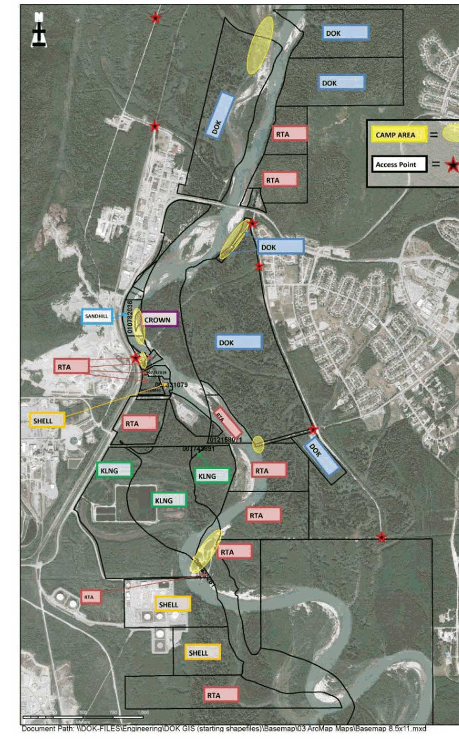
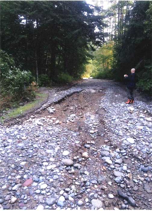
THE RIVERBANK PAPERS: After the flash flood on September 11, 2017, Northwest Coast Energy News filed Freedom of Information/Access to Information requests with a number of provincial and federal agencies who have jurisdiction over the Kitimat river and riverbank camping. The first response to the FOI request is from the Ministry of Forest, Lands and Natural Resource Operations & Rural Development.
A preliminary assessment by the British Columbia Ministry of Forest, Lands and Natural Resource Operations & Rural Development indicates that the District of Kitimat can regulate access to camping on the Kitimat River bank because although the shoreline is on Crown Land, the camping area is within the boundaries of the District.
One of the possible policies that the District staff is considering is allowing only “day access” to the riverbank.
An email on October 11, from Liz Williamson, a senior policy analyst in the ministry’s Land Tenure Branch to Gwen Sewell, the District’s Director of Planning and Community Development, reads:
Permission does not apply to Crown Land within a municipality—as a result even in the absence of zoning/bylaws, any camping that does occur is technically in non-compliance with the permission and therefore could be subject to enforcement action under the Land Act.
Williamson notes that the province likely will have to be involved.
Ultimately that does rely on provincial resources and it looks like DOK would want a greater role in the use and ability to locally enforce the use as you have mentioned zoning and associated bylaws would likely be a course of action you could consider.
Williamson went on to write:
I’m waiting to hear back from one of my more experienced colleagues but I am not aware of any specific limitation to DOK creating bylaws to regulate public recreational use of vacant Provincial land within the municipal boundaries, so long as it doesn’t conflict with a government interest.
She added that the laws and regulations are complex and advised the District to get legal advice. Then she added the District should have “upfront discussions with appropriate provincial authority to ensure that the bylaws do not conflict with existing policy/legislation or other agency interests.”
Right after the flash flood both Sewell and District of Kitimat Chief Administrative Officer, Warren Waycheshen, exchanged emails with officials of both the Ministry of Lands and Forests and the Ministry of the Environment asking first if the province would have any objections to a proposed plan to put gates on municipal land to limit access to the riverbank. Council later put the gate plan on hold.
The emails quoted provincial land use permission policy that says
“Crown permission to use land requires the activity must abide by and comply with all applicable, regulations and bylaws.
And
Before any person may rely on the Permission they must ensure that the activity is taking place on unencumbered Crown land. The Crown land must not be within
A Protected Area includes Ecological Reserves, Parks and Conservancies
Municipality
In his email to Cam Bentley, Resource Manager for the Skeena Lands district, Waycheshen asked if the province was interested in some form of joint administration of the riverbank and if the ministry was interested in joining the working group.
Sewell sent a similar email to Williamson noting,
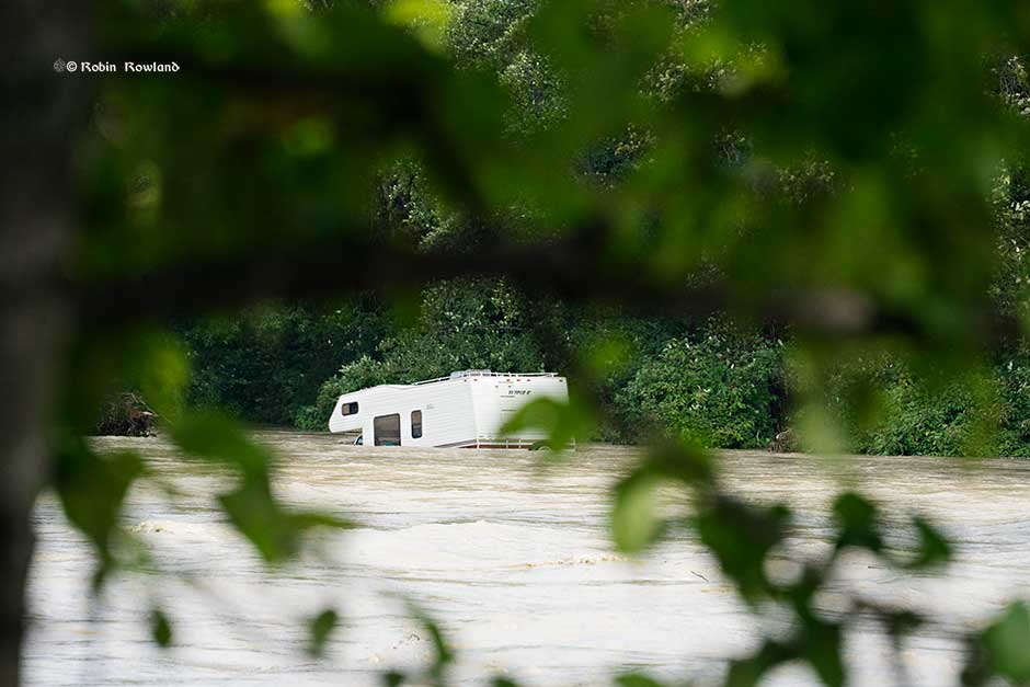
Camping has been occupying the banks of the Kitimat River—opposite a municipal campground called Radley Park—for decades….This had been a somewhat divisive local issue (it’s no cost and traditional use, grey water, residual garbage, human waste, blocking river access for day users etc. and there is a new willingness to consider regulation or prohibition of camping following a flash flood that required a dangerous multi-force rescue effort to save 14 campers and resulted in significant property loss (RVs, vehicles and camping equipment). As camping is “unregulated” the first responders had no idea how many people were in danger or where to look for campers.
Sewell went on to say:
Given…municipal authority to regulate land use by zoning, I believe Kitimat Council may use their zoning power to limit all or selected land along the Kitimat River to “day use only.” I am far from certain this will be the course of action Council will choose to pursue. For now, we only want to identify possibilities.
Williamson replied to Sewell saying that it was good there was no loss of life in the flood. She noted the Keremeos had been going through a similar situation but that village’s problem was that, unlike the District of Kitimat, the camping was outside the municipal boundaries of the village.
KEEP THE RIVERBANK PAPERS INVESTIGATION GOING.
These days filing Freedom of Information and Access to Information requests is much more expensive than it was in the past. It is part of obstruction of freedom of information by all levels of government. One agency wants $900 for their files on the Kitimat River camping issue. That is currently under appeal. Donations (see right hand column) will help the residents of Kitimat know more about what is happening on the camping issue.
Map showing the various jurisdictions along the Kitimat River that the District submitted to the province (District of Kitimat via BC FOI)
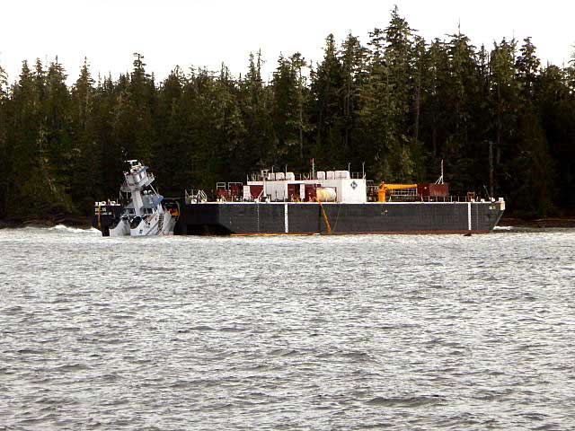
The second mate of the tug Nathan E. Stewart fell asleep on watch when the tug grounded off Bella Bella, on October 13, 2016, according to an investigation report released by the United States National Transportation Safety Board.
The NTSB also said “Contributing to the grounding was the ineffective implementation of the company’s safety management system procedures for watchstanding.”
The Nathan E. Stewart was pushing, not towing the barge, as the NTSB report notes:
The JAK system the tug used to push the barge (NTSB)
The tugboat Nathan E Stewart and the tank barge DBL 55 were connected through the JAK coupling system.1 Controlled from a panel on the tugboat’s bridge, this system uses a 16-inch-diameter, high-strength steel pin pneumatically actuated on each side of the vessel’s bow to lock the vessel into a fitted socket plate welded to each side of the barge’s inner notch. The plates have multiple sockets that run vertically, which allows the tugboat to position itself within the notch to accommodate changing barge drafts as well as to prevent, or minimize, the horizontal movement between the two units.
The NTSB says the grounding of the tug caused about $12 million US in estimated damage to the tug itself and the barge it was pushing.
The Nathan E. Stewart and barge on the rocks (RCMP/TSB)
The Nathan E Stewart spilled 29,000 gallons of fuel and lube oil, released into the ocean off Edge Reef, off Athlone Island in Seaforth Channel in the traditional territory of the Heiltsuk Nation.
Although no petroleum products were released from the empty fuel barge, a subsequent marine survey found that post accident survey of the DBL 55 found that the barge’s external double hull was significantly damaged from its bow completely aft to the skegs on the stern. There were multiple areas where the hull plating had been inset and penetrated. Some of the framing also had been damaged, but none of the inner steel plating comprising the bottom, sides,or top of the cargo tanks had been breached. The JAK socket plates on the inside of the barge’s notch showed slight damage,with the second recess(fromthe bottom up) on both socket plates indicating scarring and heavy contact. Repair costs for the barge were estimated at $5.6 million.
Prior to thegrounding, all the vessel’s vital systems were functional, and there were noindications of a mechanical failure thatmay haveled to the accident.
The NTSB says the tug was on autopilot when the second mate fall sleep on watch and it missed course correction near Ivory Island. The tug had a computerized electronic chart system (ECS) on board that should have sounded an alarm when the way point for the course correction was missed, but the mate told the NTSB, the tug was not using that navigation tool on the night of the accident. According to the second mate, it was
normal practice for the navigation team to not utilize that tool.
The NTSB report says had the ECS been utilized, the ECS would
have entered into an alarm mode after the second mate missed the port course change required near Ivory Island. Based on time, speed, and distance calculations, the alarm would have activated at approximately 0055 and thereby provided ample time for the second mate to take
corrective action to return the Nathan E Stewart to the intended track.
As related in Gordon Robinson’s Tales of the Kitamaat, the First Peoples living on the coast of what is now British Columbia ventured up what is now called Douglas Channel perhaps from either Bella Bella in Heiltsuk traditional territory or from Prince Rupert in Tsimshian traditional territory.
The young men on the expedition up the Kitimat Arm spotted what they thought was a huge monster kilometres ahead with a large mouth that was constantly opening and closing. The sight was so terrifying that the men fled back to their homes and dubbed the Kitimat Arm as a place of a monster.
Later a man named Hunclee-qualas accidentally killed his wife and had to flee from the vengeance of his father-in-law. Knowing he had to find a place where no one could find him, he ventured further up the Kitimat Arm. There he discovered that the “monster” was nothing more than seabirds, probably seagulls, perhaps feasting on a spring oolichan run.
He settled along the shore of what is now the Kitimat River and found a land of plenty, with fish, seals, game as well as berries and other natural products of the land. Eventually he invited others to join him, which began the Haisla Nation and he became their first chief.
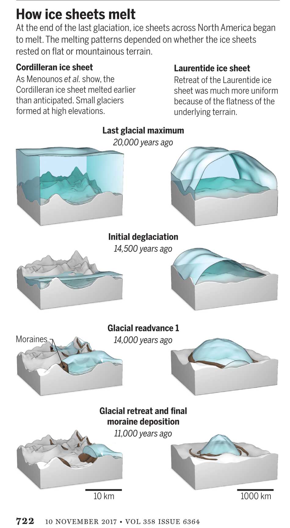
Let’s examine the new evidence so far.
Settlement along the coastal “kelp highway” between 18,000 and 16,000 years ago, followed by a warm spell 14,500 years ago
It’s now fairly certain that the First Peoples first began to settle along the coast by following the “kelp highway” perhaps as early as 18,000 years ago and certainly by 14,000 years ago. Haida Gwaii was ice free, except for some mountain glaciation as early as 16,500 years ago. At about 14,500 years ago there was a warming spell which forced the glaciers to retreat, brought higher sea levels and the arctic like tundra ecosystem would have been replaced, at least for a time, by forests. There is the discovery of a Heiltsuk settlement dated to 14,000 years ago. At that time almost all of the coast would have been free of glacial ice but there were still glaciers in the fjords, including the Kitimat Arm which would mean there could be no permanent settlement in the “inland coast” and the interior.
(Science)
The cooling period from 14,000 to 11,700 years ago confines settlement to the coast
The cooling periods (with occasional warmer times) from about 14,000 years ago to about 11,700 years ago meant that settlement would largely have been confined to the coast for about two and half millennia. The culture of the coastal First Peoples would have been well established by the time the glaciers began the final retreat.
(Remember that it is just 2,000 years from our time in 2017 back to the height of the Roman Empire under Augustus Caesar).
It is likely that the cooling periods also meant that some descendants of initial settlers likely headed south for relatively warmer climates. Rising sea levels meant that the initial settlement villages would likely have been abandoned for higher ground.
A second period of rapid warming 11,700 years ago which opens up the interior fjords and valleys
At the end of what geologists call the Younger Dryas period, about 11,500 years ago, the climate warmed, the glaciers retreated further, in the case of Kitimat, first to what is now called Haisla Hill, then to Onion Flats and finally to Terrace.
Large glacial sediment river deltas filled with fresh melt water from retreating ice
The most important confirmation of the story of Hunclee-qualas’s exile is the account of the monster, the birds and the oolichan run.
The new scientific evidence, combined with earlier studies, points to the fact that the glacial melt water carried with it huge amounts of glacial sediment that created vast river deltas in coastal regions of the Northern Hemisphere.
That means around 10,000 years ago, when the Kitimat Valley was ice free and the new forest ecosystem was spreading up the valley, the Kitimat River estuary was likely to have been much larger than today. It could have been a vast delta, which would have quickly been repopulated with fish, including salmon and oolichan. That rich delta ecosystem could have supported a much larger population of seabirds than the smaller estuary in recent recorded history.
Snow geese by the thousands in the Sacramento-San Joaquin Bay Delta/ CrunchySkies/Wikimedia Commons/Creative Commons License
The story of the monster those first travelers saw far off is highly plausible. Even today in huge, rich deltas elsewhere in the world, seeing hundreds of thousands of birds in flight over a wetland is fairly common. (For a description of what a Kitimat River delta may have been like thousands of years ago, see KCET’s story on the Sacramento-San Joaquin Bay Delta and what that delta was like 6,000 years ago)
The First Peoples had had well established communities for up to four thousand years before the Kitimat Valley’s metres of thick ice had melted away. For the first period, while the ecosystem regenerated, for the people of the coast coming up Douglas Channel to the valley would not have been worth it, there would be little to find in terms of fish, game or forest resources.
A Snow Goose flock near the Skagit River Delta, WA./ Walter Siegmund/Wikimedia Commons
The change from tundra to a rich forest environment
Eventually as the forest regenerated, the streams filled with salmon and oolichan; the bird population including gulls, geese and eagles, found a new feeding ground; bears, deer and other animals arrived. The Kitimat region would have been an attractive place to explore and hunt. It may be the monster story did keep people away until Hunclee-qualas had to find a place to hide and discovered a new home just at a time that might be called an ecological optimum with new forests stretching back along the valley to what is now Terrace.
The river delta shrinks back to the current estuary
If a vast Kitimat River delta did stretch further down the Channel than it does in 2017, it likely shrank back in the subsequent millennia. Eventually the mass of glacial sediment that came downstream after the retreat of the ice would diminish, but not stop entirely. The estuary is still rebuilt from sediments washed downstream but that sediment doesn’t match other rich deltas elsewhere such as the Nile in Egypt. With that regeneration of the delta slower and smaller than in the first centuries of Haisla settlement, at the same time the land surface rebounded from the weight of the ice, perhaps creating the Kildala neighborhood. The ocean level rose, drowning and eroding part of the old delta, creating the estuary we know today.
As the authors of the paper on the First Peoples’ settlement note, most of the archaeological evidence of early coastal settlement is now likely many metres below the surface of the ocean but deep ocean exploration may uncover that evidence. As the scientific team on the second paper say, they are now working on detailed studies of the glacial retreat from the coastal mountain region which may, when the studies are complete, change the timeline
While waiting for further evidence from archaeology and geology it is safe to say that the stories of the monster and later Hunclee-qualas’s discovery of the Haisla homeland are even more compelling than when Gordon Robinson wrote Tales of the Kitamaat. We can now speculate that there was once, stretching from Haisla Hill far down the Channel, a vast, varied rich, river estuarine delta that supported hundreds of thousands of seabirds, which if they took the wing in unison, would have made those unwary travelers millennia ago, really think that there was a giant monster waiting to devour them at the head of the Kitimat Arm.
If some travellers, perhaps about 12,000 years ago, had headed up what is now called Douglas Channel, around the north end of Hawkesbury Island they likely would have seen a glacial retreat driven by a warming planet, something very familiar to the television viewers of 2017, video of 21st century coastal Greenland, where massive glaciers are calving ice bergs into the ocean.
The history of rapid glacial retreat over several thousand years from the interior and coastal British Columbia at the end of the last Ice Age is now becoming a crucial indicator of what may happen to both Greenland and the Antarctica. Under the current ice sheets both Greenland and parts of Antarctica are mountain ranges similar to those here in British Columbia. According to new research published to today in Science, that may indicate what could happen as those ice sheets melt and how that will affect volatile climate change.
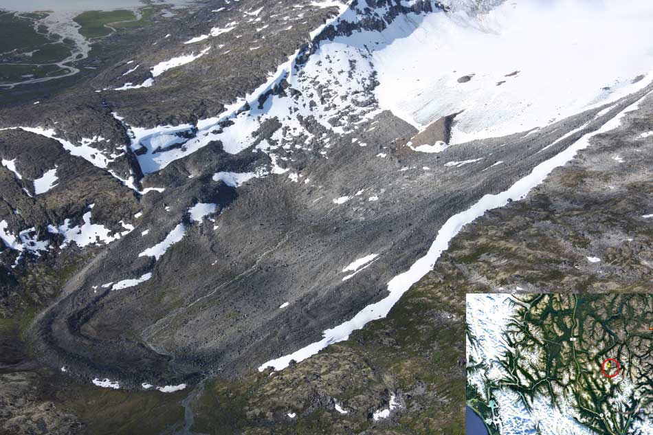
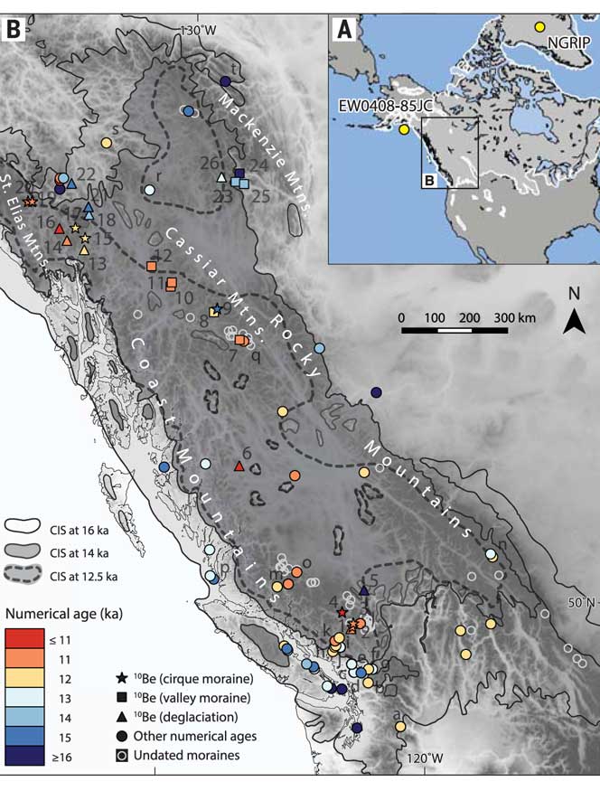
The paper written by Brian Menounos of the University of Northern British Columbia and co-authors indicates that the glacial retreat in BC was faster than previously believed, beginning about 14,000 years ago. That left some parts of coastal and western BC ice free, rather than beginning 12,500 years ago as previously estimated. The last Ice Age probably reached its maximum coverage about 20,000 years ago.
One of the cirque moraines at the end of a glacier studied by Brian Menounos and his team. It is in northern British Columbia just south of the Yukon border. ( Brian Menounos/Science plus Google Earth)
The decay of the ice sheet was complex, partly due to presence of mountainous terrain and also because Earth’s climate rapidly switched between cold and warm conditions during the end of the last Ice Age.
One of the factors that may have triggered a climate change back to colder conditions was a massive outflow of cold, fresh water from coastal British Columbia, which may have affected ocean currents.
What geologists call the Cordilleran ice sheet once covered all of present-day British Columbia, Alaska and the north Pacific United States. How the Cordilleran ice sheet responded to climate change was different from the Laurentide ice sheet which covered the flatter terrain (prairie and the Canadian Shield) of central North America. The Cordilleran ice sheet is about the same size as the current Greenland ice sheet.
“Our work builds upon a rich history of collaborative research that seeks to understand when and how quickly the Cordilleran ice sheet disappeared from Western Canada,” Menounos says. “Projected sea level rise in a warming climate represents one of the greatest threats to humans living in coastal regions. Our findings are consistent with previous modeling studies that show that abrupt warming can quickly melt ice sheets and cause rapid sea level rise.”
One of the co-authors of the paper is John Clague, now a professor emeritus of Earth Science at Simon Fraser University who studied the glaciation patterns in the Kitimat valley and Terrace in the 1970s when he worked for the Geological Survey of Canada.
Earlier researchers, including Clague, relied on radiocarbon dating to establish when the ice sheets disappeared from the landscape. The problem is that radiocarbon dating may not work in higher alpine regions where fossil organic matter is rare (above the tree line).
Menounos and the researchers used surface exposure dating – a technique that measures the concentration of rare beryllium isotopes that accumulate in quartz-bearing rocks exposed to cosmic rays – to determine when rocks first emerged from beneath the ice. If the rocks are under an ice sheet that means they are not exposed to cosmic rays, and thus measuring the beryllium isotopes can indicate when the retreating ice exposed the rocks to the cosmic rays.
The scientists studied small “cirque moraines” found only beyond the edge of modern glaciers high in the mountains, and valley moraines.
The alpine cirque moraines could not have formed until after the Cordilleran ice sheet had retreated. Menounos and his team show that several alpine areas emerged from beneath the ice sooner than previously believed. Then once the mountain peaks emerged from the thinning ice, new, smaller glaciers grew back over the high-elevation cirques at the same time that remnants of the ice sheet “reinvigorated” in the valleys during subsequent climate reversals
Most of the work of the team was done in the interior of British Columbia, the Yukon and Northwest Territories. Menounos says that new, similar work is being done on the mountains of the coastal region which will be published when the research is complete.
At its maximum, the Cordilleran ice sheet likely extended from what is now the mainland coast across Hecate Strait to the east coast of Haida Gwaii.
Starting about 14,500 years ago, the planet entered a phase of warming, with the average temperature rising about 4 degrees Celsius over about a thousand years. The Cordilleran ice began to thin rapidly leaving what the paper calls a “labyrinth of valley glaciers,” which then allowed the alpine glaciers to re-advance.
Diagram from Science shows how the glaciers retreated at the end of the last Ice Age, with the mountainous Cordilleran ice sheet behaving differently from the central North American Laurentide ice sheet (Science)
The scientists have suggested the rapid ice loss, beginning 14,500 years ago, came relatively quickly in geological time, perhaps just 500 years. That may have then contributed to subsequent Northern Hemisphere cooling through freshwater rushing into the ocean. That melt water disrupted the overturning ocean circulation of cold and warm water. That led to a new cooling period that lasted from about 14,000 to 13,000 years ago. (Similar to the completely fictional scenario in the movie The Day After Tomorrow, where the cooling happens in days not centuries).
That same outflow could have raised then existing sea levels by two and half to three metres, Menounos says. (The overall sea level on Earth rose about 14 metres by the end of the Ice Age)
Then the climate reversed again, first briefly warming and then in a period that saw another abrupt change back to cooler conditions which geologists call the Younger Dryas, The Younger Dryas occurred beginning about 12, 900 years ago to about 11,700 years ago, when warming began again. The Dryas is named after a wildflower that grows in arctic tundras.
The study indicates that the First Peoples could not have settled the interior of what is now British Columbia prior to the Younger Dryas, but it is likely as was explored in a paper last week in Science that the First Peoples were able to come down the “kelp highway” on the coast by at least 14,000 years ago.
Map of British Columbia showing the extent of the glaciation during the last Ice Age and now the ice retreated. The coloured graphics are where the study was done mostly in the interior of BC and the age of the deposits. KA means kilo-years or thousand years ago. (Science)
So what happened in Douglas Channel?
So what does the new study of glacial retreat mean for the history of Douglas Channel?
John Clague studied the Douglas Channel, the Kitimat Valley and the Terrace area in the 1970s and was one of the co-authors of the current study that provides a new timeline for the retreat of the glaciers on the British Columbia coast.
He says that the timeline from his work in the 1970s with radio carbon dating of fossilized organic material is fairly consistent with the new work by Brian Menounos of the University of Northern British Columbia using the beryllium isotope technique.
The paper, Clague says, is more of a general commentary on the last stages of the decay of the Cordilleran ice sheet.
“At the time we’re taking about in the paper, there was ice in the corridor between Kitimat and Terrace.
“What we see in detail based on the work I did ages ago, is the retreat of the glacier from the Kitimat Arm back to the north towards Terrace [in the Young Dryas ]. It occasionally stabilized and the melting ice discharged a lot of sediment into that marine embayment.
Based on his original work and the new study Clague says at the time, the mountains are beginning to become ice free but there was still ice in the major valleys such as the Skeena Valley and the corridor south of Terrace towards Kitimat.
“They’re overlapping stories.” Clague says.
“The ice sheet hadn’t completely disappeared at the time Brian is focusing on,” Clague says. “His point is that a lot of the mass of the ice sheet appeared to be thinning and through marginal retreat from Haida Gwaii and some of the islands off the mainland back toward the mainland itself. So we’re trying to put a chronology on it, as to the various steps in the glacial decay.”
The work seems to indicate that the final ice sheet retreat happened in four stages around 12,000 to 11,000 years ago. “I was interested in the detailed reconstruction of the ice front tracked north from Kitimat you see a number of periods when it stabilized long enough to build up very large deltas and braided melt water plains,” Clague says.
The first moraine is Haisla Hill in Kitimat, where the glaciers discharged large amounts of sediment into what is now Douglas Channel. The second is the hill leading to what is called Onion Flats, the third is the flat area where the Terrace Kitimat Regional Airport now is and the final stage of glacial retreat created the “terraces’ around Terrace and Thornhill.
“It’s interesting that in this area there was so much sediment discharged into the sea remarkably for the time over which the ice was retreating through the area. It had to have been a major kind of discharge point of water from the ice sheet south from Terrace towards Kitimat otherwise you wouldn’t get that huge amount of sediment deposited probably over a period of a thousand years. Then it retreated again to just north of the airport and anchored there for a while and we found evidence for a final last gasp upstream around Thornhill and that kind of near Terrace.”
“At that time some of the high elevation glaciers were re-energized and readvanced, but it probably didn’t affect the overall health of the ice sheet itself It’s such a big mass of ice that it doesn’t respond quickly to such a brief cooling so what we’ve done in many places is these glaciers actually advanced up against ‘the dead ice’ an ice sheet that was lower in elevation.”
At the times the oceans rose at the end of the Ice Age, there were “sea corridors” between Kitimat and Terrace and also in the Skeena Valley. “So you can imagine there were arms of the sea extending to Terrace from two directions almost making that area which is now part of the mainland an island.” But the region likely never did become a true island, Clague says because as the ice sheets retreated,, they were also shedding large amounts of sediment that would become land area at the same time as the earth’s crust was rebounding once it was freed from the weight of the ice sheet.
Most historians and archaeologists believe that the First Peoples to arrive in North America came down the West Coast on what they now call the “kelp highway.”
Evidence from archaeological sites from the British Columbia coast to the southern tip of South America show that First Peoples had settled on both continents by at least 18,000 years ago, according to authors T.J. Braje at San Diego State University in San Diego, CA; T.D. Dillehay at Vanderbilt University in Nashville, TN; J.M. Erlandson at University of Oregon in Eugene, OR; R.G. Klein at Stanford University in Stanford, CA; T.C. Rick at National Museum of Natural History, Smithsonian Institution in Washington, DC.
The paper also says the DNA genomic data suggests a northeast Asian origin for Native American ancestors some time in the past 20,000 years.
(Science)
One of the key sites cited in the paper is Triquet Island in the traditional territory of the Heiltsuk Nation which has been dated to at least 14,000 years ago. Heiltsuk oral history has marked the island for generations, William Housty a member of the Heiltsuk told CBC News at the time the discovery was officially announced in April 2017, “Heiltsuk oral history talks of a strip of land in that area where the excavation took place. It was a place that never froze during the ice age and it was place where our ancestors flocked to for survival.”
The authors of the review say the new consensus on the “kelp highway” is a “dramatic intellectual turnabout” from the original idea that the first indigenous settlers followed an ice free corridor from a land bridge from Siberia down the centre of North America to form the “Clovis Culture”
The land bridge between northeast Asia and North America, commonly called Beringia, came about when sea levels fell during the last ice age. Although the original Beringia hypothesis has been disputed by some First Peoples, the paper says the Beringia hypothesis is still a factor—but much farther back in time, now about 24,000 years ago.
The paper says:
most archaeologists and other scholars now believe that the earliest Americans followed Pacific Rim shorelines from northeast Asia to Beringia and the Americas.
According to the kelp highway hypothesis, deglaciation of the outer coast of North America’s Pacific Northwest about 17,000 years ago created a possible coastal corridor rich in aquatic and terrestrial resources along the Pacific Coast, with productive kelp forest and estuary ecosystems at sea level and no major geographic barriers
The paper says that kelp resources extended as far south as Baja California, and then—after a gap in Central America, where productive mangrove and other aquatic habitats were available—picked up again in northern Peru, where the cold, nutrient-rich waters from the Humboldt Current supported kelp forests as far south as Tierra del Fuego.
The other sites cited in the paper are
Huca Prieta, Peru 15,000 to 14,500 years ago
Paisley Caves, Oregon 14,000 years ago
Monte Verde, Chile 14,500 years ago
Page-Ladson, Florida 14,500 years ago
Channel Islands California 13,000 years ago
Quebrada Santa Julia and Quebrada Huentelauquén , Chile 13,000 years ago
Quebrada Tacahuay Peru 13,000 years ago
Quebrada Jaquay, Peru 13,000 years ago
In an earlier article in Science in August, Knut Fladmark, a professor emeritus of archaeology at Simon Fraser University who was one of the first to propose a coastal migration into the Americas back in 1979, said: “The land-sea interface is one of the richest habitats anywhere in the world,” noting that early Americans knew how to take full advantage of its abundant resources.
Testing the kelp highway hypothesis is challenging, the scientists say, because much of the archaeological evidence would have been submerged by rising seas since the end of the last “glacial maximum,” about 26,500 years ago.
The earlier that the First Peoples arrived, that means the land they originally settled is now the further offshore from the current coast (land which is now likely also at greater depth under the current ocean). So the review says that finding the evidence means that, “enlarging already vast potential search areas on the submerged continental shelf.”
The authors say:
Although direct evidence of a maritime pre-Clovis dispersal has yet to emerge, recent discoveries confirm that late Pleistocene archaeological sites can be found underwater. Recent discoveries at the Page-Ladson site, in Florida produced 14,500-year-old butchered mastodon bones and chipped stone tools in the bottom of Florida’s Aucilla River.
The report says that “Several multidisciplinary studies are currently mapping and exploring the submerged landscapes of North America’s Pacific and Gulf of Mexico coasts, searching for submerged sites. .
In British Columbia, those studies (pdf) include the discovery by Daryl Fedje, an archaeologist at the University of Victoria and the Hakai Institute of 29 footprints on Quadra Island. A piece of wood embedded in a footprint’s fill provided the radiocarbon date of 13,200 years ago and the spear points lying and a cluster of bear bones at Gaadu Din cave on the Haida Gwaii dated to 12,700 years ago.
The review says that for much of the 20th century, most archaeologists believed humans first colonized the Americas about 13,500 years ago via the overland route that crossed Beringia and followed a long and narrow, mostly ice-free corridor to the vast plains of central North America. There, according to the earlier theories, Clovis people and their descendants hunted large game and spread rapidly through the New World.
This was initially confirmed by twentieth-century discoveries of distinctive Clovis artifacts throughout North America. Some finds associated with mammoth or mastodon kill sites, supported this “Clovis-first” model.
The early studies decided then that “North America’s coastlines and their rich marine, estuarine, riverine, and terrestrial ecosystems were peripheral to the story of how and when the Americas were first settled by humans.”
Now the recent work along the Pacific coastlines of North and South America has revealed that these environments were settled early and continuously, providing a rich diversity of subsistence options and technological resources for New World hunter-gatherers.
A detail of the map from Science shows how off from the current coast the ancient shorelines reached (Science)
At the moment, there is little evidence on the coast so far of the kind of stone tools and fishtail points that had previously provided a road map that archaeologists used to trace the spread of “Clovis” Paleoindians throughout the Americas. Such a roadmap is lacking for “pre-Clovis” sites on the coast.
One proposal is that distinctive stemmed (“tanged”) chipped-stone projectile points, crescents (lunate-shaped), and leaf-shaped bifaces found in Japan, northeast Asia, western North America, and South America could be potential markers of an earlier coastal migration and ties to Ice Age peoples in East Asia.
The problem of finding final proof of the kelp highway is that the First Peoples followed a coastal route from Asia to the Americas, so that finding evidence for their earliest settlements will require careful consideration of the effects of sea level rise and coastal landscape evolution on local and regional archaeological records.
The scientists note that around the globe, evidence for coastal occupations between about 50,000 and 15,000 years ago are rare because of postglacial sea level rise, marine erosion, and shorelines that have migrated tens or even hundreds of kilometers from their locations at the ice age glacial maximum.
They say overcoming these obstacles requires interdisciplinary research focused on coastal areas with relatively steep offshore bathymetry, formerly glaciated areas where ancient shorelines have not shifted so dramatically, or the submerged landscapes that are one of the last frontiers for archaeology in the Americas
District of Kitimat Council voted Monday five to two to create a “working group” of “concerned citizens and community groups” to consider the future of riverbank camping along the Kitimat river. The working group will consider issues such as access to the river, pollution and how to control extended camping along the river.
That vote came after council split five to two again to defeat a motion by Councillor Mary Murphy to stop riverside camping altogether.
A proposal from District staff to put access gates at three locations, the Giant Spruce Road, the Sewage Plant and the Pump House was tabled for the time being. However, the councilors and staff marked the pump house gate as a priority for study by the engineering staff due to concerns that “the risk of fuel, oil and other contaminants (i.e. Illegal dumping ) occurring. This is the source water area for the city’s water supply, reducing access reduces contamination risks.” Staff said that unlike other portions of the riverbank, the District does “have authority under drinking water protection act to protect this area.”
Council also voted to close Hirsh Creek park immediately because the roads at the camping area were washed out by the flood last week.
Councillors noted that many people still go to Hirsch Creek after the gates are closed at the end of the season to walk dogs or hike. This results in a parking jam at the front of the gate and on busy times, cars park on Highway 37 which could endanger pedestrians.
District staff will study moving the park gate down further to a point that the road narrows near the first campsite to allow safe access for dog walkers and hikers.
The main problem facing the District of Kitimat is that most popular sites along the riverbank for campers are on provincially owned Crown land. In 2014, the former BC Liberal government passed a regulation that says people can camp on Crown land for up to 14 days. As some councillors pointed out this restriction regularly abused by some campers who stay on the riverbank for weeks, some apparently camping from Victoria Day to Labour Day.
A detail from the DoK map of who owns the riverbank shows that many of the popular camping sports along the Kitimat River are on provincial Crown land (dark green) while the municipality controls the land away from the riverbank including the access roads (brown). (District of Kitimat)
During the debate it was pointed out that often those camp on the riverbank like to “claim” a camping/fishing spot and try to prevent others from using it. “I know of a couple of fistfights,” Murphy told Council.
As Councillor Rob Goffinet pointed out, whether or not the District could place gates on municipal land to stop access to provincial Crown land would require a legal opinion.
Murphy told Council that she had received emails, blaming Kitimat for “almost drowning” some of the campers. She said that her views may be unpopular among some residents, but added, “I don’t care if I’m unpopular, I want to keep people safe.”
Councillor Larry Walker, who pointed out that he likes of fish along the river, who supported Murphy’s motion told his colleagues to get their act together and “do something about the riverbank.” He later proposed that if council does nothing, perhaps Kitimat should hold a referendum on the future use of the river bank.
The majority on Council were more cautious, while acknowledging problems. They pointed out that the many of the campers both on the east bank and on the west bank at Radley Park patronize local businesses during the summer months.
While there was wide discussion on social media before the council meeting, only three people showed up to give their opinions, mostly concerned about permitting access to the river for people with mobility issues or small children.
There were many comments and questions about how other areas police provincial Crown Land, with some saying that some places restrict access to only a couple of days. However, no one either on Council or staff had any idea of what exactly other locations are doing, if anything.
There were no details of how the working group would operate and who would participate. During the debate it was pointed out that as well as the province, participants would have to include Rio Tinto, LNG Canada and DFO. As well, Council did not set a deadline for the working group to report back.
As Murphy pointed out back in 2014, Fisheries and Oceans refused to attend a Council meeting or make a public presentations on its views of the river bank situation. (DFO snubs District of Kitimat Council for a second time ) while offering to meet with staff “they will continue to meet at an operational level to provide information on DFO’s regulatory role.” That, of course came during the Stephen Harper administration which severely restricted any public participation by the civil service on environmental issues. Whether the Justin Trudeau government has changed that policy remains to be seen.
The campsite road at Hirsch Creek park was washed out in the flood. (District of Kitimat)
Was the rain storm an anomoly?
During the debate, Mayor Phil Germuth, pointed to the sudden onslaught of rain during Sunday and Monday September 10 and 11 and called it “an anomaly” which means that Kitimat should not overreact to the storm.
Environment Canada chart of the spike in the Kitimat River levels, as presented to District Council. (Environment Canada)
Climate science has repeatedly shown that global warming is increasing the odds of extreme precipitation and storm surge flooding. Refusing to acknowledge this impairs our ability to prepare for future extreme weather and endangers American lives and property.
Scientists can now even evaluate how much climate change has increased the odds of individual extreme events, including rainfall and flooding.
As the 2015 American Meteorological Society report quoted by The Times indicates, those unpredictable and extreme events don’t just include floods but the widespread forest fires in Alaska in 2014 and we all know how bad the fire season has been in British Columbia this year.
As Noah Diffenbaugh of Standford University pointed out in The Times
Being smart about managing exposure and vulnerability is critical to reducing risks. But doing so requires acknowledging that global warming is happening, that humans are the primary cause and that the odds of catastrophes like Hurricane Harvey are increasing.