Three studies of the geology of Douglas Channel are near completion and publication, according to Natural Resources Canada. That news comes as studies, released today, warn of a major megathrust earthquake on the fault west of Haida Gwaii.
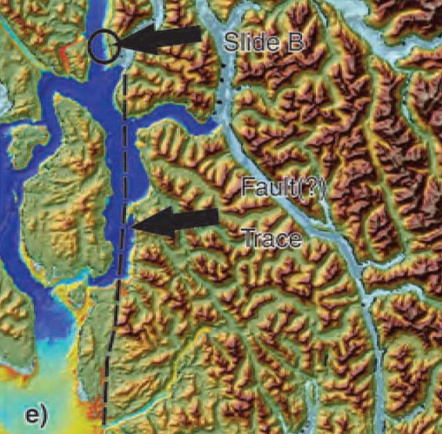
Northwest Coast Energy News asked the Geological Survey of Canada if there were any recent updates available after the agency said that a survey had located a “possible fault” on Hawkesbury Island during studies for the Enbridge Northern Gateway Joint Review Panel.
Natural Resources Canada responded with a statement: “NRCan continues to conduct research studies in the area, including study of possible faults. Three scientific expeditions have been completed on board Coast Guard research ships. The first two reports are in the final stages of editing, and will be published in the coming months. The third expedition was just completed; therefore the third report will be available later.”
More recently there were slope failures nearer to Kitimat. The first slope failure occurred on October 17, 1974, triggering a 2.4 metre tsunami at low tide. Then on April 27, 1975 there was a second slope failure near low tide on the northeast slope of the Kitimat Arm that generated an 8.2 metre tsunami. The 1975 tsunami destroyed the Northland Navigation dock near Kitimat and damaged the Haisla First Nation docks at Kitamaat Village.
Thomas James, of the Geological Survey told Northwest Coast Energy news about the team’s finding on the Haida Gwaii earthquake: “The studies focused on the Haida Gwaii and Craig earthquakes which happened at the Pacific and North American plate boundary, west of Haida Gwaii, so east of Haida Gwaii there’s no comparable plate boundaries that gives rise of historic sieismisticity.”
As well as the fact that recent studies say the mainland margin coastal zone has had very little historical seismicity, it adds no currently active faults have been identified. A study ten years ago identified some very ancient faults which have not been active since the Eocene, about 33 to 56 million years ago.
GPS studies show that in northwestern British Columbia coastal block is moving northeast at the rate of just 5 millimetres a year.
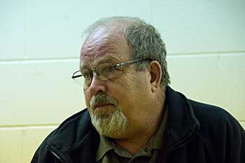
Kitimat Emergency Coordinator Bob McLeod at the earthquake postmortem Oct. 29, 2012 (Robin Rowland/Northwest Coast Energy News)
Studies of the October 2012 magnitude 7.8 Haida Gwaii earthquake show that the region is vulnerable to a “major megathrust” earthquake along a newly confirmed fault line west of the islands.
That earthquake was felt in Kitimat and Kitamaat Village and a tsunami warning was issued within a few minutes.
So have the District of Kitimat, the Haisla Nation Council or Rio Tinto Alcan changed or upgrading their earthquake and tsunami plans in the past couple of years?
Bob McLeod, who recently retired as the District of Kitimat’s emergency coordinator, told Northwest Coast Energy News: “I think we’ve done quite a bit. One of the biggest issues in the first one was trying to get information out. We’ve come a long way on that. Whether you reach everyone or not, that’s another thing, because you never reach everybody. One of the critical things to me is getting the information out so you avoid all this Facebook, Twitter speculating and rumour. The communications aspect has improved a hundred fold.
“We did more work on the mapping and planning. Over the course of the last year, there were a lot of meetings with industry and various stakeholders, discussing emergency preparedness in general but touching on some of these other things as well.
“One of the things we did was to try to set up some shelter points. We have an agreement with the Baptist Church, the Catholic Church and the Seventh Day Adventists. They’re strategically located and could be gathering points for the various neighborhoods if necessary.
“We’ve also done quite a lot of work on Riverlodge as a group lodging centre, thinking in terms of an earthquake where there may be damage and you have to move people.
“We did look at the evacuation planning and we’ve had a couple of exercises involving that, looking strategically about how can you move people from certain neighborhoods, asking which neighborhoods would be at the most risk if you ended up with a tsunami situation.
As for tsunamis, McLeod said, “From everything we’ve heard and been told, tsunamis in extremely deep water like that is not going to be as dangerous as one in shallower water, but the possibility is still there.
“The thrusts are the killers when it comes to tsunamis, but there is a very good warning system on the tsunamis. We do get very very rapid feedback on the earthquakes.
“The only danger in that regard is if you have a severe earthquake and you have part of a mountain drop into the salt chuck, you’re going to get a massive wave and you’re going to get no warning whatsoever, like the Moon Bay collapse in the seventies.
“The emergency plan is in good shape. We scheduled a number of exercises last year through training programs.
“One of the things I personally push is personal preparedness. I think as a community, we fail greatly at that. That was evident even during the snowstorm. People are not just prepared to look after themselves, it’s unfortunate. You just have to keep chipping away.”
Last week, Northwest Coast Energy News asked Rio Tinto Alcan and the Haisla Nation Council if either could comment on updated earthquake or tsunami response plans. So we have received no answers.
Climate change, which will raise ocean temperatures and more carbon dioxide in the atmosphere which will increase the acidification of the oceans will have the greatest affect on the intertidal zones—and a key indicator species, crabs and similar creatures.
A study by San Fransisco State University published today in the Journal of Experimental Biology used the small (usually 15 millimetre) porcelain crab to simulate the conditions that will come to the intertidal zone and affect other species including the larger dungeness crab. ( According to Wikipedia, porcelain crabs are an example of carcinisation, whereby a non-crab-like animal,in this case a relative of a squat lobster evolves into an animal that resembles a true crab.)
A porcelain crab (Nick Hobgood via Wikipedia)
Studies have shown that as climate changes, coastal ecosystems will be see “have increased extremes of low tide-associated thermal stress and ocean acidification-associated low pH.”
The study by co-author Jonathan Stillman and his colleagues, is the first to explore intertidal zone organisms’ response to combined variation in temperature and pH, which is expected to intensify in the future due to climate change and ocean acidification.
The current and previous studies have shown that during low tide, air temperatures in the intertidal zone can fluctuate dramatically as much as 20 degrees celcius over short periods of time up to six hours. Temperatures can reach extremes when low tides coincide with hot days. Marine intertidal organisms tolerate these natural temperature fluctuations, yet it is known that they are limited in their scope to tolerate future warming.
In the simulation porcelain crabs were placed in a specially built aquarium designed to simulate the natural environment, including tidal changes. At low tide, with the crabs exposed to the air, the researchers varied the temperature to mirror day-to-day changes the crabs currently experience — such as cooler air on a cloudy day and warmer air on a sunny day — as well as conditions expected in the future. At high tide, with the crabs submerged, they adjusted pH levels in the same fashion.
As the temperature rose and pH levels dropped — conditions expected in the future due to climate change — the crabs’ ability to withstand heat increased. But at the same time, researchers found, the crabs’ metabolism decreased. In addition, the combined effect of higher temperatures and lower pH levels was greater than the effect of either of those two factors alone.
“When you combine these things together, they slow down metabolism, which means crabs become sluggish and have less overall energy to do things like growth or reproduction,” Stillman said. “If their whole energy budget is a pie, then in the future the size of the pie is going to be smaller, and a larger percentage of it is going to be taken up by survival and maintenance.”
The study says that although porcelain crabs are not particularly important to humans — they are not fishery crabs such as Dungeness — they are an important food source for coastal fish, birds and other crabs.
The results suggest “there is a potential for adverse long-term ecological consequences for intertidal ectotherms”– that is creatures that depend on the external temperatures to regulate body heat– “exposed to increased extremes in pH and temperature due to reduced energy for behavior and reproduction.”
The porcelain crabs can also be seen as a model for scientists to understand the impacts of climate change and ocean acidification on crustaceans in general, Stillman said. Future studies will look at the impact of varying temperature and pH changes on different species of porcelain crabs, juvenile crabs and crab embryos.
Zone maps for the North Coast marine draft plan. (MAPP)
District of Kitimat Council has urged residents to turn out in large numbers for consideration of the North Coast Draft Marine Plan at the Kitimat Valley Institute Tuesday, May 13, from 5:30 to 8:30.
In introducing the motion, Mayor Joanne Monaghan said she was worried that not enough Kitimatians, especially charter operators, boaters and fishers were aware of the meeting.
Another council member privately said he was worried that the Open House and Forum weren’t publicized enough so that the town could be checked off as having “been consulted.”
MAPP stands for Marine Planning Partnership for the North Pacific Ocean.
According to the documents the purpose of the North Coast Marine Plan “is to provide recommendations for achieving a sustainable balance between ecosystem health, social and cultural well-‐being and economic development through an ecosystem-‐based approach to planning and management.”
The plan is all about managing “common First Nation and provincial interests related to marine areas.”
The parners include the province and the Skeena First Nations Stewardship Society (NCSFNSS), representing the Metlakatla, Kitsumkalum, Kitselas, Haisla, Gitga’at, and Gitxaala Nations.
According to the doucments the North Coast plan area covers 27,000 kilometres of coastline;
that is indented with deep fjords and dotted with thousands of islands. It is a region of profound beauty, significant ecological diversity and remarkable cultural richness. Prince Rupert, Terrace and Kitimat are the largest communities in the North Coast plan area, which supports an overall population of approximately 42,000.
According to the summary of the plan:
The physical complexity of the North Coast includes a range of ecosystem types, including important estuaries that support distinct marine ecosystems and species. A diverse range of economic and community activities occur within the North Coast plan area. Commercial fisheries and associated processing facilities and logging have supported communities along the coast since the early 1900s. These activities continue to be important to the well-‐being of coastal communities. Port activities centered around the communities of Prince Rupert, Kitimat and Stewart, and active recreational fishing and tourism sectors, continue to be strong economic drivers in the area. North Coast First Nations living in the region have distinct cultural and spiritual heritages that are intricately linked to the marine environment and the long-‐standing sustainable use and management of marine resources.
The plan appears to overlap some areas where there have been environmental assessments of the Northern Gateway and the numerous liquified natural gas proposals.
The plan summary goes on to say:
The draft plan brings together science and Aboriginal knowledge, input from the technical staff of NCSFNSS (representing the Gitga’at, Gitxaała, Metlakatla, Kitsumkalum, Kitselas and Haisla Nations) and the Province. Key information and direction was provided by First Nations strategic marine use plans and existing provincial planning and policy documents.
Ecological, cultural and social and economic data sources were compiled and analysed by the joint technical team and contract support. Relevant background scientific reports and technical documents from the Pacific North Coast Integrated Management Area (PNCIMA) process were also used, along with the BC Marine Conservation Analysis. Additional information was drawn from government reports and publications, academic literature, industry or sector publications, discussions with experts and local knowledge. Advice was also incorporated from the North Coast Marine Plan Advisory Committee and public and stakeholder engagement.
The Pacific North Coast Integrated Management Area process was killed by the Harper government in the fall of 2011 . The decision to kill the PNCIMA was officially for budget reasons, but general speculation at the time was that Harper and then Natural Resources Minister Joe Oliver wanted to kill PNCIMA as one way of ensuring the government could push through the Northern Gateway project. The MAPP program was set up by the province and First Nations as a reaction to Harper’s decision.
(First in series of reports on how the Joint Review Panel report will affect the Kitimat region)
Joint Review map of Northern Gateway plans for dredging and blasting on Douglas Channel (JRP)
If there is a significant flaw in the Joint Review Panel report on Northern Gateway, it can be found in the panel’s analysis of Enbridge Northern Gateway’s plans to blast and dredge at the proposed Kitimat terminal site.
While the Joint Review Panel does consider what it calls “cumulative effects,” the panel plays down those effects and offers no specifics about interaction between the Northern Gateway project and the two liquified natural gas projects, the KM LNG project at Bish Cove and the BC LNG floating terminal at the old log dump.
It appears the JRP considered the legacy effects of the Rio Tinto Alcan smelter and other Kitimat industries while not taking into consideration future development.
The dredging and blasting planned by Northern Gateway, as Enbridge said in its evidence, appears to have only a minimal effect on Douglas Channel.
A glance at the map in the Joint Review ruling shows that that the dredging and blasting site is directly opposite Clio Bay, where Chevron, in partnership with the Haisla Nation, plan a remediation project using marine clay from the Bish Cove construction site to cap decades of sunken and rotting logs.
The Clio Bay project was not part of the evidence before the Joint Review Panel, the plans for the project were not formulated until well after the time for evidence before the JRP closed. But those deadlines show one area where the rules of evidence and procedure fail the people of northwestern BC.
The JRP is a snapshot in time and changes in the dynamics of the industrial development in the Kitimat Arm are not really considered beyond the terms of reference for the JRP.
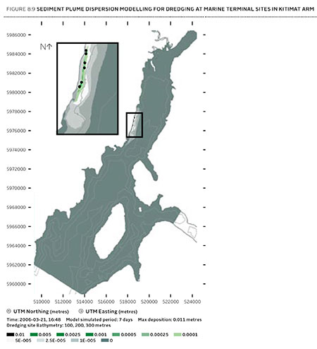
It appears from the report that Enbridge plans to simply allow sediment from the blasting and dredging to float down Douglas Channel, dispersed by the currents and the outflow from the Kitimat River.
Northern Gateway said that dredging and blasting for marine terminal construction would result in a sediment plume that would extend over an area of 70,000 square metres for the duration of blasting activities.
Approximately 400 square metres of the assessed area of the marine terminal is expected to receive more than 1 centimetre of sediment deposition due to dredging. Outside of this area, typical sediment deposition levels alongshore where sediment is widely dispersed (a band approximately 4 kilometres long and 400 metres wide) are very low; in the range of 0.001 to 0.1 centimetres. Dredging and blasting activities are expected to occur over a period of approximately 18 weeks.
Northern Gateway expected most of the sediment plume created by construction activities to be minor in relation to natural background levels.
Northern Gateway would use bubble curtains to reduce pressure and acoustic effects of blasting, and silt curtains to reduce the effect of sedimentation from dredging. It said that bubble curtains are used extensively for other activities, such as pile driving, to reduce the effect of high pressure pulses that can cause injury to fish.
It added that bubble curtains have been tested extensively with blasts, and literature shows they are effective.
Northern Gateway said that physical effects from suspended sediment on marine fish and invertebrates could include abrasion and clogging of filtration mechanisms, which can interfere with ingestion and respiration. In extreme cases, effects could include smothering, burial, and mortality to fish and invertebrates. Direct chemical-related effects of suspended sediment on organisms, including reduced growth and survival, can also occur as a result of the uptake of contaminants
re-suspended by project construction activities, such as dredging and blasting, and as a result ofstorm events, tides, and currents.
The Haisla Nation and Raincoast Conservation objected to Northern Gateway’s figures, noting
Northern Gateway’s sediment and circulation model and its evidence related to contaminated sediment re-suspension at the terminal site. Both parties said that the sediment model was applied for the spring, when the increase in total suspended solids would be negligible compared to background values. In the event of delays, blasting and dredging would likely occur at other times of the year when effects would likely be higher, and these scenarios were not modelled.
The panel’s assessment of the area to be blasted found few species:
Species diversity within Kitimat Arm’s rocky intertidal community is generally low. Barnacles, mussels, periwinkles, and limpets can be found on rocky substrate. Sea urchins, moon snails, sea anemones, sea stars, and sea cucumbers are in shallow subtidal areas. Sandy areas are inhabited by commercially-harvested bivalves such as butter clams and cockles.
Northern Gateway told the JRP that it would “offset” any damage to Douglas Channel caused by the blasting and dredging
Northern Gateway said that construction, operations, and decommissioning of the marine terminal would result in both permanent and temporary alteration of marine fish habitat. Dredging and blasting, and installing physical structures in the water column for the marine terminal would permanently alter marine fish habitat. Based on the current terminal design, in-water site preparation would result in the physical alteration of approximately 1.6 hectares of subtidal marine habitat and 0.38 hectares of intertidal marine habitat. Northern Gateway expected approximately 353 square metres of subtidal marine habitat and 29 square metres of intertidal habitat to be permanently lost.This habitat would be compensated for by marine habitat offsets.
The project’s in-water vertical structures that would support the mooring and berthing structures could create new habitat, offsetting potential adverse effects. The structures may act as artificial reefs, providing marine fish habitat, food, and protection from predation. Although organisms currently inhabiting the work area would be killed, the exposed bedrock would be available for colonization as soon as the physical works are completed.
In its finding on marine sediment, the panel, as it does throughout the ruling, believes that the disruption to the environment caused by previous and ongoing human activity, means that the Northern Gateway Kitimat terminal won’t make that much difference.
Sediment quality in the marine environment is important because sediment provides habitat for benthic aquatic organisms. Northern Gateway’s baseline data for the area immediately surrounding the marine terminal indicated some contamination of water, sediments, and benthic organisms from previous industrial activity. Industrial activities in the Kitimat area have released contaminants through air emissions and effluent discharges since the 1960s. Sources of contaminants to Kitimat Arm
include effluent from a municipal wastewater treatment plant, the Alcan smelter, Methanex Corporation’s methanol plant, and the Eurocan pulpmill, as well as storm water runoff from these operations and the municipality.
Area is largely controlled by natural outflow from the Kitimat River with suspended sediment levels being highest during peak river runoff (May to July, and October) and lowest during winter. Storm events, tides, and currents can also suspend sediments. Levels of total suspended solids fluctuate seasonally and in response to climatic variations, but are generally highest during the summer.
Commercial and recreational vessels currently operating in the area may increase suspended solids by creating water turbulence that disturbs sediments. Given the current sediment contamination levels and the limited area over which sedimentation from construction activities would be expected to disperse, the Panel finds that the risk posed by disturbed contaminated sediment is low. Northern Gateway has committed to monitoring during construction to verify the predicted effects on sediment and water quality for both contaminants and total suspended solids..
The dredging and blasting section of the Joint Review Report is small when compared to the much more extensive sections on pipeline construction and tanker traffic, and the possible effects of a catastrophic oil spill.
Although minor, the marine sediment section exposes the question that was never asked, given the disruptions from years of log dumping at Clio Bay and Minette Bay and the decades of developments at the mouth of the Kitimat River, and future development from LNG, when do cumulative effects begin to overwhelm? How much is enough? How much is too much? If every project continues to be viewed in isolation, what will be left when every project is up and running?
Special report: Clio Bay cleanup: Controversial, complicated and costly
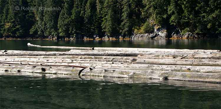
Log booming operations at Clio Bay, August 21, 2013. (Robin Rowland/Northwest Coast Energy News)
Chevron, the company operating the KM LNG project at Bish Cove and the Haisla Nation have proposed that marine clay from the Bish Cove construction site be used to cap more than 10,000 sunken and rotting logs in Clio Bay. Haisla Chief Counsellor Ellis Ross says he hopes that using clay to cover the logs will help remediate the environmentally degrading sections of the Bay. The proposal has brought heated controversy over the plan, both among residents of Kitimat and some members of the Haisla Nation, who say that Clio Bay is full of life and that the capping will cause irreparable damage.
An investigation by Northwest Coast Energy News shows that capping thousands of sunken logs is a lot more complicated and possibly costly than anyone has considered. It is also clear that many of the comments both supporting and opposing the Clio Bay project are based on guesses rather than the extensive scientific literature available on the subject.
Northwest Coast Energy News findings include:
In 1997, the Department of Fisheries and Oceans surveyed sunken log sites in Douglas Channel. The results, published in 2000, identified 52 sites just on Douglas Channel and the Gardner Canal that had various levels of enviromental degradation due to sunken logs. Clio Bay was not the list. The DFO scientists recomended followup studies that never happened.
Scientific studies show that degradation from sunken logs can vary greatly, even within one body of water, due to depth, currents, number of logs, and other factors. So one part of a bay can be vibrant and another part environmentally degraded due to low levels of dissolved oxygen and decaying organic material.
If KM LNG wasn’t paying for the remediation of Clio Bay, it could be very expensive. Capping sunken logs at a cove near Ketchikan, Alaska, that is the same size and shape as Clio Bay cost the US and Alaska governments and the companies involved $2,563,506 in 2000 US dollars. The total cost of the cleanup of the site which was also contaminated with pulp mill effluent was $3,964,000. The estimated cost of capping the logs in the Alaska project was $110 per cubic yard.
The Alaska project shows that a remediation project means while most of the logs in a bay or cove can be capped, in some parts of a water body, depending on currents, contamination and planned future use, the logs have to be removed and the area dredged.
Agencies such as the State of Alaska, the US Environmental Protection Agency and the US Army Corps of Engineers all recommend using “clean sand” for capping operations. Although “clay balls” have been used for capping in some cases, the US officials contacted say they had no record of large amounts of marine clay ever being used for capping. They also noted that every log capping project they were aware of happened in sites that had other forms of contamination such as pulp mill effluent.
Chevron only recently retained the environmental consulting firm Stantec to study Clio Bay. The Department of Fisheries and Oceans has told District of Kitimat Council it recently completed mapping of the seafloor at Clio Bay. The Alaska project was preceded by five years of monitoring and studies before capping and cleanup began.
A letter from Fisheries and Oceans to the District of Kitimat says that Clio Bay has been mapped and the department is planning to monitor any capping operations. However, it appears from the Department of Fisheries and Oceans website that the department has no current policies on remediation since the Conservative government passed two omnibus which weakened the country’s environmental laws. According to the website, new remediation policies are now being drafted. That means that although DFO will be monitoring the Clio Bay operation, it is uncertain what standards DFO will be using to supervise whatever happens in Clio Bay.
Northwest Coast Energy News is continuing its investigation of the sunken logs problem. Expect more stories in the days to come.
Special report: Clio Bay cleanup: Controversial, complicated and costly
Floating logs at Clio Bay, September 14, 2013. (Robin Rowland/Northwest Coast Energy News)
The forest industry has been operating on the Pacific coast from Oregon to Alaska for more than a century. Over that time, it is likely that millions of logs from booms and other operations have sunk to the bottom of bays, cove, estuaries and inlets along the coast.
During that century, scientists in both Canada and the United States have been studying the effects of the those sunken logs on the sea bottom. It is only in recent years that the cumulative effect of all those logs has become an environmental concern.
As well as logs on the sea bottom, ranging, depending on location, from a couple of hundred to the tens of thousands of logs, there are wood chips, wood fibre and discarded log parts and bark. Often metal cables, bolts, ropes, and other manufactured material either dropped accidentally or deliberately discarded are also found among the old logs, further contaminating the seabed. Compounding the problem of the sea bottom is organic material that would occur naturally on the seabed, including tree trunks, roots, branches, conifer needles, deciduous leaves and other material from terrestrial plants.
Anyone who sails Douglas Channel after a storm can see with all the floating tree trunks in the Channe. That means that storms and spring run off ads debris to the natural pile up of old logs and debris. At logging sites, this natural material, brought in by creeks and rivers, piles up on the already sunken logs.
Over the years, depending on the salinity, teredos, more popularly known as ship worms eat the wood, often leaving a tube of bark that eventually collapses. The rotting wood, bark and other material is often, depending on conditions, pounded into fragments by the action of waves, currents and outflow from rivers. Some species of teredo can live in brackish water, but since teredos are not a fresh water species, that means that logs in fresh or mostly fresh water last longer.
A DFO report on sunken log sites on Douglas Channel, published in 2000, noted:
very few comprehensive, quantitative field studies describing the effects of wood and bark have been published and those that did focused on log handling and storage sites which handled high volumes of more than one million cubic metres.
The DFO report said that thick bark and wood debris deposits resulting from log handling can cause substantial, long-term negative impacts to benthic (sea bottom) ecosystems. Under the worst conditions, the cumulative debris can deprive an area of oxygen and, according to DFO, “virtually eliminate aerobic” sea bottom animal life.
The report noted that studies had shown that “negative biological impacts were localized,” but added that “the cumulative effect of several hundred sites located on the B.C. coast is currently unknown.”
Studying the problem has been a low priority for DFO and other agencies and that meant a limited budget and few studies. Other problems is that, according to the DFO, parts of BC fjords are steep and “much of the likely impacted habitat is beyond diver range.” There is also pressure to study the effect on “economically or socially important species.” Although the use of remotely operated vehicles has increased since the 2000 report, using an ROV can also be a budget buster for a low priority project.
As the ready timber supply in British Columbia particularly old growth forest declined in the last part of the twentieth century, the DFO report says “forest companies have harvested areas where access is more difficult and cut-blocks are smaller.” That meant many smaller dump sites were developed that were used for only one to five years. Plans for log handling at the time, DFO said, were evolving to ensure ensure that fisheries resources and overall fish production capability were not adversely affected by development of log handling facilities and planning was focused on ensuring that sites for log handling facilities did “not have sensitive fish habitats or fisheries resources (such as eel grass beds or shellfish resources) which may be affected by the log handling,”
One of the reasons for the disagreements over Clio Bay is that while some people call it “dead” saying there are no halibut and fewer cod, others say that Clio Bay is very much alive, pointing out that it is easy to catch crab and rock cod.
The studies that have looked at life on the bottom of log dumps sites have shown that it can be highly variable even within one bay or cove, with many factors creating small local ecosystems, including depth, nature of the sea bottom, for example sand, mud, clay or a mixture, whether or not the sea bottom sediment is “enriched,” the flow of currents, fresh water flow into the site, the percentage of wood on the bottom, the percentage of bark on the bottom, whether the wood and/or bark debris is “continuous’ or “discontinuous,” whether or not the seabed is contaminated as was the case with the cleanup of pulp mill sites at Ward Cove and Sitka, Alaska.
Ward Cove had been so polluted for decades by pulp mill effluent that it was eligible for US Superfund clean up funding and was estimated to hold 16,000 sunken logs. At the same time, an EPA report on Ward Cove noted that at the point Ward Creek emptied into Ward Cove was “a popular sport fishing location during salmon season, including commercially guided fishing. Some sport fishing and personal-use crab pot fishing has taken place in the past and may continue in the waters of the cove.” At the same time of the cleanup, the EPA identified that the degradation of Ward Cove put at risk eight species of salmon, 75 “non-salmonid esturine and marine fish species and benthic invertebrate fauna.” (The EPA says Ward Cove is recovering after the reclamation and fishing is continuing)
In other words, those say Clio Bay is in danger and those who say Clio Bay is a rich source of life are likely both right.
For example, while Chris Picard’s (then with the University of Victoria, now with the Gitga’at First Nation) study of Clio Bay said: “Dungeness crabs were observed five times more often in the unimpacted Eagle Bay than in Clio Bay,” and tied that to log dumping and low oxygen.
Picard’s study noted that both Dungeness crabs and sunflower seastars, while more abundant in Eagle Bay, in Clio Bay “both species were several-fold less abundant in wood-dominated habitats in Clio Bay than in non-wood habitats in that bay.”
Several people have pointed out that since Clio Bay is one of the closest crabbing spots to both Kitimat and Kitamaat Village, while Eagle Bay is further down Douglas Channel, overfishing at Clio may be a factor in the reported species decline.
The DFO study noted
The dumping of logs into water down skids can result in the generation of a considerable amount of bark and wood debris. The abrasive action of boom boats and waves during the sorting and storage of bundles can also generate quantities of wood debris. Bark and wood lost during dumping often forms thick, continuous, anoxic fibre mats extended from the base of the dump skids. The debris mat tends to dissipate with distance from the entry point; however, wood debris can often be observed substantial.” distances from the dump skids as seen at all four of the sites sampled. Debris deposits can also be generated as logs resting on the sea floor decay. Wood boring organisms (e.g., Toredo) quickly reduce the wood fibre content of logs, but the bark of some species (e.g., western red cedar (Thuja plicata) which has a high lignin content) is left relatively untouched. The amount of wood debris generated during handling and storage can be different depending on tree species, tidal levels, and dumping methods. Debris accumulation, distribution, and the resulting biological impacts are affected by physical factors including depth, sea floor slope, dump site aspect, water currents, and wind or wave exposure.
One of the main problems with log dumping is that it has the potential to deplete vital oxygen, especially at deeper levels. Seasonal variations can mean that, even if there are thousands of logs at the bottom, the levels of dissolved oxygen can vary. Years of studies at the cleanup site at Ward Cove, Alaska showed how the oxygen levels can vary by season. In Minette Bay, near Kitimat, a DFO study showed that the Minette is somewhat stagnant and therefore has naturally occurring low oxygen levels, but also that the low levels usually last from May to November and are worst in July.
The DFO study went on to say that oxygen poor thick anoxic bark or wood fibre deposits are likely to cause damage to bottom dwelling species, although in the short term, logs may not cause any impacts. It says that some studies have indicated that large pieces of wood debris can, for a time, increase diversity by providing suitable base for some filter feeders as well as food and cover for epifauna and wood boring organisms. Several species not normally found in sand-bed have occasionally been found in log and rock debris.
(Studies have shown that salmon the ability to detect low oxygen areas and avoid them and some active invertebrate species can migrate away from a low oxygen area.)
In the long term, logs do decay and the wood and bark left behind can contribute to the wood debris accumulation. One study cited by the DFO survey of Douglas Channel found found that crabs avoided bark deposits when given a choice but when they were forced to live among bark deposits, they were had fewer offspring, had lower feeding rates, and had a decreased survivorship.
One theory is that the decaying organic material produces hydrogen sulphide in combination with ammonia and other unmeasured toxicants. One study of Dungeness crabs, living at a log dump in southeast Alaska with elevated hydrogen sulphide and ammonia concentrations in the bark debris, shows the colony had less than half as many reproducing females as a control population.
The EPA and Alaska reports from Ward Cove show that sand capping does help restore the seabed environment.
[rps-include post=5057]
Seaspan ULC, the large BC-based marine transportation and shipbuilding company is keeping its on eye on future opportunities in Kitimat and along Douglas Channel, chief executive officer Jonathan Whitworth said Tuesday.
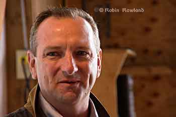
Jonathan Whitworth, CEO of Seaspan ULC, at the RCM SAR 63 boathouse. (Robin Rowland)
Whitworth was in Kitimat to meet members of the Royal Canadian Marine Search and Rescue Unit 63, which operates from the Nechako Dock.
He also met with members of the Haisla Nation while he was in town.
Kitimat SAR 63 is one of six stations which will receive $8,500 a year for three years, to help cover operating expenses, from the Dennis and Phyllis Washington Foundation, based in Missoula, MT. Seaspan is part of the Washington group of companies, that has holdings on the west coast of Canada and the United States, owned principally by Dennis Washington.
At the moment, Whitworth said, Seaspan operates the HaiSea in partnership with the Haisla Nation. “It’s a boat that you will see up and down the Channel, she does a lot of work for RTA as well as some of the others, mainly from the construction and the up and coming constrution from the new projects. We take a lot of time and effor to make sure our equipment looks good as well as operates well. That’s the kind of pride our crew puts in the vessels and the company supports.” he said. Seaspan barges are also used for the construction projects currently under way in Kitimat.
Whitworth said that while Douglas Channel is not yet “packed on the water,” shipping will likely increase in the coming years. “There are two big dominoes to fall, the first one is any of these big projects being talked about that are going to increase shipping in the Douglas Channel, be
it Chevron or Shell or the BC LNG project. They need to get approval first, that hasn’t happened yet. We understand it may be within the next six to twelve months before we hear some announcements. When that goes ahead, we can start looking at building new boats, be it escort tugs, or docking vessels, or additional vessels… That will help up us to know the time for when we need to deliver new boats for the Douglas Channel.”
Seaspan has always had a close relationship with the Canadian Coast Guard, Whitworth said and that relationship is even closer now that the Seaspan’s Vancouver Shipyards, was chosen by the federal government for the National Shipbuilding Procurement Strategy for non combat vessels. In February, the federal government announced (pdf) a series of preliminary contracts valued at a total of $15.7 million for the joint support ships, the CCGS John G. Diefenbaker polar icebreaker and the offshore fisheries science vessels.
The Washington Foundation is giving a multi-year donation of $1.1 million to three British Columbia marine and port community charitable organizations. Partnering with Sail and Life Training Society (SALTS), Vancouver Maritime Museum (VMM) and Royal Canadian Marine Search & Rescue (RCM-SAR).
Royal Canadian Marine Search and Rescue received $300,000 over three years. “Half of it $150,000 when to Royal Canadian Marine Search and Rescue Sooke training facility on Vancouver Island, that benefits all of the different stations in BC, they all get a chance to go train and at that training centre,” Whitworth said. “The remaining funds, the $150,000 was spread between six stations that are closely associated with Seaspan, so two in Vancouver harbour, North Vancouver, West Vancouver, two on the Fraser River, one at Delta and one at Richmond, one at Victoria and one right here in Douglas Channel in Kitimat.” The $8,500 covers approximately 35 per cent of the operating costs for Kitimat’s SAR 63 station every year for three years.
The Dennis and Phyllis Washington Foundation’s charitable donations are the organization’s first direct donation of their kind in Canada. Since its inception, the Washington Foundation has donated more than $144 million in the United States to hundreds of organizations that focus on education, health and human services, arts and culture, and community service.
Mike Halligan, Executive Director of the Washington Foundation, says today’s announcementis the start of an exciting inaugural collaboration with Canadian charitable organizations in British Columbia.
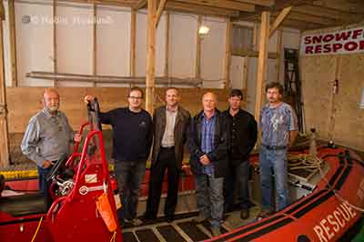
Members of RCM SAR Unit 63, on board “Snowflake Responder” with Seaspan CEO Jonathan Whitworth. (Robin Rowland)
Kitimat’s SAR 63 operates along Douglas Channel and down the Inside Passage as far as Butedale. Training takes place every Wednesday evening at the SAR 63 boathouse at the Nechako Dock. The unit will be recruiting new members in September. Anyone interested can contact training officer Duncan Peacock.
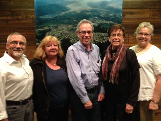
Natural Resources Minister Joe Oliver (centre) meets District of Kitimat Councillors, left to right, Rob Goffinet, Mary Murphy, Mayor Joanne Monaghan and Corinne Scott. (District of Kitimat)
Natural Resources Minister Joe Oliver made a brief visit to the Kitimat area on Tuesday July 23, 2013, meeting Haisla Chief Counsellor Ellis Ross. In the original planning for the visit, Oliver was not scheduled to meet with District of Kitimat Council or other members of the community, snubbing Kitimat in only his second visit to the region since he was appointed minister after the 2011 federal election.
A half hour meeting with available members of the District of Kitimat Council was squeezed in only after intense lobbying from Mayor Joanne Monaghan.
The Natural Resources department public relations staff also chose to ignore (or exclude) local media, with the exception of the Northern Sentinel. Northwest Coast Energy News, Kitimat Daily, CFTK and CRFN were not informed and did not accompany Oliver on his hour long tour of Douglas Channel.
After the meeting, Natural Resources Canada issued a news release saying that he had concluded “a successful visit to Kitimat,” hosted by the Haisla:
Minister Oliver discussed opportunities to increase First Nations’ participation in resource development and received a tour of the Douglas Channel hosted by Chief Councilor Ellis Ross.
“I am privileged to have been invited by the Haisla Nation to gain their perspective, listen to their concerns and discuss our plans for Responsible Resource Development and our initiatives to strengthen environmental protection,” said Minister Oliver. “Resource development presents a tremendous opportunity for First Nations groups like the Haisla. Our government has also been clear that development will only proceed if it is safe for the environment…”
“Responsible resource development has the potential to create significant new opportunities for Aboriginal peoples across Canada,” said Minister Oliver. “The Government will make every effort to ensure that…
Aboriginal peoples in Canada have the opportunity to share the benefits of energy resource development in the years ahead, while ensuring that projects are developed in a manner that has the highest regard for safety and the environment.”
“The safe and responsible diversification of our energy markets is a priority for the Government of Canada,” said Minister Oliver. “Our energy industry must remain competitive to ensure communities across Canada continue to benefit from our natural resource wealth.”
The Northern Sentinel reported that Oliver mainly concentrated on liquified natural gas development and tried to avoid questions about the Enbridge Northern Gateway project. Oliver repeated the federal government’s position on safety outlining the programs announced last march to expand pipeline expansion and increase penalties for safety violations.
On LNG, Oliver told the Sentinel, “These are decisions made by the private sector, it’s not us telling us don’t do this project…they’re going to figure that out themselves,” he said.
On the Enbridge Northern Gateway Pipelines Project, Oliver told the Sentinel, “We have a very strong interest in seeing the markets diversify, and that includes moving oil to Asia,” he said. “However, we’re not going to stomp over the regulatory process. It’s subject to regulatory review, the joint review panel will be coming to its conclusion this December. We’re waiting for what they have to say…I know people have a view of what our opinion is but we don’t offer an opinion before we hear from the regulator.”
He added that once the review is done, “At that point we’ll know more because they will have a done a comprehensive, scientific audit.”
Councillor Mary Murphy told Northwest Coast Energy News that she was told by a Haisla friend early Tuesday morning that Oliver was coming to visit Kitamaat Village and immediately informed Mayor Joanne Monaghan.
Monaghan said, “I called his office in Ottawa and said I wanted a meeting as well seeing he was here. After an all day back and forth until three o’clock he said he would come at four for half an hour.”
Councillor Corinne Scott said. “As none of us were aware of the Minister being in Kitimat, we scrambled to have Mary, Rob, the Mayor and I available to meet with him, along with [DOK Chief Admnistrative Officer] Ron [Poole] and [Economic Development Officer] Rose Klukas.”
Councillors Mario Feldhoff, Phil Germuth and Edward Empinado were unable to attend because they working at the time and could not get away with such short notice. Sources tell Northwest Coast Energy News that even pro-development members of the local business community were not informed about Oliver’s visit.
Murphy described the meeting “as very beneficial to us.” A couple of other sources, familiar with accounts of the meeting, however, both told Northwest Coast Energy News there was barely enough time after formalities to ask questions of the minister before he dashed out the door for the airport.
Five days after the announcement that the private port of Kitimat will become a public port under federal jurisdiction, Transport Canada is now promising to consult District of Kitimat officials as the Douglas Channel waterfront transitions to a public port.
Both Kitimat Mayor Joanne Monaghan and Economic Development Officer Rose Klukas, after numerous calls and attempts over the past few days, finally spoke to different Transport Canada officials Friday.
According to the mayor, both were told that Kitimat will not become a public port for at least one year because the change from a private port to a public port requires a change in legislation. (Something Transport Canada may only just be realizing since Bill C-57, introduced Monday to cover all the changes for what the Harper government calls a “world-class” tanker policy makes no mention of Kitimat).
Transport Canada is now promising “extensive public and stakeholder consultation will occur before the legislation is changed,” the mayor was told.
On this Mayor Monaghan commented, “It seems to me that now they want to do consultation….sort of like closing the barn door after all of the cows got out!”
Transport Canada says that beause there are no federal lands in the Kitimat harbour, the amending legislation will only cover navigable waters in Kitimat.
Transport Canada will appoint a harbour master and the cost of that office will be “paid by offsetting fees charged to ships coming into the harbour.”
But it looks like the fees charged to incoming ships by the federal government could be causing a headache for Rio Tinto Alcan. Claudine Gagnon, an RTA spokesperson based in Shawnigan, Quebec, told Radio Canada, the French language network of the CBC, that the company is trying to assess the impact of the announcement on its operations in Kitimat. Among other things, the change in the port’s status could result in higher transportation costs for the company.
At this point, Transport Canada officials told the District is unlikely that there will be Port Authority in Kitimat like the one in Prince Rupert.
Cullen surprised
Asked about the port announcement during a post budget news conference on Thursday, Skeena Bulkley Valley MP and NDP House Leader Nathan Cullen said, “I’m as surprised as everybody in Kitimat is. I’ve been phoning around to local leaders to find out if anyone had been consulted or spoken to about this. And it’s a shock for everyone including people from Alcan.
“This doesn’t make any sense at all. The conversation around a public port is a good one and one we need to have and we’re open to the idea, but what a terrible start to the process, when a minister flies in from Ottawa, announces something, doesn’t tell any of the local government about it and then expects everyone to pop the champagne corks. You want to get this thing right. You want to make sure the public interests are met.
“There’s a real arrogant feeling, when a minister flies in from Toronto and says this is how it’s going to be and there’s no need to talk to anyone in the region about it.
Cullen was also asked about the provisions in the safe tankers announcement on Monday by Transport Minister Denis Lebel and Natural Resources Minister Joe Oliver that the federal government appears to be taking over responsibility for navigation aids on the British Columbia coast, something that until now, Enbridge Northern Gateway has said they will pay for.
“Suddenly taking costs away from a multi-billion dollar oil company, seems to be what this Conservative Canadian government wants to do. It’s so wrong, I can’t describe it any better than that,”Cullen said, “that we’re supposed to be picking up the tab for Enbridge’s project, while all the while running huge deficits and not getting the training support and cuts to health care programs that continue.”