SFU study says spill hazards for Kitimat from tankers and pipelines much greater than Enbridge estimate

A study by two scholars at Simon Fraser University says that the Enbridge Northern Gateway project is much more hazardous to Kitimat harbour, Douglas Channel and the BC Coast than Enbridge has told the Joint Review Panel.

The study by Dr. Thomas Gunton, director of the School of Resource and Environmental Management at SFU and Phd student Sean Broadbent, released Thursday May 2, 2013 says there are major methodological flaws in the way Enbridge has analyzed the risk of a potential oil spill from the bitumen and condensate tankers that would be loaded (bitumen) or unloaded (condensate) at the proposed terminal at Kitimat.

Enbridge Northern Gateway responded a few hours after the release of the SFU study with a statement of its own attacking the methedology used by the two SFU scholars and also calling into question their motivation since Gunton has worked for Coastal First Nations on their concerns about the tanker traffic.

Combination of events

One crucial factor stands out from the Gunton and Broadbent study (and one which should be confirmed by independent analysis). The two say that Enbridge, in its risk and safety studies for the Northern Gateway project and the associated tanker traffic, consistently failed to consider the possibility of a combination of circumstances that could lead to either a minor or a major incident.

Up until now, critics of the Northern Gateway project have often acknowledged that Enbridge’s risk analysis is robust but has consistently failed to take into consideration the possibilty of human error.

As most accidents and disasters happen not due to one technical event, or a single human error, the SFU finding that Enbridge hasn’t taken into consideration a series of cascading events is a signficant criticism.

Overall the SFU study says there could be a tanker spill every 10 years, not once in 250 years, as calculated by Enbridge.

It also says there could be 776 oil and condensate spills from pipelines over 50 years, not 25 spills over 50 years as projected by Enbridge. (And the life of the project is estimated at just 30 years, raising the question of why the 50 year figure was chosen)

Enbridge track record

The study also bases its analysis of the possibility of a spill not on Enbridge’s estimates before the Joint Review Panel but on the company’s actual track record of pipeline spllls and incidents and concludes that there could be between one and 16 spills (not necessarily major) each year along the Northern Gateway pipeline.


Findings for Kitimat

Among the key findings for Kitimat from the SFU study are:

  • Enbridge said the possibility of tanker spill was 11.3 to 47.5 per cent over the 30 year life of project. The SFU study says the possibility of a spill within the 30 years is 99.9 per cent.
  • The SFU study says it is likely there will be a small spill at the Kitimat Enbridge terminal every two years.
  • The SFU study estimates that there will be eight tanker transits each week on Douglas Channel if the Northern Gateway project goes ahead and more if it is expanded.  (This, of course, does not include LNG tankers or regular traffic of bulk carriers and tankers for Rio Tinto Alcan)
  • The SFU study says that while Endridge did study maneuverability of tankers, it paid little attention to stopping distance required for AfraMax, SuezMax tankers and Very Large Crude Carriers.
  • The SFU study says Enbridge inflated effectiveness of the proposed tethered tugs and maintains the company did not study ports and operations that use tethered tugs now to see how effective tethering is.
  • The SFU says Enbridge’s risk analysis covered just 233 nautical miles of the British Columbia coast, where as it should have covered entire tanker route both to Asia and California, raising the possibility of a tanker disaster outside British Columbia that would be tied to the Kitimat operation.
  • Based on data on tanker traffic in Valdez, Alaska, from 1978 to 2008, the SFU study estimates probability of a 1,000 barrel spill in Douglas Channel at 98.1 per cent and a 10,000 barrel spill at 74.2 per cent over 30 year Gateway life. The Valdez figures account for introduction of double hulls after Exxon Valdez spill in 1989 and notes that spill frequency is much lower since the introduction of double hulled tankers.
  • According to a study by Worley Parsons for Enbridge in 2012, the Kitimat River is the most likely area affected by an unconstrained rupture due to geohazards in the region. According to the Worley Parsons study, geohazards represent the most significant threat to the Northern Gateway pipeline system.

Flawed studies

The SFU scholars list a series of what they say are major methological or analytic flaws in the information that Enbridge has presented to the Joint Review Panel, concluding that “Enbridge significantly understates the risk of of spills from the Northern Gatway.

Enbridge’s spill risk analysis contains 28 major deficiencies. As a result of these deficiencies, Enbridge underestimates the risk of the ENGP by a significant margin.
Some of the key deficiencies include:

  • Failure to present the probabilities of spills over the operating life of the ENGP
  • Failure to evaluate spill risks outside the narrowly defined BC study area
  • Reliance on LRFP data that significantly underreport tanker incidents by between 38 and 96%.
  • Failure to include the expansion capacity shipment volumes in the analysis
  • Failure to provide confidence ranges of the estimates
  • Failure to provide adequate sensitivity analysis
  • Failure to justify the impact of proposed mitigation measures on spill likelihood
  • Potential double counting of mitigation measures
  • Failure to provide an overall estimate of spill likelihood for the entire ENGP
  • Failure to disclose information and data supporting key assumptions that were used to reduce spill risk estimates
  • Failure to use other well accepted risk models such as the US OSRA model


SFU reports that Enbridge provides separate estimates of the likelihood of spills for each of the three major components of the project:

      • tanker operations,
      • terminal operations,
      • the oil and condensate pipelines.

The SFU scholars say Enbridge does not combine the separate estimates to provide an overall estimate of the probability of spills for the entire project and therefore does not provide sufficient information to determine the likelihood of adverse environmental effects……

It notes that “forecasting spill risk is challenging due to the many variables impacting risk and the uncertainties in forecasting future developments affecting risk. To improve the accuracy of risk assessment, international best practices have been developed.”

Part of the problem for Enbridge may be that when the company appeared before the Joint Review Panel it has repeatedly said that will complete studies long after approval (if the project is approved), leaving large gaps in any risk analysis.

The SFU study may have one example of this when it says Enbridge did not complete any sensitivity analysis for condensate spills at Kitimat Terminal or the condensate pipeline.

Enbridge response

Enbridge responded by saying

Our experts have identified a number of omissions, flawed assumptions and modeling errors in the study and have serious concerns with its conclusions:
The spill probability numbers are inflated: The author uses oil throughput volumes that are nearly 40 per cent higher than those applied for in this project which also inflates the number of tanker transits using these inflated volumes
The pipeline failure frequency methodology adopted by Mr. Gunton is flawed, and does not approximate what would be deemed a best practices approach to the scientific risk analysis of a modern pipeline system
Mr. Gunton based his failure frequency analysis on a small subset of historical failure incident data. Why would he limit the source of his data to two pipelines with incidents not reflective of the industry experience and not reflective of the new technology proposed for Northern Gateway?
The study results are not borne out by real world tanker spill statistics. Based on Mr. Gunton’s estimates we should expect 21 to 77 large tanker spills every year worldwide while in reality after 2000 it has been below 3 per year and in 2012 there were zero.

Most of Enbridge’s rebuttal is a personal attack on Gunton, noting

We are very concerned about the misleading report released by Mr. Gunton, who was a witness for the Coastal First Nations organization during the Northern Gateway Joint Review Panel process.
Mr. Gunton should have made his study available to the JRP process, the most thorough review of a pipeline that’s ever taken place in Canada. All of Northern Gateway’s conclusions have been subject to peer review, information requests and questioning by intervenors and the Joint Review Panel.

In response, Gunton told the Globe and Mail “the report took over a year to complete and it was not ready in time to be submitted as evidence before the federal Joint Review Panel which is now examining the proposed pipeline.”

Enbridge’s statement also ignores the fact under the arcane rules of evidence, any study such as  the  one from Simon Fraser had to be submitted to the JRP early in the process, while evidence was still being submitted.

The recent ruling by the JRP for closing arguments also precludes anyone using material that was not entered into evidence during the actual hearings.

That means that the SFU study will be ignored in the final round of the Joint Review Panel, which can only increase the disillusionment and distrust of the process that is already common throughout northwest British Columbia.
Enbridge files massive river oil spill study with the Joint Review Panel

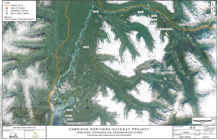
Kitimat River map from Enbridge study
A Google Earth satellite map of the Kitimat River used as part of Enbridge Northern Gateway’s oil spill modelling study.

Enbridge Northern Gateway today filed a massive 11-volume study with the Joint Review Panel outlining possible scenarios for oil spills along the route including the Kitimat and Morice Rivers in British Columbia.

The study, carried out by three consulting firms, Stantec Consuting and AMEC Environmental & Infrastructure both of Calgary and RPS ASA of Rhode Island, is called “Ecological and Human Health Assessment for Pipeline spills.”

Overall the models created by study appear to be extremely optimistic, especially in light of recent events, such as the damning report on by the US
National Transportation Safety Board and the finding of violations by the US Pipeline and Hazardous Material Safety Administration with Enbridge operations during the 2010 Marshall, Michigan, spill and subsequent cleanup difficulties encountered by Enbridge.

The executive summary of the report begins by saying

This document presents conservatively developed assessments of the acute and chronic risk to ecological and human receptors in the unlikely event of a full bore pipeline break on the proposed Enbridge Northern Gateway Pipeline project. Three representative hydrocarbon types (condensate, synthetic oil
and diluted bitumen) were evaluated with releases occurring to four different rivers representing a range of hydrological and geographic characteristics, under both low-flow and high-flow conditions. The analysis indicates that that the potential environmental effects on ecological and human health from each hydrocarbon release scenario could be adverse and may be significant. However, the probability of the releases as considered in the assessment (i.e., full bore rupture, with no containment or oil recovery) is low, with return periods for high consequence watercourses ranging from 2,200 to 24,000 years. Therefore, the significant adverse environmental effects as described in this report are not likely to occur.

So the study says that it is “conservative” that means optimistic, that a full bore pipelink break with no containment or recovery is “an unlikely event” and would probably occur every 2,200 and 24,000 years. Not bad for a pipeline project that is supposed to be operational for just 50 years.

The summary does caution:

The analysis has also shown that the outcomes are highly variable and are subject to a great many factors including the location of the spill, whether the hydrocarbons are released to land or directly to a watercourse, the size of the watercourse, slope and flow volumes, river bed substrate, the amount of suspended particulate in the water, environmental conditions (such as the time of year, temperature and wind speeds, precipitation, etc.), the types of shoreline soils and vegetative cover and most significantly, the type and volume of hydrocarbon released.

The highly technical study is Enbridge’s official response to those intervenors who have “requested additional ecological and human health risk assessment studies pertaining to pipeline spills” and a request from the Joint Review Panle for more information about “the long term effects of pipeline oil spills on aquatic organisms (including the sensitivity of the early life stages of the various salmon species), wildlife, and human health.”

The report presents modelling on the release of three hydrocarbons, diluted bitumen, synthetic oil and condensate at four river locations along the pipeline route for their potential ecological and human health effects, under two flow regimes (i.e., high and low flow), broadly representing summer and winter conditions.

Modelling was done for four areas:

• Chickadee Creek: a low gradient interior river tributary discharging to a large river system
located up-gradient from a populated centre within the Southern Alberta Uplands region
• Crooked River: a low gradient interior river with wetlands, entering a lake system within
the Interior Plateau Region of British Columbia
• Morice River: a high gradient river system along the western boundary of the Interior
Plateau Region of British Columbia
• Kitimat River near Hunter Creek: a high gradient coastal tributary discharging to a large
watercourse with sensitive fisheries resources, downstream human occupation, and discharging to the Kitimat River estuary

In one way, the study also appears to be a partial victory for the Kitimat group Douglas Channel Watch because the model for the Kitimat River is based on a spill at Hunter Creek, which has been the subject of extensive work by the environmental group, but the consulting study is markedly optimistic compared to the scenario painted by Douglas Channel Watch in its presentations to District of Kitimat council.

The study describes the Kitimat River:

The hypothetical release location near Hunter Creek is southwest of Mount Nimbus, in the upper Kitimat  River watershed, and flows into Kitimat River, then Kitimat Arm, approximately 65 km downstream. The area is in a remote location and maintains high wildlife and fisheries values. The pipeline crossing near Hunter Creek is expected to be a horizontal direction drilling (HDD) crossing. The release scenario
assumes a discharge directly into Kitimat River…

The streambed and banks are composed of coarse gravel, cobbles and boulders. Shoreline vegetation (scattered grasses and shrubs) occurs in the channel along the tops of bars. Vegetation is scattered on the channel banks below the seasonal high water mark and more developed (i.e., grasses, shrubs and trees) bove the seasonal high water mark.

Wildlife and fish values for the Kitimat River are high: it is important for salmon stocks, which also provide important forage for grizzly bears, bald eagles and osprey on the central coast. The Kitimat River estuary, at the north end of Kitimat Arm, also provides year-round habitat for some waterbirds and seasonal habitat for staging waterfowl.

There is considerable recreational fishing, both by local people and through fishing guides, on Kitimat River, its estuary and in Kitimat Arm. There is also likely to be a high amount of non-consumptive recreational activity in the area, including wildlife viewing, hiking and camping. The Kitimat River estuary, for example, is well known for waterbird viewing.

While no fish were captured at this location during the habitat survey, salmonoid fry and coho salmon were observed downstream. Previously recorded fish species in the area include chinook, coho and chum salmon, rainbow trout, Dolly Varden, and steelhead trout.

However, the next paragraph appears to show that a full bore rupture on the Kitimat River would have widespread consequences because it would cover a vast area of First Nations traditional territory, saying

Aboriginal groups with traditional territories within the vicinity of the Kitimat River hypothetical spill scenario site include the Haisla Nation, Kitselas First Nation, Kitsumkalum First Nation, Lax-Kw’alaams First Nation and Metlakatla First Nation.

It also acknowledges:

Oral testimony provided by Gitga’at First Nation and Gitxaala Nation was also reviewed in relation to this hypothetical spill scenario, although the traditional territories of these nations are well-removed from the hypothetical spill site.

The report then goes on to list “the continued importance of traditional resources” for the aboriginal people of northwestern BC.

especially marine resources. People hunt, fish, trap and gather foods and plants throughout the area and traditional foods are central to feasting and ceremonial systems. Food is often distributed to Elders or others in the community. Written evidence and oral testimony reported that Coho, sockeye, pink, and spring salmon remain staples for community members. Halibut, eulachon, herring and herring roe,
various species of cod, shellfish, seaweed, and other marine life are also regularly harvested and consumed, as are terrestrial resources, including moose, deer, beaver, muskrat and marten. Eulachon remains an important trade item. Written evidence provides some information on seasonality of use and modes of preparation. Seaweed is dried, packed and bundled and preserved for later use. Each species of
salmon has its own season and salmon and other fish are prepared by drying, smoking, freezing or canning. Salmon are highly valued and often distributed throughout the community…

Some areas used traditionally are not depicted geographically. Upper Kitimat River from the Wedeene River to the headwaters has long been used for trapping, hunting, fishing and gathering of various foods. Fishing, hunting and gathering activities take place along the lower Kitimat River and its tributaries. Marine resources are collected in Kitimat Arm, Douglas Channel, and Gardner Canal. Old village and
harvesting sites are located along the rivers and ocean channels in this vicinity.

Intertidal areas are important and highly sensitive harvesting sites that support a diversity of species. Many intertidal sites are already over harvested and are therefore vulnerable. Conservation of abalone has been undertaken to help the species recover. Some concern was expressed in oral testimony regarding the
potential for archaeological sites and the lack of site inventory in the area. Oral testimony made reference to the Queen of the North sinking and the potential for a similar accident to result in human health and environmental effects.

A spill at Hunter Creek

The model says that all three types of floating oil in Kitimat River under high-flow conditions would reach approximately 40 kilometres downstream from Hunter Creek while low-flow conditions showed variation.

Under what the study calls low flow conditions, most condensate would evaporate. The bitumen would cause “heavy shore-oiling” for the first 10 kilometres, with some oiling up to 40 kilometres downstream.

The most sedimentation would occur for synthetic oil, and the least for condensate. Synthetic oil under both flow conditions would have the largest amounts deposited to the sediments. This is because of the low viscosity of synthetic oil, which allows it to be readily entrained into the water where it may combine with suspended sediments and subsequently settle. Synthetic oil under high-flow conditions would result in the most entrained oil and so the most extensive deposition to the sediment. Diluted bitumen, for both flow conditions, would result in the most deposited on shorelines, with the remainder (except that which evaporated or degraded) depositing to the sediments.
The condensate also would also have significant entrainment, but higher winds prevailing in under low flow conditions would enhance evaporation and rapidly lower concentrations in the water as compared to high-flow conditions. In all scenarios, a large amount of entrained oil and high concentrations of dissolved aromatics would move down the entire stretch of Kitimat River and into Kitimat River estuary.

Long term scenario

The modelling appears to be extremely optimistic when it reaches four to six weeks after the pipeline breach, especially in light of the continued cleanup efforts in Michigan, estimating that the “fast-flowing” nature of the Kitimat River would disipate all the different forms of hydrocarbon in the study saying

 a fast-flowing coastal river like Kitimat River, with gravel or cobble bottom would be affected by a large volume of crude oil released in a short period of time.

Oiling of shoreline soils is heavy in the reaches between the release point and 10 km downstream, becoming lighter to negligible beyond 10 km. Deposition of hydrocarbons to river sediment is greatest for the synthetic oil and diluted bitumen (high flow) scenarios extending up to 40 kilometres downriver, with predicted hydrocarbon concentrations in sediment approaching 1,000 mg/kg dry weight. Deposition of hydrocarbons to river sediment is considerably lighter for the diluted bitumen (low flow) and condensate scenarios. In these scenarios, oiling of river sediment is negligible….

It says that within four weeks of the end of the acute phase of the spill scenarios, concentrations in river sediments and river water would decline becoming quite low at the end of two years.

As for the affects on plants and invertebrates:

Oiling of shorelines would be extensive, particularly at assessment locations within 10 kilometres of the pipeline break location, under both the high and low flow scenarios, for synthetic oil and condensate. High loadings occur as far as 25 kilometres downstream, again asusming that damage would begin to disipate after four weeks declining over the next one to two years. Predicted effects are generally less severe for the diluted bitumen spill scenarios, due to lower expected loading of oil onto shorelines. Low to negligible shoreline oiling would occur for Kitimat River under most of the scenarios at the 40 kilometres assessment location and points downstream. Based on this assessment, very little oiling of shorelines would extend to the estuary and the environmental effects would be minimal.

The study goes on to say that the “model suggests that there would be no significant risk to fish health based upon chronic exposure to petroleum hydrocarbons  for the oil spill scenarios in Kitimat River or the potentially affected areas within the estuary, either at four weeks or one to two years following the hypothetical spill events. Risk to developing fish eggs in Kitimat River and estuary at four weeks and one to two years again indicate no significant risk to developing fish eggs in spawning gravels.”

It also claims that “chronic risks” to wildlife would be minimal, with some elevated risk for “muskrat, belted kingfisher, mallard duck, spotted sandpiper and tree swallow,” if they were exposed to synthetic oil. The muskrat, mallard duck and spotted sandpiper
could be vulnerable to bitumen and diluted bitumen.

It then claims that “no significant effects of chronic exposure (to all hydrocarbons) would occur for grizzly bear, mink, moose, river otter, bald eagle, Canada goose, herring gull or great blue heron for the Kitimat River hydrocarbon spill scenarios.”

Again, it appears from the sutdy that the spotted sandpiper would be most vulnerable to “bulk weathered crude oil exposure” includingcondensate, diluted bitumen and synthetic oil.

For the Kitimat section it concludes:

In the unlikely event of an oil spill, recovery and mitigation as well as the physical
disturbance of habitat along the watercourse would be likely to substantially reduce the exposure of wildlife receptors to hydrocarbons as compared to the scenarios evaluated here.

Link to Volume One of the Enbridge Northern Gateway Report Ecological and Human Health Assessment for Pipeline Spills

Enbridge question on “marine vessel activity” on Douglas Channel gets obvious answer from the Haisla

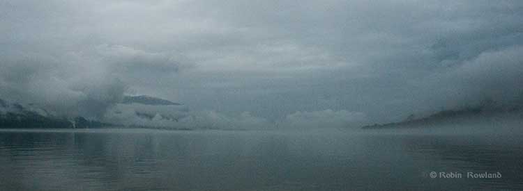
Fog shrouds Kitimat harbour
Fog and low clouds shroud Kitimat harbour on the morning of June 27, 2012. (Robin Rowland/Northwest Coast Energy News)

If there is a major disconnect between the people who live in the Kitimat region and the rest of Canada, it is the question of vessel traffic on the Douglas Channel, with Enbridge spinning that there is already major tanker traffic on the Channel.

This section from the Northern Gateway website, is often quoted by Enbridge supporters, the vast majority of whom live in Alberta, thousands of kilometres away, have never been to Kitimat, but, somehow from Calgary or Fort McMurray,  claim to know more about the Douglas Channel than people who live in Kitimat, including those who have sailed Douglas Channel for decades.

On its website Northern Gateway claims

According to numbers from the Port of Kitimat, not only have vessels carrying industrial products been travelling the channels safely for some 35 years, but so too have ships carrying petroleum products—like the one featured arriving in the Port of Kitimat through the Douglas Channel in the picture above.
In fact, some 1,560 vessels carrying methanol and condensate called on Kitimat port from 1982 to 2009 – that’s over 3,100 transits of vessels dedicated to the transport of petroleum products.
When you add vessel traffic of all industrial activity into Kitimat port, the number jumps to 6,112.
To be clear…the number of ships servicing industry arriving at Kitimat port between 1978 and 2009 is 6,112. That’s 12,224 transits!

So in its questions to the Haisla, Enbridge asked:

c) Please confirm that the Haisla Nation is aware of existing and proposed
marine vessel activity within its Traditional Territory, including:

(i) fuel barges

(ii) cargo/container ships

(iii) commercial fishing vessels

(iv) condensate tankers

(v) liquefied natural gas tankers


Enbridge’s question was an obvious attempt to enhance their spin on vessel traffic on the Douglas Channel, by fishing for an admission that large vessels already ply the Channel, something the residents of the Kitimat, both First Nations and non-aboriginal already know well.

In its response, the Haisla Nation replies:

The Haisla Nation is aware of the existing and proposed marine vessel activity within its Territory, including fuel barges, cargo/container ships, commercial fishing vessels, condensate tankers, and liquefied natural gas tankers.

The Haisla Nation is also aware of the increased cumulative effect of additional marine vessel activity as projects are approved. The presence of this shipping increases the significance of the potential impacts of the project on Haisla Nation aboriginal title and rights, through cumulative impacts.

The Haisla Nation is responsible for some of the vessel traffic within its Territory, with modern forms of transportation having replaced canoes. Until legal developments in the early 2000s which have defined the content of the honour of the Crown with respect resource decisions and potential impacts on First Nations, the Haisla Nation had little say about the projects with associated vessel traffic in its Territory.

While standard petroleum product tankers, many carrying condensate, a natural gas product, have been visiting Kitimat for years, there have. so far, been no supertankers, much less Very Large Crude Carriers. No bitumen carrying tankers have visited Kitimat, a fact always ignored by the region’s critics in Alberta and by Enbridge on its website.

Not only the filing by the Haisla Nation but most of the testimony at the recent public comment hearings in at Kitamaat Village, were about the fear of the growing cumulative effect of greatly increased tanker traffic on the Channel.

Little difference between diluted bitumen and conventional crude affect on pipelines, Alberta review says

Energy Environment

    A study by an Alberta provincial government agency has concluded that diluted bitumen (also known in the industry as “dilbit”) is little different in its effects on pipelines than conventional or ‘non-oil sands derived’ crude oil.

A review of existing studies was conducted by Jenny Been, P.Eng for the provincial agency,  Alberta  Innovates – Technology Futures.  A news release on the website describes Been as a “corrosion specialist.”  The study “concludes that the characteristics of dilbit are not unique and are comparable to conventional crude oils during pipeline flow.”

Link News release and study (pdf) 
Comparison of the Corrosivity of Dilbit and Conventional Crude

Been’s study takes on the contention that dilbit has higher acid, sulfur, and chloride salts and higher concentrations of abrasive solids than conventional crude.  As well, the study looks at the belief that dilbit transmission pipelines operate at higher operating temperatures compared with crude, which would make the dilbit more corrosive. Environmentalists and other critics say  this leads to  a higher failure rate than pipelines carrying  crude.

The study compared the  properties  of  heavy,  medium,  and  light  conventional Alberta crude oils with three dilbit and one dilsynbit (a mixture of conventional gas diluent and synthetic gas) crude.

The review  concludes “that the characteristics of dilbit are not unique and are comparable to conventional crude oils.”

While two of the four dilbit crudes displayed a slightly higher naphthenic acid and sulfur concentration than the conventional Alberta heavy crudes, the review notes that there are conventional crudes on the market that have displayed higher values.  It says while there have been corrosion problems at refineries where the temperature can exceed  200 C, it says “the  much  lower  pipeline transportation temperatures, the compounds are too stable to be corrosive and some may even decrease the corrosion rate.”

The study also says “sediment  levels  of  the  dilbit  crudes  were  comparable  to  or  lower  than  the conventional crudes, except for a dilsynbit crude, which showed more than double the quantity of solids than most other crudes, but was still well below the limit set by regulatory agencies and industry….Erosion corrosion was found to be improbable and erosion, if present, is expected to be gradual and observed by regular mitigation practices.”

The study’s recommendations note that it is a review and “It has to be understood that this was a high-level review and a focused, peer-reviewed study has not been conducted.   The scope of the work did not include interviews with industry, regulators, or colleagues.”

It calls for the industry to create a database that would further study that differences between dilbit oils and conventional crude oils,  including further study of sludge formation and deposition in the pipeline and the links, if any,  “on sludge chemistry to pipeline sludge formation and sludge   corrosivity,   including   the   ability   of   the   sludge   to   support   microbial populations.”

Been says in the study that Enbridge supports an industry working group on pipeline corrosion management  that is  “addressing these issues by correlating sludge corrosivity with a chemical and microbial geochemical characterization of the sludge.   The work is further considering and optimizing monitoring technologies to enable measurement of the effectiveness of mitigation treatments.  It is recommended that this effort will continue to be supported.”
   
While the study is a review of existing knowledge on diluted bitumen and conventional oil in pipelines,  Been’s introductory remarks clearly show a bias in favour of the bitumen sands, saying, before the Keystone XL project approval was delayed by the U.S. State Department, “TransCanada Pipeline’s (TCPL’s) $13 billion Keystone pipeline system will provide a secure and growing supply of Canadian crude oil to the largest refining markets in the Unites States.”

Been also notes

Environmental  groups  opposed  to  the  pipelines  continue  to  find  material  to  fuel  their concerns: the more than 800,000 gallons of oil spilled into the Kalamazoo River in Michigan last year came from the Cold Lake oil sands region, and the Exxon Mobil spill of 42,000 barrels of oil in the Yellowstone River may have contained dilbit.   Protestors against the Keystone pipeline are gathering in demonstrations across North America leading to mass arrests and drawing widespread attention.

The arguments of these environmental groups don’t go unheard with congressmen and other government officials, who have iterated reported statements and concerns.  The United States Department of States (DOS) has spent the last three years in review with the industry, scientific community, and other interest parties (including numerous public meetings), evaluating the purpose and need for the Project (pipeline), alternatives, and the associated potential environmental impacts.   The result was issued on August 26, 2011 in a Final Environmental Impact Statement (FEIS), a comprehensive, detailed volume of work that is available to the public. Public hearings were held and online comments were accepted.

Been notes that as part of the Keystone assessment, the US  Department of Transportation’s  Pipeline and Hazardous Materials Safety Administration (PHMSA) issued 57
Project-specific Special Conditions above and beyond the requirements of the United States pipeline code for  Keystone XL. Been says TransCanada agreed to the incorporation of the 57 conditions and said would result in a pipeline with a greater degree of safety than typical domestic pipelines.

Environmental groups said the 57 conditions on Keystone were not sufficient, Been noted and the report goes on to say:

Alberta Energy Minister Ron Liepert considers it a challenge of combating emotion with facts, and assures that the facts could be obtained without too much difficulty.  Concerns continue to surface in the media and in the face of few factual studies and a strong confidence in …  tracking statistics that dilbit is not more corrosive than conventional oil, corrosivity claims continue to be used as fuel by certain environmental groups. 

Yet if Enbridge and other energy companies are still working on pipeline corrosion, as Been notes, then there are still problems to be solved.

Given the pro-Keystone statements in the Been’s paper, it is clear that a definitive, independent study is needed on the effects of  diluted bitumen in a pipeline, one that doesn’t come from either a pro-energy industry point of view, nor one conducted by an environmental group that would bring criticism from the energy industry.

Until there is such an independent study, the doubts of the environmental activists must be balanced with assurances coming from the energy industry.


Enbridge, Veresen, Williams to acquire condensate plant, pipeline from EOG: CP

Canadian Press


Enbridge, Veresen, Williams to acquire condensate plant, pipeline from EOG

Three North American pipeline companies including Calgary-based Enbridge Inc. (TSX:ENB) are buying a natural gas processing plant and pipeline in the U.S. Midwest from EOG Resources, Inc. (NYSE:EOG) for US$185 million.

The Stanley Condensate Recovery plant and Prairie Rose pipeline connect to the Alliance gas pipeline, which is owned 50-50 by Enbridge and Veresen Inc. (TSX: VSN), and will supply a Chicago-area processing plant operated by the partners.