Clio Bay: Haisla desire to clean up bay led to proposal to cap Clio with marine clay, Ross says

Special report: Clio Bay cleanup: Controversial, complicated and costly
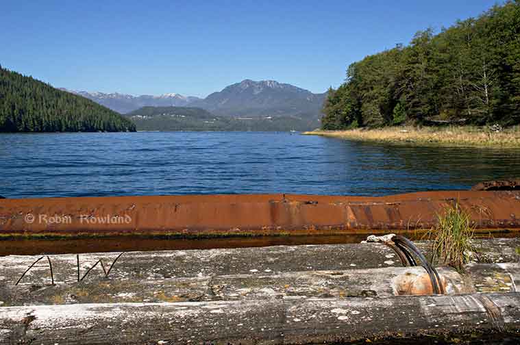
Clio Bay
Clio Bay, looking toward Douglas Channel, September 14, 2013. (Robin Rowland/Northwest Coast Energy News)


Haisla First Nation Chief Counsellor Ellis Ross says the Haisla made the proposal to the KM LNG project, a partnership of Chevron and Apache, to use the marine clay to cover the thousands of logs at the bottom of Clio Bay after years frustration with the Department of Fisheries and Oceans and the BC provincial government, which for decades ignored requests for help in restoring almost fifty sunken log sites in Haisla traditional territory.

The problem is that remediation of the hundreds of sites on Canada’s  west coast most containing tens of thousands of sunken logs has been so low on DFO’s priority list that even before the omnibus bills that gutted environmental protection in Canada, remediation of sunken log sites by DFO could be called no priority.

Now that the KM LNG has to depose of a total of about 3.5 million cubic metres of marine clay and possibly other materials from the Bish Cove site, suddenly log remediation went to high priority at DFO.

The controversy is rooted in the fact that although the leaders of the Haisla and the executives at Chevron knew about the idea of capping Clio Bay, people in the region, both many residents of Kitimat and some members of the Haisla were surprised when the project was announced in the latest KM LNG newsletter distributed to homes in the valley.

Chevron statement

In a statement sent to Northwest Coast Energy News Chevron spokesperson Gillian Robinson Ridell said:

The Clio Bay Restoration Project  proposed by Chevron, is planned to get underway sometime in early 2014. The proposal is fully supported by the Federal Department of Fisheries and Oceans and the Haisla First Nation Council.  The project has been put forward as the best option for removal of the marine clay that is being excavated from the Kitimat LNG site at Bish Cove. Chevron hired Stantec, an independent engineering and environmental consulting firm with extensive experience in many major habitat restoration projects that involve public safety and environmental conservation.  The Haisla, along with Stantec’s local marine biologists, identified Clio Bay as a site that has undergone significant environmental degradation over years of accumulation of underwater  wood debris caused by historic log-booming operations. The proposal put forward by the marine biologists was that restoration of the marine ecosystem in the Bay could be achieved  if marine clay from Chevron’s facility site, was used to cover the woody debris at the bottom of the Bay. The process outlined by the project proposal is designed to restore the Clio Bay seafloor to its original soft substrate that could sustain a recovery of biological diversity.

Kitimat worried

Non-aboriginal residents of Kitimat are increasingly worried about being cut off from both Douglas Channel and the terrestrial back country by industrial development. These fears have been heightened by reports that say that Clio Bay could be closed to the public for “safety reasons” for as much as 16 months during the restoration project.

The fact that Clio is known both as a safe anchorage during bad weather and an easy to get to location for day trips from Kitimat has made those worries even more critical.

There is also a strong feeling in Kitimat that the residents were kept out of the loop when it came to the Clio Bay proposal.

In a letter to the District of Kitimat, DFO said:

Clio Bay has been used as a log handling site for decades which has resulted in areas of degraded habitat from accumulations of woody debris materials on the sea floor. The project intends to cap impacted areas with inert materials and restore soft substrate seafloor. The remediation of the seafloor is predicted to enhance natural biodiversity and improve the productivity of the local fishery for Dungeness crab. The project area does support a variety of life that will be impact and therefore the project will require authorization from Fisheries and Oceans Canada for the Harmful Alteration, Disruption or Destruction (HADD) of fish and fish habitat.

The letter avoids the controversy over the use of marine clay but saying “inert material” will be used. That can only increase the worries from residents who say that not only clay but sand, gravel and other overburden from Bish Cove and the upgrade of the Forest Service Road may be used in Clio Bay. (The use of “inert material” also gives DFO an out if it turns out the department concludes the usual practice of using sand is better. That, of course, leaves the question of what to do with the clay).

Although Ellis Ross has said he wants to see large numbers of halibut and cod return to Clio Bay, the DFO letter only mentions the Dungeness Crab.
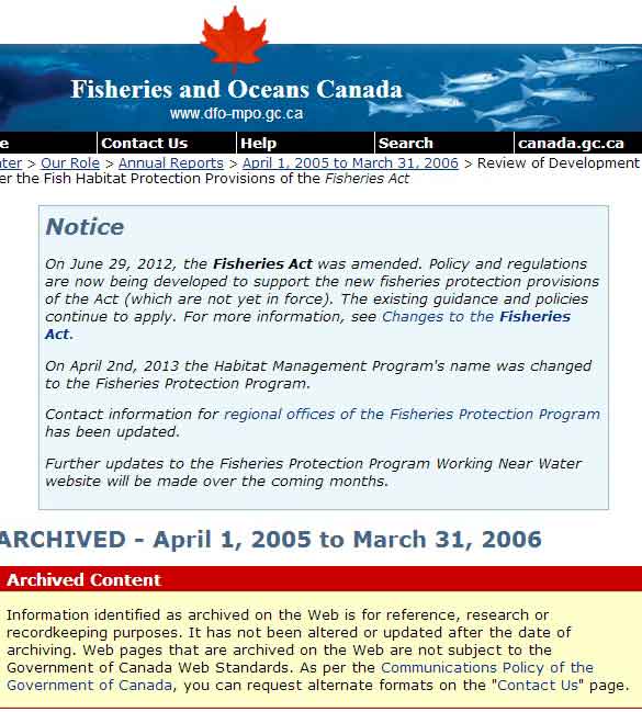
DFO website cites pending changes after the passage of the omnibus bills.

Try to search “remediation” on the DFO site and the viewer is redirected to a page that cites the omnibus bills passed by the Conservative government and says

On June 29, 2012, the Fisheries Act was amended. Policy and regulations are now being developed to support the new fisheries protection provisions of the Act (which are not yet in force). The existing guidance and policies continue to apply. For more information, see Changes to the Fisheries Act.

On April 2nd, 2013 the Habitat Management Program’s name was changed to the Fisheries Protection Program.

So, despite what communications officers for DFO and the Harper government may say, there was no policy then and there is no policy now on remediation of log sites. Given Harper’s attitude that LNG and possibly bitumen export must proceed quickly with no environmental barriers, it is likely that environmental remediation will continue to be no priority—unless remediation becomes a problem that the energy giants have to solve and pay for.

Alaska studies

On the other hand, the State of Alaska and the United States Environmental Protection Agency spent a decade at a site near Ketchikan studying the environmental problems related to sunken logs at transfer sites

Those studies led Alaska to issue guidelines in 2002 with recommended practices for rehabilitating ocean log dump sites and for the studies that should precede any remediation project.

The Alaska studies also show that in Pacific northwest coast areas, the ecological effects of decades of log dumping, either accidental or deliberate, vary greatly depending on the topography of the region, the topography of the seabed, flow of rivers and currents as well as industrial uses along the shoreline.

The Alaska policy is based on studies and a remediation project at Ward Cove, which in many ways resembles Clio Bay, not far from Kitimat, near Ketchikan.

The Alaska policy follows guidelines from both the US Environmental Protection Agency and the US Army Corps of Engineers that recommend using thin layers of “clean sand” as the best practice method for capping contaminated sites. (The Army Corps of Engineers guidelines say that “clay balls” can be used to cap contaminated sites under some conditions. Both a spokesperson for the Corps of Engineers and officials at the Alaska Department of Environmental Conservation told Northwest Coast Energy News that they have no records or research on using marine clay on a large scale to cap a site.)

The EPA actually chose Sechelt, BC, based Construction Aggregates to provide the fine sand for the Ward Cove remediation project. The sand was loaded onto 10,000 tonne deck barges, hauled up the coast to Ward Cove, offloaded and stockpiled then transferred to derrick barges and carefully deposited on the sea bottom using modified clam shell buckets.

The EPA says

Nearly 25,000 tons of sand were placed at the Ward Cove site to cap about 27 acres of contaminated sediments and 3 other acres. In addition, about 3 acres of contaminated sediments were dredged in front of the main dock facility and 1 acre was dredged near the northeast corner of the cove. An additional 50 acres of contaminated sediments have been left to recover naturally.

A report by Integral Consulting, one of the firms involved at the project estimated that 17,800 cubic metres of sand were used at Ward Cove.

In contrast, to 17,800 cubic metres of sand used at Ward Cove, the Bish Cove project must dispose of about 1.2 million cubic metres of marine clay at sea (with another 1.2 million cubic metres slated for deposit in old quarries near Bees Creek).

Studies at Ward Cove began as far back as 1975. In 1990 Alaska placed Ward Cove on a list of “water-quality limited sites.” The studies intensified in 1995 after the main polluter of Ward Cove, the Ketchikan Paper Company, agreed in a consent degree on a remediation plan with the Environmental Protection Agency in 1995. After almost five years of intensive studies of the cove, the sand-capping and other remediation operations were conducted from November 2000 to March 2001. A major post-remediation study was carried out at Ward Cove in 2004 and again in 2009. The next one is slated for 2015.

Deaf ears at DFO

“We need to put pressure on the province or Canada to cleanup these sites. We’ve been trying to do this for the last 30 years. We got nowhere,” Ellis Ross says. “Before when we talked [to DFO] about getting those logs and cables cleaned up, it fell on deaf ears. They had no policy and no authority to hold these companies accountable. So we’re stuck, we’re stuck between a rock and hard place. How do we fix it?”

Ross says there has been one small pilot project using marine clay for capping which the Haisla’s advisers and Chevron believe can be scaled up for Clio Bay.

Douglas Channel studies

The one area around Kitimat that has been studied on a regular basis is Minette Bay. The first study occurred in 1951, before Alcan built the smelter and was used as a benchmark in future studies. In 1995 and 1996, DFO studied Minette Bay and came to the conclusion that because the water there was so stagnant, log dumping there had not contributed to low levels of dissolved oxygen although it said that it could not rule out “other deleterious effects on water quality and  habitat`from log dumping.”

That DFO report also says that there were complaints about log dumping at Minette Bay as far back as 1975, which would tend to confirm what Ross says, that the Haisla have been complaining about environmentally degrading practices for about 30 years.

Ross told Northwest Coast Energy News that if the Clio Bay remediation project is successful, the next place for remediation should be Minette Bay.

A year after the Minette Bay study, DFO did a preliminary study of log transfer sites in Douglas Channel, with an aerial survey in March 1997 and on water studies in 1998. The DFO survey identified 52 locations with sunken logs on Douglas Channel as “potential study sites.” That list does not include Clio Bay. On water studies were done at the Dala River dump site at the head of the inlet on Kildala Arm, Weewanie Hotsprings, at the southwest corner of the cove, the Ochwe Bay log dump where the Paril River estuary opens into the Gardner Canal and the Collins Bay log dump also on the Gardner Canal.

In the introduction to its report, published in 2000, the DFO authors noted “the cumulative effect of several hundred sites located on BC coast is currently unknown.”

DFO list of sunken log sites on Douglas Channel   (pdf)

Since there appears to have been no significant follow-up, that cumulative effect is still “unknown.”

In 2000 and 2001, Chris Picard, then with the University of Victoria, now Science Director for the Gitga’at First Nation did a comparison survey of Clio Bay and Eagle Bay under special funding for a “Coasts Under Stress” project funded by the federal government. Picard’s study found that Eagle Bay, where there had been no log dumping was in much better shape than Clio Bay. For example, Picard’s study says that “Dungeness crabs were observed five times more often in the unimpacted Clio Bay.”

Although low oxygen levels have been cited as a reason for capping Clio Bay, Picard’s study says that “near surface” oxygen levels “did not reliably distinguish Clio and Eagle Bay sediments.” While Clio Bay did show consistent low oxygen levels, Eagle Bay showed “considerable interseasonal variation” which is consistent with the much more intensive and ongoing studies of oxygen levels at Wards Cove.

Chevron’s surprise

It appears that Chevron was taken by surprise by the controversy over the Clio Bay restoration. Multiple sources at the District of the Kitimat have told Northwest Coast Energy News that in meetings with Chevron, the company officials seemed to be scrambling to find out more about Clio Bay.

This is borne out by the fact, in its communications with Northwest Coast Energy News, Chevron says its consulting firm, Stantec has cited just two studies, Chris Picard’s survey of Clio Bay and a 1991 overview of log-booming practices on the US and Canadian Pacfic coasts. So far, Chevron has not cited the more up-to-date and detailed studies of Ward Cove that were conducted from 1995 to 2005.

Chevron says that Stantec marine biologists are now conducting extensive field work using divers and Remote Operated Vehicle surveys to “observe and record all flora and fauna in the bay and its levels of abundance. Stantec’s observations echoed the previous studies which determined that the massive amount of wood has harmed Clio Bay’s habitat and ecosystem.”

In its statement to Northwest Coast Energy News, Chevron cited its work on Barrow Island,  in Western Australia, where the Chevron Gordon LNG project is on the same island as a highly sensitive ecological reserve. Chevron says the Australian site was chosen only after a thorough assessment of the viability of other potential locations, and after the implementation of extensive mitigation measures, including a vigorous quarantine program for all equipment and materials brought on to the Barrow island site to prevent the introduction of potentially harmful alien species.

Reports in the Australian media seem to bare out Chevron’s position on environmental responsibility. Things seem to be working at Barrow Island.

Robinson went on to say:

Those same high environmental standards are being applied to the Kitimat LNG project and the proposed Clio Bay Restoration project. The proposed work would be carried out with a stringent DFO approved  operational plan in place and would be overseen by qualified environmental specialists on-site.

The question that everyone in the Kitimat region must now ask is just how qualified are the environmental specialists hired by Chevron and given staff and budget cuts and pressure from the Prime Minister’s Office to downgrade environmental monitoring just how stringent will DFO be monitoring the Clio Bay remediation?

Alaska standardsIn the absence of comprehensive Canadian studies, the only benchmark available is that set by Alaska which calls for:Capping material, typically a clean sand, or silty to gravelly sand, is placed on top of problem sediments. The type of capping material that is appropriate is usually determined during the design phase of the project after a remediation technology has been selected. Capping material is usually brought to the site by barge and put in place using a variety of methods, depending on the selected remedial action alternative.

Thick Capping

Thick capping usually requires the placement of 18 to 36 inches of sand over the area. The goal of thick capping is to isolate the bark and wood debris and recreate benthic habitat that diverse benthic infauna would inhabit.

Thin Capping

Thin capping requires the placement of approximately 6 – 12 inches of sand on the project area. It is intended to enhance the bottom environment by creating new mini-environments, not necessarily to isolate the bark and wood debris. With thin capping, surface coverage is expected to vary spatially, providing variable areas of capped surface and amended surface sediment (where mixing between capping material and problem sediment occurs) as well as limited areas where no cap is evident.

Mounding

Mounding places small piles of sand or gravel dispersed over the waste material to create habitat that can be colonized by organisms. Mounding can be used where the substrate will not support capping.

[rps-include post=5057]

Clio Bay Editorial:Hire the experts. This is not the time to be learning on the job

Special report: Clio Bay cleanup: Controversial, complicated and costly

Editorial:

Hire the experts. This is not the time to be learning on the job.

Everyone in the Kitimat and Kitamaat Village are facing a dilemma, a dilemma that should have been solved a year ago, when it was first known that the KM LNG project at Bish Cove had grossly underestimated the amount of marine clay and other material that has to be removed for the liquified natural gas terminal, a total of about 3.5 million metric tonnes.

The Haisla and Chevron are proposing that much of the clay be deposited over sunken logs in Clio Bay.

Chevron, which only took over operations at KM LNG in December 2012, is still learning on the job.

When the Clio Bay capping plan became public, far too late in the process, only then did Chevron begin to take a serious look public worries about the environmental problems that might result from depositing all that marine clay in Clio Bay.

Chevron hired Stantec, a well-known international  consulting firm with close ties to the energy industry and some experience in remediation to evaluate Clio Bay. Although Chevron said in a statement that Stantec is a company  “with extensive experience in many major habitat restoration projects,” it appears that Stantec, in the case of Clio Bay, is a jack of all environmental trades and master of none, just learning on the job.

In answer to questions by Northwest Coast Energy News, Chevron cited two studies supplied to them by Stantec. One was Chris Picard’s (now with the Gitga’at First Nation) study of Clio Bay which anyone can find by using a Google Search. The second was an overview chapter of west coast North American logging practices from a book published 22 years ago.

Any of the web saavy undergraduate journalism students I once taught at Ryerson University could have done better. This semi-retired reporter, without the resources he once had in a major newsroom, easily found the studies of the log filled Ward Cove, the State of Alaska’s recommended remediation practices, the capping procedures recommended by the US Army Corps of Engineers and more. Chevron did not mention Stantec citing the 1995 DFO study of nearby Minette Bay which can easily be found on the DFO website.

A letter from Fisheries and Oceans to District of Kitimat Council only mentions Dungeness crab and not the Haisla desire to restore halibut and cod to Clio Bay. That can only raise suspicions that the DFO is also depending solely on Chris Picard’s limited survey of Clio Bay.

In Alaska, at Ward Cove, there were almost five years of studies on the ocean environment before part of the cove was dredged and parts of the cove with thousands of logs there were capped with fine sand.

The people of Kitimat and Kitamaat want the LNG project to proceed. Everyone wants a clean and sustainable ocean enviroment, whether in Clio Bay, Minette Bay or down Douglas Channel. The problem of that 3.5 million cubic metres of marine clay must be handled in a timely fashion so the LNG terminal can move to the next step in the coming months. There is no time for five years of studies before proceeding.

This site would not normally endorse one large corporation over another.

There isn’t time for Chevron and Stantec to be learning on the job, its technicians racing in their boats between Clio Bay and Bish Cove trying to figure out what is going on and casually asking people what they think. No time at all.

The clock is ticking. Chevron and Apache, in partnership with both the Haisla and the District of Kitimat, should immediately hire the companies that do have the expertise in remediating a northwest Pacific coast bay filled with sunken logs, the companies that cleaned up Ward Cove in Alaska. Integral Consulting was the main environmental consulting contractor at Ward Cove, assisted by another large firm, Exponent  and by Germano and Associates, a company that  according to its website specializes in “rapid seafloor reconnaissance”. Both Integral and Exponent are, like Stantec, giant international consulting firms.  In this case, experience has to count. While Stantec’s website does list remediation projects, none are similar to Clio Bay.

A letter from Fisheries and Oceans to the District of Kitimat says that:

Chevron will be required to conduct a pre-construction, construction and post construction monitoring program. Pre-construction monitoring will include collection of baseline information that will be used to assess effectiveness monitoring during and at the completion of the project. Water quality monitoring for turbidity and total suspended solids will be undertaken during construction to determine if established performance criteria are met.

From the reports available from both the EPA and the State of Alaska it appears that the companies that cleaned up Ward Cove did just what DFO is asking, assess and monitor.  Another reason to hire the experts rather than the newbies.

Why a three way partnership? Chevron/Apache and the Haisla Nation are already partners in the Clio Bay plan. Adding the District of Kitimat would establish trust and make sure that the results of any scientific and engineering studies, plans and operations would be available to the people of Kitimat (as well as some Haisla members who feel they were excluded) as part of the ongoing process. The partnership would make up for the lack of transparency up until now, make sure the public is kept up-to-date and not just by Chevron’s and DFO’s communications people since reports to the District could be reviewed by the engineering staff and members of council.

It is likely that those companies that worked at Ward Cove could quickly let everyone know whether the idea of capping at Clio Bay with marine clay is a viable option and if it is viable how to do it properly rather than just dumping the clay from a barge using a hose. If marine clay is not viable for Clio Bay, it is likely that those firms could advise whether one of the original plans, to dump the clay in the deep ocean, is a better solution, or if there is another alternative that no one has thought of.

Kitimat and Kitamaat are lucky. The recommended practice for capping sunken logs is using sand. There is here a ready source at the Kitimat Sand Hill. If marine clay is not a viable option, or for future projects, the Sand Hill can easily be used to fulfill the aims of both the Haisla Nation and the residents of Kitimat to clean up Clio Bay, Minette Bay and eventually all 50 other sites identified along Douglas Channel by DFO in 1997. Those consulting firms have the expertise in this area and that expertise should be utilized.

Learning from the job

Even though sand has a track a record in capping, using marine clay from Bish Cove  to cap the logs at Clio Bay is probably a good idea, after all that marine clay was once at the bottom of the Ice Age Douglas Channel.

The use of sand for capping sites is well-known, there are established engineering parameters. At Ward Cove, there were studies of the angle of the slopes and how much weight of sand that the debris could hold.  Sand is very different from marine clay. At the moment, there are no engineering parameters for marine clay. It appears that no one has thought of doing slope analysis and load bearing engineering studies at Clio Bay.

Marine clay is a potential cap for all the sunken log sites on Douglas Channel and on the whole Pacific coast from Oregon to Alaska.  That means that Clio Bay is a pilot project that should be planned as carefully as possible, within the time constraints needed for construction of the LNG terminal, but not regarded as a rush job to get rid of that clay.  That means taking the time needed to do all the necessary scientific and engineering studies before the first drop of clay heads to the bottom. That is another reason to hire experts who actually know what they are doing so everyone can learn from the job.


Standards

No matter how the cleanup of Clio Bay proceeds, KM LNG, the Haisla and the District of Kitimat are facing another dilemma. What standards and benchmarks should be applied to the project?

By law, the Department of Fisheries and Oceans is responsible and will, of course, be monitoring the cleanup.

Despite assurances in a letter to the District of Kitimat, it is clear that DFO too is learning on the job.

At the moment, DFO has no standards for remediation, because the Conservative omnibus bills have gutted environmental standards in Canada. Even before the omnibus bills and the LNG rush, cleaning up log dumps was on the DFO low low priority list.

The letter from DFO to District of Kitimat council shows what knowledgeable sources have told us, DFO will be navigating Clio Bay from a desk in Kamloops (of all places). The same sources say that the Prince Rupert office of DFO, which has the expertise on the northwest coast is out of the loop on this project. The residents of the northwest coast already know there are not enough fisheries officers to properly monitor the coast. DFO “estimates” the annual recreational halibut catch (perhaps by using fish entrails rather than the traditional chicken?). DFO has retired or laid off many scientists who have studied the coast. Others have left on their own. The remaining scientists are muzzled by the Harper government, with anything they could say filtered by the Prime Minister’s Office, so it is likely that no one in the northwest will actually trust what they say.

Normally in a free and democratic society, the government tells local residents when a major operation like the remediation of Clio Bay is going to occur.  In this case, Fisheries and Oceans did not tell anyone in Kitimat anything until the District of Kitimat Council requested information.

On Monday, Sept. 30, a representative of Chevron will make a presentation to District Council. DFO did nothing more than send a letter that said: “Regretfully, Fisheries and Oceans Canada is unable to attend the scheduled council meeting.” Nobody, in the whole department? One is tempted to say, “That’s not good enough.” Then you remember that if DFO appeared before Council, the presenter would have to face possibly awkward questions from both members of Council and the media. That just doesn’t happen in Stephen Harper’s Canada, not in Ottawa and certainly not in Kitimat.

Despite what DFO has said in its letter, this regulatory vacuum leaves the Kitimat region no choice. Since Canada has no standards, when the Clio Bay project proceeds, the best available standards are those set by Alaska, which has the same type of coast and climate. The Clio Bay clean up should therefore be measured against those Alaska standards.
[rps-include post=5057]

Clio Bay: Links and Documents

Links and documents relating to sunken logs and site remediation

Note many, not all, external links are to pdf files.

Canada

DFO study of sunken log sites in Douglas Channel

DFO Study Dissolved oxygen cycle in Minette Bay

Impact of Wood debris in British Columbia estuaries

Chris Picard’s study of Clio and Eagle Bays as posted on the University of Laval website

United States

Links

Alaska Department of Environmental Conservation

Environmental Protection Agency

Ketchikan Paper Company
This is the EPA Web site on the Ward Cove cleanup and remediation with numerous documents.

EPA capping guidance
EPA contaminated sediment capping guidance

US Army Corps of Engineers

US Army Corps of Engineers capping guidance

Documents

Alaska log site remediation guide  (pdf)

EPA study of dissolved oxygen in Ward Cove (pdf)

Marine Log Transfer Facilities and Wood Waste (pdf)

Academic paper by Ward Cove consultants Geramano & Associates on sediments in Ward Cove and Thorne  Bay, Alaska.

Ward Cove Sediment Remediation Project Revisited

Academic paper by Ward Cove consultants Integral Consulting


 Other Links

Kitimat LNG (KM LNG)

Stantec

Stantec remediation project page

Integral Consulting

Integral Consulting Ward Cove web page

Exponent 

Exponent Ward Cove web page

Exponent LNG Safety web page

Germano & Associates

(Note not all documents used in this report are available online. Some sent to NWCEN are too large to upload)


[rps-include post=5057]

Enbridge files massive river oil spill study with the Joint Review Panel

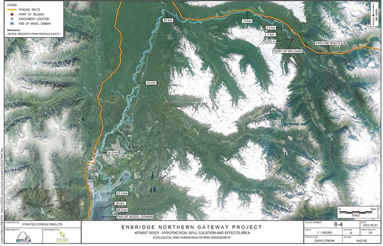
Kitimat River map from Enbridge study
A Google Earth satellite map of the Kitimat River used as part of Enbridge Northern Gateway’s oil spill modelling study.

Enbridge Northern Gateway today filed a massive 11-volume study with the Joint Review Panel outlining possible scenarios for oil spills along the route including the Kitimat and Morice Rivers in British Columbia.

The study, carried out by three consulting firms, Stantec Consuting and AMEC Environmental & Infrastructure both of Calgary and RPS ASA of Rhode Island, is called “Ecological and Human Health Assessment for Pipeline spills.”

Overall the models created by study appear to be extremely optimistic, especially in light of recent events, such as the damning report on by the US
National Transportation Safety Board and the finding of violations by the US Pipeline and Hazardous Material Safety Administration with Enbridge operations during the 2010 Marshall, Michigan, spill and subsequent cleanup difficulties encountered by Enbridge.

The executive summary of the report begins by saying

This document presents conservatively developed assessments of the acute and chronic risk to ecological and human receptors in the unlikely event of a full bore pipeline break on the proposed Enbridge Northern Gateway Pipeline project. Three representative hydrocarbon types (condensate, synthetic oil
and diluted bitumen) were evaluated with releases occurring to four different rivers representing a range of hydrological and geographic characteristics, under both low-flow and high-flow conditions. The analysis indicates that that the potential environmental effects on ecological and human health from each hydrocarbon release scenario could be adverse and may be significant. However, the probability of the releases as considered in the assessment (i.e., full bore rupture, with no containment or oil recovery) is low, with return periods for high consequence watercourses ranging from 2,200 to 24,000 years. Therefore, the significant adverse environmental effects as described in this report are not likely to occur.

So the study says that it is “conservative” that means optimistic, that a full bore pipelink break with no containment or recovery is “an unlikely event” and would probably occur every 2,200 and 24,000 years. Not bad for a pipeline project that is supposed to be operational for just 50 years.

The summary does caution:

The analysis has also shown that the outcomes are highly variable and are subject to a great many factors including the location of the spill, whether the hydrocarbons are released to land or directly to a watercourse, the size of the watercourse, slope and flow volumes, river bed substrate, the amount of suspended particulate in the water, environmental conditions (such as the time of year, temperature and wind speeds, precipitation, etc.), the types of shoreline soils and vegetative cover and most significantly, the type and volume of hydrocarbon released.

The highly technical study is Enbridge’s official response to those intervenors who have “requested additional ecological and human health risk assessment studies pertaining to pipeline spills” and a request from the Joint Review Panle for more information about “the long term effects of pipeline oil spills on aquatic organisms (including the sensitivity of the early life stages of the various salmon species), wildlife, and human health.”

The report presents modelling on the release of three hydrocarbons, diluted bitumen, synthetic oil and condensate at four river locations along the pipeline route for their potential ecological and human health effects, under two flow regimes (i.e., high and low flow), broadly representing summer and winter conditions.

Modelling was done for four areas:

• Chickadee Creek: a low gradient interior river tributary discharging to a large river system
located up-gradient from a populated centre within the Southern Alberta Uplands region
• Crooked River: a low gradient interior river with wetlands, entering a lake system within
the Interior Plateau Region of British Columbia
• Morice River: a high gradient river system along the western boundary of the Interior
Plateau Region of British Columbia
• Kitimat River near Hunter Creek: a high gradient coastal tributary discharging to a large
watercourse with sensitive fisheries resources, downstream human occupation, and discharging to the Kitimat River estuary

In one way, the study also appears to be a partial victory for the Kitimat group Douglas Channel Watch because the model for the Kitimat River is based on a spill at Hunter Creek, which has been the subject of extensive work by the environmental group, but the consulting study is markedly optimistic compared to the scenario painted by Douglas Channel Watch in its presentations to District of Kitimat council.

The study describes the Kitimat River:

The hypothetical release location near Hunter Creek is southwest of Mount Nimbus, in the upper Kitimat  River watershed, and flows into Kitimat River, then Kitimat Arm, approximately 65 km downstream. The area is in a remote location and maintains high wildlife and fisheries values. The pipeline crossing near Hunter Creek is expected to be a horizontal direction drilling (HDD) crossing. The release scenario
assumes a discharge directly into Kitimat River…

The streambed and banks are composed of coarse gravel, cobbles and boulders. Shoreline vegetation (scattered grasses and shrubs) occurs in the channel along the tops of bars. Vegetation is scattered on the channel banks below the seasonal high water mark and more developed (i.e., grasses, shrubs and trees) bove the seasonal high water mark.

Wildlife and fish values for the Kitimat River are high: it is important for salmon stocks, which also provide important forage for grizzly bears, bald eagles and osprey on the central coast. The Kitimat River estuary, at the north end of Kitimat Arm, also provides year-round habitat for some waterbirds and seasonal habitat for staging waterfowl.

There is considerable recreational fishing, both by local people and through fishing guides, on Kitimat River, its estuary and in Kitimat Arm. There is also likely to be a high amount of non-consumptive recreational activity in the area, including wildlife viewing, hiking and camping. The Kitimat River estuary, for example, is well known for waterbird viewing.

While no fish were captured at this location during the habitat survey, salmonoid fry and coho salmon were observed downstream. Previously recorded fish species in the area include chinook, coho and chum salmon, rainbow trout, Dolly Varden, and steelhead trout.

However, the next paragraph appears to show that a full bore rupture on the Kitimat River would have widespread consequences because it would cover a vast area of First Nations traditional territory, saying

Aboriginal groups with traditional territories within the vicinity of the Kitimat River hypothetical spill scenario site include the Haisla Nation, Kitselas First Nation, Kitsumkalum First Nation, Lax-Kw’alaams First Nation and Metlakatla First Nation.

It also acknowledges:

Oral testimony provided by Gitga’at First Nation and Gitxaala Nation was also reviewed in relation to this hypothetical spill scenario, although the traditional territories of these nations are well-removed from the hypothetical spill site.

The report then goes on to list “the continued importance of traditional resources” for the aboriginal people of northwestern BC.

especially marine resources. People hunt, fish, trap and gather foods and plants throughout the area and traditional foods are central to feasting and ceremonial systems. Food is often distributed to Elders or others in the community. Written evidence and oral testimony reported that Coho, sockeye, pink, and spring salmon remain staples for community members. Halibut, eulachon, herring and herring roe,
various species of cod, shellfish, seaweed, and other marine life are also regularly harvested and consumed, as are terrestrial resources, including moose, deer, beaver, muskrat and marten. Eulachon remains an important trade item. Written evidence provides some information on seasonality of use and modes of preparation. Seaweed is dried, packed and bundled and preserved for later use. Each species of
salmon has its own season and salmon and other fish are prepared by drying, smoking, freezing or canning. Salmon are highly valued and often distributed throughout the community…

Some areas used traditionally are not depicted geographically. Upper Kitimat River from the Wedeene River to the headwaters has long been used for trapping, hunting, fishing and gathering of various foods. Fishing, hunting and gathering activities take place along the lower Kitimat River and its tributaries. Marine resources are collected in Kitimat Arm, Douglas Channel, and Gardner Canal. Old village and
harvesting sites are located along the rivers and ocean channels in this vicinity.

Intertidal areas are important and highly sensitive harvesting sites that support a diversity of species. Many intertidal sites are already over harvested and are therefore vulnerable. Conservation of abalone has been undertaken to help the species recover. Some concern was expressed in oral testimony regarding the
potential for archaeological sites and the lack of site inventory in the area. Oral testimony made reference to the Queen of the North sinking and the potential for a similar accident to result in human health and environmental effects.

A spill at Hunter Creek

The model says that all three types of floating oil in Kitimat River under high-flow conditions would reach approximately 40 kilometres downstream from Hunter Creek while low-flow conditions showed variation.

Under what the study calls low flow conditions, most condensate would evaporate. The bitumen would cause “heavy shore-oiling” for the first 10 kilometres, with some oiling up to 40 kilometres downstream.

The most sedimentation would occur for synthetic oil, and the least for condensate. Synthetic oil under both flow conditions would have the largest amounts deposited to the sediments. This is because of the low viscosity of synthetic oil, which allows it to be readily entrained into the water where it may combine with suspended sediments and subsequently settle. Synthetic oil under high-flow conditions would result in the most entrained oil and so the most extensive deposition to the sediment. Diluted bitumen, for both flow conditions, would result in the most deposited on shorelines, with the remainder (except that which evaporated or degraded) depositing to the sediments.
The condensate also would also have significant entrainment, but higher winds prevailing in under low flow conditions would enhance evaporation and rapidly lower concentrations in the water as compared to high-flow conditions. In all scenarios, a large amount of entrained oil and high concentrations of dissolved aromatics would move down the entire stretch of Kitimat River and into Kitimat River estuary.

Long term scenario

The modelling appears to be extremely optimistic when it reaches four to six weeks after the pipeline breach, especially in light of the continued cleanup efforts in Michigan, estimating that the “fast-flowing” nature of the Kitimat River would disipate all the different forms of hydrocarbon in the study saying

 a fast-flowing coastal river like Kitimat River, with gravel or cobble bottom would be affected by a large volume of crude oil released in a short period of time.

Oiling of shoreline soils is heavy in the reaches between the release point and 10 km downstream, becoming lighter to negligible beyond 10 km. Deposition of hydrocarbons to river sediment is greatest for the synthetic oil and diluted bitumen (high flow) scenarios extending up to 40 kilometres downriver, with predicted hydrocarbon concentrations in sediment approaching 1,000 mg/kg dry weight. Deposition of hydrocarbons to river sediment is considerably lighter for the diluted bitumen (low flow) and condensate scenarios. In these scenarios, oiling of river sediment is negligible….

It says that within four weeks of the end of the acute phase of the spill scenarios, concentrations in river sediments and river water would decline becoming quite low at the end of two years.

As for the affects on plants and invertebrates:

Oiling of shorelines would be extensive, particularly at assessment locations within 10 kilometres of the pipeline break location, under both the high and low flow scenarios, for synthetic oil and condensate. High loadings occur as far as 25 kilometres downstream, again asusming that damage would begin to disipate after four weeks declining over the next one to two years. Predicted effects are generally less severe for the diluted bitumen spill scenarios, due to lower expected loading of oil onto shorelines. Low to negligible shoreline oiling would occur for Kitimat River under most of the scenarios at the 40 kilometres assessment location and points downstream. Based on this assessment, very little oiling of shorelines would extend to the estuary and the environmental effects would be minimal.

The study goes on to say that the “model suggests that there would be no significant risk to fish health based upon chronic exposure to petroleum hydrocarbons  for the oil spill scenarios in Kitimat River or the potentially affected areas within the estuary, either at four weeks or one to two years following the hypothetical spill events. Risk to developing fish eggs in Kitimat River and estuary at four weeks and one to two years again indicate no significant risk to developing fish eggs in spawning gravels.”

It also claims that “chronic risks” to wildlife would be minimal, with some elevated risk for “muskrat, belted kingfisher, mallard duck, spotted sandpiper and tree swallow,” if they were exposed to synthetic oil. The muskrat, mallard duck and spotted sandpiper
could be vulnerable to bitumen and diluted bitumen.

It then claims that “no significant effects of chronic exposure (to all hydrocarbons) would occur for grizzly bear, mink, moose, river otter, bald eagle, Canada goose, herring gull or great blue heron for the Kitimat River hydrocarbon spill scenarios.”

Again, it appears from the sutdy that the spotted sandpiper would be most vulnerable to “bulk weathered crude oil exposure” includingcondensate, diluted bitumen and synthetic oil.

For the Kitimat section it concludes:

In the unlikely event of an oil spill, recovery and mitigation as well as the physical
disturbance of habitat along the watercourse would be likely to substantially reduce the exposure of wildlife receptors to hydrocarbons as compared to the scenarios evaluated here.

Link to Volume One of the Enbridge Northern Gateway Report Ecological and Human Health Assessment for Pipeline Spills