As related in Gordon Robinson’s Tales of the Kitamaat, the First Peoples living on the coast of what is now British Columbia ventured up what is now called Douglas Channel perhaps from either Bella Bella in Heiltsuk traditional territory or from Prince Rupert in Tsimshian traditional territory.
The young men on the expedition up the Kitimat Arm spotted what they thought was a huge monster kilometres ahead with a large mouth that was constantly opening and closing. The sight was so terrifying that the men fled back to their homes and dubbed the Kitimat Arm as a place of a monster.
Later a man named Hunclee-qualas accidentally killed his wife and had to flee from the vengeance of his father-in-law. Knowing he had to find a place where no one could find him, he ventured further up the Kitimat Arm. There he discovered that the “monster” was nothing more than seabirds, probably seagulls, perhaps feasting on a spring oolichan run.
He settled along the shore of what is now the Kitimat River and found a land of plenty, with fish, seals, game as well as berries and other natural products of the land. Eventually he invited others to join him, which began the Haisla Nation and he became their first chief.
Let’s examine the new evidence so far.
Settlement along the coastal “kelp highway” between 18,000 and 16,000 years ago, followed by a warm spell 14,500 years ago
It’s now fairly certain that the First Peoples first began to settle along the coast by following the “kelp highway” perhaps as early as 18,000 years ago and certainly by 14,000 years ago. Haida Gwaii was ice free, except for some mountain glaciation as early as 16,500 years ago. At about 14,500 years ago there was a warming spell which forced the glaciers to retreat, brought higher sea levels and the arctic like tundra ecosystem would have been replaced, at least for a time, by forests. There is the discovery of a Heiltsuk settlement dated to 14,000 years ago. At that time almost all of the coast would have been free of glacial ice but there were still glaciers in the fjords, including the Kitimat Arm which would mean there could be no permanent settlement in the “inland coast” and the interior.
(Science)
The cooling period from 14,000 to 11,700 years ago confines settlement to the coast
The cooling periods (with occasional warmer times) from about 14,000 years ago to about 11,700 years ago meant that settlement would largely have been confined to the coast for about two and half millennia. The culture of the coastal First Peoples would have been well established by the time the glaciers began the final retreat.
(Remember that it is just 2,000 years from our time in 2017 back to the height of the Roman Empire under Augustus Caesar).
It is likely that the cooling periods also meant that some descendants of initial settlers likely headed south for relatively warmer climates. Rising sea levels meant that the initial settlement villages would likely have been abandoned for higher ground.
A second period of rapid warming 11,700 years ago which opens up the interior fjords and valleys
At the end of what geologists call the Younger Dryas period, about 11,500 years ago, the climate warmed, the glaciers retreated further, in the case of Kitimat, first to what is now called Haisla Hill, then to Onion Flats and finally to Terrace.
Large glacial sediment river deltas filled with fresh melt water from retreating ice
The most important confirmation of the story of Hunclee-qualas’s exile is the account of the monster, the birds and the oolichan run.
The new scientific evidence, combined with earlier studies, points to the fact that the glacial melt water carried with it huge amounts of glacial sediment that created vast river deltas in coastal regions of the Northern Hemisphere.
That means around 10,000 years ago, when the Kitimat Valley was ice free and the new forest ecosystem was spreading up the valley, the Kitimat River estuary was likely to have been much larger than today. It could have been a vast delta, which would have quickly been repopulated with fish, including salmon and oolichan. That rich delta ecosystem could have supported a much larger population of seabirds than the smaller estuary in recent recorded history.
Snow geese by the thousands in the Sacramento-San Joaquin Bay Delta/ CrunchySkies/Wikimedia Commons/Creative Commons License
The story of the monster those first travelers saw far off is highly plausible. Even today in huge, rich deltas elsewhere in the world, seeing hundreds of thousands of birds in flight over a wetland is fairly common. (For a description of what a Kitimat River delta may have been like thousands of years ago, see KCET’s story on the Sacramento-San Joaquin Bay Delta and what that delta was like 6,000 years ago)
The First Peoples had had well established communities for up to four thousand years before the Kitimat Valley’s metres of thick ice had melted away. For the first period, while the ecosystem regenerated, for the people of the coast coming up Douglas Channel to the valley would not have been worth it, there would be little to find in terms of fish, game or forest resources.
A Snow Goose flock near the Skagit River Delta, WA./ Walter Siegmund/Wikimedia Commons
The change from tundra to a rich forest environment
Eventually as the forest regenerated, the streams filled with salmon and oolichan; the bird population including gulls, geese and eagles, found a new feeding ground; bears, deer and other animals arrived. The Kitimat region would have been an attractive place to explore and hunt. It may be the monster story did keep people away until Hunclee-qualas had to find a place to hide and discovered a new home just at a time that might be called an ecological optimum with new forests stretching back along the valley to what is now Terrace.
The river delta shrinks back to the current estuary
If a vast Kitimat River delta did stretch further down the Channel than it does in 2017, it likely shrank back in the subsequent millennia. Eventually the mass of glacial sediment that came downstream after the retreat of the ice would diminish, but not stop entirely. The estuary is still rebuilt from sediments washed downstream but that sediment doesn’t match other rich deltas elsewhere such as the Nile in Egypt. With that regeneration of the delta slower and smaller than in the first centuries of Haisla settlement, at the same time the land surface rebounded from the weight of the ice, perhaps creating the Kildala neighborhood. The ocean level rose, drowning and eroding part of the old delta, creating the estuary we know today.
As the authors of the paper on the First Peoples’ settlement note, most of the archaeological evidence of early coastal settlement is now likely many metres below the surface of the ocean but deep ocean exploration may uncover that evidence. As the scientific team on the second paper say, they are now working on detailed studies of the glacial retreat from the coastal mountain region which may, when the studies are complete, change the timeline
While waiting for further evidence from archaeology and geology it is safe to say that the stories of the monster and later Hunclee-qualas’s discovery of the Haisla homeland are even more compelling than when Gordon Robinson wrote Tales of the Kitamaat. We can now speculate that there was once, stretching from Haisla Hill far down the Channel, a vast, varied rich, river estuarine delta that supported hundreds of thousands of seabirds, which if they took the wing in unison, would have made those unwary travelers millennia ago, really think that there was a giant monster waiting to devour them at the head of the Kitimat Arm.
If some travellers, perhaps about 12,000 years ago, had headed up what is now called Douglas Channel, around the north end of Hawkesbury Island they likely would have seen a glacial retreat driven by a warming planet, something very familiar to the television viewers of 2017, video of 21st century coastal Greenland, where massive glaciers are calving ice bergs into the ocean.
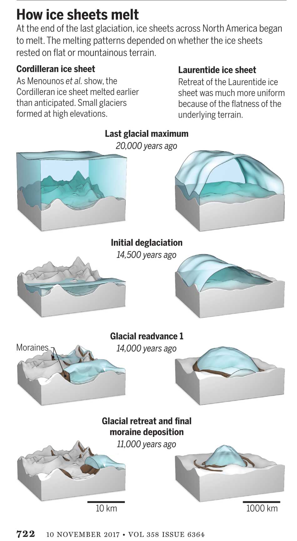
The history of rapid glacial retreat over several thousand years from the interior and coastal British Columbia at the end of the last Ice Age is now becoming a crucial indicator of what may happen to both Greenland and the Antarctica. Under the current ice sheets both Greenland and parts of Antarctica are mountain ranges similar to those here in British Columbia. According to new research published to today in Science, that may indicate what could happen as those ice sheets melt and how that will affect volatile climate change.
The paper written by Brian Menounos of the University of Northern British Columbia and co-authors indicates that the glacial retreat in BC was faster than previously believed, beginning about 14,000 years ago. That left some parts of coastal and western BC ice free, rather than beginning 12,500 years ago as previously estimated. The last Ice Age probably reached its maximum coverage about 20,000 years ago.
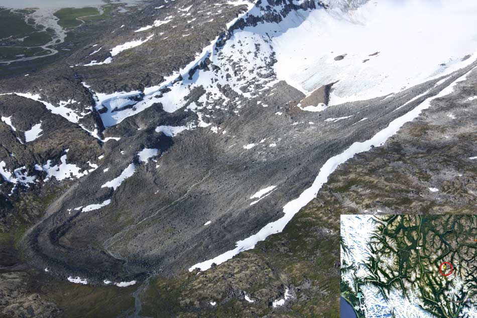
One of the cirque moraines at the end of a glacier studied by Brian Menounos and his team. It is in northern British Columbia just south of the Yukon border. ( Brian Menounos/Science plus Google Earth)
The decay of the ice sheet was complex, partly due to presence of mountainous terrain and also because Earth’s climate rapidly switched between cold and warm conditions during the end of the last Ice Age.
One of the factors that may have triggered a climate change back to colder conditions was a massive outflow of cold, fresh water from coastal British Columbia, which may have affected ocean currents.
What geologists call the Cordilleran ice sheet once covered all of present-day British Columbia, Alaska and the north Pacific United States. How the Cordilleran ice sheet responded to climate change was different from the Laurentide ice sheet which covered the flatter terrain (prairie and the Canadian Shield) of central North America. The Cordilleran ice sheet is about the same size as the current Greenland ice sheet.
“Our work builds upon a rich history of collaborative research that seeks to understand when and how quickly the Cordilleran ice sheet disappeared from Western Canada,” Menounos says. “Projected sea level rise in a warming climate represents one of the greatest threats to humans living in coastal regions. Our findings are consistent with previous modeling studies that show that abrupt warming can quickly melt ice sheets and cause rapid sea level rise.”
One of the co-authors of the paper is John Clague, now a professor emeritus of Earth Science at Simon Fraser University who studied the glaciation patterns in the Kitimat valley and Terrace in the 1970s when he worked for the Geological Survey of Canada.
Earlier researchers, including Clague, relied on radiocarbon dating to establish when the ice sheets disappeared from the landscape. The problem is that radiocarbon dating may not work in higher alpine regions where fossil organic matter is rare (above the tree line).
Menounos and the researchers used surface exposure dating – a technique that measures the concentration of rare beryllium isotopes that accumulate in quartz-bearing rocks exposed to cosmic rays – to determine when rocks first emerged from beneath the ice. If the rocks are under an ice sheet that means they are not exposed to cosmic rays, and thus measuring the beryllium isotopes can indicate when the retreating ice exposed the rocks to the cosmic rays.
The scientists studied small “cirque moraines” found only beyond the edge of modern glaciers high in the mountains, and valley moraines.
The alpine cirque moraines could not have formed until after the Cordilleran ice sheet had retreated. Menounos and his team show that several alpine areas emerged from beneath the ice sooner than previously believed. Then once the mountain peaks emerged from the thinning ice, new, smaller glaciers grew back over the high-elevation cirques at the same time that remnants of the ice sheet “reinvigorated” in the valleys during subsequent climate reversals
Most of the work of the team was done in the interior of British Columbia, the Yukon and Northwest Territories. Menounos says that new, similar work is being done on the mountains of the coastal region which will be published when the research is complete.
At its maximum, the Cordilleran ice sheet likely extended from what is now the mainland coast across Hecate Strait to the east coast of Haida Gwaii.
Starting about 14,500 years ago, the planet entered a phase of warming, with the average temperature rising about 4 degrees Celsius over about a thousand years. The Cordilleran ice began to thin rapidly leaving what the paper calls a “labyrinth of valley glaciers,” which then allowed the alpine glaciers to re-advance.
Diagram from Science shows how the glaciers retreated at the end of the last Ice Age, with the mountainous Cordilleran ice sheet behaving differently from the central North American Laurentide ice sheet (Science)
The scientists have suggested the rapid ice loss, beginning 14,500 years ago, came relatively quickly in geological time, perhaps just 500 years. That may have then contributed to subsequent Northern Hemisphere cooling through freshwater rushing into the ocean. That melt water disrupted the overturning ocean circulation of cold and warm water. That led to a new cooling period that lasted from about 14,000 to 13,000 years ago. (Similar to the completely fictional scenario in the movie The Day After Tomorrow, where the cooling happens in days not centuries).
That same outflow could have raised then existing sea levels by two and half to three metres, Menounos says. (The overall sea level on Earth rose about 14 metres by the end of the Ice Age)
Then the climate reversed again, first briefly warming and then in a period that saw another abrupt change back to cooler conditions which geologists call the Younger Dryas, The Younger Dryas occurred beginning about 12, 900 years ago to about 11,700 years ago, when warming began again. The Dryas is named after a wildflower that grows in arctic tundras.
The study indicates that the First Peoples could not have settled the interior of what is now British Columbia prior to the Younger Dryas, but it is likely as was explored in a paper last week in Science that the First Peoples were able to come down the “kelp highway” on the coast by at least 14,000 years ago.
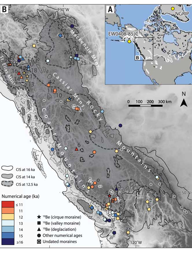
Map of British Columbia showing the extent of the glaciation during the last Ice Age and now the ice retreated. The coloured graphics are where the study was done mostly in the interior of BC and the age of the deposits. KA means kilo-years or thousand years ago. (Science)
So what happened in Douglas Channel?
So what does the new study of glacial retreat mean for the history of Douglas Channel?
John Clague studied the Douglas Channel, the Kitimat Valley and the Terrace area in the 1970s and was one of the co-authors of the current study that provides a new timeline for the retreat of the glaciers on the British Columbia coast.
He says that the timeline from his work in the 1970s with radio carbon dating of fossilized organic material is fairly consistent with the new work by Brian Menounos of the University of Northern British Columbia using the beryllium isotope technique.
The paper, Clague says, is more of a general commentary on the last stages of the decay of the Cordilleran ice sheet.
“At the time we’re taking about in the paper, there was ice in the corridor between Kitimat and Terrace.
“What we see in detail based on the work I did ages ago, is the retreat of the glacier from the Kitimat Arm back to the north towards Terrace [in the Young Dryas ]. It occasionally stabilized and the melting ice discharged a lot of sediment into that marine embayment.
Based on his original work and the new study Clague says at the time, the mountains are beginning to become ice free but there was still ice in the major valleys such as the Skeena Valley and the corridor south of Terrace towards Kitimat.
“They’re overlapping stories.” Clague says.
“The ice sheet hadn’t completely disappeared at the time Brian is focusing on,” Clague says. “His point is that a lot of the mass of the ice sheet appeared to be thinning and through marginal retreat from Haida Gwaii and some of the islands off the mainland back toward the mainland itself. So we’re trying to put a chronology on it, as to the various steps in the glacial decay.”
The work seems to indicate that the final ice sheet retreat happened in four stages around 12,000 to 11,000 years ago. “I was interested in the detailed reconstruction of the ice front tracked north from Kitimat you see a number of periods when it stabilized long enough to build up very large deltas and braided melt water plains,” Clague says.
The first moraine is Haisla Hill in Kitimat, where the glaciers discharged large amounts of sediment into what is now Douglas Channel. The second is the hill leading to what is called Onion Flats, the third is the flat area where the Terrace Kitimat Regional Airport now is and the final stage of glacial retreat created the “terraces’ around Terrace and Thornhill.
“It’s interesting that in this area there was so much sediment discharged into the sea remarkably for the time over which the ice was retreating through the area. It had to have been a major kind of discharge point of water from the ice sheet south from Terrace towards Kitimat otherwise you wouldn’t get that huge amount of sediment deposited probably over a period of a thousand years. Then it retreated again to just north of the airport and anchored there for a while and we found evidence for a final last gasp upstream around Thornhill and that kind of near Terrace.”
“At that time some of the high elevation glaciers were re-energized and readvanced, but it probably didn’t affect the overall health of the ice sheet itself It’s such a big mass of ice that it doesn’t respond quickly to such a brief cooling so what we’ve done in many places is these glaciers actually advanced up against ‘the dead ice’ an ice sheet that was lower in elevation.”
At the times the oceans rose at the end of the Ice Age, there were “sea corridors” between Kitimat and Terrace and also in the Skeena Valley. “So you can imagine there were arms of the sea extending to Terrace from two directions almost making that area which is now part of the mainland an island.” But the region likely never did become a true island, Clague says because as the ice sheets retreated,, they were also shedding large amounts of sediment that would become land area at the same time as the earth’s crust was rebounding once it was freed from the weight of the ice sheet.
UPDATED with comments from District of Kitimat, Terrace and the Gitga’at Nation
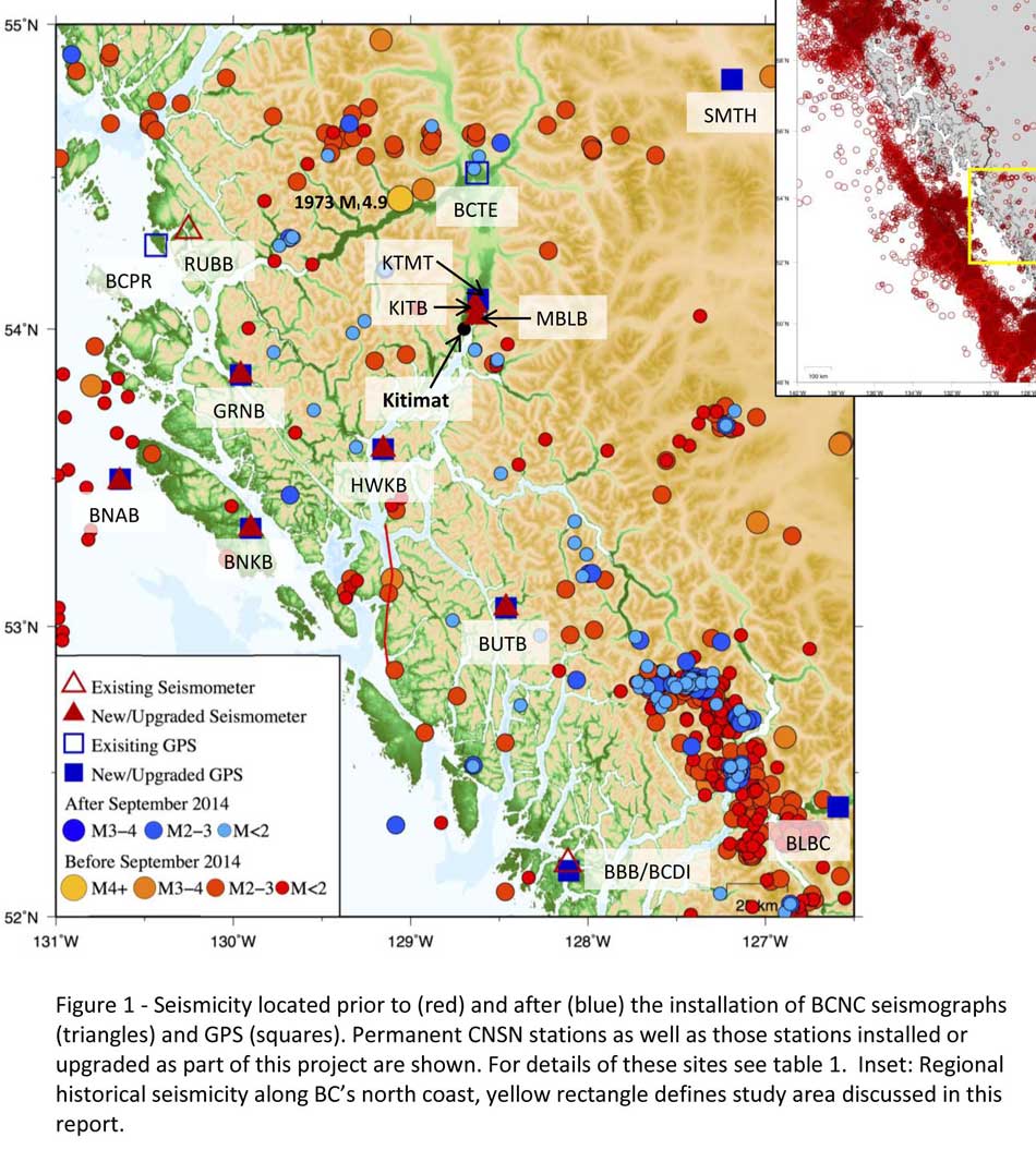
A preliminary seismic hazard assessment by Natural Resources Canada has identified possible earthquake scenarios for the Douglas Channel near Hartley Bay, Terrace and Bella Bella.
The same studies indicate that while Kitimat may not be directly in a seismic zone prolonged earthquakes cause some damage in Kitimat depending on the earthquake and the condition of the soil in certain parts of the District. One model scenario says that in the event of a magnitude 8.0 earthquake off the west coast of Haida Gwaii, given certain soil conditions, there might actually be more damage in Kitimat than on the islands.
Susceptibility to landslides
That assessment, part of the overall the study by the Geological Survey of Canada indicates that the north coast of British Columbia from Prince Rupert to Bella Bella is likely face to “seismically induced ground failure”– mostly landslides.
Overall, the report says that on a scale of 1 to 6 (6 representing the highest
susceptibility), the majority of the west coast of BC “exhibits landslide susceptibility values of 5 to 6, which is significantly higher than the rest of Canada.”
Geological Survey of Canada map showing parts of Canada that are prone to landslides. The BC North Coast study area is outlined by the rectangle. (Geological Survey of Canada)
In British Columbia the landslides are most likely to be triggered by delayed melting of the annual snow pack, heavy rains, bank erosion and site loading and caused long-lasting damning of the river causing “damage to pipelines, rail, and forestry, as well as fish habitats.”
So far no recent landslides along the northern British Columbia coast are known to be caused by earthquakes, the reports say “the existence of numerous landslides strengthens the likelihood of seismically induced ground failures… due to the high levels of seismicity….it is expected that the increased likelihood of strong ground shaking (with long durations) will increase the landslide susceptibility.”
New studies
It was only after the 2012 Haida Gwaii earthquake and with what the Geological Survey of Canada calls “a growing number of on-going and planned infrastructure projects, BC’s north coast is emerging as a region of high strategic importance to Canada’s economy,” that studies began in area where “there has been minimal research to understand earthquake hazards.”
Now that studies have begun the Geological Survey has given the region its own new acronym BCNC (BC North Coast). Haida Gwaii is not part of BCNC, although earthquakes on those islands would likely impact the coast.
A Geological Survey of Canada map showing the BC North Coast region with earthquakes identified prior to and during recent studies. (Geological Survey of Canada)
The Geological Survey says that historically “the BCNC has been seismically quiescent.” As a result “seismic monitoring and research related to the BCNC has been minimal.” That meant while larger earthquakes were “felt and recorded,” the configuration of the Canadian National Seismograph Network did not allow earthquakes less than approximately magnitude 2.1 to be monitored in northern BC.
Now the Geological Survey is looking at “long-term, continuous monitoring of micro seismicity, combined with geodetic and paleo seismic techniques” that could be used to study at the possibility of large earthquakes, including a possible fault on the lower Douglas Channel.
Since the studies began in August 2014, the Geological Survey identified 145 earthquakes within the study area, many too small to be felt since they are less than magnitude 2.0. Those earthquakes, however, were picked up by the new and improved instrumentation used by the earthquake monitors.
The two reports one on “seismic hazards” and the second on “geohazards” says five “temporary seismonitors” (download reports from links below) were installed within the BCNC while some older stations were upgraded, saying, “It is expected that these new stations will be aid in locating small earthquakes” that were not previously detected by the existing network. The Geological Survey also installed ground movement monitoring GPS units along the coast.
The use of the term “temporary” raises the question about how much ongoing monitoring is planned.
The study also notes that the current data is not included in the seismic standards in the current National Building Code of Canada, which in turn is based on the Natural Resources Canada Seismic Hazard Map. That may mean that municipalities in the BC North Coast region, in the future, as the seismic studies continue, may have to consider updating building codes, especially in areas of “softer soils” as opposed to harder rock.
“Fault-like structure” on Douglas Channel
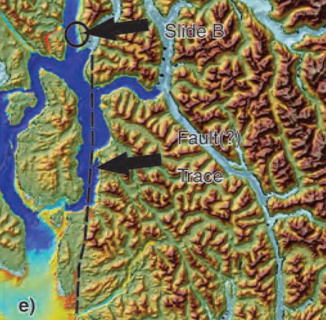
Detail of a map from the Geological Survey of Canada where the red line shows the 60 kilometre possible (still unconfirmed) fault line running from Gribbell Island to Princess Royal Island (Geological Survey of Canada)
Over the years some small earthquakes have also been recorded on what the Geological Survey calls the “recently mapped fault-like structure” on Douglas Channel which was discovered in 2012. The survey is still calling it “fault-like” because it has not yet been confirmed as an active fault. A new map in the study shows that the “fault” runs from the southern tip of Gribbell Island, down the centre of Whale Channel east of Gil Island and then along the western coast of Princess Royal Island.
The study identified “a small, unfelt swarm of earthquakes between magnitude 1.7 and 2.0 between September 13 and 14, 2010 near Gil Island.”
There is also the previously identified ancient Grenville Channel Fault (ancient and believed inactive because it dates from the Cretaceous, the age of the dinosaurs) that runs from along Grenville Channel from Porcher Island in the north to Klemtu in the south which has experienced small earthquakes.
The report says geological studies of the Douglas Channel “fault-like structure” are a priority because, “Should this structure be determined to be an active fault, it would pose significant risk of earthquake-triggered landslides (and subsequent tsunami) from the susceptible Douglas Channel hill slopes.”
Clay and sand in Kitimat
The report also calls for more studies the local geology and soil conditions in the Kitimat Valley. A study back in 1984 by John Clague of Simon Fraser University showed that as the glaciers retreated during the last Ice Age there were “periods of stagnation” resulting in sediments that are thicker than other regions of British Columbia, Clague reported that in parts of Kitimat, the glacial moraine is hundreds of metres thick.
After the glaciers were gone, the sea levels rose and glaciomarine sediments (clay, silt up to 60 metres thick) were deposited until the sea level fell to present-day levels. The report says that as these marine deposits were exposed to fresh water, salts were leached out resulting in saturated, porous sediments, including clay, which are prone to failure. Boreholes in the Kitimat area show that the clay and sediments above the bedrock can range from 17 metres to 106 metres.
The report notes the presence of clay soils “can amplify ground shaking and secondary effects” as happened in November 1988 when there was an earthquake in the Saguenay region of Quebec.
Originally reported as a 6.2 magnitude but later downgraded to 5.9, on Nov. 25, 1988, the major earthquake was centered near the Quebec cities of Chicoutimi and Jonquière, with aftershocks felt as far away as Toronto, Halifax and Boston. The quake lasted for two minutes, catching thousands of people off guard and leaving buildings damaged and power out for hundreds of thousands of Quebecers.
The report says the most significant event within the BC North Coast study region (which as mentioned doesn’t include Haida Gwaii) was a magnitude 4.9 earthquake approximately 20 kilometers southwest of Terrace on November 5, 1973, which was felt as far as 120 kilometers away, with some minor damage (broken windows and cracked plaster) reported near the epicentre. The main shock at Terrace was preceded by a magnitude 2.5 foreshock four hours before, and followed by a felt magnitude 3.7 aftershock the next day.
Bella Bella at risk
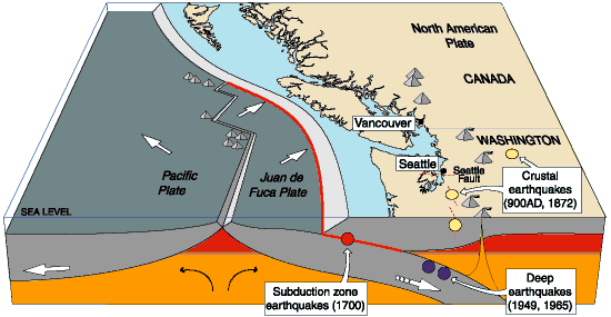
Another area most at risk, according to the report, is southern part of the BC North Coast zone, near Bella Bella, which is close to the northern section Cascadia Subduction Zone a “1,000 kilometre long dipping fault that stretches from Northern Vancouver Island to Cape Mendocino California” which one day will cause a major earthquake along the fault.
Cascadia subduction zone (USGS)
The report says that a magnitude 9.0 or higher earthquake in the northern Cascadia Subduction zone close to Bella Bella would be similar to the March 2011 earthquake in Japan and the 1964 Good Friday earthquake in Alaska.
For the northern part of the BC North Coast region, hazards could come from either a major earthquake off Haida Gwaii or a similar earthquake in south-eastern Alaska.
The greatest hazard would come from “long period” earthquakes greater than magnitude 6.75 with an epicentre between 300 and 350 kilometers away where the shaking lasts longer than one second.
The Geological Survey modeled three possible scenarios for major earthquakes in the BC North Coast Region.
Model #1. A magnitude 8.0 Earthquake at Haida Gwaii
The Geological Survey Canada model for an 8.0 magnitude earthquake west of Haida Gwaii. The possible damage is colour coded in the table below the map according to the Modified Mercalli Intensity Scale. The red polygon represents the area of possible rupture in the model with the star representing the epicentre. (Geological Survey of Canada)
The model looked at a “plausible maximum predicted” magnitude 8.0 thrust fault earthquake off the west coast of Haida Gwaii which would be twice as strong in the fault area as the 7.8 quake on October 28, 2012 (Remember Magnitudes are based on a logarithmic scale. That means for each whole number higher, the amplitude of the ground motion recorded by a seismograph goes up ten times so magnitude 8 earthquake would result in ten times the ground shaking as a magnitude 7 earthquake)
For a short period earthquake, the report estimates that there would be minimal damage on Haida Gwaii similar to the damage from the 2012 earthquake with little or no damage on the BC North Coast.
A long duration, long period earthquake that lasted longer than one second and up to three seconds or longer “may effect taller structures and trigger ground failure (that is liquefaction and lateral shaking).” Kitimat would feel that earthquake with the worst shaking in parts of the District with what the report calls “sensitive soils.” Coastal islands would feel double the amount of shaking as would occur in Kitimat.
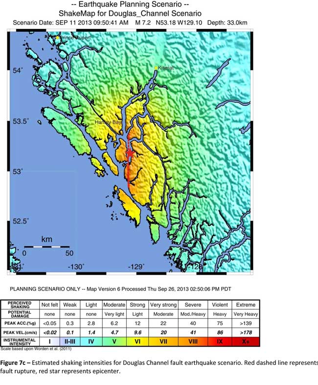
Model #2. A magnitude 7.2 Earthquake in Douglas Channel
The Geological Survey Canada model for a 7/2 magnitude earthquake in the lower Douglas Channel. The possible damage is colour coded in the table below the map according to the Modified Mercalli Intensity Scale. The red star represents the possible epicentre. (Geological Survey of Canada)
The second model looked at an earthquake in Douglas Channel based on the “fault like structure” if a slip strike rupture occurred along the entire 60 kilometers of the so far unconfirmed fault, resulting in a 7.2 magnitude earthquake. There would be very strong shaking within 20 kilometers radius of the epicentre, with moderate to heavy damage” in the relatively uninhabited islands, major shaking in Hartley Bay, resulting in very strong to strong damage at Hartley Bay and strong to moderate damage in Kitimat.
That earthquake, however, would be felt across the entire province of British Columbia. The report notes:
The expected effects and impacts of such an earthquake would mimic those of the 1946 magnitude 7.3 Vancouver Island earthquake, which occurred slightly west of Courtney and Campbell River. Shaking due to the 1946 earthquake was felt as far as Prince Rupert, BC to the north and Portland, Oregon to the south. In addition to knocking down 75 per cent of the chimneys in the local area, much of the earthquake-related damage was due to landslides, slumping and liquefaction
Model #3 A magnitude 6.3 Earthquake near Terrace
The Geological Survey Canada model for an 6.3 magnitude earthquake southwest of Terrace. The possible damage is colour coded in the table below the map according to the Modified Mercalli Intensity Scale. The red polygon represents the area of possible rupture in the model with the star representing the epicentre. (Geological Survey of Canada)
On May 11, 1973, a magnitude 4.7 shallow earthquake took place about 20 kilometers south west of Terrace, on the south side of the Skeena roughly across from the Shames mountain area. The earthquake was felt up to 120 kilometers away. The report says “The event has not been associated with any geologic features in the area and little is known about its rupture process.” The model estimated the results of a larger earthquake 6.3 magnitude in the same area. The model showed there would be strong to very strong shaking in Terrace, light to moderate shaking in Kitimat and light damage elsewhere in the BC North Coast. Most of the damage would be concentrated in a 20 kilometer zone around the epicentre.
The cause of the two failures is still unknown but the report says “their proximity to a nearby unmapped fault-like structure suggests that the slides could have been triggered by strong ground shaking from rupture along this structure.”
Another factor was the two well-known landslides occurred in the 1970’s in the Kitimat Arm which generated tsunamis but fortunately they occurred at low tide which decreased the impact. On October 17, 1974 a submarine slide generated a 2.8 metre tsunami. The following year on April 27, 1975, a slope failure on the northeast side of Kitimat Arm (which overlapped the 1974 failure area) displaced an estimated upper limit of 26,000,000 cubic metres of material.
“Watermark observations in Kitamaat Village estimated that the tsunami generated by this slide was up to 8.2 metres high.” The report says that while the trigger of the first event is unknown; the latter event coincided with nearby construction at that time. Modelling of the 1975 slide estimates that given the right conditions the generated tsunami waves could have been as high as 11 metres.
The report also notes that numerous landslides have also been mapped by the BC Department of Forestry in an attempt to improve safety measures for forestry workers.
The report says “The culmination of these studies brings awareness to the significant natural hazards present in the fragile coastal environment of the Coast Ranges.”
Another factor is the geology of the BC coast. The granitic mountains have rugged, steep slopes dissected by an intricate fjord system and dotted with islands of lower elevation. At lower elevations the land is covered by wet, coastal hemlock forests, which could be vulnerable to ground failures whereas higher elevations are characterized by barren rock or mountain hemlock subalpine.
Table of Seismic monitoring and GPS stations in northern BC from the Geological Survey of Canada (Geological Survey of Canada)
The District of Kitimat said it has “not directly studied these issues but we are aware of potential hazards.” The development department has been advised of potential issues and site concerns.
A spokesperson for Terrace mayor Carol Leclerc told Northwest Coast Energy News in an e-mail. “I have reviewed it and distributed it to the relevant department heads. We are aware that historically Terrace has been at risk for experiencing seismic activity due to its location.”
The District of Kitimat did cooperate with National Resources in finding a location for their recently installed seismic equipment.
At Harley Bay, Gitga’at First Nation CEO Ellen Torng said the Gitga’at have been “ working with NRCan on their research in the Douglas Channel and in Hawksbury. NRC has been meeting with First Nations along the coast and have conducted community sessions on their research.
“We hosted one community session here in Hartley Bay and have regular updates from their technical team when they are in the area,” Torng said.
In addition, the District of Kitimat told Northwest Coast Energy News that Community Planning & Development department also provided local land information to geoscientists in the years leading up an international study called Batholiths on land in 2009.
Batholiths are large zones of molten rock that have solidified in the earth’s crust and are believed to play a key role in the formation and growth of continents. The Coast Mountain Range has a large concentration of batholiths, which means Kitimat was an excellent place to study the earth’s crust.
The project, which involved more than 50 scientists from nine Canadian and American universities, was set up to examine how mountain belts form and change over time and why continental mountain ranges are made of granite not basalt. Seismic imaging of the crust and mantle below the mountains required deploying thousands of seismic sensors and recorders, and recorded responses to several man-made detonations. Field work was completed in July 2009, and several scientific papers and dissertations have followed.
The Heiltsuk Nation was unable to respond to a request for comment due to the ongoing crisis from the sinking of the tug Nathan E. Stewart and the resulting spill of diesel fuel and other contaminants near Bella Bella.
Not felt except by a very few under especially favorable conditions.
II
Weak
Felt only by a few persons at rest,especially on upper floors of buildings.
III
Weak
Felt quite noticeably by persons indoors, especially on upper floors of buildings. Many people do not recognize it as an earthquake. Standing motor cars may rock slightly. Vibrations similar to the passing of a truck. Duration estimated.
IV
Light
Felt indoors by many, outdoors by few during the day. At night, some awakened. Dishes, windows, doors disturbed; walls make cracking sound. Sensation like heavy truck striking building. Standing motor cars rocked noticeably.
V
Moderate
Felt by nearly everyone; many awakened. Some dishes, windows broken. Unstable objects overturned. Pendulum clocks may stop.
VI
Strong
Felt by all, many frightened. Some heavy furniture moved; a few instances of fallen plaster. Damage slight.
VII
Very strong
Damage negligible in buildings of good design and construction; slight to moderate in well-built ordinary structures; considerable damage in poorly built or badly designed structures; some chimneys broken.
VIII
Severe
Damage slight in specially designed structures; considerable damage in ordinary substantial buildings with partial collapse. Damage great in poorly built structures. Fall of chimneys, factory stacks, columns, monuments, walls. Heavy furniture overturned.
IX
Violent
Damage considerable in specially designed structures; well-designed frame structures thrown out of plumb. Damage great in substantial buildings, with partial collapse. Buildings shifted off foundations.
X
Extreme
Some well-built wooden structures destroyed; most masonry and frame structures destroyed with foundations. Rails bent.
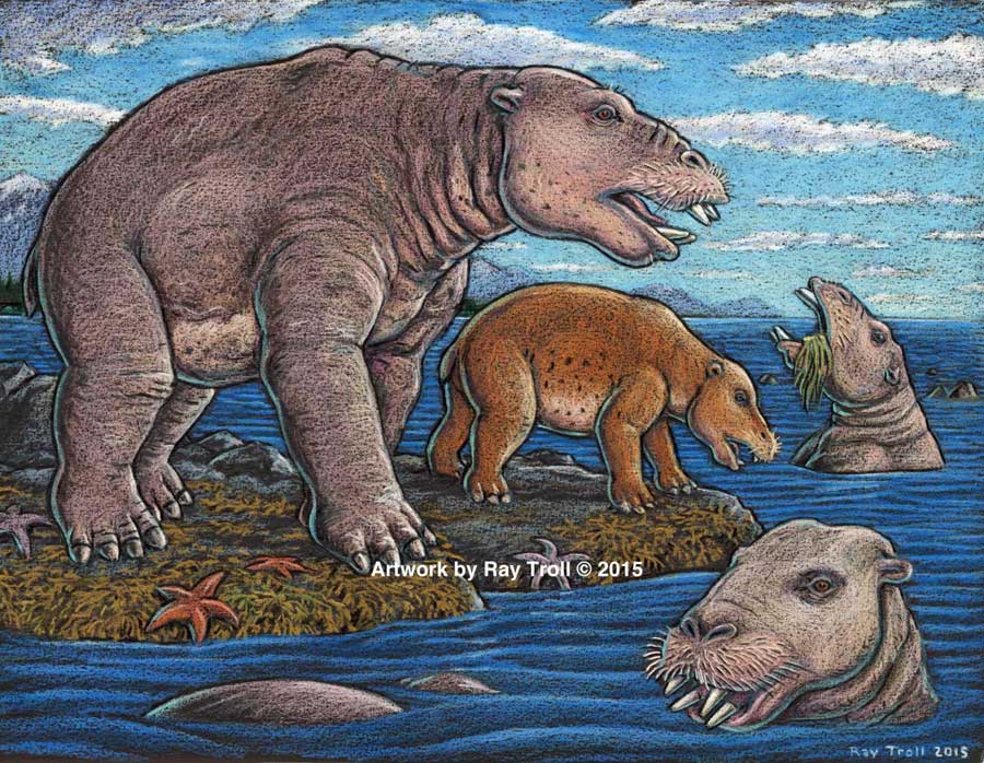
Scientists have identified a new species of a strange marine mammal group that lived on the Pacific Coast between 33 million years ago and 10 million years ago. The new specimens — from at least four individuals — were recovered from Unalaska, in theAleutians.
The Desmostylians, unlike other marine mammals species alive today — such as whales, seals and sea cows –are extinct. The researchers call them “desmos” for short. Unlike whales and seals, but like manatees, desmos were vegetarians
The desmos are found from Baja, California, up along the west coast of North America, around the Alaska Peninsula, the storm-battered Aleutian Islands, to Russia’s Kamchatka Peninsula and Sakhalin Island, to the Japanese islands
Their strange columnar teeth and odd style of eating don’t occur in any other mammal. They rooted around coastlines, ripping up vegetation, such as marine algae, sea grass and other near-shore plants.
The new species, 23 million years old was a big, hippo-sized animal with a long snout and tusks, It has a unique tooth and jaw structure that indicates it was not only a vegetarian, but literally sucked vegetation from shorelines like a vacuum cleaner, said vertebrate paleontologist and study co-author Louis L. Jacobs, Southern Methodist University, Dallas.
They probably swam like polar bears, using their strong front limbs to power along. On land, they would have had the lumbering gait of a sloth.
A large, stocky-limbed mammal, desmos’ modern relatives remain a mystery. Scientists have previously linked the animals perhaps to manatees, horses or elephants. Adult desmostylians were large enough to be relatively safe from predators.
The identification of a new species belonging to Desmostylia has intensified the rare animal’s brief mysterious journey through prehistoric time, according to the new study.
While alive, the newly discovered creatures lived in what is now Unalaska’s Dutch Harbor.
“The new animal — when compared to one of a different species from Japan — made us realize that desmos do not chew like any other animal,” said Jacobs, a professor of earth sciences. “They clench their teeth, root up plants and suck them in.”
To eat, the animals buttressed their lower jaw with their teeth against the upper jaw, and used the powerful muscles that attached there, along with the shape of the roof of their mouth, to suction-feed vegetation from coastal bottoms. Big muscles in the neck would help to power their tusks, and big muscles in the throat would help with suction.
Discovery of the new genus and species that resembled a hippo and swam like a bear, from Unalaska indicates the desmostylian group was a successful group that was larger and more diverse than previously known. (Artist: Ray Troll)
“No other mammal eats like that,” Jacobs said. “The enamel rings on the teeth show wear and polish, but they don’t reveal consistent patterns related to habitual chewing motions.”
The new specimens also represent a new genus — meaning desmostylians in the same family diverged from one anoher in key physical characteristics, particularly the tooth and jaw structure, said Jacobs, who is one of 10 scientists collaborating on the research.
Discovery of a new genus and species indicates the desmostylian group was larger and more diverse than previously known, said paleontologist and co-author Anthony Fiorillo, vice president of research and collections and chief curator at the Perot Museum of Nature and Science, Dallas, and an adjunct research professor at SMU.
“Our new study shows that though this group of strange and extinct mammals was short-lived, it was a successful group with greater biodiversity than had been previously realized,” Fiorillo said.
Compared to other mammals, desmos were latecomers and didn’t appear on earth until fairly recently — 33 million years ago. Also unusual for mammals, they survived a mere 23 million years, dying out 10 million years ago.
The research was funded by the Perot Museum of Nature and Science, U.S. National Park Service – Alaska Region Office, and SMU’s Institute for the Study of Earth and Man.
The newest desmo made its home on Unalaska Island, the farthest north of any occurrence of the group, which only lived along the shores of the North Pacific.
“That’s the only place they’re known in the world,” Jacobs said. The Unalaska fossils represent at least four individuals, and one is a baby.
“The baby tells us they had a breeding population up there,” Jacobs said. “They must have stayed in sheltered areas to protect the young from surf and currents.”
In addition, “the baby also tells us that this area along the Alaska coast was biologically productive enough to make it a good place for raising a family,” said Fiorillo.
Just as cattle assemble in a herd, and a group of fish is a school, multiple desmostylians constitute a “troll” — a designation selected by Jacobs to honor Alaskan Ray Troll, the artist who has depicted desmos most.
The first Unalaska fossils were discovered in the 1950s in a rock quarry during U.S. Geological Survey mapping.
Others found more recently were on display at the Ounalashka Corporation headquarters. Those specimens were offered to Fiorillo and Jacobs for study after Fiorillo gave a public presentation to the community on his work in Alaska.
“The fruits of that lecture were that it started the networking with the community, which in turn led us to a small, but very important collection of fossils that had been unearthed in the town when they built a school a few years earlier,” Fiorillo said. “The fossils were shipped to the Perot Museum of Nature and Science for preparation in our lab and those fossils are the basis for our work now.”
From there, the researchers discovered that the fossils were a new genus and species.
The authors report their discoveries in a special volume of the international paleobiology journal, Historical Biology. The article published online Oct. 1 at http://bit.ly/1PQAHZJ
The researchers named the new mammal Ounalashkastylus tomidai. “Ounalashka,” means “near the peninsula” in the Aleut language of the indigenous people of the Aleutian Islands.
“Stylus” is from the Latin for “column” and refers to the shape of cusps in the teeth.
“Tomida” honors distinguished Japanese vertebrate paleontologist Yukimitsu Tomida.
The article appears in a special volume of Historical Biology to honor the career accomplishments of Tomida upon his retirement from the Department of Geology and Paleontology in Tokyo’s National Museum of Nature and Science.
In addition to Jacobs, Fiorillo and Polcyn, other authors were Yosuke Nishida, SMU; Yuri Kimura, Smithsonian Institution and the Tokyo Museum; Kentaro Chiba, University of Toronto; Yoshitsugu Kobayashi, Hokkaido University Museum, Naoki Kohno, National Museum of Nature and Science; and Kohei Tanaka, University of Calgary.
The Historical Biology article is titled “A new desmostylian mammal from Unalaska (USA) and the robust Sanjussen jaw from Hokkaido (Japan), with comments on feeding in derived desmostylids” and appears in the special issue “Contributions to vertebrate palaeontology in honour of Yukimitsu Tomida.”
Three studies of the geology of Douglas Channel are near completion and publication, according to Natural Resources Canada. That news comes as studies, released today, warn of a major megathrust earthquake on the fault west of Haida Gwaii.
Northwest Coast Energy News asked the Geological Survey of Canada if there were any recent updates available after the agency said that a survey had located a “possible fault” on Hawkesbury Island during studies for the Enbridge Northern Gateway Joint Review Panel.
Natural Resources Canada responded with a statement: “NRCan continues to conduct research studies in the area, including study of possible faults. Three scientific expeditions have been completed on board Coast Guard research ships. The first two reports are in the final stages of editing, and will be published in the coming months. The third expedition was just completed; therefore the third report will be available later.”
More recently there were slope failures nearer to Kitimat. The first slope failure occurred on October 17, 1974, triggering a 2.4 metre tsunami at low tide. Then on April 27, 1975 there was a second slope failure near low tide on the northeast slope of the Kitimat Arm that generated an 8.2 metre tsunami. The 1975 tsunami destroyed the Northland Navigation dock near Kitimat and damaged the Haisla First Nation docks at Kitamaat Village.
Thomas James, of the Geological Survey told Northwest Coast Energy news about the team’s finding on the Haida Gwaii earthquake: “The studies focused on the Haida Gwaii and Craig earthquakes which happened at the Pacific and North American plate boundary, west of Haida Gwaii, so east of Haida Gwaii there’s no comparable plate boundaries that gives rise of historic sieismisticity.”
As well as the fact that recent studies say the mainland margin coastal zone has had very little historical seismicity, it adds no currently active faults have been identified. A study ten years ago identified some very ancient faults which have not been active since the Eocene, about 33 to 56 million years ago.
GPS studies show that in northwestern British Columbia coastal block is moving northeast at the rate of just 5 millimetres a year.
Kitimat Emergency Coordinator Bob McLeod at the earthquake postmortem Oct. 29, 2012 (Robin Rowland/Northwest Coast Energy News)
Studies of the October 2012 magnitude 7.8 Haida Gwaii earthquake show that the region is vulnerable to a “major megathrust” earthquake along a newly confirmed fault line west of the islands.
That earthquake was felt in Kitimat and Kitamaat Village and a tsunami warning was issued within a few minutes.
So have the District of Kitimat, the Haisla Nation Council or Rio Tinto Alcan changed or upgrading their earthquake and tsunami plans in the past couple of years?
Bob McLeod, who recently retired as the District of Kitimat’s emergency coordinator, told Northwest Coast Energy News: “I think we’ve done quite a bit. One of the biggest issues in the first one was trying to get information out. We’ve come a long way on that. Whether you reach everyone or not, that’s another thing, because you never reach everybody. One of the critical things to me is getting the information out so you avoid all this Facebook, Twitter speculating and rumour. The communications aspect has improved a hundred fold.
“We did more work on the mapping and planning. Over the course of the last year, there were a lot of meetings with industry and various stakeholders, discussing emergency preparedness in general but touching on some of these other things as well.
“One of the things we did was to try to set up some shelter points. We have an agreement with the Baptist Church, the Catholic Church and the Seventh Day Adventists. They’re strategically located and could be gathering points for the various neighborhoods if necessary.
“We’ve also done quite a lot of work on Riverlodge as a group lodging centre, thinking in terms of an earthquake where there may be damage and you have to move people.
“We did look at the evacuation planning and we’ve had a couple of exercises involving that, looking strategically about how can you move people from certain neighborhoods, asking which neighborhoods would be at the most risk if you ended up with a tsunami situation.
As for tsunamis, McLeod said, “From everything we’ve heard and been told, tsunamis in extremely deep water like that is not going to be as dangerous as one in shallower water, but the possibility is still there.
“The thrusts are the killers when it comes to tsunamis, but there is a very good warning system on the tsunamis. We do get very very rapid feedback on the earthquakes.
“The only danger in that regard is if you have a severe earthquake and you have part of a mountain drop into the salt chuck, you’re going to get a massive wave and you’re going to get no warning whatsoever, like the Moon Bay collapse in the seventies.
“The emergency plan is in good shape. We scheduled a number of exercises last year through training programs.
“One of the things I personally push is personal preparedness. I think as a community, we fail greatly at that. That was evident even during the snowstorm. People are not just prepared to look after themselves, it’s unfortunate. You just have to keep chipping away.”
Last week, Northwest Coast Energy News asked Rio Tinto Alcan and the Haisla Nation Council if either could comment on updated earthquake or tsunami response plans. So we have received no answers.
The Northern Gateway Joint Review panel, Kenneth Bateman, Sheila Leggett and Hans Matthews, listen to final arguments in Terrace, June 17, 2013. (Robin Rowland/Northwest Coast Energy News)
Buried deep in the LNG Canada environmental assessment application, a reader will find a key difference in attitude with at least one of the group of companies planning liquified natural gas development in the northwest and Enbridge Northern Gateway.
It’s an earthshaking difference, since it’s all about earthquakes.
The documents filed by LNG Canada with the BC Environmental Assessment Office and the Canadian Environmental Assessment Agency acknowledge that there is a possibility of an earthquake (a one in 2,475 year event) at the LNG terminal site.
Northwestern British Columbia was shaken by two major earthquakes in the months before the Joint Review Panel concluded its hearings in Terrace. Both were far from Kitimat, but felt across the District. On October 27, 2012, there was a magnitude 7.8 earthquake on the Queen Charlotte Fault off Haida Gwaii. That quake triggered a tsunami warning, although the actual tsunami was generally limited to the coast of Haida Gwaii. Both landline and mobile phone service in Kitimat was briefly disrupted by both the quake and overloads on the system. Kitimat was also shaken by the 7.5 magnitude earthquake centered at Craig, Alaska a few weeks later on January 9, 2013.
With the exception of one vague reference in its final argument documents presented to the Joint Review Panel, Enbridge has stubbornly refused to consider any seismic risk to the region.
That was the company’s policy long before the October. 27, 2012 Haida Gwaii earthquake and was Enbridge policy after October 27, 2012.
In a public meeting in Kitimat on September 20, 2011, more than a year before the Haida Gwaii earthquake, John Carruthers, Northern Gateway president, insisted to skeptical questioners at a community forum at Mount Elizabeth Theatre that there was no earthquake danger to the proposed Northern Gateway pipeline and bitumen terminal in Kitimat. One of the questioners, Danny Nunes, of Kitimat, asked could the pipes withstand an earthquake? Carruthers repeated that Kitimat was not in an earthquake zone, that the fault was off Haida Gwaii and so would not affect Kitimat.
After the September, 2011 meeting, I asked Carruthers if Enbridge knew about the March 27,1964 “Good Friday” magnitude 9.2 Alaska earthquake that, because of its high magnitude, had caused major shaking in Kitimat. That earthquake destroyed much of Anchorage and triggered tsunamis that caused damage and death across Alaska and in parts of British Columbia, Oregon and California.
Carruthers promised to get back to me and never did.
On June 17, 2013, six months after the Craig, Alaska earthquake, in his opening summation before the Joint Review Panel, Richard Neufeld, lead lawyer for Northern Gateway, stayed on message track, telling the JRP, referring to pipelines: “The route is not seismically unstable. The seismic risk along the pipeline right-of-way is low, with only a few locations of moderate risk encountered, none of which are within the Haisla territory.”
That brought a gasp from spectators in the room, or at least those who had felt the October and January earthquakes.
The following day, June 18, Murray Minchin of Douglas Channel Watch found an anomaly in the Enbridge documentation, arguing in the group’s summation:
“The Proponent’s written final argument gets on shaky ground regarding design and construction of the storage tanks on a ridge beside Douglas Channel in paragraph 249 where they say:
“‘It also involves the safe construction and operation of the Kitimat terminal in Kitimat Arm in an area subject to seismic activity which encompasses both terrestrial and marine components.’
“Now, that’s interesting because isn’t that the first time — the first admission by the Proponent in a little over 10,000 pages of documents that the area they intend to build their project is in a seismically-active area?
“Haven’t they been telling us all along to this point that the only seismic concerns would be from the distant Queen Charlotte fault off of Haida Gwaii?
“Now, this completely contradicts Mr. Neufeld’s statement yesterday where he described the Project area as not “seismically unstable”. So what is it? This is their final argument and they’re contradicting themselves.”
Minchin went on to quote from the Enbridge argument: “’Seismic conditions in the project area have also been addressed.’
“Well, really? Is that a truthful statement, considering Natural Resources Canada has only submitted a preliminary report concerning a 50-kilometre fault line and massive submarine landslides they accidentally discovered last year in Douglas Channel while doing a modern survey of the Channel for navigation hazards.
“How can the Proponent claim to have adequately addressed seismic forces in their design of this Project when they don’t know what those forces are or for what duration they may be subjected to those forces.
“Has there ever been a paleoseismological study in the Project area to establish past earthquake or tsunami history?
“Wouldn’t it be in the best interest of the Proponent, the Panel and Canadians to know the risks before 1.3 billion litres of liquid petroleum products are allowed to be stored on a low ridge right beside Douglas Channel?”
In his final rebuttal on June 24, Neufeld did not address the contradictions that Minchin had pointed out.
Compare Enbridge’s attitude to the view of LNG Canada, which at very least, appears willing to consider that major events could have adverse consequences on the terminal and liquifaction facilities.
The first one is a bit puzzling to Kitimat residents “A 1 in 100 year 24 hour rain event,” after all the town often gets rain for 24 hours straight or more fairly often.
The second, 1 in 200 year flood of the Kitimat River. Flooding has always been a concern and will be even more so, because as the pipelines come into town, whether natural gas or bitumen, those pipelines will be close to the river bank.
Even more interesting is that LNG Canada is willing to consider possible effects of climate change on the project, saying: “Predicted climate change effects during the project lifecycle on sea-level rise, precipitation and temperature. Where relevant and possible, the implications of such climate induced changes to the extreme weather events given above will also be addressed.”
.
Although the hydrocarbon industry as a whole is reluctant to acknowledge climate change, it appears that on a practical level, the LNG Canada partners, if they are about to invest billions of dollars in a natural gas liquifaction plant and marine terminal, will certainly take steps to protect that specific investment from the effects of climate change.
On the other hand, the National Energy Board, as matter of policy and the Northern Gateway Joint Review Panel, both still stubbornly refuse to even consider any effects of climate change, even possible effects locally on a specific project application.
The Joint Review Panel decision on the Northern Gateway is expected sometime in the next three weeks. While most reports seem to indicate that the decision will be released after Christmas before the Dec. 30 deadline, there has been recent media speculation that the decision could be released next week.
The problem for Enbridge is that the new public relations campaign is repeating the blunders that began when they first proposed Northern Gateway in 2005. There have been meetings across the northwest, but those meetings have been invitation only affairs at chambers of commerce and community advisory boards, with possible opponents or skeptics and media perceived as critical of Enbridge not invited. So Enbridge still wants to control the message and will only talk to friendly gatherings.
Then there are the television spots featuring Janet Holder, the Enbridge vice president in charge of Northern Gateway, supposedly showing her commitment to wilderness. Those commercials would have had more credibility if the agency had produced the ads with actual video of Holder walking through the bush, rather than shooting the spots in front of a green screen in a studio, with pristine wilderness stock video in the background, and Holder acting as if she was a model for an adventure clothing company rather than vice president of a pipeline company.
Right-wing business columnists in Toronto and the countless Albertans fume at the so-called “hypocrisy” of British Columbians who support LNG and oppose bitumen.
Of course, those critics didn’t feel the earth move under their feet. The critics don’t see the difference between natural gas and bitumen, differences very clear to the people of British Columbia.
It’s more than the fact, that so far, the LNG projects have been relatively open and willing to talk to potential adversaries, as Chevron has done on the controversial Clio Bay project; more than the fact that if even a fraction of the LNG projects go ahead, the money coming into northwestern BC means that the handful of permanent jobs promised by Enbridge will be literally a drop in a bucket of warm bitumen.
Although there are many other environmental issues on the Northern Gateway project, the fact the potential for earthquakes in Kitimat is brushed off by Enbridge while LNG Canada is at least willing to consider the problem, sums it all up.
Updated with link to Sept. 2011 questions and answers
Could the future of northwestern British Columbia’s hoped for natural gas boom depend on the outcome of this weekend’s Australian general election?
While the mainstream media in North America has mostly been following the personal feud between Prime Minister Kevin Rudd and Opposition Leader Tony Abbott or speculating whether or not Wikileaks founder Julian Assange’s party will make a ripple or a splish, a natural gas crisis has rocketed high on to the Australian election agenda.
I’ll be the first to admit that I know very little about Aussie politics, but I couldn’t ignore all the LNG and natural gas Australian election related stories that suddenly started showing up in my alerts.
LNG train “on ice”
This morning came the alert that Chevron has put the development of another train at its giant Gorgon LNG facility “on ice” (as a pun enabled headline writer in the Western Australian put it)
Chevron and its partners in the Gorgon LNG project on Barrow Island are expected to postpone work on detailed design and engineering of a fourth processing line at the mega project until at least next year as they battle to contain the soaring cost of the foundation development.
As reported by WestBusiness at the weekend, Chevron’s latest internal cost review is understood to have placed a final cost on Gorgon’s three-train venture of up to $US59 billion ($65.6 billion), or 13 per cent above the last confirmed budget revision of $US52 billion.
Chevron is refusing to discuss the status of the cost review and is understood to have told its Gorgon team to “value engineer” in the hope of substantially reducing the latest overrun on a project that was originally supposed to cost $US37 billion to complete.
Raw logs all over again
For a resident of northwestern BC, one thought comes to mind from the media reports on the LNG situation in the Australian election, it’s raw logs all over again.
It appears from those media reports that while Australia has huge reserves of shale-based natural gas, the way the country has structured its LNG boom, major industries and consumers are becoming alarmed that domestic natural gas prices for both will soon skyrocket. There are calls for whatever party wins the election to pass legislation that would create “domestic gas reservation” so that Australians won’t see the gas exported while they pay higher prices for what’s left over.
Most of the shale gas reserves are in Western Australia, while the population—and industry– are concentrated far away on the east coast.
That is leading to another controversy, demands that eastern Australia develop its coal gas reserves, which, of course, brings to mind Shell’s decision to forgo development of coal gas deposits in the Sacred Headwaters and the ongoing fight by the Tahltan First Nation to stop Fortune Minerals’ open pit coal mine in the Sacred Headwaters at Klappan.
Then there’s another vexing issue that northwestern BC is facing and soon have to deal with. In the election, some Australian politicians and unions are calling for curbs on the use for temporary (and not so temporary) foreign workers.
Another factor is the growing cost of natural gas extraction and LNG export, which has, in the midst of the election campaign, pitted Chevron against Australian unions, with Chevron executives (as they did in other contexts before the election call) pointing to Canada—that means Kitimat, folks — as the cheaper alternative.
Rising prices
The Australian has reported that a poll, commissioned by the nation’s manufacturers, so it is somewhat suspect, that:
Manufacturers will today claim that most Australians want a policy of domestic gas reservation and that this would sway voter intentions, a move set to renew the acrimonious debate over rising gas prices.
Manufacturing Australia will release a survey it commissioned where 35 per cent of people said it was “quite likely” and 13 per cent “extremely likely” that it would sway their decision at the election if a party made a policy pledge on the issue.Those uncertain stood at 21 per cent.
Bob Katter flew through Gladstone as fast as the wind whistled through Spinnaker Park on Monday, where he told local media he wanted to reserve a domestic gas supply for Australia and scrap the 457 visas that bring foreign workers into the country….
Mr Katter said mineral processing was under enormous pressure in Australia with copper processing wiped out in northern Queensland and to counter that, the Katter Australia Party would reserve 1% of the gas supply for Queensland.
“Because of the escalating skyrocketing cost of coal, gas and electricity in the past eight years, one per cent of the gas will be reserved for the benefit of the people in Queensland if not Australia,” he said.
“That gas will be used to produce electricity at prices our retirees can afford, and young families can afford, and most importantly that our mineral processing plants have prices for processing they can afford.”
Coal gas
Another story in The Australianquotes James Baulderstone of the Australian energy company Santos:
THE NSW gas industry has warned of higher gas prices, job cuts and a significant risk to the state’s energy security if the coal-seam gas sector is not developed.
James Baulderstone, vice-president of eastern Australia at Santos, said without indigenous gas of its own, NSW had no ability to control its energy supply security.
“NSW faces prospective gas shortages as long-term contracts underpinning the state’s gas supply expire over the next two to three years, the very time in which the commencement of LNG exports from Queensland will see annual gas demand in eastern Australia triple,” he said.
“Looming natural gas shortages in NSW could be avoided by the timely and balanced development of the state’s already discovered reserves of natural gas.”
Also embroiling the election is the growing dispute between Chevron and the Australian unions. As the Australian Financial Review reported, Chevron is claiming that high costs are slowing the LNG projects and blaming the government of Prime Minister Kevin Rudd.
The federal government has rejected claims from Chevron that Australia’s high-cost economy is threatening the nation’s biggest energy project, Gorgon, even as the Maritime Union of Australia demands a 26 per cent pay rise and more than 100 other benefits for its members, including Qantas Club memberships and iTunes store credits.
As Chevron’s $52 billion Gorgon project became embroiled in the election campaign, trade union officials accused Chevron of seeking to dodge responsibility for poor labour productivity and high costs.
The union’s demands for employees working for 19 offshore oil and gas contractors around Australia include a 26 per cent raise over four years, no foreign labour without consultation, union control of hiring and four weeks holiday for every four weeks work.
(Note there are accusations of biased reporting during this election, especially from the media owned by Rupert Murdoch. I could find no independent confirmation of union demands for airline memberships and iTunes credits)
The Australian Labour minister, Gary Gray, who is from Western Australia, and according to reports, in a tough re-election fight, is blaming Chevron and the other energy companies for “failing to control the costs of their staff and contractors.”
“We do need our companies to get better in managing their productivity issues,” he said.
Prime Minister Kevin Rudd said he had studied China’s latest five-year economic plan and concluded Australia’s industrial relations system wasn’t hurting the industry.
Boom or bust?
The Australian Financial Review quotes Chevron Australia managing director Roy Krzywosinski as saying Australia has a two-year window to get policy settings right and fix industrial relations and productivity or risk losing out on billions of further investment in liquefied natural gas projects.
It goes on to make a reference to Shell and operations in Canada—again that’s Kitimat folks.
after the unprecedented rush of LNG investment in the past four years, Australia has become the most costly place worldwide for new plants, while new competition is emerging in North America and east Africa.
Shell, which has slowed its $20 billion-plus Arrow LNG project in Queensland, said construction costs in Australia are now up to 30 per cent higher than in the US and Canada.
Mr Krzywosinski said LNG projects are “long-term projects that transcend governments” and Chevron would work with all sides of politics to get policy settings right.
The investment surge in LNG – often favourably compared with the Apollo moon program in its magnitude – is in some ways a bubble. Firms have rushed in, extrapolated an endless supply/demand imbalance for their product, ignored global competition, over-paid for assets and developed with little thought to what others were doing, grossly inflating input costs in the process.
The blogger goes on to say
This fallout is typical of the “built it and they will come” attitude that seized energy and mining executives in the final stages of the “commodity super cycle” boom. A similar story, with different dynamics, is playing out in coal and next year in iron ore.
The unions are largely not to blame for the cost blowouts even if they are a party to them. They are, after all, unions. What does capital think will happen if it hands them such a card to play?
Sound familiar? Australia a mirror of the BC election?
Again it appears from this far off shore, that the Australian election is somewhat mirroring the recent BC provincial election and not only because of the issue of LNG. The Labour PM Kevin Rudd returned to power after three years on the back benches, coming back after the party dumped PM Julia Gillard.
Like BC, the Australian Liberal Party is really conservative. The Liberal Leader Tony Abbott, wants to abolish Australia’s carbon tax but Abbott is also threatening to fine companies that don’t lower prices if (or when) the carbon tax is abolished.
The polls show that the Liberal Party is leading, but that Kevin Rudd is more popular than Tony Abbott. Rudd is running an attack campaign against Abbott, warning of the consequences of an (conservative) Liberal victory. Sounds a bit like Christy Clark.
Given the split in the polls, with the leader of one party more popular than the leader of the party that is leading the polls, this video of the editors of The Australian which accompanies this story shows their senior editors are awfully confident, perhaps over confident, about the polls. I know given what happened in BC, Alberta and even Israel, I’d be a lot more skeptical.
We’ll know the outcome of the Australian election by this time next week. As for LNG, given the volatility of the market, who knows?
(Editor’s Note: Tony Abbott and the Australian Liberal Party won a landslide victory in the weekend vote)
(Note some of the Australian media sites appear to be metered and allow only one viewing)
Apache Corporation said Thursday it will sell oil and gas producing properties in the Nevis, North Grant Lands and South Grant Lands areas of western Alberta, to Ember Resources Inc., a private Canadian company, for CAN$220 million, as part of the company’s “portfolio rebalancing,” Apache said in a news release.
At the same time, Apache CEO Rodney Eichler said, “We also remain focused on advancing the Kitimat LNG project to monetize large unconventional resources in the Liard and Horn River basins in northern British Columbia.”
“Going forward, Apache is focused on growing our liquids production from a deep inventory of crude oil- and liquids-rich opportunities that generate attractive rates of return on our extensive remaining acreage in Canada’s Western Sedimentary Basin,” Eichler said.
“This transaction is one element of a comprehensive review of Apache’s portfolio to determine which assets make the most sense for Apache to own given our growth and return objectives and which assets are better owned by others,” Eichler said. “The Nevis, North Grant Lands and South Grant Lands assets fit in the latter category.”
Apache is selling 621,000 gross acres (530,000 net acres) and more than 2,700 wells that had average net production during the second quarter of 2013 of 67 million cubic feet of gas and 237 barrels of liquid hydrocarbons per day from late Cretaceous sands and coal seams. Apache says “it will retain 100 per cent working interest in horizons below the Cretaceous, such as potential Duvernay and Nisku, in Nevis and North Grant Lands.”
Apache previously announced plans to divest $4 billion in assets by the end of 2013. The company intends to use proceeds from the asset divestitures to reduce debt and enhance financial flexibility and to repurchase Apache common shares under a 30-million-share repurchase program authorized by the Board of Directors earlier this year.
In July, Apache announced an agreement to sell its Gulf of Mexico Shelf operations and properties to Fieldwood Energy LLC(Fieldwood), an affiliate of Riverstone Holdings, for cash proceeds of $3.75 billion. In addition, Fieldwood will assume all asset retirement obligations for these properties, which, as of June 30, 2013, Apache estimated at a discounted value of approximately $1.5 billion.
A study by two scholars at Simon Fraser University says that the Enbridge Northern Gateway project is much more hazardous to Kitimat harbour, Douglas Channel and the BC Coast than Enbridge has told the Joint Review Panel.
The study by Dr. Thomas Gunton, director of the School of Resource and Environmental Management at SFU and Phd student Sean Broadbent, released Thursday May 2, 2013 says there are major methodological flaws in the way Enbridge has analyzed the risk of a potential oil spill from the bitumen and condensate tankers that would be loaded (bitumen) or unloaded (condensate) at the proposed terminal at Kitimat.
Enbridge Northern Gateway responded a few hours after the release of the SFU study with a statement of its own attacking the methedology used by the two SFU scholars and also calling into question their motivation since Gunton has worked for Coastal First Nations on their concerns about the tanker traffic.
Combination of events
One crucial factor stands out from the Gunton and Broadbent study (and one which should be confirmed by independent analysis). The two say that Enbridge, in its risk and safety studies for the Northern Gateway project and the associated tanker traffic, consistently failed to consider the possibility of a combination of circumstances that could lead to either a minor or a major incident.
Up until now, critics of the Northern Gateway project have often acknowledged that Enbridge’s risk analysis is robust but has consistently failed to take into consideration the possibilty of human error.
As most accidents and disasters happen not due to one technical event, or a single human error, the SFU finding that Enbridge hasn’t taken into consideration a series of cascading events is a signficant criticism.
Overall the SFU study says there could be a tanker spill every 10 years, not once in 250 years, as calculated by Enbridge.
It also says there could be 776 oil and condensate spills from pipelines over 50 years, not 25 spills over 50 years as projected by Enbridge. (And the life of the project is estimated at just 30 years, raising the question of why the 50 year figure was chosen)
Enbridge track record
The study also bases its analysis of the possibility of a spill not on Enbridge’s estimates before the Joint Review Panel but on the company’s actual track record of pipeline spllls and incidents and concludes that there could be between one and 16 spills (not necessarily major) each year along the Northern Gateway pipeline.
Findings for Kitimat
Among the key findings for Kitimat from the SFU study are:
Enbridge said the possibility of tanker spill was 11.3 to 47.5 per cent over the 30 year life of project. The SFU study says the possibility of a spill within the 30 years is 99.9 per cent.
The SFU study says it is likely there will be a small spill at the Kitimat Enbridge terminal every two years.
The SFU study estimates that there will be eight tanker transits each week on Douglas Channel if the Northern Gateway project goes ahead and more if it is expanded. (This, of course, does not include LNG tankers or regular traffic of bulk carriers and tankers for Rio Tinto Alcan)
The SFU study says that while Endridge did study maneuverability of tankers, it paid little attention to stopping distance required for AfraMax, SuezMax tankers and Very Large Crude Carriers.
The SFU study says Enbridge inflated effectiveness of the proposed tethered tugs and maintains the company did not study ports and operations that use tethered tugs now to see how effective tethering is.
The SFU says Enbridge’s risk analysis covered just 233 nautical miles of the British Columbia coast, where as it should have covered entire tanker route both to Asia and California, raising the possibility of a tanker disaster outside British Columbia that would be tied to the Kitimat operation.
Based on data on tanker traffic in Valdez, Alaska, from 1978 to 2008, the SFU study estimates probability of a 1,000 barrel spill in Douglas Channel at 98.1 per cent and a 10,000 barrel spill at 74.2 per cent over 30 year Gateway life. The Valdez figures account for introduction of double hulls after Exxon Valdez spill in 1989 and notes that spill frequency is much lower since the introduction of double hulled tankers.
According to a study by Worley Parsons for Enbridge in 2012, the Kitimat River is the most likely area affected by an unconstrained rupture due to geohazards in the region. According to the Worley Parsons study, geohazards represent the most significant threat to the Northern Gateway pipeline system.
Flawed studies
The SFU scholars list a series of what they say are major methological or analytic flaws in the information that Enbridge has presented to the Joint Review Panel, concluding that “Enbridge significantly understates the risk of of spills from the Northern Gatway.
Enbridge’s spill risk analysis contains 28 major deficiencies. As a result of these deficiencies, Enbridge underestimates the risk of the ENGP by a significant margin.
Some of the key deficiencies include:
Failure to present the probabilities of spills over the operating life of the ENGP
Failure to evaluate spill risks outside the narrowly defined BC study area
Reliance on LRFP data that significantly underreport tanker incidents by between 38 and 96%.
Failure to include the expansion capacity shipment volumes in the analysis
Failure to provide confidence ranges of the estimates
Failure to provide adequate sensitivity analysis
Failure to justify the impact of proposed mitigation measures on spill likelihood
Potential double counting of mitigation measures
Failure to provide an overall estimate of spill likelihood for the entire ENGP
Failure to disclose information and data supporting key assumptions that were used to reduce spill risk estimates
Failure to use other well accepted risk models such as the US OSRA model
SFU reports that Enbridge provides separate estimates of the likelihood of spills for each of the three major components of the project:
tanker operations,
terminal operations,
the oil and condensate pipelines.
The SFU scholars say Enbridge does not combine the separate estimates to provide an overall estimate of the probability of spills for the entire project and therefore does not provide sufficient information to determine the likelihood of adverse environmental effects……
It notes that “forecasting spill risk is challenging due to the many variables impacting risk and the uncertainties in forecasting future developments affecting risk. To improve the accuracy of risk assessment, international best practices have been developed.”
Part of the problem for Enbridge may be that when the company appeared before the Joint Review Panel it has repeatedly said that will complete studies long after approval (if the project is approved), leaving large gaps in any risk analysis.
The SFU study may have one example of this when it says Enbridge did not complete any sensitivity analysis for condensate spills at Kitimat Terminal or the condensate pipeline.
Our experts have identified a number of omissions, flawed assumptions and modeling errors in the study and have serious concerns with its conclusions:
The spill probability numbers are inflated: The author uses oil throughput volumes that are nearly 40 per cent higher than those applied for in this project which also inflates the number of tanker transits using these inflated volumes
The pipeline failure frequency methodology adopted by Mr. Gunton is flawed, and does not approximate what would be deemed a best practices approach to the scientific risk analysis of a modern pipeline system
Mr. Gunton based his failure frequency analysis on a small subset of historical failure incident data. Why would he limit the source of his data to two pipelines with incidents not reflective of the industry experience and not reflective of the new technology proposed for Northern Gateway?
The study results are not borne out by real world tanker spill statistics. Based on Mr. Gunton’s estimates we should expect 21 to 77 large tanker spills every year worldwide while in reality after 2000 it has been below 3 per year and in 2012 there were zero.
Most of Enbridge’s rebuttal is a personal attack on Gunton, noting
We are very concerned about the misleading report released by Mr. Gunton, who was a witness for the Coastal First Nations organization during the Northern Gateway Joint Review Panel process.
Mr. Gunton should have made his study available to the JRP process, the most thorough review of a pipeline that’s ever taken place in Canada. All of Northern Gateway’s conclusions have been subject to peer review, information requests and questioning by intervenors and the Joint Review Panel.
In response, Gunton told the Globe and Mail “the report took over a year to complete and it was not ready in time to be submitted as evidence before the federal Joint Review Panel which is now examining the proposed pipeline.”
Enbridge’s statement also ignores the fact under the arcane rules of evidence, any study such as the one from Simon Fraser had to be submitted to the JRP early in the process, while evidence was still being submitted.
The recent ruling by the JRP for closing arguments also precludes anyone using material that was not entered into evidence during the actual hearings.
That means that the SFU study will be ignored in the final round of the Joint Review Panel, which can only increase the disillusionment and distrust of the process that is already common throughout northwest British Columbia.
 As related in Gordon Robinson’s Tales of the Kitamaat, the First Peoples living on the coast of what is now British Columbia ventured up what is now called Douglas Channel perhaps from either Bella Bella in Heiltsuk traditional territory or from Prince Rupert in Tsimshian traditional territory.