THE RIVERBANK PAPERS: After the flash flood on September 11, 2017, Northwest Coast Energy News filed Freedom of Information/Access to Information requests with a number of provincial and federal agencies who have jurisdiction over the Kitimat river and riverbank camping. The first response to the FOI request is from the Ministry of Forest, Lands and Natural Resource Operations & Rural Development.
A preliminary assessment by the British Columbia Ministry of Forest, Lands and Natural Resource Operations & Rural Development indicates that the District of Kitimat can regulate access to camping on the Kitimat River bank because although the shoreline is on Crown Land, the camping area is within the boundaries of the District.
One of the possible policies that the District staff is considering is allowing only “day access” to the riverbank.
An email on October 11, from Liz Williamson, a senior policy analyst in the ministry’s Land Tenure Branch to Gwen Sewell, the District’s Director of Planning and Community Development, reads:
Permission does not apply to Crown Land within a municipality—as a result even in the absence of zoning/bylaws, any camping that does occur is technically in non-compliance with the permission and therefore could be subject to enforcement action under the Land Act.
Williamson notes that the province likely will have to be involved.
Ultimately that does rely on provincial resources and it looks like DOK would want a greater role in the use and ability to locally enforce the use as you have mentioned zoning and associated bylaws would likely be a course of action you could consider.
Williamson went on to write:
I’m waiting to hear back from one of my more experienced colleagues but I am not aware of any specific limitation to DOK creating bylaws to regulate public recreational use of vacant Provincial land within the municipal boundaries, so long as it doesn’t conflict with a government interest.
She added that the laws and regulations are complex and advised the District to get legal advice. Then she added the District should have “upfront discussions with appropriate provincial authority to ensure that the bylaws do not conflict with existing policy/legislation or other agency interests.”
Right after the flash flood both Sewell and District of Kitimat Chief Administrative Officer, Warren Waycheshen, exchanged emails with officials of both the Ministry of Lands and Forests and the Ministry of the Environment asking first if the province would have any objections to a proposed plan to put gates on municipal land to limit access to the riverbank. Council later put the gate plan on hold.
The emails quoted provincial land use permission policy that says
“Crown permission to use land requires the activity must abide by and comply with all applicable, regulations and bylaws.
And
Before any person may rely on the Permission they must ensure that the activity is taking place on unencumbered Crown land. The Crown land must not be within
A Protected Area includes Ecological Reserves, Parks and Conservancies
Municipality
In his email to Cam Bentley, Resource Manager for the Skeena Lands district, Waycheshen asked if the province was interested in some form of joint administration of the riverbank and if the ministry was interested in joining the working group.
Sewell sent a similar email to Williamson noting,
Camping has been occupying the banks of the Kitimat River—opposite a municipal campground called Radley Park—for decades….This had been a somewhat divisive local issue (it’s no cost and traditional use, grey water, residual garbage, human waste, blocking river access for day users etc. and there is a new willingness to consider regulation or prohibition of camping following a flash flood that required a dangerous multi-force rescue effort to save 14 campers and resulted in significant property loss (RVs, vehicles and camping equipment). As camping is “unregulated” the first responders had no idea how many people were in danger or where to look for campers.
Sewell went on to say:
Given…municipal authority to regulate land use by zoning, I believe Kitimat Council may use their zoning power to limit all or selected land along the Kitimat River to “day use only.” I am far from certain this will be the course of action Council will choose to pursue. For now, we only want to identify possibilities.
Williamson replied to Sewell saying that it was good there was no loss of life in the flood. She noted the Keremeos had been going through a similar situation but that village’s problem was that, unlike the District of Kitimat, the camping was outside the municipal boundaries of the village.
KEEP THE RIVERBANK PAPERS INVESTIGATION GOING.
These days filing Freedom of Information and Access to Information requests is much more expensive than it was in the past. It is part of obstruction of freedom of information by all levels of government. One agency wants $900 for their files on the Kitimat River camping issue. That is currently under appeal. Donations (see right hand column) will help the residents of Kitimat know more about what is happening on the camping issue.
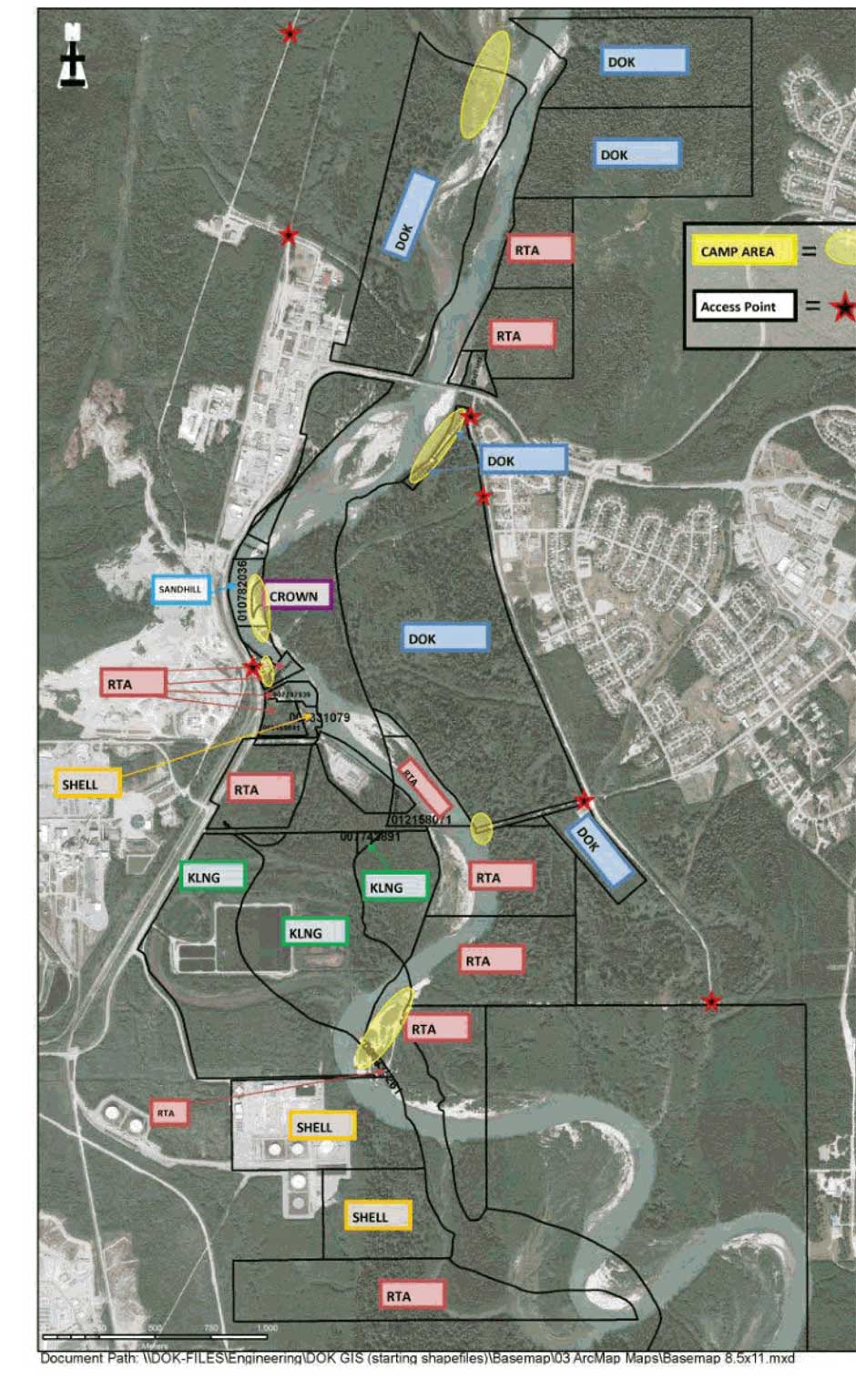
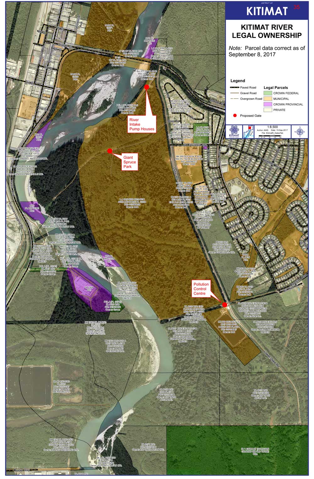
Map showing the various jurisdictions along the Kitimat River that the District submitted to the province (District of Kitimat via BC FOI)
As related in Gordon Robinson’s Tales of the Kitamaat, the First Peoples living on the coast of what is now British Columbia ventured up what is now called Douglas Channel perhaps from either Bella Bella in Heiltsuk traditional territory or from Prince Rupert in Tsimshian traditional territory.
The young men on the expedition up the Kitimat Arm spotted what they thought was a huge monster kilometres ahead with a large mouth that was constantly opening and closing. The sight was so terrifying that the men fled back to their homes and dubbed the Kitimat Arm as a place of a monster.
Later a man named Hunclee-qualas accidentally killed his wife and had to flee from the vengeance of his father-in-law. Knowing he had to find a place where no one could find him, he ventured further up the Kitimat Arm. There he discovered that the “monster” was nothing more than seabirds, probably seagulls, perhaps feasting on a spring oolichan run.
He settled along the shore of what is now the Kitimat River and found a land of plenty, with fish, seals, game as well as berries and other natural products of the land. Eventually he invited others to join him, which began the Haisla Nation and he became their first chief.
Let’s examine the new evidence so far.
Settlement along the coastal “kelp highway” between 18,000 and 16,000 years ago, followed by a warm spell 14,500 years ago
It’s now fairly certain that the First Peoples first began to settle along the coast by following the “kelp highway” perhaps as early as 18,000 years ago and certainly by 14,000 years ago. Haida Gwaii was ice free, except for some mountain glaciation as early as 16,500 years ago. At about 14,500 years ago there was a warming spell which forced the glaciers to retreat, brought higher sea levels and the arctic like tundra ecosystem would have been replaced, at least for a time, by forests. There is the discovery of a Heiltsuk settlement dated to 14,000 years ago. At that time almost all of the coast would have been free of glacial ice but there were still glaciers in the fjords, including the Kitimat Arm which would mean there could be no permanent settlement in the “inland coast” and the interior.
(Science)
The cooling period from 14,000 to 11,700 years ago confines settlement to the coast
The cooling periods (with occasional warmer times) from about 14,000 years ago to about 11,700 years ago meant that settlement would largely have been confined to the coast for about two and half millennia. The culture of the coastal First Peoples would have been well established by the time the glaciers began the final retreat.
(Remember that it is just 2,000 years from our time in 2017 back to the height of the Roman Empire under Augustus Caesar).
It is likely that the cooling periods also meant that some descendants of initial settlers likely headed south for relatively warmer climates. Rising sea levels meant that the initial settlement villages would likely have been abandoned for higher ground.
A second period of rapid warming 11,700 years ago which opens up the interior fjords and valleys
At the end of what geologists call the Younger Dryas period, about 11,500 years ago, the climate warmed, the glaciers retreated further, in the case of Kitimat, first to what is now called Haisla Hill, then to Onion Flats and finally to Terrace.
Large glacial sediment river deltas filled with fresh melt water from retreating ice
The most important confirmation of the story of Hunclee-qualas’s exile is the account of the monster, the birds and the oolichan run.
The new scientific evidence, combined with earlier studies, points to the fact that the glacial melt water carried with it huge amounts of glacial sediment that created vast river deltas in coastal regions of the Northern Hemisphere.
That means around 10,000 years ago, when the Kitimat Valley was ice free and the new forest ecosystem was spreading up the valley, the Kitimat River estuary was likely to have been much larger than today. It could have been a vast delta, which would have quickly been repopulated with fish, including salmon and oolichan. That rich delta ecosystem could have supported a much larger population of seabirds than the smaller estuary in recent recorded history.
Snow geese by the thousands in the Sacramento-San Joaquin Bay Delta/ CrunchySkies/Wikimedia Commons/Creative Commons License
The story of the monster those first travelers saw far off is highly plausible. Even today in huge, rich deltas elsewhere in the world, seeing hundreds of thousands of birds in flight over a wetland is fairly common. (For a description of what a Kitimat River delta may have been like thousands of years ago, see KCET’s story on the Sacramento-San Joaquin Bay Delta and what that delta was like 6,000 years ago)
The First Peoples had had well established communities for up to four thousand years before the Kitimat Valley’s metres of thick ice had melted away. For the first period, while the ecosystem regenerated, for the people of the coast coming up Douglas Channel to the valley would not have been worth it, there would be little to find in terms of fish, game or forest resources.
A Snow Goose flock near the Skagit River Delta, WA./ Walter Siegmund/Wikimedia Commons
The change from tundra to a rich forest environment
Eventually as the forest regenerated, the streams filled with salmon and oolichan; the bird population including gulls, geese and eagles, found a new feeding ground; bears, deer and other animals arrived. The Kitimat region would have been an attractive place to explore and hunt. It may be the monster story did keep people away until Hunclee-qualas had to find a place to hide and discovered a new home just at a time that might be called an ecological optimum with new forests stretching back along the valley to what is now Terrace.
The river delta shrinks back to the current estuary
If a vast Kitimat River delta did stretch further down the Channel than it does in 2017, it likely shrank back in the subsequent millennia. Eventually the mass of glacial sediment that came downstream after the retreat of the ice would diminish, but not stop entirely. The estuary is still rebuilt from sediments washed downstream but that sediment doesn’t match other rich deltas elsewhere such as the Nile in Egypt. With that regeneration of the delta slower and smaller than in the first centuries of Haisla settlement, at the same time the land surface rebounded from the weight of the ice, perhaps creating the Kildala neighborhood. The ocean level rose, drowning and eroding part of the old delta, creating the estuary we know today.
As the authors of the paper on the First Peoples’ settlement note, most of the archaeological evidence of early coastal settlement is now likely many metres below the surface of the ocean but deep ocean exploration may uncover that evidence. As the scientific team on the second paper say, they are now working on detailed studies of the glacial retreat from the coastal mountain region which may, when the studies are complete, change the timeline
While waiting for further evidence from archaeology and geology it is safe to say that the stories of the monster and later Hunclee-qualas’s discovery of the Haisla homeland are even more compelling than when Gordon Robinson wrote Tales of the Kitamaat. We can now speculate that there was once, stretching from Haisla Hill far down the Channel, a vast, varied rich, river estuarine delta that supported hundreds of thousands of seabirds, which if they took the wing in unison, would have made those unwary travelers millennia ago, really think that there was a giant monster waiting to devour them at the head of the Kitimat Arm.
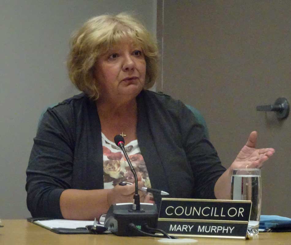
District of Kitimat Council voted Monday five to two to create a “working group” of “concerned citizens and community groups” to consider the future of riverbank camping along the Kitimat river. The working group will consider issues such as access to the river, pollution and how to control extended camping along the river.
That vote came after council split five to two again to defeat a motion by Councillor Mary Murphy to stop riverside camping altogether.
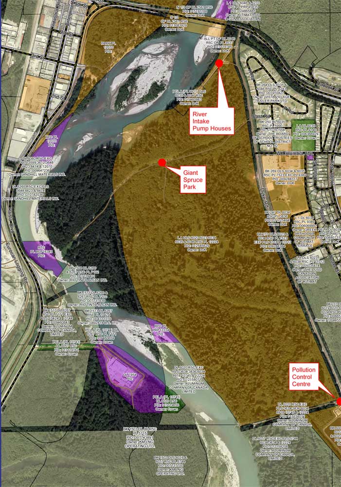
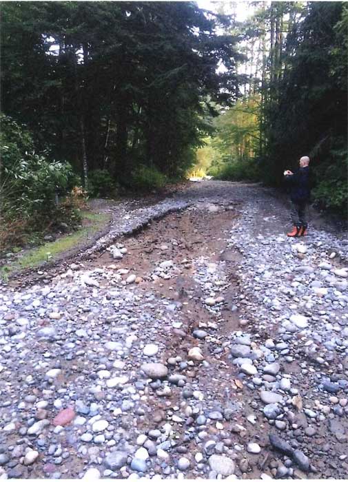
A proposal from District staff to put access gates at three locations, the Giant Spruce Road, the Sewage Plant and the Pump House was tabled for the time being. However, the councilors and staff marked the pump house gate as a priority for study by the engineering staff due to concerns that “the risk of fuel, oil and other contaminants (i.e. Illegal dumping ) occurring. This is the source water area for the city’s water supply, reducing access reduces contamination risks.” Staff said that unlike other portions of the riverbank, the District does “have authority under drinking water protection act to protect this area.”
Council also voted to close Hirsh Creek park immediately because the roads at the camping area were washed out by the flood last week.
Councillors noted that many people still go to Hirsch Creek after the gates are closed at the end of the season to walk dogs or hike. This results in a parking jam at the front of the gate and on busy times, cars park on Highway 37 which could endanger pedestrians.
District staff will study moving the park gate down further to a point that the road narrows near the first campsite to allow safe access for dog walkers and hikers.
The main problem facing the District of Kitimat is that most popular sites along the riverbank for campers are on provincially owned Crown land. In 2014, the former BC Liberal government passed a regulation that says people can camp on Crown land for up to 14 days. As some councillors pointed out this restriction regularly abused by some campers who stay on the riverbank for weeks, some apparently camping from Victoria Day to Labour Day.
A detail from the DoK map of who owns the riverbank shows that many of the popular camping sports along the Kitimat River are on provincial Crown land (dark green) while the municipality controls the land away from the riverbank including the access roads (brown). (District of Kitimat)
During the debate it was pointed out that often those camp on the riverbank like to “claim” a camping/fishing spot and try to prevent others from using it. “I know of a couple of fistfights,” Murphy told Council.
As Councillor Rob Goffinet pointed out, whether or not the District could place gates on municipal land to stop access to provincial Crown land would require a legal opinion.
Murphy told Council that she had received emails, blaming Kitimat for “almost drowning” some of the campers. She said that her views may be unpopular among some residents, but added, “I don’t care if I’m unpopular, I want to keep people safe.”
Councillor Larry Walker, who pointed out that he likes of fish along the river, who supported Murphy’s motion told his colleagues to get their act together and “do something about the riverbank.” He later proposed that if council does nothing, perhaps Kitimat should hold a referendum on the future use of the river bank.
The majority on Council were more cautious, while acknowledging problems. They pointed out that the many of the campers both on the east bank and on the west bank at Radley Park patronize local businesses during the summer months.
While there was wide discussion on social media before the council meeting, only three people showed up to give their opinions, mostly concerned about permitting access to the river for people with mobility issues or small children.
There were many comments and questions about how other areas police provincial Crown Land, with some saying that some places restrict access to only a couple of days. However, no one either on Council or staff had any idea of what exactly other locations are doing, if anything.
There were no details of how the working group would operate and who would participate. During the debate it was pointed out that as well as the province, participants would have to include Rio Tinto, LNG Canada and DFO. As well, Council did not set a deadline for the working group to report back.
As Murphy pointed out back in 2014, Fisheries and Oceans refused to attend a Council meeting or make a public presentations on its views of the river bank situation. (DFO snubs District of Kitimat Council for a second time ) while offering to meet with staff “they will continue to meet at an operational level to provide information on DFO’s regulatory role.” That, of course came during the Stephen Harper administration which severely restricted any public participation by the civil service on environmental issues. Whether the Justin Trudeau government has changed that policy remains to be seen.
The campsite road at Hirsch Creek park was washed out in the flood. (District of Kitimat)
Was the rain storm an anomoly?
During the debate, Mayor Phil Germuth, pointed to the sudden onslaught of rain during Sunday and Monday September 10 and 11 and called it “an anomaly” which means that Kitimat should not overreact to the storm.
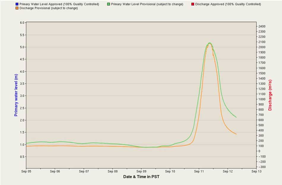
Environment Canada chart of the spike in the Kitimat River levels, as presented to District Council. (Environment Canada)
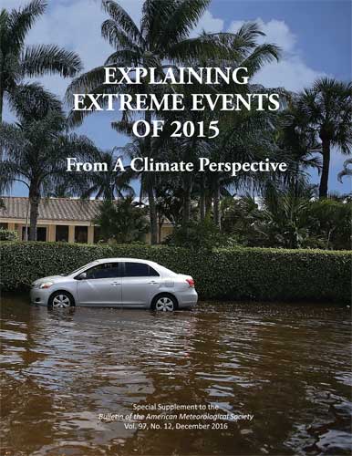
Climate science has repeatedly shown that global warming is increasing the odds of extreme precipitation and storm surge flooding. Refusing to acknowledge this impairs our ability to prepare for future extreme weather and endangers American lives and property.
Scientists can now even evaluate how much climate change has increased the odds of individual extreme events, including rainfall and flooding.
As the 2015 American Meteorological Society report quoted by The Times indicates, those unpredictable and extreme events don’t just include floods but the widespread forest fires in Alaska in 2014 and we all know how bad the fire season has been in British Columbia this year.
As Noah Diffenbaugh of Standford University pointed out in The Times
Being smart about managing exposure and vulnerability is critical to reducing risks. But doing so requires acknowledging that global warming is happening, that humans are the primary cause and that the odds of catastrophes like Hurricane Harvey are increasing.
The District of Kitimat has issued a map clarifying just who owns the banks of the Kitimat River, a subject that has been debated for years, as campers have come and gone as they please.
The map issued by the District staff shows that the District of Kitimat has jurisdiction over much of the land on the east side of the river while Rio Tinto owns much of the western bank–but also does own some of the eastern bank in the lower levels.
District staff are recommending that gates be installed in three areas along the eastern bank on municipally owned land, at the Giant Spruce Road, at the Pump House and at the Sewage plant. That could cut off vehicular traffic while still allowing access for pedestrians and those who wish to fish on the river bank by getting access on foot.
The proposed locations of the gates are marked in red on the map.
Map showing who owns the riverbank lands with the proposed gates marked by red dots. (District of Kitimat)
You’ll find a larger version of the map, and staffs’ recommendations to District Council in the report.
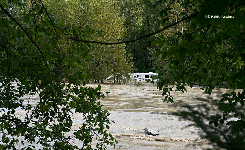
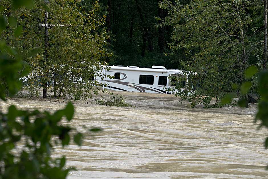
Heavy rain and strong winds combined with high tide overnight Sunday, September 11 flooded out fishers and campers along the Kitimat River.
The RCMP say twelve people were rescued via boat and two by helicopter, mostly along the Big Spruce bank. The RCMP say all are currently accounted for, although police say they will have to check the riverbanks once the water levels drop in about 48 hours.
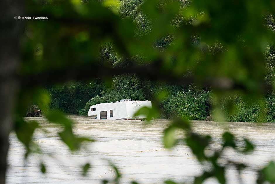
Another view of the RV that was swept into the river. (Robin Rowland/Northwest Coast Energy News)
Kitimat Search and Rescue, Kitimat Fire and Rescue, RCMP and Terrace Swift Water Rescue participated in the operation.
The RCMP is asking the public to contact them about concerns about people who may be overdue or possibly missing at 205-632-7111.
A large recreational vehicle is surrounded by swift water on the Kitimat River, Sept. 11, 2017. (Robin Rowland/Northwest Coast Energy News)
It is estimated that the river quickly rose about four metres. The rising water made it impossible for some people to retreat to the Dyke Road.
The first calls for help came to RCMP about 2 am Monday, with more around 3:30 am and the rescue began at first light about five hours later.
Environment Canada issued a heavy rainfall warning at noon on Sunday, calling for at least 66 millimetres of rain. It appears that some of the campers were either not aware of the warning or thought they could ride out the storm.
Perhaps as many as a dozen recreational vehicles were flooded or swept into the river, along with a pickup truck and a small car.
Some of those who were evacuated from the riverbanks were sheltered at the Riverlodge Recreation Centre.
Environmental and fisheries officials will be checking for any pollution in the river once conditions are safe.
The District of Kitimat is warning people to stay away from the riverbanks since the swift water can quickly destablize the soil along the river. The District has closed Radley Park and Hirsh Creek parks for the remainder of the season. The Dyke Road and Big Spruce roads are also closed.
The Environmental Protection Division of BC’s Ministry of Environment is launching a major study of the water quality in the Kitimat valley, first on the Kitimat River and some of its tributaries and later on the Kitimat Arm of Douglas Channel.
There has been no regular sampling by the province in Kitimat since 1995 (while other organizations such as the District of Kitimat have been sampling).
Jessica Penno, from the regional operations branch in Smithers, held a meeting for stakeholders at Riverlodge on Monday night. Among those attending the meeting were representatives of the District of Kitimat, the Haisla Nation Council, LNG Canada, Kitimat LNG, Rio Tinto BC Operations, Douglas Channel Watch, Kitimat Valley Naturalists and the Steelhead Society.
As the project ramps up during the spring and summer, the ministry will be looking for volunteers to take water samples to assist the study. The volunteers will be trained to take the samples and monitored to insure “sample integrity.” Penno also asked the District, the Haisla and the industries in the valley to collect extra samples for the provincial study and to consider sharing historical data for the study.
With the growing possibility of new industrial development in the Kitimat valley, monitoring water quality is a “high priority” for the province, Penno told the meeting. However, so far, there is no money targeted specifically for the project, she said.
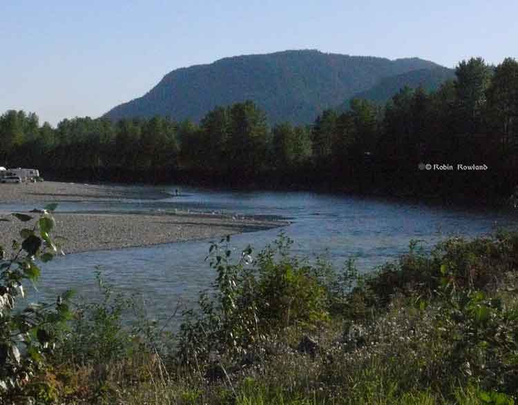
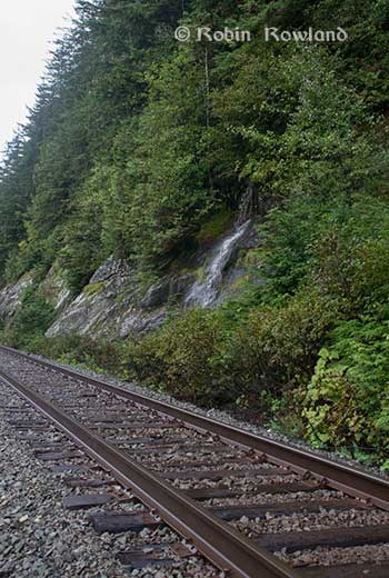
Camping and fishing on the Kitimat River. (Robin Rowland/Northwest Coast Energy News)
The purpose of the study is to make sure water in the Kitimat valley meet the provinces water quality objectives, which have the aim of watching for degradation of water quality, upgrade existing water quality or protect for designated uses such as drinking water, wildlife use, recreational use and industrial water supplies as well as protecting the most sensitive areas. It also provides a baseline for current and future environmental assessment. (In most cases, testing water quality for drinking water is the responsibility of the municipalities, Penno said. The province may warn a municipality if it detects potential problems, for example if a landslide increases metal content in a stream).
Under the BC Environment system, “water quality guidelines” are generic, while “water quality objectives” are site specific.
One of the aims is to compile all the studies done of the Kitimat River estuary by the various environmental impact studies done by industrial proponents.
The ministry would then create a monitoring program that could be effectively shared with all stakeholders.
At one point one member of the audience said he was “somewhat mystified” at the role of Fisheries and Oceans in any monitoring, noting that “when you phone them, nobody answers.”
“You mean, you too?” one of the BC officials quipped as the room laughed.
Water quality objectives
The last time water quality objectives were identified for the Kitimat River and arm were in the late 1980s, Penno told the meeting. The objectives were developed by the British Columbia government because of potential conflict between fisheries and industry at that time. The objectives were developed for the last ten kilometres of the Kitimat River and the immediate area around the estuary and the Kitimat Arm. “The Kitimat is one of the most heavily sport fished rivers in Canada,” she said.
However, the work at that time was only provisional and there was not enough water quality monitoring to create objectives that could be approved by the assistant deputy minister.
There has been no monitoring of the Kitimat River by BC Environment since 1995. “We’ve had a lot of changes in the Kitimat region, with the closure of Methanex and Eurocan, the modernization of Rio Tinto and potential LNG facilities.”
The main designated uses for the Kitimat River at that time were aquatic life, wildlife with secondary use for fishing and recreation.
She said she wants the stakeholders to identify areas that should be monitored at first on the river and the tributaries. Later in the summer, Environment BC will ask for suggestions for the estuaries of the Upper Kitimat Arm.
Participants expressed concern that the water supply to Kitamaat Village and the Kitimat LNG site at Bish Cove as well as Hirsch Creek and other tributaries should be included in the study. Penno replied that the purpose of the meeting was to identify “intimate local knowledge” to help the study proceed.
After a decade so of cuts, the government has “only so much capacity,” Penno said, which is why the study needs the help of both Kitimat residents and industry to both design the study and to do some of the sampling.
The original sampling station in the 1980s was at the Haisla Boulevard Bridge in Kitimat. A new sampling station has been added at the “orange” Kitimat River bridge on Highway 37. There is also regular sampling and monitoring at Hirsch Creek. The aim is to add new sampling points at both upstream and downstream from discharge points on the river.
The people at the meeting emphasized the program should take into consideration the Kitimat River and all its tributaries—if budget permits.
Spring freshette
Last year, the team collected five samples in thirty days in during four weeks in May and the first week in June, “catching the rising river quite perfectly” at previously established locations, at the Haisla Bridge and upstream and downstream from the old Eurocan site as well as the new “orange bridge” on the Kitimat River.
The plan calls for five samples in thirty days during the spring freshette and the fall rain and monthly sampling in between.
The stakeholders in the meeting told the enviroment staff that the Kitimat Valley has two spring freshettes, the first in March during the valley melt and later in May during the high mountain melt.
The plan calls for continued discussions with the industry stakeholders, Kitimat residents and the Haisla Nation.
The staff also wants the industrial stakeholders to provide data to the province, some of it going back to the founding of Kitimat if a way can be found to make sure all the data is compatible. One of the industry representatives pointed out, however, that sometimes data is the hands of contractors and the hiring company may not have full control over that data.
There will be another public meeting in the summer, once plans for sampling in the Kitimat Arm are ready.
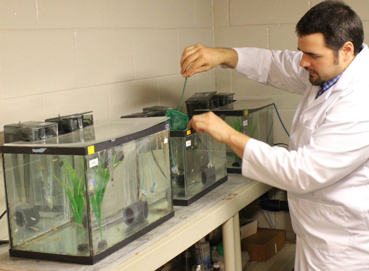
Diluted bitumen, also known as dilbit, a mixture of oil sands bitumen and natural gas dilutants can seriously harm fish populations, according to research study at Queen’s University and the Royal Military College of Canada published this week.
At toxic concentrations, effects of dilbit on exposed fish included deformities and clear signs of genetic and physiological stress at hatch, plus abnormal or uninflated swim bladders, an internal gas-filled organ that allows fish to control their buoyancy. Exposure to dilbit reduces their rate of survival by impairing their ability to feed and to avoid predators.
Post-doctoral fellow Barry Madison works with the fish in Valerie Langlois’ lab. (Queen’s University)
Among the other findings from the study were
Embryo toxicity of dilbit was comparable to that of conventional oils.
Developmental malformations increased with increasing dilbit concentrations.
Chemical dispersion broadened the genotoxic effects of dilbit
“This new study provides a clearer perspective on the potential risks to Canada’s aquatic resources of dilbit spills, and a technical basis for decisions on dilbit transportation within Canada,” says Peter Hodson Environment Studies, Biology at Queens. “It reduces some of the uncertainty and unknowns about the hazards of dilbit.”
This study characterized the toxicity and physiological effects of unweathered diluted bitumen (Access Western Blend dilbit; AWB) to a fish used for laboratory studies. Embryos of Japanese medaka (Oryzias latipes) were exposed for 17 days to dilutions of dilbit physically-dispersed by water and chemically-dispersed by dispersants
AWB dilbit exposure was not lethal to medaka, but resulted in a high prevalence of blue sac disease (BSD), impaired development, and abnormal or un-inflated swim bladders. Blue sac is a disease of young trout and other salmonid species; usually caused by unsuitable hatchery water. It turns the yolk sac bluish and is thought to be caused by a lack of oxygen.
The research was funded by Fisheries and Oceans Canada’s National Contaminants Advisory Group and the next stage will determine whether fish species native to Canada will be affected by dilbit exposure. The work also includes the development of genetic markers of exposure to dilbit and toxicity that could be used to assess whether wild fish that survive a spill are still affected.
The research team includes Dr. Valérie Langlois (Environmental Studies, Royal Military College of Canada) and Dr. Barry Madison (Royal Military College of Canada).
Dr. Hodson is also a member of a Queen’s research team tasked to determine whether dilbit spilled into rivers would contaminate bed sediments, specifically areas where fish such as salmon, trout, chars, whitefish and graylings spawn, to the extent that the survival of their embryos would be affected.
The research was published in ScienceDirect and is one of the first studies of dilbit on young fish.
The finding could be significant because both the proposed Northern Gateway pipeline and the proposed Kinder Morgan expansion will cross areas near spawning streams.
There’s a dumb, dumb, really dumb idea that just won’t go away—that Enbridge could solve all its problems if only, if only, it would send the Northern Gateway Pipeline to Prince Rupert.
Enbridge long ago rejected the idea. Before Enbridge updated its website to make Gateway Facts, to make it slick and more attractive, the old website had an FAQ where Enbridge explained why it wasn’t going to Prince Rupert.
Did you consider running the pipeline to Prince Rupert where a major port already exists?
We considered Prince Rupert and Kitimat as possible locations. We carried out a feasibility study that took into account a number of considerations. The study found that the routes to Prince Rupert were too steep to safely run the pipeline, and that Kitimat was the best and safest option available.
Current proposed route for the Northern Gateway pipeline. (Enbridge)
Here in the northwest even the supporters of the Northern Gateway roll their eyes when they hear the old Prince Rupert story come up again and again – and it’s not just because these people support the Kitimat plans for Northern Gateway, it’s because those supporters (not to mention the opponents) have driven along the Skeena from Terrace to Prince Rupert.
There just isn’t any room for a pipeline. It’s a game of centimetres.
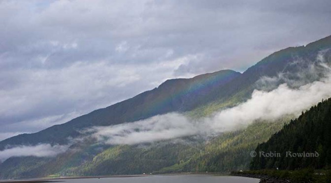
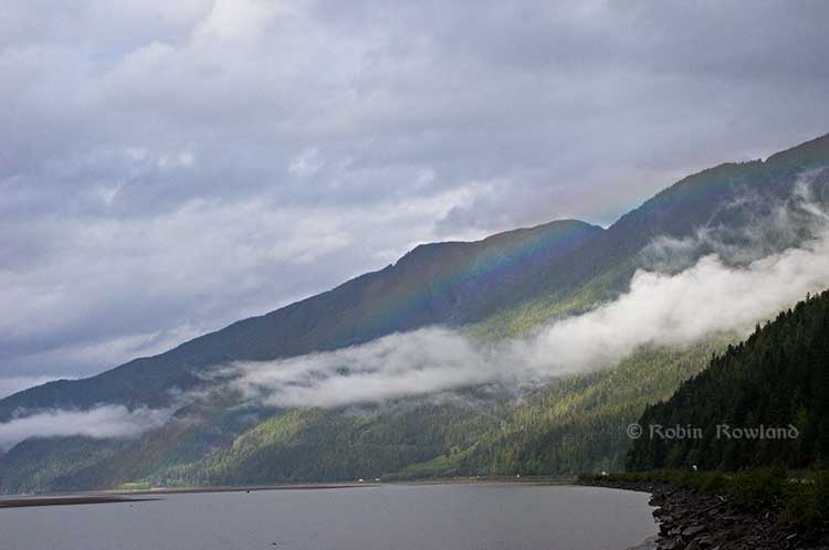
A rainbow hugs the mountains near the Telegraph Point rest area on the Skeena River between Terrace and Prince Rupert, Sept. 29, 2014. Traffic is seen on the narrow corridor between the mountains and the river (Robin Rowland/Northwest Coast Energy News)
Alternatives to Kitimat?
Now the new premier of Alberta, Jim Prentice, who should know better if he’s going to lead that province, is hinting that Kitimat isn’t the only possible solution for the Northern Gateway.
Without specifying Prince Rupert, according to Gary Mason reporting in The Globe and Mail, Prentice was speculating about an alternative to Kitimat.
Asked whether he believes the Gateway terminus should be relocated to Prince Rupert or another destination, Mr. Prentice said, “Everything I’ve heard from the Haisla who live there is they don’t agree with the terminal being in Kitimat.” Is it possible to get First Nations approval if there is no support at the planned terminus site? “It’s pretty tough,” the Premier said.
Prince Rupert has a thriving local fishing industry that employs hundreds of people and is critically important to the local First Nations. He is convinced the community would not be willing to put that at risk.
“Overwhelmingly people in my community are much more comfortable with liquefied natural gas, with wood pellets, with coal, than any oil product,” he said.
The Prince Rupert Port Authority also rejected the idea
A spokesman for the Prince Rupert Port Authority said Wednesday there is currently no room for Enbridge to build at the port even if it wanted to. “We are fully subscribed,” Michael Gurney said. There are two large vacant lots within the port authority’s jurisdiction, but both are locked by other energy companies, earmarked for LNG projects.
So not only is there no room on the road to Prince Rupert, there is no room in Prince Rupert.
Shovel-ready?
Let’s just consider for a moment that if Prince Rupert was the ideal location for the Northern Gateway terminal (which it is not), what would be needed to get the project going today.
The Northern Gateway Joint Review Panel would have be reconstituted or a new JRP created by the National Energy Board. That’s because the bitumen comes from Bruderheim, Alberta, crossing provincial boundaries and thus it’s in federal jurisdiction.
Even under the fast track rules imposed on the NEB by Stephen Harper’s Conservative government, new environmental and social impact studies would be required, starting from scratch. So add another five years of paperwork before a single shovel goes into the ground.
The pipeline would have to cross the traditional territory of First Nations that, so far, have not been part of the negotiations, mostly the Tsimshian First Nation as well as the Nisga’a First Nation which has a treaty establishing local rule over their territory.
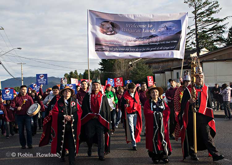
Traditional leaders of the Gitga’at First Nation lead a protest march through the streets of Prince Rupert, February 4, 2012. (Robin Rowland/Northwest Coast Energy News)
In February 2012, the largest anti-Enbridge demonstration outside of the Lower Mainland took place in Prince Rupert, with the elders of the Tsimshian First Nation welcoming the elders and members of the Gitga’at First Nation, at Hartley Bay, which had organized the protest.
When I say there isn’t room for a pipeline along the Skeena, it also means that there isn’t any room for the pipeline corridor right-of-way. Enbridge, in its submissions to the Joint Review Panel, said it requires a 25 metre wide right of way for the pipeline corridor. (For the record that’s just over 82 feet).
Along that highway, as you will see, there’s barely enough room for the CN mainline and Highway 16 (also known as the Yellowhead Highway) and on a lot of places both the highway and the railway roadbed are built on fill along the side of a cliff.
Albertans’ desperate desire to see the Northern Gateway go to anywhere to what they call “tide water” keeps coming up like the proverbial bad penny. The latest came when Jim Prentice speculated about a new route for the Northern Gateway.
I knew I had an appointment coming up in Prince Rupert on Monday, September 29. So I decided that only way to prove to people sitting in Calgary, Edmonton and Fort McMurray playing with Google Maps that the pipeline to Prince Rupert was a really dumb idea was to shoot photographs to show just why the Northern Gateway will never go to Prince Rupert—at least along the Skeena.
As you drive out of Terrace, you pass two large swing gates (also called by some “Checkpoint Charlie” gates after the Cold War era crossing in Berlin.) At the first rest stop west of Terrace, there are another set of gates at the Exstew. There’s a third set of gates just outside Prince Rupert.
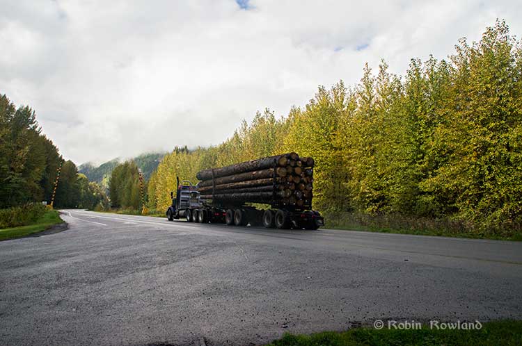
A logging truck passes the avalanche gates at Exstew on Highway 16, Sept. 29, 2014. (Robin Rowland)
The swing gates are avalanche gates and, in the winter, Highway 16 can be shut down if an avalanche closes the highway or the danger from avalanche is too great to allow motorists to proceed. When you drive the highway from Terrace to Prince Rupert in the winter (the signs were covered up when I drove Monday) you are warned “Avalanche danger Next 13 kilometres. No stopping.”
The Exstew avalanche gates, (Robin Rowland/Northwest Coast Energy News)
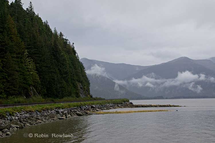
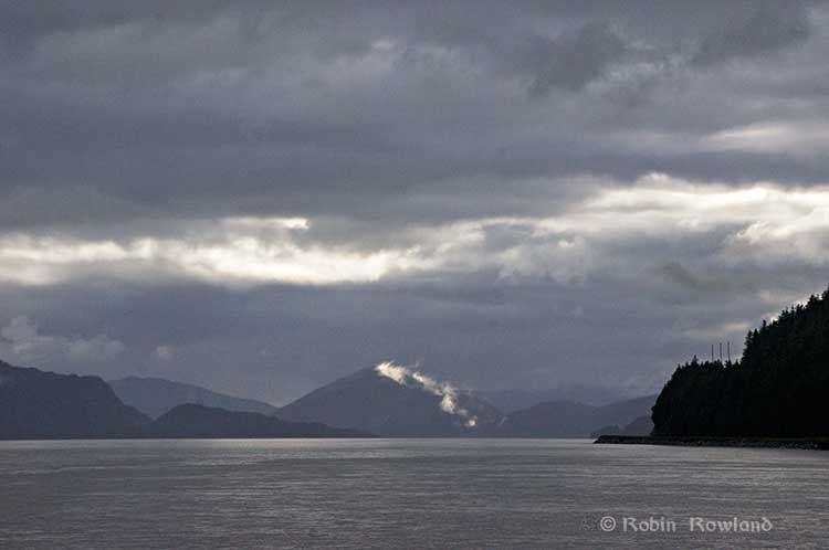
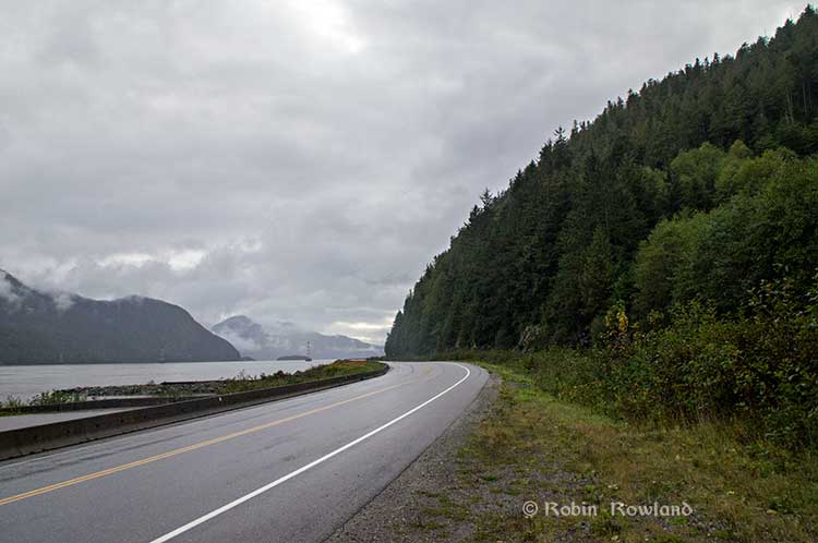
The drive along the Skeena from just west of Exchamsiks River Provincial Park all the way to Tyee where the highway turns inland to reach northwest to Prince Rupert on Kaien Island is one of the most spectacular drives on this planet. The highway snakes along a narrow strip of land with steep mountain cliffs on one side and the vast river on the other.
The problem is that apart from locals and tourists, none of the “experts” whether journalist, think tanker, bureaucrat or politician have, apparently ever driven from Prince Rupert to Terrace.
When both Opposition Leader Tom Mulcair and Liberal Leader Justin Trudeau were in the northwest earlier this summer to “engage” with the local people, apart from short boat trips down Douglas Channel, they flew everywhere. Scheduling you know. Stephen Harper has never visited northwest BC and probably never intends to. His cabinet members fly in for photo ops and then are on the next plane out of town.
Of all the visiting journalists who have come to the northwest only a couple have bothered to drive around the region. Most fly-in fly-out. These days, most often budget-strapped reporters never leave their offices, interviewing the same usual suspects by phone on every story.
On Monday, I took most of the photographs on my way back from Prince Rupert to Terrace after my appointment, so the sequence is from west to east. There are also very few places along the river where you can safely stop. There are concrete barricades on both sides of the highway to prevent vehicles either going into the river or onto the narrow CN right-of-way.
There are, however, two rest stops and a number of small turnoffs on the highway, the turnoffs mainly intended for use by BC Highways, but which are also used by tourists, fishers and photographers.
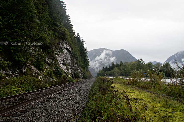
The first image was taken at one of those highway turnoffs just east of Aberdeen Creek. This is what the highway and rail corridor are like all along the Skeena, the highway, bounded by concrete barricades, the CN rail line and then the towering mountains. Note where the telegraph and telephone lines are—further up the cliffside.
A closer view of the highway and rail corridor just east of Aberdeen Creek.
Here is the view of the Skeena River from the Aberdeen Creek turnoff. You can see to the east, a mountain and the narrow strip of fill land that supports the highway and the rail line.
You see the broad width of the mighty Skeena, the Misty River, as it is called by the Tsimshian First Nation and by everyone else who lives in the northwest and on the right side of the image, the highway and rail corridor built on fill.
Any room for a pipeline?
There’s another turnoff on the other side of the headland east of Aberdeen Creek, looking back the way we came.
The final small turnoff is just by the Kylex River. Again you can see how narrow the highway and rail corridor are.
A few kilometres further along—as I said the highway snakes and curves its way along the riverbank– you come to the Basalt Creek rest area. So this telephoto image shows a logging truck heading west, taken from Basalt Creek, looking back at the highway.
Again you can see both the highway and CN line are built on fill. Is there any room for a pipeline?
Any room for a 25 metre pipeline right-of-way?
Between Basalt Creek and Telegraph Point, a few kilometres to the east, again the highway and rail line hug the narrow strip between the river and mountains.
This shot, taken from Telegraph Point, in October 2013, shows a CN intermodal container train heading to Prince Rupert. The container trains and the coal trains usually have between 150 and 180 cars. If a winter avalanche took out a train, there would be environmental damage, but that damage would be insignificant from coal or containers compared to a train of railbit tankers carrying diluted bitumen.
At Telegraph Point, the second of the three rest stops between Prince Rupert and Terrace, again there is just a narrow strip between the mountain, the highway and the river.
Across the highway from the rest stop, you can again see the narrow corridor, the first shot looking west the rail line close to the cliff face, the second, east, with the waterfall, which you don’t see during the rest of the year, fed by the fall monsoon.
Two shots from the same location, Telegraph Point, taken in March, 2013, of a CN locomotive hauling empty coal cars back to the fields around Tumbler Ridge. (No waterfall in March)
Alternative routes
Everyone has assumed that if Northern Gateway changed its route, the most likely choice given the configuration of the pipeline at the moment is to follow the Skeena.
There are alternatives. The Petronas LNG project and its partner TransCanada Pipelines have proposed a more northern cross-country route, which would go north from the Hazeltons, avoiding the Skeena
If Enbridge wanted to try a northern route, similar to the one TransCanada contemplates for Petronas, Northern Gateway would again run into trouble.
It would require reopening or creating a new Joint Review Panel, many more years of environmental and social impact studies of the route, even under Stephen Harper’s fast track system. The TransCanada/Petronas pipeline would also cross the traditional territory of the Gitxsan First Nation and if Enbridge tried that the company would have to deal with the fact that it signed a controversial agreement with Elmer Derrick that was immediately repudiated by most members of the Gitxsan First Nation and eventually dropped by Enbridge.
So why does this idea of a pipeline to Prince Rupert keep coming up?
In most cases, the idea of the pipeline to Prince Rupert is always proposed by Albertans, not from any credible source in British Columbia, or the suggestions come from desk bound analysts in Toronto and Ottawa both in think tanks and in the newsrooms of dying newspapers who have never seen the Skeena River apart from a tiny handful who have looked at Google Street View
(Yes you can Google Street View Highway 16 along the Skeena, I recommend it if you can’t do the drive)
Perhaps the worst example of this failure of both analysis and journalism came in the Edmonton Journal on July 7,2014, when it published a piece by Bob Russell, entitled Opinion: Make Prince Rupert the terminus, which went over the same old inaccurate arguments.
The overland route currently proposed by Enbridge is fraught with environmental issues because it goes over coastal mountains and streams before entering Kitimat’s port. This port will also be the base of perhaps as many as four liquefied natural gas terminals, which will result in the channel always busy with LNG ships outbound and returning from many Asian ports.
There are existing rights of way for the major highway, the Yellowhead, and CN Rail line from Edmonton to the Port of Prince Rupert, so this eliminates the issue of transgressing First Nations lands. The technical issues of narrow passages can be overcome with engineering. In fact, the pipeline can be buried in the roadway at some restricted locations if absolutely necessary, but two different engineers have assured me that for the most part, the right of way should be able to handle the pipeline. A vital factor, of course, is to reduce the impact by eliminating the need for two pipelines.
The clue is how the Edmonton Journal describes Russell;
Bob Russell has an extensive background in planning and was a member of the Edmonton Metro Regional Planning Commission. He has flown the Douglas Channel, visited Kitimat and toured the Port of Prince Rupert.
This is so typical of the Albertan attitude toward northwest British Columbia, people fly in for a couple of days, make a quick observation, and fly out again and present themselves as experts on the region. (Some “experts” on Kitimat, very active on Twitter have apparently never left Calgary).
It obvious that the “two engineers” who assured him “the right-of-way could handle of pipeline” have no idea what they’re talking about. As the photos show there is barely enough room for a highway and a rail line much less a 25 metre wide pipeline corridor.
If the pipeline was to be built as Russell proposed, the only highway between Prince Rupert and the rest of Canada would have to be closed for years, there are no detours. All so a pipeline can be buried under the asphalt not in solid ground, but in the fill on the side of a riverbank in an avalanche zone?
Of course, closing a highway up here won’t inconvenience anyone in Edmonton or Calgary, will it?
Would CN be happy with years of disruption of their lucrative traffic to Prince Rupert with grain and coal outbound to Asia and all those containers coming in to feed Chinese products to the North American market? (you can be sure Walmart wouldn’t be happy about that, not to mention prairie farmers including those from Alberta)
Russell’s statement
There are existing rights of way for the major highway, the Yellowhead, and CN Rail line from Edmonton to the Port of Prince Rupert, so this eliminates the issue of transgressing First Nations lands.
Is also inaccurate.
I was told by First Nations leaders during the Idle No More demonstrations in the winter of 2013, that, a century ago, when the Grand Trunk built the railway along the Skeena , they did just that, built it without consulting the First Nations along the route, sometime digging up native cemeteries and sacred spots.
While apparently CN has worked in recent years to improve relations with the First Nations along the rail line, according to those leaders some issues of right-of-way remain to be resolved.
If there were any plans to build a diluted bitumen pipeline along that route, that would likely mean another court battle adding to those already before the Federal Court, a court battle that would cost Enbridge, CN, the federal government, environmental NGOs and the First Nations more millions in lawyers’ fees.
It’s doubtful if in the long gone (and perhaps mythical) days of “get it right” journalism that the Russell opinion piece would have passed the scrutiny of an old fashioned copy editor and fact checker.
In 2012, the Edmonton Journal (in a story no longer available on their website) also cited former Alberta Premier Peter Lougheed and former Bank of Canada governor David Dodge, as also favouring Prince Rupert.
Dodge, who was in Edmonton Tuesday to deliver a speech on the global economic outlook at MacEwan University, said Enbridge’s proposed Northern Gateway pipeline to Kitimat looks like even more of a long shot.
“I think the project to Kitimat looks, objectively, more risky. So why hasn’t much greater effort gone into looking at Prince Rupert and taking (bitumen) out that way? My guess is, the easiest place to get B.C. to buy into the project would be to go to Rupert.”
Dodge’s views echo those of former Alberta Premier Peter Lougheed, who also favours looking at an alternate pipeline route to Prince Rupert, where ocean-going supertankers can navigate more easily.
Back in 2012, I finished my piece for the Huffington Post by saying:
So why do people insist, despite the evidence, that the Northern Gateway go to Prince Rupert? It’s no longer an pipeline; it’s emotion and ideology. Ideology in that opposition to the Northern Gateway is seen by conservatives as heretical opposition to free enterprise itself. Emotion among those who see promoting the oil patch as an issue of “Alberta pride” and even Canadian patriotism.
For the promoters of the pipeline to Prince Rupert, ignoring the science of geology and the study of geography across all of northwestern B.C. is no different than repeatedly knocking your head against the Paleozoic metamorphic greenstone of the mountain cliffs along the Skeena. It only gives you a headache.
Things haven’t gotten much better in the past two years. In fact they’re getting worse as opposition to pipelines mounts.
It seems that in 2014 the Alberta and the federal government policy in promoting pipelines Northern Gateway, KinderMorgan’s TransMountain, Keystone XL, Line 9 Reversal and Energy East (slick PR and smiling representatives at open houses, politicians at strictly controlled photo ops) is to ignore facts on the ground and to refuse to deal with the concerns of local people from coast to coast.
There could, perhaps, be a more inclusive and truly science-based pipeline planning process that could see pipelines go on optimum routes but that isn’t happening.
The policy for the oil patch and its politician supporters when it comes to pipelines is facts and geology don’t really matter. So they put on ruby slippers, knock their heels together three times and send pipelines down a yellow brick road to an Emerald City (while telling the locals to ignore the man behind the curtain)
A new study, based at the University of Alberta, released this week, indicates that natural selection may be making the mountain pine beetle more tolerant of colder temperatures and that the beetle may be evolving the ability to fly longer distances.
A second study, from the Colorado School of Mines, also released this week, is tracking how the extent of pine beetle infected or killed trees in forests is changing ground water and stream flows.
The mountain pine beetle infestation has wreaked havoc in North America, across forests from the American Southwest to British Columbia and Alberta. Millions of hectares of forest have been lost, with severe economic and ecological impacts from a beetle outbreak ten times larger than previous ones.
Dust from beetle killed wood is believed partially responsible for the explosions at the Lakeland Mill in Prince George and the Babine Forest Products mill in Burns Lake. The explosion in early 2012 at the Babine Forest Products mill killed two workers and injured another twenty. The Lakeland Mill explosion killed two workers and injured twenty four others.
As part of the fight to contain the mountain pine beetle, scientists recently sequenced the pine beetle genome.
Using that genome, Jasmine Janes and colleagues at the University of Alberta, with assistance from the University of British Columbia and the University of Northern British Columbia, used genetics to track how the pine beetle was able to expand its range so rapidly. The study was published in Molecular Biology and Evolution.
Studied at molecular level
While teams of researchers have tracked the path of the pine beetle across BC on the ground, how the beetle spread so easily “is only beginning to be understood at the molecular level,” the study says.
Pine beetles were collected from 27 sites in Alberta and British Columbia. The University of Alberta scientists were especially interested in how the pine beetle was able to jump across the Rockies, something that earlier researchers believed would not happen.
By looking at the genetic markers, the team concluded that the pine beetle may have been able to spread by adjusting its cellular and metabolic functions to better withstand cooler climates and facilitate a larger geographic dispersal area.
In an e-mail to Northwest Coast Energy News, Janes said the research looked at genomic signatures to find out how the beetle had been able to spread into Alberta – where did it come from, what route did it take and how did it overcome the physical and climatic barriers that we had always assumed?
The research discovered that there are two genetically different populations of pine beetles, one from the south of British Columbia and Alberta and one in the north. Another group of pine beetles, found near Valemount, “were harder to classify as being from either north or south genetically. The beetles in this area were showing higher genetic diversity.”
The pine beetle has always been around and killed older trees (called “low quality hosts”), helping to renew the ecosystem. There were also larger five-year infestations that occurred on a 20 to 40 year cycle. The current pine beetle “epidemic” in BC has gone on now for more than 20 years, with the pine beetle “observed in previously unrecorded numbers” over a much wider area
It is generally believed that climate change has help the pine beetle survive milder winters.
The study notes:
Successful establishment of mountain pine beetle on pure jack pine in northern Alberta has raised concerns that the mountain pine beetle will continue to expand its range into the vast boreal forest of jack pine that extends across North America from the Northwest Territories to the Atlantic Coast.
The teams concludes that one group of the beetles originated in southwestern BC perhaps from Whistler or Manning Park. Then the beetles spread north up the west coast of BC toward Houston “with rapid population size increases in central and northern BC and then dispersed long distances with prevailing winds toward the east and Alberta.”
Some of the beetles from southwestern BC appear to have taken a different route, moving more slowly eastward in the south of BC toward Crowsnest Pass area and then moving northward along the base of the Rockies, Janes said, adding. “Our research suggests that these two routes have then met in the middle again, around Valemount and that is why we see the genetic patterns across the landscape that we observed.”
Selective pressure
The second part of the research was answering the question of how the beetles were able to do this. How could they withstand the colder temperatures to spread further north and east?
To answer the scientists used the same genetic markers (single nucleotide polymorphisms) to conduct “selective sweeps” of the beetle genome. The sweeps look for unusual genetic markers that could indicate the beetles are under “selective pressure.”
The study looked at specific functions in the beetle: the genes that govern “actin filaments” that “control muscle contractions like shivering and moving wings”; “the synthesis of cholesterol that provides energy for metabolic activities” and transport of ions across cell membranes.
Normally, female pine beetles can only fly short distances to find a new host tree to lay eggs. They can travel longer distances if they are up in the tree canopy and are then carried by the wind. Stronger pine beetles that can fly longer distances show the threat is likely evolving.
The study concludes that Canadian Mountain Pine Beetle range expansion:
may continue as populations are currently exhibiting signals of selection. These signals suggest ongoing adaptation of metabolic and cellular processes that could potentially allow them to withstand colder temperatures, shift developmental timing and facilitate longer dispersal flights.
Janes said further research is required to fully validate and understand these signatures of selection, but it does suggest that the beetle is adapting and that is why it “may have been able to breach the Rocky Mountains”
Water and trees
Colorado scientists collected precipitation samples to determine their unique chemical fingerprints. ( Lindsay Bearup/Colorado School of Mines)In Colorado alone, the mountain pine beetle has caused the deaths of more than 3.4 million acres of pine trees. The new research findings show the consequences of an obvious observation: Dead trees don’t drink water
The Colorado study asked how all those dead trees are changing stream flow and water quality?
“The unprecedented tree deaths caused by these beetles provided a new approach to estimating the interaction of trees with the water cycle in mountain headwaters like those of the Colorado and Platte Rivers,” said Reed Maxwell a hydrologist at the Colorado School of Mines.
Maxwell and colleagues have published results of their study of beetle effects on stream flows in this week’s issue of the journal Nature Climate Change.
As the trees die, they stop taking up water from the soil, known as transpiration. Transpiration is the process of water movement through a plant and its evaporation from leaves, stems and flowers.
The “unused” water then becomes part of the local groundwater and leads to increased water flows in nearby streams.
“Large-scale tree death due to pine beetles has many negative effects,” says Tom Torgersen of the US National Science Foundation’s Directorate for Geosciences and program director for the NSF’s Water, Sustainability and Climate program.
“This loss of trees increases groundwater flow and water availability, seemingly a positive,” Torgersen says.
“The total effect, however, of the extensive tree death and increased water flow has to be evaluated for how much of an increase, when does such an increase occur, and what’s the water quality of the resulting flow?”
Under normal circumstances, green trees use shallow groundwater in late summer for transpiration.
Red- and gray-phase trees–those affected by beetle infestations–stop transpiring, leading to higher water tables and greater water availability for groundwater flow to streams.
The Colorado study shows that the fraction of late-summer groundwater flows from affected watersheds is about 30 per cent higher after beetles have infested an area, compared with watersheds with less severe beetle attacks.
“Water budget analysis confirms that transpiration loss resulting from beetle kill can account for the increase in groundwater contributions to streams,” write Maxwell and scientists Lindsay Bearup and John McCray of the Colorado School of Mines, and David Clow of the U.S. Geological Survey, in their paper.
Dead trees create changes in water quality
“Using ‘fingerprints’ of different water sources, defined by the sources’ water chemistry, we found that a higher fraction of late-summer stream flow in affected watersheds comes from groundwater rather than surface flows,” says Bearup.
“Increases in stream flow and groundwater levels are very hard to detect because of fluctuations from changes in climate and in topography. Our approach using water chemistry allows us to ‘dissect’ the water in streams and better understand its source.”
With millions of dead trees, adds Maxwell, “we asked: What’s the potential effect if the trees stop using water? Our findings not only identify this change, but quantify how much water trees use.”
An important implication of the research, Bearup says, is that the change can alter water quality.
The new results, she says, help explain earlier work by Colorado School of Mines scientists. “That research found an unexpected spike in carcinogenic disinfection by-products in late summer in water treatment plants.”
Where were those water treatment plants located? In bark beetle-infested watersheds.
The TRIA project (a collaboration of researchers at the University of Alberta, University of British Columbia, University of Montreal, University of Northern British Columbia). The TRIA project investigates the physiology, genetics and ecology of all three players in the mountain pine beetle system – the pines (lodgepole and jack pine, and their hybrids), the beetle and the fungus (several types).
The Colorado study is funded by the National Science Foundation’s (NSF) Water, Sustainability and Climate (WSC) Program. WSC is part of NSF’s Science, Engineering and Education for Sustainability initiative.
Britain’s Financial Times is reporting that Rio Tinto has donated its stake in Alaska’s controversial Pebble Mine to two Alaska charities, one run by a local First Nation.
Rio Tinto had a 19 per cent stake in Northern Dynasty, a Vancouver-based mining company whose main asset is the Pebble project in Alaska.
The FT reports that Pebble is one of the world’s largest known undeveloped copper resources. The project is mired in disagreement because of concern over its potential effect on salmon stocks.
The FT report says the US Environmental Protection Agency said that it would investigate whether fisheries in the region could be protected. The EPA investigation stops any award of environmental permits for the mine in the meantime, and could lead to a permanent block on the project by the EPA.
According to the report, Rio Tinto said it would donate its shares in Northern Dynasty – worth about $19 million Canadian – to two charitable foundations in Alaska: the Alaska Community Foundation, which funds educational and vocational training, and the Bristol Bay Native Corporation Education Foundation, which supports educational and cultural programmes in the region.
The Pebble Mine would be near rich salmon rivers which flow into Bristol Bay, Alaska. Opponents of the project fear that the giant mine would irreversibly damage salmon stocks for centuries to come.