Updates with corrected figure 156 acres from Rio Tinto Alcan and District of Kitimat
Rio Tinto Alcan has donated 156 acres (63 hectares) of waterfront land on Minette Bay to the District of Kitimat, Gaby Poirier, RTA General manager BC Operations, said Wednesday, November 12, 2014. It’s a major step in getting people in Kitimat access to the waterfront which is being closed off by industrial development.
In a news release, Poirier said.
It is with great pleasure that Rio Tinto Alcan confirms today a gift to the people of Kitimat of approximately 56 acres of water front land that make up District Lot 471, located in Minette Bay.
For more than half a century Rio Tinto Alcan has participated with pride in the development of Kitimat and Northwest British Columbia. In the 1950’s Rio Tinto Alcan developed a company town from mostly undeveloped land. Today it is a mature, vibrant, and highly liveable northern community. We are very proud of our involvement in making this happen.
Now, 60 years later, a new era of industrial development is on our doorsteps. Rio Tinto Alcan’s BC Operations is looking forward to having new neighbours beside us near the smelter site and port terminals. It is important now, more than ever, to ensure the people of Kitimat continue to have direct ocean access.
A view of Minette Bay June 5. 2014. (Robin Rowland/Northwest Coast Energy News)
To that end, Rio Tinto Alcan is pleased and committed, in this our 60th Anniversary year, to transfer ownership of the water front lot DL 471 to the District of Kitimat in trust for its citizens use for all time.
Map shows land that Rio Tinto Alcan has donated to the District of Kitimat (RTA)
Ron Poole, District of Kitimat Chief Administrative Officer, tells Northwest Coast Energy News, “As part of the gifting of Lot 471, RTA has agreed to guaranteeing road access across their property to access this lot.”
“It has roughly one kilometre of waterfront on Minette Bay,” Poole says. “We do not have preliminary plans for the site, however, council for years has been negotiating with RTA to provide water access and this is one lot they owned that meets the public need.”
If the Shell-led LNG Canada project goes ahead, with LNG Canada taking over the old Eurocan dock (it already owns the old Methanex dock), that means Rio Tinto Alcan would have to expand its port facilities at “Terminal A” (the original port) and that would cut off access to Hospital Beach which has been the only beachfront available to residents since the 1950s.
Special report: Clio Bay cleanup: Controversial, complicated and costly
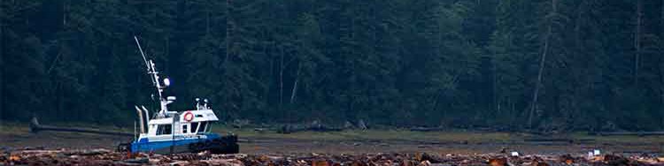
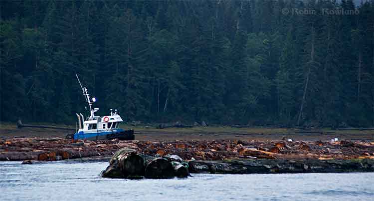
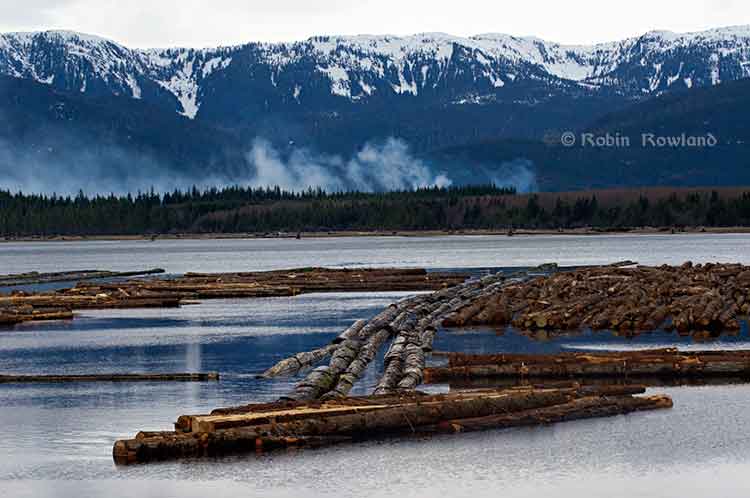
Log booming operations at Clio Bay, August 21, 2013. (Robin Rowland/Northwest Coast Energy News)
Chevron, the company operating the KM LNG project at Bish Cove and the Haisla Nation have proposed that marine clay from the Bish Cove construction site be used to cap more than 10,000 sunken and rotting logs in Clio Bay. Haisla Chief Counsellor Ellis Ross says he hopes that using clay to cover the logs will help remediate the environmentally degrading sections of the Bay. The proposal has brought heated controversy over the plan, both among residents of Kitimat and some members of the Haisla Nation, who say that Clio Bay is full of life and that the capping will cause irreparable damage.
An investigation by Northwest Coast Energy News shows that capping thousands of sunken logs is a lot more complicated and possibly costly than anyone has considered. It is also clear that many of the comments both supporting and opposing the Clio Bay project are based on guesses rather than the extensive scientific literature available on the subject.
Northwest Coast Energy News findings include:
In 1997, the Department of Fisheries and Oceans surveyed sunken log sites in Douglas Channel. The results, published in 2000, identified 52 sites just on Douglas Channel and the Gardner Canal that had various levels of enviromental degradation due to sunken logs. Clio Bay was not the list. The DFO scientists recomended followup studies that never happened.
Scientific studies show that degradation from sunken logs can vary greatly, even within one body of water, due to depth, currents, number of logs, and other factors. So one part of a bay can be vibrant and another part environmentally degraded due to low levels of dissolved oxygen and decaying organic material.
If KM LNG wasn’t paying for the remediation of Clio Bay, it could be very expensive. Capping sunken logs at a cove near Ketchikan, Alaska, that is the same size and shape as Clio Bay cost the US and Alaska governments and the companies involved $2,563,506 in 2000 US dollars. The total cost of the cleanup of the site which was also contaminated with pulp mill effluent was $3,964,000. The estimated cost of capping the logs in the Alaska project was $110 per cubic yard.
The Alaska project shows that a remediation project means while most of the logs in a bay or cove can be capped, in some parts of a water body, depending on currents, contamination and planned future use, the logs have to be removed and the area dredged.
Agencies such as the State of Alaska, the US Environmental Protection Agency and the US Army Corps of Engineers all recommend using “clean sand” for capping operations. Although “clay balls” have been used for capping in some cases, the US officials contacted say they had no record of large amounts of marine clay ever being used for capping. They also noted that every log capping project they were aware of happened in sites that had other forms of contamination such as pulp mill effluent.
Chevron only recently retained the environmental consulting firm Stantec to study Clio Bay. The Department of Fisheries and Oceans has told District of Kitimat Council it recently completed mapping of the seafloor at Clio Bay. The Alaska project was preceded by five years of monitoring and studies before capping and cleanup began.
A letter from Fisheries and Oceans to the District of Kitimat says that Clio Bay has been mapped and the department is planning to monitor any capping operations. However, it appears from the Department of Fisheries and Oceans website that the department has no current policies on remediation since the Conservative government passed two omnibus which weakened the country’s environmental laws. According to the website, new remediation policies are now being drafted. That means that although DFO will be monitoring the Clio Bay operation, it is uncertain what standards DFO will be using to supervise whatever happens in Clio Bay.
Northwest Coast Energy News is continuing its investigation of the sunken logs problem. Expect more stories in the days to come.
Special report: Clio Bay cleanup: Controversial, complicated and costly
Log booming operations at Clio Bay, August 21, 2013 (Robin Rowland/Northwest Coast Energy News)
Updated October 3, 2013, with DFO statement
One of the major concerns about Clio Bay is the possible lack of oxygen to support sealife. While some people have called Clio Bay “dead,” others have pointed to catches of crab, cod and salmon to dispute that.
The experience at Ward Cove, Alaska, even though it was more polluted than Clio Bay, shows that oxygen levels are highly variable, depending on season, location and depth.
In 1995, the DFO`s Institute of Ocean Siences studied dissolved oxygen levels in Minette Bay, and concluded, according to a report posted on the DFO website, that because Minette Bay was stagnant from May to November” and those conditions existed even before industrial development in the Kitimat Valley:
Examination of all the dissolved oxygen data showed that conditions before or early in the industrial development of the region were not significantly different from those observed in the 1995 to 1996 study. On the basis of these analyses we concluded that log storage and handling activities in the bay do not appear to have exacerbated the naturally occurring low dissolved oxygen conditions.
Ward Cove
The US Enviromental Protection Agency studied disolved oxygen levels at Ward Cove during water quality monitoring from 1998 to 2002. The monitoring found that dissolved oxygen levels of less than 4 milligrams per litre commonly occurred in Ward Cove during the summer and early fall. “During this time, hypoxic conditions (dissolved oxygen less than 2 milliggrams per litre) occurred occasionally at and near the bottom and less frequently in midwater areas. Hypoxia can be dangerous to both fish and bottom dwelling species.”
The EPA study showed that water circulation is restricted within Ward cove. A counter-clockwise circulation brings ocean water from Tongass Narrow into the cove along the south shore. That water usually exits after 15 days.
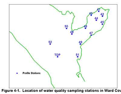
The EPA studied dissolved oxygen in Ward Cove from November 1995 to October 2002, using 13 monitoring stations, nine inside the cove and four outside in Tongass Narrows.
Map of water quality sampling stations in Ward Cove, Alaska (EPA)
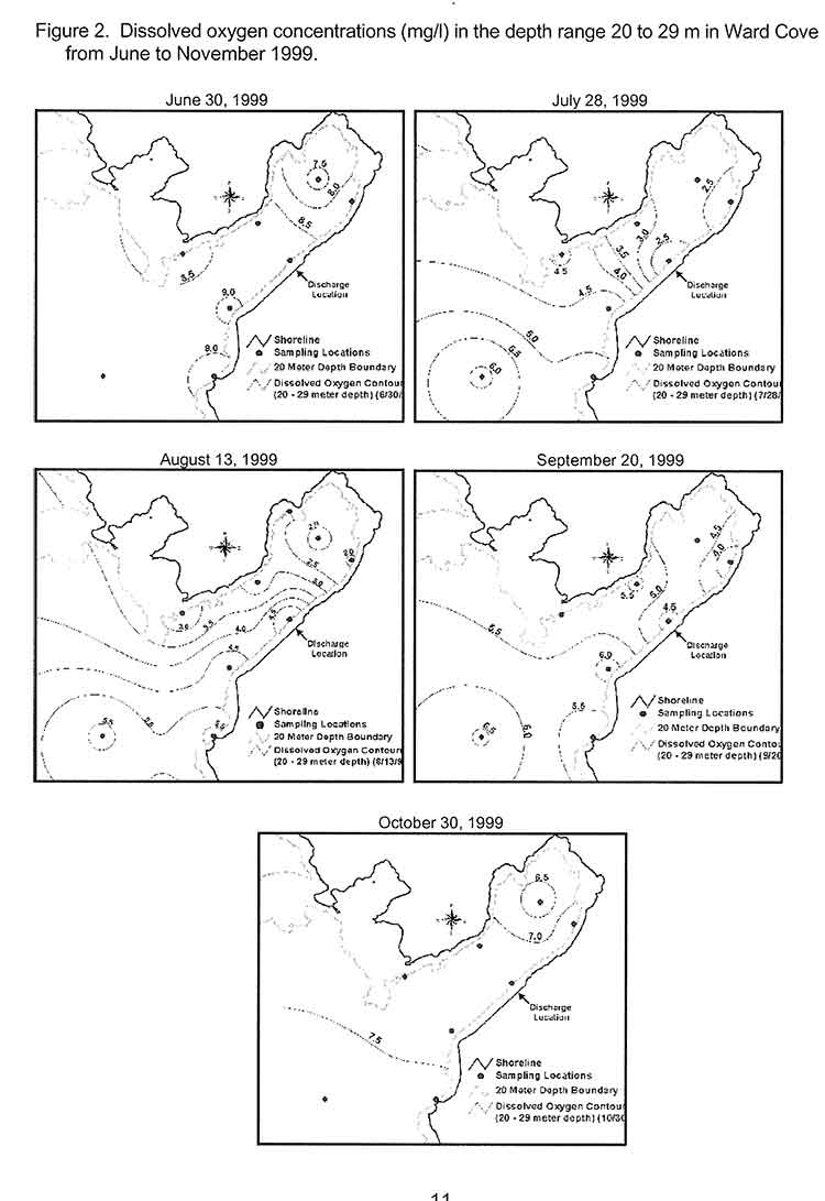
This monitoring found that the water column is strongly stratified during the summer resulting in poor mixing of bottom water. The EPA says during the monitoring period:
dissolved oxygen levels between 2 and 4 mg/1 were commonly observed in Ward Cove. These conditions began at water depths greater than approximately 20 metres in mid to late July and continued until early October, but oxygen levels between 2 and 4 mg/1 may also occur in water as shallow as 15 metres.
The EPA says the normal oxygen level for the surface waters of Ward Cove is approximately 8 mg/1 at 10°C. Under natural conditions and vertical stratification, dissolved oxygen levels in deeper waters can vary considerably and be reduced significantly below 8 mg/1 by respiration and the decay of organic materials, including sunken logs.
Since Clio Bay is deeper than Ward Cove, that means dissolved oxygen levels could be decreased at the greater depths.
Maps showing differing levels of dissolved oxygen during monitoring at Ward Cove. Alaska (EPA)
Salmon
The Ward Cove study also confirmed laboratory studies that showed that salmon can detect and avoid areas of low oxygen. Coho, pink, sockeye, chum, steelhead, Dolly Varden and Cutthroat trout are all native to the cove. Introduced Chinook are also found at Wards Cove.
A Ward Cove report says:
Depressed dissolved oxygen conditions are unlikely to significantly affect the growth of juvenile or adult salmonids migrating through or feeding in or near Ward Cove. Some minor indirect effects, however, may occur as a result of hypoxia-induced changes to food chain organisms inhabiting the cove and adjacent waters.
The growth cycles of the adult stage of all seven anadromous salmon and trout species native to Ward Creek should be completed prior to their arrival in the cove from the ocean. Some feeding by adult cutthroat trout and Dolly Varden may occur in or near the cove as they hold in preparation for entering Ward Creek. The growth of subadult chinook salmon, a fish species not native to Ward Creek, is also not likely affected by exposures to these conditions.
Returning adult salmonids may be present in the cove when the lowest dissolved oxygen and highest water temperatures occur in late summer and early fall. Adult salmonids will usually avoid hypoxic conditions, except when staging to enter freshwater during the latter part of their annual spawning migrations. Severe depressed DO levels at this time in combination with low flows and high water temperatures in Ward Creek can result in adult mortality. Fish kills have not been observed recently in the cove, likely because the depressed DO conditions have not extended into a greater portion of the water column in combination with low flows in Ward Creek.
As for other species, the report says reaction varies, with species that are able to swim often leaving areas of depressed oxygen. Previous studies have shown that bottom dwelling species may be able to tolerate low oxygen for a short time and become susceptible if they don’t swim out of the area. Those species who are are not mobile, have weak swimming abilities, or live within the sediment are more likely to be susceptible.
That means that changes in oxygen level could mean that deaths or migration of mobile bottom dwelling species at a location, leaving the impression that species are no longer around, even though the changes may be seasonal. Scientific studies show that low oxygen levels can also make all species in that area vulnerable to disease due to stress. Low oxygen also limits swimming ability and makes a species more prone to predation.
Minette Bay
Log boom at Minette Bay. April 14, 2013. (Robin Rowland/Northwest Coast Energy News)
From August 1995 until October 1996, the Department of Fisheries and Oceans (Institute of Ocean Sciences and the North Coast Division of Habitat Management) with the support local companies studied the water quality in Minette Bay.
A 1961 study of oceanography of the BC fjords and a second study of in 1968 had already reported finding low dissolved oxygen levels in Minette Bay.
As far back as 1975, the report says:
Concerns have been raised that the poor water quality of the bay is exacerbated if not caused directly by the log handling practices there. Other habitat disruptions have been attributed to the industrial activities associated with log handling practices in this bay, e.g. bottom scouring, bark litter, and sinkers.
The DFO report says that the purpose of our study of Minette Bay was to determine if log handling in the bay “significantly contributed to low dissolved oxygen concentrations.”
The study of Minette Bay was similar to the one then starting at Ward Cove, but on a much smaller scale, checking salinity, temperature and levels of dissolved oxygen.
The report says:
The renewal of Minette Bay deep waters occurs annually during the winter and early spring months. Renewal occurs in the form of multiple events, some of which penetrate to the bottom while others only affect the intermediate waters. These events are caused by the outbreaks of the Arctic air mass over the region. The cold air temperatures reduce run-off thereby increasing surface salinity while at the same time the strong outflow winds push the surface layer away from the head of Kitimat Arm and bring denser water closer to the surface. The cold outflow winds also cool and mix the surface waters. In the stagnant period from May to November, dissolved oxygen concentrations in the deep waters decline rapidly to near zero conditions by July and remain low until the late fall.
The 1995 study concluded, based on surveys and reports from the previous 45 years, that measurements of dissolved oxygen in 1951 before the Alcan smelter was built, through measurements in the 1960, were not different from the 1995 measurements in the deep waters.`and concluded “that log handling practices in the bay have not exacerbated the naturally occurring low DO conditions in the bay.”
`
It goes on to say while log storage and handling at Minette Bay had no apparent effect on dissolved oxygen:
other deleterious effects on water quality and habitat are possible. These impacts might include: the disruption of animal and plant ‘life on and in the sediments by the grounding of log booms or scouring of the bottom sediments by the movement of log booms; the alteration of the natural composition of the sediments and the benthic community by the accumulation of bark, whole logs and other wood debris on the sediments underneath the log storage areas and in the log dump zone; anoxia in sediments due to an increased organic load; and toxic concentrations of leachates from the logs and other wood debris.
It called for further studies of Minette Bay such as using an underwater camera, could provide a cost effective way to visually inspect and classify the bottom sediments. Those sediments could then be sampled
based on the preliminary mapping of sediment characteristics, log handling impacts and visual ·surveys. At these locations the benthic community should be sampled for diversity and species composition. This information by itself or in conjunction with historical surveys in the bay and Kitimat Arm may give a sense of the degree of impact that log handling operations are having on the ecology of Minette Bay.
It also called for studies for “two small inlets that have very shallow sills; Foch Lagoon which has a 4 metre deep sill at low water and the other is Kiskosh Inlet which has a 2 metre deep sill.”
It notes
Kiskosh Inlet has a maximum depth of about 53m and is more like Minette Bay than Foch Lagoon which has a much deeper basin (250m). Their very shallow sills suggest that the deep basin waters in these two inlets may be oxygen depleted. A comparison with Minette Bay may be instructive as there are no log storage or handling activities in either of these inlets.
In 1997, DFO created a list of 52 sites on Douglas Channel that were used as active, abandoned or potential log dump sites, as targets for studies. The east and west sides of Minette Bay were two items on the list. Clio Bay, Foch Lagoon and Kiskosh Inlet were not on that list.
Haisla Chief Counsellor Ellis Ross says that if the Clio Bay capping project works, Minette Bay should be next.
Dissolved oxygen standards
The state of Alaska has set standards for dissolved oxygen in marine water with a minimum of six milligrams per litre in the one metre surface layer for coastal water and 5 milligrams per litre in estuaries, “except where natural conditions cause this value to be depressed,” with an additional standard of a minimum of 4 milligrams per litre at any one point in both coastal waters and estuaries.
In a statement to Northwest Coast Energy News, DFO spokesperson Carrie Mishima said, “Site-specific standards for dissolved oxygen levels will be developed for the enhanced site by sampling a control site having similar habitat parameters.”
It appears from documents posted on the DFO website that dissolved oxygen monitoring has been dismissed by DFO as too expensive until the issue became important to fish farming.
A 2005 DFO report on the Bay of Fundy noted
The time has therefore arrived for Canada to proceed seriously and rapidly toward the development and implementation of adequate dissolved oxygen standards and management protocols for the marine coastal zone and aquaculture. Such an effort will enable us to avoid the serious eco-socio-economic consequences associated with poor water quality. From a risk analyses perspective the dissolved oxygen issue might be classified as manageable. Aquaculture takes place in a relatively small proportion of the Canadian coastline and it is only within some of these areas that aquaculture is intense enough to pose potential problems. Hence, the likelihood of a major aquaculture induced depletion of dissolved oxygen is probably low to moderate and the impact of reductions is also probably low to moderate.
Another 2005 DFO report, again on aquaculture, based on meetings in Ottawa noted:
Dissolved oxygen is not yet an easily applied regulatory tool on a specific case-by-case basis, and views were mixed regarding its promise as a candidate for monitoring environmental quality in the coastal zone. However, it is one of the few options available for monitoring over hard bottoms. It is also a useful tool for predicting and assessing far-field effects in environments where oxygen levels may be a concern.
This despite the fact that Alaska and the EPA had been monitoring dissolved oxygen and setting standards for the previous decade.
Canada does not yet have national standards for dissolved oxygen levels in coastal waters. DFO says “site specific” standards will be applied at Clio Bay, but so far there are no details of what those standards will be.
Special report: Clio Bay cleanup: Controversial, complicated and costly
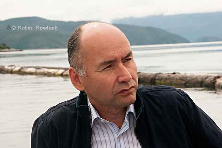
Haisla Nation Chief Counsellor Ellis Ross at Bish Cove, June 19, 2013. (Robin Rowland/Northwest Coast Energy News)
Haisla Chief Counsellor Ellis Ross says that capping the logs at Clio Bay was a Haisla idea, taking advantage of the opportunity to use the marine clay from Bish Cove to bring back the Clio ecosystem.
The Haisla were told by experts who video taped the bottom of Clio Bay that are between 15,000 to 20,000 sunken logs in Clio Bay.
“I know because I’ve spent a lot of time down there plus my dad actually worked for the booming company for years and knew what was going on out there,” Ross said. “There are two extreme areas we’re talking about, if you look at Clio Bay where it’s estimated that there 15,000 to 20,000 logs down there, imagine what Minette Bay looks like? And it’s all iron, it’s steel. It’s not just wood, there are a lot of cables down there.
Cables retrieved from Ward Cove, Alaska, during dredging and capping in 2001. (EPA)
“The Haisla have known about the degradation of our territory for years. The problem we have as Haisla members is to restore the habitiat is that nobody wants to clean up the habitat. This was our idea, after review from technical experts from DFO as well as our own experts. We’re looking for a three way solution, with the company, DFO and the Crown and the Haisla.”
“I’d love to go and catch halibut and cod, like my ancestors used to.”
He said that the Haisla have beem aware of environmental problems from sunken logs for decades and have been asking for cleanup of degraded areas since 2004, not just at Clio Bay, but in the Kildala Arm and at Collins Bay, which were studied by DFO in 1997.
“The logs are down there, they are oxidizing, but no one wants to do anything about it, including the company and including the Crown. We had independent people come in and review it and have them come up with a recommendation. There was a small scale project [involving marine clay] that proved that this could work.
“This system here is killing two birds with one stone, get rid of the clay and try to remediate some of the habitat,” Ross said.
He said that the original estimate of marine clay excavated at Bish Cove was 10,000 cubic metres. That has now risen to about 3.5 million cubic metres because the KM LNG project is digging deeper for the foundation of the LNG terminal. The original plan called for disposing 1.2 million cubic metres at sea and another 1.2 million cubic metres on land.
“The original idea was to dump the clay in the middle of the ocean. In small amounts it could have been mitigated, but in large amounts we said ‘no.’ If we try to dump clay in the middle of the channel, we have no idea where it’s going to end up, what the effect is going to be.” Ross said. “We did the same thing here for the terrestrial side, we said ‘OK that with the rock quarries above Bees Creek,’ use the clay to help remediate that as well, bring it back.”
Asked about Ward Cove in Alaska, where the US Environmental Protection Agency ordered a cleanup, Ross said. “The difference here is that no one is ordering these companies to clean up the sites, they walk away. No one is taking responsiblity, The Haisla are trying to do this within the parameters they’ve given us.So if someone could come in and order these companies and do something, we’ll look for something else to do with the clay. Until that day comes, the Haisla are still stuck with trying to bring back this land by ourselves. If the District of Kitimat wants to pay the bill, great. Let’s see it.
“We need to put pressure on the province or Canada to cleanup these sites. We’ve been trying to do this for the last 30 years. We got nowhere. Before when we talked about getting those logs and cables cleaned up, it fell on deaf ears [at DFO]. They [DFO] had no policy and no authority to hold these companies accountable. So we’re stuck, we’re stuck between a rock and hard place. How do we fix it?”
Ross also noted that Shell’s LNG Canada project also faces remediation problems, “Shell is going to have the same problem, their’s is going to be different, they’re going to have get rid of contamination on the ocean bottom and beneath that it’s basically going to be gravel, it’s not clay, they’re going to have get rid of that product.”
Special report: Clio Bay cleanup: Controversial, complicated and costly
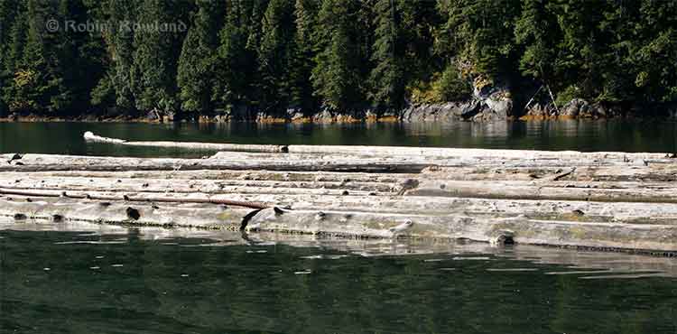
Floating logs at Clio Bay, September 14, 2013. (Robin Rowland/Northwest Coast Energy News)
The forest industry has been operating on the Pacific coast from Oregon to Alaska for more than a century. Over that time, it is likely that millions of logs from booms and other operations have sunk to the bottom of bays, cove, estuaries and inlets along the coast.
During that century, scientists in both Canada and the United States have been studying the effects of the those sunken logs on the sea bottom. It is only in recent years that the cumulative effect of all those logs has become an environmental concern.
As well as logs on the sea bottom, ranging, depending on location, from a couple of hundred to the tens of thousands of logs, there are wood chips, wood fibre and discarded log parts and bark. Often metal cables, bolts, ropes, and other manufactured material either dropped accidentally or deliberately discarded are also found among the old logs, further contaminating the seabed. Compounding the problem of the sea bottom is organic material that would occur naturally on the seabed, including tree trunks, roots, branches, conifer needles, deciduous leaves and other material from terrestrial plants.
Anyone who sails Douglas Channel after a storm can see with all the floating tree trunks in the Channe. That means that storms and spring run off ads debris to the natural pile up of old logs and debris. At logging sites, this natural material, brought in by creeks and rivers, piles up on the already sunken logs.
Over the years, depending on the salinity, teredos, more popularly known as ship worms eat the wood, often leaving a tube of bark that eventually collapses. The rotting wood, bark and other material is often, depending on conditions, pounded into fragments by the action of waves, currents and outflow from rivers. Some species of teredo can live in brackish water, but since teredos are not a fresh water species, that means that logs in fresh or mostly fresh water last longer.
A DFO report on sunken log sites on Douglas Channel, published in 2000, noted:
very few comprehensive, quantitative field studies describing the effects of wood and bark have been published and those that did focused on log handling and storage sites which handled high volumes of more than one million cubic metres.
The DFO report said that thick bark and wood debris deposits resulting from log handling can cause substantial, long-term negative impacts to benthic (sea bottom) ecosystems. Under the worst conditions, the cumulative debris can deprive an area of oxygen and, according to DFO, “virtually eliminate aerobic” sea bottom animal life.
The report noted that studies had shown that “negative biological impacts were localized,” but added that “the cumulative effect of several hundred sites located on the B.C. coast is currently unknown.”
Studying the problem has been a low priority for DFO and other agencies and that meant a limited budget and few studies. Other problems is that, according to the DFO, parts of BC fjords are steep and “much of the likely impacted habitat is beyond diver range.” There is also pressure to study the effect on “economically or socially important species.” Although the use of remotely operated vehicles has increased since the 2000 report, using an ROV can also be a budget buster for a low priority project.
As the ready timber supply in British Columbia particularly old growth forest declined in the last part of the twentieth century, the DFO report says “forest companies have harvested areas where access is more difficult and cut-blocks are smaller.” That meant many smaller dump sites were developed that were used for only one to five years. Plans for log handling at the time, DFO said, were evolving to ensure ensure that fisheries resources and overall fish production capability were not adversely affected by development of log handling facilities and planning was focused on ensuring that sites for log handling facilities did “not have sensitive fish habitats or fisheries resources (such as eel grass beds or shellfish resources) which may be affected by the log handling,”
One of the reasons for the disagreements over Clio Bay is that while some people call it “dead” saying there are no halibut and fewer cod, others say that Clio Bay is very much alive, pointing out that it is easy to catch crab and rock cod.
The studies that have looked at life on the bottom of log dumps sites have shown that it can be highly variable even within one bay or cove, with many factors creating small local ecosystems, including depth, nature of the sea bottom, for example sand, mud, clay or a mixture, whether or not the sea bottom sediment is “enriched,” the flow of currents, fresh water flow into the site, the percentage of wood on the bottom, the percentage of bark on the bottom, whether the wood and/or bark debris is “continuous’ or “discontinuous,” whether or not the seabed is contaminated as was the case with the cleanup of pulp mill sites at Ward Cove and Sitka, Alaska.
Ward Cove had been so polluted for decades by pulp mill effluent that it was eligible for US Superfund clean up funding and was estimated to hold 16,000 sunken logs. At the same time, an EPA report on Ward Cove noted that at the point Ward Creek emptied into Ward Cove was “a popular sport fishing location during salmon season, including commercially guided fishing. Some sport fishing and personal-use crab pot fishing has taken place in the past and may continue in the waters of the cove.” At the same time of the cleanup, the EPA identified that the degradation of Ward Cove put at risk eight species of salmon, 75 “non-salmonid esturine and marine fish species and benthic invertebrate fauna.” (The EPA says Ward Cove is recovering after the reclamation and fishing is continuing)
In other words, those say Clio Bay is in danger and those who say Clio Bay is a rich source of life are likely both right.
For example, while Chris Picard’s (then with the University of Victoria, now with the Gitga’at First Nation) study of Clio Bay said: “Dungeness crabs were observed five times more often in the unimpacted Eagle Bay than in Clio Bay,” and tied that to log dumping and low oxygen.
Picard’s study noted that both Dungeness crabs and sunflower seastars, while more abundant in Eagle Bay, in Clio Bay “both species were several-fold less abundant in wood-dominated habitats in Clio Bay than in non-wood habitats in that bay.”
Several people have pointed out that since Clio Bay is one of the closest crabbing spots to both Kitimat and Kitamaat Village, while Eagle Bay is further down Douglas Channel, overfishing at Clio may be a factor in the reported species decline.
The DFO study noted
The dumping of logs into water down skids can result in the generation of a considerable amount of bark and wood debris. The abrasive action of boom boats and waves during the sorting and storage of bundles can also generate quantities of wood debris. Bark and wood lost during dumping often forms thick, continuous, anoxic fibre mats extended from the base of the dump skids. The debris mat tends to dissipate with distance from the entry point; however, wood debris can often be observed substantial.” distances from the dump skids as seen at all four of the sites sampled. Debris deposits can also be generated as logs resting on the sea floor decay. Wood boring organisms (e.g., Toredo) quickly reduce the wood fibre content of logs, but the bark of some species (e.g., western red cedar (Thuja plicata) which has a high lignin content) is left relatively untouched. The amount of wood debris generated during handling and storage can be different depending on tree species, tidal levels, and dumping methods. Debris accumulation, distribution, and the resulting biological impacts are affected by physical factors including depth, sea floor slope, dump site aspect, water currents, and wind or wave exposure.
One of the main problems with log dumping is that it has the potential to deplete vital oxygen, especially at deeper levels. Seasonal variations can mean that, even if there are thousands of logs at the bottom, the levels of dissolved oxygen can vary. Years of studies at the cleanup site at Ward Cove, Alaska showed how the oxygen levels can vary by season. In Minette Bay, near Kitimat, a DFO study showed that the Minette is somewhat stagnant and therefore has naturally occurring low oxygen levels, but also that the low levels usually last from May to November and are worst in July.
The DFO study went on to say that oxygen poor thick anoxic bark or wood fibre deposits are likely to cause damage to bottom dwelling species, although in the short term, logs may not cause any impacts. It says that some studies have indicated that large pieces of wood debris can, for a time, increase diversity by providing suitable base for some filter feeders as well as food and cover for epifauna and wood boring organisms. Several species not normally found in sand-bed have occasionally been found in log and rock debris.
(Studies have shown that salmon the ability to detect low oxygen areas and avoid them and some active invertebrate species can migrate away from a low oxygen area.)
In the long term, logs do decay and the wood and bark left behind can contribute to the wood debris accumulation. One study cited by the DFO survey of Douglas Channel found found that crabs avoided bark deposits when given a choice but when they were forced to live among bark deposits, they were had fewer offspring, had lower feeding rates, and had a decreased survivorship.
One theory is that the decaying organic material produces hydrogen sulphide in combination with ammonia and other unmeasured toxicants. One study of Dungeness crabs, living at a log dump in southeast Alaska with elevated hydrogen sulphide and ammonia concentrations in the bark debris, shows the colony had less than half as many reproducing females as a control population.
The EPA and Alaska reports from Ward Cove show that sand capping does help restore the seabed environment.
[rps-include post=5057]