Both the RCMP and Kitimat Fire and Rescue are warning residents to stay away from the Kitimat River until the high water recedes. As well there are likely new hazards from a possible change in the river’s path due to the high water and as well as from debris in Douglas Channel.
Both detachment commander Staff Sergeant James McLaren and Fire Chief Trent Bossance made a special presentation to District of Kitimat Council Monday night to bring council up to date on the events that began early Monday morning.
The riverbanks are still hazardous, McLaren told Council and he urged that everyone stay away for at least the next two days. Anyone going out to fish in the Kitimat Arm of Douglas Channel, may also face hazards from snags, logs and debris such as floating propane cans. Bossance told Council in reply to a question from Councillor Larry Walker.
As well, Bossance told Council that the sudden deluge that began on Sunday afternoon is “not typical at all like the regular October flooding” that may be seen on the river.
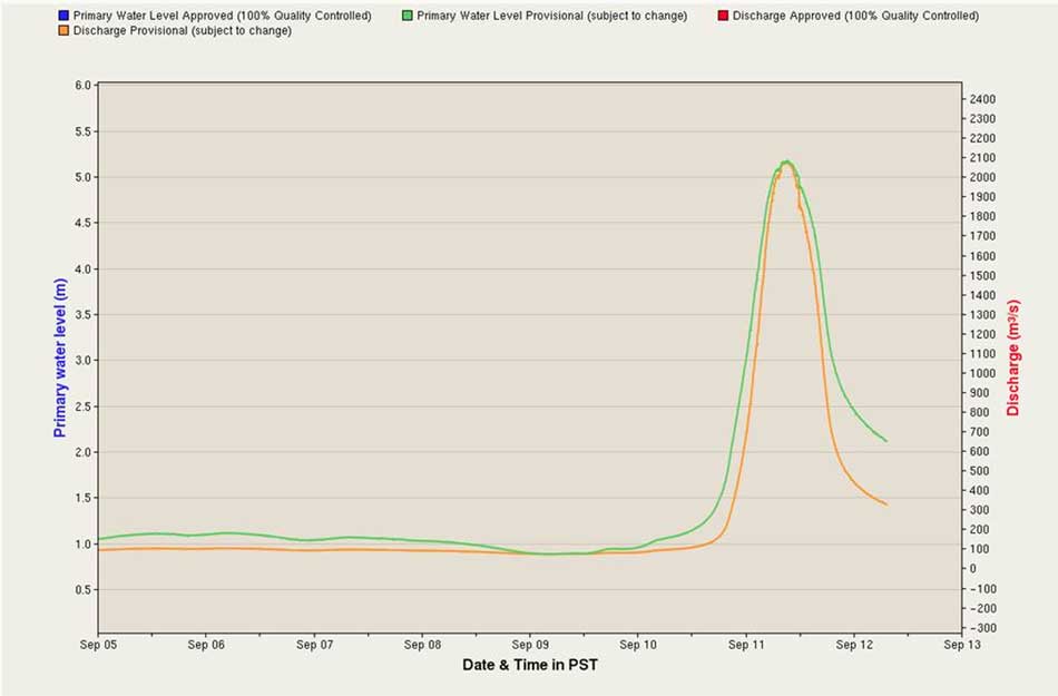
Environment Canada chart of the spike in the Kitimat River levels, as presented to District Council. (Environment Canada)
Bossance warned that due to the volume and speed of the water it is likely that some parts of the river bed and river course have changed, and that the sandbars and snag areas that people may be familiar with may have shifted.
The effects of the flood are being monitored by RCMP, Fire and Rescue, Conservation officers, Fisheries and Oceans and provincial environmental officials.
Bossance said that the consensus of those officials is that the flood situation is unique in the history of Kitimat. Environment Canada issued a severe rainfall warning at noon on Sunday.
Bossance told Council that people who were able to leave the riverbank said that they were able to walk out at about one a.m. By 2:30 am, the river had risen so rapidly—about four metres—that by then people were trapped and calling 911 for help. McLaren said the RCMP immediately asked for the assistance of Kitimat Search and Rescue, who then requested assistance from Terrace Swift Water Rescue. Those units rescued twelve people from the riverbank.
A helicopter was called in and rescued two people. The helicopter then made a sweep of the river bank but found no one else in danger.
McLaren told Council that as of 7 pm Monday no one had been reported missing or overdue.
The number of flooded vehicles or vehicles swept into the river is not certain, McLaren said, but the number is estimated between twelve and fourteen ranging from large recreational vehicles to cars. A preliminary assessment by ICBC indicates that the damage or loss of vehicles will be covered but that will have to be confirmed by the vehicle owners.
Bossance said that high tide was not that much of a factor since it occurred at 5:30 am. Most of the high water was runoff from the upper Kitimat River.
Of the fourteen people rescued two were Kitimat residents, the rest from out of town. Emergency social services has assisted those needed to find housing.
The RCMP will continue increased patrols in the river area until the danger has passed.
That’s one of the predictions from a new study from the University of British Columbia, looking at the future of the fishery on the coast.
The study concentrates on the First Nations fishery and warns that aboriginal people could face a catastrophic decline in the harvest of traditional species, especially salmon and herring roe on kelp over the next thirty years, a decline that will also have an equally devastating effect on commercial and recreational fishing.
The main cause of the decline is climate change and the warming of the coastal waters. The study projected “modest to severe declines in catch potential” for all current commercial fisheries along the coast.
The study says that for the First Nations the between $28 million to $36 million in revenue they got from fishing between 2001 and 2010 could fall by up to 90 per cent depending on how the climate changes.
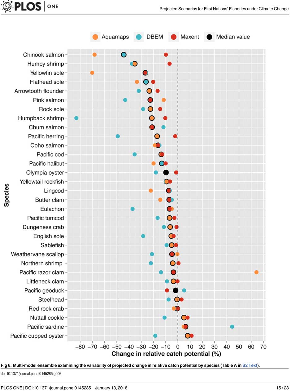
A chart from the UBC study shows possible decline in fish species under different climate scenarios. (PLOS1)
One scenario calls for a decline of up to 40 per cent in chinook and pink salmon.
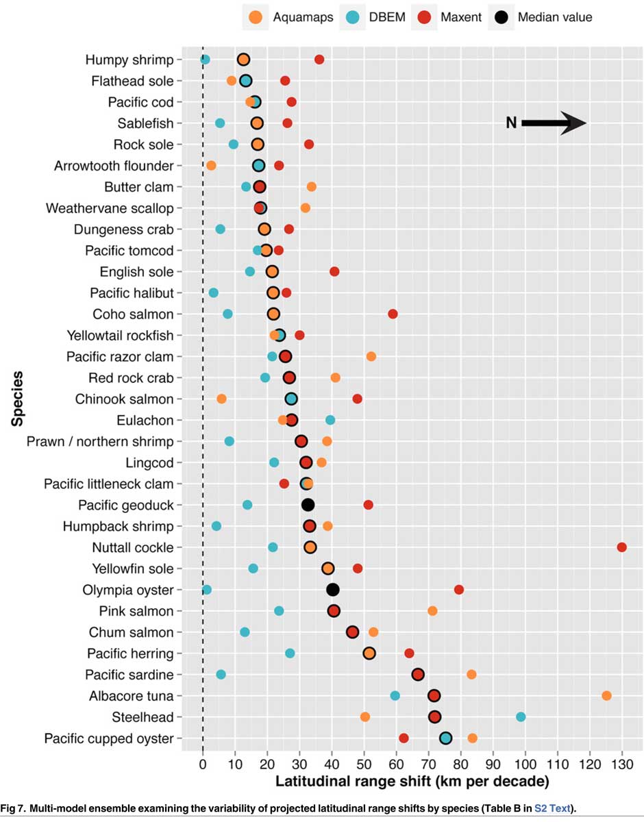
If there is any good news, if you can call it that, the decline will be not as bad in northern coastal waters as it will be the warmer waters near the Lower Mainland and southern Vancouver Island. The range of some species, including salmon, herring, halibut and possibly oolichan will move to farther north along the BC Coast and into Alaskan waters.
That means in time the warming waters will also encourage an increase in other species, including sardines and some clams.
The changing oceans mean that “an increase in the relative abundance of warmer-water species was projected to lead to new or increased opportunities for commercial harvests by 2050.”
The study is urging the First Nations and other stakeholders in the British Columbia fishery to start long term planning immediately to anticipate changes in the coming decades.
The team of scientists led by Lauren Weatherdon, a graduate student at UBC, noted that while previous studies have looked at the impact of climate change on large-scale commercial fisheries, “few efforts have been made to quantitatively project impacts on small-scale subsistence and commercial fisheries that are economically, socially and culturally important to many coastal communities.”
The study was conducted in cooperation with the BC First Nations Fisheries Council and looked its seven coastal administrative regions “forming a sample of groups with diverse marine resources, geographical locations, territorial sizes, and treaty statuses.”
Within those regions 16 First Nations participated in the study, some under their treaty councils, including the Council of the Haida Nation, the Tsimshian Nations Treaty Society (including the Gitga’at at Hartley Bay and the Kitselas and Kitsumkalum near Terrace) and the Maa-nulth First Nations. The Heiltsuk First Nation at Bella Bella participated as an independent group.
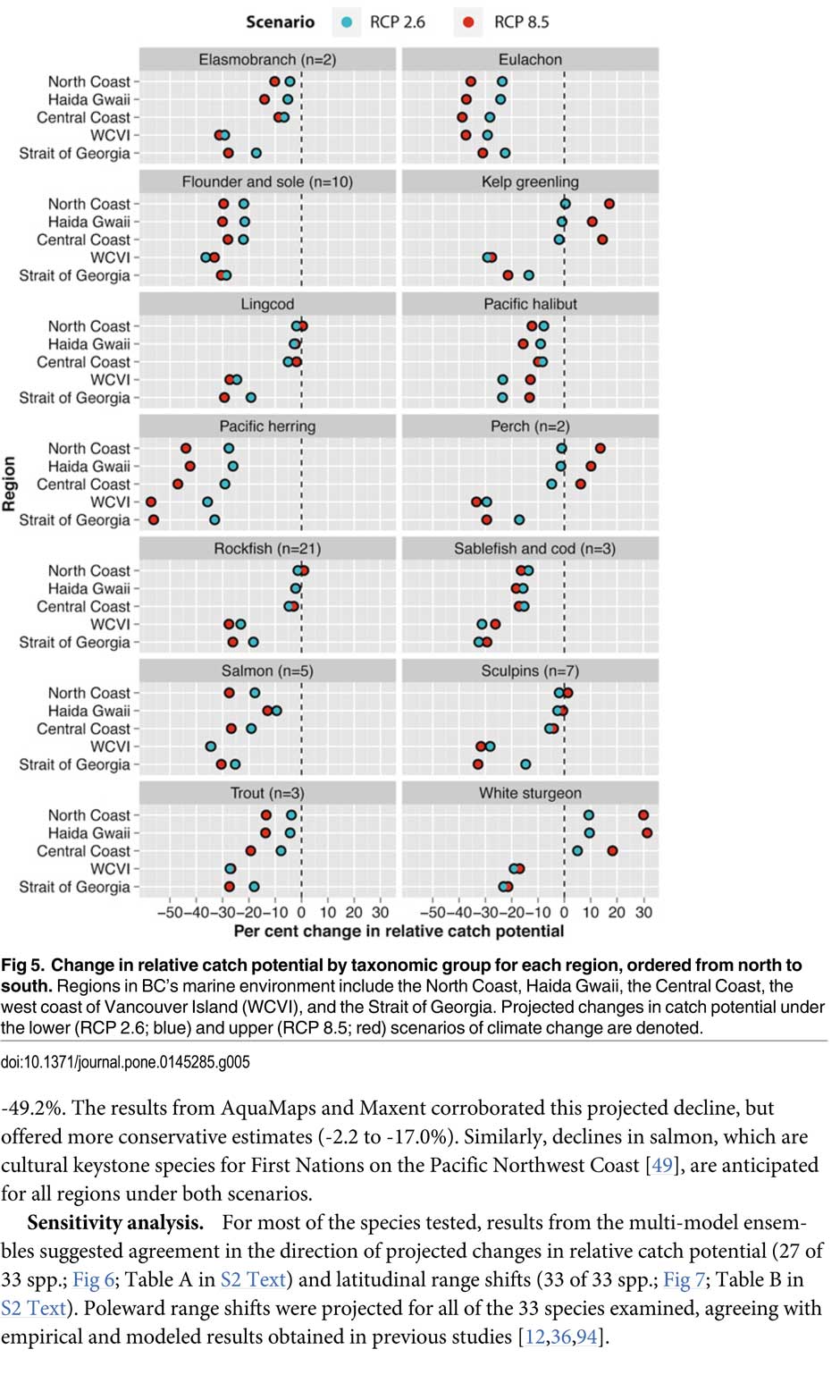
The FNFC’s administrative regions intersect with five distinct ecological regions: the North Coast, comprising the Hecate Strait and Dixon Entrance; Haida Gwaii, which includes the waters surrounding the islands; the Central Coast, including Queen Charlotte Sound, Queen Charlotte Strait, and the southern tip of Hecate Strait; the Strait of Georgia; and the west coast of Vancouver Island (WCVI) .
The study says First Nations are likely to be exposed to different climate-related impacts on fisheries due to the differing ecological and biogeographical characteristics of these regions and to differing traditional and commercial harvests.
The study used a “dynamic bioclimate envelope” computer model to look at the changes to the distribution and relative abundances of the BC coastal species under two climate change scenarios, a high greenhouse gas model where society can’t curb emissions and a low greenhouse gas emission scenarios, depending on how society is able to curb the increase.
The study looked at ocean properties—including sea surface temperature, sea bottom temperature, salinity, oxygen concentration, surface action, and net primary production—using data from the US National Ocean and Atmospheric Administrations’ climate-related earth system model.
Climate change will mean that current species on the BC coast will “shift polewards.”
The study showed that by 2050, there could be declines in 87 of the 98 species in the study.
Greater losses in what the study calls “species richness” is likely to occur towards the southern coast of British Columbia, falling primarily between 48°N and 51°N. But, overall, species richness along coastal BC will continue—only with different species.
Most significantly the study projects a decline in the overall salmon catch from 17.1 per cent to 29.2 per cent, depending on the region and climate.
All aspects of the herring fishery, including roe herring, spawn-on-kelp, and the food and bait fishery could decline between 28.1 per cent and 49.2 per cent depending on the region.
The future of the oolichan is the most uncertain. One of the models studied projected a further 37.1 per cent decline in the oolichan, while other models called for for a decline between 5 per cent and 6.8 per cent. That will depend on how well, the oolichan already threatened in most regions of British Columbia are able to adapt to warmer waters or find a way to move their range northward.
The study says white sturgeon and Pacific sardines were projected to increase in abundance under both climate change scenarios, while manila clams were projected to increase in abundance by 14.5 per cent in one of the models. The eight remaining species showed little change.
The study suggests that the southern territories (Tsawwassen, Tla’amin, and Maa-nulth First Nations) will likely see a reduction in catch potential between -15.2 per cent and -27.8 per cent depending on how the climate changes.
On the north coast. The Haida and Tsimshian First Nations and those situated along the central or north-eastern coasts of Vancouver Island (Heiltsuk and ‘Namgis First Nations) would likely see smaller reductions in relative catch for each territory, with estimates falling between -3.2 per cent and -8.2 per cent.
The study shows that for the First Nations along the North and Central Coasts of British Columbia (Gitga’at and Haida, and Heiltsuk and ‘Namgis) there will be neutral or positive shifts in catch potential for white sturgeon, kelp greenling, and two species of perch under both scenarios.
While varying regionally, both scenarios also suggested either a slight cumulative decline or negligible change in catch potential for clams, rockfish, lingcod, and sculpins across the North and Central Coast.
One potential problem the study suggests is that fishers in southern British Columbia may, in the future, try to move north to follow the harvest, leading to potential conflicts. The cost of travel, may, however, discourage that.
One of the recommendations from the study is that First Nations revive the traditional clam gardens.
Traditional clam beds serve as an ideal example of a method that could be applied to offset climatic impacts through internalized mechanisms, using local cultivation to generate increased productivity by enhancing native habitat rather than redirecting extraction efforts towards other regions or species. Clam gardens constructed in a manner akin to those situated near ancient settlements of the Northern Coast Salish and Laich-kwil-tach First Nations have been found to generate higher clam densities, biomass, and growth rates than non-walled beaches . These benefits were observed for Pacific littleneck clams and butter clams , two clams that are of cultural, economic, and ecological importance to the region Reinstating clam beds in First Nations’ territorial lands has been suggested as a means of simultaneously achieving local conservation and cultural objectives and may thereby provide a politically and ecologically viable option for mitigating climate-related impacts.
The most important recommendation is that the First Nations and other stakeholders start cooperating immediately to offset how the changing climate with affect the fishery:
Management of salmon and herring stocks has been highly contentious due to the myriad of stakeholders who depend upon them, which include First Nations, recreational fisheries, and commercial fisheries….
Aside from fulfilling societal needs, salmon serve as key ecological components of the Pacific Northwest Coast, functioning as the mechanisms by which nutrients are transferred from the ocean to freshwater and terrestrial ecosystems
It says the projections show that a “redistribution of fishing effort” will not “fully offset declines in salmon and herring”
attaining a state of collaboration between First Nations, DFO, and other sectors has the potential to yield beneficial ecological and political results, if implemented correctly. Parallels exist between First Nations’ traditional fisheries management approaches and “modern” approaches (e.g., spatial management, mariculture, selective fishing, fishing closures), with differences arising primarily due to diverging worldviews.
It recommends local application of First Nations’ traditional management strategies to “provide opportunities to collaboratively engage in adaptive ecosystem-based management and to coordinate efforts to attain conservation objectives.”
They give an example of how the Nisga’a Nation have ensured their equal partnership in management by employing traditional fish wheel technology to monitor and assess stocks and by leveraging traditional ecosystem-based management practices that could be applied to plan long-term objectives and management approaches.
It concludes by saying that joint-management will not only work to reduce the impact of climate change but also head off potential conflict.
Through such joint-management regimes, traditional fisheries management strategies could be applied to advance localized research directives and to reduce impacts on stocks under unprecedented environmental change. Moreover, the risk of conflict over declining resources underlines the need to establish common and equitable ground to ensure successful joint management of fisheries, and to leverage collective expertise.
Chart from the study showing which fish species will move north up the coast as the climate changes. (PLOS1)
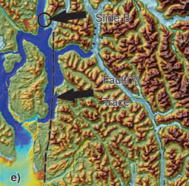
Three studies of the geology of Douglas Channel are near completion and publication, according to Natural Resources Canada. That news comes as studies, released today, warn of a major megathrust earthquake on the fault west of Haida Gwaii.
Northwest Coast Energy News asked the Geological Survey of Canada if there were any recent updates available after the agency said that a survey had located a “possible fault” on Hawkesbury Island during studies for the Enbridge Northern Gateway Joint Review Panel.
Natural Resources Canada responded with a statement: “NRCan continues to conduct research studies in the area, including study of possible faults. Three scientific expeditions have been completed on board Coast Guard research ships. The first two reports are in the final stages of editing, and will be published in the coming months. The third expedition was just completed; therefore the third report will be available later.”
More recently there were slope failures nearer to Kitimat. The first slope failure occurred on October 17, 1974, triggering a 2.4 metre tsunami at low tide. Then on April 27, 1975 there was a second slope failure near low tide on the northeast slope of the Kitimat Arm that generated an 8.2 metre tsunami. The 1975 tsunami destroyed the Northland Navigation dock near Kitimat and damaged the Haisla First Nation docks at Kitamaat Village.
Thomas James, of the Geological Survey told Northwest Coast Energy news about the team’s finding on the Haida Gwaii earthquake: “The studies focused on the Haida Gwaii and Craig earthquakes which happened at the Pacific and North American plate boundary, west of Haida Gwaii, so east of Haida Gwaii there’s no comparable plate boundaries that gives rise of historic sieismisticity.”
As well as the fact that recent studies say the mainland margin coastal zone has had very little historical seismicity, it adds no currently active faults have been identified. A study ten years ago identified some very ancient faults which have not been active since the Eocene, about 33 to 56 million years ago.
GPS studies show that in northwestern British Columbia coastal block is moving northeast at the rate of just 5 millimetres a year.
On Monday, October 20, 2014, the Minister of Fisheries and Oceans, Gail Shea, stood in the House of Commons during Question Period and proved she is not up for the job.
Answering questions from Opposition MPs about the incident of the Russian container ship, Simushir, which drifted dangerously close to the coast of Haida Gwaii, Shea got up and read a prepared script, a script with answers which ignored centuries of the laws and custom of the sea, as well as Canada’s own laws and treaty obligations, answers probably written by what are now known as “the kids in short pants” in the Prime Minister’s Office.
There was a time in this country when some ministers of the Crown took their responsibilities seriously. That idea that has decayed over the years and now has been gutted by the adminstration of Stephen Harper. As Ottawa pundits have noted recently, only a small handful of cabinet ministers in the Harper government have any real responsibility and only those are permitted to answer questions by themselves in the Commons. According to most Ottawa insiders, the less important ministers, like Shea, are basically told what to do by the prime minister’s office.
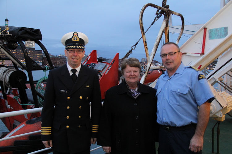
Gail Shea, Minister of Fisheries and Oceans, visited the Canadian Coast Guard Ship Leonard J. Cowley on Friday, December 6, 2013, to examine the fast rescue craft launching mechanism for offshore fishery patrols with Regional Director, Fleet, Stephen Decker and Captain Kerry Evely, Commanding Officer. The Cowley conducts fisheries patrols and monitors fishing activities under Canada’s commitment to the Northwest Atlantic Fisheries Organization. (DFO)
If the House of Commons under Harper could fall any lower, Shea’s attitude (or more likely the PMO’s attitude) on ship and coastal safety takes the Commons and ministerial responsibility to a new low—the bottom of the sea.
Nathan Cullen, NDP MP for Skeena Bulkley Valley, who represents Haida Gwaii first asked. “Mr. Speaker, on Friday, a Russian ship carrying more than 500 million litres of bunker fuel lost all power just off the coast of Haida Gwaii.The Canadian Coast Guard vessel, the Gordon Reid, was hundreds of kilometres away, and it took almost 20 hours for it to reach the drifting ship. Thankfully, favourable winds helped keep the ship from running aground, and a private American tugboat eventually towed it to shore. Is the minister comfortable with a marine safety plan that is based on a U.S. tugboat and blind luck in order to keep B.C.’s coast safe?”
Shea responded.
“Mr. Speaker, luck had nothing to do with the situation. The Russian ship lost power outside Canadian waters in very rough weather. The private sector provides towing service to the marine industry. We are grateful that the Canadian Coast Guard was able to keep the situation under control in very difficult conditions until the tug arrived from Prince Rupert.”
Cullen tried again:
“Mr. Speaker, if the government really wanted to show its gratitude to the Canadian Coast Guard maybe it would not have cut $20 million and 300 personnel from its budget. Even after the Gordon Reid arrived, its tow cable snapped three times. The Russian ship was only about a third as big as the huge supertankers that northern gateway would bring to the very same waters off the west coast. How can Conservatives, especially B.C. Conservatives, back their government’s plan to put hundreds of oil supertankers off the B.C. coast when we do not even have the capacity to protect ourselves right now?”
Shea replied: “Mr. Speaker, this Russian ship lost power outside of Canadian waters. The Canadian Coast Guard responded and kept the situation under control, under very difficult conditions, until the tug arrived from Prince Rupert.
We as a government have committed $6.8 billion through the renewal of the Coast Guard fleet, which demonstrates our support for the safety and security of our marine industries and for our environment.”
Next to try was Liberal MP Lawrence MacAulay from Cardigan.
“Mr. Speaker, the Russian container ship that drifted off the west coast raises serious concerns about the response capability of the Canadian Coast Guard. This serious situation was only under control when a U.S. tugboat arrived.”
Again Shea read her script: “This Russian ship lost power outside Canadian waters. On the west coast, the private sector provides towing services to the marine industry.’
The final attempt by Liberal Joyce Murray, from Vancouver Quadra, also led to a scripted answer. “ this was a private towing vessel that came to tow the vessel that was in trouble.”
Shea’s answers, especially her repeated reference to “territorial waters” set off a series of “What the…?” posts on Twitter from west coast mariners and sailors, wondering if Shea knew anything about maritime law.
The first question one must ask was Shea actually not telling the whole truth to the House of Commons (which is forbidden by House rules) when she said the Simushir was outside Canadian waters? The Haida Nation, in a news release, (pdf) says the Simushir was “drifting about 12 Nautical Miles North West of Gowgaia Bay located off Moresby Island off Haida Gwaii.”
International law defines territorial waters as a belt of coastal waters extending at most 12 nautical miles (22.2 km; 13.8 mi) from the baseline (usually the mean low-water mark) of a coastal state.
As Shea’s own DFO website says Canada has exercised jurisdiction over the territorial sea on its east and west coasts out to 12 nautical miles since 1970, first under the Territorial Sea and Fishing Zones Act and now under the Oceans Act. The baselines for measuring the territorial sea were originally set in 1967. While the exact position can and should be confirmed by the ship’s navigation logs and GPS track, it is clear that the container vessel could have been at one point after it lost power within Canada’s territorial waters.
Even if the Simushir wasn’t exactly within territorial waters, the ship was in what again Shea’s own DFO website calls the “contiguous zone “an area of the sea adjacent to and beyond the territorial sea. Its outer limit measures 24 nautical miles from the normal baseline zone.” In any case, the Simushir was well within what Canada says is its “exclusive economic zone” which extends 200 nautical miles from the coastal baseline.
Law of the Sea
So here is the first question about Shea’s competence.
How could she not know that the Simushir was well within Canadian jurisdiction, as defined by her own department’s website? Even if the minister hadn’t read the departmental website, wasn’t she properly briefed by DFO officials?
The second point, is that whether or not the Simushir was in actually in Canada’s territorial waters is irrelevant. Custom going back centuries, and now the United Nations Convention on the Law of the Sea and even the Canada Shipping Act all require the master of a capable vessel to render assistance once that vessel receives a distress call or sees that another vessel is in distress.
… the master of a ship at sea which is in a position to be able to provide assistance, on receiving a signal from any source that persons are in distress at sea, is bound to proceed with all speed to their assistance, if possible informing them or the search and rescue service that the ship is doing so.
And the Canada Shipping Act requires
Every qualified person who is the master of a vessel in any waters, on receiving a signal from any source that a person, a vessel or an aircraft is in distress, shall proceed with all speed to render assistance and shall, if possible, inform the persons in distress or the sender of the signal.
The master of a vessel in Canadian waters and every qualified person who is the master of avessel in any waters shall render assistance to every person who is found at sea and in danger of being lost.
Note the phrase any waters. Not just in Canadian territorial waters as the Shea, the minister responsible for the ocean seemed to imply in her Commons answers.
That once again calls into question Shea’s fitness to be a minister of the Crown.
If she did not know about the UN conventions on the law of the sea, of which Canada is signatory, or the Canada Shipping Act, she is not up for the job as Minister of Fisheries and Oceans.
If, as the minister responsible for oceans, she knew the law and was told by the PMO to mislead the House of Commons, she is is irresponsible and MPs should ask the Speaker if she actually broke the rules of the House.
Regulation Seven of the Annex on Search and Rescue Services states
Each Contracting Government undertakes to ensure that necessary arrangements are made for distress communication and co-ordination in their area of responsibility and for the rescue of persons in distress at sea around its coasts. These arrangements shall include the establishment, operation and maintenance of such search and rescue facilities as are deemed practicable and necessary, having regard to the density of the seagoing traffic and the navigational dangers, and shall, so far as possible, provide adequate means of locating and rescuing such persons.
Note that the regulation does not say within territorial waters, but “around its coasts.”
Rendering assistance
Canada has always rendered assistance to distressed vessels not just up and down the coast but around the world. Take the case of HMCS Chartlottetown. On February 3, 2008, HMCS Chartlottetown on anti-piracy and anti-terrorist patrol in the North Arabian Sea, spotted a rusty barge with some men stranded on the deck. It turned out the men were from Pakistan and that the vessel towing the barge had sunk with all hands, leaving only the men on the barge alive. The North Arabian Sea is far out side Canadian territorial waters.
In February, 2008. the crew of HMCS Charlottetown rescued the crew of a Pakistani barge that was drifting in the North Arabian sea after the tug that was hauling the barge sank. (Cpl Robert LeBlanc,/Canadian Forces Combat Camera)
On must wonder then if the Harper Government, or at least Minister Shea is suggesting that this country ignore centuries of maritime law and custom and, in the future, pass that barge by because it was not in Canadian waters?
Perhaps buried in the next omnibus bill we will see the Harper Government restrict rescue at sea to Canadian territorial waters. Farfetched? Well that is what Minister Shea’s answer in the Commons seems to suggest.
Given the cutbacks to the Coast Guard services over the past few years, and if there are going to be large tankers, whether LNG or bitumen, on the west coast, it is an open question whether or not the Harper government has actually made those “arrangements shall include the establishment, operation and maintenance of such search and rescue facilities as are deemed practicable and necessary, having regard to the density of the seagoing traffic and the navigational dangers, and shall, so far as possible, provide adequate means of locating and rescuing such persons.”
Now comes the question of the use of the tug Barbara Foss and the two Smit tugs that later joined to tow the Simushir into Prince Rupert harbour.
It is the responibility of the owner or manager of a disabled vessel, large or small, to contract with a tug or towing service to safely take it back to port. But, and it’s a big but, the tow begins only when it is safe to do so, if there is a danger of the ship foundering, sinking or running aground, it is the obligation of all the responding vessels to render assistance, not just the tug contracted to do the job.
(There are reports that the Simushir owners chose to hire the Barbara Foss rather than the heavy duty Smit tugs available at Prince Rupert. Jonathan Whitworth, CEO of Seaspan told Gary Mason of The Globe and Mail that there are about 80 boats on the west coast, capable of heavy-duty towing, but noted that as in the case of the Simushir, those vessels may not be available when needed)
While around the Lower Mainland of BC, even a small boat that has run out of gas or has engine trouble can get commercial assistance from many service providers, the same is not true of the north coast, or at Haida Gwaii, where are no such regular services. Seapan’s Whitworth told The Globe and Mail there is often a 6,000 horsepower log hauling tug that works off Haida Gwaii. but he also noted that it would be too expensive to have a tug permanently moored on the archipelago.
That means mariners who run out of gas or have engine trouble, say on Douglas Channel, have to call Prince Rupert Coast Guard radio and request assistance either from nearby vessels or from the volunteer Royal Canadian Marine Search and Rescue service. RCMSAR policy says that a the rescue boat will not tow a vessel if “commercial assistance is reguarly available.” If commercial assistance is not available RCMSAR is only obligated to tow the boat as far as a “safe haven,” where the boat can tie up safely or contract for that “commercial assistance.”
Here on Douglas Channel the safe haven is usually Kitimat harbour and thus during the summer frequently either a good Samaritan vessel or RCMSAR take the disabled vessel all the way to MK Bay.
Shea’s pat answer to the Opposition questions only betrayed the fact that the east coast minister is woefully ignorant of conditions on the northern coast of British Columbia.
In the old days, a minister who screwed up so badly would be asked to resign. That never happens any more. Ministerial responsibility has sunk to the bottom of the sea.
The bigger picture question seems to be. Why, if the Harper government is so anxious to get hydrocarbons, whether bitumen or natural gas to “tide water” does it keep going out of its way to show its contempt for the people who live on Canada’s west coast?
A note for the voters of Prince Edward Island, where Shea is the member for Egmont. Consider this, if a ship gets into trouble outside the 12 mile limit, trouble that could threaten your beautiful red sandy beaches, you’re likely on your own.
The United States says acidification of the oceans means there is an already growing risk to the northwest coast fishery, including crab and salmon, according to studies released by the National Oceanic and Atmospheric Administration.
As more carbon dioxide is released into the atmosphere and absorbed by the oceans, the water is becoming more acidic and that affects many species, especially shellfish, dissolving the shells.
A NOAA study released today of environmental and economic risks to the Alaska fishery says:
Many of Alaska’s nutritionally and economically valuable marine fisheries are located in waters that are already experiencing ocean acidification, and will see more in the near future…. Communities in southeast and southwest Alaska face the highest risk from ocean acidification because they rely heavily on fisheries that are expected to be most affected by ocean acidification…
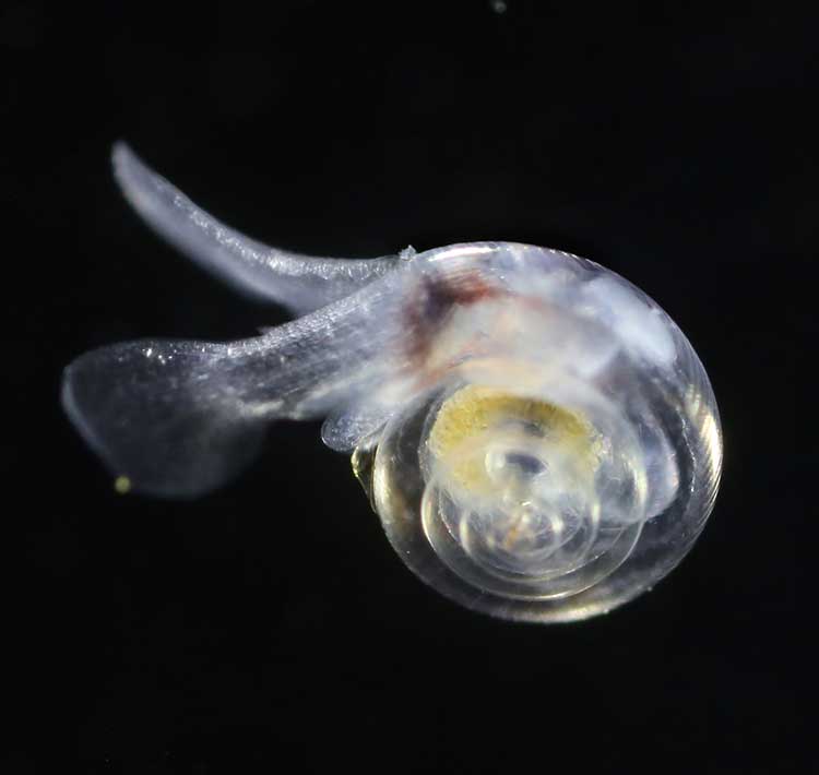
An earlier NOAA study, released in April, identified a long term threat to the salmon fishery as small ocean snails called pteropods which are a prime food source for pink salmon are already being affected by the acidification of the ocean.
This photograph from NOAA of a pteropod, important in the ocean diet of pink salmon, shows the first evidence of marine snails from the natural environment along the U.S. West Coast with signs that shells are dissolving. (NOAA)
NOAA says:
The term “ocean acidification” describes the process of ocean water becoming more acidic as a result of absorbing nearly a third of the carbon dioxide released into the atmosphere from human sources. This change in ocean chemistry is affecting marine life, particularly the ability of shellfish, corals and small creatures in the early stages of the food chain to build skeletons or shells.
Today’s NOAA study is the first published research by the Synthesis of Arctic Research (SOAR) program, which is supported by an US inter-agency agreement between NOAA’s Office of Oceanic and Atmospheric Research and the Bureau of Ocean Energy Management (BOEM) Alaska Region.
Des Nobles, President of Local #37 Fish [UFAWU-UNIFOR] told Northwest Coast Energy News that the fisheries union and other fisheries groups in Prince Rupert have asked both the Canadian federal and the BC provincial governments for action on ocean acidification. Nobles says so far those requests have been ignored,
Threat to crabs
The studies show that red king crab and tanner crab grow more slowly and don’t survive as well in more acidic waters. Alaska’s coastal waters are particularly vulnerable to ocean acidification because of cold water that can absorb more carbon dioxide and unique ocean circulation patterns which bring naturally acidic deep ocean waters to the surface.
“We went beyond the traditional approach of looking at dollars lost or species impacted; we know these fisheries are lifelines for native communities and what we’ve learned will help them adapt to a changing ocean environment,” said Jeremy Mathis, Ph.D., co-lead author of the study, an oceanographer at NOAA’s Pacific Marine Environmental Laboratory in Seattle, and the director of the University of Alaska Fairbanks School of Fisheries and Ocean Sciences Ocean Acidification Research Center.
As for Dungeness crab, Sarah Cooley, a co-author of the Alaska study, who was with the Woods Hole Oceanographic Institution at the time, told Northwest Coast Energy News, “The studies have not been done for Dungeness crab that have been done for king and tanner crab, that’s something we’re keenly aware of. There’s a big knowledge gap at this point.” She says NOAA may soon be looking at pilot study on Dungeness crab.
A healthy pteropod collected during the U.S. West Coast survey cruise. (NOAA)
Risk to Salmon, Mackerel and Herring
In a 2011-2013 survey, a NOAA-led research team found the first evidence: “that acidity of continental shelf waters off the West Coast is dissolving the shells of tiny free-swimming marine snails, called pteropods, which provide food for pink salmon, mackerel and herring.”
The survey estimated that the percentage of pteropods along the west coast with dissolving shells due to ocean acidification had “doubled in the near shore habitat since the pre-industrial era and is on track to triple by 2050 when coastal waters become 70 percent more corrosive than in the pre-industrial era due to human-caused ocean acidification.”
That study documented the movement of corrosive waters onto the continental shelf from April to September during the upwelling season, when winds bring water rich in carbon dioxide up from depths of about 120 to 180 metres to the surface and onto the continental shelf.
“We haven’t done the extensive amount of studies yet on the young salmon fry,” Cooley said. “I would love to see those studies done. I think there is a real need for that information. Salmon are just so so important for the entire Pacific Northwest and up to Alaska.”
In Prince Rupert, Barb Faggetter, an independent oceanographer whose company Ocean Ecology has consulted for the fisherman’s union and NGOs, who was not part of the study, spoke generally about the threat of acidification to the region.
She is currently studying the impact of the proposed Liquified Natural Gas terminals that could be built at Prince Rupert near the Skeena River estuary. Faggetter said that acidification could affect the species eaten by juvenile salmon. “As young juveniles they eat a lot of zooplankton including crustaceans and shell fish larvae.”
She added, “Any of the shell fish in the fishery, including probably things like sea urchins are all organisms that are susceptible to ocean acidification because of the loss of their capacity to actually incorporate calcium carbonate into their shells.”
Faggetter said her studies have concentrated on potential habitat loss near Prince Rupert as a result of dredging and other activities for liquified natural gas development, She adds that ocean acidification “has been a consideration that climate change will further worsen any potential damage that we’re currently looking at.”
Her studies of the Skeena estuary are concentrating on “rating” areas based on the food supply available to juvenile salmon, as well as predation and what habitat is available and the quality of that habitat to identify areas that “are most important for the juvenile salmon coming out of the Skeena River estuary and which are less important.”
She said that climate change and ocean acidification could impact the Skeena estuary and “probably reduce some of the environments that are currently good because they have a good food supply. If ocean acidification reduces that food supply that will no longer be good habitat for them” [juvenile salmon].
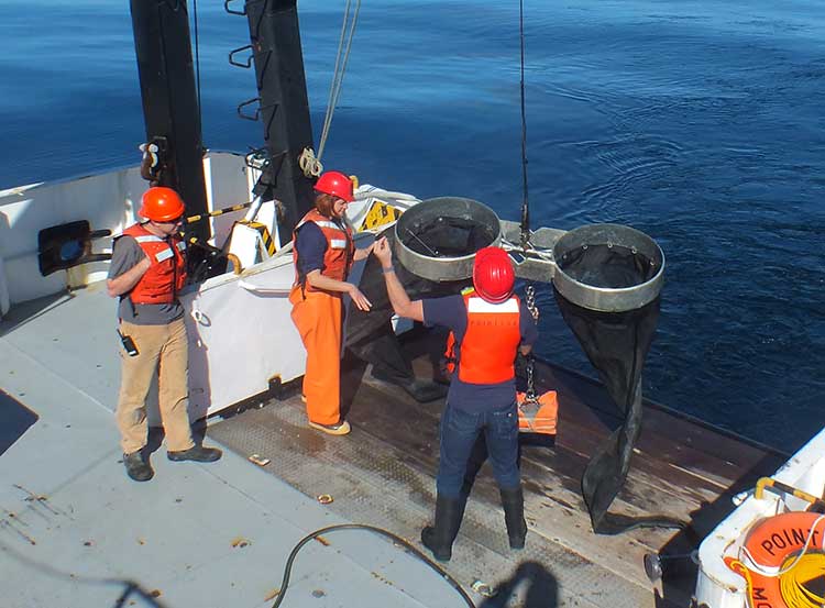
Bongo nets are deployed up to 200 meters deep to catch marine snails (pteropods), which are indicators of the progress of ocean acidification. The pteropod samples were collected during the U.S. West Coast survey cruises in 2011 and 2013. Unlike the US, Canada’s DFO is using models to track what’s happening to pteropods. (NOAA)
The August 2011 NOAA survey of the pteropods was done at sea using “bongo nets” to retrieve the small snails at depths up to 200 metres. The research drew upon a West Coast survey by the NOAA Ocean Acidification Program in that was conducted on board the R/V Wecoma, owned by the National Science Foundation and operated by Oregon State University.
Nina Bednarsek, Ph.D., of NOAA’s Pacific Marine Environmental Laboratory in Seattle, the lead author of the April pteropod paper said, “Our findings are the first evidence that a large fraction of the West Coast pteropod population is being affected by ocean acidification.
“Dissolving coastal pteropod shells point to the need to study how acidification may be affecting the larger marine ecosystem. These near shore waters provide essential habitat to a great diversity of marine species, including many economically important fish that support coastal economies and provide us with food.”
Ecology and economy
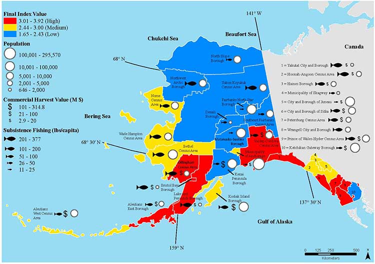
Today’s study on the effects of acidification on the Alaska fishery study examined the potential effects on a state where the fishing industry supports over 100,000 jobs and generates more than $5 billion in annual revenue. Fishery-related tourism also brings in $300 million annually to the state.
A map of Alaska shows the economic and ecological risks to parts of the state from ocean acidification. (NOAA)
The study also shows that approximately 120,000 people or roughly 17 percent of Alaskans rely on subsistence fisheries for most, if not all of their dietary protein. The Alaska subsistence fishery is open to all residents of the state who need it, although a majority of those who participate in the subsistence fishery are Alaska’s First Nations. In that way it is somewhat parallel to Canada’s Food, Ceremonial and Social program for First Nations.
“Ocean acidification is not just an ecological problem—it’s an economic problem,” said Steve Colt, Ph.D., co-author of the study and an economist at the University of Alaska Anchorage. “The people of coastal Alaska, who have always looked to the sea for sustenance and prosperity, will be most affected. But all Alaskans need to understand how and where ocean acidification threatens our marine resources so that we can work together to address the challenges and maintain healthy and productive coastal communities.”
The Alaska study recommends that residents and stakeholders in vulnerable regions prepare for environmental challenge and develop response strategies that incorporate community values and needs.
“This research allows planners to think creatively about ways to help coastal communities withstand environmental change,” said Cooley, who is now science outreach manager at Ocean Conservancy, in Washington, D.C. “Adaptations can be tailored to address specific social and environmental weak points that exist in a community.
“This is really the first time that we’ve been able to go under the hood and really look at the factors that make a particular community in a borough or census are less or more vulnerable from changing conditions resulting from acidification. It gives us a lot of power so that we don’t just look at environmental issues but also look at the social story behind that risk.”
As for the southern part of the Alaska panhandle nearest British Columbia, Cooley said, “What we found is that there is a high relative risk compared to some of the other areas of Alaska and that is because the communities there undertake a lot of subsistence fishing, There tend not be a whole lot of commercial harvests in the fisheries there but they are very very important from a subsistence stand point… And they’re tied to species that we expect to be on the front line of acidification, many of the clam species that are harvested in that area and some of the crab species.”
Long term effects
Libby Jewett, Director of the NOAA Ocean Acidification Program and author of the pteropod study said, “Acidification of our oceans may impact marine ecosystems in a way that threatens the sustainability of the marine resources we depend on.
“Research on the progression and impacts of ocean acidification is vital to understanding the consequences of our burning of fossil fuels.”
“Acidification is happening now,” Cooley said. “We have not yet observed major declines in Alaskan harvested species. In Washington and Oregon they have seen widespread oyster mortality from acidification.
“We don’t have the documentation for what’s happening in Alaska right now but there are a lot of studies staring up right now that will just keep an eye out for that sort of thing, Acidification is going to be continuing progressively over the next decades into the future indefinitely until we really curb carbon dioxide emissions. There’s enough momentum in the system that is going to keep acidification advancing for quite some time.
“What we need to be doing as we cut the carbon dioxide, we need to find ways to strength communities that depend on resources and this study allows us to think differently about that and too really look at how we can strengthen those communities.
Faggetter said. “It’s one more blow to an already complex situation here, My study has been working particularly on eel grass on Flora Bank (pdf) which is a very critical habitat, which is going to be impacted by these potential industrial developments and that impact will affect our juvenile salmon and our salmon fishery very dramatically, that could be further worsened by ocean acidification.”
She said that acidification could also be a long term threat to plans in Prince Rupert to establish a geoduck fishery (pronounced gooey-duck).
The popular large 15 to 20 centimetre clam is harvested in Washington State and southern BC, but so far hasn’t been subject to commercial fishing in the north.
NOAA said today’s study shows that by examining all the factors that contribute to risk, more opportunities can be found to prevent harm to human communities at a local level. Decision-makers can address socioeconomic factors that lower the ability of people and communities to adapt to environmental change, such as low incomes, poor nutrition, lack of educational attainment and lack of diverse employment opportunities.
NOAA’s Ocean Acidification Program and the state of Alaska are also developing tools to help industry adapt to increasing acidity.
The new NOAA study is the first published research by the Synthesis of Arctic Research (SOAR) program. which is supported by an inter-agency agreement between NOAA’s Office of Oceanic and Atmospheric Research and the Bureau of Ocean Energy Management (BOEM) Alaska Region.
It comes down to the idea that Harper will approve Gateway “in the national interest,” count on a vote split between the NDP and Liberals in British Columbia to avoid any consequences to the Conservative majority and then leave it up to Enbridge to actually get the job of building the pipeline and terminal project done.
Mason quotes “ a senior member of Mr. Harper’s government,” and while Mason doesn’t say what part of Canada the source is from, (unlikely in my view the source is from BC) what the member told Mason reveals that the Harper government is still mired in it the Matrix-world that has always governed its policy on Northern Gateway.
The first step, apparently coming in the next few days, is that the Harper government “rigorous” new tanker protocols for traffic along the west coast.
Even if the protocols are new, just who is going to enforce those policies?
Mason says:
Even if Gateway and the Kinder Morgan expansion went ahead, he argued, B.C. would still only see about 60 per cent of the annual oil tanker traffic the neighbouring state of Washington deals with. And yet Washington has an exceptionally clean record when it comes to the safe transport of oil in and out of its harbours – this, he noted, while operating under marine safety regulations that are not as rigorous as the ones Ottawa intends to put in place for the shipment of oil along the West Coast.
There are a lot big problems with that statement.
First, there’s an organization that the Mason’s source may have heard of known as the United States Coast Guard. The United States rigorously enforces its “weak” regulations, while Canada’s Coast Guard is plagued by staff shortages and budget cuts.
Second, the State of Washington also rigorously enforces its environmental regulations, not only on the coast but across the state. I have been told by retired British Columbia forestry and environmental officials (not to mention Fisheries and Oceans) that there are often more state environmental watch dogs in most Washington State counties than in all of northern British Columbia where the Northern Gateway is supposed to be going.
The September 2013, report by the US National Oceanographic and Atmospheric Administration on the export of Canadian bitumen sands through the US shows that the Washington Department of Ecology is working on strengthening regulations for both pipelines and (where it’s in state jurisdiction) tanker traffic. The same report says the state of Alaska Department of Environmental Conservation is updating its plans and possible regulations in anticipation that bitumen filled tanker traffic from Kitimat would come close to the coast en route to Asia.
Third, the coast of northern British Columbia is more rugged and stormy than the waters off Washington.
Who pays?
The one factor that the urban media seems to ignore, is the big question.
Who pays?
Who pays to enforce the 209 conditions that the Joint Review Panel imposed on the Northern Gateway project?
If the Harper government announces new tanker regulations in the coming days, who pays to enforce those regulations?
There were no provisions in the February budget for enforcing the 209 conditions. Rather there were continuing budget cuts to the very departments that the JRP ruled must be involved in the studying, planning, implementation and enforcement of the 209 conditions, Environment Canada, Fisheries and Oceans and Transport Canada.
So while Mason says “The federal government will play its part in meeting the five conditions laid out by the B.C. government for support of the project,” the response must be “Show me the money!”
During the recent plebiscite campaign, Northern Gateway finally revealed its plans for the “super tugs” that will escort tankers along the coast and up Douglas Channel. Owen McHugh, a Northern Gateway emergency manager said, “Adding these four or five tugs to the north coast provides a rescue capability that doesn’t exist in this format. So for any large commercial vessel that is traveling on our coast, this capacity to protect the waters of the north coast.” Those tugs and Northern Gateway’s plans to station teams at small bases along the coast means that the company is, in effect, creating a parallel, private, coast guard on the BC Coast.
What about the Coast Guard itself? The Harper government has been gutting Coast Guard resources along the coast even before it had its majority. It closed and dismantled the Kitsilano Coast Guard station in Vancouver. There is more dependence on the Royal Canadian Marine Search and Rescue volunteers, who have to raise money locally for modern rescue boats which cost up to $750,000. The money that government was “generously” giving to RCMSAR had to be split up to 70 stations in 42 communities along the coast as well as its administrative and training staff.
And speaking of boats, what about Coast Guard vessels on the coast? As the Globe and Mail has reported, the government’s shipbuilding program is already over budget and behind schedule. The aim is Arctic/Offshore Patrol Ships and new destroyers. With the crippling of HMCS Protecteur that has raised the concerns about the already troubled supply ship program.
Does anyone notice what is missing from that list? What’s missing are better Coast Guard vessels just to police all the expected tanker traffic on the west coast (whether LNG or bitumen) and no mention of dedicated spill response vessels, which under the “polluter pay” policy will likely be left to private contractors (and hope that the ships are available at the time of a spill)
How will we know?
Then there is the question of how will people even know if the 209 conditions are being enforced; whether or not the reports demanded by the Joint Review Panel are going be sitting on the National Energy Board server and ignored.
There is every indication, given the government’s obsession with secrecy that until there is a disaster the Canadian public will never know what’s going on. Harper’s muzzling doesn’t just cover government scientists, it covers the lowest level of bureaucrats, as District of Kitimat Council found out when low level DFO bureaucrats refused to appear publicly before council to discuss the risk to the Kitimat River.
So the scenario is, according to Mason’s source
“I think once this decision is made, Enbridge could have shovels in the ground the next day,” the member said. “They are ready to go. This means the First Nations could start realizing profits from this right away, as opposed to the promised profits from LNG, which may never materialize. I think they need to think about that.”
First, as part of the blunders is that the Conservatives have always made is the assumption that eventually the First Nations of British Columbia can be paid off, ignoring the commitment of the First Nations, especially on the coast, to protect the environment that sustained them for thousands of years.
While the LNG market is volatile, the “member” forgets that most of the First Nations of British Columbia have opposed the Northern Gateway since Enbridge first floated the idea in 2001. The current LNG rush didn’t start until after Japan shut down its nuclear power plants after the March 2011 earthquake, The first major anti-Enbridge rally, “The Solidarity Gathering of Nations” was held at Kitamaat Village in May 2010.
Writing off BC
It appears that Conservatives, in their election strategy have already written off Gateway opponents:
Still, there is a raw political calculus that needs to be taken into account. Polls measuring support for the pr.oject in B.C. vary, but generally have shown that anywhere from 55 to 60 per cent of the province opposes Gateway and 40 to 45 per cent support it. Isn’t that enough to scare off a government that needs critical votes in B.C. to win another majority?
“Let’s say 60 per cent are against it,” he said. “And that vote splits between the Liberals and the NDP come the next election. Who are the 40 per cent going to vote for?”
Mason also speculates that Harper will approve Gateway to stick it to Barack Obama and the delays on Keystone XL. As he points out that’s a political, not an economic decision.
There are civil disobedience classes being held across northwestern BC this month. Access to Information requests by the Vancouver Observer revealed increased RCMP surveillance of the anti-Gateway movement. There has always been talk of a “war in the woods” if the pipeline project is forced on an unwilling population.
So it comes down to a question that Mason and the Conservatives are avoiding. Mason’s source says Northern Gateway is crucial to the national interest:
“At the end of the day, you have to do what’s right, not what’s politically expedient,” he said. “You have to ask: What’s in the best interests of all Canadians?”
So given all that will the Harper government leave Enbridge to tough it out on its own?
Highly unlikely.
But will the Harper government, with its bean counting obsession on balancing the budget be willing to pay for all that is needed?
Highly likely.
There’s lots of marine clay along the pipeline route, laid down by ancient oceans. That brings to mind just one word. Quagmire, not just the wet, sticky BC mud but a political quagmire.
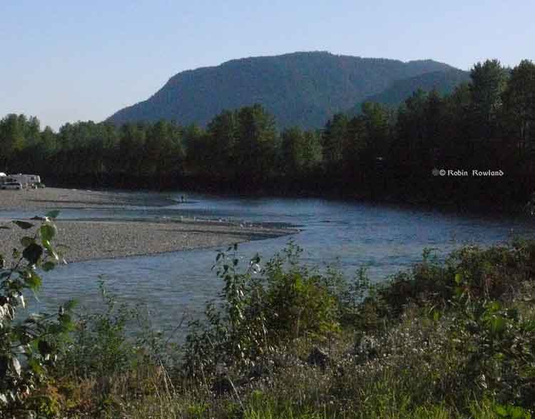
Camping and fishing on the Kitimat River. (Robin Rowland/Northwest Coast Energy News)
Fisheries and Oceans has once again snubbed District of Kitimat Council, by refusing to appear in public before council to answer questions about key issues.
At the Monday, March 10 council meeting, the snub was on the issue of who is responsible for the Kitimat River, facing “increased usage of the riverbank during future construction periods” as well as concerns raised by council earlier over waste left by campers.
In the fall, DFO also refused to appear before council when the department was asked to do so on the issue of Clio Bay remediation.
A report to Council from the District’s Deputy Administrative Officer, Warren Waycheshen, noted that district administration “was recently advised that Fisheries and Oceans are unable to participate in Council meetings, however, they will continue to meet at an operational level to provide information on DFO’s regulatory role.
Waycheshen’s report noted” “District Staff will continue to correspond with Fisheries and Oceans on riverbank camping, and when another operational meeting can be coordinated, Council will be advised of the date and time.”
In other words, DFO officials will continue to meet with district staff and council, in private, but are not accountable to the Kitimat public for their actions, except through what district staff may report to council.
The rest of the report consisted of quotes form the amended Fisheries Act and what appears to be a printout of a DFO Power Point presentation on how it sees its current role.
So now that the federal government appears to have downloaded responsibility to the District, the riverbank ball is now in the hands of Kitimat Council, whether or not the Council actually has jurisdiction.
Councillor Phil Germuth presented a motion asking that District staff prepare a map showing who exactly owns the land along the Kitimat River and what that land is being used for.
In the debate, Councillor Corrine Scott noted, “The first paragraph says Fisheries and Oceans won’t attend a council meeting. Fine, we’ve got that part. But then that’s it. Everything else is about the fisheries protection program and policy statements and all the rest of it. But it doesn’t actually answer the question about any concerns regarding waste left by campers and whether its okay or whether we should be putting in more garbage cans or that sort of thing.
“That’s what I was looking for from a report. What should the setbacks be? Should there be any setbacks. Should there be any camping? Do we have to have a certain number of receptacles for garbage? I just don’t know. I was expecting more than what we got out of this report.”
Councillors Mary Murphy and Mario Feldhoff noted that the District has done reports on how the riverbank is used.
District Planner Daniel Martin told Council that DFO has said the department has “no real concerns’ about people camping on the river “unless they begin to destroy fish habitat.” DFO told Kitimat staff. “If the District has concern about access to the river, then control access to the river.”
“I know that we have a report, it was a very, very good report,” Scott then said. “That’s not what we’re talking about. I was waiting to hear what Fisheries and Oceans has to say, I know what we’ve got and what we’re doing and what is being monitored. I thought motion was to find out from Fisheries and Oceans if there was some kind of other issues we should know about.” Scott noted that if Martin’s statement had been included in the report, she would have been satisfied. “I was waiting to hear what the Department of Fisheries and Oceans had to say.”
Germuth then pointed out that he wanted to know who the landowners are so if Council descies to control access to the river because, “If we put a gate up on the river, we’re not just controlling access for campers, we’re controlling access for everyone else that wants to go through. I want to know who owns the land, so if we decide to do something, we can chat with landowners.
“We’re not going to get anywhere with DFO,” Feldhoff said. “They’ve been here in the past, and , as I recall, they said they don’t think there is a problem. We may think there’s a problem but they don’t think it’s high enough in terms of priorities. So we might want to reacquaint ourselves with what was going on. There are enough reports to choke a horse, going back at least ten years.”
“Longer that that, I do believe,” Mayor Joanne Monaghan interjected.
Councillor Edwin Empinado agreed with Scott saying, “The response from DFO didn’t really answer the motion [the original question from Council]. Fisheries just gives us the Fisheries Act, their policies, regulations, guidelines, program changes. It doesn’t talk about riverbanks.”
The Haisla Nation are calling on the federal cabinet to postpone its decision on the Northern Gateway project to allow time for adequate consultations with First Nations, according to the Haisla response to the Joint Review Panel, seen by Northwest Coast Energy News.
The Joint Review Panel report and recommendations were released on Dec. 19, 2013 and the cabinet has 180 days from that point to recommend approval of the project.
The Haisla argue that Section 54 of the National Energy Board act allows the Governor-in-Council, the federal cabinet, to extend the timeline if it wants to, if recommended by the Minister of Natural Resources.
So far, the Harper government has refused to extend the deadline. The Haisla response document says Chief Counsellor Ellis Ross spoke to Minister of Natural Resources Joe Oliver on the telephone requesting the extension, but, according to the document, all Oliver did was point to the legislation that calls for the 180 day response to a joint review report.
The Haisla response document also has a long lists of what the Haisla say are flaws in the Joint Review Panel report.
Consultations
In correspondence with the Haisla, Brett Maracle, Crown Consultation Coordinator at the Canadian Environmental Assessment Agency for the Northern Gateway project, says:
the process set out by the Government of Canada in the Aboriginal Consultation Framework was finalized after receiving and carefully considering input from Aboriginal groups….The Government of Canada believes the process outlined in the Aboriginal Consultation Framework provides for a deep level of meaningful consultation with Aboriginal groups with Phase IV being the final step prior to a decision being made on the Project.
The Haisla dispute there has been any “deep level of meaningful consultation,” citing in the document a long list of attempts to engage the federal government with little or no response.
In their response, the Haisla Nation Council says:
Canada, has, to date, refused to engage in meaningful consultations with the Haisla Nation. Instead Canada has unilaterally imposed what it calls a “deep level meaningful consultation” process which is fundamentally flawed for a number of reasons…
The document lists attempts by the Haisla to engage with ministers and government departments including requests for a meeting with then Environment Minister Peter Kent, prior to the opening of the JRP formal hearings in Kitamaat Village in January 2012. Although the Haisla requested a meeting with Kent, several times in 2011, no meeting ever occurred. It was not until April 19, 2012, four months later that Kent replied to the Haisla saying he had asked the President of the Canadian Environmental Assessment Agency to meet with the First Nation prior to the start of the JRP hearings. However, it was apparently impossible to schedule such a meeting in December, 2011.
To which the Haisla reply:
For over six years, Canada ignored Haisla Nations requests for meetings. Once the JRP’s oral hearings process commenced, Canada further closed the door on any opportunity for a meeting until the JRP Report was release. This refusal to consult was baseless. The ongoing JRP process was not a rational or justifiable basis for Canada’s refusal to consult…
Canada has yet to meet with the Haisla Nation to discuss the proposed project, other than to tell the Haisla Nation it is only engaging through the JRP process for now. This is not consultation. It is, perhaps, at best an initial step towards a consultation process.
Ignoring the Eyford report
Natural Resources Minister Joe Oliver (front far right) answers questions after his news conference at the Northwest Community College Long House, March 19, 2013. Douglas Eyford is standing behind Oliver. (Robin Rowland/Northwest Coast Energy News)
In March 2013, Natural Resources Minister Joe Oliver flew to Terrace for a photo op to announce the appointment of Douglas Eyford to consult First Nations on the Northern Gateway project. Oliver then flew back to Ottawa without meeting anyone in the region. Eyford’s report Forging Partnership Build Relationship was released in November, 2013.
The Haisla say:
Mr. Eyford’s Report recommended that Canada should consider undertaking early engagement to address Aboriginal interests that may not be dealt within a regulatory process. The Haisla Nation has been seeking such early engagement from Canada since the proposed project was first announced.
Mr. Eyford’s Report also recommended that Canada should engage and conduct consultations n addition to those in regulatory processes, as may be required, to address issues and facilitate resolutions in exceptional circumstances. The Haisla Nation also asked for this, identifying early that this proposed project was an exceptional circumstance due to the significant potential impacts on the Haisla Nation.
The Haisla Nation Council response was sent to Brett Maracle, Crown Consultation Coordinator at the Canadian Environmental Assessment Agency for the Northern Gateway project. The Haisla also sent copies of the response to Joe Oliver, the Minister of Natural Resources, Gaetan Caron, Chair of the National Energy Board, Leon Aqlukkaq, Minister of the Environment, Bernard Valcourt Minister of Aboriginal Affairs and Northern Development, Gail Shea, Minister of Fisheries and Oceans, BC Premier Christy Clark, Steve Thomson, BC Minister of Forests, Lands and Natural Resources and Mary Polak, BC Minister of the Environment.
The Haisla Nation response to the federal government’s request for consultation on the Joint Review Panel report on the Northern Gateway lists what the First Nation sees as flaws in the panel’s assessment of the project. (The Haisla filed their first list of flaws in the JRP in a court challenge).
In the response, seen by Northwest Coast Energy News, the Haisla are objecting to both the government’s and the JRP’s attitude toward the idea of consultation as well as some of the specific findings by the panel. The Haisla also fault the JRP process for refusing to take into consideration reports and studies that were released after the evidentiary deadlines.
Overall, the Haisla say
The JRP report is written in a way that prevents an assessment of how or whether the JRP considered Haisla Nation concerns and of how whether the JRP purports to address the Haisla Nation’s concerns. Further the JRP Report is lacking n some of the fundamental justification required to understand how arrived at its recommendations.
So what are the Haisla concerns?
In the document filed with the Canadian Environmental Assessment Agency, the Haisla say:
The proposed project carries with it an inordinate amount of risk to Haisla Nation Territory. The Haisla Nation is being asked to play host to this proposed project, despite the risk the proposed project poses to the land waters and resources relied on by the Haisla Nation for sustenance and cultural heritage. The risk includes a huge risk to Haisla Nation aboriginal rights to trap, hunt and fish, to gather seafood and gather plant materials. It could result in significant damage to the Haisla Nation cultural heritage—its traditional way of life…..
The terminal site is one of the few areas suitable for terminal development in our territory. It is also home to over 800 Haisla Nation Culturally Modified Trees (CMTs). Northern Gateway proposes to irrevocably alter the land, the use of the land and access to this land for the duration of the proposed project, which is anticipated to be at least 80 years. This irrevocable alteration includes the felling of our CMTS….
By seeking to use Haisla Nation aboriginal title land for the proposed project, Northern Gateway will be effectively expropriating the economic value of this land. Northern Gateway is proposing to use Haisla Nation aboriginal title land for a project with no benefit to the Haisla Nation and which is fundamentally at odds with Haisla Nation stewardship principles.
Obstructed clear understanding
The Haisla say that “Canada has failed to adhere is own framework” for the JRP because in the Aboriginal Consultation Framework says “Federal departments will be active participants in the JRP process to ensure the environmental assessment and consultation record, is as accurate and complete as possible.”
The Haisla say “Canada provided limited written evidence to the JRP” and goes on to say that the “federal governments not only failed to provide relevant information but also obstructed a clear understanding of project impacts.”
Among the evidence relevant to Northern Gateway that the federal government was “unable or unwilling to provide” includes:
Natural Resources had expertise on acid rock damage and metal leaching but did not include evidence on that in their evidence
Fisheries and Oceans did not have a mandate to conduct an assessment of the potential toxicological effects of an oil spill.
Environment Canada did not review or provide information on the spills from pipelines.
The federal government witnesses were unable to answer questions about the toxicity of dispersant.
Environment Canada was asked if it had studies of the subsurface currents and the movement of submerged oil. Environment Canada told the JRP did not measure hydrodynamic data but relies on DFO. DFO cold not provide any witnesses to the JRP with expertise on subsurface currents.
In the formal response on the JRP report, Haisla also say:
The JRP has concluded that the risk of a large spill form the pipeline in the Kitimat River Valley is not likely, despite very significant information gaps relating to geohazards, leak detection and spill response.
The JRP has concluded that a large spill would result in significant adverse environmental effects. However, the JRP appears to base a finding that these effects are unlikely to occur on an unreasonable assumptions about how widespread the effects could be or how long they would last. The JRP has not considered the extent to which a localized effect could impact Haisla Nation.
The JRP relies on the concept of “natural recovery” as mitigation of significant adverse effects. The Haisla Nation asked the JRP to compel information from Northern Gateway about the applicability of its evidence to species found in Haisla National Territory. The JRP, however, refused to compel this evidence from Northern Gateway.
The JRP has accepted at face value that Northern Gateway would shut down its pipeline within 13 minutes in the event of a rupture and has failed to consider the effects of a large spill that is not detected with this timeframe through the control centre (or was in the case of Kalamazoo, is detected by the control centre but is systematically mischaracterized and ignored).
As part of the consultation process the Haisla want 22 changes to the JRP report, changes which echo the Haisla Final Written Argument that was filed at the end of the hearings.
It says:
The Panel should find that potential impacts to asserted Haisla Nation aboriginal rights and title from the proposed project are such that project cannot be found to be in the public interest in the absence of meaningful consultation… The current status of engagement and the federal government imposition of a 6-month time limit to complete consultation raise serious concerns that meaningful consultation will not be possible. Therefore the proposed project is not in the public interest.
Among the others are:
The JRP should have determined the significant of adverse effects to rare ecological communities that cannot mitigated.
The JRP should have provided more information to allow a reasonable assessment of the risk of a spill from the pipelines.
The JRP would have considered all factors to contribute to the risk of a spill.
The JRP should have found that Northern Gateway’s assessment of the toxicity of an oil spill because it did not consider the full range of products to be shipped nor did it consider the potential pathways of the effect of a toxic spill, whether from a pipeline, at the marine terminal or in the case of a tanker spill
The evidence had not demonstrated that Northern Gateway’s spill response would be able to mitigate the effects of a spill either at the pipeline, at the Kitimat marine terminal or from a tanker spill.
The JRP did not consider the impact of the Kitimat Marine Terminal on their cultural and archaeological heritage, including culturally modified trees.
Members of the Northern Gateway Joint Review Panel, left to right, Kenneth Bateman, chair Sheila Leggett and Hans Matthews make notes at the June 25, 2012 hearings at the Haisla Recreation Centre, Kitamaat Village. A map of Douglas Channel can be seen behind the panel. (Robin Rowland/Northwest Coast Energy News)
The Haisla Nation in their response to the Crown on the Northern Gateway Joint Review Panel details four studies, three Canadian and one American that were released after the Joint Review evidentiary deadline had passed, evidence that the Haisla say should be considered in any consideration of the Northern Gateway pipeline, terminal and tanker project. (The American report from the National Oceanic And Atmospheric Administration was released after the JRP final report)
JRP chair Sheila Leggett’s constant citing of rules of procedure and her stubborn refusal to consider new evidence and studies in a dynamic situation that was changing rapidly was one of the reasons that many people in the northwest said the JRP had lost credibility.
The Haisla say: “It is incumbent upon Canada to consider and discuss the information in these reports as part of a meaningful consultation process…” and then lists “key findings” that have potential impacts on aboriginal rights and title:
The West Coast Spill response for the government of British Columbia which found:
Most oil spilled into the marine environment cannot be cleaned up
There is a disconnect between planning and actual repose capability
Canada’s spill response is “far from world class.”
The Transport Canada Ship Oil Spill Preparedness and Response study:
Douglas Channel will go from low risk to high risk for pills if the project goes ahead
The study recommends preparation for a “true worst case discharge” rather than “the credible worst case discharge” as proposed by Northern Gateway
Canada needed a much more rigorous regulatory regime covering tankers.
The joint federal government technical report on the properties of bitumen from the Canadian Oil Sands:
There are uncertainties on how diluted bitumen would behave in a marine environment.
Northern Gateway did not provide adequate information about sediment levels to allow for proper study of interaction with diluted bitumen
Dispersant may not be effective.
Weathered diluted bitumen would “reach densities at which it will sink freshwater without mechanical or physical assistance.”
The US National Oceanic And Atmospheric Administration report on Transporting Alberta Oil sands:
Diluted bitumen has “significant differences from conventional crudes.’ (The JRP used conventional crude as a benchmark in its findings)
The physical properties of diluted bitumen “fluctuate based on a number of factors.
Pipeline operators may not have detailed information related to products in the pipeline at the time of a spill
There is a lack of experimental data on the weathering behaviour of oil sands product which limits the ability of spill response organizations “to understand and predict the behaviour and fate of oil sands products in freshwater, estuarine and saltwater environments.”