Kitimat Votes: 25th anniversary of Exxon Valdez disaster looms over Northern Gateway plebiscite

On March 24, 1989, the tanker Exxon Valdez plowed into Bligh Reef in Alaska’s Prince William Sound,  spilling 260,000 to 750,000 barrels or 41,000 to 119,000 cubic metres of crude oil.

That was 25 years ago. The media loves anniversary stories and the Exxon Valdez look-backs and updates are already ramping up—right in the middle of the Kitimat plebiscite on the Northern Gateway pipeline and terminal project.

The hashtag #ExxonValdez25 is beginning to trend, based on a Twitter chat for Monday sponsored by the US National Oceanic and Atmospheric Administration.

The voters of Kitimat who will have to cast their ballots on the Joint Review Panel’s interpretation of the Northern Gateway proposal will find once again that the JRP tilted toward the industry and downplayed the lingering risks from a major tanker disaster—and that means neither the pro nor the anti side can be happy with the events that will be marked on March 24, 2014.

The Exxon Valdez accident is part of the Joint Review Panel findings that the economic benefits of Northern Gateway outweigh the risks. The JRP generally accepted the industry position, taken by both Northern Gateway and by ExxonMobil that Prince William Sound has recovered from the Exxon Valdez incident, something that is fiercely debated and disputed.

One area that is not in dispute is that the Exxon Valez disaster brought laws that forced energy companies to use double-hulled tankers.  However, commercials that indicate that Northern Gateway will be using double-hulled tankers because the company respects the BC coast is pushing things a bit far, since those tankers are required by law.

Northern Gateway told the Joint Reivew Panel that

on a worldwide basis, all data sets show a steady reduction in the number
and size of oil spills since the 1970s. This decline has been even more apparent since regulatory changes in 1990 following the Exxon Valdez oil spill, which required a phase-in of double-hulled tankers in the international fleet. No double-hulled tanker has sunk since 1990. There have been five incidents of double-hulled tankers that have had a collision or grounding that penetrated the cargo tanks. Resulting spills ranged from 700 to 2500 tonnes

The Haisla countered by saying:

The Haisla Nation said that, although there have been no major spills since the Exxon Valdez spill in Prince William Sound, there were 111 reported incidents involving tanker traffic in Prince William Sound between 1997 and 2007. The three most common types of incidents were equipment malfunctions, problems with propulsion, steering, or engine function, and very small spills from tankers at berth at the marine terminal. The Haisla Nation said that, in the absence of state-of-the-art prevention systems in Prince William Sound, any one of those incidents could have resulted in major vessel casualties or oil spills.


Related: What the Joint Review Panel said about the Exxon Valdez disaster

A local daily newspaper, The Anchorage Daily News sums it all up:

The herring of Prince William Sound still have not recovered. Neither have killer whales, and legal issues remain unresolved a quarter of a century later. Monday is the 25th anniversary of the disaster, in which the tanker Exxon Valdez ran aground on Bligh Reef and spilled at least 11 million gallons of oil into the pristine waters of the sound.

Prince William Sound today looks spectacular, a stunning landscape of mountainous fjords, blue-green waters and thickly forested islands. Pick up a stone on a rocky beach, maybe dig a little, though, and it is possible to still find pockets of oil.

“I think the big surprise for all of us who have worked on this thing for the last 25 years has been the continued presence of relatively fresh oil,” said Gary Shigenaka, a marine biologist for the National Oceanic and Atmospheric Administration.

Britain’s Sunday Telegraph headlined: Exxon Valdez – 25 years after the Alaska oil spill, the court battle continues

The legal dispute over the spill is still ongoing, with the Telegraph’s Joanna Walters noting:

[S]tate senator Berta Gardner is pushing for Alaskan politicians to demand that the US government forces ExxonMobil Corporation to pay up a final $92 million (£57 million), in what has become the longest-running environmental court case in history. The money would primarily be spent on addressing the crippled herring numbers and the oiled beaches.
“There’s still damage from the spill. The oil on the beaches is toxic and hurting wildlife. We can’t just say we’ve done what we can and it’s all over – especially with drilling anticipated offshore in the Arctic Ocean – this is significant for Alaska and people around the world,” she told The Telegraph.

An ExxonMobil spokesman then told The Telegraph, the energy sector’s standard response:

Richard Keil, a senior media relations adviser at ExxonMobil, said: “The overwhelming consensus of peer-reviewed scientific papers is that Prince William Sound has recovered and the ecosystem is healthy and thriving.”
But federal scientists estimate that between 16,000 and 21,000 gallons of oil from the spill lingers on beaches in Prince William Sound and up to 450 miles away, some of it no more biodegraded than it was at the time of the disaster.

The Sunday Telegraph chronicles which species have recovered in Exxon Valdez: Animal populations in Prince William Sound, Alaska

Overall, the Exxon Valdez disaster was, as US National Public Radio reported, a spur to science. But NPR’s conclusion is the exact opposite of that from the Northern Gateway Joint Review Panel—at least when it comes to fish embryos.

Why The Exxon Valdez Spill Was A Eureka Moment For Science

Twenty-five years of research following the Exxon Valdez disaster has led to some startling conclusions about the persistent effects of spilled oil.
When the tanker leaked millions of gallons of the Alaskan coast, scientists predicted major environmental damage, but they expected those effects to be short lived. Instead, they’ve stretched out for many years.
What researchers learned as they puzzled through the reasons for the delayed recovery fundamentally changed the way scientists view oil spills. One of their most surprising discoveries was that long-lasting components of oil thought to be benign turned out to cause chronic damage to fish hearts when fish were exposed to tiny concentrations of the compounds as embryos.

(NPR also reports on the The Lingering Legacy Of The Exxon Valdez Oil Spill)

It seems that some species recovered better than others from the oilspill.

For example, the recovery of the sea otter population has received widespread media coverage, but with widely divergent points of view. The more conservative and pro-industry writers point to the recovery of the otter population, while environmental coverage stresses the quarter century it took for the otter population to rebound.

Scientific American online and other media outlets reported 25 Years after Exxon Valdez Spill, Sea Otters Recovered in Alaska’s Prince William Sound quoting a report from the U.S. Geological Survey that said that spill killed 40 percent of the 6,500 sea otters living in the sound and more in 1990 and 1991.USGS reported that the main sea otter population in the sound was 4,277 in 2013.

Although recovery timelines varied widely among species, our work shows that recovery of species vulnerable to long-term effects of oil spills can take decades,” said lead author of the study, Brenda Ballachey, research biologist with the U.S. Geological Survey. “For sea otters, we began to see signs of recovery in the years leading up to 2009, two decades after the spill, and the most recent results from 2011 to 2013 are consistent with recovery

The Joint Review Panel generally accepted Northern Gateway’s and the energy industry’s evidence on the Exxon Valdez incident and concluded

The Panel’s finding regarding ecosystem recovery following a large spill is based on extensive scientific evidence filed by many parties, including information on recovery of the environment from large past spill events such as the Exxon Valdez oil spill. The Panel notes that different parties sometimes referred to the same studies on environmental recovery after oil spills, and drew different conclusions.

In its consideration of natural recovery of the environment, the Panel focused on effects that are more readily measurable such as population level impacts, harvest levels, or established environmental quality criteria such as water and sediment quality criteria.

The Panel finds that the evidence indicates that ecosystems will recover over time after a spill and that the post-spill ecosystem will share functional attributes of the pre-spill one. Postspill ecosystems may not be identical to pre-spill ecosystems. Certain ecosystem components may continue to show effects, and residual oil may remain in some locations. In certain unlikely circumstances, the Panel finds that a localized population or species could potentially be permanently affected by an oil spill.

Scientific studies after the Exxon Valdez spill indicated that the vast majority of species recovered following the spill and that functioning ecosystems, similar to those existing pre-spill, were established.
Species for which recovery is not fully apparent, such as Pacific herring, killer whales, and pigeon guillemots, appear to have been affected by other environmental factors or human influences not associated with the oil spill. Insufficient pre-spill baseline data on these species contributed to difficulties in determining the extent of spill effects.

Based on the evidence, the Panel finds that natural recovery of the aquatic environment after an oil spill is likely to be the primary recovery mechanism, particularly for marine spills. Both freshwater and marine ecosystem recovery is further mitigated where cleanup is possible, effective, and beneficial to the environment.

Natural processes that degrade oil would begin immediately following a spill. Although residual oil could remain buried in sediments for years, the Panel finds that toxicity associated with that oil would decline over time and would not cause widespread, long-term impacts.

The Panel finds that Northern Gateway’s commitment to use human interventions, including available spill response technologies, would mitigate spill impacts to ecosystems and assist in species recovery..

It is clear, however, from the local coverage in Alaska and from the attention of the world’s media that Prince William Sound has not fully recovered from the Exxon Valdez incident (it may yet in who knows how many years). Anger and bitterness still remains among the residents of Alaska, especially since the court cases are dragging on after a quarter century.

Those are the kinds of issues that Kitimat residents will face when they vote in the plebiscite on April 12. Just who do the people of Kitimat believe, those who say the chances for a spill are remote and the environment and the economy will quickly recover? It probably depends on whether or not you consider 25 years quick. Twenty-five years is quick in geological time but it is a third or a half of a human life time.

As for the residents of Kitamaat Village, and probably many people in Kitimat, Haisla Chief Counsellor Ellis Ross summed it up in a Facebook posting on Sunday

If this happens in Kitamaat, all those campaigning for Enbridge will pack up and leave for another coastline to foul. Haisla don’t have much of a choice. We would have to stay and watch the court battles on who should pay what.

Ross is right. Whether it’s Prince William Sound or Douglas Channel, the people who live the region are stuck with the mess while the big companies walk away and the lawyers get rich.


Anniversary stories (as of March 23, 2000 PT)

Alaska Media

Valdez Star
First Associated Press story on Exxon Valdez Oil Spill reprinted

KTUU

Exxon Valdez Oil Spill 25th Anniversary: Alaskans Remember

Alaska Dispatch

Exxon Valdez oil lingers on Prince William Sound beaches; experts debate whether to clean it up

While Alaska’s Prince William Sound is safer, questions linger about preventing oil spills

Recalling the shock and sadness of Exxon Valdez spill 25 years ago

How the Exxon Valdez spill gave birth to modern oil spill prevention plans

Seward City News
25 years later Exxon Valdez memories still stink

Bristol Bay Times
Exxon lesson: Prevention, RCACs the key to avoiding future disaster

Anchorage Daily News
Red Light to Starboard: Recalling the Exxon Valdez Disaster

Exxon Valdez photogallery

25 years later, oil spilled from Exxon Valdez still clings to lives, Alaska habitat


World Media
Al Jazeera
The legacy of Exxon Valdez spill
The tanker ran aground 25 years, but the accident continues to harm the environment and human health

Vancouver Sun
Opinion: Oil spills — the 10 lessons we must learn Reality check: Next incident would ruin coastal economy

Seattle Times

Promises broken by the Exxon Valdez oil spill, 25 years later

SFGate

25 years since the Exxon Valdez spill

CNN
After 25 years, Exxon Valdez oil spill hasn’t ended

Kitmat Votes: What the Joint Review Panel said about the Exxon Valdez disaster

Excerpts from the Northern Gateway Joint Review Panel report relating to the Exxon Valdez disaster.

Northern Gateway told the Joint Reivew Panel that

on a worldwide basis, all data sets show a steady reduction in the number
and size of oil spills since the 1970s. This decline has been even more apparent since regulatory changes in 1990 following the Exxon Valdez oil spill, which required a phase-in of double-hulled tankers in the international fleet. No double-hulled tanker has sunk since 1990. There have been five incidents of double-hulled tankers that have had a collision or grounding that penetrated the cargo tanks. Resulting spills ranged from 700 to 2500 tonnes

The Haisla countered by saying:

The Haisla Nation said that, although there have been no major spills since the Exxon Valdez spill in Prince William Sound, there were 111 reported incidents involving tanker traffic in Prince William Sound between 1997 and 2007. The three most common types of incidents were equipment malfunctions, problems with propulsion, steering, or engine function, and very small spills from tankers at berth at the marine terminal. The Haisla Nation said that, in the absence of state-of-the-art
prevention systems in Prince William Sound, any one of those incidents could have resulted in major vessel casualties or oil spills.

There were disputes about how the Exxon Valdez affected species in the Prince William  Sound area:

Northern Gateway said that, although crabs are known to be sensitive to toxic effects, they have been shown to recover within 1 to 2 years following
a spill such as the Exxon Valdez incident. Northern Gateway said that Dungeness crab was a key indicator species in its assessment of spill effects.

Northern Gateway said that potential effects to razor clams are not as well studied. It said that sediment toxicity studies after the Exxon Valdez spill did not suggest significant effects on benthic invertebrates. Following the Exxon Valdez and
Selendang Ayu oil spills in Alaska, food safety closures for species such as mussels, urchins, and crabs were lifted within 1 to 2 years following the
spill.

In response to questioning from the Council of the Haida Nation regarding potential spill effects on herring, Northern Gateway said that herring were a key indicator species in its spill assessment.
Northern Gateway said that the Exxon Valdez spill did not appear to cause population-level effects on Prince William Sound herring.

As did throughout its report, the Joint Review Panel gave great weight to Northern Gateway’s evidence:


Northern Gateway said that potential effects of oil stranded on the shorelines and in the intertidal environment were assessed qualitatively with particular reference to the Exxon Valdez oil spill. It said that the entire intertidal zone along affected
shorelines would likely be oiled, coating rocks, rockweed, and sessile invertebrates. Some of the diluted bitumen could penetrate coarse-grained intertidal substrates, and could subsequently be remobilized by tides and waves. There were
relatively few shoreline areas with potential for long oil residency. Northern Gateway said that the stranded bitumen would not be uniformly distributed, and that heavy oiling would likely be limited to a small proportion of affected shoreline. Northern
Gateway said that, compared to the Exxon Valdez oil spill, the simulation suggested that more dilbit would be distributed along a shorter length of shoreline.

Northern Gateway said that, due to the relatively sheltered conditions in Wright Sound, and in the absence of cleanup, most of the stranded oil would be weathered or dispersed into the marine environment within 3 to 5 years. It said that,
while weathering and dispersal could represent an important secondary source of hydrocarbon contamination of offshore or subtidal sediments, the weathered hydrocarbons themselves would have lower toxicity than fresh dilbit.

Northern Gateway assessed potential effects on key marine receptors including marine water quality, subtidal sediment quality, intertidal sediment
quality, plankton, fish, and a number of bird and mammal species. The company said that acute effects from monocyclic aromatic hydrocarbons such as benzene, toluene, ethylbenzene, and xylene may briefly occur in some areas. Acute effects from polycyclic aromatic hydrocarbons were not likely due to their low water solubility.
Northern Gateway said that chronic adverse effects on the subtidal benthic community were not predicted. After a large spill, consumption advisories for pelagic, bottom-dwelling and anadromous fish, and invertebrates from open
water areas and subtidal sediments would probably be less than 1 year in duration. Northern Gateway said that consumption advisories for intertidal communities and associated invertebrates, such as mussels, could persist for 3 to 5 years or longer in
some sheltered areas.

But dilbit is different from heavy crude

In response to questions from the Haisla Nation and the United Fishermen and Allied
Workers Union, Fisheries and Oceans Canada said that, although it had a great deal of information on conventional oils, the results of research conducted on the biological effects of conventional oil products may not be true for dilbit or unconventional products. Fisheries and Oceans Canada said that it was not in a
position to quantify the magnitude and duration of impacts to marine resources

The United Fishermen and Allied Workers Union said that, because there are so many variables, each spill is a unique event, and some results will be unknowable. It said that a spill the size of the Exxon Valdez incident would affect the entire ecosystem
in the project area, and that recovery to pre-spill conditions would be unlikely to ever occur. It said that a spill the size of the Exxon Valdez oil spill would likely have similar effects in the project area because marine resources in the project area are
similar to those in Prince William Sound. It argued that the cold, sheltered, waters of the Confined Channel Assessment Area would likely experience reduced natural dispersion and biodegradation of oil, leading to heavier oiling and longer recovery
times than seen in Prince William Sound and elsewhere.

The United Fishermen and Allied Workers Union said that patches of buried oil from the Exxon Valdez oil have been found on sand and gravel beaches overlain by boulders and cobbles. It said that effects from a tanker spill associated with the
Enbridge Northern Gateway Project would likely be more severe than the Exxon Valdez oil spill due to the more persistent nature of dilbit and the lack of
natural cleaning action in the sheltered waters of the Confined Channel Assessment Area.

The Gitxaala Nation’s experts said that large historical spill events are not necessarily good indicators of what will happen in the future. They
argued that each spill has unique circumstances and there is still significant uncertainty about the effects of major spills.
The Gitxaala Nation concluded Northern Gateway had failed to adequately consider the potential consequences on ecological values of interest to the Gitxaala.

Gitga’at First Nation said that a spill of dilbit greater than 5,000 cubic metres would result in significant, adverse, long-term, lethal, and sublethal effects
to marine organisms, and that effects would be particularly long-lasting on intertidal species and habitats. It also said that effects from a tanker spill associated with the project would probably be more severe than the Exxon Valdez oil spill, due to
the more persistent nature of dilbit and the lack of natural cleaning action in the sheltered waters

The JRP told how Nothern Gateway looked at the scientific evidence:

The company used a case study approach and reviewed the scientific literature for environments similar to the project area. The review examined 48 spills, including the Exxon Valdez oil spill in 1989, and 155 valued ecosystem components from  cold temperate and sub-arctic regions. Northern Gateway said that the scientific evidence is clear that, although oil spills have adverse effects on biophysical and human environments, ecosystems and their components recover with time.

Pacific herring, killer whales, and pink salmon were species that were extensively studied following the Exxon Valdez spill and were discussed by numerous participants in the Panel’s process.

As referred to by the Haisla Nation, Pacific herring are listed as “not recovering” by the Exxon Valdez Oil Spill Trustee Council. The Trustee Council said that, despite numerous studies to understand the effects of oil on herring, the causes constraining population recovery are not well understood.

Northern Gateway said that scientific evidence indicates that a combination of factors, including disease, nutrition, predation, and poor recruitment
appear to have contributed to the continued suppression of herring populations in Prince William Sound.

Northern Gateway said that 20 years of research on herring suggests that the Exxon Valdez oil spill is likely to have initially had localized effects on herring eggs and larvae, without causing effects at the population level. Northern Gateway said
that, even after 20 years, the effects of the spill on herring remain uncertain. It said that there has also been convergence amongst researchers that herring declines in the spill area cannot be connected to the spill.

Northern Gateway said that herring stocks along the entire coast of British
Columbia have been in overall decline for  years and that herring were shown to recover within 1 to 2 years following the Nestucca barge spill.

A Gitxaala Nation expert noted the uncertainty in interpreting the decline of herring following the Exxon Valdez oil spill and said that the debate is not likely to ever be settled.

The Living Oceans Society said that the Exxon Valdez Oil Spill Trustee Council reported that some killer whale groups suffered long-term damage from initial exposure to the spill. Northern Gateway’s expert said the research leads him to
conclude that the actual effects on killer whales of the Exxon Valdez spill are unknowable due to numerous confounding factors. He said that the
Exxon Valdez Oil Spill Trustee Council has not definitively said that killer whale mortalities can be attributed to the spill. A Government of Canada
expert said that the weight of evidence suggests that the mortality of killer whales was most likely related to the spill.

Northern Gateway said that mass mortality of marine fish following a spill is rare. In response to questions from the Haisla Nation, Northern Gateway said that fish have the ability to metabolize potentially toxic substances such as polycyclic aromatic hydrocarbons. It said that international experience with oil spills has demonstrated that fin fishery closures tend to be very short in duration.
Northern Gateway said that food safety programs for fin fish conducted following the Exxon Valdez spill and the Selendang Ayu spill in Alaska indicated
that the finfish were not affected by the spill and that the fish were found, through food safety testing programs, to be safe to eat.

The Haisla Nation referred to the Exxon Valdez Oil Spill Trustee Council report that discussed the complexities and uncertainties in the recovery status of pink salmon. It said that, by 1999, pink salmon were listed as recovered and that the
report noted that continuing exposure of embryos to lingering oil is negligible and unlikely to limit populations.

Northern Gateway said that the longterm effect of the spill on pink salmon survival is
best demonstrated by the success of adult returns following the spill. Northern Gateway said that, in the month following the spill, when there was still
free oil throughout Prince William Sound, hundreds of millions of natural and hatchery pink salmon fry migrated through the area. It argued that these fish would arguably be at greatest risk from spill-related effects but that the adult returns 2 years later were one of the highest populations ever. Northern Gateway said that sockeye and pink salmon appear to have been unaffected by the Exxon Valdez spill
over the long term.

In response to questions from the Council of the Haida Nation and the United Fishermen and Allied Workers Union, Northern Gateway said that effects
on species such as seaweed, crabs, and clams have been shown to be relatively short-term, with these species typically recovering within 2 years or less
following a spill, depending on circumstances.

Northern Gateway said that, based on the Exxon Valdez spill, the level of hydrocarbons dissolved or suspended in the water column would be expected
to be substantially lower than those for which potential toxic effects on crabs or fish may occur.

In response to questions from BC Nature and Nature Canada, Northern Gateway said that the Exxon Valdez oil spill indicates which species of birds are most susceptible to oiling. Seabirds are generally vulnerable to oil spills because many species spend large amounts of time at sea. Diving seabirds such as murres are particularly vulnerable to oiling because they spend most of their time on the surface, where oil is found, and tend to raft  together. Thus, these species often account for most of the bird mortality associated with oil spills.

More than 30,000 seabird carcasses, of which 74 per cent were murres, were recovered following the Exxon Valdez spill and it was initially estimated
that between 100,000 and 300,000 seabirds were killed. However, detailed surveys of breeding murres in 1991 indicated no overall difference from pre-spill levels confirming rapid recovery of this species.

Northern Gateway said that, although potential toxicological effects from oil spills on
birds have been well documented in laboratory studies, the ultimate measure of recovery potential is how quickly birds return to their natural abundance and reproductive performance. It said that recovery is often difficult to measure due to
significant natural variation in populations and the fact that the baseline is often disputed. It said that this can lead to misinterpretation of results depicting recovery.

At the request of Environment Canada, Northern Gateway filed two reports on the susceptibility of marine birds to oil and the acute and chronic effects of the Exxon Valdez oil spill on marine birds. Northern Gateway said that marine birds are
vulnerable to oil in several ways such as contact, direct or indirect ingestion, and loss of habitat.
It said that many marine bird populations appear to have recovered from the effects of the Exxon Valdez spill, but some species such as harlequin ducks and pigeon guillemots have not recovered, according to the Exxon Valdez Oil Spill Trustee
Council. It said these reports demonstrate that marine birds are susceptible to marine oil spills to varying degrees depending on the species, its life
history and habitat, and circumstances associated with the spill.
Northern Gateway concluded that:
• Marine, freshwater, and terrestrial environments recover from oil spills, with recovery time influenced by the environment, the valued ecosystem components of interest, and other factors such as spill volume and characteristics
of the oil. Depending on the species and circumstances, recovery can be quite rapid or it can range from 2 to 20 years. Other scientific reviews have indicated that recovery of marine environments from oil spills takes 2 to 10 years.
• Different marine ecosystem components recover at different rates. Recovery time can range from days or weeks in the case of water quality, to years or decades for sheltered, soft sediment marshes. Headlands and exposed rocky shores can take 1 to 4 years to recover.
• Little to no oil remained on the shoreline after 3 years for the vast majority of shoreline oiled following the Exxon Valdez spill,
• The Exxon Valdez Oil Spill Trustee Council concluded that, after 20 years, any remaining Exxon Valdez oil in subtidal sediment is no longer a concern, and that subtidal communities are very likely to have recovered.
• Because sheltered habitats have long recovery times, modern spill response gives high priority to preventing oil from entering marshes and other protected shoreline areas.
• Valued ecosystem components with short life spans can recover relatively rapidly, within days to a few years. Recovery is faster when there is an abundant supply of propagules close to the affected area. For example, drifting larvae from
un-oiled marine and freshwater habitats will rapidly repopulate nearby areas affected by a spill.
• Plankton recovery is typically very rapid.
• Seabed organisms such as filter feeders may be subject to acute effects for several years, depending on location, environmental conditions, and degree of oiling.
• Marine fisheries and other human harvesting activities appear to recover within about 2 to 5 years if the resource has recovered and has not been affected by factors other than the oil spill.
• Protracted litigation may delay resumption of fisheries and other harvesting.
• Local community involvement in spill response priorities and mitigation plans can reduce community impacts and speed recovery of
fisheries and harvesting activities.
• A long life span typically means a long recovery time, in the case of bird and mammal populations that can only recover by local reproduction rather
than by immigration from other areas.
• Fast moving rivers and streams tend to recover more quickly than slow flowing watercourses, due to dispersal of oil into the water column by turbulence, which can enhance dissolution, evaporation, and microbial degradation.
• Drinking water and other water uses can be affected by an oil spill for weeks to months. Drinking water advisories are usually issued. Groundwater use may be restricted for periods ranging from a few weeks to 2 years, depending on
the type of use.

• Groundwater can take years to decades to recover if oil reaches it. Groundwater does not appear to have been affected in the case of Enbridge’s Kalamazoo River spill, near Marshall, Michigan.

• Freshwater invertebrates appear to have recovered within 2 years in several cases.
• Freshwater fisheries may recover fully in as little as four years, with signs of partial recovery evident after only a few months. The ban on consumption of fish in the Kalamazoo River was to be lifted approximately two years following
the spill.
• Human activities are affected by factors such as cleanup activities, safety closures and harvesting bans. These typically persist for months to a few years.
• Appropriate cleanup can promote recovery, while inappropriate cleanup techniques can actually increase biophysical recovery time.
Modern spill response procedures carefully consider the most appropriate treatment for the oil type, level of contamination, and habitat type.
The Living Oceans Society noted the following in relation to potential recovery of the marine environment following a spill:
• Physical contamination and smothering are primary mechanisms that adversely affect marine life, particularly intertidal organisms.
• Birds and mammals suffer the greatest acute impact when exposed to oil at or near the water surface.
• Marine communities have variable resiliency to oil spills, from highly tolerant (plankton, kelp beds), to very intolerant (estuaries and sea otters). Impacts to communities and populations are very difficult to measure due
to lack of scientific methods to measure long term,sublethal, and chronic ecological impacts.
• As the return of the marine environment to the precise conditions that preceded the oil spill is unlikely, a measurement of spill recovery can be
based on a comparison of un-oiled sites with oiled sites of similar ecological characteristics.
• The Exxon Valdez oil spill killed many birds and sea otters. Population-level impacts to salmon, sea otters, harbour seals, and sea birds appear to have been low. Wildlife populations had recovered within their natural range of variability after 12 years.
• Intertidal habitats of Prince William Sound have shown surprisingly good recovery. Many shorelines that were heavily oiled and then cleaned appear much as they did before the spill. There is still residual buried oil on some beaches. Some mussel and clam beds have not fully recovered.
• The marine environment recovered with little intervention beyond initial cleaning. Natural flushing by waves and storms can be more effective than human intervention.
• Wildlife rescue and rehabilitation efforts had a marginal beneficial effect on the recovery of bird and mammal populations
• The impacted area of Prince William Sound had shown surprising resiliency and an ability to return to its natural state within the range of natural variability.
• The Exxon Valdez oil spill had significant and long-lasting effects on people and communities.

Questioning experts

The Panel posed a series of questions to experts representing Northern Gateway, federal government participants, and the Gitxaala First Nation regarding the potential recovery of marine ecosystems following a large oil spill.
Northern Gateway said that past marine spills have demonstrated that, over time, the environment will recover to a pre-spill state, and that most species fully recover. It said that species associated with the surface of the water tend to be most susceptible to oil spills, and that cleanup efforts can help direct and
accelerate natural restoration processes.
Federal government experts generally agreed with Northern Gateway’s responses, although they stressed that effects could be felt in areas other than the water surface, such as intertidal and subtidal zones. They said that it is difficult to define
and assess effects and recovery, depending on the species and availability of baseline information.
They said that most species may fully recover over time, and that the time frame for this recovery can be extremely variable depending on species and circumstances.
The Gitxaala Nation’s experts noted the potential for effects on species at the water surface and in intertidal areas, and noted exceptions to the notion that
the marine environment will naturally restore itself.
They said that full recovery can occur, depending on the circumstances, but is not guaranteed. They said that it is difficult to assess spill effects in the absence
of adequate baseline information.


Despite the quarter century of studies on the Exxon Valdez inicident, the paucity of studies prior to the spill mean that arguments will continue over “baseline information.”

Participants told the Panel that a lack of baseline information has often made it difficult to separate spill-related effects from those that were caused by natural variation or other causes not related to a spill.

Northern Gateway acknowledged the need for adequate baseline information. Parties such as Coastal First Nations, Raincoast Conservation Foundation, and the Gitxaala Nation said that Northern Gateway had provided insufficient baseline information to assess future spill-related effects. The Kitsumkalum First Nation asked how
spill-related effects on traditionally harvested foods could be assessed in the absence of baseline information.

The Haisla Nation noted the importance of collecting baseline data in the Kitimat River valley to compare with construction and spill-related impacts. The Haisla Nation submitted a report outlining important considerations for a baseline
monitoring program. One recommendation was that the program should engage stakeholders and be proponent-funded. In response to questions
from Northern Gateway, the Haisla Nation noted that a design along the lines of a before/after control/impact model would be appropriate.

In response to these comments, Northern Gateway noted its commitment to implement a Pipeline Environmental Effects Monitoring Program. Northern Gateway’s
proposed framework for the monitoring program indicates that a number of water column, sediment, and biological indicators would be monitored.
The Raincoast Conservation Foundation said that one of the principal lessons learned from the Exxon Valdez oil spill was the importance of collecting abundance and distribution data for non-commercial species. Because baseline information was
lacking, spill effects on coastal wildlife were difficult to determine. Environment Canada also noted the importance of adequate baseline information to
assess, for example, spill-related effects on marine birds.

Northern Gateway outlined the baseline measurements that it had already conducted as part of its environmental assessment. It also said that is
would implement a Marine Environmental Effects Monitoring Program. Northern Gateway said that the initial baseline data, plus ongoing monitoring,
would create a good baseline for environmental quality and the abundance, distribution, and diversity of marine biota. In the event of an oil spill
it would also help inform decisions about restoration endpoints.

Northern Gateway said that it would provide Aboriginal groups with the opportunity to undertake baseline harvesting studies. In response to questions from the United Fishermen and Allied Workers Union, Northern Gateway said that baseline information gathered through the environmental effects monitoring program would also be relevant to commercial harvest management and for assessing compensation claims in the event of a spill.
The Kitimat Valley Naturalists noted the ecological importance of the Kitimat River estuary.

The Joint Review Panel, in its conclusions and ruling, generally agreed with the energy industry that affects of a major oil spill would be temporary.

The Panel heard evidence and opinion regarding the value that the public and Aboriginal groups place on a healthy natural environment.

The Panel finds that it is not able to quantify how a spill could affect people’s values and perceptions.
The Panel finds that any large spill would have short-term negative effects on people’s values, perceptions and sense of wellbeing.

The Panel is of the view that implementation of appropriate mitigation and compensation following a spill would lessen these effects over time. The
Panel heard that protracted litigation can delay recovery of the human environment.

The Panel heard that appropriate engagement of communities in determining spill response priorities and developing community mitigation plans can also lessen effects on communities. Northern Gateway has committed to the development
of Community Response Plans
The Panel’s finding regarding ecosystem recovery following a large spill is based on extensive scientific evidence filed by many parties, including information on recovery of the environment from large past spill events such as the Exxon Valdez
oil spill. The Panel notes that different parties sometimes referred to the same studies on environmental recovery after oil spills, and drew different conclusions. In its consideration of natural recovery of the environment, the Panel focused
on effects that are more readily measurable such as population level impacts, harvest levels, or established environmental quality criteria such as
water and sediment quality criteria.
The Panel finds that the evidence indicates that ecosystems will recover over time after a spill and that the post-spill ecosystem will share functional attributes of the pre-spill one. Postspill ecosystems may not be identical to pre-spill ecosystems. Certain ecosystem components may continue to show effects, and residual oil
may remain in some locations. In certain unlikely circumstances, the Panel finds that a localized population or species could potentially be permanently affected by an oil spill. Scientific studies after the Exxon Valdez spill indicated that the vast majority of species recovered following the spill and that functioning ecosystems, similar
to those existing pre-spill, were established.
Species for which recovery is not fully apparent, such as Pacific herring, killer whales, and pigeon guillemots, appear to have been affected by other
environmental factors or human influences not associated with the oil spill. Insufficient pre-spill baseline data on these species contributed to
difficulties in determining the extent of spill effects.
Based on the evidence, the Panel finds that natural recovery of the aquatic environment after an oil spill is likely to be the primary recovery
mechanism, particularly for marine spills. Both freshwater and marine ecosystem recovery is further mitigated where cleanup is possible, effective, and beneficial to the environment.
Natural processes that degrade oil would begin immediately following a spill. Although residual oil could remain buried in sediments for years, the Panel finds that toxicity associated with that oil would decline over time and would not cause
widespread, long-term impacts.

The Panel finds that Northern Gateway’s commitment to use human interventions,
including available spill response technologies, would mitigate spill impacts to ecosystems and assist in species recovery. Many parties expressed concerns about potential short-term and long-term spill effects on resources that they use or depend on, such as drinking water, clams, herring, seaweed, and fish. The weight of
evidence indicates that these resources recover relatively rapidly following a large oil spill.

For example, following the Selendang Ayu and Exxon Valdez spills in Alaska, fin fish were found, through food safety testing programs, to be safe to eat. Food safety closures for species such as mussels, urchins, and crabs were lifted within 1 to
2 years following the spills.
The actual time frame for recovery would depend on the circumstances of the spill. Until harvestable resources recover, various measures are typically put in place, such as compensation,harvest restrictions or closures, and provision of
alternative supply.
It is difficult to define recovery of the human environment because people’s perceptions and values are involved. This was made clear to the
Panel through oral statements and oral evidence.
The Panel finds that oil spills would cause disruptions in people’s lives, especially those people who depend on the marine environment for sustenance, commercial activities and other uses. The extent and magnitude of this disruption
would depend on the specific circumstances associated with the spill. The Panel views recovery of the socio-economic environment as the time when immediate impacts and interruption to people’s lives are no longer evident, and the
natural resources upon which people depend are available for use and consumption.
The Panel heard that assessing the potential recovery time of the environment is often complicated by challenges in separating background or unrelated events from spill-related effects. There can be natural variation in species populations,
and other natural and human-induced effects can also make it difficult to determine which impacts are spill-related and which are not.
The Panel notes that Northern Gateway has committed to collect baseline data and gather baseline information on harvest levels and values through initiatives such as its Environmental Effects Monitoring Program, Fisheries Liaison
Committee, and traditional harvest studies. The Panel finds that these commitments go beyond regulatory requirements and are necessary. This information would contribute to assessments of spill effects on resource harvesting values,
post-spill environmental recovery, and loss and liability determinations.
The Panel is of the view that it is not possible to predict a specific time in which overall recovery of the environment may occur. The time for recovery would depend on the type and volume of product spilled, environmental conditions,
the success of oil spill response and cleanup measures, and the extent of exposure of living and non-living components of the environment to the product spilled. Recovery of living and non-living components of the environment would
occur over different time frames ranging from weeks, to years, and in the extreme, decades.
Even within the same environmental component, recovery may occur over different time frames depending on local factors such as geographic location, the amount of oiling, success of cleanup, and amount of natural degradation.
Based on the physical and chemical characteristics described for the diluted bitumen to be shipped and the fate and transport modelling conducted, the Panel finds that stranded oil on shorelines would not be uniformly distributed on
shorelines and that heavy oiling would be limited to specific shoreline areas. The Panel accepts Northern Gateway’s prediction that spilled dilbit could persist longer in sheltered areas, resulting in longer consumption advisories for intertidal
communities and associated invertebrates than in more open areas.

Based on the scientific evidence, the Panel accepts the results of the
chronic risk assessment that predicted no significant risks to marine life due to oil deposition in the subtidal sediments.
For potential terrestrial and marine spills, the Panel does not view reversibility as a reasonable measure against which to predict ecosystem recovery. No ecosystem is static and it is unlikely that an ecosystem will return to exactly the same
state following any natural or human induced disruption. Based on the evidence and the Panel’s technical expertise, it has evaluated whether or not functioning ecosystems are likely to return after a spill. Requiring Northern Gateway to
collect baseline data would provide important information to compare ecosystem functions before and after any potential spill.

The Panel finds that Northern Gateway’s ecological and human health risk assessment models and techniques were conducted using conservative assumptions and state of the art models. Combined with information from past spill events, these assessments provided sufficient information to inform the Panel’s deliberation on
the extent and severity of potential environmental effects. The Panel finds that this knowledge was incorporated in Northern Gateway’s spill prevention strategies and spill preparedness and response planning. Although the ecological risk assessment
models used by Northern Gateway may not replicate all possible environmental conditions or effects, the spill simulations conducted by Northern Gateway provided a useful indication of the potential range of consequences of large oil spills in
complex natural environments.

Clio Bay reclamation postponed as new contractor takes over at KM LNG

Marine clay sign Robin Rowland photo
Sign explaining marine clay at the Chevron/ KMLNG Open House, in Kitimat, March 13, 2014. (Robin Rowland/Northwest Coast Energy News)

Studies on the Clio Bay reclamation project have been postponed until the fall while the new prime contractor takes over the Kitimat LNG project.

A spokesperson for Chevron said at the Kitimat LNG open house on Wednesday now that Irving , Texas-based Fluor Corp, in partnership with a joint-venture partner, Japan’s JGC Corp. has won the engineering, procurement and construction contract for the KM LNG project, it will take some time for the new company to be briefed on the Clio Bay project and then begin working with Stantec the environmental contractor on the project. That means that the reclamation project itself will now not likely proceed until spring of 2015.

In community meetings last fall, Chevron had said it expected the preliminary studies to be completed in January or February.

KM LNG, a partnership between Chevron and Apache Corp, took over the Riverlodge Recreation Centre for three days from February 2 to 4, to brief employees and contractors on the transition from KBR Inc., the original prime contractor which lost the bidding for the second stage of the contract to Flour.

KM LNG organized the open house mainly to show what is happening at the old Eurocan site, which is being converted to a work camp for the project.

The Clio Bay project, however, had a prominent place among the panels on display at Riverlodge. In the panels, Chevron says that up to 40 per cent of the Clio Bay bottom is covered with wood debris, at some points, as much as 10 metres deep, meaning a degraded habitat for dungeness crab and eel grass.

As was announced in the fall, Chevron, in partnership with the Haisla Nation, plan to take marine clay from Bish Cove and use it to cover the wood debris to create a new sea bottom. One panel said: “The new layer of marine clay is expected to be colonized by eel grass and by species such as worms, crustaceans, small fish and other sea life that will encourage a more plentiful, healthy ecosystem replacing the degraded ecosystem created by the decomposing wood debris that now covers the ocean floor.”

Chevron sees the project as an example that others could follow. Another panel notes: “Project proponents around the world are moving away from the old practice of dredging and disposing of marine clay. The Clio Bay restoration project would see marine clay used wisely to deliver benefits to the environment, community and culture.”

Work continues on the remediation of the old Eurocan mill site. Chevron and Apache are, in effect, spending millions of dollars to clean up the mess left behind when West Fraser abandoned the mill.

The company has to demolish the old mill and remediate contaminated areas. One of the big challenges is dealing with the old landfill site, which Chevron says has to be brought up to 21st century environmental standards. That includes adding an impermeable lining to the landfill and upgrading the leachate treatment systems.

Cleaning up the mess left by Eurocan will take about five years, according to one of the panels at the Open House. Chevron says that job will improve the environment, where they plan to build a work camp both in the short term and in the long term as work continues.


Enbridge’s Michigan cleanup costs now exceed JRP pipeline conditions for Gateway, SEC filing shows

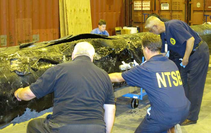
NTSB staff examine ruptured pipe
US National Transportation Safety Board staff examine a ruptured pipe from the Enbridge oil spill in August, 2010. The photo was released by the NTSB May 21, 2012. (NTSB)

The costs for Enbridge to clean up the 2010 Marshall, Michigan oil spill now far exceeds the maximum estimate that the Joint Review Panel gave for a major spill on the Northern Gateway Pipeline and also exceeds the amount of money the JRP ordered Enbridge to set aside to deal with a spill. Enbridge’s cleanup costs have also now edged past the higher liability amount requested by the Haisla Nation.

According to the US firm Enbridge Energy Partners’ filing with the United States Securities and Exchange Commission, as of September 30, 2013, the cost of cleanup was $1.035 billion US, not including possible additional fines and penalties that might be imposed by US authorities in the future.

In its decision, the Joint Review Panel estimated the cost a major oil spill from the Northern Gateway project would be about $693 million.  As part of the 209 conditions, the JRP ordered Enbridge to set aside “financial assurances” totaling $950 million.

Note all costs in this article are for a pipeline breach. The Joint Review Panel had different estimates for a tanker spill and the liability rules for marine traffic are different from pipelines.

In its filing for the third quarter of 2013, with the SEC, Enbridge Energy Partners say that the cost up until September 2013 had “exceed[ed] the limits of our insurance coverage.” The same filing says that Enbridge is in a legal dispute with one its insurers.

In its SEC filing, Enbridge says:

Lakehead Line 6B Crude Oil Release
We continue to perform necessary remediation, restoration and monitoring of the areas affected by the Line 6B crude oil release. All the initiatives we are undertaking in the monitoring and restoration phase are intended to restore the crude oil release area to the satisfaction of the appropriate regulatory authorities.
As of September 30, 2013, our total cost estimate for the Line 6B crude oil release is $1,035.0 million, which is an increase of $215.0 million as compared to December 31, 2012. This total estimate is before insurance recoveries and excluding additional fines and penalties which may be imposed by federal, state and local governmental agencies, other than the Pipeline and Hazardous Materials Safety Administration, or PHMSA, civil penalty of $3.7 million, we paid during the third quarter of 2012. On March 14, 2013, we received an order from the EPA, or the Environmental Protection Agency, which we refer to as the Order, that defined the scope which requires additional containment and active recovery of submerged oil relating to the Line 6B crude oil release. We submitted our initial proposed work plan required by the EPA on April 4, 2013, and we resubmitted the workplan on April 23, 2013. The EPA approved the Submerged Oil Recovery and Assessment workplan, or SORA, with modifications on May 8, 2013. We incorporated the modification and submitted an approved SORA on May 13, 2013. The Order states that the work must be completed by December 31, 2013.

The $175.0 million increase in the total cost estimate during the three month period ending March 31, 2013, was attributable to additional work required by the Order. The $40.0 million increase during the three month period ending June 30, 2013 was attributable to further refinement and definition of the additional dredging scope per the Order and associated environmental, permitting, waste removal and other related costs. The actual costs incurred may differ from the foregoing estimate as we complete the work plan with the EPA related to the Order and work with other regulatory agencies to assure that our work plan complies with their requirements. Any such incremental costs will not be recovered under our insurance policies as our costs for the incident at September 30, 2013 exceeded the limits of our insurance coverage.

According to the SEC filing, the breakdown of costs include $2.6 million paid to owners of homes adversely impacted by the spill.

Despite the efforts we have made to ensure the reasonableness of our estimates, changes to the recorded amounts associated with this release are possible as more reliable information becomes available. We continue to have the potential of incurring additional costs in connection with this crude oil release due to variations in any or all of the categories described above, including modified or revised requirements from regulatory agencies in addition to fines and penalties as well as expenditures associated with litigation and settlement of claims.
The material components underlying our total estimated loss for the cleanup, remediation and restoration associated with the Line 6B crude oil release include the following:
(in millions)

Response Personnel & Equipment  $454

Environmental Consultants  $193

Professional, regulatory and other $388

Total $ 1,035

For the nine month periods ended September 30, 2013 and 2012, we made payments of $62.3 million and $120.9 million, respectively, for costs associated with the Line 6B crude oil release. For the nine month period ended September 30, 2013, we recognized a $2.6 million impairment for homes purchased due to the Line 6B crude oil release which is included in the “Environmental costs, net of recoveries” on our consolidated statements of income. As of September 30, 2013 and December 31, 2012, we had a remaining estimated liability of $265.9 million and $115.8 million, respectively.

As for insurance, Enbridge Energy Partners say:

The claims for the crude oil release for Line 6B are covered by the insurance policy that expired on April 30, 2011, which had an aggregate limit of $650.0 million for pollution liability. Based on our remediation spending through September 30, 2013, we have exceeded the limits of coverage under this insurance policy. During the third quarter 2013, we received $42.0 million of insurance recoveries for a claim we filed in connection with the Line 6B crude oil release and recognized as a reduction to environmental cost in the second quarter of 2013. We recognized $170.0 million of insurance recoveries as reductions to “Environmental costs, net of recoveries” in our consolidated statements of income for the three and nine month periods ended September 30, 2012 for the Line 6B crude oil release. As of September 30, 2013, we have recorded total insurance recoveries of $547.0 million for the Line 6B crude oil release, out of the $650.0 million aggregate limit. We expect to record receivables for additional amounts we claim for recovery pursuant to our insurance policies during the period that we deem realization of the claim for recovery to be probable.

In March 2013, we and Enbridge filed a lawsuit against the insurers of our remaining $145.0 million coverage, as one particular insurer is disputing our recovery eligibility for costs related to our claim on the Line 6B crude oil release and the other remaining insurers assert that their payment is predicated on the outcome of our recovery with that insurer. We received a partial recovery payment of $42.0 million from the other remaining insurers and have since amended our lawsuit, such that it now includes only one insurer. While we believe that our claims for the remaining $103.0 million are covered under the policy, there can be no assurance that we will prevail in this lawsuit.


The Joint Review, Enbridge and Michigan

The Joint Review Panel based its finding on the Marshall, Michigan spill on the figure of $767 million from the summer of 2012 –again showing the limitations of the JRP’s evidentiary deadlines since the costs are now much higher.

The JRP quoted Enbridge as saying:

Northern Gateway considered the high costs of the Marshall, Michigan spill, which were at least $252,000 per cubic metre ($40,000 per barrel), to be an outlier or a rare event because the spill occurred in a densely populated area, because the pipeline’s response time was abnormally long, and because there was the prospect of potentially lengthy legal proceedings.

Enbridge assured the JRP that the corporate culture and management changes and equipment upgrades since the Marshall, Michigan spill lowered that chances of a similar event.

The company based its models for the JRP on much smaller spills, including one spill at Lake Wabamun, Alberta from a train not a pipeline (Vol. 2 p 357)

Enbridge’s risk assessment did not “generate an estimate of economic losses caused
by a spill.”

The JRP says Northern Gateway relied on its analysis of literature, and spill events experienced by Enbridge and other liquid hydrocarbon carriers in Alberta and British Columbia. After assessing all of this information, Northern Gateway regarded the high costs of a cleanup as “conservative”–meaning the company expects costs to be lower than its estimates in evidence before the JRP.

In Northern Gateway’s view the most costly pipeline spill incident would be a full-bore oil pipeline rupture, with an estimated cost of $200 million, and an extremely low probability of occurrence.

Haisla evidence

In their evidence, the Haisla (and other First Nations and intervenors) were doubtful about Northern Gateway’s assurances. The Haisla asked that Enbridge have a minimum of $1 billion in liability, an amount Enbridge has now exceeded in Michigan.

Haisla Nation estimated the cost of damage to ecosystem services because of a terrestrial oil spill from Northern Gateway’s pipeline would be in the range of $12,000 to $610 million for a 30-year period.

The Haisla’s cost estimates were based on values for environmental goods and services and probabilities of spills that were independent of Northern Gateway’s parameters for estimating oil spill costs. In contrast to Northern Gateway’s estimated spill frequency and costs, the Haisla predicted that spills would occur more often and placed a higher value on damages to environmental goods and services.

Haisla Nation argued that Northern Gateway overestimated its ability to detect and respond to a spill. In the Haisla’s view this resulted in the cost of a spill and the requisite financial assurances being understated. Haisla cited several factors, including: remote location, limited access, challenging terrain, seasonal conditions, and river flow conditions that would cause the cost of cleaning up a spill in the Kitimat River valley to be significantly greater than the costs associated with Enbridge’s Marshall, Michigan spill.

For these reasons, Haisla proposed that Northern Gateway should be required to obtain a minimum of $1 billion of liability coverage through insurance and financial assurances. Haisla said that Northern Gateway should file annually the report from an independent third party assessing the financial assurances plan. (Vol 2 p359)

In response Northern Gateway said:

Northern Gateway said that Haisla’s findings were based on a number of fundamental methodological flaws and a lack of probability analysis to support the high frequency of occurrence of oil spill events. Northern Gateway argued that Haisla’s estimates of ecosystem service values were inflated because they were based on values from unrelated studies. In Northern Gateway’s view, Haisla relied on high passive use values that were not justified.

JRP ruling

As it has in most of its decision, the JRP accepted Northern Gateway’s evidence, including its explanation of the Marshall, Michigan spill and then went on to base its spill cost estimates not on a pipeline breach but on the 2005 railway spill at Lake Wabumum, near White Sands, Alberta.

The Panel accepts that the cleanup costs for the Marshall, Michigan spill were orders of magnitude higher because of the extended response time. In this application, the Panel accepts Northern Gateway’s commitment to complete the shutdown in no more than 13 minutes after detection. For this reason the Panel did not use the Marshall spill costs in its calculations. The spill volume and the resulting costs are directly dependent on the Northern Gateway’s control room staff and the pipeline control system fully closing the adjacent block valves no longer than 13 minutes from the detection of an alarm event, as well as the amount of oil which would drain out of the pipeline after valve closure due to elevation differences.

The Panel decided on a total unit cost of $138,376 per cubic metre ($22,000 per barrel). This is midway between the unit cost of $88,058 per cubic metre ($14,000) per barrel proposed by Northern Gateway and the unit cost of $188,694 per cubic metre ($30,000 per barrel) for the Lake Wabamun spill. It is about one-half of the Marshall spill’s unit cost. Giving weight to the Lake Wabamun costs recognizes actual costs experienced in a Canadian spill and the greater costs of spills in high consequence areas. In these areas, individuals, populations, property, and the environment would have a high sensitivity to hydrocarbon spills. The deleterious effects of the spill would increase with the spill volume, the extent of the spill, and the difficulty in accessing the spill area for cleanup and remediation.

Using these spill volume and unit cost values in the calculation below, the Panel estimated the total cost of a large spill could be $700 million. Total cost of a spill = 31,500 barrels x $22,000 per barrel = $693 million, or $700 million when rounded up.

(p362)

The Panel based the financial assurances requirements for Northern Gateway on a spill with a total estimated cost of $700 million and directs Northern Gateway to develop a financial assurances plan with a total coverage of $950 million that would include the following components:
i. Ready cash of $100 million to cover the initial costs of a spill;
ii. Core coverage of $600 million that is made up of stand-alone, third party liability insurance and other appropriate financial assurance instruments, and
iii. Financial backstopping via parental, other third party guarantees, or no fault insurance of at least $250 million to cover costs that exceed the payout of components i. and ii.
The financial backstopping would be available to fill the gap if the spill volumes or unit costs were under-estimated or if the payout from the core coverage would be less than 100 per cent.

The Panel noted that:

The evidence indicates that there is some probability that a large oil spill may occur at some time over the life of the project. In these circumstances the Panel must take a careful and precautionary approach because of the high consequences of a large spill. The Panel has decided that Northern Gateway must arrange and maintain sufficient financial assurances to cover potential risks and liabilities related to large oil spills during the operating life of the project.

Northern Gateway committed to investing $500 million in additional facilities and mitigation measures such as thicker wall pipe, more block valves, more in-line inspections, and complementary leak detection systems. This initiative should enhance the safety and reliability of the system and help reduce and mitigate the effects of a spill, but it would not eliminate the risk or costs of spills. This initiative is not a direct substitute for third party liability insurance and does not eliminate the need for liability insurance or any other form of financial assurance to cover the cost of a spill. (p 361)

So the JRP decision comes down to this, if you accept Northern Gateway’s position that pipeline spills are rare and mostly small, then the company has the financial resources to cover the damage. If, however, Northern Gateway is wrong and the costs of a pipeline cleanup exceed the $950 million required by the Joint Review Panel, as has happened in Michigan, then those JRP conditions are already obsolete.

(Northwest Coast Energy News encourages all readers to read the complete JRP report  and SEC filing since space and readability does not permit fully quoting from the report)

How Gateway’s plans to dredge Douglas Channel show the limitations of the JRP mandate and ruling

(First in series of reports on how the Joint Review Panel report will affect the Kitimat region)

JRP map of blasting on Douglas Channel
Joint Review map of Northern Gateway plans for dredging and blasting on Douglas Channel (JRP)


If there is a significant flaw in the Joint Review Panel report on Northern Gateway, it can be found in the panel’s analysis of Enbridge Northern Gateway’s plans to blast and dredge at the proposed Kitimat terminal site.

While the Joint Review Panel does consider what it calls “cumulative effects,” the panel plays down those effects and offers no specifics about interaction between the Northern Gateway project and the two liquified natural gas projects, the KM LNG project at Bish Cove and the BC LNG floating terminal at the old log dump.

It appears the JRP considered the legacy effects of the Rio Tinto Alcan smelter and other Kitimat industries while not taking into consideration future development.

The dredging and blasting planned by Northern Gateway, as Enbridge said in its evidence,  appears to have only a minimal effect on Douglas Channel.

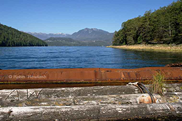
A glance at the map in the Joint Review ruling shows that that the dredging and blasting site is directly opposite Clio Bay, where Chevron, in partnership with the Haisla Nation, plan a remediation project using marine clay from the Bish Cove construction site to cap decades of sunken and rotting logs.

The Clio Bay project was not part of the evidence before the Joint Review Panel, the plans for the project were not formulated until well after the time for evidence before the JRP closed. But those deadlines show one area where the rules of evidence and procedure fail the people of northwestern BC.

The JRP is a snapshot in time and changes in the dynamics of the industrial development in the Kitimat Arm are not really considered beyond the terms of reference for the JRP.

It appears from the report that Enbridge plans to simply allow sediment from the blasting and dredging to float down Douglas Channel, dispersed by the currents and the outflow from the Kitimat River.

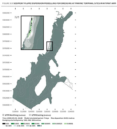
Northern Gateway said that dredging and blasting for marine terminal construction would result in a sediment plume that would extend over an area of 70,000 square metres for the duration of blasting activities.

Approximately 400 square metres of the assessed area of the marine terminal is expected to receive more than 1 centimetre of sediment deposition due to dredging. Outside of this area, typical sediment deposition levels alongshore where sediment is widely dispersed (a band approximately 4 kilometres long and 400 metres wide) are very low; in the range of 0.001 to 0.1 centimetres. Dredging and blasting activities are expected to occur over a period of approximately 18 weeks.

Northern Gateway expected most of the sediment plume created by construction activities to be minor in relation to natural background levels.

Northern Gateway would use bubble curtains to reduce pressure and acoustic effects of blasting, and silt curtains to reduce the effect of sedimentation from dredging. It said that bubble curtains are used extensively for other activities, such as pile driving, to reduce the effect of high pressure pulses that can cause injury to fish.

It added that bubble curtains have been tested extensively with blasts, and literature shows they are effective.

Northern Gateway said that physical effects from suspended sediment on marine fish and invertebrates could include abrasion and clogging of filtration mechanisms, which can interfere with ingestion and respiration. In extreme cases, effects could include smothering, burial, and mortality to fish and invertebrates. Direct chemical-related effects of suspended sediment on organisms, including reduced growth and survival, can also occur as a result of the uptake of contaminants
re-suspended by project construction activities, such as dredging and blasting, and as a result ofstorm events, tides, and currents.

The Haisla Nation and Raincoast Conservation objected to Northern Gateway’s figures, noting

Northern Gateway’s sediment and circulation model and its evidence related to contaminated sediment re-suspension at the terminal site. Both parties said that the sediment model was applied for the spring, when the increase in total suspended solids would be negligible compared to background values. In the event of delays, blasting and dredging would likely occur at other times of the year when effects would likely be higher, and these scenarios were not modelled.

The panel’s assessment of the area to be blasted found few species:

Species diversity within Kitimat Arm’s rocky intertidal community is generally low. Barnacles, mussels, periwinkles, and limpets can be found on rocky substrate. Sea urchins, moon snails, sea anemones, sea stars, and sea cucumbers are in shallow subtidal areas. Sandy areas are inhabited by commercially-harvested bivalves such as butter clams and cockles.

Northern Gateway told the JRP that it would “offset” any damage to Douglas Channel caused by the blasting and dredging

Northern Gateway said that construction, operations, and decommissioning of the marine terminal would result in both permanent and temporary alteration of marine fish habitat. Dredging and blasting, and installing physical structures in the water column for the marine terminal would permanently alter marine fish habitat. Based on the current terminal design, in-water site preparation would result in the physical alteration of approximately 1.6 hectares of subtidal marine habitat and 0.38 hectares of intertidal marine habitat. Northern Gateway expected approximately 353 square metres of subtidal marine habitat and 29 square metres of intertidal habitat to be permanently lost.This habitat would be compensated for by marine habitat offsets.

The project’s in-water vertical structures that would support the mooring and berthing structures could create new habitat, offsetting potential adverse effects. The structures may act as artificial reefs, providing marine fish habitat, food, and protection from predation. Although organisms currently inhabiting the work area would be killed, the exposed bedrock would be available for colonization as soon as the physical works are completed.

In its finding on marine sediment, the panel, as it does throughout the ruling, believes that the disruption to the environment caused by previous and ongoing human activity, means that the Northern Gateway Kitimat terminal won’t make that much difference.

Sediment quality in the marine environment is important because sediment provides habitat for benthic aquatic organisms. Northern Gateway’s baseline data for the area immediately surrounding the marine terminal indicated some contamination of water, sediments, and benthic organisms from previous industrial activity. Industrial activities in the Kitimat area have released contaminants through air emissions and effluent discharges since the 1960s. Sources of contaminants to Kitimat Arm
include effluent from a municipal wastewater treatment plant, the Alcan smelter, Methanex Corporation’s methanol plant, and the Eurocan pulpmill, as well as storm water runoff from these operations and the municipality.

Area is largely controlled by natural outflow from the Kitimat River with suspended sediment levels being highest during peak river runoff (May to July, and October) and lowest during winter. Storm events, tides, and currents can also suspend sediments. Levels of total suspended solids fluctuate seasonally and in response to climatic variations, but are generally highest during the summer.

Commercial and recreational vessels currently operating in the area may increase suspended solids by creating water turbulence that disturbs sediments. Given the current sediment contamination levels and the limited area over which sedimentation from construction activities would be expected to disperse, the Panel finds that the risk posed by disturbed contaminated sediment is low. Northern Gateway has committed to monitoring during construction to verify the predicted effects on sediment and water quality for both contaminants and total suspended solids..

The dredging and blasting section of the Joint Review Report is small when compared to the much more extensive sections on pipeline construction and tanker traffic, and the possible effects of a catastrophic oil spill.

Although minor, the marine sediment section exposes the question that was never asked, given the disruptions from years of log dumping at Clio Bay and Minette Bay and the decades of  developments at the mouth of the Kitimat River, and future development from LNG, when do cumulative effects begin to overwhelm? How much is enough? How much is too much? If every project continues to be viewed in isolation, what will be left when every project is up and running?


Clio Bay: Clay capping “relatively new technique”: DFO statement

Carrie Mishima, a communications advisor for the Department of Fisheries and Oceans sent this statement in response to questions from Northwest Coast Energy News:

· The proposal by the Kitimat LNG project uses a relatively new technique that is expected to improve aquatic habitat in Clio Bay. The bay has been used as a log handling site for decades, resulting in areas of degraded habitat from woody debris on the seafloor. The project will cap impacted areas with inert material to restore the seafloor.

· Capping at smaller-scale sites in Canada has shown that the technique has successfully restored low-value aquatic habitat.

· The project will implement standard and project-specific measures to protect fish and aquatic habitat and will conduct a five-year monitoring program to determine how well the habitat is recovering.

· Data from the monitoring program will be used to guide future habitat reclamation at impacted habitat sites. Reference sites are being established as benchmarks against which the capped sites can be measured.

· Site-specific standards for dissolved oxygen levels will be developed for the enhanced site by sampling a control site having similar habitat parameters.

· Detailed mapping has been done to identify the best areas for the soil placement and to protect sensitive habitat such as intertidal areas, rocky substrates and eelgrass beds.
· Other required mitigation measures will include analyzing the cap material to confirm it is free of contaminants and placing this material during appropriate tidal conditions to ensure accurate placement of the cap in accordance with design plans.

[rps-include post=5057]

Special report: Clio Bay cleanup: Controversial, complicated and costly

Special report: Clio Bay cleanup: Controversial, complicated and costly

Log booming at Clio Bay
Log booming operations at Clio Bay, August 21, 2013. (Robin Rowland/Northwest Coast Energy News)

Chevron, the company operating the KM LNG project at Bish Cove and the Haisla Nation have proposed that marine clay from the Bish Cove construction site be used to cap more than 10,000 sunken and rotting logs in Clio Bay. Haisla Chief Counsellor Ellis Ross says he hopes that using clay to cover the logs will help remediate the environmentally degrading sections of the Bay. The proposal has brought heated controversy over the plan, both among residents of Kitimat and some members of the Haisla Nation, who say that Clio Bay is full of life and that the capping will cause irreparable damage.

An investigation by Northwest Coast Energy News shows that capping thousands of sunken logs is a lot more complicated and possibly costly than anyone has considered. It is also clear that many of the comments both supporting and opposing the Clio Bay project are based on guesses rather than the extensive scientific literature available on the subject.

Northwest Coast Energy News findings include:

  • In 1997, the Department of Fisheries and Oceans surveyed sunken log sites in Douglas Channel. The results, published in 2000, identified 52 sites just on Douglas Channel and the Gardner Canal that had various levels of enviromental degradation due to sunken logs. Clio Bay was not the list. The DFO scientists recomended followup studies that never happened.
  • Scientific studies show that degradation from sunken logs can vary greatly, even within one body of water, due to depth, currents, number of logs, and other factors. So one part of a bay can be vibrant and another part environmentally degraded due to low levels of dissolved oxygen and decaying organic material.
  • If  KM LNG wasn’t paying for the remediation of Clio Bay, it could be very expensive. Capping sunken logs at a cove near Ketchikan, Alaska, that is the same size and shape as Clio Bay cost the US and Alaska governments and the companies involved $2,563,506 in 2000 US dollars. The total cost of the cleanup of the site which was also contaminated with pulp mill effluent was $3,964,000. The estimated cost of capping the logs in the Alaska project was $110 per cubic yard.
  • The Alaska project shows that a remediation project means while most of the logs in a bay or cove can be capped, in some parts of a water body, depending on currents, contamination and planned future use, the logs have to be removed and the area dredged.
  • Agencies such as the State of Alaska, the US Environmental Protection Agency and the US Army Corps of Engineers all recommend using “clean sand” for capping operations. Although “clay balls” have been used for capping in some cases, the US officials contacted say they had no record of large amounts of marine clay ever being used for capping. They also noted that every log capping project they were aware of happened in sites that had other forms of contamination such as pulp mill effluent.
  • Chevron only recently retained the environmental consulting firm Stantec to study Clio Bay. The Department of Fisheries and Oceans has told District of Kitimat Council it recently completed mapping of the seafloor at Clio Bay. The Alaska project was preceded by five years of monitoring and studies before capping and cleanup began.
  • A letter from Fisheries and Oceans to the District of Kitimat says that Clio Bay has been mapped and the department is planning to monitor any capping operations. However, it appears from the Department of Fisheries and Oceans website that the department has no current policies on remediation since the Conservative government passed two omnibus which weakened the country’s environmental laws. According to the website, new remediation policies are now being drafted. That means that although DFO will be monitoring the Clio Bay operation, it is uncertain what standards DFO will be using to supervise whatever happens in Clio Bay.

Northwest Coast Energy News is continuing its investigation of the sunken logs problem.  Expect more stories in the days to come.

[rps-include post=5057]

Clio Bay: Haisla desire to clean up bay led to proposal to cap Clio with marine clay, Ross says

Special report: Clio Bay cleanup: Controversial, complicated and costly

Clio Bay
Clio Bay, looking toward Douglas Channel, September 14, 2013. (Robin Rowland/Northwest Coast Energy News)


Haisla First Nation Chief Counsellor Ellis Ross says the Haisla made the proposal to the KM LNG project, a partnership of Chevron and Apache, to use the marine clay to cover the thousands of logs at the bottom of Clio Bay after years frustration with the Department of Fisheries and Oceans and the BC provincial government, which for decades ignored requests for help in restoring almost fifty sunken log sites in Haisla traditional territory.

The problem is that remediation of the hundreds of sites on Canada’s  west coast most containing tens of thousands of sunken logs has been so low on DFO’s priority list that even before the omnibus bills that gutted environmental protection in Canada, remediation of sunken log sites by DFO could be called no priority.

Now that the KM LNG has to depose of a total of about 3.5 million cubic metres of marine clay and possibly other materials from the Bish Cove site, suddenly log remediation went to high priority at DFO.

The controversy is rooted in the fact that although the leaders of the Haisla and the executives at Chevron knew about the idea of capping Clio Bay, people in the region, both many residents of Kitimat and some members of the Haisla were surprised when the project was announced in the latest KM LNG newsletter distributed to homes in the valley.

Chevron statement

In a statement sent to Northwest Coast Energy News Chevron spokesperson Gillian Robinson Ridell said:

The Clio Bay Restoration Project  proposed by Chevron, is planned to get underway sometime in early 2014. The proposal is fully supported by the Federal Department of Fisheries and Oceans and the Haisla First Nation Council.  The project has been put forward as the best option for removal of the marine clay that is being excavated from the Kitimat LNG site at Bish Cove. Chevron hired Stantec, an independent engineering and environmental consulting firm with extensive experience in many major habitat restoration projects that involve public safety and environmental conservation.  The Haisla, along with Stantec’s local marine biologists, identified Clio Bay as a site that has undergone significant environmental degradation over years of accumulation of underwater  wood debris caused by historic log-booming operations. The proposal put forward by the marine biologists was that restoration of the marine ecosystem in the Bay could be achieved  if marine clay from Chevron’s facility site, was used to cover the woody debris at the bottom of the Bay. The process outlined by the project proposal is designed to restore the Clio Bay seafloor to its original soft substrate that could sustain a recovery of biological diversity.

Kitimat worried

Non-aboriginal residents of Kitimat are increasingly worried about being cut off from both Douglas Channel and the terrestrial back country by industrial development. These fears have been heightened by reports that say that Clio Bay could be closed to the public for “safety reasons” for as much as 16 months during the restoration project.

The fact that Clio is known both as a safe anchorage during bad weather and an easy to get to location for day trips from Kitimat has made those worries even more critical.

There is also a strong feeling in Kitimat that the residents were kept out of the loop when it came to the Clio Bay proposal.

In a letter to the District of Kitimat, DFO said:

Clio Bay has been used as a log handling site for decades which has resulted in areas of degraded habitat from accumulations of woody debris materials on the sea floor. The project intends to cap impacted areas with inert materials and restore soft substrate seafloor. The remediation of the seafloor is predicted to enhance natural biodiversity and improve the productivity of the local fishery for Dungeness crab. The project area does support a variety of life that will be impact and therefore the project will require authorization from Fisheries and Oceans Canada for the Harmful Alteration, Disruption or Destruction (HADD) of fish and fish habitat.

The letter avoids the controversy over the use of marine clay but saying “inert material” will be used. That can only increase the worries from residents who say that not only clay but sand, gravel and other overburden from Bish Cove and the upgrade of the Forest Service Road may be used in Clio Bay. (The use of “inert material” also gives DFO an out if it turns out the department concludes the usual practice of using sand is better. That, of course, leaves the question of what to do with the clay).

Although Ellis Ross has said he wants to see large numbers of halibut and cod return to Clio Bay, the DFO letter only mentions the Dungeness Crab.

DFO website cites pending changes after the passage of the omnibus bills.

Try to search “remediation” on the DFO site and the viewer is redirected to a page that cites the omnibus bills passed by the Conservative government and says

On June 29, 2012, the Fisheries Act was amended. Policy and regulations are now being developed to support the new fisheries protection provisions of the Act (which are not yet in force). The existing guidance and policies continue to apply. For more information, see Changes to the Fisheries Act.

On April 2nd, 2013 the Habitat Management Program’s name was changed to the Fisheries Protection Program.

So, despite what communications officers for DFO and the Harper government may say, there was no policy then and there is no policy now on remediation of log sites. Given Harper’s attitude that LNG and possibly bitumen export must proceed quickly with no environmental barriers, it is likely that environmental remediation will continue to be no priority—unless remediation becomes a problem that the energy giants have to solve and pay for.

Alaska studies

On the other hand, the State of Alaska and the United States Environmental Protection Agency spent a decade at a site near Ketchikan studying the environmental problems related to sunken logs at transfer sites

Those studies led Alaska to issue guidelines in 2002 with recommended practices for rehabilitating ocean log dump sites and for the studies that should precede any remediation project.

The Alaska studies also show that in Pacific northwest coast areas, the ecological effects of decades of log dumping, either accidental or deliberate, vary greatly depending on the topography of the region, the topography of the seabed, flow of rivers and currents as well as industrial uses along the shoreline.

The Alaska policy is based on studies and a remediation project at Ward Cove, which in many ways resembles Clio Bay, not far from Kitimat, near Ketchikan.

The Alaska policy follows guidelines from both the US Environmental Protection Agency and the US Army Corps of Engineers that recommend using thin layers of “clean sand” as the best practice method for capping contaminated sites. (The Army Corps of Engineers guidelines say that “clay balls” can be used to cap contaminated sites under some conditions. Both a spokesperson for the Corps of Engineers and officials at the Alaska Department of Environmental Conservation told Northwest Coast Energy News that they have no records or research on using marine clay on a large scale to cap a site.)

The EPA actually chose Sechelt, BC, based Construction Aggregates to provide the fine sand for the Ward Cove remediation project. The sand was loaded onto 10,000 tonne deck barges, hauled up the coast to Ward Cove, offloaded and stockpiled then transferred to derrick barges and carefully deposited on the sea bottom using modified clam shell buckets.

The EPA says

Nearly 25,000 tons of sand were placed at the Ward Cove site to cap about 27 acres of contaminated sediments and 3 other acres. In addition, about 3 acres of contaminated sediments were dredged in front of the main dock facility and 1 acre was dredged near the northeast corner of the cove. An additional 50 acres of contaminated sediments have been left to recover naturally.

A report by Integral Consulting, one of the firms involved at the project estimated that 17,800 cubic metres of sand were used at Ward Cove.

In contrast, to 17,800 cubic metres of sand used at Ward Cove, the Bish Cove project must dispose of about 1.2 million cubic metres of marine clay at sea (with another 1.2 million cubic metres slated for deposit in old quarries near Bees Creek).

Studies at Ward Cove began as far back as 1975. In 1990 Alaska placed Ward Cove on a list of “water-quality limited sites.” The studies intensified in 1995 after the main polluter of Ward Cove, the Ketchikan Paper Company, agreed in a consent degree on a remediation plan with the Environmental Protection Agency in 1995. After almost five years of intensive studies of the cove, the sand-capping and other remediation operations were conducted from November 2000 to March 2001. A major post-remediation study was carried out at Ward Cove in 2004 and again in 2009. The next one is slated for 2015.

Deaf ears at DFO

“We need to put pressure on the province or Canada to cleanup these sites. We’ve been trying to do this for the last 30 years. We got nowhere,” Ellis Ross says. “Before when we talked [to DFO] about getting those logs and cables cleaned up, it fell on deaf ears. They had no policy and no authority to hold these companies accountable. So we’re stuck, we’re stuck between a rock and hard place. How do we fix it?”

Ross says there has been one small pilot project using marine clay for capping which the Haisla’s advisers and Chevron believe can be scaled up for Clio Bay.

Douglas Channel studies

The one area around Kitimat that has been studied on a regular basis is Minette Bay. The first study occurred in 1951, before Alcan built the smelter and was used as a benchmark in future studies. In 1995 and 1996, DFO studied Minette Bay and came to the conclusion that because the water there was so stagnant, log dumping there had not contributed to low levels of dissolved oxygen although it said that it could not rule out “other deleterious effects on water quality and  habitat`from log dumping.”

That DFO report also says that there were complaints about log dumping at Minette Bay as far back as 1975, which would tend to confirm what Ross says, that the Haisla have been complaining about environmentally degrading practices for about 30 years.

Ross told Northwest Coast Energy News that if the Clio Bay remediation project is successful, the next place for remediation should be Minette Bay.

A year after the Minette Bay study, DFO did a preliminary study of log transfer sites in Douglas Channel, with an aerial survey in March 1997 and on water studies in 1998. The DFO survey identified 52 locations with sunken logs on Douglas Channel as “potential study sites.” That list does not include Clio Bay. On water studies were done at the Dala River dump site at the head of the inlet on Kildala Arm, Weewanie Hotsprings, at the southwest corner of the cove, the Ochwe Bay log dump where the Paril River estuary opens into the Gardner Canal and the Collins Bay log dump also on the Gardner Canal.

In the introduction to its report, published in 2000, the DFO authors noted “the cumulative effect of several hundred sites located on BC coast is currently unknown.”

DFO list of sunken log sites on Douglas Channel   (pdf)

Since there appears to have been no significant follow-up, that cumulative effect is still “unknown.”

In 2000 and 2001, Chris Picard, then with the University of Victoria, now Science Director for the Gitga’at First Nation did a comparison survey of Clio Bay and Eagle Bay under special funding for a “Coasts Under Stress” project funded by the federal government. Picard’s study found that Eagle Bay, where there had been no log dumping was in much better shape than Clio Bay. For example, Picard’s study says that “Dungeness crabs were observed five times more often in the unimpacted Clio Bay.”

Although low oxygen levels have been cited as a reason for capping Clio Bay, Picard’s study says that “near surface” oxygen levels “did not reliably distinguish Clio and Eagle Bay sediments.” While Clio Bay did show consistent low oxygen levels, Eagle Bay showed “considerable interseasonal variation” which is consistent with the much more intensive and ongoing studies of oxygen levels at Wards Cove.

Chevron’s surprise

It appears that Chevron was taken by surprise by the controversy over the Clio Bay restoration. Multiple sources at the District of the Kitimat have told Northwest Coast Energy News that in meetings with Chevron, the company officials seemed to be scrambling to find out more about Clio Bay.

This is borne out by the fact, in its communications with Northwest Coast Energy News, Chevron says its consulting firm, Stantec has cited just two studies, Chris Picard’s survey of Clio Bay and a 1991 overview of log-booming practices on the US and Canadian Pacfic coasts. So far, Chevron has not cited the more up-to-date and detailed studies of Ward Cove that were conducted from 1995 to 2005.

Chevron says that Stantec marine biologists are now conducting extensive field work using divers and Remote Operated Vehicle surveys to “observe and record all flora and fauna in the bay and its levels of abundance. Stantec’s observations echoed the previous studies which determined that the massive amount of wood has harmed Clio Bay’s habitat and ecosystem.”

In its statement to Northwest Coast Energy News, Chevron cited its work on Barrow Island,  in Western Australia, where the Chevron Gordon LNG project is on the same island as a highly sensitive ecological reserve. Chevron says the Australian site was chosen only after a thorough assessment of the viability of other potential locations, and after the implementation of extensive mitigation measures, including a vigorous quarantine program for all equipment and materials brought on to the Barrow island site to prevent the introduction of potentially harmful alien species.

Reports in the Australian media seem to bare out Chevron’s position on environmental responsibility. Things seem to be working at Barrow Island.

Robinson went on to say:

Those same high environmental standards are being applied to the Kitimat LNG project and the proposed Clio Bay Restoration project. The proposed work would be carried out with a stringent DFO approved  operational plan in place and would be overseen by qualified environmental specialists on-site.

The question that everyone in the Kitimat region must now ask is just how qualified are the environmental specialists hired by Chevron and given staff and budget cuts and pressure from the Prime Minister’s Office to downgrade environmental monitoring just how stringent will DFO be monitoring the Clio Bay remediation?

Alaska standardsIn the absence of comprehensive Canadian studies, the only benchmark available is that set by Alaska which calls for:Capping material, typically a clean sand, or silty to gravelly sand, is placed on top of problem sediments. The type of capping material that is appropriate is usually determined during the design phase of the project after a remediation technology has been selected. Capping material is usually brought to the site by barge and put in place using a variety of methods, depending on the selected remedial action alternative.

Thick Capping

Thick capping usually requires the placement of 18 to 36 inches of sand over the area. The goal of thick capping is to isolate the bark and wood debris and recreate benthic habitat that diverse benthic infauna would inhabit.

Thin Capping

Thin capping requires the placement of approximately 6 – 12 inches of sand on the project area. It is intended to enhance the bottom environment by creating new mini-environments, not necessarily to isolate the bark and wood debris. With thin capping, surface coverage is expected to vary spatially, providing variable areas of capped surface and amended surface sediment (where mixing between capping material and problem sediment occurs) as well as limited areas where no cap is evident.

Mounding

Mounding places small piles of sand or gravel dispersed over the waste material to create habitat that can be colonized by organisms. Mounding can be used where the substrate will not support capping.

[rps-include post=5057]

Clio Bay remediation project “killing two birds with one stone,” Ross says

Special report: Clio Bay cleanup: Controversial, complicated and costly


Ellis Ross
Haisla Nation Chief Counsellor Ellis Ross at Bish Cove, June 19, 2013. (Robin Rowland/Northwest Coast Energy News)

Haisla Chief Counsellor Ellis Ross says that capping the logs at Clio Bay was a Haisla idea, taking advantage of the opportunity to use the marine clay from Bish Cove to bring back the Clio ecosystem.

The Haisla were told by experts who video taped the bottom of Clio Bay that are between 15,000 to 20,000 sunken logs in Clio Bay.

“I know because I’ve spent a lot of time down there plus my dad actually worked for the booming company for years and knew what was going on out there,” Ross said. “There are two extreme areas we’re talking about, if you look at Clio Bay where it’s estimated that there 15,000 to 20,000 logs down there, imagine what Minette Bay looks like? And it’s all iron, it’s steel. It’s not just wood, there are a lot of cables down there.

Retrieved cables
Cables retrieved from Ward Cove, Alaska, during dredging and capping in 2001. (EPA)

“The Haisla have known about the degradation of our territory for years. The problem we have as Haisla members is to restore the habitiat is that nobody wants to clean up the habitat. This was our idea, after review from technical experts from DFO as well as our own experts. We’re looking for a three way solution, with the company, DFO and the Crown and the Haisla.”

“I’d love to go and catch halibut and cod, like my ancestors used to.”

He said that the Haisla have beem aware of environmental problems from sunken logs for decades and have been asking for cleanup of degraded areas since 2004, not just at Clio Bay, but in the Kildala Arm and at Collins Bay, which were studied by DFO in 1997.

“The logs are down there, they are oxidizing, but no one wants to do anything about it, including the company and including the Crown. We had independent people come in and review it and have them come up with a recommendation. There was a small scale project [involving marine clay] that proved that this could work.

“This system here is killing two birds with one stone, get rid of the clay and try to remediate some of the habitat,” Ross said.

He said that the original estimate of marine clay excavated at Bish Cove was 10,000 cubic metres. That has now risen to about 3.5 million cubic metres because the KM LNG project is digging deeper for the foundation of the LNG terminal. The original plan called for disposing 1.2 million cubic metres at sea and another 1.2 million cubic metres on land.

“The original idea was to dump the clay in the middle of the ocean. In small amounts it could have been mitigated, but in large amounts we said ‘no.’ If we try to dump clay in the middle of the channel, we have no idea where it’s going to end up, what the effect is going to be.” Ross said. “We did the same thing here for the terrestrial side, we said ‘OK that with the rock quarries above Bees Creek,’ use the clay to help remediate that as well, bring it back.”

Asked about Ward Cove in Alaska, where the US Environmental Protection Agency ordered a cleanup, Ross said. “The difference here is that no one is ordering these companies to clean up the sites, they walk away. No one is taking responsiblity, The Haisla are trying to do this within the parameters they’ve given us.So if someone could come in and order these companies and do something, we’ll look for something else to do with the clay. Until that day comes, the Haisla are still stuck with trying to bring back this land by ourselves. If the District of Kitimat wants to pay the bill, great. Let’s see it.

“We need to put pressure on the province or Canada to cleanup these sites. We’ve been trying to do this for the last 30 years. We got nowhere. Before when we talked about getting those logs and cables cleaned up, it fell on deaf ears [at DFO]. They [DFO] had no policy and no authority to hold these companies accountable. So we’re stuck, we’re stuck between a rock and hard place. How do we fix it?”

Ross also noted that Shell’s LNG Canada project also faces remediation problems, “Shell is going to have the same problem, their’s is going to be different, they’re going to have get rid of contamination on the ocean bottom and beneath that it’s basically going to be gravel, it’s not clay, they’re going to have get rid of that product.”

[rps-include post=5057]

Clio Bay: What happens to sunken logs?

Special report: Clio Bay cleanup: Controversial, complicated and costly

Logs at Clio Bay
Floating logs at Clio Bay, September 14, 2013. (Robin Rowland/Northwest Coast Energy News)

The forest industry has been operating on the Pacific coast from Oregon to Alaska for more than a century. Over that time, it is likely that millions of logs from booms and other operations have sunk to the bottom of bays, cove, estuaries and inlets along the coast.

During that century, scientists in both Canada and the United States have been studying the effects of the those sunken logs on the sea bottom. It is only in recent years that the cumulative effect of all those logs has become an environmental concern.

As well as logs on the sea bottom, ranging, depending on location, from a couple of hundred to the tens of thousands of logs, there are wood chips, wood fibre and discarded log parts and bark. Often metal cables, bolts, ropes, and other manufactured material either dropped accidentally or deliberately discarded are also found among the old logs, further contaminating the seabed. Compounding the problem of the sea bottom is organic material that would occur naturally on the seabed, including tree trunks, roots, branches, conifer needles, deciduous leaves and other material from terrestrial plants.

Anyone who sails Douglas Channel after a storm can see with all the floating tree trunks in the Channe. That means that storms and spring run off ads debris to the natural pile up of old logs and debris. At logging sites, this natural material, brought in by creeks and rivers, piles up on the already sunken logs.

Over the years, depending on the salinity, teredos, more popularly known as ship worms  eat the wood, often leaving a tube of bark that eventually collapses. The rotting wood, bark and other material is often, depending on conditions, pounded into fragments by the action of waves, currents and outflow from rivers. Some species of teredo can live in brackish water, but since teredos are not a fresh water species, that means that logs in fresh or mostly fresh water last longer.

A DFO report on sunken log sites on Douglas Channel, published in 2000, noted:

very few comprehensive, quantitative field studies describing the effects of wood and bark have been published and those that did focused on log handling and storage sites which handled high volumes of more than one million cubic metres.

The DFO report said that thick bark and wood debris deposits resulting from log handling can cause substantial, long-term negative impacts to benthic (sea bottom) ecosystems. Under the worst conditions, the cumulative debris can deprive an area of oxygen and, according to DFO, “virtually eliminate aerobic” sea bottom animal life.

The report noted that studies had shown that “negative biological impacts were localized,” but added that “the cumulative effect of several hundred sites located on the B.C. coast is currently unknown.”

Studying the problem has been a low priority for DFO and other agencies and that meant a limited budget and few studies. Other problems is that, according to the DFO, parts of BC fjords are steep and “much of the likely impacted habitat is beyond diver range.” There is also pressure to study the effect on “economically or socially important species.” Although the use of remotely operated vehicles has increased since the 2000 report, using an ROV can also be a budget buster for a low priority project.

As the ready timber supply in British Columbia particularly old growth forest declined in the last part of the twentieth century, the DFO report says “forest companies have harvested areas where access is more difficult and cut-blocks are smaller.” That meant many smaller dump sites were developed that were used for only one to five years. Plans for log handling at the time, DFO said, were evolving to ensure ensure that fisheries resources and overall fish production capability were not adversely affected by development of log handling facilities and planning was focused on ensuring that sites for log handling facilities did “not have sensitive fish habitats or fisheries resources (such as eel grass beds or shellfish resources) which may be affected by the log handling,”

One of the reasons for the disagreements over Clio Bay is that while some people call it “dead” saying there are no halibut and fewer cod, others say that Clio Bay is very much alive, pointing out that it is easy to catch crab and rock cod.

The studies that have looked at life on the bottom of log dumps sites have shown that it can be highly variable even within one bay or cove, with many factors creating small local ecosystems, including depth, nature of the sea bottom, for example sand, mud, clay or a mixture, whether or not the sea bottom sediment is “enriched,” the flow of currents, fresh water flow into the site, the percentage of wood on the bottom, the percentage of bark on the bottom, whether the wood and/or bark debris is “continuous’ or “discontinuous,” whether or not the seabed is contaminated as was the case with the cleanup of pulp mill sites at Ward Cove and Sitka, Alaska.

Ward Cove had been so polluted for decades by pulp mill effluent that it was eligible for US Superfund clean up funding and was estimated to hold 16,000 sunken logs. At the same time, an EPA report on Ward Cove noted that at the point Ward Creek emptied into Ward Cove was “a popular sport fishing location during salmon season, including commercially guided fishing. Some sport fishing and personal-use crab pot fishing has taken place in the past and may continue in the waters of the cove.” At the same time of the cleanup, the EPA identified that the degradation of Ward Cove put at risk eight species of salmon, 75 “non-salmonid esturine and marine fish species and benthic invertebrate fauna.”  (The EPA says Ward Cove is recovering after the reclamation and fishing is continuing)

In other words, those say Clio Bay is in danger and those who say Clio Bay is a rich source of life are likely both right.

For example, while Chris Picard’s (then with the University of Victoria, now with the Gitga’at First Nation) study of Clio Bay said: “Dungeness crabs were observed five times more often in the unimpacted Eagle Bay than in Clio Bay,” and tied that to log dumping and low oxygen.
Picard’s study noted that both Dungeness crabs and sunflower seastars, while more abundant in Eagle Bay, in Clio Bay “both species were several-fold less abundant in wood-dominated habitats in Clio Bay than in non-wood habitats in that bay.”

Several people have pointed out that since Clio Bay is one of the closest crabbing spots to both Kitimat and Kitamaat Village, while Eagle Bay is further down Douglas Channel, overfishing at Clio may be a factor in the reported species decline.

The DFO study noted

The dumping of logs into water down skids can result in the generation of a considerable amount of bark and wood debris. The abrasive action of boom boats and waves during the sorting and storage of bundles can also generate quantities of wood debris. Bark and wood lost during dumping often forms thick, continuous, anoxic fibre mats extended from the base of the dump skids. The debris mat tends to dissipate with distance from the entry point; however, wood debris can often be observed substantial.” distances from the dump skids as seen at all four of the sites sampled. Debris deposits can also be generated as logs resting on the sea floor decay. Wood boring organisms (e.g., Toredo) quickly reduce the wood fibre content of logs, but the bark of some species (e.g., western red cedar (Thuja plicata) which has a high lignin content) is left relatively untouched. The amount of wood debris generated during handling and storage can be different depending on tree species, tidal levels, and dumping methods. Debris accumulation, distribution, and the resulting biological impacts are affected by physical factors including depth, sea floor slope, dump site aspect, water currents, and wind or wave exposure.

One of the main problems with log dumping is that it has the potential to deplete vital oxygen, especially at deeper levels. Seasonal variations can mean that, even if there are thousands of logs at the bottom, the levels of dissolved oxygen can vary. Years of studies at the cleanup site at Ward Cove, Alaska showed how the oxygen levels can vary by season. In Minette Bay, near Kitimat, a DFO study showed that the Minette is somewhat stagnant and therefore has naturally occurring low oxygen levels, but also that the low levels usually last from May to November and are worst in July.

The DFO study went on to say that oxygen poor thick anoxic bark or wood fibre deposits are likely to cause damage to bottom dwelling species, although in the short term, logs may not cause any impacts. It says that some studies have indicated that large pieces of wood debris can, for a time, increase diversity by providing suitable base for some filter feeders as well as food and cover for epifauna and wood boring organisms. Several species not normally found in sand-bed have occasionally been found in log and rock debris.

(Studies have shown that salmon the ability to detect low oxygen areas and avoid them and some active  invertebrate species can migrate away from a low oxygen area.)

In the long term, logs do decay and the wood and bark left behind can contribute to the wood debris accumulation. One study cited by the DFO survey of Douglas Channel found found that crabs avoided bark deposits when given a choice but when they were forced to live among bark deposits, they were had fewer offspring, had lower feeding rates, and had a decreased survivorship.

One theory is that the decaying organic material produces hydrogen sulphide in combination with ammonia and other unmeasured toxicants. One study of Dungeness crabs, living at a log dump in southeast Alaska with elevated hydrogen sulphide and ammonia concentrations in the bark debris, shows the colony had less than half as many reproducing females as a control population.

The EPA and Alaska reports from Ward Cove show that sand capping does help restore the seabed environment.
[rps-include post=5057]