In 1999, a tropical fungus called by scientists Cryptococcus gattii unexpectedly appeared on Vancouver Island. Spores from the fungus can cause a sometimes fatal pneumonia-like illness in humans, cats, dogs and marine mammals, including porpoises and dolphins. There is one reported case of the fungus infecting a great blue heron.
Normally, the fungus is most common in Papua New Guinea, Australia and South America. Today it is also found growing in the coastal forests and shoreline areas of southern coastal British Columbia, Washington and Oregon.
A study, released today, supported by the US Centres for Disease Control and Prevention (CDC) is described as tracking multiple pieces of a puzzle. It suggests that a singular event, like a natural disaster, could have been the missing piece that brought the whole picture together.
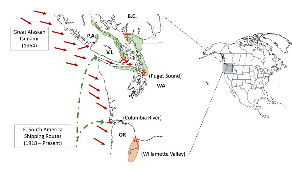
The scientists, microbiologist Arturo Casadevall, MD, PhD, Chair of Molecular Microbiology and Immunology at the Bloomberg School at Johns Hopkins University, and epidemiologist David Engelthaler, PhD, of the Translational Genomics Research Institute, Flagstaff, Arizona, suggest that a series of events brought the fungus to BC culminating in its possible spread by the tsunami unleashed by the 1964 magnitude 9.2 earthquake in Anchorage, Alaska. The scientists wrote that the tsunami idea seemed to fit the “when, where, and why” of this disease emergence.
The US CDC has tracked more than 300 C. gattii fungal infections in the Canadian and U.S. Pacific Northwest region since the first case on Vancouver Island in 1999. Prior to that time, infections with this fungus had been confined almost entirely to Papua New Guinea, Australia, and South America. The fungus typically infects people through inhalation. It can cause a pneumonia-like illness, and may also spread to the brain, causing a potentially fatal meningoencephalitis. Although the disease is fairly rare and few infected people become ill, for those who become infected, published case reports suggest an overall mortality rate of more than 10 percent.
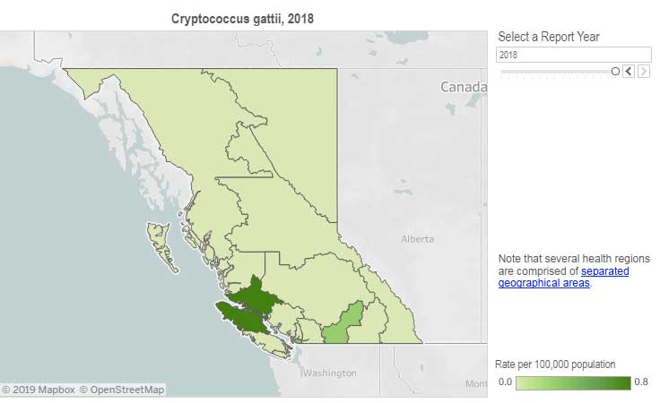
Incidence of Cryptococcus gattii infection in BC (BCCDC)
The British Columbia Centre for Disease Control (BCCDC) says Vancouver Island has one of the highest rates of infection in the world. Each year in B.C. from 10 to 25 people become sick from cryptococcosis and about 16 per cent die from the disease.
In the Northern Health region, however, only one case, in 2017, has been reported since 2009 and that was in the Northern Interior region.
The BCDC says the fungal infection can take several months to incubate after exposure. Only a few people exposed to the spores will become ill. Cryptococcus gattii is a reportable disease in British Columbia.
The new study is suggesting that the fungus first traveled in ships’ ballast tanks. After the Panama Canal opened in 1914, shipping increased significantly between Atlantic and Pacific ports.
The scientists believe that in South America, the fungus began washing from local rivers into shore waters. Then ships loaded ballast water, which research has shown is a common mode of transport for invasive species. The ballast water then spread the fungus to North American waters. Ships in those days routinely took on such ballast water in one port and simply discharged it, without treatment, in another.
How the tropical pathogen established itself in such a cool northern area was originally unclear. Theories have included global warming and the import of tropical eucalyptus trees.
The new study proposes that once in the North Pacific the fungus went unnoticed until the 1964 earthquake brought the fungus widely ashore and into coastal forest area.
It then took several decades for the fungus to evolve in its new habitat so that it could survive and then thrive first in coastal Vancouver Island, then across the island to the Lower Mainland and down to Washington and Oregon.
Casadevall says, “The big new idea here is that tsunamis may be a significant mechanism by which pathogens spread from oceans and estuarial rivers onto land and then eventually to wildlife and humans, If this hypothesis is correct, then we may eventually see similar outbreaks of C. gattii, or similar fungi, in areas inundated by the 2004 Indonesian tsunami and 2011 Japanese tsunami.”
The Alaskan Earthquake was felt as far as 4,500 kilometres away. Effects were recorded on the Hawaiian Islands. The waves reported in nearby Shoup Bay, Alaska were 67 metres causing significant shoreline devastation. At Seward, Alaska, the tsunami wave was 9.2 metres. At Port Alberni it was 6.4 metres. North of Kitimat, at Ketchikan, the wave was just 0.6 metres and at Prince Rupert, 1.4 metres. There are no figures for Kitimat, but with no damage reported, it is likely that the wave was somewhere around a metre.
The tsunami continued south, affecting much of the coastline of western North America, even causing several deaths on the beaches of northern California.
Several hours after the earthquake, multiple waves flowed up Alberni Inlet, cresting at eight metres and striking the Port Alberni region, washing away 55 homes and damaging nearly 400 others
The study retrieved multiple fungus samples from the forests in the Port Alberni region. Studies show there are multiple infected sea mammals in the port’s waterways. Human and terrestrial and marine animal cases have also been reported along the western coast of Vancouver Island. The results suggest that the contamination of the Port Alberni region may be from the 1964 tsunami rather than from terrestrial dispersal from the eastern side of Vancouver Island.
Map showing where the 1964 tsunami could have deposited the fungus (Ecological and Evolutionary Science)
The early environmental analyses in British Columbia identified that the fungus was found in soils and trees in the coastal Douglas fir forests and in coastal Western Hemlock forests bordering the coastal Douglas fir forest. While these studies were “limited in geographical space” the contaminated landscapes were also the known locations of human and animal infections. Further ecological analyses have identified higher levels of soil and tree contamination at low-lying elevations close to sea level.
The researchers now hope to continue testing their hypothesis with detailed analyses of C. gattii in soils within and outside tsunami-inundated areas of the Pacific Northwest. They then want to compare the British Columbia fungus with DNA collected from other parts of the world.–to see if the same C. gattii subtypes found in Brazil and the Pacific Northwest are more widely present in seawaters around ports.
The paper: “On the emergence of Cryptococcus gattii in the Pacific Northwest: ballast tanks, tsunamis and black swans” by David Engelthaler and Arturo Casadevall is in the journal Ecological and Evolutionary Science
BCDC defintion Cryptococcus is a tiny (microscopic) yeast-like fungus. A species of this fungus, called Cryptococcus gattii, has been living on trees and in the soil on the east coast of Vancouver Island since at least 1999. More recently it has also been found in the Vancouver Coastal and Fraser Health regions. Infrequently, people and animals (e.g. cats, dogs, llamas, porpoises) exposed to this fungus become sick with cryptococcal disease (or cryptococcosis). Cryptococcosis can affect the lungs (pneumonia) and nervous system (meningitis) in humans. It affects people with healthy and weakened immune system. In rare cases, this disease can be fatal.
Many people will be exposed to the fungus sometime during their lives and most of these will not get sick. In people who become ill, symptoms appear many months after exposure.
Symptoms of cryptococcal disease include:
Prolonged cough (lasting weeks or months)
Shortness of breath
Headache
Vomiting
Fever
Weight loss
If symptoms occur, the disease can cause pneumonia, meningitis, nodules in the lungs or brain, or skin infection.
People are advised to see their doctor if they live in or visit an area where the fungus can be found and experience these symptoms.
Most historians and archaeologists believe that the First Peoples to arrive in North America came down the West Coast on what they now call the “kelp highway.”
Evidence from archaeological sites from the British Columbia coast to the southern tip of South America show that First Peoples had settled on both continents by at least 18,000 years ago, according to authors T.J. Braje at San Diego State University in San Diego, CA; T.D. Dillehay at Vanderbilt University in Nashville, TN; J.M. Erlandson at University of Oregon in Eugene, OR; R.G. Klein at Stanford University in Stanford, CA; T.C. Rick at National Museum of Natural History, Smithsonian Institution in Washington, DC.
The paper also says the DNA genomic data suggests a northeast Asian origin for Native American ancestors some time in the past 20,000 years.
(Science)
One of the key sites cited in the paper is Triquet Island in the traditional territory of the Heiltsuk Nation which has been dated to at least 14,000 years ago. Heiltsuk oral history has marked the island for generations, William Housty a member of the Heiltsuk told CBC News at the time the discovery was officially announced in April 2017, “Heiltsuk oral history talks of a strip of land in that area where the excavation took place. It was a place that never froze during the ice age and it was place where our ancestors flocked to for survival.”
The authors of the review say the new consensus on the “kelp highway” is a “dramatic intellectual turnabout” from the original idea that the first indigenous settlers followed an ice free corridor from a land bridge from Siberia down the centre of North America to form the “Clovis Culture”
The land bridge between northeast Asia and North America, commonly called Beringia, came about when sea levels fell during the last ice age. Although the original Beringia hypothesis has been disputed by some First Peoples, the paper says the Beringia hypothesis is still a factor—but much farther back in time, now about 24,000 years ago.
The paper says:
most archaeologists and other scholars now believe that the earliest Americans followed Pacific Rim shorelines from northeast Asia to Beringia and the Americas.
According to the kelp highway hypothesis, deglaciation of the outer coast of North America’s Pacific Northwest about 17,000 years ago created a possible coastal corridor rich in aquatic and terrestrial resources along the Pacific Coast, with productive kelp forest and estuary ecosystems at sea level and no major geographic barriers
The paper says that kelp resources extended as far south as Baja California, and then—after a gap in Central America, where productive mangrove and other aquatic habitats were available—picked up again in northern Peru, where the cold, nutrient-rich waters from the Humboldt Current supported kelp forests as far south as Tierra del Fuego.
The other sites cited in the paper are
Huca Prieta, Peru 15,000 to 14,500 years ago
Paisley Caves, Oregon 14,000 years ago
Monte Verde, Chile 14,500 years ago
Page-Ladson, Florida 14,500 years ago
Channel Islands California 13,000 years ago
Quebrada Santa Julia and Quebrada Huentelauquén , Chile 13,000 years ago
Quebrada Tacahuay Peru 13,000 years ago
Quebrada Jaquay, Peru 13,000 years ago
In an earlier article in Science in August, Knut Fladmark, a professor emeritus of archaeology at Simon Fraser University who was one of the first to propose a coastal migration into the Americas back in 1979, said: “The land-sea interface is one of the richest habitats anywhere in the world,” noting that early Americans knew how to take full advantage of its abundant resources.
Testing the kelp highway hypothesis is challenging, the scientists say, because much of the archaeological evidence would have been submerged by rising seas since the end of the last “glacial maximum,” about 26,500 years ago.
The earlier that the First Peoples arrived, that means the land they originally settled is now the further offshore from the current coast (land which is now likely also at greater depth under the current ocean). So the review says that finding the evidence means that, “enlarging already vast potential search areas on the submerged continental shelf.”
The authors say:
Although direct evidence of a maritime pre-Clovis dispersal has yet to emerge, recent discoveries confirm that late Pleistocene archaeological sites can be found underwater. Recent discoveries at the Page-Ladson site, in Florida produced 14,500-year-old butchered mastodon bones and chipped stone tools in the bottom of Florida’s Aucilla River.
The report says that “Several multidisciplinary studies are currently mapping and exploring the submerged landscapes of North America’s Pacific and Gulf of Mexico coasts, searching for submerged sites. .
In British Columbia, those studies (pdf) include the discovery by Daryl Fedje, an archaeologist at the University of Victoria and the Hakai Institute of 29 footprints on Quadra Island. A piece of wood embedded in a footprint’s fill provided the radiocarbon date of 13,200 years ago and the spear points lying and a cluster of bear bones at Gaadu Din cave on the Haida Gwaii dated to 12,700 years ago.
The review says that for much of the 20th century, most archaeologists believed humans first colonized the Americas about 13,500 years ago via the overland route that crossed Beringia and followed a long and narrow, mostly ice-free corridor to the vast plains of central North America. There, according to the earlier theories, Clovis people and their descendants hunted large game and spread rapidly through the New World.
This was initially confirmed by twentieth-century discoveries of distinctive Clovis artifacts throughout North America. Some finds associated with mammoth or mastodon kill sites, supported this “Clovis-first” model.
The early studies decided then that “North America’s coastlines and their rich marine, estuarine, riverine, and terrestrial ecosystems were peripheral to the story of how and when the Americas were first settled by humans.”
Now the recent work along the Pacific coastlines of North and South America has revealed that these environments were settled early and continuously, providing a rich diversity of subsistence options and technological resources for New World hunter-gatherers.
A detail of the map from Science shows how off from the current coast the ancient shorelines reached (Science)
At the moment, there is little evidence on the coast so far of the kind of stone tools and fishtail points that had previously provided a road map that archaeologists used to trace the spread of “Clovis” Paleoindians throughout the Americas. Such a roadmap is lacking for “pre-Clovis” sites on the coast.
One proposal is that distinctive stemmed (“tanged”) chipped-stone projectile points, crescents (lunate-shaped), and leaf-shaped bifaces found in Japan, northeast Asia, western North America, and South America could be potential markers of an earlier coastal migration and ties to Ice Age peoples in East Asia.
The problem of finding final proof of the kelp highway is that the First Peoples followed a coastal route from Asia to the Americas, so that finding evidence for their earliest settlements will require careful consideration of the effects of sea level rise and coastal landscape evolution on local and regional archaeological records.
The scientists note that around the globe, evidence for coastal occupations between about 50,000 and 15,000 years ago are rare because of postglacial sea level rise, marine erosion, and shorelines that have migrated tens or even hundreds of kilometers from their locations at the ice age glacial maximum.
They say overcoming these obstacles requires interdisciplinary research focused on coastal areas with relatively steep offshore bathymetry, formerly glaciated areas where ancient shorelines have not shifted so dramatically, or the submerged landscapes that are one of the last frontiers for archaeology in the Americas
UPDATED with comments from District of Kitimat, Terrace and the Gitga’at Nation
A preliminary seismic hazard assessment by Natural Resources Canada has identified possible earthquake scenarios for the Douglas Channel near Hartley Bay, Terrace and Bella Bella.
The same studies indicate that while Kitimat may not be directly in a seismic zone prolonged earthquakes cause some damage in Kitimat depending on the earthquake and the condition of the soil in certain parts of the District. One model scenario says that in the event of a magnitude 8.0 earthquake off the west coast of Haida Gwaii, given certain soil conditions, there might actually be more damage in Kitimat than on the islands.
Susceptibility to landslides
That assessment, part of the overall the study by the Geological Survey of Canada indicates that the north coast of British Columbia from Prince Rupert to Bella Bella is likely face to “seismically induced ground failure”– mostly landslides.
Overall, the report says that on a scale of 1 to 6 (6 representing the highest
susceptibility), the majority of the west coast of BC “exhibits landslide susceptibility values of 5 to 6, which is significantly higher than the rest of Canada.”
Geological Survey of Canada map showing parts of Canada that are prone to landslides. The BC North Coast study area is outlined by the rectangle. (Geological Survey of Canada)
In British Columbia the landslides are most likely to be triggered by delayed melting of the annual snow pack, heavy rains, bank erosion and site loading and caused long-lasting damning of the river causing “damage to pipelines, rail, and forestry, as well as fish habitats.”
So far no recent landslides along the northern British Columbia coast are known to be caused by earthquakes, the reports say “the existence of numerous landslides strengthens the likelihood of seismically induced ground failures… due to the high levels of seismicity….it is expected that the increased likelihood of strong ground shaking (with long durations) will increase the landslide susceptibility.”
New studies
It was only after the 2012 Haida Gwaii earthquake and with what the Geological Survey of Canada calls “a growing number of on-going and planned infrastructure projects, BC’s north coast is emerging as a region of high strategic importance to Canada’s economy,” that studies began in area where “there has been minimal research to understand earthquake hazards.”
Now that studies have begun the Geological Survey has given the region its own new acronym BCNC (BC North Coast). Haida Gwaii is not part of BCNC, although earthquakes on those islands would likely impact the coast.
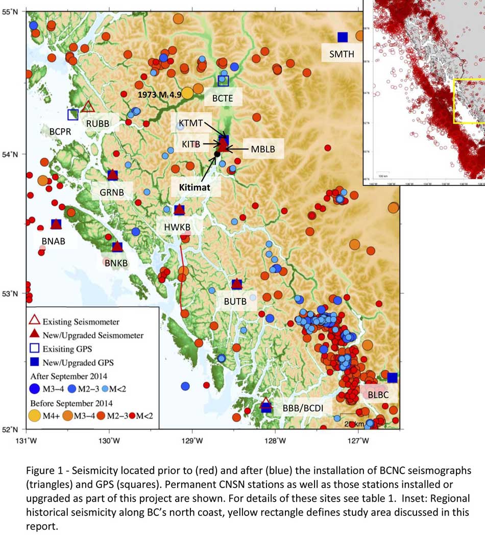
A Geological Survey of Canada map showing the BC North Coast region with earthquakes identified prior to and during recent studies. (Geological Survey of Canada)
The Geological Survey says that historically “the BCNC has been seismically quiescent.” As a result “seismic monitoring and research related to the BCNC has been minimal.” That meant while larger earthquakes were “felt and recorded,” the configuration of the Canadian National Seismograph Network did not allow earthquakes less than approximately magnitude 2.1 to be monitored in northern BC.
Now the Geological Survey is looking at “long-term, continuous monitoring of micro seismicity, combined with geodetic and paleo seismic techniques” that could be used to study at the possibility of large earthquakes, including a possible fault on the lower Douglas Channel.
Since the studies began in August 2014, the Geological Survey identified 145 earthquakes within the study area, many too small to be felt since they are less than magnitude 2.0. Those earthquakes, however, were picked up by the new and improved instrumentation used by the earthquake monitors.
The two reports one on “seismic hazards” and the second on “geohazards” says five “temporary seismonitors” (download reports from links below) were installed within the BCNC while some older stations were upgraded, saying, “It is expected that these new stations will be aid in locating small earthquakes” that were not previously detected by the existing network. The Geological Survey also installed ground movement monitoring GPS units along the coast.
The use of the term “temporary” raises the question about how much ongoing monitoring is planned.
The study also notes that the current data is not included in the seismic standards in the current National Building Code of Canada, which in turn is based on the Natural Resources Canada Seismic Hazard Map. That may mean that municipalities in the BC North Coast region, in the future, as the seismic studies continue, may have to consider updating building codes, especially in areas of “softer soils” as opposed to harder rock.
“Fault-like structure” on Douglas Channel
Detail of a map from the Geological Survey of Canada where the red line shows the 60 kilometre possible (still unconfirmed) fault line running from Gribbell Island to Princess Royal Island (Geological Survey of Canada)
Over the years some small earthquakes have also been recorded on what the Geological Survey calls the “recently mapped fault-like structure” on Douglas Channel which was discovered in 2012. The survey is still calling it “fault-like” because it has not yet been confirmed as an active fault. A new map in the study shows that the “fault” runs from the southern tip of Gribbell Island, down the centre of Whale Channel east of Gil Island and then along the western coast of Princess Royal Island.
The study identified “a small, unfelt swarm of earthquakes between magnitude 1.7 and 2.0 between September 13 and 14, 2010 near Gil Island.”
There is also the previously identified ancient Grenville Channel Fault (ancient and believed inactive because it dates from the Cretaceous, the age of the dinosaurs) that runs from along Grenville Channel from Porcher Island in the north to Klemtu in the south which has experienced small earthquakes.
The report says geological studies of the Douglas Channel “fault-like structure” are a priority because, “Should this structure be determined to be an active fault, it would pose significant risk of earthquake-triggered landslides (and subsequent tsunami) from the susceptible Douglas Channel hill slopes.”
Clay and sand in Kitimat
The report also calls for more studies the local geology and soil conditions in the Kitimat Valley. A study back in 1984 by John Clague of Simon Fraser University showed that as the glaciers retreated during the last Ice Age there were “periods of stagnation” resulting in sediments that are thicker than other regions of British Columbia, Clague reported that in parts of Kitimat, the glacial moraine is hundreds of metres thick.
After the glaciers were gone, the sea levels rose and glaciomarine sediments (clay, silt up to 60 metres thick) were deposited until the sea level fell to present-day levels. The report says that as these marine deposits were exposed to fresh water, salts were leached out resulting in saturated, porous sediments, including clay, which are prone to failure. Boreholes in the Kitimat area show that the clay and sediments above the bedrock can range from 17 metres to 106 metres.
The report notes the presence of clay soils “can amplify ground shaking and secondary effects” as happened in November 1988 when there was an earthquake in the Saguenay region of Quebec.
Originally reported as a 6.2 magnitude but later downgraded to 5.9, on Nov. 25, 1988, the major earthquake was centered near the Quebec cities of Chicoutimi and Jonquière, with aftershocks felt as far away as Toronto, Halifax and Boston. The quake lasted for two minutes, catching thousands of people off guard and leaving buildings damaged and power out for hundreds of thousands of Quebecers.
The report says the most significant event within the BC North Coast study region (which as mentioned doesn’t include Haida Gwaii) was a magnitude 4.9 earthquake approximately 20 kilometers southwest of Terrace on November 5, 1973, which was felt as far as 120 kilometers away, with some minor damage (broken windows and cracked plaster) reported near the epicentre. The main shock at Terrace was preceded by a magnitude 2.5 foreshock four hours before, and followed by a felt magnitude 3.7 aftershock the next day.
Bella Bella at risk
Another area most at risk, according to the report, is southern part of the BC North Coast zone, near Bella Bella, which is close to the northern section Cascadia Subduction Zone a “1,000 kilometre long dipping fault that stretches from Northern Vancouver Island to Cape Mendocino California” which one day will cause a major earthquake along the fault.
Cascadia subduction zone (USGS)
The report says that a magnitude 9.0 or higher earthquake in the northern Cascadia Subduction zone close to Bella Bella would be similar to the March 2011 earthquake in Japan and the 1964 Good Friday earthquake in Alaska.
For the northern part of the BC North Coast region, hazards could come from either a major earthquake off Haida Gwaii or a similar earthquake in south-eastern Alaska.
The greatest hazard would come from “long period” earthquakes greater than magnitude 6.75 with an epicentre between 300 and 350 kilometers away where the shaking lasts longer than one second.
The Geological Survey modeled three possible scenarios for major earthquakes in the BC North Coast Region.
Model #1. A magnitude 8.0 Earthquake at Haida Gwaii
The Geological Survey Canada model for an 8.0 magnitude earthquake west of Haida Gwaii. The possible damage is colour coded in the table below the map according to the Modified Mercalli Intensity Scale. The red polygon represents the area of possible rupture in the model with the star representing the epicentre. (Geological Survey of Canada)
The model looked at a “plausible maximum predicted” magnitude 8.0 thrust fault earthquake off the west coast of Haida Gwaii which would be twice as strong in the fault area as the 7.8 quake on October 28, 2012 (Remember Magnitudes are based on a logarithmic scale. That means for each whole number higher, the amplitude of the ground motion recorded by a seismograph goes up ten times so magnitude 8 earthquake would result in ten times the ground shaking as a magnitude 7 earthquake)
For a short period earthquake, the report estimates that there would be minimal damage on Haida Gwaii similar to the damage from the 2012 earthquake with little or no damage on the BC North Coast.
A long duration, long period earthquake that lasted longer than one second and up to three seconds or longer “may effect taller structures and trigger ground failure (that is liquefaction and lateral shaking).” Kitimat would feel that earthquake with the worst shaking in parts of the District with what the report calls “sensitive soils.” Coastal islands would feel double the amount of shaking as would occur in Kitimat.
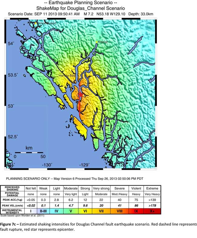
Model #2. A magnitude 7.2 Earthquake in Douglas Channel
The Geological Survey Canada model for a 7/2 magnitude earthquake in the lower Douglas Channel. The possible damage is colour coded in the table below the map according to the Modified Mercalli Intensity Scale. The red star represents the possible epicentre. (Geological Survey of Canada)
The second model looked at an earthquake in Douglas Channel based on the “fault like structure” if a slip strike rupture occurred along the entire 60 kilometers of the so far unconfirmed fault, resulting in a 7.2 magnitude earthquake. There would be very strong shaking within 20 kilometers radius of the epicentre, with moderate to heavy damage” in the relatively uninhabited islands, major shaking in Hartley Bay, resulting in very strong to strong damage at Hartley Bay and strong to moderate damage in Kitimat.
That earthquake, however, would be felt across the entire province of British Columbia. The report notes:
The expected effects and impacts of such an earthquake would mimic those of the 1946 magnitude 7.3 Vancouver Island earthquake, which occurred slightly west of Courtney and Campbell River. Shaking due to the 1946 earthquake was felt as far as Prince Rupert, BC to the north and Portland, Oregon to the south. In addition to knocking down 75 per cent of the chimneys in the local area, much of the earthquake-related damage was due to landslides, slumping and liquefaction
Model #3 A magnitude 6.3 Earthquake near Terrace
The Geological Survey Canada model for an 6.3 magnitude earthquake southwest of Terrace. The possible damage is colour coded in the table below the map according to the Modified Mercalli Intensity Scale. The red polygon represents the area of possible rupture in the model with the star representing the epicentre. (Geological Survey of Canada)
On May 11, 1973, a magnitude 4.7 shallow earthquake took place about 20 kilometers south west of Terrace, on the south side of the Skeena roughly across from the Shames mountain area. The earthquake was felt up to 120 kilometers away. The report says “The event has not been associated with any geologic features in the area and little is known about its rupture process.” The model estimated the results of a larger earthquake 6.3 magnitude in the same area. The model showed there would be strong to very strong shaking in Terrace, light to moderate shaking in Kitimat and light damage elsewhere in the BC North Coast. Most of the damage would be concentrated in a 20 kilometer zone around the epicentre.
The cause of the two failures is still unknown but the report says “their proximity to a nearby unmapped fault-like structure suggests that the slides could have been triggered by strong ground shaking from rupture along this structure.”
Another factor was the two well-known landslides occurred in the 1970’s in the Kitimat Arm which generated tsunamis but fortunately they occurred at low tide which decreased the impact. On October 17, 1974 a submarine slide generated a 2.8 metre tsunami. The following year on April 27, 1975, a slope failure on the northeast side of Kitimat Arm (which overlapped the 1974 failure area) displaced an estimated upper limit of 26,000,000 cubic metres of material.
“Watermark observations in Kitamaat Village estimated that the tsunami generated by this slide was up to 8.2 metres high.” The report says that while the trigger of the first event is unknown; the latter event coincided with nearby construction at that time. Modelling of the 1975 slide estimates that given the right conditions the generated tsunami waves could have been as high as 11 metres.
The report also notes that numerous landslides have also been mapped by the BC Department of Forestry in an attempt to improve safety measures for forestry workers.
The report says “The culmination of these studies brings awareness to the significant natural hazards present in the fragile coastal environment of the Coast Ranges.”
Another factor is the geology of the BC coast. The granitic mountains have rugged, steep slopes dissected by an intricate fjord system and dotted with islands of lower elevation. At lower elevations the land is covered by wet, coastal hemlock forests, which could be vulnerable to ground failures whereas higher elevations are characterized by barren rock or mountain hemlock subalpine.
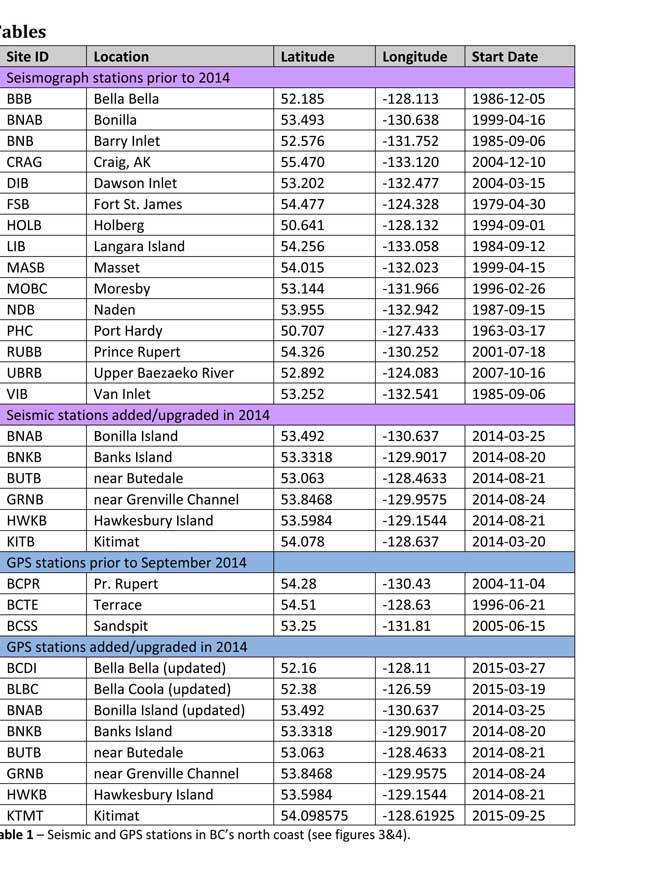
Table of Seismic monitoring and GPS stations in northern BC from the Geological Survey of Canada (Geological Survey of Canada)
The District of Kitimat said it has “not directly studied these issues but we are aware of potential hazards.” The development department has been advised of potential issues and site concerns.
A spokesperson for Terrace mayor Carol Leclerc told Northwest Coast Energy News in an e-mail. “I have reviewed it and distributed it to the relevant department heads. We are aware that historically Terrace has been at risk for experiencing seismic activity due to its location.”
The District of Kitimat did cooperate with National Resources in finding a location for their recently installed seismic equipment.
At Harley Bay, Gitga’at First Nation CEO Ellen Torng said the Gitga’at have been “ working with NRCan on their research in the Douglas Channel and in Hawksbury. NRC has been meeting with First Nations along the coast and have conducted community sessions on their research.
“We hosted one community session here in Hartley Bay and have regular updates from their technical team when they are in the area,” Torng said.
In addition, the District of Kitimat told Northwest Coast Energy News that Community Planning & Development department also provided local land information to geoscientists in the years leading up an international study called Batholiths on land in 2009.
Batholiths are large zones of molten rock that have solidified in the earth’s crust and are believed to play a key role in the formation and growth of continents. The Coast Mountain Range has a large concentration of batholiths, which means Kitimat was an excellent place to study the earth’s crust.
The project, which involved more than 50 scientists from nine Canadian and American universities, was set up to examine how mountain belts form and change over time and why continental mountain ranges are made of granite not basalt. Seismic imaging of the crust and mantle below the mountains required deploying thousands of seismic sensors and recorders, and recorded responses to several man-made detonations. Field work was completed in July 2009, and several scientific papers and dissertations have followed.
The Heiltsuk Nation was unable to respond to a request for comment due to the ongoing crisis from the sinking of the tug Nathan E. Stewart and the resulting spill of diesel fuel and other contaminants near Bella Bella.
Not felt except by a very few under especially favorable conditions.
II
Weak
Felt only by a few persons at rest,especially on upper floors of buildings.
III
Weak
Felt quite noticeably by persons indoors, especially on upper floors of buildings. Many people do not recognize it as an earthquake. Standing motor cars may rock slightly. Vibrations similar to the passing of a truck. Duration estimated.
IV
Light
Felt indoors by many, outdoors by few during the day. At night, some awakened. Dishes, windows, doors disturbed; walls make cracking sound. Sensation like heavy truck striking building. Standing motor cars rocked noticeably.
V
Moderate
Felt by nearly everyone; many awakened. Some dishes, windows broken. Unstable objects overturned. Pendulum clocks may stop.
VI
Strong
Felt by all, many frightened. Some heavy furniture moved; a few instances of fallen plaster. Damage slight.
VII
Very strong
Damage negligible in buildings of good design and construction; slight to moderate in well-built ordinary structures; considerable damage in poorly built or badly designed structures; some chimneys broken.
VIII
Severe
Damage slight in specially designed structures; considerable damage in ordinary substantial buildings with partial collapse. Damage great in poorly built structures. Fall of chimneys, factory stacks, columns, monuments, walls. Heavy furniture overturned.
IX
Violent
Damage considerable in specially designed structures; well-designed frame structures thrown out of plumb. Damage great in substantial buildings, with partial collapse. Buildings shifted off foundations.
X
Extreme
Some well-built wooden structures destroyed; most masonry and frame structures destroyed with foundations. Rails bent.
The Ice Age First Nations in the interior of Alaska relied more heavily on salmon and freshwater fish in their diets than previously thought, according to a new study from the University of Alaska Fairbanks.
First Nations of the Pacific Coast have always recognized the value of the salmon. Archaeologists have used new techniques to date the remains of salmon found in hearths back more than 11,000 years. The results now offer a more complex picture of Alaska’s ice age residents, who were previously thought to have a diet dominated by terrestrial mammals such as mammoths, bison and elk.
A team of researchers made the discovery after taking samples from 17 prehistoric hearths along the Tanana River, then analyzed stable isotopes and lipid residues to identify fish remains at multiple locations.
The project also found the earliest evidence of human use of anadromous salmon in the Americas, dating back at least 11,800 years.
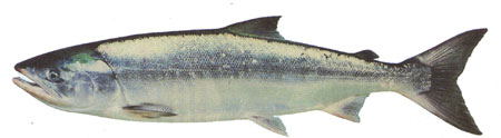
Chum salmon (DFO)
The results of the study were published today in the Proceedings of the National Academy of Sciences.
DNA analysis of chum salmon bones from the same site on the Tanana River had previously confirmed that fish were part of the local indigenous diet as far back as 11,500 years ago. But fragile fish bones rarely survive for scientists to analyze, so the team used sophisticated geochemistry analyses to estimate the amount of salmon, freshwater and terrestrial resources ancient people ate.
A team led by UAF postdoctoral researcher Kyungcheol Choy analyzed stable isotopes and lipid residues, searching for signatures specific to anadromous fish. The effort demonstrated that dietary practices of hunter-gatherers could be recorded at sites where animal remains hadn’t been preserved.
“It’s quite new in the archaeology field,” Choy said. “There’s a lot in these mixtures that’s hard to detect in other ways.”
Ben Potter, a professor of anthropology at UAF and co-author of the study, said the findings suggest a more systematic use of salmon than DNA testing alone could confirm.
“This is a different kind of strategy,” Potter said. “It fleshes out our understanding of these people in a way that we didn’t have before.”
The study required cooperation between UAF’s Department of Anthropology and the Institute of Northern Engineering’s Alaska Stable Isotope Facility to locate and interpret the presence of salmon remains at the sites. Potter said the process could be a template for how a diverse team of researchers can work together to overcome a scientific obstacle.
“It’s an awesome look at how we can merge disciplines to answer a question,” he said.
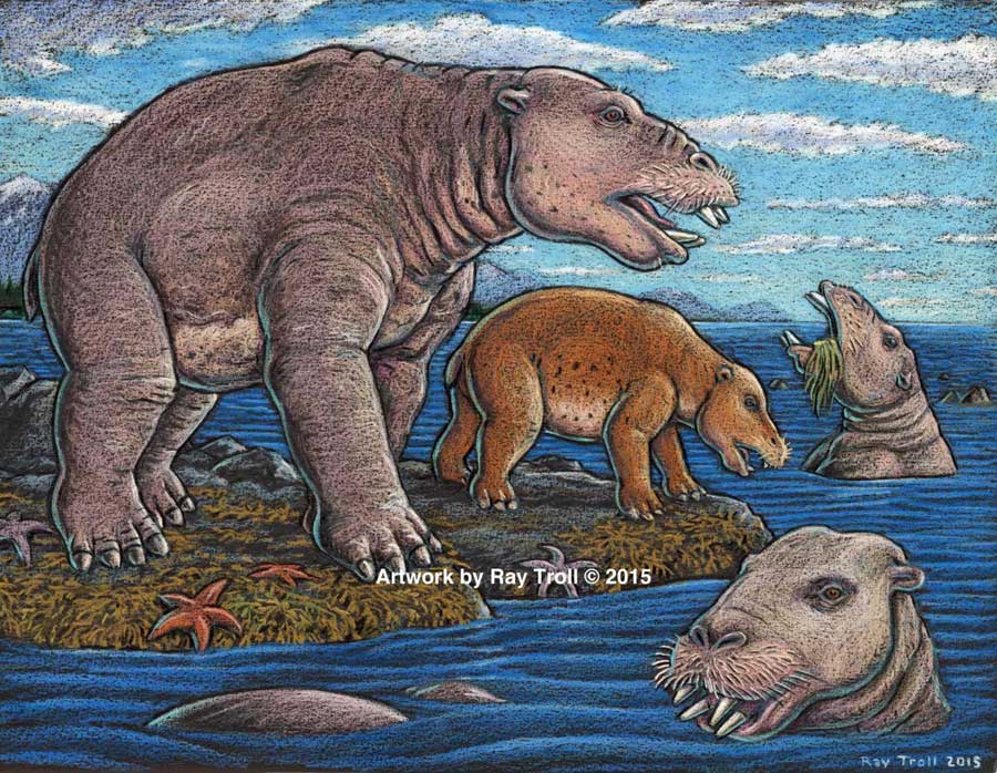
Scientists have identified a new species of a strange marine mammal group that lived on the Pacific Coast between 33 million years ago and 10 million years ago. The new specimens — from at least four individuals — were recovered from Unalaska, in theAleutians.
The Desmostylians, unlike other marine mammals species alive today — such as whales, seals and sea cows –are extinct. The researchers call them “desmos” for short. Unlike whales and seals, but like manatees, desmos were vegetarians
The desmos are found from Baja, California, up along the west coast of North America, around the Alaska Peninsula, the storm-battered Aleutian Islands, to Russia’s Kamchatka Peninsula and Sakhalin Island, to the Japanese islands
Their strange columnar teeth and odd style of eating don’t occur in any other mammal. They rooted around coastlines, ripping up vegetation, such as marine algae, sea grass and other near-shore plants.
The new species, 23 million years old was a big, hippo-sized animal with a long snout and tusks, It has a unique tooth and jaw structure that indicates it was not only a vegetarian, but literally sucked vegetation from shorelines like a vacuum cleaner, said vertebrate paleontologist and study co-author Louis L. Jacobs, Southern Methodist University, Dallas.
They probably swam like polar bears, using their strong front limbs to power along. On land, they would have had the lumbering gait of a sloth.
A large, stocky-limbed mammal, desmos’ modern relatives remain a mystery. Scientists have previously linked the animals perhaps to manatees, horses or elephants. Adult desmostylians were large enough to be relatively safe from predators.
The identification of a new species belonging to Desmostylia has intensified the rare animal’s brief mysterious journey through prehistoric time, according to the new study.
While alive, the newly discovered creatures lived in what is now Unalaska’s Dutch Harbor.
“The new animal — when compared to one of a different species from Japan — made us realize that desmos do not chew like any other animal,” said Jacobs, a professor of earth sciences. “They clench their teeth, root up plants and suck them in.”
To eat, the animals buttressed their lower jaw with their teeth against the upper jaw, and used the powerful muscles that attached there, along with the shape of the roof of their mouth, to suction-feed vegetation from coastal bottoms. Big muscles in the neck would help to power their tusks, and big muscles in the throat would help with suction.
Discovery of the new genus and species that resembled a hippo and swam like a bear, from Unalaska indicates the desmostylian group was a successful group that was larger and more diverse than previously known. (Artist: Ray Troll)
“No other mammal eats like that,” Jacobs said. “The enamel rings on the teeth show wear and polish, but they don’t reveal consistent patterns related to habitual chewing motions.”
The new specimens also represent a new genus — meaning desmostylians in the same family diverged from one anoher in key physical characteristics, particularly the tooth and jaw structure, said Jacobs, who is one of 10 scientists collaborating on the research.
Discovery of a new genus and species indicates the desmostylian group was larger and more diverse than previously known, said paleontologist and co-author Anthony Fiorillo, vice president of research and collections and chief curator at the Perot Museum of Nature and Science, Dallas, and an adjunct research professor at SMU.
“Our new study shows that though this group of strange and extinct mammals was short-lived, it was a successful group with greater biodiversity than had been previously realized,” Fiorillo said.
Compared to other mammals, desmos were latecomers and didn’t appear on earth until fairly recently — 33 million years ago. Also unusual for mammals, they survived a mere 23 million years, dying out 10 million years ago.
The research was funded by the Perot Museum of Nature and Science, U.S. National Park Service – Alaska Region Office, and SMU’s Institute for the Study of Earth and Man.
The newest desmo made its home on Unalaska Island, the farthest north of any occurrence of the group, which only lived along the shores of the North Pacific.
“That’s the only place they’re known in the world,” Jacobs said. The Unalaska fossils represent at least four individuals, and one is a baby.
“The baby tells us they had a breeding population up there,” Jacobs said. “They must have stayed in sheltered areas to protect the young from surf and currents.”
In addition, “the baby also tells us that this area along the Alaska coast was biologically productive enough to make it a good place for raising a family,” said Fiorillo.
Just as cattle assemble in a herd, and a group of fish is a school, multiple desmostylians constitute a “troll” — a designation selected by Jacobs to honor Alaskan Ray Troll, the artist who has depicted desmos most.
The first Unalaska fossils were discovered in the 1950s in a rock quarry during U.S. Geological Survey mapping.
Others found more recently were on display at the Ounalashka Corporation headquarters. Those specimens were offered to Fiorillo and Jacobs for study after Fiorillo gave a public presentation to the community on his work in Alaska.
“The fruits of that lecture were that it started the networking with the community, which in turn led us to a small, but very important collection of fossils that had been unearthed in the town when they built a school a few years earlier,” Fiorillo said. “The fossils were shipped to the Perot Museum of Nature and Science for preparation in our lab and those fossils are the basis for our work now.”
From there, the researchers discovered that the fossils were a new genus and species.
The authors report their discoveries in a special volume of the international paleobiology journal, Historical Biology. The article published online Oct. 1 at http://bit.ly/1PQAHZJ
The researchers named the new mammal Ounalashkastylus tomidai. “Ounalashka,” means “near the peninsula” in the Aleut language of the indigenous people of the Aleutian Islands.
“Stylus” is from the Latin for “column” and refers to the shape of cusps in the teeth.
“Tomida” honors distinguished Japanese vertebrate paleontologist Yukimitsu Tomida.
The article appears in a special volume of Historical Biology to honor the career accomplishments of Tomida upon his retirement from the Department of Geology and Paleontology in Tokyo’s National Museum of Nature and Science.
In addition to Jacobs, Fiorillo and Polcyn, other authors were Yosuke Nishida, SMU; Yuri Kimura, Smithsonian Institution and the Tokyo Museum; Kentaro Chiba, University of Toronto; Yoshitsugu Kobayashi, Hokkaido University Museum, Naoki Kohno, National Museum of Nature and Science; and Kohei Tanaka, University of Calgary.
The Historical Biology article is titled “A new desmostylian mammal from Unalaska (USA) and the robust Sanjussen jaw from Hokkaido (Japan), with comments on feeding in derived desmostylids” and appears in the special issue “Contributions to vertebrate palaeontology in honour of Yukimitsu Tomida.”
“Very low levels” of crude oil from the 1989 Exxon Valdez spill in Prince William Sound, Alaska, are a threat to the survival of herring and pink salmon that spawn in the region, according to a study released today by the US National Oceanic and Atmospheric Administration.
The study shows that embryonic salmon and herring exposed to very low levels of crude oil can develop hidden heart defects that compromise their later survival.
That means that the Exxon Valdez spill on March 24, 1989 may have had much greater impacts on spawning fish than previously recognized, according to the study published in Nature’s online journal Scientific ReportsVery low embyronic crude oil exposures cause lasting defects in salmon and herring.
“These juvenile fish on the outside look completely normal, but their hearts are not functioning properly and that translates directly into reduced swimming ability and reduced survival,” said John Incardona, a research toxicologist at NOAA Fisheries’ Northwest Fisheries Science Center (NWFSC) in Seattle. “In terms of impacts to shore-spawning fish, the oil spill likely had a much bigger footprint than anyone realized.”
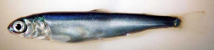
This is a juvenile pink salmon exposed to low levels of crude oil as an embryo. While these fish appear outwardly normal, they nevertheless developed heart defects that compromised their ability to swim. Fish that are less able to forage and avoid predators are much less likely to survive to adulthood. (NOAA)
Previous research has shown that crude oil disrupts the contraction of the fish heart muscle cells. Embryonic fish exposed to trace levels of crude oil grow into juveniles with abnormal hearts and reduced cardiorespiratory function.
“With this very early impact on the heart, you end up with an animal that just can’t pump blood through its body as well, which means it can’t swim as well to capture food, form schools, or migrate,” said Mark Carls, toxicologist at the Alaska Fisheries Science Center. “Crude oil is changing basic physiology, or what makes a fish a fish.”
The research builds on earlier work by the Auke Bay Laboratories, part of NOAA Fisheries’ Alaska Fisheries Science Center, which found much reduced survival of pink salmon exposed as embryos to polycyclic aromatic hydrocarbons (PAH) from crude oil.
“Our findings are changing the picture in terms of assessing the risk and the potential impacts of oil spills,” said Nat Scholz, leader of the NWFSC’s ecotoxicology program and a coauthor of the new study. “We now know the developing fish heart is exquisitely sensitive to crude oil toxicity, and that subtle changes in heart formation can have delayed but important consequences for first-year survival, which in turn determines the long-term abundance of wild fish populations.”
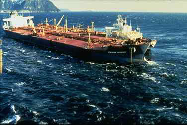
The Exxon Valdez aground on Bligh Reef in Prince William Sound in March 1989. (NOAA)
The Exxon Valdez spill was the largest in U.S. history, with extensive oiling of shoreline spawning habitats for Pacific herring and pink salmon, the two most important commercial fish species in Prince William Sound.
Herring larvae sampled in proximity to oil were visibly abnormal, and mortality rates were higher for pink salmon embryos at oil spill sites than unaffected regions.
The herring fishery collapsed three to four years after the spill, when the herring spawned in oiled areas reached reproductive maturity.
The paper notes that the contribution of the spill to the herring population collapse, if any, was never determined and remains controversial.
Other studies, however, tend to confirm the findings, including heart problems for fish exposed to the Gulf of Mexico Deepwater Horizon spill and even fish exposed to naturally occurring oil seeps.
The new findings suggest that the delayed effects of the spill may have been important contributors to the declines.
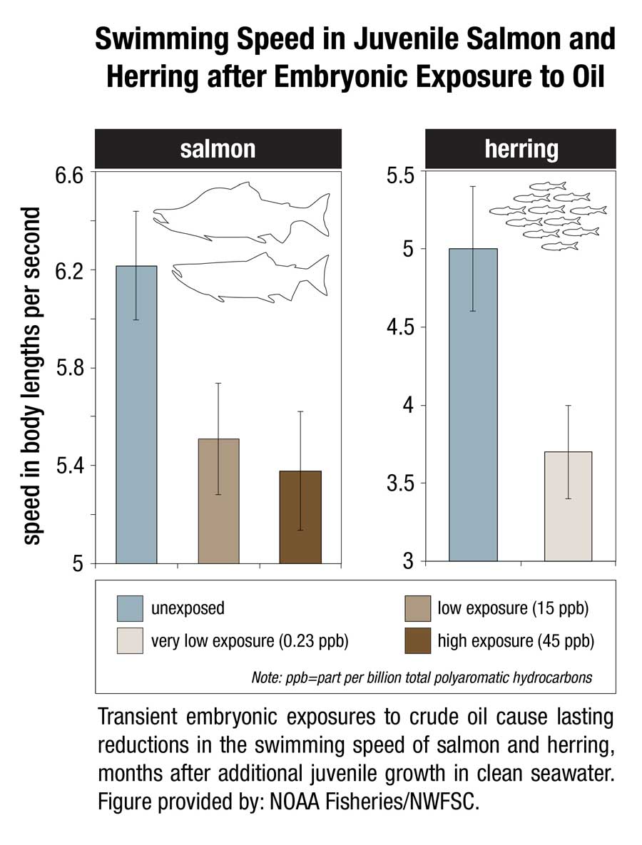
This image shows transient embryonic exposures to crude oil cause lasting reductions in the swimming speed of salmon and herring, months after additional juvenile growth in clean seawater. (NOAA)
Scientists from the Northwest Fisheries Science Center and Alaska Fisheries Science Center temporarily exposed embryonic salmon and herring to low levels of crude oil from the North Slope of Alaska and found that both absorbed chemicals at similar concentrations in their tissues. The embryos were then transferred to clean seawater and raised as juvenile fish for seven to eight months.
Few of the exposed embryos were outwardly abnormal in any way. However, closer examination of the fish revealed subtle defects that could reduce their long-term survival.
Juvenile salmon exposed to oil grew more slowly, with those exposed to the highest concentrations growing the slowest. For salmon, early survival in the ocean is strongly influenced by juvenile growth, with smaller fish suffering higher loss to predators.
Scientists used swimming speed as a measure of cardiorespiratory performance and found that fish exposed to the highest concentrations of oil swam the slowest. Slower swimming is an indication of reduced aerobic capacity and cardiac output, and likely makes fish easier targets for predators.
Exposure to oil as embryos altered the structural development of the hearts of juvenile fish, potentially reducing their fitness and swimming ability. Poor swimming and cardiac fitness is also a factor in disease resistance.
Earlier studies on the ecosystem-scale crash of the Prince William Sound herring population several years after the Exxon Valdez spill were based on higher levels of exposure to the oil. The new study shows that that cardiac injury occurs in normal-appearing fish that survive even lower level exposures.
The scientists reviewed data on measured oil concentrations in surface water samples collected in Prince William Sound after the oil spill and during the 1989 herring spawning season. Most of the 233 samples contained less oil than was believed to be toxic to herring at the time, based on visible gross developmental abnormalities. However, nearly all of the samples contained oil at or above concentrations shown in the new study to alter heart development.
If the Exxon Valdez spill impacted heart development among a large majority of fish that were spawned in proximity to oiled shorelines, the subsequent losses of juveniles to delayed mortality would have left fewer adults to join the population. Although not direct proof, this provides a plausible explanation for the collapse of the Prince William Sound herring stock four years later, when fish spawned during the oil spill would have matured.
The study concludes that the impacts of the Exxon Valdez spill on near shore spawning populations of fish are likely to have been considerably underestimated in terms of both the geographic extent of affected habitat and the lingering toxicity of low levels of oil. The findings will likely contribute to more accurate assessments of the impacts of future oil spills, Incardona said. “Now we have a much better idea of what we should be looking for,” he said.
That means, according to the study “that the impacts of the Exxon Valdez oil spill on populations of near shore spawning fish are likely to have been considerably underestimated, in term of both the geographic extent of affected habitats and the lingering toxicity of low levels of residual oil.”
The report calls for more studies of the sensitivity of the developing fish heart since the vulnerability “also has implications for other pollution sources in marine ecosystems, including increasing maritime vessel traffic and expanding land-based urban runoff.”
Scientific studies after the Exxon Valdez spill indicated that the vast majority of species recovered following the spill and that functioning ecosystems, similar to those existing pre-spill, were established.
Species for which recovery is not fully apparent, such as Pacific herring, killer whales, and pigeon guillemots, appear to have been affected by other environmental factors or human influences not associated with the oil spill. Insufficient pre-spill baseline data on these species contributed to difficulties in determining the extent of spill effects.
Based on the evidence, the Panel finds that natural recovery of the aquatic environment after an oil spill is likely to be the primary recovery mechanism, particularly for marine spills. Both freshwater and marine ecosystem recovery is further mitigated where cleanup is possible, effective, and beneficial to the environment.
Natural processes that degrade oil would begin immediately following a spill. Although residual oil could remain buried in sediments for years, the Panel finds that toxicity associated with that oil would decline over time and would not cause widespread, long-term impacts.
The United States Coast Guard says it is monitoring repairs aboard the liquid natural gas carrier Excel in Homer, Alaska, Friday, May 1.
According to a news release from Coast Guard Sector Anchorage, USCG issued an order for the vessel to remain anchored in Kachemak Bay near Homer after the 908-foot, Belgium-flagged vessel experienced a loss of propulsion due to a failed engineering gasket while inbound to Cook Inlet Monday.
The Excel was bound for the existing LNG facility, the Kenai LNG Plant, located in Nikiski on the Kenai Peninsula, in Alaska. The state of Alaska is planning to expand the LNG facilities there, and that site is a potential rival for British Columbia’s LNG export plans.
The Coast Guard release says:
The Excel was examined by Coast Guard inspectors from Marine Safety Detachment Homer, Tuesday, who conducted a Port State Control annual exam and verified the engineering gasket was replaced.
While preparing to get underway Wednesday, the vessel experienced an automated engineering casualty and canceled its voyage until a Bureau Veritas (BV) classification surveyor could arrive and verify the engineering casualty was fully resolved. After arriving aboard the vessel, the class surveyor directed the vessel’s crew to test the automated engineering system and deduced that the casualty was a product of a faulty engine order telegraph; a device used on ships for the pilot on the bridge to order engineers in the engine room to power the vessel at a certain desired speed. Coast Guard Sector Anchorage issued another order for the vessel to remain in Kachemak Bay.
Friday, the vessel was allowed to continue sailing to her destination at the ConocoPhilips LNG plant in Nikiski after additional safety measures were implemented. As part of the safety measures, the tug Stellar Wind escorted the vessel from Kachemack Bay to Nikiski and a second tug, the Glacier Wind, stood by in Nikiski to assist with docking operations.
The Excel completed her voyage and safely moored at the ConocoPhilips pier in Nikiski at approximately noon Friday where it remains until permanent repairs are verified by the class surveyor and Coast Guard inspectors.
“Ensuring safe navigation in Western Alaska, particularly in Cook Inlet, is one of my highest priorities,” said Capt. Paul Mehler III. “Our crews worked closely with the Southwest Alaska Pilots Association, the class surveyor and towing vessel industry to coordinate a safe and secure transit of the Excel from Kachemak Bay to Nikiski. The weather was also in our favor with clear skies, light winds, and steady ebb tide during the transit in Cook Inlet.”
The Kenai Alaska LNG plant (ConocoPhillips)
The LNG export plant at Nikiski was built in 1969 by Phillips Petroleum and Marathon Oil. Phillips later merged with Conoco and subsequently purchased Marathon’s 30 per cent share. The Nikiski plant sent LNG shipments to Japan from 1969 to 2010 under long-term contracts with Tokyo Gas and Tokyo Electric, when the contracts expired.
In 2011 ConocoPhillips announced that it would be ceasing LNG exports from Kenai and preserving the plant for potential future use.
With the LNG rush, market conditions changed and the the plant resumed making LNG in early 2012 and exported four cargoes to Asian customers over the course of that year.
In March 2013, the export licence expired and the LNG plant was put on standby. As interest in LNG grew, and at the urging of the state of Alaska, in December 2013 ConocoPhillips Alaska applied to resume LNG exports and the U.S. Department of Energy approved the resumption in April, 2014. ConocoPhillips says it received authorization to export a total of 40 BCF of liquefied natural gas over a two-year period from 2014 through 2016.
The Alaska LNG project is “a proposed $45 to $65 billion liquefied natural gas export project – it would be the largest single investment in Alaska history. The project has the potential to create between 9,000 and 15,000 jobs during the design and construction phases; plus approximately 1,000 jobs for continued operations. In addition to generating billions of dollars in revenue for Alaska, the project will provide access to natural gas for Alaskans.” The project’s participants are the Alaska Gasline Development Corporation (AGDC) and affiliates of TransCanada, BP, ConocoPhillips, and ExxonMobil.
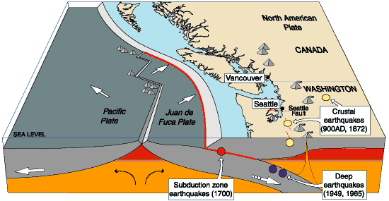
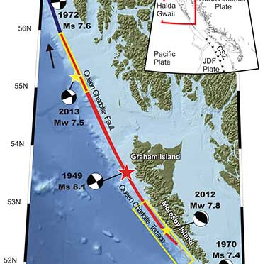
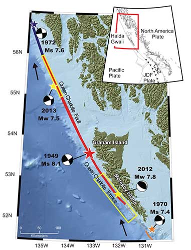
A “devastating megathrust earthquake” could hit Haida Gwaii sometime in the future, according to Canadian and US studies carried out after the magnitude 7.8 earthquake off Haida Gwaii on Oct. 27, 2012 and the 7.5 magnitude quake off Craig, Alaska, a few weeks later on Jan. 5, 2013.
The 2004 Indian Ocean earthquake and the 2011 Tōhoku earthquake in Japan, both accompanied by major tsunamis are recent examples of “great” (higher than magnitude 8.0) megathrust earthquakes. Most of the concern on the west coast has been the likelihood of a megathrust earthquake on the Cascadia Fault on the Juan de Fuca plate that stretches from northern California to the middle of Vancouver Island.
The 2012 Haida Gwaii main shock was the second largest seismic event in Canada since the establishment of a modern seismograph network. The first was the 1949 Haida Gwaii/Queen Charlotte earthquake with a magnitude of 8.1 That 1949 Haida Gwaii earthquake was a strike-slip event, where the plates move side-to-side, similar to the 1906 San Francisco earthquake and other quakes on the San Andreas Fault in California.
The 2012 Haida Gwaii earthquake is characterized in the studies as a “mini-megathrust” event, where part of the crust is pushed upward, meaning that a larger megathrust could have much more destructive consequences from both the earthquake and a possible tsunami.
A diagram of the situation off Haida Gwaii that triggered the October 2012 “mini megathrust” earthquake seen at the lower centre, while the 1949 slip strike earthquake is seen at the top. (Bulletin of the Seismological Society of America)
Complex system of faults
The new studies show that the Pacific and North America plate boundary off the coast of British Columbia and southeastern Alaska creates a system of faults capable of producing very large earthquakes. The scientists conclude that while the two earthquakes in 2012 and 2013 released strain built up over years on the tectonic plates, those events did not release strain along the Queen Charlotte Fault off the west coast of Haida Gwaii. That means the fault remains the likely source of a future large earthquake.
Map showing the pattern of earthquakes along the Queen Charlotte Fairweather Fault system and the location of the Queen Charlotte Terrace. (Bulletin of the Seismological Society of America)
A special issue of the Bulletin of the Seismological Society of America (BSSA), released Monday, April 6, 2015, contains 19 scientific and technical papers, outlining the results of the work carried out over the past two years.
The team estimated the rupture dimension of the 2012 Haida Gwaii earthquake to be about 120 kilometres long at a depth of about 30 kilometres.
The Craig earthquake ruptured the Queen Charlotte fault over a distance of more than 100 kilometres and at a depth of about 20 kilometres.
The two areas are joined in what is called the Queen Charlotte Fairweather Fault System. To the south the Queen Charlotte Fault also interacts with the Juan de Fuca plate that stretches from Vancouver Island to northern California.
“The study of these two quakes revealed rich details about the interaction between the Pacific and North America Plates, advancing our understanding of the seismic hazard for the region,” said Thomas James, research scientist at Geological Survey of Canada.
Two faults off Haida Gwaii
The studies conclude that the interaction between the plates off Haida Gwaii is much more complex than previously believed. Before the 2012 earthquake, the Queen Charlotte Fault, a strike-slip fault similar to the San Andreas Fault in California, was believed to be the dominating tectonic structure in the area. The 2012 tremor confirmed the existence of a previously suspected thrust fault beneath what is called the “Queen Charlotte Terrace,” to the west of the Queen Charlotte Fault, where the Pacific plate is sliding at a low angle below the North American plate.
The Queen Charlotte Terrace, which is about a kilometre below the surface of the ocean, is built up of layers of sediment, several kilometres thick, scraped off the oceanic plate as it subducts under the North American plate. It may also include some fragments of oceanic crust. For most of the terrace, it is “present as a clearly defined linear feature,” but the study adds: “north of about 53.5° N, a complex pattern of ridges and valleys appears.”
The earthquake was “essentially a mini-megathrust earthquake along the dipping plate interface of a subduction system,” one of the scientific papers says. The epicenter of the Haida Gwaii main shock was located about five kilometres landward (northeast) of the Queen Charlotte Fault. That probably means that the rupture was near the bottom of the locked plates, where the plate motion’s side to side movement is also thrusting downward. Significant aftershocks appeared to cluster on the periphery of the main rupture zone with most of the aftershocks occurring seaward to the west.
The scientists used GPS observations of crustal motion to locate the earthquake’s rupture offshore to the west of Haida Gwaii.
The situation off Haida Gwaii is complex because while the Pacific plate is converging with the North American plate at a rate of 15 to 20 millimetres a year, at the same time the two plates are slipping by each other toward the north northwest at angle of about 20 degrees at a rate of about 50 millimetres a year.
Honn Kao, a seismologist with the Geological Survey of Canada said, “This was an event the thrust interface of the plate boundary system, confirming that there is a subduction system in the Haida Gwaii area.
“The implication of a confirmed subduction zone is that in addition to the Queen Charlotte Fault, we now have another source which can produce devastating megathrust earthquakes in the area,” said Kao.
The study of the Haida Gwaii tremor looked at the causative faults, the rupture processes and depths of the main shock and sequence of strong aftershocks.
The Haida Gwaii earthquake generated a significant tsunami that left deposits indicating run-up exceeding 3 metres (maximum 13 metres) in a number of bays and inlets along about 230 kilometres along the west coast of Haida Gwaii. In Hawaii, a 0.8 metre wave was measured on a tide gauge.
In Queen Charlotte City perceptible shaking lasted for one and half to two minutes, with very strong shaking for about 30 seconds. The earthquake was felt as far away as Yukon Territory, Alberta, and Montana.
The study says “Damage was limited, in part owing to the sparse population, but also because of the seismic resistance of the generally low rise, wood-frame buildings on the islands. Felt intensities were at expected values close to the source zone, but regional intensities were smaller than predicted.”
The Haida Gwaii rupture also shook southeastern Alaska. The northwest direction of ground motion then may have influenced the timing of the Craig earthquake a few weeks later in January 2013. That earthquake occurred farther north in southeast Alaska, where relative plate motion is nearly parallel to the Queen Charlotte fault.
Aftershocks
.
Map showing the pattern of aftershocks following the October 2012 Haida Gwaii earthquake. (Bulletin of the Seismological Society of America)
The Haida Gwaii aftershocks clustered around the periphery of the rupture zone, both on the seaward and landward side of the plate boundary and reflected what the study calls “normal faulting behavior–caused by the bending, extending or stretching of rock– rather than the thrust faulting of the main shock.” The pattern of aftershocks is similar to those observed after the 2011 Japanese megathrust earthquake.
“Our observations of normal faulting imply that the main shock of the Haida Gwaii earthquake dramatically altered the stress field in the rupture zone, especially in a neighboring region,” Kao said.
The distribution of aftershocks occurred to the north of a previously identified seismic gap where large earthquakes have not occurred in historic times. The gap is located to the south of the where 1949 magnitude 8.1 Queen Charlotte earthquake ruptured.
Though the Haida Gwaii earthquake may have activated some part of the Queen Charlotte Fault, Kao said, it was limited and did not relieve stress along the seismic gap.
The study concludes:
The Haida Gwaii event confirmed substantial seismic and tsunami hazard from large thrust events on the plate margin along the southern Queen Charlotte fault. It occurred where relatively young oceanic lithosphere under thrusts North America and in some ways is an analog for the much larger megathrust earthquakes known to occur on the Cascadia subduction zone to the south, where the young Juan de Fuca plate and other small plates subduct beneath North America. The Haida Gwaii earthquake had a complex pattern of main shock rupture and aftershocks and a large tsunami.
Further study needed
The Geological Survey of Canada plans further studies to understand the formations off Haida Gwaii.
One question to ask is if there are any records of major earthquake events in the past history of Haida Gwaii. The study notes that the impact of the tsunami was relatively minor “in this region with steep rocky coastlines.” That means there are limited sources of coastal sediments that can be checked for past events. It adds: “Low-elevation lakes, ponds, and bogs may offer the best opportunities for paleotsunami studies” warning that large earthquakes in the past that produced tsunamis may have left little evidence in the “paleoseismic record of Haida Gwaii and similar settings worldwide.”
Megathrust earthquakes occur at subduction zones at destructive plate boundaries where one tectonic plate is subducted (forced underneath) by another. These interplate earthquakes are the planet’s most powerful, with moment magnitudes that can exceed 9.0. Since 1900, all earthquakes of magnitude 9.0 or greater have been megathrust earthquakes. During the rupture, one side of the fault is pushed upwards relative to the other, and it is this type of movement that is known as thrust. The displacement of the ocean in a thrust can trigger a tsunami.
Transform fault
A transform fault is one where the motion is predominantly horizontal. Those faults end abruptly and are connected on both ends to other faults, ridges, or subduction zones. The best-known (and most destructive) are those on land at the margins of tectonic plates. Transform faults are the only type of strike-slip faults at plate boundaries show strike-slip or side-to-side in movement.
Queen Charlotte Terrace
The Queen Charlotte Terrace is a 25 kilometre wide zone of built up marine sediment immediately west of the active Queen Charlotte fault. The crust is about 12 kilometres thick at the terrace. On Haida Gwaii, the earth’s crust is 18 kilometres thick at the eastern edge. On the BC mainland the crust is in excess of 30 kilometres thick.
Historic earthquakes.
The 1949 Haida Gwaii quake was one of the largest in the recorded history of North America.
The largest known earthquake along the coast was the megathrust event on the Cascadia fault on January 26, 1700 where the Juan de Fuca plate ruptured for about 1,000 kilometres along from what is now northern California to Vancouver Island, estimated at magnitude 9.0. The dating is based on a tsunami that hit Japan that had no associated local earthquake as well studies of tree rings from the remains of trees downed in the tsunami.
A US-based engineering and consulting firm, Black & Veatch has issued an optimistic outlook for liquified natural gas exports from both Canada and the United States.
Looking at the the number of LNG export licenses issued to projects “that are likely to proceed,” Black & Veatch raised its forecast for LNG exports by 2020 from the U.S. and Canada to 10 to 14 billion cubic feet per day (Bcf/d).
The report mainly concerns the United States, where the race for LNG exports is as fierce as it is in Canada.
“Tens of billions of dollars in capital are targeted for the seven LNG export terminals currently granted licenses by the U.S. Department of Energy (DOE),” said Deepa Poduval, Principal Consultant with Black & Veatch’s management consulting business. “Infrastructure construction, real estate transactions and other services associated with these projects are expected to spur significant levels of economic activity throughout the value chain.”
As far as Canada is concerned, Poduval said, “proposed projects continue to suffer from regulatory and environmental delays, high costs and fiscal uncertainty that have hindered development on all but a couple of frontrunners.”
The report was based on experts surveyed by the company. Respondents were asked to select their expectation of the volume of natural gas that will be exported from the United States and Canada as LNG by 2020.
Nearly 37 percent of respondents said they believed exports would total more than 6 Bcf/d by 2020. In 2013, less than 25 percent of respondents expected exports at this level. In 2014, 60 percent of respondents said they expected LNG exports to be less than 10 Bcf/d by 2020. Less than 7 percent of respondents put the figure at more than 10 Bcf/d.
Poduval said that as less expensive U.S. gas becomes more viable, Asian buyers are increasingly pushing back on higher cost supplies from their suppliers in Asia, Australia and the Middle East, Poduval said.
This pushback is stalling some of the more expensive LNG projects in Canada, Australia and East Africa, with Asian buyers holding back on long-term purchase commitments from these projects in pursuit of more favorable price terms… One of the dangers for U.S. LNG exports continues to be that they could shrink the very price spread that makes them attractive.
Poduval said the first trains at Sabine Pass in Louisiana are expected to go online starting in the fourth quarter of 2015.
Poduval noted the announcement of the 30-year $400 billion agreement for Russia to supply natural gas to China via a new pipeline was considered by some as the “Holy Grail” of international natural gas agreements following stalemated negotiations for more than 10 years between the two countries.
The deal could provide much-needed market diversity for Russia, which exports 80 percent of its natural gas to an increasingly unfriendly Europe that is pursuing other sources of supply. In addition, Russia would potentially supplant some LNG demand from China by supplying about 3.5 Bcf/d of natural gas under this agreement.
Her report also says that an Alaska LNG pipeline project that has been on and off for the past 30 years is now in a pre-FEED (Front End Engineering and Design) stage.
If it goes ahead, the project, which would be the largest in North America, with a capital cost estimate of $45 billion to $65 billion, will bring gas from the North Slope along an 800-mile pipeline to south-central Alaska, where it will be liquefied for shipping to Asian markets.
“But the marketplace continues to be subject to geopolitical events and regional economics,” Poduval said.
Royal Dutch Shell has finally ditched plans for a new $US20 billion-plus liquefied natural gas project in Queensland,making it the latest casualty of the oil price slump.
Global chief executive Ben van Beurden said the proposed greenfield Arrow LNG project with PetroChina was “off the table”, while other ventures would be slowed as priority was given instead to Shell’s North American LNG projects.
“We are prioiritising North America LNG options in that timeframe, LNG Canada and Elba,” he explained, referring to Shell’s LNG export projects in western Canada and the US state of Georgia.
Shell is also a partner in the Woodside Petroleum-led Browse floating LNG project, the Sydney Morning Herald reported. Woodside recently announced it will buy Apache’s stake in the Chevron-led Kitimat LNG project. Shell says:
the timing for starting engineering and design had already been deferred by six months to mid-2015. While the Shell chief executive’s words place some uncertainty whether the oil major wants to proceed in that timeframe, the company has still listed Browse among final investment decision “choices” for the 2015-16 period.
The Douglas Channel project, which contemplates a floating LNG project at the old log sort half way between Kitimat harbour and the Chevron-led Kitimat LNG project at Bish Cove is a now partnership between EXMAR, “an independent Belgium-based company with 35 years’ experience in LNG shipping,” EDF Trading (“EDFT”) a subsidiary and wholesale market operator of Electricite de France S.A., an international energy company with over 39 million customers and AIJVLP, “a limited partnership between AltaGas Ltd. (“AltaGas”) and Idemitsu Kosan Co.,Ltd. (“Idemitsu”). Idemitsu is a Japan-based global leader in the supply of energy and petroleum. AltaGas is the parent company of Pacific Northern Gas which supplies consumers in Kitimat.
The news release says the “Consortium has also executed long-term lease agreements with the Haisla Nation regarding land and water tenure, and with Pacific Northern Gas Ltd. (PNG) for long-term pipeline capacity to supply gas.”
On Monday, October 20, 2014, the Minister of Fisheries and Oceans, Gail Shea, stood in the House of Commons during Question Period and proved she is not up for the job.
Answering questions from Opposition MPs about the incident of the Russian container ship, Simushir, which drifted dangerously close to the coast of Haida Gwaii, Shea got up and read a prepared script, a script with answers which ignored centuries of the laws and custom of the sea, as well as Canada’s own laws and treaty obligations, answers probably written by what are now known as “the kids in short pants” in the Prime Minister’s Office.
There was a time in this country when some ministers of the Crown took their responsibilities seriously. That idea that has decayed over the years and now has been gutted by the adminstration of Stephen Harper. As Ottawa pundits have noted recently, only a small handful of cabinet ministers in the Harper government have any real responsibility and only those are permitted to answer questions by themselves in the Commons. According to most Ottawa insiders, the less important ministers, like Shea, are basically told what to do by the prime minister’s office.
Gail Shea, Minister of Fisheries and Oceans, visited the Canadian Coast Guard Ship Leonard J. Cowley on Friday, December 6, 2013, to examine the fast rescue craft launching mechanism for offshore fishery patrols with Regional Director, Fleet, Stephen Decker and Captain Kerry Evely, Commanding Officer. The Cowley conducts fisheries patrols and monitors fishing activities under Canada’s commitment to the Northwest Atlantic Fisheries Organization. (DFO)
If the House of Commons under Harper could fall any lower, Shea’s attitude (or more likely the PMO’s attitude) on ship and coastal safety takes the Commons and ministerial responsibility to a new low—the bottom of the sea.
Nathan Cullen, NDP MP for Skeena Bulkley Valley, who represents Haida Gwaii first asked. “Mr. Speaker, on Friday, a Russian ship carrying more than 500 million litres of bunker fuel lost all power just off the coast of Haida Gwaii.The Canadian Coast Guard vessel, the Gordon Reid, was hundreds of kilometres away, and it took almost 20 hours for it to reach the drifting ship. Thankfully, favourable winds helped keep the ship from running aground, and a private American tugboat eventually towed it to shore. Is the minister comfortable with a marine safety plan that is based on a U.S. tugboat and blind luck in order to keep B.C.’s coast safe?”
Shea responded.
“Mr. Speaker, luck had nothing to do with the situation. The Russian ship lost power outside Canadian waters in very rough weather. The private sector provides towing service to the marine industry. We are grateful that the Canadian Coast Guard was able to keep the situation under control in very difficult conditions until the tug arrived from Prince Rupert.”
Cullen tried again:
“Mr. Speaker, if the government really wanted to show its gratitude to the Canadian Coast Guard maybe it would not have cut $20 million and 300 personnel from its budget. Even after the Gordon Reid arrived, its tow cable snapped three times. The Russian ship was only about a third as big as the huge supertankers that northern gateway would bring to the very same waters off the west coast. How can Conservatives, especially B.C. Conservatives, back their government’s plan to put hundreds of oil supertankers off the B.C. coast when we do not even have the capacity to protect ourselves right now?”
Shea replied: “Mr. Speaker, this Russian ship lost power outside of Canadian waters. The Canadian Coast Guard responded and kept the situation under control, under very difficult conditions, until the tug arrived from Prince Rupert.
We as a government have committed $6.8 billion through the renewal of the Coast Guard fleet, which demonstrates our support for the safety and security of our marine industries and for our environment.”
Next to try was Liberal MP Lawrence MacAulay from Cardigan.
“Mr. Speaker, the Russian container ship that drifted off the west coast raises serious concerns about the response capability of the Canadian Coast Guard. This serious situation was only under control when a U.S. tugboat arrived.”
Again Shea read her script: “This Russian ship lost power outside Canadian waters. On the west coast, the private sector provides towing services to the marine industry.’
The final attempt by Liberal Joyce Murray, from Vancouver Quadra, also led to a scripted answer. “ this was a private towing vessel that came to tow the vessel that was in trouble.”
Shea’s answers, especially her repeated reference to “territorial waters” set off a series of “What the…?” posts on Twitter from west coast mariners and sailors, wondering if Shea knew anything about maritime law.
The first question one must ask was Shea actually not telling the whole truth to the House of Commons (which is forbidden by House rules) when she said the Simushir was outside Canadian waters? The Haida Nation, in a news release, (pdf) says the Simushir was “drifting about 12 Nautical Miles North West of Gowgaia Bay located off Moresby Island off Haida Gwaii.”
International law defines territorial waters as a belt of coastal waters extending at most 12 nautical miles (22.2 km; 13.8 mi) from the baseline (usually the mean low-water mark) of a coastal state.
As Shea’s own DFO website says Canada has exercised jurisdiction over the territorial sea on its east and west coasts out to 12 nautical miles since 1970, first under the Territorial Sea and Fishing Zones Act and now under the Oceans Act. The baselines for measuring the territorial sea were originally set in 1967. While the exact position can and should be confirmed by the ship’s navigation logs and GPS track, it is clear that the container vessel could have been at one point after it lost power within Canada’s territorial waters.
Even if the Simushir wasn’t exactly within territorial waters, the ship was in what again Shea’s own DFO website calls the “contiguous zone “an area of the sea adjacent to and beyond the territorial sea. Its outer limit measures 24 nautical miles from the normal baseline zone.” In any case, the Simushir was well within what Canada says is its “exclusive economic zone” which extends 200 nautical miles from the coastal baseline.
Law of the Sea
So here is the first question about Shea’s competence.
How could she not know that the Simushir was well within Canadian jurisdiction, as defined by her own department’s website? Even if the minister hadn’t read the departmental website, wasn’t she properly briefed by DFO officials?
The second point, is that whether or not the Simushir was in actually in Canada’s territorial waters is irrelevant. Custom going back centuries, and now the United Nations Convention on the Law of the Sea and even the Canada Shipping Act all require the master of a capable vessel to render assistance once that vessel receives a distress call or sees that another vessel is in distress.
… the master of a ship at sea which is in a position to be able to provide assistance, on receiving a signal from any source that persons are in distress at sea, is bound to proceed with all speed to their assistance, if possible informing them or the search and rescue service that the ship is doing so.
And the Canada Shipping Act requires
Every qualified person who is the master of a vessel in any waters, on receiving a signal from any source that a person, a vessel or an aircraft is in distress, shall proceed with all speed to render assistance and shall, if possible, inform the persons in distress or the sender of the signal.
The master of a vessel in Canadian waters and every qualified person who is the master of avessel in any waters shall render assistance to every person who is found at sea and in danger of being lost.
Note the phrase any waters. Not just in Canadian territorial waters as the Shea, the minister responsible for the ocean seemed to imply in her Commons answers.
That once again calls into question Shea’s fitness to be a minister of the Crown.
If she did not know about the UN conventions on the law of the sea, of which Canada is signatory, or the Canada Shipping Act, she is not up for the job as Minister of Fisheries and Oceans.
If, as the minister responsible for oceans, she knew the law and was told by the PMO to mislead the House of Commons, she is is irresponsible and MPs should ask the Speaker if she actually broke the rules of the House.
Regulation Seven of the Annex on Search and Rescue Services states
Each Contracting Government undertakes to ensure that necessary arrangements are made for distress communication and co-ordination in their area of responsibility and for the rescue of persons in distress at sea around its coasts. These arrangements shall include the establishment, operation and maintenance of such search and rescue facilities as are deemed practicable and necessary, having regard to the density of the seagoing traffic and the navigational dangers, and shall, so far as possible, provide adequate means of locating and rescuing such persons.
Note that the regulation does not say within territorial waters, but “around its coasts.”
Rendering assistance
Canada has always rendered assistance to distressed vessels not just up and down the coast but around the world. Take the case of HMCS Chartlottetown. On February 3, 2008, HMCS Chartlottetown on anti-piracy and anti-terrorist patrol in the North Arabian Sea, spotted a rusty barge with some men stranded on the deck. It turned out the men were from Pakistan and that the vessel towing the barge had sunk with all hands, leaving only the men on the barge alive. The North Arabian Sea is far out side Canadian territorial waters.
In February, 2008. the crew of HMCS Charlottetown rescued the crew of a Pakistani barge that was drifting in the North Arabian sea after the tug that was hauling the barge sank. (Cpl Robert LeBlanc,/Canadian Forces Combat Camera)
On must wonder then if the Harper Government, or at least Minister Shea is suggesting that this country ignore centuries of maritime law and custom and, in the future, pass that barge by because it was not in Canadian waters?
Perhaps buried in the next omnibus bill we will see the Harper Government restrict rescue at sea to Canadian territorial waters. Farfetched? Well that is what Minister Shea’s answer in the Commons seems to suggest.
Given the cutbacks to the Coast Guard services over the past few years, and if there are going to be large tankers, whether LNG or bitumen, on the west coast, it is an open question whether or not the Harper government has actually made those “arrangements shall include the establishment, operation and maintenance of such search and rescue facilities as are deemed practicable and necessary, having regard to the density of the seagoing traffic and the navigational dangers, and shall, so far as possible, provide adequate means of locating and rescuing such persons.”
Now comes the question of the use of the tug Barbara Foss and the two Smit tugs that later joined to tow the Simushir into Prince Rupert harbour.
It is the responibility of the owner or manager of a disabled vessel, large or small, to contract with a tug or towing service to safely take it back to port. But, and it’s a big but, the tow begins only when it is safe to do so, if there is a danger of the ship foundering, sinking or running aground, it is the obligation of all the responding vessels to render assistance, not just the tug contracted to do the job.
(There are reports that the Simushir owners chose to hire the Barbara Foss rather than the heavy duty Smit tugs available at Prince Rupert. Jonathan Whitworth, CEO of Seaspan told Gary Mason of The Globe and Mail that there are about 80 boats on the west coast, capable of heavy-duty towing, but noted that as in the case of the Simushir, those vessels may not be available when needed)
While around the Lower Mainland of BC, even a small boat that has run out of gas or has engine trouble can get commercial assistance from many service providers, the same is not true of the north coast, or at Haida Gwaii, where are no such regular services. Seapan’s Whitworth told The Globe and Mail there is often a 6,000 horsepower log hauling tug that works off Haida Gwaii. but he also noted that it would be too expensive to have a tug permanently moored on the archipelago.
That means mariners who run out of gas or have engine trouble, say on Douglas Channel, have to call Prince Rupert Coast Guard radio and request assistance either from nearby vessels or from the volunteer Royal Canadian Marine Search and Rescue service. RCMSAR policy says that a the rescue boat will not tow a vessel if “commercial assistance is reguarly available.” If commercial assistance is not available RCMSAR is only obligated to tow the boat as far as a “safe haven,” where the boat can tie up safely or contract for that “commercial assistance.”
Here on Douglas Channel the safe haven is usually Kitimat harbour and thus during the summer frequently either a good Samaritan vessel or RCMSAR take the disabled vessel all the way to MK Bay.
Shea’s pat answer to the Opposition questions only betrayed the fact that the east coast minister is woefully ignorant of conditions on the northern coast of British Columbia.
In the old days, a minister who screwed up so badly would be asked to resign. That never happens any more. Ministerial responsibility has sunk to the bottom of the sea.
The bigger picture question seems to be. Why, if the Harper government is so anxious to get hydrocarbons, whether bitumen or natural gas to “tide water” does it keep going out of its way to show its contempt for the people who live on Canada’s west coast?
A note for the voters of Prince Edward Island, where Shea is the member for Egmont. Consider this, if a ship gets into trouble outside the 12 mile limit, trouble that could threaten your beautiful red sandy beaches, you’re likely on your own.