
Three studies of the geology of Douglas Channel are near completion and publication, according to Natural Resources Canada. That news comes as studies, released today, warn of a major megathrust earthquake on the fault west of Haida Gwaii.
Northwest Coast Energy News asked the Geological Survey of Canada if there were any recent updates available after the agency said that a survey had located a “possible fault” on Hawkesbury Island during studies for the Enbridge Northern Gateway Joint Review Panel.
“Devastating megathrust earthquake” a “substantial hazard” for Haida Gwaii, Canada-US study warns
Is Kitimat ready for a “big one?”
Natural Resources Canada responded with a statement: “NRCan continues to conduct research studies in the area, including study of possible faults. Three scientific expeditions have been completed on board Coast Guard research ships. The first two reports are in the final stages of editing, and will be published in the coming months. The third expedition was just completed; therefore the third report will be available later.”
The initial joint survey by the Geological Survey of Canada and Fisheries and Oceans in September 2012, found a tsunami hazard and a possible seismic fault in Douglas Channel near Kitimat.
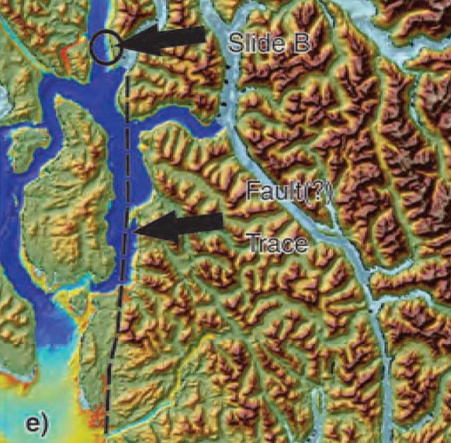
The follow up study by Fisheries and Oceans, released about three weeks after the Haida Gwaii earthquake, in November 2012, identified two slope failure events on the southern end of Hawkesbury Island during the mid-Holecene period, between 5,000 and 10,000 years ago. That study showed that the tsunami from the slope failure reaching Kitimat would have been about 60 centimetres or 23 inches. Hartley Bay would have been hit by a wave height of 7.5 metres or about 25 feet.
More recently there were slope failures nearer to Kitimat. The first slope failure occurred on October 17, 1974, triggering a 2.4 metre tsunami at low tide. Then on April 27, 1975 there was a second slope failure near low tide on the northeast slope of the Kitimat Arm that generated an 8.2 metre tsunami. The 1975 tsunami destroyed the Northland Navigation dock near Kitimat and damaged the Haisla First Nation docks at Kitamaat Village.
Thomas James, of the Geological Survey told Northwest Coast Energy news about the team’s finding on the Haida Gwaii earthquake: “The studies focused on the Haida Gwaii and Craig earthquakes which happened at the Pacific and North American plate boundary, west of Haida Gwaii, so east of Haida Gwaii there’s no comparable plate boundaries that gives rise of historic sieismisticity.”
As well as the fact that recent studies say the mainland margin coastal zone has had very little historical seismicity, it adds no currently active faults have been identified. A study ten years ago identified some very ancient faults which have not been active since the Eocene, about 33 to 56 million years ago.
GPS studies show that in northwestern British Columbia coastal block is moving northeast at the rate of just 5 millimetres a year.
Related links
Kitimat to issue tsunami hazard and evacuation map
Afterearthquake Kitimat must immediately upgrade emergency communications
The earthshaking difference between Enbridge and LNG
Geological Survey of Canada identifies tsunami hazard, possible fault line on Douglas Channel
Scientists identify major Japanses style tsunami hazard for west coast