Special Report: New study identifies earthquake hazards for Hartley Bay, Bella Bella, Kitimat and Terrace

UPDATED with comments from District of Kitimat, Terrace and the Gitga’at Nation

A preliminary seismic hazard assessment by Natural Resources Canada has identified possible earthquake scenarios for the Douglas Channel near Hartley Bay, Terrace and Bella Bella.

The same studies indicate that while Kitimat may not be directly in a seismic zone prolonged earthquakes cause some damage in Kitimat depending on the earthquake and the condition of the soil in certain parts of the District. One model scenario says that in the event of a magnitude 8.0 earthquake off the west coast of Haida Gwaii, given certain soil conditions, there might actually be more damage in Kitimat than on the islands.

Susceptibility to landslides

That assessment, part of the overall the study by the Geological Survey of Canada indicates that the north coast of British Columbia from Prince Rupert to Bella Bella is likely face to “seismically induced ground failure”– mostly landslides.

Overall, the report says that on a scale of 1 to 6 (6 representing the highest
susceptibility), the majority of the west coast of BC “exhibits landslide susceptibility values of 5 to 6, which is significantly higher than the rest of Canada.”

Geological Survey of Canada map showing parts of Canada that are prone to landslides. The BC North Coast study area is outlined by the rectangle. (Geological Survey of Canada)

In British Columbia the landslides are most likely to be triggered by delayed melting of the annual snow pack, heavy rains, bank erosion and site loading and caused long-lasting damning of the river causing “damage to pipelines, rail, and forestry, as well as fish habitats.”

So far no recent landslides along the northern British Columbia coast are known to be caused by earthquakes, the reports say “the existence of numerous landslides strengthens the likelihood of seismically induced ground failures… due to the high levels of seismicity….it is expected that the increased likelihood of strong ground shaking (with long durations) will increase the landslide susceptibility.”

New studies

It was only after the 2012 Haida Gwaii earthquake and with what the Geological Survey of Canada calls “a growing number of on-going and planned infrastructure projects, BC’s north coast is emerging as a region of high strategic importance to Canada’s economy,” that studies began in area where “there has been minimal research to understand earthquake hazards.”

Now that studies have begun the Geological Survey has given the region its own new acronym BCNC (BC North Coast). Haida Gwaii is not part of BCNC, although earthquakes on those islands would likely impact the coast.
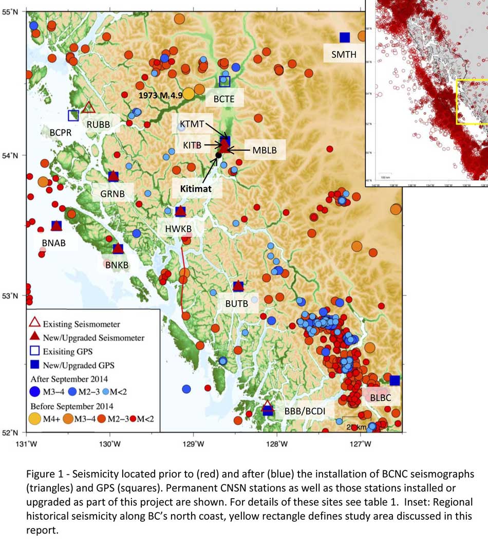
A Geological Survey of Canada map showing the BC North Coast region with earthquakes identified prior to and during recent studies. (Geological Survey of Canada)

The Geological Survey says that historically “the BCNC has been seismically quiescent.” As a result “seismic monitoring and research related to the BCNC has been minimal.” That meant while larger earthquakes were “felt and recorded,” the configuration of the Canadian National Seismograph Network did not allow earthquakes less than approximately magnitude 2.1 to be monitored in northern BC.

Now the Geological Survey is looking at “long-term, continuous monitoring of micro seismicity, combined with geodetic and paleo seismic techniques” that could be used to study at the possibility of large earthquakes, including a possible fault on the lower Douglas Channel.

Since the studies began in August 2014, the Geological Survey identified 145 earthquakes within the study area, many too small to be felt since they are less than magnitude 2.0. Those earthquakes, however, were picked up by the new and improved instrumentation used by the earthquake monitors.

The two reports one on “seismic hazards” and the second on “geohazards” says five “temporary seismonitors”  (download reports from links below) were installed within the BCNC while some older stations were upgraded, saying, “It is expected that these new stations will be aid in locating small earthquakes” that were not previously detected by the existing network. The Geological Survey also installed ground movement monitoring GPS units along the coast.

The use of the term “temporary” raises the question about how much ongoing monitoring is planned.

The study also notes that the current data is not included in the seismic standards in the current National Building Code of Canada, which in turn is based on the Natural Resources Canada Seismic Hazard Map. That may mean that municipalities in the BC North Coast region, in the future, as the seismic studies continue, may have to consider updating building codes, especially in areas of “softer soils” as opposed to harder rock.

“Fault-like structure” on Douglas Channel

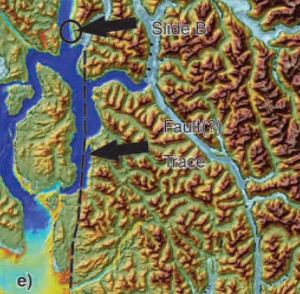
Detail of a map from the Geological Survey of Canada where the red line shows the 60 kilometre possible (still unconfirmed) fault line running from Gribbell Island to Princess Royal Island (Geological Survey of Canada)

Over the years some small earthquakes have also been recorded on what the Geological Survey calls the “recently mapped fault-like structure” on Douglas Channel which was discovered in 2012. The survey is still calling it “fault-like” because it has not yet been confirmed as an active fault. A new map in the study shows that the “fault” runs from the southern tip of Gribbell Island, down the centre of Whale Channel east of Gil Island and then along the western coast of Princess Royal Island.

The study identified “a small, unfelt swarm of earthquakes between magnitude 1.7 and 2.0 between September 13 and 14, 2010 near Gil Island.”

There is also the previously identified ancient Grenville Channel Fault (ancient and believed inactive because it dates from the Cretaceous, the age of the dinosaurs) that runs from along Grenville Channel from Porcher Island in the north to Klemtu in the south which has experienced small earthquakes.

The report says geological studies of the Douglas Channel “fault-like structure” are a priority because, “Should this structure be determined to be an active fault, it would pose significant risk of earthquake-triggered landslides (and subsequent tsunami) from the susceptible Douglas Channel hill slopes.”

Clay and sand in Kitimat

The report also calls for more studies the local geology and soil conditions in the Kitimat Valley. A study back in 1984 by John Clague of Simon Fraser University showed that as the glaciers retreated during the last Ice Age there were “periods of stagnation” resulting in sediments that are thicker than other regions of British Columbia, Clague reported that in parts of Kitimat, the glacial moraine is hundreds of metres thick.

After the glaciers were gone, the sea levels rose and glaciomarine sediments (clay, silt up to 60 metres thick) were deposited until the sea level fell to present-day levels. The report says that as these marine deposits were exposed to fresh water, salts were leached out resulting in saturated, porous sediments, including clay, which are prone to failure. Boreholes in the Kitimat area show that the clay and sediments above the bedrock can range from 17 metres to 106 metres.

The report notes the presence of clay soils “can amplify ground shaking and secondary effects” as happened in November 1988 when there was an earthquake in the Saguenay region of Quebec.

Originally reported as a 6.2 magnitude but later downgraded to 5.9, on Nov. 25, 1988, the major earthquake was centered near the Quebec cities of Chicoutimi and Jonquière, with aftershocks felt as far away as Toronto, Halifax and Boston. The quake lasted for two minutes, catching thousands of people off guard and leaving buildings damaged and power out for hundreds of thousands of Quebecers.

CBC Television reported the earthquake caused a leak of toxic gas at the Alcan Aluminum plant at Jonquière, which was quickly contained. “There was no wind, we were basically lucky,” Alcan spokesman Jacques Dubac told CBC News at the time. 

Terrace earthquake

The report says the most significant event within the BC North Coast study region (which as mentioned doesn’t include Haida Gwaii) was a magnitude 4.9 earthquake approximately 20 kilometers southwest of Terrace on November 5, 1973, which was felt as far as 120 kilometers away, with some minor damage (broken windows and cracked plaster) reported near the epicentre. The main shock at Terrace was preceded by a magnitude 2.5 foreshock four hours before, and followed by a felt magnitude 3.7 aftershock the next day.

Bella Bella at risk

Another area most at risk, according to the report, is southern part of the BC North Coast zone, near Bella Bella, which is close to the northern section  Cascadia Subduction Zone  a “1,000 kilometre long dipping fault that stretches from Northern Vancouver Island to Cape Mendocino California” which one day will cause a major earthquake along the fault.
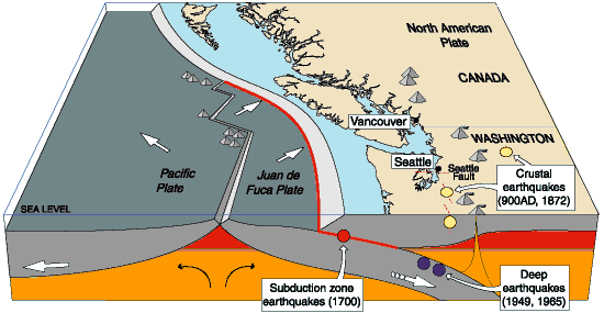
Cascadia subduction zone (USGS)

The report says that a magnitude 9.0 or higher earthquake in the northern Cascadia Subduction zone close to Bella Bella would be similar to the March 2011 earthquake in Japan and the 1964 Good Friday earthquake in Alaska.

For the northern part of the BC North Coast region, hazards could come from either a major earthquake off Haida Gwaii or a similar earthquake in south-eastern Alaska.

The greatest hazard would come from “long period” earthquakes greater than magnitude 6.75 with an epicentre between 300 and 350 kilometers away where the shaking lasts longer than one second.

The Geological Survey modeled three possible scenarios for major earthquakes in the BC North Coast Region.

Model #1. A magnitude 8.0 Earthquake at Haida Gwaii

The Geological Survey Canada model for an 8.0 magnitude earthquake west of Haida Gwaii. The possible damage is colour coded in the table below the map according to the Modified Mercalli Intensity Scale (Geological Survey of Canada)
The Geological Survey Canada model for an 8.0 magnitude earthquake west of Haida Gwaii. The possible damage is colour coded in the table below the map according to the Modified Mercalli Intensity Scale.  The red polygon represents the area of possible rupture in the model with the star representing the epicentre. (Geological Survey of Canada)

The model looked at a “plausible maximum predicted” magnitude 8.0 thrust fault earthquake off the west coast of Haida Gwaii which would be twice as strong in the fault area as the 7.8 quake on October 28, 2012 (Remember Magnitudes are based on a logarithmic scale. That means for each whole number higher, the amplitude of the ground motion recorded by a seismograph goes up ten times so magnitude 8 earthquake would result in ten times the ground shaking as a magnitude 7 earthquake)

For a short period earthquake, the report estimates that there would be minimal damage on Haida Gwaii similar to the damage from the 2012 earthquake with little or no damage on the BC North Coast.

A long duration, long period earthquake that lasted longer than one second and up to three seconds or longer “may effect taller structures and trigger ground failure (that is liquefaction and lateral shaking).” Kitimat would feel that earthquake with the worst shaking in parts of the District with what the report calls “sensitive soils.” Coastal islands would feel double the amount of shaking as would occur in Kitimat.

Model #2. A magnitude 7.2 Earthquake in Douglas Channel
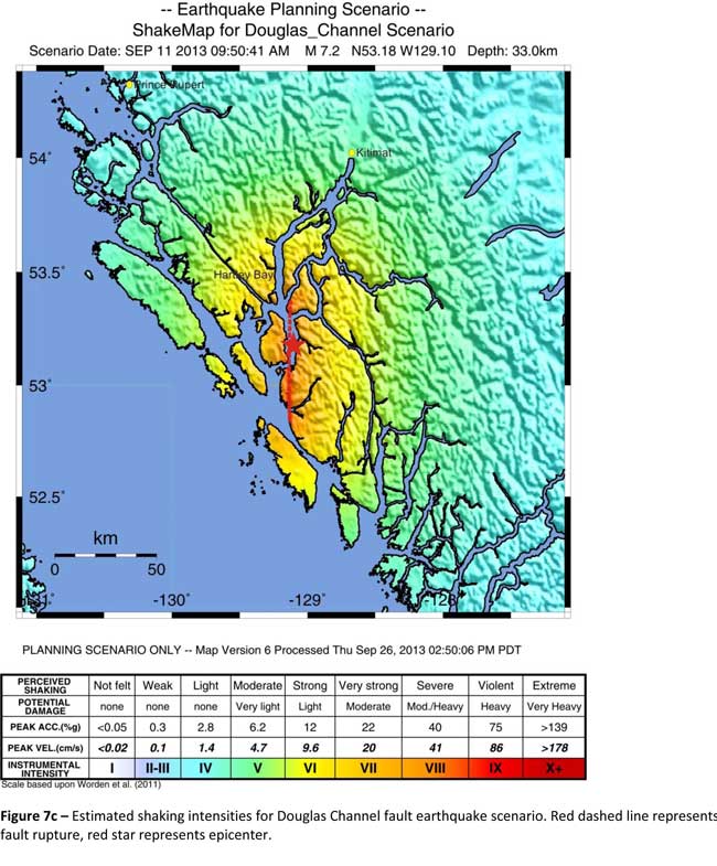
 The Geological Survey Canada model for a 7/2 magnitude earthquake in the lower Douglas Channel. The possible damage is colour coded in the table below the map according to the Modified Mercalli Intensity Scale. The red star represents the possible epicentre. (Geological Survey of Canada)

The Geological Survey Canada model for a 7/2 magnitude earthquake in the lower Douglas Channel. The possible damage is colour coded in the table below the map according to the Modified Mercalli Intensity Scale. The red star represents the possible epicentre. (Geological Survey of Canada)

The second model looked at an earthquake in Douglas Channel based on the “fault like structure” if a slip strike rupture occurred along the entire 60 kilometers of the so far unconfirmed fault, resulting in a 7.2 magnitude earthquake. There would be very strong shaking within 20 kilometers radius of the epicentre, with moderate to heavy damage” in the relatively uninhabited islands, major shaking in Hartley Bay, resulting in very strong to strong damage at Hartley Bay and strong to moderate damage in Kitimat.

That earthquake, however, would be felt across the entire province of British Columbia. The report notes:

The expected effects and impacts of such an earthquake would mimic those of the 1946 magnitude 7.3 Vancouver Island earthquake, which occurred slightly west of Courtney and Campbell River. Shaking due to the 1946 earthquake was felt as far as Prince Rupert, BC to the north and Portland, Oregon to the south. In addition to knocking down 75 per cent of the chimneys in the local area, much of the earthquake-related damage was due to landslides, slumping and liquefaction

Model #3  A magnitude 6.3 Earthquake near Terrace

 The Geological Survey Canada model for an 6.3 magnitude earthquake southwest of Terrace. The possible damage is colour coded in the table below the map according to the Modified Mercalli Intensity Scale. The red polygon represents the area of possible rupture in the model with the star representing the epicentre. (Geological Survey of Canada)

The Geological Survey Canada model for an 6.3 magnitude earthquake southwest of Terrace. The possible damage is colour coded in the table below the map according to the Modified Mercalli Intensity Scale. The red polygon represents the area of possible rupture in the model with the star representing the epicentre. (Geological Survey of Canada)

On May 11, 1973, a magnitude 4.7 shallow earthquake took place about 20 kilometers south west of Terrace, on the south side of the Skeena roughly across from the Shames mountain area. The earthquake was felt up to 120 kilometers away. The report says “The event has not been associated with any geologic features in the area and little is known about its rupture process.” The model estimated the results of a larger earthquake 6.3 magnitude in the same area. The model showed there would be strong to very strong shaking in Terrace, light to moderate shaking in Kitimat and light damage elsewhere in the BC North Coast. Most of the damage would be concentrated in a 20 kilometer zone around the epicentre.

Motivation for study

It was not just potential industrial development that motivated the new studies. The discovery of that possible fault line in the lower Douglas Channel was also a factor. Studies between 2007 and 2009 revealed there were two large submarine slides on Hawkesbury Island during the mid-Holocene sometime between 5,000 and 10,000 years ago 

The cause of the two failures is still unknown but the report says “their proximity to a nearby unmapped fault-like structure suggests that the slides could have been triggered by strong ground shaking from rupture along this structure.”

Another factor was the two well-known landslides occurred in the 1970’s in the Kitimat Arm which generated tsunamis but fortunately they occurred at low tide which decreased the impact. On October 17, 1974 a submarine slide generated a 2.8 metre tsunami. The following year on April 27, 1975, a slope failure on the northeast side of Kitimat Arm (which overlapped the 1974 failure area) displaced an estimated upper limit of 26,000,000 cubic metres of material.

“Watermark observations in Kitamaat Village estimated that the tsunami generated by this slide was up to 8.2 metres high.” The report says that while the trigger of the first event is unknown; the latter event coincided with nearby construction at that time. Modelling of the 1975 slide estimates that given the right conditions the generated tsunami waves could have been as high as 11 metres.

The report also notes that numerous landslides have also been mapped by the BC Department of Forestry in an attempt to improve safety measures for forestry workers.

The report says “The culmination of these studies brings awareness to the significant natural hazards present in the fragile coastal environment of the Coast Ranges.”

Another factor is the geology of the BC coast. The granitic mountains have rugged, steep slopes dissected by an intricate fjord system and dotted with islands of lower elevation. At lower elevations the land is covered by wet, coastal hemlock forests, which could be vulnerable to ground failures whereas higher elevations are characterized by barren rock or mountain hemlock subalpine.
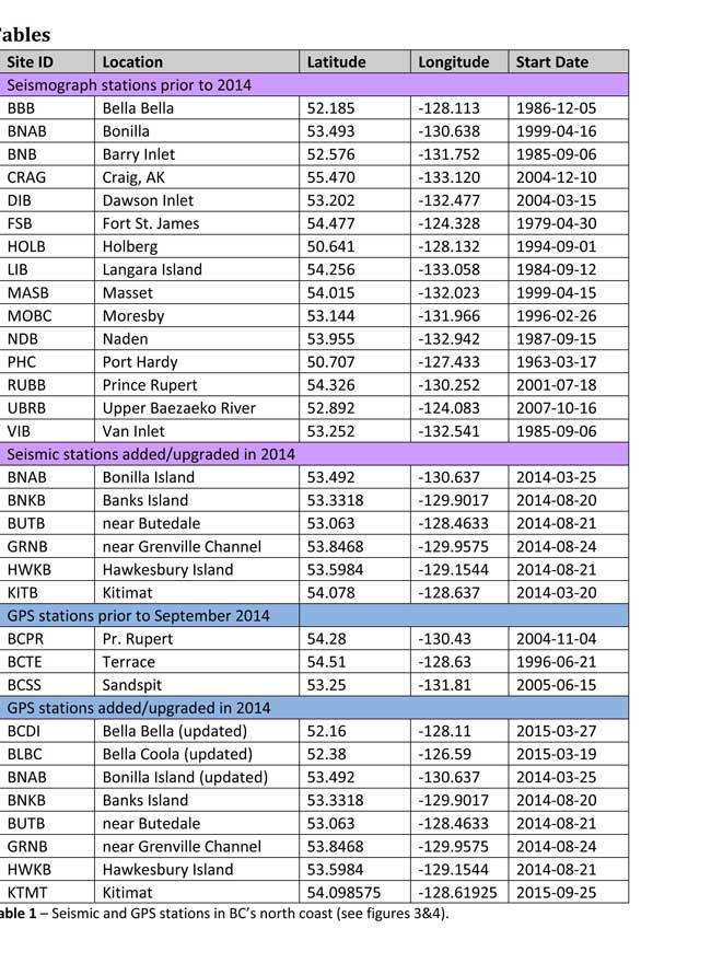
Table of Seismic monitoring and GPS stations in northern BC from the Geological Survey of Canada (Geological Survey of Canada)

The District of Kitimat said it has “not directly studied these issues but we are aware of potential hazards.” The development department has been advised of potential issues and site concerns.

A spokesperson for Terrace mayor Carol Leclerc told Northwest Coast Energy News in an e-mail. “I have reviewed it and distributed it to the relevant department heads. We are aware that historically Terrace has been at risk for experiencing seismic activity due to its location.”

The District of Kitimat did cooperate with National Resources in finding a location for their recently installed seismic equipment.

At Harley Bay, Gitga’at First Nation CEO Ellen Torng said the Gitga’at have been “ working with NRCan on their research in the Douglas Channel and in Hawksbury. NRC has been meeting with First Nations along the coast and have conducted community sessions on their research.

“We hosted one community session here in Hartley Bay and have regular updates from their technical team when they are in the area,” Torng said.

In addition, the District of Kitimat told Northwest Coast Energy News that Community Planning & Development department also provided local land information to geoscientists in the years leading up an international study called Batholiths on land in 2009.

Batholiths are large zones of molten rock that have solidified in the earth’s crust and are believed to play a key role in the formation and growth of continents. The Coast Mountain Range has a large concentration of batholiths, which means Kitimat was an excellent place to study the earth’s crust.

The project, which involved more than 50 scientists from nine Canadian and American universities, was set up to examine how mountain belts form and change over time and why continental mountain ranges are made of granite not basalt. Seismic imaging of the crust and mantle below the mountains required deploying thousands of seismic sensors and recorders, and recorded responses to several man-made detonations. Field work was completed in July 2009, and several scientific papers and dissertations have followed.

The Heiltsuk Nation was unable to respond to a request for comment due to the ongoing crisis from the sinking of the tug Nathan E. Stewart and the resulting spill of diesel fuel and other contaminants near Bella Bella.

Related Commentary: The earthshaking difference between Enbridge and LNG

Download the Geological Survey Studies (PDF)

Baseline Assessment of Seismic Hazards in British Columbia’s North Coast 2016

North Coast Geohazards 2016 Seismology Update

Modified Mercalli Intensity Scale

(from US Geological Survey )

Intensity Shaking Description/Damage
I Not felt Not felt except by a very few under especially favorable conditions.
II Weak Felt only by a few persons at rest,especially on upper floors of buildings.
III Weak Felt quite noticeably by persons indoors, especially on upper floors of buildings. Many people do not recognize it as an earthquake. Standing motor cars may rock slightly. Vibrations similar to the passing of a truck. Duration estimated.
IV Light Felt indoors by many, outdoors by few during the day. At night, some awakened. Dishes, windows, doors disturbed; walls make cracking sound. Sensation like heavy truck striking building. Standing motor cars rocked noticeably.
V Moderate Felt by nearly everyone; many awakened. Some dishes, windows broken. Unstable objects overturned. Pendulum clocks may stop.
VI Strong Felt by all, many frightened. Some heavy furniture moved; a few instances of fallen plaster. Damage slight.
VII Very strong Damage negligible in buildings of good design and construction; slight to moderate in well-built ordinary structures; considerable damage in poorly built or badly designed structures; some chimneys broken.
VIII Severe Damage slight in specially designed structures; considerable damage in ordinary substantial buildings with partial collapse. Damage great in poorly built structures. Fall of chimneys, factory stacks, columns, monuments, walls. Heavy furniture overturned.
IX Violent Damage considerable in specially designed structures; well-designed frame structures thrown out of plumb. Damage great in substantial buildings, with partial collapse. Buildings shifted off foundations.
X Extreme Some well-built wooden structures destroyed; most masonry and frame structures destroyed with foundations. Rails bent.

Prepare now for drastic climate change, UBC study warns First Nations’ fishery, other stakeholders

Fewer salmon; many more sardines.

That’s one of the predictions from a new study from the University of British Columbia, looking at the future of the fishery on the coast.

The study concentrates on the First Nations fishery and warns that aboriginal people could face a catastrophic decline in the harvest of traditional species, especially salmon and herring roe on kelp over the next thirty years, a decline that will also have an equally devastating effect on commercial and recreational fishing.

The main cause of the decline is climate change and the warming of the coastal waters. The study projected “modest to severe declines in catch potential” for all current commercial fisheries along the coast.

The study says that for the First Nations the between $28 million to $36 million in revenue they got from fishing between 2001 and 2010 could fall by up to 90 per cent depending on how the climate changes.

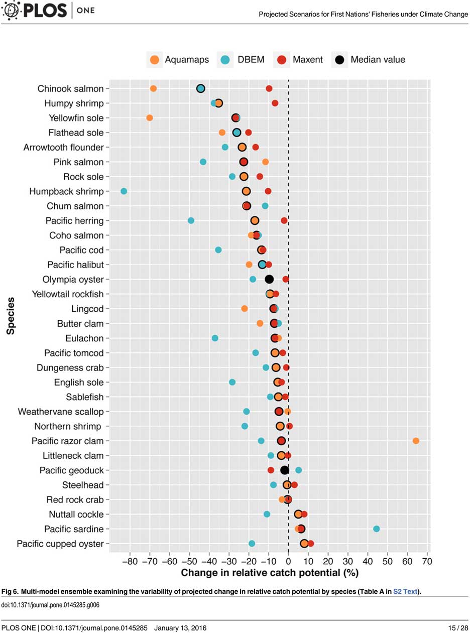
A chart from the UBC study shows possible decline in fish species under different climate scenarios. (PLOS1)

One scenario calls for a decline of up to 40 per cent in chinook and pink salmon.

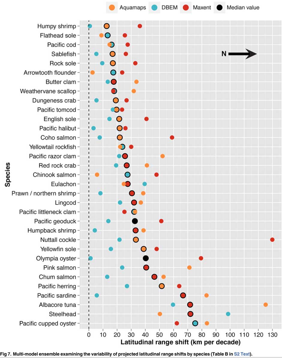
If there is any good news, if you can call it that, the decline will be not as bad in northern coastal waters as it will be the warmer waters near the Lower Mainland and southern Vancouver Island. The range of some species, including salmon, herring, halibut and possibly oolichan will move to farther north along the BC Coast and into Alaskan waters.

That means in time the warming waters will also encourage an increase in other species, including sardines and some clams.

The changing oceans mean that “an increase in the relative abundance of warmer-water species was projected to lead to new or increased opportunities for commercial harvests by 2050.”

The study is urging the First Nations and other stakeholders in the British Columbia fishery to start long term planning immediately to  anticipate changes in the coming decades.

The team of scientists led by Lauren Weatherdon, a graduate student at UBC, noted that while previous studies have looked at the impact of climate change on large-scale commercial fisheries, “few efforts have been made to quantitatively project impacts on small-scale subsistence and commercial fisheries that are economically, socially and culturally important to many coastal communities.”

The study Projected Scenarios for Coastal First Nations’ Fisheries Catch Potential under Climate Change: Management Challenges and Opportunities is published in the online journal PLOS One

The study was conducted in cooperation with the BC First Nations Fisheries Council and looked its seven coastal administrative regions “forming a sample of groups with diverse marine resources, geographical locations, territorial sizes, and treaty statuses.”

Within those regions 16 First Nations participated in the study, some under their treaty councils, including the Council of the Haida Nation, the Tsimshian Nations Treaty Society (including the Gitga’at at Hartley Bay and the Kitselas and Kitsumkalum near Terrace) and the Maa-nulth First Nations. The Heiltsuk First Nation at Bella Bella participated as an independent group.

regioncatchfn

The FNFC’s administrative regions intersect with five distinct ecological regions: the North Coast, comprising the Hecate Strait and Dixon Entrance; Haida Gwaii, which includes the waters surrounding the islands; the Central Coast, including Queen Charlotte Sound, Queen Charlotte Strait, and the southern tip of Hecate Strait; the Strait of Georgia; and the west coast of Vancouver Island (WCVI) .

The study says First Nations are likely to be exposed to different climate-related impacts on fisheries due to the differing ecological and biogeographical characteristics of these regions and to differing traditional and commercial harvests.

The study used a “dynamic bioclimate envelope” computer model to look at the changes to the distribution and relative abundances of the BC coastal species under two climate change scenarios, a high greenhouse gas model where society can’t curb emissions and a low greenhouse gas emission scenarios, depending on how society is able to curb the increase.

The study looked at ocean properties—including sea surface temperature, sea bottom temperature, salinity, oxygen concentration, surface action, and net primary production—using data from the US National Ocean and Atmospheric Administrations’  climate-related earth system model.

Climate change will mean that current species on the BC coast will “shift polewards.”

The study showed that by 2050, there could be declines in 87 of the 98 species in the study.

Greater losses in  what the study calls “species richness” is likely to occur towards the southern coast of British Columbia, falling primarily between 48°N and 51°N. But, overall,  species richness along coastal BC will continue—only with different species.

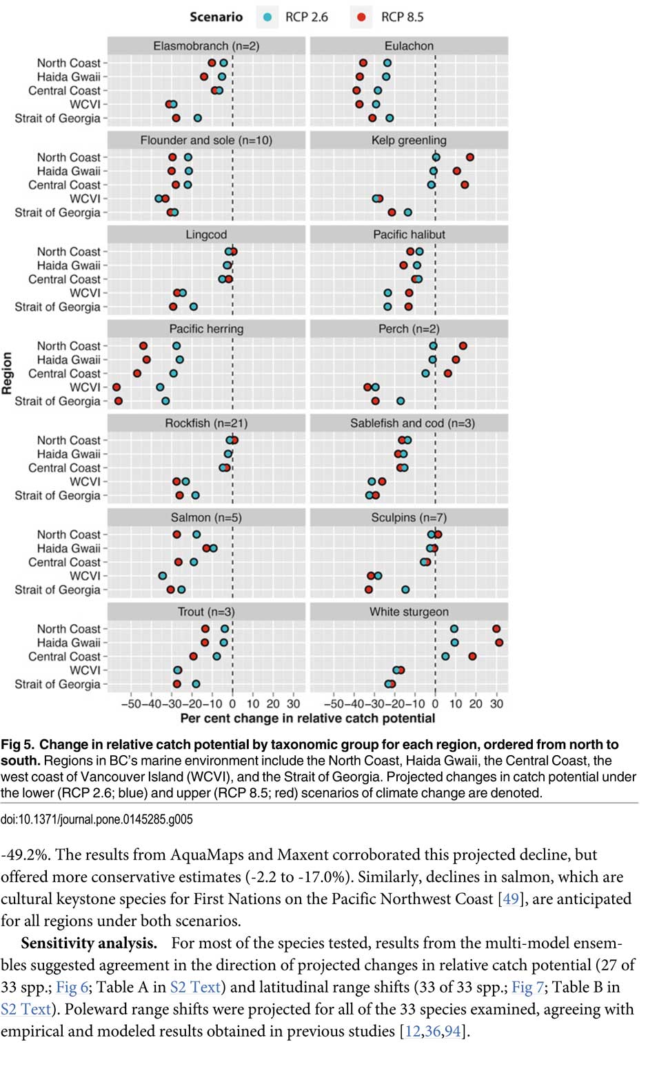
Most significantly the study projects a decline in the overall salmon catch from 17.1 per cent to 29.2 per cent, depending on the region and climate.

All aspects of the herring fishery, including roe herring, spawn-on-kelp, and the food and bait fishery could decline between 28.1 per cent and 49.2 per cent depending on the region.

The future of the oolichan is the most uncertain. One of the models studied projected a further 37.1 per cent decline in the oolichan, while other models called for for a decline between 5 per cent and 6.8 per cent. That will depend on how well, the oolichan already threatened in most regions of British Columbia are able to adapt to warmer waters or find a way to move their range northward.

The study says white sturgeon and Pacific sardines were projected to increase in abundance under both climate change scenarios, while manila clams were projected to increase in abundance by 14.5 per cent in one of the models. The eight remaining species showed little change.

The study suggests that the southern territories (Tsawwassen, Tla’amin, and Maa-nulth First Nations) will likely see a reduction in catch potential between -15.2 per cent and -27.8 per cent depending on how the climate changes.

On the north coast. The Haida and Tsimshian First Nations and those situated along the central or north-eastern coasts of Vancouver Island (Heiltsuk and ‘Namgis First Nations)  would likely see smaller reductions in relative catch for each territory, with estimates falling between -3.2 per cent and -8.2 per cent.

The study shows that for the First Nations along the North and Central Coasts of British Columbia (Gitga’at and Haida, and Heiltsuk and ‘Namgis) there will be neutral or positive shifts in catch potential for white sturgeon, kelp greenling, and two species of perch under both scenarios.

While varying regionally, both scenarios also suggested either a slight cumulative decline or negligible change in catch potential for clams, rockfish, lingcod, and sculpins across the North and Central Coast.

One potential problem the study suggests is that fishers in southern British Columbia may, in the future, try to move north to follow the harvest, leading to potential conflicts.  The cost of travel, may, however, discourage that.

One of the recommendations from the study is that First Nations revive the traditional clam gardens.

Traditional clam beds serve as an ideal example of a method that could be applied to offset climatic impacts through internalized mechanisms, using local cultivation to generate increased productivity by enhancing native habitat rather than redirecting extraction efforts towards other regions or species. Clam gardens constructed in a manner akin to those situated near ancient settlements of the Northern Coast Salish and Laich-kwil-tach First Nations have been found to generate higher clam densities, biomass, and growth rates than non-walled beaches . These benefits were observed for Pacific littleneck clams and butter clams , two clams that are of cultural, economic, and ecological importance to the region Reinstating clam beds in First Nations’ territorial lands has been suggested as a means of simultaneously achieving local conservation and cultural objectives and may thereby provide a politically and ecologically viable option for mitigating climate-related impacts.

The most important recommendation is that the First Nations and other stakeholders start cooperating immediately to offset how the changing climate with affect the fishery:

Management of salmon and herring stocks has been highly contentious due to the myriad of stakeholders who depend upon them, which include First Nations, recreational fisheries, and commercial fisheries….

Aside from fulfilling societal needs, salmon serve as key ecological components of the Pacific Northwest Coast, functioning as the mechanisms by which nutrients are transferred from the ocean to freshwater and terrestrial ecosystems

It says the projections show that a “redistribution of fishing effort” will not “fully offset declines in salmon and herring”

attaining a state of collaboration between First Nations, DFO, and other sectors has the potential to yield beneficial ecological and political results, if implemented correctly. Parallels exist between First Nations’ traditional fisheries management approaches and “modern” approaches (e.g., spatial management, mariculture, selective fishing, fishing closures), with differences arising primarily due to diverging worldviews.

It recommends local application of First Nations’ traditional management strategies to “provide opportunities to collaboratively engage in adaptive ecosystem-based management and to coordinate efforts to attain conservation objectives.”

They give an example of how the Nisga’a Nation have ensured their equal partnership in management by employing traditional fish wheel technology to monitor and assess stocks and by leveraging traditional ecosystem-based management practices that could be applied to plan long-term objectives and management approaches.

It concludes by saying that joint-management will not only work to reduce the impact of climate change but also head off potential conflict.

Through such joint-management regimes, traditional fisheries management strategies could be applied to advance localized research directives and to reduce impacts on stocks under unprecedented environmental change. Moreover, the risk of conflict over declining resources underlines the need to establish common and equitable ground to ensure successful joint management of fisheries, and to leverage collective expertise.

Chart from the study showing which fish species will move north up the coast as the climate changes. (PLOS1)

BC Supreme Court rules province failed to consult First Nations on Northern Gateway

The B.C. government acted improperly and “breached the honour of the crown” when it signed away a provincial review and gave the federal Joint Review Panel for responsibility for assessing the environmental impact of the proposed Northern Gateway pipeline, Madam Justice Marvyn Koenigsberg of the Supreme Court of B.C. ruled Wednesday.

In a largely technical decision,  Justice Koenigsberg ruled that British Columbia must come to its own decision on Northern Gateway. That’s because what is called the “equivalency agreement” that handed the decision over to the federal agency was not “was reasonable or correct for the Province to exercise its discretion.”

She ruled the equivalency agreement “is invalid” and said the project cannot begin until a provincial environmental assessment certificate has been issued.

“The province is required to consult with the Gitga’at about the potential impacts of the project on areas of provincial jurisdiction and about how those impacts may affect the Gitga’at’s aboriginal rights, and how those impacts are to be addressed in a manner consistent with the honour of the Crown and reconciliation,” Koenigsberg ruled.

Read the judgement (pdf)

Justice_Koenigsberg_Coastal-First-Nations-v-British-Columbia-Environment

That may be the final nail in the Northern Gateway’s coffin. The province opposed the project at the JRP because the Northern Gateway had not met the five conditions for heavy oil transport that was set down by the government.

The court ruling comes shortly after British Columbia told the National Energy Board that it also opposed the $6.8-billion Kinder Morgan TransMountain pipeline because, at this point, that project cannot meet BC’s five conditions.

B.C. Justice Minister Suzanne Anton said the province is reviewing the Supreme Court decision.

There are 19 more court challenges to the Northern Gateway and to the Joint Review process, most  before the Federal Court of Canada.

cfn-logo-350

The Gitga’at First Nation and Coastal First Nations which brought the suit in January 2015 say that the ruling means Enbridge pipeline must now face provincial environmental assessment decision, which includes consultation with First Nations across the province.

“Approval of the project falls within federal jurisdiction and this decision from the B.C. Supreme Court does not change that approval or the project’s environmental assessment,” said Ivan Giesbrecht, communication manager for Northern Gateway, in a statement to the CBC.

Northern Gateway says the federal decision stands, and its still working to meet the 209 conditions set out by the NEB, along with the B.C. government’s conditions.

“Northern Gateway and the project proponents, including Aboriginal Equity Partners, remain committed to this essential Canadian infrastructure,” Giesbrecht told the CBC.

But among the 209 conditions attached to the approval by the  Joint Review Panel  Condition 2 said that construction must begin before December 31, 2016.  Under Conditions 20 and 21, Enbridge must have secured commitments for at least 60 per cent of the pipeline’s capacity at least six months before starting construction.

Enbridge still doesn’t have any customers and with the world price of oil below $40 US a barrel, the chances of getting customers are slim.  In its most recent NEB filing on December 21, 2015, Enbridge stated, “Further to its filing of June 29, 2015, Northern Gateway has not executed firm [transportation service agreements] with its prospective shippers.”

Koenigsberg ‘s ruling doesn’t official stop the Northern Gateway as some are celebrating.  Rather the decision means that  British Columbia must  set up its own review process and then come to a decision.  That decision could, in theory, approve Northern Gateway with  conditions just as the Joint Review Panel did.

The news release from the Coastal First Nations goes on to say:

The ruling, which is a major victory for the Gitga’at First Nation, means the equivalency agreement is invalid, that the government must now make its own environmental assessment decision regarding the Enbridge Northern Gateway pipeline, and that it must consult with and accommodate First Nations along the pipeline route about potential impacts to their Aboriginal rights and title.

“This is a huge victory that affirms the provincial government’s duty to consult with and accommodate First Nations and to exercise its decision-making power on major pipeline projects,” said Arnold Clifton, Chief Councillor of the Gitga’at First Nation.

“This ruling is an important victory for our communities and presents another hurdle to the Enbridge Northern Gateway pipeline,” said Chief Marilyn Slett, President of the Coastal First Nations. “It means the province must now sit down with First Nation communities across BC and find ways to address the severe and irreversible impacts of this project.”

The constitutional challenge was brought by the Gitga’at First Nation and the Coastal First Nations, and was argued by Joseph Arvay, Q.C., (and his colleagues Catherine Boies Parker and Tim Dickson at Farris LLP ) one of Canada’s pre-eminent constitutional lawyers and an expert in Aboriginal and administrative law.

“The province has been talking a lot about its opposition to oil pipelines in recent days,” said Art Sterritt, a member of the Gitga’at First Nation. “Now it must put its money where its mouth is and apply the same rigorous standards it advocated for during the Joint Review Panel process, while consulting with every single First Nation who would be affected by this project. We’ve said it before: The Enbridge Northern Gateway pipeline is dead.”

The ruling means that, until the province makes a decision on the Enbridge Northern Gateway pipeline and issues an Environmental Assessment Certificate, none of the approximately 60 permits, licenses and authorizations necessary for the project to proceed can be issued.

New Douglas Channel geological studies near completion

Three studies of the geology of Douglas Channel are near completion and publication, according to Natural Resources Canada. That news comes as studies, released today, warn of a major megathrust earthquake on the fault west of Haida Gwaii.

Northwest Coast Energy News asked the Geological Survey of Canada if there were any recent updates available after the agency said that a survey had located a “possible fault” on Hawkesbury Island during studies for the Enbridge Northern Gateway Joint Review Panel.

“Devastating megathrust earthquake” a “substantial hazard” for Haida Gwaii, Canada-US study warns

Is Kitimat ready for a “big one?”

Natural Resources Canada responded with a statement: “NRCan continues to conduct research studies in the area, including study of possible faults. Three scientific expeditions have been completed on board Coast Guard research ships. The first two reports are in the final stages of editing, and will be published in the coming months. The third expedition was just completed; therefore the third report will be available later.”

The initial joint survey by the Geological Survey of Canada and Fisheries and Oceans in September 2012, found a tsunami hazard and a possible seismic fault in Douglas Channel near Kitimat.

Fault zone map Douglas Chanel
A 2012 map from the Geological Survey of Canada showing the line of a possible seismic fault on Douglas Channel (Geological Survey of Canada)

The follow up study by Fisheries and Oceans, released about three weeks after the Haida Gwaii earthquake, in November 2012,  identified two slope failure events on the southern end of Hawkesbury Island during the mid-Holecene period, between 5,000 and 10,000 years ago. That study showed that the tsunami from the slope failure reaching Kitimat would have been about 60 centimetres or 23 inches. Hartley Bay would have been hit by a wave height of 7.5 metres or about 25 feet.

More recently there were slope failures nearer to Kitimat. The first slope failure occurred on October 17, 1974, triggering a 2.4 metre tsunami at low tide. Then on April 27, 1975 there was a second slope failure near low tide on the northeast slope of the Kitimat Arm that generated an 8.2 metre tsunami. The 1975 tsunami destroyed the Northland Navigation dock near Kitimat and damaged the Haisla First Nation docks at Kitamaat Village.

Thomas James, of the Geological Survey told Northwest Coast Energy news about the team’s finding on the Haida Gwaii earthquake: “The studies focused on the Haida Gwaii and Craig earthquakes which happened at the Pacific and North American plate boundary, west of Haida Gwaii, so east of Haida Gwaii there’s no comparable plate boundaries that gives rise of historic sieismisticity.”

As well as the fact that recent studies say the mainland margin coastal zone has had very little historical seismicity, it adds no currently active faults have been identified. A study ten years ago identified some very ancient faults which have not been active since the Eocene, about 33 to 56 million years ago.
GPS studies show that in northwestern British Columbia coastal block is moving northeast at the rate of just 5 millimetres a year.

Related links
Kitimat to issue tsunami hazard and evacuation map

Afterearthquake Kitimat must immediately upgrade emergency communications

The earthshaking difference between Enbridge and LNG

DFO study on ancient Douglas Chanel tsunamis show minimal impact on Kitimat, devastation at Hartley Bay

Geological Survey of Canada identifies tsunami hazard, possible fault line on Douglas Channel

Scientists identify major Japanses style tsunami hazard for west coast

Is Kitimat ready for a “big one?”

Kitimat Emergency Coordinator Bob McLeod
Kitimat Emergency Coordinator Bob McLeod at the earthquake postmortem Oct. 29, 2012 (Robin Rowland/Northwest Coast Energy News)

Studies of the October 2012 magnitude 7.8 Haida Gwaii earthquake show that the region is vulnerable to a “major megathrust” earthquake along a newly confirmed fault line west of the islands.

That earthquake was felt in Kitimat and Kitamaat Village and a tsunami warning was issued within a few minutes.

So have the District of Kitimat, the Haisla Nation Council or Rio Tinto Alcan changed or upgrading their earthquake and tsunami plans in the past couple of years?

“Devastating megathrust earthquake” a “substantial hazard” for Haida Gwaii, Canada-US study warns

New Douglas Channel geological studies near completion

Bob McLeod, who recently retired as the District of Kitimat’s emergency coordinator, told Northwest Coast Energy News: “I think we’ve done quite a bit. One of the biggest issues in the first one was trying to get information out. We’ve come a long way on that. Whether you reach everyone or not, that’s another thing, because you never reach everybody. One of the critical things to me is getting the information out so you avoid all this Facebook, Twitter speculating and rumour. The communications aspect has improved a hundred fold.

“We did more work on the mapping and planning. Over the course of the last year, there were a lot of meetings with industry and various stakeholders, discussing emergency preparedness in general but touching on some of these other things as well.

“One of the things we did was to try to set up some shelter points. We have an agreement with the Baptist Church, the Catholic Church and the Seventh Day Adventists. They’re strategically located and could be gathering points for the various neighborhoods if necessary.

“We’ve also done quite a lot of work on Riverlodge as a group lodging centre, thinking in terms of an earthquake where there may be damage and you have to move people.

“We did look at the evacuation planning and we’ve had a couple of exercises involving that, looking strategically about how can you move people from certain neighborhoods, asking which neighborhoods would be at the most risk if you ended up with a tsunami situation.

As for tsunamis, McLeod said, “From everything we’ve heard and been told, tsunamis in extremely deep water like that is not going to be as dangerous as one in shallower water, but the possibility is still there.

“The thrusts are the killers when it comes to tsunamis, but there is a very good warning system on the tsunamis. We do get very very rapid feedback on the earthquakes.

“The only danger in that regard is if you have a severe earthquake and you have part of a mountain drop into the salt chuck, you’re going to get a massive wave and you’re going to get no warning whatsoever, like the Moon Bay collapse in the seventies.

“The emergency plan is in good shape. We scheduled a number of exercises last year through training programs.

“One of the things I personally push is personal preparedness. I think as a community, we fail greatly at that. That was evident even during the snowstorm. People are not just prepared to look after themselves, it’s unfortunate. You just have to keep chipping away.”

Last week, Northwest Coast Energy News asked Rio Tinto Alcan and the Haisla Nation Council if either could comment on updated earthquake or tsunami response plans. So we have received no answers.


Related links
Kitimat to issue tsunami hazard and evacuation map

After earthquake Kitimat must immediately upgrade emergency communications

The earthshaking difference between Enbridge and LNG

DFO study on ancient Douglas Chanel tsunamis show minimal impact on Kitimat, devastation at Hartley Bay

Geological Survey of Canada identifies tsunami hazard, possible fault line on Douglas Channel

Scientists identify major Japanses style tsunami hazard for west coast


Sending the Northern Gateway Pipeline to Prince Rupert: A dumb, dumb, dumb idea—and here are the photos to prove it.

There’s a dumb, dumb, really dumb idea that just won’t go away—that Enbridge could solve all its problems if only, if only, it would send the Northern Gateway Pipeline to Prince Rupert.

Enbridge long ago rejected the idea. Before Enbridge updated its website to make  Gateway Facts, to make it slick and more attractive, the old website had an FAQ where Enbridge explained why it wasn’t going to Prince Rupert.

Did you consider running the pipeline to Prince Rupert where a major port already exists?

We considered Prince Rupert and Kitimat as possible locations. We carried out a feasibility study that took into account a number of considerations. The study found that the routes to Prince Rupert were too steep to safely run the pipeline, and that Kitimat was the best and safest option available.

Current proposed route for the Northern Gateway pipeline. (Enbridge)

Here in the northwest even the supporters of the Northern Gateway roll their eyes when they hear the old Prince Rupert story come up again and again – and it’s not just because these people support the Kitimat plans for Northern Gateway, it’s because those supporters (not to mention the opponents) have driven along the Skeena from Terrace to Prince Rupert.

There just isn’t any room for a pipeline. It’s a game of centimetres.

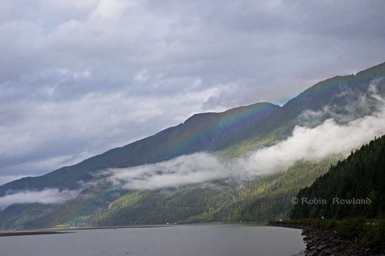
A rainbow hugs the mountains near the Telegraph Point rest area on the Skeena River between Terrace and Prince Rupert, Sept. 29, 2014.  Traffic is seen on the narrow corridor between the mountains and the river (Robin Rowland/Northwest Coast Energy News)
A rainbow hugs the mountains near the Telegraph Point rest area on the Skeena River between Terrace and Prince Rupert, Sept. 29, 2014. Traffic is seen on the narrow corridor between the mountains and the river (Robin Rowland/Northwest Coast Energy News)

Alternatives to Kitimat?

Now the new premier of Alberta, Jim Prentice, who should know better if he’s going to lead that province, is hinting that Kitimat isn’t the only possible solution for the Northern Gateway.

Without specifying Prince Rupert, according to Gary Mason reporting in The Globe and Mail, Prentice was speculating about an alternative to Kitimat.

Asked whether he believes the Gateway terminus should be relocated to Prince Rupert or another destination, Mr. Prentice said, “Everything I’ve heard from the Haisla who live there is they don’t agree with the terminal being in Kitimat.” Is it possible to get First Nations approval if there is no support at the planned terminus site? “It’s pretty tough,” the Premier said.

A couple of days ago, the Prince Rupert’s Mayor Jack Mussallem told The Globe and Mail in Mayor, port authority say no room for Northern Gateway pipeline in Prince Rupert

Prince Rupert has a thriving local fishing industry that employs hundreds of people and is critically important to the local First Nations. He is convinced the community would not be willing to put that at risk.
“Overwhelmingly people in my community are much more comfortable with liquefied natural gas, with wood pellets, with coal, than any oil product,” he said.

The Prince Rupert Port Authority also rejected the idea

A spokesman for the Prince Rupert Port Authority said Wednesday there is currently no room for Enbridge to build at the port even if it wanted to. “We are fully subscribed,” Michael Gurney said. There are two large vacant lots within the port authority’s jurisdiction, but both are locked by other energy companies, earmarked for LNG projects.

So not only is there no room on the road to Prince Rupert, there is no room in Prince Rupert.

Shovel-ready?

Let’s just consider for a moment that if Prince Rupert was the ideal location for the Northern Gateway terminal (which it is not), what would be needed to get the project going today.

The Northern Gateway Joint Review Panel would have be reconstituted or a new JRP created by the National Energy Board. That’s because the bitumen comes from Bruderheim, Alberta, crossing provincial boundaries and thus it’s in federal jurisdiction.

Even under the fast track rules imposed on the NEB by Stephen Harper’s Conservative government, new environmental and social impact studies would be required, starting from scratch. So add another five years of paperwork before a single shovel goes into the ground.

The pipeline would have to cross the traditional territory of First Nations that, so far, have not been part of the negotiations, mostly the Tsimshian First Nation as well as the Nisga’a First Nation which has a treaty establishing local rule over their territory.

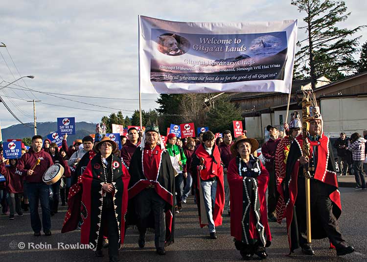
Traditional leaders of the Gitga'at First Nation lead a protest march through the streets of Prince Rupert, February 4, 2012. (Robin Rowland/Northwest Coast Energy News)
Traditional leaders of the Gitga’at First Nation lead a protest march through the streets of Prince Rupert, February 4, 2012. (Robin Rowland/Northwest Coast Energy News)

In February 2012, the largest anti-Enbridge demonstration outside of the Lower Mainland took place in Prince Rupert, with the elders of the Tsimshian First Nation welcoming the elders and members of the Gitga’at First Nation, at Hartley Bay, which had organized the protest.

While Kitimat Council long stood neutral on the issue, the councils at Prince Rupert, Terrace, Smithers as well as the Kitimat Stikine Regional District and the Skeena Queen Charlotte Regional District had voted to oppose the Northern Gateway.

Audio Slideshow; No to Tankers Rally, Prince Rupert, February 4, 2012

The Skeena Route

The Skeena is one of the greatest salmon rivers on the planet. The Petronas LNG project has already run into problems because its planned terminal at Lelu Island would also impact the crucial eel-grass which is the nursery for young salmon leaving the Skeena and preparing to enter the ocean. Note that northern BC is generally in favour of LNG terminals, if the terminals are in the right place, so expect huge protests against any bitumen terminal at the mouth of the Skeena.

When I say there isn’t room for a pipeline along the Skeena, it also means that there isn’t any room for the pipeline corridor right-of-way. Enbridge, in its submissions to the Joint Review Panel, said it requires a 25 metre wide right of way for the pipeline corridor. (For the record that’s just over 82 feet).

Along that highway, as you will see, there’s barely enough room for the CN mainline and Highway 16 (also known as the Yellowhead Highway) and on a lot of places both the highway and the railway roadbed are built on fill along the side of a cliff.

Now I’ve said this all before, two years ago, in a piece for the Huffington Post, Get Over it! A Pipeline to Prince Rupert Is Bust

Albertans’ desperate desire to see the Northern Gateway go to anywhere to what they call “tide water” keeps coming up like the proverbial bad penny. The latest came when Jim Prentice speculated about a new route for the Northern Gateway.

I knew I had an appointment coming up in Prince Rupert on Monday, September 29. So I decided that only way to prove to people sitting in Calgary, Edmonton and Fort McMurray playing with Google Maps that the pipeline to Prince Rupert was a really dumb idea was to shoot photographs to show just why the Northern Gateway will never go to Prince Rupert—at least along the Skeena.

As you drive out of Terrace, you pass two large swing gates (also called by some “Checkpoint Charlie” gates after the Cold War era crossing in Berlin.) At the first rest stop west of Terrace, there are another set of gates at the Exstew. There’s a third set of gates just outside Prince Rupert.

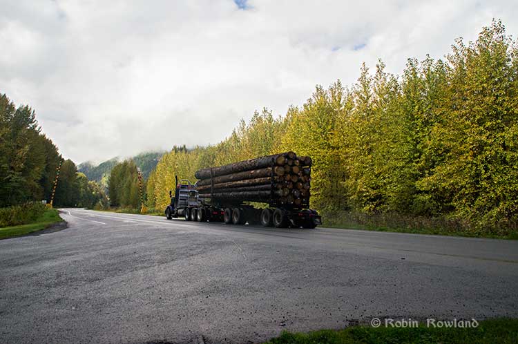
A logging truck passes the avalanche gates at Exstew on Highway 16, Sept. 29, 2014.  (Robin Rowland)
A logging truck passes the avalanche gates at Exstew on Highway 16, Sept. 29, 2014. (Robin Rowland)

The swing gates are avalanche gates and, in the winter, Highway 16 can be shut down if an avalanche closes the highway or the danger from avalanche is too great to allow motorists to proceed. When you drive the highway from Terrace to Prince Rupert in the winter (the signs were covered up when I drove Monday) you are warned “Avalanche danger Next 13 kilometres. No stopping.”

The Exstew avalanche gates, (Robin Rowland/Northwest Coast Energy News)

The drive along the Skeena from just west of Exchamsiks River Provincial Park all the way to Tyee where the highway turns inland to reach northwest to Prince Rupert on Kaien Island is one of the most spectacular drives on this planet. The highway snakes along a narrow strip of land with steep mountain cliffs on one side and the vast river on the other.

The problem is that apart from locals and tourists, none of the “experts” whether journalist, think tanker, bureaucrat or politician have, apparently ever driven from Prince Rupert to Terrace.

When both Opposition Leader Tom Mulcair and Liberal Leader Justin Trudeau were in the northwest earlier this summer to “engage” with the local people, apart from short boat trips down Douglas Channel, they flew everywhere. Scheduling you know. Stephen Harper has never visited northwest BC and probably never intends to. His cabinet members fly in for photo ops and then are on the next plane out of town.

Of all the visiting journalists who have come to the northwest only a couple have bothered to drive around the region. Most fly-in fly-out. These days, most often budget-strapped reporters never leave their offices, interviewing the same usual suspects by phone on every story.

On Monday, I took most of the photographs on my way back from Prince Rupert to Terrace after my appointment, so the sequence is from west to east. There are also very few places along the river where you can safely stop. There are concrete barricades on both sides of the highway to prevent vehicles either going into the river or onto the narrow CN right-of-way.

There are, however, two rest stops and a number of small turnoffs on the highway, the turnoffs mainly intended for use by BC Highways, but which are also used by tourists, fishers and photographers.

aberdeencreek1

The first image was taken at one of those highway turnoffs just east of Aberdeen Creek. This is what the highway and rail corridor are like all along the Skeena, the highway, bounded by concrete barricades, the CN rail line and then the towering mountains. Note where the telegraph and telephone lines are—further up the cliffside.

aberdeencreek4

A closer view of the highway and rail corridor just east of Aberdeen Creek.

aberdeencreek3

Here is the view of the Skeena River from the Aberdeen Creek turnoff. You can see to the east, a mountain and the narrow strip of fill land that supports the highway and the rail line.


aberdeencreek2
You see the broad width of the mighty Skeena, the Misty River, as it is called by the Tsimshian First Nation and by everyone else who lives in the northwest and on the right side of the image, the highway and rail corridor built on fill.

Any room for a pipeline?

aberdeencreek5

There’s another turnoff on the other side of the headland east of Aberdeen Creek, looking back the way we came.

khyex1

The final small turnoff is just by the Kylex River. Again you can see how narrow the highway and rail corridor are.

basalt

A few kilometres further along—as I said the highway snakes and curves its way along the riverbank–  you come to the Basalt Creek rest area. So this telephoto image shows a logging truck heading west,   taken from Basalt Creek, looking back at the highway.

Again you can see both the highway and CN line are built on fill. Is there any room for a pipeline?

Any room for a 25 metre pipeline right-of-way?

Between Basalt Creek and Telegraph Point, a few kilometres to the east, again the highway and rail line hug the narrow strip between the river and mountains.

Rowland_CN_container_Skeena

This shot, taken from Telegraph Point, in October 2013, shows a CN intermodal container train heading to Prince Rupert. The container trains and the coal trains usually have between 150 and 180 cars. If a winter avalanche took out a train, there would be environmental damage, but that damage would be insignificant from coal or containers compared to a train of railbit tankers carrying diluted bitumen.

At Telegraph Point, the second of the three rest stops between Prince Rupert and Terrace, again there is just a narrow strip between the mountain, the highway and the river.

telegraph1

telegraph2

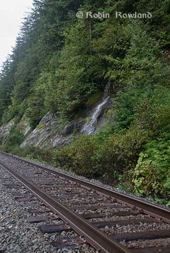
Across the highway from the rest stop, you can again see the narrow corridor, the first shot looking west the rail line close to the cliff face, the second, east, with the waterfall, which you don’t see during the rest of the year, fed by the fall monsoon.


telegraphmarch2013Two shots from the same location, Telegraph Point, taken in March, 2013, of a CN locomotive hauling empty coal cars back to the fields around Tumbler Ridge. (No waterfall in March)

telegraphmarch2013_1


Alternative routes

Everyone has assumed that if Northern Gateway changed its route, the most likely choice given the configuration of the pipeline at the moment is to follow the Skeena.

There are alternatives. The Petronas LNG project and its partner TransCanada Pipelines have proposed a more northern cross-country route, which would go north from the Hazeltons, avoiding the Skeena 

Proposed natural gas pipeline. (TransCanada)

The BG Group and Spectra Energy are also contemplating a pipeline…although details on the website are rather sparse.

If Enbridge wanted to try a northern route, similar to the one TransCanada contemplates for Petronas, Northern Gateway would again run into trouble.

It would require reopening or creating a new Joint Review Panel, many more years of environmental and social impact studies of the route, even under Stephen Harper’s fast track system. The TransCanada/Petronas pipeline would also cross the traditional territory of the Gitxsan First Nation and if Enbridge tried that the company would have to deal with the fact that it signed a controversial agreement with Elmer Derrick that was immediately repudiated by most members of the Gitxsan First Nation and eventually dropped by Enbridge.

So why does this idea of a pipeline to Prince Rupert keep coming up?

In most cases, the idea of the pipeline to Prince Rupert is always proposed by Albertans, not from any credible source in British Columbia, or the suggestions come from desk bound analysts in Toronto and Ottawa both in think tanks and in the newsrooms of dying newspapers who have never seen the Skeena River apart from a tiny handful who have looked at Google Street View

(Yes you can Google Street View Highway 16 along the Skeena, I recommend it if you can’t do the drive)

Perhaps the worst example of this failure of both analysis and journalism came in the Edmonton Journal on July 7,2014, when it published a piece by Bob Russell, entitled Opinion: Make Prince Rupert the terminus, which went over the same old inaccurate arguments.

The overland route currently proposed by Enbridge is fraught with environmental issues because it goes over coastal mountains and streams before entering Kitimat’s port. This port will also be the base of perhaps as many as four liquefied natural gas terminals, which will result in the channel always busy with LNG ships outbound and returning from many Asian ports.

There are existing rights of way for the major highway, the Yellowhead, and CN Rail line from Edmonton to the Port of Prince Rupert, so this eliminates the issue of transgressing First Nations lands. The technical issues of narrow passages can be overcome with engineering. In fact, the pipeline can be buried in the roadway at some restricted locations if absolutely necessary, but two different engineers have assured me that for the most part, the right of way should be able to handle the pipeline. A vital factor, of course, is to reduce the impact by eliminating the need for two pipelines.

The clue is how the Edmonton Journal describes Russell;

Bob Russell has an extensive background in planning and was a member of the Edmonton Metro Regional Planning Commission. He has flown the Douglas Channel, visited Kitimat and toured the Port of Prince Rupert.

This is so typical of the Albertan attitude toward northwest British Columbia,  people fly in for a couple of days, make a quick observation, and fly out again and present themselves as experts on the region. (Some “experts” on Kitimat, very active on Twitter have apparently never left Calgary).

It obvious that the “two engineers” who assured him “the right-of-way could handle of pipeline” have no idea what they’re talking about. As the photos show there is barely enough room for a highway and a rail line much less a 25 metre wide pipeline corridor.

If the pipeline was to be built as Russell proposed, the only highway between Prince Rupert and the rest of Canada would have to be closed for years, there are no detours.  All so a pipeline can be buried under the asphalt not in solid ground, but in the fill on the side of a riverbank in an avalanche zone?

Of course, closing a highway up here won’t inconvenience anyone in Edmonton or Calgary, will it?

Would CN be happy with years of disruption of their lucrative traffic to Prince Rupert with grain and coal outbound to Asia and all those containers coming in to feed Chinese products to the North American market? (you can be sure Walmart wouldn’t be happy about that, not to mention prairie farmers including those from Alberta)

Russell’s statement

There are existing rights of way for the major highway, the Yellowhead, and CN Rail line from Edmonton to the Port of Prince Rupert, so this eliminates the issue of transgressing First Nations lands.

Is also inaccurate.

I was told by First Nations leaders during the Idle No More demonstrations in the winter of 2013, that, a century ago, when the Grand Trunk built the railway along the Skeena , they did just that, built it without consulting the First Nations along the route, sometime digging up native cemeteries and sacred spots.

While apparently CN has worked in recent years to improve relations with the First Nations along the rail line, according to those leaders some issues of right-of-way remain to be resolved.

If there were any plans to build a diluted bitumen pipeline along that route, that would likely mean another court battle adding to those already before the Federal Court, a court battle that would cost Enbridge, CN, the federal government, environmental NGOs and the First Nations more millions in lawyers’ fees.

It’s doubtful if in the long gone (and perhaps mythical) days of “get it right” journalism that the Russell opinion piece would have passed the scrutiny of an old fashioned copy editor and fact checker.

In 2012, the Edmonton Journal (in a story no longer available on their website) also cited former Alberta Premier Peter Lougheed and former Bank of Canada governor David Dodge, as also favouring Prince Rupert.

Dodge, who was in Edmonton Tuesday to deliver a speech on the global economic outlook at MacEwan University, said Enbridge’s proposed Northern Gateway pipeline to Kitimat looks like even more of a long shot.
“I think the project to Kitimat looks, objectively, more risky. So why hasn’t much greater effort gone into looking at Prince Rupert and taking (bitumen) out that way? My guess is, the easiest place to get B.C. to buy into the project would be to go to Rupert.”
Dodge’s views echo those of former Alberta Premier Peter Lougheed, who also favours looking at an alternate pipeline route to Prince Rupert, where ocean-going supertankers can navigate more easily.

Back in 2012, I finished my piece for the Huffington Post by saying:

So why do people insist, despite the evidence, that the Northern Gateway go to Prince Rupert? It’s no longer an pipeline; it’s emotion and ideology. Ideology in that opposition to the Northern Gateway is seen by conservatives as heretical opposition to free enterprise itself. Emotion among those who see promoting the oil patch as an issue of “Alberta pride” and even Canadian patriotism.
For the promoters of the pipeline to Prince Rupert, ignoring the science of geology and the study of geography across all of northwestern B.C. is no different than repeatedly knocking your head against the Paleozoic metamorphic greenstone of the mountain cliffs along the Skeena. It only gives you a headache.

Things haven’t gotten much better in the past two years. In fact they’re getting worse as opposition to pipelines mounts.

It seems that in 2014  the Alberta and the federal government policy in promoting pipelines Northern Gateway, KinderMorgan’s TransMountain, Keystone XL, Line 9 Reversal and Energy East (slick PR and smiling representatives at open houses, politicians at strictly controlled photo ops) is to ignore facts on the ground and to refuse to deal with the concerns of local people from coast to coast.

There could, perhaps, be a more inclusive and truly science-based pipeline planning process that could see pipelines go on optimum routes but that isn’t happening.

The policy  for the oil patch and its politician supporters when it comes to pipelines is facts and geology don’t really matter. So they put on ruby slippers, knock their heels together three times and send pipelines down a yellow brick road to an Emerald City (while telling the locals to ignore the man behind the curtain)

Related links

The Save Our Salmon website has a different view, arguing that federal government and the energy companies have a plan to create an energy corridor for bitumen pipelines to Prince Rupert.

Kitimat air shed study raises more questions than it actually answers

The sudden release early Friday, July 18, by the British Columbia Ministry of the Environment about the Kitimat Valley air shed study brings more questions than the answers it provides; some questions are political, some technical.

The questions include

1. Why was the study suddenly released after the province said it was “privileged?”
2. Did the apparently rushed release mean that the study, as far as the public is concerned, is incomplete?
3. While most people in Kitimat believed that the study would be a wide ranging look at all parameters of industrial development in the valley, it was limited to just two factors, sulphur dioxide and nitrogen dioxide.
4. It appears that everyone involved were consulted prior to the release with one key execption, the District of Kitimat. Why?
5. The study appears to have changed in its criterion from the time of the request for proposal and the final release one issue—an oil export terminal, which went from “crude” in the request for proposal  to refined in the final report.

Douglas Channel
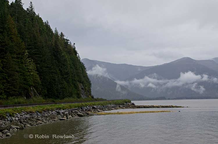
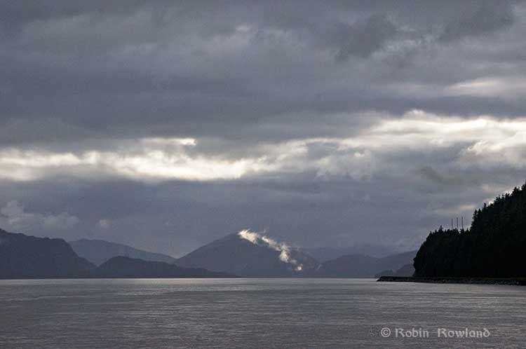
Clouds over Douglas Channel. (Robin Rowland/Northwest Coast Energy News)`

While the study is spun has a showing that industrial development in the Kitimat Valley can proceed as long as the environment is properly managed, the gaps and the spin will likely bring doubt to the results. That means that a wider ranging and truly independent study of the air shed is needed so that both residents and industry can then make the proper decisions.

Ironically, a proper study may actually come from industry, rather than government since LNG Canada has said that a full air shed study will be part of its environmental assessment filing expected in the fall.

The air shed proposal

In October  2013, the Ministry of the Environment issues a “request for proposal” to “study potential cumulative effects to environment and human health from existing and proposed industrial facilities in the Kitimat airshed.” to be filed by March 31, 2014.

According to the government website,

The Province will fund a $650,000 scientific study to help inform regulatory and policy development for future industrial activity in the Kitimat area. The goal is to ensure the potential impacts from industrial air emissions are clearly understood prior to new projects being approved and in operation.
The Kitimat Airshed Impact Assessment Project will look at the cumulative effects of existing and proposed industrial air emissions in the airshed. These include emissions from: an existing aluminium smelter, three proposed LNG terminals, a proposed oil refinery, a crude-oil export facility, and gas-turbine-powered electrical generation facilities. The study will focus on sulphur dioxide and nitrogen dioxide emissions from these facilities.
The study will assess the impact of emissions through a number of scenarios, including their potential effects on water and soil, as well as on vegetation and human health from direct exposure.

With that news release, it appears that many people assumed that “cumulative effects of existing and proposed industrial air emissions in the air shed,” would include all possible scenarios and contaminants.

The report, when it was released on Friday, covered just  the “focus” sulphur dioxide and nitrogen dioxide and no other factors in air quality.

Crude or refined oil export?

airshedmap3As Northwest Coast Energy News noted that the report, as released, doesn’t include any references to the Enbridge Northern Gateway project, even though Northern Gateway is a source of “proposed industrial air emissions in the air shed.” The request for proposal also mentions “a crude-oil export facility” but the report as issued concerns a marine terminal for Black’s refinery

David Black’s Kitimat Clean website says 

The products will be exported via a marine terminal on the Douglas Channel. Projected volumes include 320,000 barrels per day of diesel fuel, 110,000 barrels per day of gasoline and 60,000 barrels per day of jet fuel.

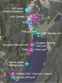
The map in the main report clearly shows that the study concerned the “Kitimat Clean Refinery Port” not a crude oil export facility—in other words likely Enbridge Northern Gateway.

Kitimat excluded

On October 21, 2013,  District of Kitimat Council endorsed a motion by former Councillor Corinne Scott:

“The BC Government has recently announced a budget of $650,000 to study the cumulative effects on the air quality due to the proposed industrial development in the District of Kitimat. It would be beneficial to have a representative from the District of Kitimat as an active participant on the committee to provide input and feedback as the study progresses.”

At the time Chief Adminstrative Officer Ron Poole told council that the minister’s office had called and promised to “involve the District.”

At that meeting, Councillor Mary Murphy reported that member were “vocal” at the Union of BC Municpalities that it was essential that Kitimat be involved. Councillors suggested that the study be wide ranging and include emissions already in the area and residual emissions left over from the closed Eurocan and Methaex operations.

The provincial final air shed report makes no mention at all of the District of Kitimat, Eurocan or Methanex.

In April, 2014, after the March 31, reporting deadine, the District and Council had heard nothing from the province. So in April, District Council passed a motion asking for a report on the status of the study.

Crown Privilege

In June, the province refused to release the report to lawyers involved in a suit against the Environmental Assessment Board which is challenging Rio Tinto Alcans’ permit to increase sulphur dixoide emission in the valley. According to the Globe and Mail,  Dennis Doyle, a lawyer with the Ministry of the Attorney General, in the RTA suit, wrote to the Environmental Law Centre in Victoria

In a follow-up letter dated June 12, Mr. Doyle said, “On the matter of the Kitimat Airshed Study I am instructed that this report was prepared to guide development of government policy on industrial development in the Kitimat area and to assist the executive council in its ongoing deliberations. It is not a report that was prepared for the Respondent and played no part of the decision-making process for the permit amendment which is now under appeal.”

In mid-July, the lawyers then asked the Environment Assessment Board to either turn over the air shed report or explain why it was covered by Crown Privilege.

The EAB told the province to respond to that question by July 18. Instead there was a hastily called news conference and the report was released. However, a close look at the report shows that it was likely rushed to meet the EAB deadine and was incomplete—rather surprising for a report that was supposed to be complete by March 31.

Rushed report

airshedcoverWhat evidence is there that the report was rushed out by the Ministry of the Environment? The most compelling indication is that instead of a public-friendly Summary Report with an executive summary and clear conclusions, there was nothing more than a short Power Point presentation.

Most people in Kitimat who follow the energy debate are familiar with the approach of combining a readable summary with technical data. It is most evident in the report of the Enbridge Northern Gateway Joint Review, which issued a relative short summary, Connections along with the long technical report, Considerations.

Let’s take as a prime example, the original report on the Kitimat airshed commissioned by Rio Tinto Alcan. In that case, ESSA Technologies Ltd of Vancouver, the company hired by the RTA Kitimat Modernization Project to study the effects of increased sulphur dioxide emissions in the Kitimat Valley, issued three documents, an easy to understand 37-page summary report, a much longer 456 page Technical Assessment Report and a third  332 page volume of appendices, technical data and tables.

It was the same company, ESSA Technologies, that was retained by the province to do the much larger study of the airshed. However, the only public-friendly information was the 16 page highly simplified Power Point presentation.

The ESSA summary report for RTA shows in plain language, the reasons for its conclusions that the increased sulphur dioxide from KMP on human health “is characterized as moderate, an acceptable impact, but in need of closer scrutiny with moderate monitoring.” That report also outlines the limitations and uncertainties of the study.

There was no similar plain language summary released for the overall provincial air shed study, even though it was produced by the same company and came to similar conclusions.  To find any limitations or uncertainties in the provincial air shed study you have to do a computer search for those key words.

So it is apparent that intended audience for the report is not really  those who live in Kitimat, where over the past five years there is wide knowledge that a summary release along with a technical report is considered a standard procedure.

Kitimat not consulted

At the Friday news conference, reporters asked Environment Minister Mary Polak several times about the delay in releasing the report, and then why it was suddenly released.

In answer to the initial question, Polak said, “We had always intended to release it.” She refused to comment on the claim of cabinet privilege, saying that was the responsibility of government lawyers at the Ministry of the Attorney General. She said that the government had received the March 31 report “by the end of April and “it went through quite a rigorous and thorough review by different agencies… we are satisfied now that the findings have been given the kind of rigorous overview and we’re pleased with what has resulted from that.”

Polak said the Haisla Nation were consulted before the commissioning of the report.

Asked again about who the BC government consulted during the review period, she replied, “There were a number of other groups involved in technical review, so not just Ministry of Environment, you’ll be aware of Northern Health authority, but Ministry of Natural Gas Development, Health Canada, Environment Canada and also specialist reviewers from the Province of Quebec, the University of Helsinki, UBC, also private consultants. Then we spent some time going over and having a technical review with Gitga’at and Coastal Coastal First Nations. So it was a matter of ensuring that we had done the very best review of the work before the occasion on which we released it.”

Which leaves one big question, why was the Province of Quebec and the University of Helsinki consulted and Kitimat, despite requests, was not?

Not in the report, not my department

The provincial government called for a report on the “cumulative effects of existing and proposed industrial air emissions” and noted it would focus “ focus on sulphur dioxide and nitrogen dioxide emissions from these facilities.” It is clear that the report did not go beyond the narrow focus on those two substances.

At the Vancouver news conference, a reporter  asked Polak why green house gases were not included.

She replied, “That’s not what this study was intended to look at. This department deals with pollutants and pollution and protecting our environment from it, whereas GHG [green house gas] emissions are dealt with in our department around climate change and climate action. These particular substances have an immediate impact on human health and vegetative health and the receiving environment generally unlike GHGs which are a more global impacted and of course have an impact on climate change. This study only looked at those pollutants sulphur doixide and nitrogen dioxide

Then a second reporter asked here about particulate matter, to which Polak replied, “Coming from the Fraser Valley I am very aware of the impact of particulate matter. Any industrial development that we permit in British Columbia or receives an environmental assessment certificate, particulate matter and the release of particulate matter is one of the things that gets evaluated as we determine whether or not to grant those permits. Or to put stipulations on those permits in order to ensure a reduction or management of particulate matter. That’s where that’s dealt with and we have some pretty good understanding of how that operates. We also have some modelling from this study.

“The reason this study didn’t report on that because we hadn’t asked them to. We specifically wanted to get at the issue of sulphur disoxide and nitrogen dioxide but please do not take frm that because it’s not in the study, it doesn’t get looked at. It simply gets looked at in a different process. In this case it was the understanding of the Kitimat air shed with respect to sulphur dixoide and nitrogen dioxide that we needed to have a better answers and better information.”

In other words, despite what the original proposal said: “The goal is to ensure the potential impacts from industrial air emissions are clearly understood prior to new projects being approved and in operation,” the provincial government is content to wait until the permit phase to consider particulate matter, rather than include particulate matter in the long term planning for the air shed.

And for green house gases, the same attitude seems to apply, either it’s not her department or it will be dealt with sometime in the future.

What’s going on in the air shed?

Although the provincial government has been able to spin that the air shed report clears the way for more industrial development in the region, the report isn’t much help for long term planning for those both for and against industrial development in the valley.

First one has to wonder just how comprehensive was the study, even when it comes to sulphur dioxide and nitrogen dioxide?

The report for Rio Tinto Alcan for just one substance—sulphur dixoide—from one industry—aluminum smelting–led to a 456 page technical report with 332 pages of appendices.

The provincial technical report adds  one more substance, nitrogen dioxide,  and adds four LNG facilities, an oil refinery, different export terminals for those industries, and two hydro generating stations plus related shipping, including a passing mention of vehicular and train traffic. The new report  is 363 pages, including the appendices. (It should be noted that the air shed report does reference some of the information in the RTA report)

The various studies for the Enbridge Northern Gateway, which often contained material on air emissions, included a much longer list of what in industry jargon are called CPOC “chemicals of potential concern,” including chemicals that might be released in trace amounts from the Northern Gateway terminal, but may be of more concern from LNG projects. Who knows unless those substances are studied?

As was required by the Joint Review Panel, Enbridge also studied potential problems from accidental release of air-borne contaminants from the Northern Gateway project. There is no mention of accidental release in the current air shed study.

Although the increase in truck traffic in Kitimat is clearly visible to people who live in the town, the air shed report also speculates that with LNG and a possible refinery, there will also be a significant increase in rail traffic coming into Kitimat, hauled, of course, by diesel locomotives, which the report says is “expected to be conservatively captured within the background concentration adjustment.”

Can the Valley “handle industrial expansion”

Stakeholders in the region from the District of Kitimat to the Gitga’at First Nation to various environmental groups asked for a comprehensive review of what is going to happen in the Kitimat air shed with industrial expansion.

So the answer to the question can the valley “handle industrial expansion” after the flawed and limited report from the provincial government is not “yes,” but “we don’t know yet.”

It appears that the report is part of Christy Clark’s ongoing campaign that LNG will save the provincial economy.

There are two factors the report ignores.

First the energy companies are going to make their final investment decision on cold hard facts, including their own assessment of the potential problems from the air shed, not spin from the provincial government.

Second, until there is a proper air shed study, the First Nations, including the Haisla in Kitimat, the Gitga’at at Hartley Bay, the Kitselas in Terrace  will not have solid evidence to make a decision on the details of the LNG or refinery development on their traditional territory and increased ship traffic along the coast and that will come into immediate conflict with the Supreme Court ruling on the Tsilhqot’in decision and the finding that “Whether a particular use is irreconcilable with the ability of succeeding generations to benefit from the land will be a matter to be determined when the issue arises.”

There is a new Orwellian phrase used by both the federal and provincial government. Every report is “independent” and “science-based,” although all they all tend to support the policy of the commissioning agency.

What the Kitimat Valley, Douglas Channel and the Terrace region need is a truly independent and truly science based and truly comprehensive evaluation of the air shed. At the moment, that doesn’t exist. It should whether it comes from industry or if the local governments can find the budget to fund a proper study or some combination of the two.

Links

Kitimat Airshed Assessment
RTA report Sulphur-dioxide-technical-assessment.html

(Scanned version of copy in Kitimat public library)


Related

Business in Vancouver

Kitimat airshed modelling has narrow focus

Vancouver Observer

Province’s air pollution study green lights LNG build-up, but ignores climate change

News release: Andrew Weaver MLA
New airshed study is a “nail in the coffin” for government LNG dreams in Kitimat

Kitmat Votes: What the Joint Review Panel said about the Exxon Valdez disaster

Excerpts from the Northern Gateway Joint Review Panel report relating to the Exxon Valdez disaster.

Northern Gateway told the Joint Reivew Panel that

on a worldwide basis, all data sets show a steady reduction in the number
and size of oil spills since the 1970s. This decline has been even more apparent since regulatory changes in 1990 following the Exxon Valdez oil spill, which required a phase-in of double-hulled tankers in the international fleet. No double-hulled tanker has sunk since 1990. There have been five incidents of double-hulled tankers that have had a collision or grounding that penetrated the cargo tanks. Resulting spills ranged from 700 to 2500 tonnes

The Haisla countered by saying:

The Haisla Nation said that, although there have been no major spills since the Exxon Valdez spill in Prince William Sound, there were 111 reported incidents involving tanker traffic in Prince William Sound between 1997 and 2007. The three most common types of incidents were equipment malfunctions, problems with propulsion, steering, or engine function, and very small spills from tankers at berth at the marine terminal. The Haisla Nation said that, in the absence of state-of-the-art
prevention systems in Prince William Sound, any one of those incidents could have resulted in major vessel casualties or oil spills.

There were disputes about how the Exxon Valdez affected species in the Prince William  Sound area:

Northern Gateway said that, although crabs are known to be sensitive to toxic effects, they have been shown to recover within 1 to 2 years following
a spill such as the Exxon Valdez incident. Northern Gateway said that Dungeness crab was a key indicator species in its assessment of spill effects.

Northern Gateway said that potential effects to razor clams are not as well studied. It said that sediment toxicity studies after the Exxon Valdez spill did not suggest significant effects on benthic invertebrates. Following the Exxon Valdez and
Selendang Ayu oil spills in Alaska, food safety closures for species such as mussels, urchins, and crabs were lifted within 1 to 2 years following the
spill.

In response to questioning from the Council of the Haida Nation regarding potential spill effects on herring, Northern Gateway said that herring were a key indicator species in its spill assessment.
Northern Gateway said that the Exxon Valdez spill did not appear to cause population-level effects on Prince William Sound herring.

As did throughout its report, the Joint Review Panel gave great weight to Northern Gateway’s evidence:


Northern Gateway said that potential effects of oil stranded on the shorelines and in the intertidal environment were assessed qualitatively with particular reference to the Exxon Valdez oil spill. It said that the entire intertidal zone along affected
shorelines would likely be oiled, coating rocks, rockweed, and sessile invertebrates. Some of the diluted bitumen could penetrate coarse-grained intertidal substrates, and could subsequently be remobilized by tides and waves. There were
relatively few shoreline areas with potential for long oil residency. Northern Gateway said that the stranded bitumen would not be uniformly distributed, and that heavy oiling would likely be limited to a small proportion of affected shoreline. Northern
Gateway said that, compared to the Exxon Valdez oil spill, the simulation suggested that more dilbit would be distributed along a shorter length of shoreline.

Northern Gateway said that, due to the relatively sheltered conditions in Wright Sound, and in the absence of cleanup, most of the stranded oil would be weathered or dispersed into the marine environment within 3 to 5 years. It said that,
while weathering and dispersal could represent an important secondary source of hydrocarbon contamination of offshore or subtidal sediments, the weathered hydrocarbons themselves would have lower toxicity than fresh dilbit.

Northern Gateway assessed potential effects on key marine receptors including marine water quality, subtidal sediment quality, intertidal sediment
quality, plankton, fish, and a number of bird and mammal species. The company said that acute effects from monocyclic aromatic hydrocarbons such as benzene, toluene, ethylbenzene, and xylene may briefly occur in some areas. Acute effects from polycyclic aromatic hydrocarbons were not likely due to their low water solubility.
Northern Gateway said that chronic adverse effects on the subtidal benthic community were not predicted. After a large spill, consumption advisories for pelagic, bottom-dwelling and anadromous fish, and invertebrates from open
water areas and subtidal sediments would probably be less than 1 year in duration. Northern Gateway said that consumption advisories for intertidal communities and associated invertebrates, such as mussels, could persist for 3 to 5 years or longer in
some sheltered areas.

But dilbit is different from heavy crude

In response to questions from the Haisla Nation and the United Fishermen and Allied
Workers Union, Fisheries and Oceans Canada said that, although it had a great deal of information on conventional oils, the results of research conducted on the biological effects of conventional oil products may not be true for dilbit or unconventional products. Fisheries and Oceans Canada said that it was not in a
position to quantify the magnitude and duration of impacts to marine resources

The United Fishermen and Allied Workers Union said that, because there are so many variables, each spill is a unique event, and some results will be unknowable. It said that a spill the size of the Exxon Valdez incident would affect the entire ecosystem
in the project area, and that recovery to pre-spill conditions would be unlikely to ever occur. It said that a spill the size of the Exxon Valdez oil spill would likely have similar effects in the project area because marine resources in the project area are
similar to those in Prince William Sound. It argued that the cold, sheltered, waters of the Confined Channel Assessment Area would likely experience reduced natural dispersion and biodegradation of oil, leading to heavier oiling and longer recovery
times than seen in Prince William Sound and elsewhere.

The United Fishermen and Allied Workers Union said that patches of buried oil from the Exxon Valdez oil have been found on sand and gravel beaches overlain by boulders and cobbles. It said that effects from a tanker spill associated with the
Enbridge Northern Gateway Project would likely be more severe than the Exxon Valdez oil spill due to the more persistent nature of dilbit and the lack of
natural cleaning action in the sheltered waters of the Confined Channel Assessment Area.

The Gitxaala Nation’s experts said that large historical spill events are not necessarily good indicators of what will happen in the future. They
argued that each spill has unique circumstances and there is still significant uncertainty about the effects of major spills.
The Gitxaala Nation concluded Northern Gateway had failed to adequately consider the potential consequences on ecological values of interest to the Gitxaala.

Gitga’at First Nation said that a spill of dilbit greater than 5,000 cubic metres would result in significant, adverse, long-term, lethal, and sublethal effects
to marine organisms, and that effects would be particularly long-lasting on intertidal species and habitats. It also said that effects from a tanker spill associated with the project would probably be more severe than the Exxon Valdez oil spill, due to
the more persistent nature of dilbit and the lack of natural cleaning action in the sheltered waters

The JRP told how Nothern Gateway looked at the scientific evidence:

The company used a case study approach and reviewed the scientific literature for environments similar to the project area. The review examined 48 spills, including the Exxon Valdez oil spill in 1989, and 155 valued ecosystem components from  cold temperate and sub-arctic regions. Northern Gateway said that the scientific evidence is clear that, although oil spills have adverse effects on biophysical and human environments, ecosystems and their components recover with time.

Pacific herring, killer whales, and pink salmon were species that were extensively studied following the Exxon Valdez spill and were discussed by numerous participants in the Panel’s process.

As referred to by the Haisla Nation, Pacific herring are listed as “not recovering” by the Exxon Valdez Oil Spill Trustee Council. The Trustee Council said that, despite numerous studies to understand the effects of oil on herring, the causes constraining population recovery are not well understood.

Northern Gateway said that scientific evidence indicates that a combination of factors, including disease, nutrition, predation, and poor recruitment
appear to have contributed to the continued suppression of herring populations in Prince William Sound.

Northern Gateway said that 20 years of research on herring suggests that the Exxon Valdez oil spill is likely to have initially had localized effects on herring eggs and larvae, without causing effects at the population level. Northern Gateway said
that, even after 20 years, the effects of the spill on herring remain uncertain. It said that there has also been convergence amongst researchers that herring declines in the spill area cannot be connected to the spill.

Northern Gateway said that herring stocks along the entire coast of British
Columbia have been in overall decline for  years and that herring were shown to recover within 1 to 2 years following the Nestucca barge spill.

A Gitxaala Nation expert noted the uncertainty in interpreting the decline of herring following the Exxon Valdez oil spill and said that the debate is not likely to ever be settled.

The Living Oceans Society said that the Exxon Valdez Oil Spill Trustee Council reported that some killer whale groups suffered long-term damage from initial exposure to the spill. Northern Gateway’s expert said the research leads him to
conclude that the actual effects on killer whales of the Exxon Valdez spill are unknowable due to numerous confounding factors. He said that the
Exxon Valdez Oil Spill Trustee Council has not definitively said that killer whale mortalities can be attributed to the spill. A Government of Canada
expert said that the weight of evidence suggests that the mortality of killer whales was most likely related to the spill.

Northern Gateway said that mass mortality of marine fish following a spill is rare. In response to questions from the Haisla Nation, Northern Gateway said that fish have the ability to metabolize potentially toxic substances such as polycyclic aromatic hydrocarbons. It said that international experience with oil spills has demonstrated that fin fishery closures tend to be very short in duration.
Northern Gateway said that food safety programs for fin fish conducted following the Exxon Valdez spill and the Selendang Ayu spill in Alaska indicated
that the finfish were not affected by the spill and that the fish were found, through food safety testing programs, to be safe to eat.

The Haisla Nation referred to the Exxon Valdez Oil Spill Trustee Council report that discussed the complexities and uncertainties in the recovery status of pink salmon. It said that, by 1999, pink salmon were listed as recovered and that the
report noted that continuing exposure of embryos to lingering oil is negligible and unlikely to limit populations.

Northern Gateway said that the longterm effect of the spill on pink salmon survival is
best demonstrated by the success of adult returns following the spill. Northern Gateway said that, in the month following the spill, when there was still
free oil throughout Prince William Sound, hundreds of millions of natural and hatchery pink salmon fry migrated through the area. It argued that these fish would arguably be at greatest risk from spill-related effects but that the adult returns 2 years later were one of the highest populations ever. Northern Gateway said that sockeye and pink salmon appear to have been unaffected by the Exxon Valdez spill
over the long term.

In response to questions from the Council of the Haida Nation and the United Fishermen and Allied Workers Union, Northern Gateway said that effects
on species such as seaweed, crabs, and clams have been shown to be relatively short-term, with these species typically recovering within 2 years or less
following a spill, depending on circumstances.

Northern Gateway said that, based on the Exxon Valdez spill, the level of hydrocarbons dissolved or suspended in the water column would be expected
to be substantially lower than those for which potential toxic effects on crabs or fish may occur.

In response to questions from BC Nature and Nature Canada, Northern Gateway said that the Exxon Valdez oil spill indicates which species of birds are most susceptible to oiling. Seabirds are generally vulnerable to oil spills because many species spend large amounts of time at sea. Diving seabirds such as murres are particularly vulnerable to oiling because they spend most of their time on the surface, where oil is found, and tend to raft  together. Thus, these species often account for most of the bird mortality associated with oil spills.

More than 30,000 seabird carcasses, of which 74 per cent were murres, were recovered following the Exxon Valdez spill and it was initially estimated
that between 100,000 and 300,000 seabirds were killed. However, detailed surveys of breeding murres in 1991 indicated no overall difference from pre-spill levels confirming rapid recovery of this species.

Northern Gateway said that, although potential toxicological effects from oil spills on
birds have been well documented in laboratory studies, the ultimate measure of recovery potential is how quickly birds return to their natural abundance and reproductive performance. It said that recovery is often difficult to measure due to
significant natural variation in populations and the fact that the baseline is often disputed. It said that this can lead to misinterpretation of results depicting recovery.

At the request of Environment Canada, Northern Gateway filed two reports on the susceptibility of marine birds to oil and the acute and chronic effects of the Exxon Valdez oil spill on marine birds. Northern Gateway said that marine birds are
vulnerable to oil in several ways such as contact, direct or indirect ingestion, and loss of habitat.
It said that many marine bird populations appear to have recovered from the effects of the Exxon Valdez spill, but some species such as harlequin ducks and pigeon guillemots have not recovered, according to the Exxon Valdez Oil Spill Trustee
Council. It said these reports demonstrate that marine birds are susceptible to marine oil spills to varying degrees depending on the species, its life
history and habitat, and circumstances associated with the spill.
Northern Gateway concluded that:
• Marine, freshwater, and terrestrial environments recover from oil spills, with recovery time influenced by the environment, the valued ecosystem components of interest, and other factors such as spill volume and characteristics
of the oil. Depending on the species and circumstances, recovery can be quite rapid or it can range from 2 to 20 years. Other scientific reviews have indicated that recovery of marine environments from oil spills takes 2 to 10 years.
• Different marine ecosystem components recover at different rates. Recovery time can range from days or weeks in the case of water quality, to years or decades for sheltered, soft sediment marshes. Headlands and exposed rocky shores can take 1 to 4 years to recover.
• Little to no oil remained on the shoreline after 3 years for the vast majority of shoreline oiled following the Exxon Valdez spill,
• The Exxon Valdez Oil Spill Trustee Council concluded that, after 20 years, any remaining Exxon Valdez oil in subtidal sediment is no longer a concern, and that subtidal communities are very likely to have recovered.
• Because sheltered habitats have long recovery times, modern spill response gives high priority to preventing oil from entering marshes and other protected shoreline areas.
• Valued ecosystem components with short life spans can recover relatively rapidly, within days to a few years. Recovery is faster when there is an abundant supply of propagules close to the affected area. For example, drifting larvae from
un-oiled marine and freshwater habitats will rapidly repopulate nearby areas affected by a spill.
• Plankton recovery is typically very rapid.
• Seabed organisms such as filter feeders may be subject to acute effects for several years, depending on location, environmental conditions, and degree of oiling.
• Marine fisheries and other human harvesting activities appear to recover within about 2 to 5 years if the resource has recovered and has not been affected by factors other than the oil spill.
• Protracted litigation may delay resumption of fisheries and other harvesting.
• Local community involvement in spill response priorities and mitigation plans can reduce community impacts and speed recovery of
fisheries and harvesting activities.
• A long life span typically means a long recovery time, in the case of bird and mammal populations that can only recover by local reproduction rather
than by immigration from other areas.
• Fast moving rivers and streams tend to recover more quickly than slow flowing watercourses, due to dispersal of oil into the water column by turbulence, which can enhance dissolution, evaporation, and microbial degradation.
• Drinking water and other water uses can be affected by an oil spill for weeks to months. Drinking water advisories are usually issued. Groundwater use may be restricted for periods ranging from a few weeks to 2 years, depending on
the type of use.

• Groundwater can take years to decades to recover if oil reaches it. Groundwater does not appear to have been affected in the case of Enbridge’s Kalamazoo River spill, near Marshall, Michigan.

• Freshwater invertebrates appear to have recovered within 2 years in several cases.
• Freshwater fisheries may recover fully in as little as four years, with signs of partial recovery evident after only a few months. The ban on consumption of fish in the Kalamazoo River was to be lifted approximately two years following
the spill.
• Human activities are affected by factors such as cleanup activities, safety closures and harvesting bans. These typically persist for months to a few years.
• Appropriate cleanup can promote recovery, while inappropriate cleanup techniques can actually increase biophysical recovery time.
Modern spill response procedures carefully consider the most appropriate treatment for the oil type, level of contamination, and habitat type.
The Living Oceans Society noted the following in relation to potential recovery of the marine environment following a spill:
• Physical contamination and smothering are primary mechanisms that adversely affect marine life, particularly intertidal organisms.
• Birds and mammals suffer the greatest acute impact when exposed to oil at or near the water surface.
• Marine communities have variable resiliency to oil spills, from highly tolerant (plankton, kelp beds), to very intolerant (estuaries and sea otters). Impacts to communities and populations are very difficult to measure due
to lack of scientific methods to measure long term,sublethal, and chronic ecological impacts.
• As the return of the marine environment to the precise conditions that preceded the oil spill is unlikely, a measurement of spill recovery can be
based on a comparison of un-oiled sites with oiled sites of similar ecological characteristics.
• The Exxon Valdez oil spill killed many birds and sea otters. Population-level impacts to salmon, sea otters, harbour seals, and sea birds appear to have been low. Wildlife populations had recovered within their natural range of variability after 12 years.
• Intertidal habitats of Prince William Sound have shown surprisingly good recovery. Many shorelines that were heavily oiled and then cleaned appear much as they did before the spill. There is still residual buried oil on some beaches. Some mussel and clam beds have not fully recovered.
• The marine environment recovered with little intervention beyond initial cleaning. Natural flushing by waves and storms can be more effective than human intervention.
• Wildlife rescue and rehabilitation efforts had a marginal beneficial effect on the recovery of bird and mammal populations
• The impacted area of Prince William Sound had shown surprising resiliency and an ability to return to its natural state within the range of natural variability.
• The Exxon Valdez oil spill had significant and long-lasting effects on people and communities.

Questioning experts

The Panel posed a series of questions to experts representing Northern Gateway, federal government participants, and the Gitxaala First Nation regarding the potential recovery of marine ecosystems following a large oil spill.
Northern Gateway said that past marine spills have demonstrated that, over time, the environment will recover to a pre-spill state, and that most species fully recover. It said that species associated with the surface of the water tend to be most susceptible to oil spills, and that cleanup efforts can help direct and
accelerate natural restoration processes.
Federal government experts generally agreed with Northern Gateway’s responses, although they stressed that effects could be felt in areas other than the water surface, such as intertidal and subtidal zones. They said that it is difficult to define
and assess effects and recovery, depending on the species and availability of baseline information.
They said that most species may fully recover over time, and that the time frame for this recovery can be extremely variable depending on species and circumstances.
The Gitxaala Nation’s experts noted the potential for effects on species at the water surface and in intertidal areas, and noted exceptions to the notion that
the marine environment will naturally restore itself.
They said that full recovery can occur, depending on the circumstances, but is not guaranteed. They said that it is difficult to assess spill effects in the absence
of adequate baseline information.


Despite the quarter century of studies on the Exxon Valdez inicident, the paucity of studies prior to the spill mean that arguments will continue over “baseline information.”

Participants told the Panel that a lack of baseline information has often made it difficult to separate spill-related effects from those that were caused by natural variation or other causes not related to a spill.

Northern Gateway acknowledged the need for adequate baseline information. Parties such as Coastal First Nations, Raincoast Conservation Foundation, and the Gitxaala Nation said that Northern Gateway had provided insufficient baseline information to assess future spill-related effects. The Kitsumkalum First Nation asked how
spill-related effects on traditionally harvested foods could be assessed in the absence of baseline information.

The Haisla Nation noted the importance of collecting baseline data in the Kitimat River valley to compare with construction and spill-related impacts. The Haisla Nation submitted a report outlining important considerations for a baseline
monitoring program. One recommendation was that the program should engage stakeholders and be proponent-funded. In response to questions
from Northern Gateway, the Haisla Nation noted that a design along the lines of a before/after control/impact model would be appropriate.

In response to these comments, Northern Gateway noted its commitment to implement a Pipeline Environmental Effects Monitoring Program. Northern Gateway’s
proposed framework for the monitoring program indicates that a number of water column, sediment, and biological indicators would be monitored.
The Raincoast Conservation Foundation said that one of the principal lessons learned from the Exxon Valdez oil spill was the importance of collecting abundance and distribution data for non-commercial species. Because baseline information was
lacking, spill effects on coastal wildlife were difficult to determine. Environment Canada also noted the importance of adequate baseline information to
assess, for example, spill-related effects on marine birds.

Northern Gateway outlined the baseline measurements that it had already conducted as part of its environmental assessment. It also said that is
would implement a Marine Environmental Effects Monitoring Program. Northern Gateway said that the initial baseline data, plus ongoing monitoring,
would create a good baseline for environmental quality and the abundance, distribution, and diversity of marine biota. In the event of an oil spill
it would also help inform decisions about restoration endpoints.

Northern Gateway said that it would provide Aboriginal groups with the opportunity to undertake baseline harvesting studies. In response to questions from the United Fishermen and Allied Workers Union, Northern Gateway said that baseline information gathered through the environmental effects monitoring program would also be relevant to commercial harvest management and for assessing compensation claims in the event of a spill.
The Kitimat Valley Naturalists noted the ecological importance of the Kitimat River estuary.

The Joint Review Panel, in its conclusions and ruling, generally agreed with the energy industry that affects of a major oil spill would be temporary.

The Panel heard evidence and opinion regarding the value that the public and Aboriginal groups place on a healthy natural environment.

The Panel finds that it is not able to quantify how a spill could affect people’s values and perceptions.
The Panel finds that any large spill would have short-term negative effects on people’s values, perceptions and sense of wellbeing.

The Panel is of the view that implementation of appropriate mitigation and compensation following a spill would lessen these effects over time. The
Panel heard that protracted litigation can delay recovery of the human environment.

The Panel heard that appropriate engagement of communities in determining spill response priorities and developing community mitigation plans can also lessen effects on communities. Northern Gateway has committed to the development
of Community Response Plans
The Panel’s finding regarding ecosystem recovery following a large spill is based on extensive scientific evidence filed by many parties, including information on recovery of the environment from large past spill events such as the Exxon Valdez
oil spill. The Panel notes that different parties sometimes referred to the same studies on environmental recovery after oil spills, and drew different conclusions. In its consideration of natural recovery of the environment, the Panel focused
on effects that are more readily measurable such as population level impacts, harvest levels, or established environmental quality criteria such as
water and sediment quality criteria.
The Panel finds that the evidence indicates that ecosystems will recover over time after a spill and that the post-spill ecosystem will share functional attributes of the pre-spill one. Postspill ecosystems may not be identical to pre-spill ecosystems. Certain ecosystem components may continue to show effects, and residual oil
may remain in some locations. In certain unlikely circumstances, the Panel finds that a localized population or species could potentially be permanently affected by an oil spill. Scientific studies after the Exxon Valdez spill indicated that the vast majority of species recovered following the spill and that functioning ecosystems, similar
to those existing pre-spill, were established.
Species for which recovery is not fully apparent, such as Pacific herring, killer whales, and pigeon guillemots, appear to have been affected by other
environmental factors or human influences not associated with the oil spill. Insufficient pre-spill baseline data on these species contributed to
difficulties in determining the extent of spill effects.
Based on the evidence, the Panel finds that natural recovery of the aquatic environment after an oil spill is likely to be the primary recovery
mechanism, particularly for marine spills. Both freshwater and marine ecosystem recovery is further mitigated where cleanup is possible, effective, and beneficial to the environment.
Natural processes that degrade oil would begin immediately following a spill. Although residual oil could remain buried in sediments for years, the Panel finds that toxicity associated with that oil would decline over time and would not cause
widespread, long-term impacts.

The Panel finds that Northern Gateway’s commitment to use human interventions,
including available spill response technologies, would mitigate spill impacts to ecosystems and assist in species recovery. Many parties expressed concerns about potential short-term and long-term spill effects on resources that they use or depend on, such as drinking water, clams, herring, seaweed, and fish. The weight of
evidence indicates that these resources recover relatively rapidly following a large oil spill.

For example, following the Selendang Ayu and Exxon Valdez spills in Alaska, fin fish were found, through food safety testing programs, to be safe to eat. Food safety closures for species such as mussels, urchins, and crabs were lifted within 1 to
2 years following the spills.
The actual time frame for recovery would depend on the circumstances of the spill. Until harvestable resources recover, various measures are typically put in place, such as compensation,harvest restrictions or closures, and provision of
alternative supply.
It is difficult to define recovery of the human environment because people’s perceptions and values are involved. This was made clear to the
Panel through oral statements and oral evidence.
The Panel finds that oil spills would cause disruptions in people’s lives, especially those people who depend on the marine environment for sustenance, commercial activities and other uses. The extent and magnitude of this disruption
would depend on the specific circumstances associated with the spill. The Panel views recovery of the socio-economic environment as the time when immediate impacts and interruption to people’s lives are no longer evident, and the
natural resources upon which people depend are available for use and consumption.
The Panel heard that assessing the potential recovery time of the environment is often complicated by challenges in separating background or unrelated events from spill-related effects. There can be natural variation in species populations,
and other natural and human-induced effects can also make it difficult to determine which impacts are spill-related and which are not.
The Panel notes that Northern Gateway has committed to collect baseline data and gather baseline information on harvest levels and values through initiatives such as its Environmental Effects Monitoring Program, Fisheries Liaison
Committee, and traditional harvest studies. The Panel finds that these commitments go beyond regulatory requirements and are necessary. This information would contribute to assessments of spill effects on resource harvesting values,
post-spill environmental recovery, and loss and liability determinations.
The Panel is of the view that it is not possible to predict a specific time in which overall recovery of the environment may occur. The time for recovery would depend on the type and volume of product spilled, environmental conditions,
the success of oil spill response and cleanup measures, and the extent of exposure of living and non-living components of the environment to the product spilled. Recovery of living and non-living components of the environment would
occur over different time frames ranging from weeks, to years, and in the extreme, decades.
Even within the same environmental component, recovery may occur over different time frames depending on local factors such as geographic location, the amount of oiling, success of cleanup, and amount of natural degradation.
Based on the physical and chemical characteristics described for the diluted bitumen to be shipped and the fate and transport modelling conducted, the Panel finds that stranded oil on shorelines would not be uniformly distributed on
shorelines and that heavy oiling would be limited to specific shoreline areas. The Panel accepts Northern Gateway’s prediction that spilled dilbit could persist longer in sheltered areas, resulting in longer consumption advisories for intertidal
communities and associated invertebrates than in more open areas.

Based on the scientific evidence, the Panel accepts the results of the
chronic risk assessment that predicted no significant risks to marine life due to oil deposition in the subtidal sediments.
For potential terrestrial and marine spills, the Panel does not view reversibility as a reasonable measure against which to predict ecosystem recovery. No ecosystem is static and it is unlikely that an ecosystem will return to exactly the same
state following any natural or human induced disruption. Based on the evidence and the Panel’s technical expertise, it has evaluated whether or not functioning ecosystems are likely to return after a spill. Requiring Northern Gateway to
collect baseline data would provide important information to compare ecosystem functions before and after any potential spill.

The Panel finds that Northern Gateway’s ecological and human health risk assessment models and techniques were conducted using conservative assumptions and state of the art models. Combined with information from past spill events, these assessments provided sufficient information to inform the Panel’s deliberation on
the extent and severity of potential environmental effects. The Panel finds that this knowledge was incorporated in Northern Gateway’s spill prevention strategies and spill preparedness and response planning. Although the ecological risk assessment
models used by Northern Gateway may not replicate all possible environmental conditions or effects, the spill simulations conducted by Northern Gateway provided a useful indication of the potential range of consequences of large oil spills in
complex natural environments.

Commentary: In the tanker study, the District of Kitimat was missing in action

kitimatlogoThe list of participants in the oil spill preparedness and response study released last week by the federal government shows two glaring no shows, the District of Kitimat and Rio Tinto Alcan.
The Haisla Nation and the Gitga’at Nation did provide written submissions to the panel.

The expert panel was set up by the federal government to review “oil handling facilities and ship-source oil spill preparedness and response.” The expert panel was to review the “structure, functionality and the overall efficiency and effectiveness of the system, as well as analyzing the requirements for hazardous and noxious substances, including liquefied natural gas.”

Transport Canada tanker report
Expert panel tanker risk assessment report cover (Transport Canada)

As well as commissioning the Genivar report on the state of oil spill preparedness and consequences, the panel interviewed stakeholders and visited a few key locations, including Port Metro Vancouver.

The panel also invited any interested groups to submit documents or their own views to be taken into consideration.

Among the stakeholders interviewed by the panel were companies and organizations very familiar to Kitimat; Chevron and Shell, main partners in two of the LNG projects; Enbridge, which has proposed the Northern Gateway Pipeline and Kinder Morgan which has proposed expanding the dilbit pipeline on the Lower Mainland. Other stakeholders included Coastal First Nations, the Prince Rupert Port Authority, SMIT Marine and the Vancouver Port Authority.

As well as the Haisla and the Gitga’at, five west coast municipalities submitted their own reports to the tanker panel, both the city and districts of North Vancouver, the city of Richmond, the District of Ucluelet and the District of West Vancouver. San Juan County in Washington State also made a submission to the panel. So did the Prince Rupert and Vancouver Port authorities.

Chevron, Enbridge, Imperial Oil, Kinder Morgan, Pacific Northwest LNG, Seaspan Marine, and the Union of BC Municipalities, among others also submitted their views to the panel.

So why didn’t the District of Kitimat participate? When it came to the Enbridge Northern Gateway Joint Review, the mayor and council always maintained their neutrality motion meant that the District would not be an active participant. That was always a short sighted viewpoint. The District should have participated actively in the JRP in such a way as to protect the region’s interests where necessary while remaining neutral. If the District of Kitimat sat out the tanker panel because of the Northern Gateway neutrality policy, that was no excuse, because the expert panel’s mandate specifically included LNG.

Tanker traffic is a potential threat to the San Juan Islands (the Gulf Islands on the American side of the border). It is astounding that San Juan County would think that the Canadian tanker panel was important enough to make a submission and the District of Kitimat did not.

RTA logoWhat about Rio Tinto Alcan? Kitimat has been a private port for 60 years, run first by Alcan and then by Rio Tinto Alcan. Why wasn’t RTA asked to participate as a stakeholder? Why didn’t RTA make a submission? Those who are pushing the Northern Gateway terminal always like to say that tankers have been calling at Kitimat for those 60 years. That is true. Of course, none of those tankers have been the Very Large Crude Carriers proposed by Northern Gateway. However, those 60 years means that RTA has the expertise on the Port of Kitimat and Douglas Channel. RTA probably has important data that could have helped both the expert panel and Genivar (which pointed out the paucity of data on small and medium sized tankers). In not participating in the tanker panel submissions and possibly not providing valuable data on Douglas Channel, RTA neglected its social responsibility both to the community of Kitimat and the rest of the province of British Columbia.

LNG Canada maps air shed study area

Kitimat Airshed Map
Map released by LNG Canada shows the air shed area that the company will study as part of the environmental assessment. (LNG Canada)

Two of the maps filed by the LNG Canada project with provincial and federal environmental assessment agencies look at the air quality problems from the project, including the controversial prospect of cumulative problems from multiple industrial projects in the Kitimat Valley, one of them the RTA Kitimat Modernization Project which will increase sulphur dioxide emissions while decreasing some other emissions.

One map covers what is being called the airshed, in the case of LNG Canada, air quality will be assessed with the LNG facility at its centre. A second map covers the tanker route, and as well as a 40 km square grid around the plant that will also assess Hartley Bay, Kitkatla and Metalkatia which may be impacted by vessel emissions.

As well as scientific data, the assessment will also take into consideration traditional knowledge and traditional use from “aboriginal and other groups.”

The possible cumulative effect on the air quality in the Kitimat valley and surrounding areas has prompted the BC government to commission its own study of the Kitimat airshed.
On Oct 3, the provincial ministries of the environment and gas development announced a $650,000 scientific study “to help inform regulatory and policy development for future industrial activity in the Kitimat area. The goal is to ensure the potential impacts from industrial air emissions are clearly understood prior to new projects being approved and in operation.”
It says

The Kitimat Airshed Impact Assessment Project will look at the cumulative effects of existing and proposed industrial air emissions in the airshed. These include emissions from: an existing aluminium smelter, three proposed LNG terminals, a proposed oil refinery, a crude-oil export facility, and gas-turbine-powered electrical generation facilities. The study will focus on sulphur dioxide and nitrogen dioxide emissions from these facilities.

The study will assess the impact of emissions through a number of scenarios, including their potential effects on water and soil, as well as on vegetation and human health from direct exposure.

BC defines an airshed as

An airshed is generally described as an area where the movement of air (and, therefore, air pollutants) can be hindered by local geographical features such as mountains, and by weather conditions. The most obvious example in British Columbia is a mountain valley. Since air pollution knows no political boundaries, airshed activities may be focused on a single community or on a number of neighbouring communities faced with similar air quality problems and requiring similar action.

The LNG Canada assessment will look at two potential adverse effects, first a change in ambient air quality in the Kitimat airshed or along the marine access route and second any change in acidic deposition pattern in the Kitimat Valley.

The first study will look specifically at estimated levels of “criteria air contaminets” including sulphur dioxide, Nitrogen oxides, carbon monoxide, atmospheric particulate matter and hydrogen sulphide. The particulate matter study will use the international standard of 2.5 micrometres. 

The assessment will also study possible cumulative effects on air quality of multiple projects and those projects over time.

LNG Canada air quality map
LNG Canada map shows the marine and land areas that will be studying for air quality. (LNG Canada)