In 1999, a tropical fungus called by scientists Cryptococcus gattii unexpectedly appeared on Vancouver Island. Spores from the fungus can cause a sometimes fatal pneumonia-like illness in humans, cats, dogs and marine mammals, including porpoises and dolphins. There is one reported case of the fungus infecting a great blue heron.
Normally, the fungus is most common in Papua New Guinea, Australia and South America. Today it is also found growing in the coastal forests and shoreline areas of southern coastal British Columbia, Washington and Oregon.
A study, released today, supported by the US Centres for Disease Control and Prevention (CDC) is described as tracking multiple pieces of a puzzle. It suggests that a singular event, like a natural disaster, could have been the missing piece that brought the whole picture together.
The scientists, microbiologist Arturo Casadevall, MD, PhD, Chair of Molecular Microbiology and Immunology at the Bloomberg School at Johns Hopkins University, and epidemiologist David Engelthaler, PhD, of the Translational Genomics Research Institute, Flagstaff, Arizona, suggest that a series of events brought the fungus to BC culminating in its possible spread by the tsunami unleashed by the 1964 magnitude 9.2 earthquake in Anchorage, Alaska. The scientists wrote that the tsunami idea seemed to fit the “when, where, and why” of this disease emergence.
The US CDC has tracked more than 300 C. gattii fungal infections in the Canadian and U.S. Pacific Northwest region since the first case on Vancouver Island in 1999. Prior to that time, infections with this fungus had been confined almost entirely to Papua New Guinea, Australia, and South America. The fungus typically infects people through inhalation. It can cause a pneumonia-like illness, and may also spread to the brain, causing a potentially fatal meningoencephalitis. Although the disease is fairly rare and few infected people become ill, for those who become infected, published case reports suggest an overall mortality rate of more than 10 percent.
Incidence of Cryptococcus gattii infection in BC (BCCDC)
The British Columbia Centre for Disease Control (BCCDC) says Vancouver Island has one of the highest rates of infection in the world. Each year in B.C. from 10 to 25 people become sick from cryptococcosis and about 16 per cent die from the disease.
In the Northern Health region, however, only one case, in 2017, has been reported since 2009 and that was in the Northern Interior region.
The BCDC says the fungal infection can take several months to incubate after exposure. Only a few people exposed to the spores will become ill. Cryptococcus gattii is a reportable disease in British Columbia.
The new study is suggesting that the fungus first traveled in ships’ ballast tanks. After the Panama Canal opened in 1914, shipping increased significantly between Atlantic and Pacific ports.
The scientists believe that in South America, the fungus began washing from local rivers into shore waters. Then ships loaded ballast water, which research has shown is a common mode of transport for invasive species. The ballast water then spread the fungus to North American waters. Ships in those days routinely took on such ballast water in one port and simply discharged it, without treatment, in another.
How the tropical pathogen established itself in such a cool northern area was originally unclear. Theories have included global warming and the import of tropical eucalyptus trees.
The new study proposes that once in the North Pacific the fungus went unnoticed until the 1964 earthquake brought the fungus widely ashore and into coastal forest area.
It then took several decades for the fungus to evolve in its new habitat so that it could survive and then thrive first in coastal Vancouver Island, then across the island to the Lower Mainland and down to Washington and Oregon.
Casadevall says, “The big new idea here is that tsunamis may be a significant mechanism by which pathogens spread from oceans and estuarial rivers onto land and then eventually to wildlife and humans, If this hypothesis is correct, then we may eventually see similar outbreaks of C. gattii, or similar fungi, in areas inundated by the 2004 Indonesian tsunami and 2011 Japanese tsunami.”
The Alaskan Earthquake was felt as far as 4,500 kilometres away. Effects were recorded on the Hawaiian Islands. The waves reported in nearby Shoup Bay, Alaska were 67 metres causing significant shoreline devastation. At Seward, Alaska, the tsunami wave was 9.2 metres. At Port Alberni it was 6.4 metres. North of Kitimat, at Ketchikan, the wave was just 0.6 metres and at Prince Rupert, 1.4 metres. There are no figures for Kitimat, but with no damage reported, it is likely that the wave was somewhere around a metre.
The tsunami continued south, affecting much of the coastline of western North America, even causing several deaths on the beaches of northern California.
Several hours after the earthquake, multiple waves flowed up Alberni Inlet, cresting at eight metres and striking the Port Alberni region, washing away 55 homes and damaging nearly 400 others
The study retrieved multiple fungus samples from the forests in the Port Alberni region. Studies show there are multiple infected sea mammals in the port’s waterways. Human and terrestrial and marine animal cases have also been reported along the western coast of Vancouver Island. The results suggest that the contamination of the Port Alberni region may be from the 1964 tsunami rather than from terrestrial dispersal from the eastern side of Vancouver Island.
Map showing where the 1964 tsunami could have deposited the fungus (Ecological and Evolutionary Science)
The early environmental analyses in British Columbia identified that the fungus was found in soils and trees in the coastal Douglas fir forests and in coastal Western Hemlock forests bordering the coastal Douglas fir forest. While these studies were “limited in geographical space” the contaminated landscapes were also the known locations of human and animal infections. Further ecological analyses have identified higher levels of soil and tree contamination at low-lying elevations close to sea level.
The researchers now hope to continue testing their hypothesis with detailed analyses of C. gattii in soils within and outside tsunami-inundated areas of the Pacific Northwest. They then want to compare the British Columbia fungus with DNA collected from other parts of the world.–to see if the same C. gattii subtypes found in Brazil and the Pacific Northwest are more widely present in seawaters around ports.
The paper: “On the emergence of Cryptococcus gattii in the Pacific Northwest: ballast tanks, tsunamis and black swans” by David Engelthaler and Arturo Casadevall is in the journal Ecological and Evolutionary Science
BCDC defintion Cryptococcus is a tiny (microscopic) yeast-like fungus. A species of this fungus, called Cryptococcus gattii, has been living on trees and in the soil on the east coast of Vancouver Island since at least 1999. More recently it has also been found in the Vancouver Coastal and Fraser Health regions. Infrequently, people and animals (e.g. cats, dogs, llamas, porpoises) exposed to this fungus become sick with cryptococcal disease (or cryptococcosis). Cryptococcosis can affect the lungs (pneumonia) and nervous system (meningitis) in humans. It affects people with healthy and weakened immune system. In rare cases, this disease can be fatal.
Many people will be exposed to the fungus sometime during their lives and most of these will not get sick. In people who become ill, symptoms appear many months after exposure.
Symptoms of cryptococcal disease include:
Prolonged cough (lasting weeks or months)
Shortness of breath
Headache
Vomiting
Fever
Weight loss
If symptoms occur, the disease can cause pneumonia, meningitis, nodules in the lungs or brain, or skin infection.
People are advised to see their doctor if they live in or visit an area where the fungus can be found and experience these symptoms.
UPDATED with comments from District of Kitimat, Terrace and the Gitga’at Nation
A preliminary seismic hazard assessment by Natural Resources Canada has identified possible earthquake scenarios for the Douglas Channel near Hartley Bay, Terrace and Bella Bella.
The same studies indicate that while Kitimat may not be directly in a seismic zone prolonged earthquakes cause some damage in Kitimat depending on the earthquake and the condition of the soil in certain parts of the District. One model scenario says that in the event of a magnitude 8.0 earthquake off the west coast of Haida Gwaii, given certain soil conditions, there might actually be more damage in Kitimat than on the islands.
Susceptibility to landslides
That assessment, part of the overall the study by the Geological Survey of Canada indicates that the north coast of British Columbia from Prince Rupert to Bella Bella is likely face to “seismically induced ground failure”– mostly landslides.
Overall, the report says that on a scale of 1 to 6 (6 representing the highest
susceptibility), the majority of the west coast of BC “exhibits landslide susceptibility values of 5 to 6, which is significantly higher than the rest of Canada.”
Geological Survey of Canada map showing parts of Canada that are prone to landslides. The BC North Coast study area is outlined by the rectangle. (Geological Survey of Canada)
In British Columbia the landslides are most likely to be triggered by delayed melting of the annual snow pack, heavy rains, bank erosion and site loading and caused long-lasting damning of the river causing “damage to pipelines, rail, and forestry, as well as fish habitats.”
So far no recent landslides along the northern British Columbia coast are known to be caused by earthquakes, the reports say “the existence of numerous landslides strengthens the likelihood of seismically induced ground failures… due to the high levels of seismicity….it is expected that the increased likelihood of strong ground shaking (with long durations) will increase the landslide susceptibility.”
New studies
It was only after the 2012 Haida Gwaii earthquake and with what the Geological Survey of Canada calls “a growing number of on-going and planned infrastructure projects, BC’s north coast is emerging as a region of high strategic importance to Canada’s economy,” that studies began in area where “there has been minimal research to understand earthquake hazards.”
Now that studies have begun the Geological Survey has given the region its own new acronym BCNC (BC North Coast). Haida Gwaii is not part of BCNC, although earthquakes on those islands would likely impact the coast.
A Geological Survey of Canada map showing the BC North Coast region with earthquakes identified prior to and during recent studies. (Geological Survey of Canada)
The Geological Survey says that historically “the BCNC has been seismically quiescent.” As a result “seismic monitoring and research related to the BCNC has been minimal.” That meant while larger earthquakes were “felt and recorded,” the configuration of the Canadian National Seismograph Network did not allow earthquakes less than approximately magnitude 2.1 to be monitored in northern BC.
Now the Geological Survey is looking at “long-term, continuous monitoring of micro seismicity, combined with geodetic and paleo seismic techniques” that could be used to study at the possibility of large earthquakes, including a possible fault on the lower Douglas Channel.
Since the studies began in August 2014, the Geological Survey identified 145 earthquakes within the study area, many too small to be felt since they are less than magnitude 2.0. Those earthquakes, however, were picked up by the new and improved instrumentation used by the earthquake monitors.
The two reports one on “seismic hazards” and the second on “geohazards” says five “temporary seismonitors” (download reports from links below) were installed within the BCNC while some older stations were upgraded, saying, “It is expected that these new stations will be aid in locating small earthquakes” that were not previously detected by the existing network. The Geological Survey also installed ground movement monitoring GPS units along the coast.
The use of the term “temporary” raises the question about how much ongoing monitoring is planned.
The study also notes that the current data is not included in the seismic standards in the current National Building Code of Canada, which in turn is based on the Natural Resources Canada Seismic Hazard Map. That may mean that municipalities in the BC North Coast region, in the future, as the seismic studies continue, may have to consider updating building codes, especially in areas of “softer soils” as opposed to harder rock.
“Fault-like structure” on Douglas Channel
Detail of a map from the Geological Survey of Canada where the red line shows the 60 kilometre possible (still unconfirmed) fault line running from Gribbell Island to Princess Royal Island (Geological Survey of Canada)
Over the years some small earthquakes have also been recorded on what the Geological Survey calls the “recently mapped fault-like structure” on Douglas Channel which was discovered in 2012. The survey is still calling it “fault-like” because it has not yet been confirmed as an active fault. A new map in the study shows that the “fault” runs from the southern tip of Gribbell Island, down the centre of Whale Channel east of Gil Island and then along the western coast of Princess Royal Island.
The study identified “a small, unfelt swarm of earthquakes between magnitude 1.7 and 2.0 between September 13 and 14, 2010 near Gil Island.”
There is also the previously identified ancient Grenville Channel Fault (ancient and believed inactive because it dates from the Cretaceous, the age of the dinosaurs) that runs from along Grenville Channel from Porcher Island in the north to Klemtu in the south which has experienced small earthquakes.
The report says geological studies of the Douglas Channel “fault-like structure” are a priority because, “Should this structure be determined to be an active fault, it would pose significant risk of earthquake-triggered landslides (and subsequent tsunami) from the susceptible Douglas Channel hill slopes.”
Clay and sand in Kitimat
The report also calls for more studies the local geology and soil conditions in the Kitimat Valley. A study back in 1984 by John Clague of Simon Fraser University showed that as the glaciers retreated during the last Ice Age there were “periods of stagnation” resulting in sediments that are thicker than other regions of British Columbia, Clague reported that in parts of Kitimat, the glacial moraine is hundreds of metres thick.
After the glaciers were gone, the sea levels rose and glaciomarine sediments (clay, silt up to 60 metres thick) were deposited until the sea level fell to present-day levels. The report says that as these marine deposits were exposed to fresh water, salts were leached out resulting in saturated, porous sediments, including clay, which are prone to failure. Boreholes in the Kitimat area show that the clay and sediments above the bedrock can range from 17 metres to 106 metres.
The report notes the presence of clay soils “can amplify ground shaking and secondary effects” as happened in November 1988 when there was an earthquake in the Saguenay region of Quebec.
Originally reported as a 6.2 magnitude but later downgraded to 5.9, on Nov. 25, 1988, the major earthquake was centered near the Quebec cities of Chicoutimi and Jonquière, with aftershocks felt as far away as Toronto, Halifax and Boston. The quake lasted for two minutes, catching thousands of people off guard and leaving buildings damaged and power out for hundreds of thousands of Quebecers.
The report says the most significant event within the BC North Coast study region (which as mentioned doesn’t include Haida Gwaii) was a magnitude 4.9 earthquake approximately 20 kilometers southwest of Terrace on November 5, 1973, which was felt as far as 120 kilometers away, with some minor damage (broken windows and cracked plaster) reported near the epicentre. The main shock at Terrace was preceded by a magnitude 2.5 foreshock four hours before, and followed by a felt magnitude 3.7 aftershock the next day.
Bella Bella at risk
Another area most at risk, according to the report, is southern part of the BC North Coast zone, near Bella Bella, which is close to the northern section Cascadia Subduction Zone a “1,000 kilometre long dipping fault that stretches from Northern Vancouver Island to Cape Mendocino California” which one day will cause a major earthquake along the fault.
Cascadia subduction zone (USGS)
The report says that a magnitude 9.0 or higher earthquake in the northern Cascadia Subduction zone close to Bella Bella would be similar to the March 2011 earthquake in Japan and the 1964 Good Friday earthquake in Alaska.
For the northern part of the BC North Coast region, hazards could come from either a major earthquake off Haida Gwaii or a similar earthquake in south-eastern Alaska.
The greatest hazard would come from “long period” earthquakes greater than magnitude 6.75 with an epicentre between 300 and 350 kilometers away where the shaking lasts longer than one second.
The Geological Survey modeled three possible scenarios for major earthquakes in the BC North Coast Region.
Model #1. A magnitude 8.0 Earthquake at Haida Gwaii
The Geological Survey Canada model for an 8.0 magnitude earthquake west of Haida Gwaii. The possible damage is colour coded in the table below the map according to the Modified Mercalli Intensity Scale. The red polygon represents the area of possible rupture in the model with the star representing the epicentre. (Geological Survey of Canada)
The model looked at a “plausible maximum predicted” magnitude 8.0 thrust fault earthquake off the west coast of Haida Gwaii which would be twice as strong in the fault area as the 7.8 quake on October 28, 2012 (Remember Magnitudes are based on a logarithmic scale. That means for each whole number higher, the amplitude of the ground motion recorded by a seismograph goes up ten times so magnitude 8 earthquake would result in ten times the ground shaking as a magnitude 7 earthquake)
For a short period earthquake, the report estimates that there would be minimal damage on Haida Gwaii similar to the damage from the 2012 earthquake with little or no damage on the BC North Coast.
A long duration, long period earthquake that lasted longer than one second and up to three seconds or longer “may effect taller structures and trigger ground failure (that is liquefaction and lateral shaking).” Kitimat would feel that earthquake with the worst shaking in parts of the District with what the report calls “sensitive soils.” Coastal islands would feel double the amount of shaking as would occur in Kitimat.
Model #2. A magnitude 7.2 Earthquake in Douglas Channel
The Geological Survey Canada model for a 7/2 magnitude earthquake in the lower Douglas Channel. The possible damage is colour coded in the table below the map according to the Modified Mercalli Intensity Scale. The red star represents the possible epicentre. (Geological Survey of Canada)
The second model looked at an earthquake in Douglas Channel based on the “fault like structure” if a slip strike rupture occurred along the entire 60 kilometers of the so far unconfirmed fault, resulting in a 7.2 magnitude earthquake. There would be very strong shaking within 20 kilometers radius of the epicentre, with moderate to heavy damage” in the relatively uninhabited islands, major shaking in Hartley Bay, resulting in very strong to strong damage at Hartley Bay and strong to moderate damage in Kitimat.
That earthquake, however, would be felt across the entire province of British Columbia. The report notes:
The expected effects and impacts of such an earthquake would mimic those of the 1946 magnitude 7.3 Vancouver Island earthquake, which occurred slightly west of Courtney and Campbell River. Shaking due to the 1946 earthquake was felt as far as Prince Rupert, BC to the north and Portland, Oregon to the south. In addition to knocking down 75 per cent of the chimneys in the local area, much of the earthquake-related damage was due to landslides, slumping and liquefaction
Model #3 A magnitude 6.3 Earthquake near Terrace
The Geological Survey Canada model for an 6.3 magnitude earthquake southwest of Terrace. The possible damage is colour coded in the table below the map according to the Modified Mercalli Intensity Scale. The red polygon represents the area of possible rupture in the model with the star representing the epicentre. (Geological Survey of Canada)
On May 11, 1973, a magnitude 4.7 shallow earthquake took place about 20 kilometers south west of Terrace, on the south side of the Skeena roughly across from the Shames mountain area. The earthquake was felt up to 120 kilometers away. The report says “The event has not been associated with any geologic features in the area and little is known about its rupture process.” The model estimated the results of a larger earthquake 6.3 magnitude in the same area. The model showed there would be strong to very strong shaking in Terrace, light to moderate shaking in Kitimat and light damage elsewhere in the BC North Coast. Most of the damage would be concentrated in a 20 kilometer zone around the epicentre.
The cause of the two failures is still unknown but the report says “their proximity to a nearby unmapped fault-like structure suggests that the slides could have been triggered by strong ground shaking from rupture along this structure.”
Another factor was the two well-known landslides occurred in the 1970’s in the Kitimat Arm which generated tsunamis but fortunately they occurred at low tide which decreased the impact. On October 17, 1974 a submarine slide generated a 2.8 metre tsunami. The following year on April 27, 1975, a slope failure on the northeast side of Kitimat Arm (which overlapped the 1974 failure area) displaced an estimated upper limit of 26,000,000 cubic metres of material.
“Watermark observations in Kitamaat Village estimated that the tsunami generated by this slide was up to 8.2 metres high.” The report says that while the trigger of the first event is unknown; the latter event coincided with nearby construction at that time. Modelling of the 1975 slide estimates that given the right conditions the generated tsunami waves could have been as high as 11 metres.
The report also notes that numerous landslides have also been mapped by the BC Department of Forestry in an attempt to improve safety measures for forestry workers.
The report says “The culmination of these studies brings awareness to the significant natural hazards present in the fragile coastal environment of the Coast Ranges.”
Another factor is the geology of the BC coast. The granitic mountains have rugged, steep slopes dissected by an intricate fjord system and dotted with islands of lower elevation. At lower elevations the land is covered by wet, coastal hemlock forests, which could be vulnerable to ground failures whereas higher elevations are characterized by barren rock or mountain hemlock subalpine.
Table of Seismic monitoring and GPS stations in northern BC from the Geological Survey of Canada (Geological Survey of Canada)
The District of Kitimat said it has “not directly studied these issues but we are aware of potential hazards.” The development department has been advised of potential issues and site concerns.
A spokesperson for Terrace mayor Carol Leclerc told Northwest Coast Energy News in an e-mail. “I have reviewed it and distributed it to the relevant department heads. We are aware that historically Terrace has been at risk for experiencing seismic activity due to its location.”
The District of Kitimat did cooperate with National Resources in finding a location for their recently installed seismic equipment.
At Harley Bay, Gitga’at First Nation CEO Ellen Torng said the Gitga’at have been “ working with NRCan on their research in the Douglas Channel and in Hawksbury. NRC has been meeting with First Nations along the coast and have conducted community sessions on their research.
“We hosted one community session here in Hartley Bay and have regular updates from their technical team when they are in the area,” Torng said.
In addition, the District of Kitimat told Northwest Coast Energy News that Community Planning & Development department also provided local land information to geoscientists in the years leading up an international study called Batholiths on land in 2009.
Batholiths are large zones of molten rock that have solidified in the earth’s crust and are believed to play a key role in the formation and growth of continents. The Coast Mountain Range has a large concentration of batholiths, which means Kitimat was an excellent place to study the earth’s crust.
The project, which involved more than 50 scientists from nine Canadian and American universities, was set up to examine how mountain belts form and change over time and why continental mountain ranges are made of granite not basalt. Seismic imaging of the crust and mantle below the mountains required deploying thousands of seismic sensors and recorders, and recorded responses to several man-made detonations. Field work was completed in July 2009, and several scientific papers and dissertations have followed.
The Heiltsuk Nation was unable to respond to a request for comment due to the ongoing crisis from the sinking of the tug Nathan E. Stewart and the resulting spill of diesel fuel and other contaminants near Bella Bella.
Not felt except by a very few under especially favorable conditions.
II
Weak
Felt only by a few persons at rest,especially on upper floors of buildings.
III
Weak
Felt quite noticeably by persons indoors, especially on upper floors of buildings. Many people do not recognize it as an earthquake. Standing motor cars may rock slightly. Vibrations similar to the passing of a truck. Duration estimated.
IV
Light
Felt indoors by many, outdoors by few during the day. At night, some awakened. Dishes, windows, doors disturbed; walls make cracking sound. Sensation like heavy truck striking building. Standing motor cars rocked noticeably.
V
Moderate
Felt by nearly everyone; many awakened. Some dishes, windows broken. Unstable objects overturned. Pendulum clocks may stop.
VI
Strong
Felt by all, many frightened. Some heavy furniture moved; a few instances of fallen plaster. Damage slight.
VII
Very strong
Damage negligible in buildings of good design and construction; slight to moderate in well-built ordinary structures; considerable damage in poorly built or badly designed structures; some chimneys broken.
VIII
Severe
Damage slight in specially designed structures; considerable damage in ordinary substantial buildings with partial collapse. Damage great in poorly built structures. Fall of chimneys, factory stacks, columns, monuments, walls. Heavy furniture overturned.
IX
Violent
Damage considerable in specially designed structures; well-designed frame structures thrown out of plumb. Damage great in substantial buildings, with partial collapse. Buildings shifted off foundations.
X
Extreme
Some well-built wooden structures destroyed; most masonry and frame structures destroyed with foundations. Rails bent.
A “devastating megathrust earthquake” could hit Haida Gwaii sometime in the future, according to Canadian and US studies carried out after the magnitude 7.8 earthquake off Haida Gwaii on Oct. 27, 2012 and the 7.5 magnitude quake off Craig, Alaska, a few weeks later on Jan. 5, 2013.
The 2004 Indian Ocean earthquake and the 2011 Tōhoku earthquake in Japan, both accompanied by major tsunamis are recent examples of “great” (higher than magnitude 8.0) megathrust earthquakes. Most of the concern on the west coast has been the likelihood of a megathrust earthquake on the Cascadia Fault on the Juan de Fuca plate that stretches from northern California to the middle of Vancouver Island.
The 2012 Haida Gwaii main shock was the second largest seismic event in Canada since the establishment of a modern seismograph network. The first was the 1949 Haida Gwaii/Queen Charlotte earthquake with a magnitude of 8.1 That 1949 Haida Gwaii earthquake was a strike-slip event, where the plates move side-to-side, similar to the 1906 San Francisco earthquake and other quakes on the San Andreas Fault in California.
The 2012 Haida Gwaii earthquake is characterized in the studies as a “mini-megathrust” event, where part of the crust is pushed upward, meaning that a larger megathrust could have much more destructive consequences from both the earthquake and a possible tsunami.
A diagram of the situation off Haida Gwaii that triggered the October 2012 “mini megathrust” earthquake seen at the lower centre, while the 1949 slip strike earthquake is seen at the top. (Bulletin of the Seismological Society of America)
Complex system of faults
The new studies show that the Pacific and North America plate boundary off the coast of British Columbia and southeastern Alaska creates a system of faults capable of producing very large earthquakes. The scientists conclude that while the two earthquakes in 2012 and 2013 released strain built up over years on the tectonic plates, those events did not release strain along the Queen Charlotte Fault off the west coast of Haida Gwaii. That means the fault remains the likely source of a future large earthquake.
Map showing the pattern of earthquakes along the Queen Charlotte Fairweather Fault system and the location of the Queen Charlotte Terrace. (Bulletin of the Seismological Society of America)
A special issue of the Bulletin of the Seismological Society of America (BSSA), released Monday, April 6, 2015, contains 19 scientific and technical papers, outlining the results of the work carried out over the past two years.
The team estimated the rupture dimension of the 2012 Haida Gwaii earthquake to be about 120 kilometres long at a depth of about 30 kilometres.
The Craig earthquake ruptured the Queen Charlotte fault over a distance of more than 100 kilometres and at a depth of about 20 kilometres.
The two areas are joined in what is called the Queen Charlotte Fairweather Fault System. To the south the Queen Charlotte Fault also interacts with the Juan de Fuca plate that stretches from Vancouver Island to northern California.
“The study of these two quakes revealed rich details about the interaction between the Pacific and North America Plates, advancing our understanding of the seismic hazard for the region,” said Thomas James, research scientist at Geological Survey of Canada.
Two faults off Haida Gwaii
The studies conclude that the interaction between the plates off Haida Gwaii is much more complex than previously believed. Before the 2012 earthquake, the Queen Charlotte Fault, a strike-slip fault similar to the San Andreas Fault in California, was believed to be the dominating tectonic structure in the area. The 2012 tremor confirmed the existence of a previously suspected thrust fault beneath what is called the “Queen Charlotte Terrace,” to the west of the Queen Charlotte Fault, where the Pacific plate is sliding at a low angle below the North American plate.
The Queen Charlotte Terrace, which is about a kilometre below the surface of the ocean, is built up of layers of sediment, several kilometres thick, scraped off the oceanic plate as it subducts under the North American plate. It may also include some fragments of oceanic crust. For most of the terrace, it is “present as a clearly defined linear feature,” but the study adds: “north of about 53.5° N, a complex pattern of ridges and valleys appears.”
The earthquake was “essentially a mini-megathrust earthquake along the dipping plate interface of a subduction system,” one of the scientific papers says. The epicenter of the Haida Gwaii main shock was located about five kilometres landward (northeast) of the Queen Charlotte Fault. That probably means that the rupture was near the bottom of the locked plates, where the plate motion’s side to side movement is also thrusting downward. Significant aftershocks appeared to cluster on the periphery of the main rupture zone with most of the aftershocks occurring seaward to the west.
The scientists used GPS observations of crustal motion to locate the earthquake’s rupture offshore to the west of Haida Gwaii.
The situation off Haida Gwaii is complex because while the Pacific plate is converging with the North American plate at a rate of 15 to 20 millimetres a year, at the same time the two plates are slipping by each other toward the north northwest at angle of about 20 degrees at a rate of about 50 millimetres a year.
Honn Kao, a seismologist with the Geological Survey of Canada said, “This was an event the thrust interface of the plate boundary system, confirming that there is a subduction system in the Haida Gwaii area.
“The implication of a confirmed subduction zone is that in addition to the Queen Charlotte Fault, we now have another source which can produce devastating megathrust earthquakes in the area,” said Kao.
The study of the Haida Gwaii tremor looked at the causative faults, the rupture processes and depths of the main shock and sequence of strong aftershocks.
The Haida Gwaii earthquake generated a significant tsunami that left deposits indicating run-up exceeding 3 metres (maximum 13 metres) in a number of bays and inlets along about 230 kilometres along the west coast of Haida Gwaii. In Hawaii, a 0.8 metre wave was measured on a tide gauge.
In Queen Charlotte City perceptible shaking lasted for one and half to two minutes, with very strong shaking for about 30 seconds. The earthquake was felt as far away as Yukon Territory, Alberta, and Montana.
The study says “Damage was limited, in part owing to the sparse population, but also because of the seismic resistance of the generally low rise, wood-frame buildings on the islands. Felt intensities were at expected values close to the source zone, but regional intensities were smaller than predicted.”
The Haida Gwaii rupture also shook southeastern Alaska. The northwest direction of ground motion then may have influenced the timing of the Craig earthquake a few weeks later in January 2013. That earthquake occurred farther north in southeast Alaska, where relative plate motion is nearly parallel to the Queen Charlotte fault.
Aftershocks
.
Map showing the pattern of aftershocks following the October 2012 Haida Gwaii earthquake. (Bulletin of the Seismological Society of America)
The Haida Gwaii aftershocks clustered around the periphery of the rupture zone, both on the seaward and landward side of the plate boundary and reflected what the study calls “normal faulting behavior–caused by the bending, extending or stretching of rock– rather than the thrust faulting of the main shock.” The pattern of aftershocks is similar to those observed after the 2011 Japanese megathrust earthquake.
“Our observations of normal faulting imply that the main shock of the Haida Gwaii earthquake dramatically altered the stress field in the rupture zone, especially in a neighboring region,” Kao said.
The distribution of aftershocks occurred to the north of a previously identified seismic gap where large earthquakes have not occurred in historic times. The gap is located to the south of the where 1949 magnitude 8.1 Queen Charlotte earthquake ruptured.
Though the Haida Gwaii earthquake may have activated some part of the Queen Charlotte Fault, Kao said, it was limited and did not relieve stress along the seismic gap.
The study concludes:
The Haida Gwaii event confirmed substantial seismic and tsunami hazard from large thrust events on the plate margin along the southern Queen Charlotte fault. It occurred where relatively young oceanic lithosphere under thrusts North America and in some ways is an analog for the much larger megathrust earthquakes known to occur on the Cascadia subduction zone to the south, where the young Juan de Fuca plate and other small plates subduct beneath North America. The Haida Gwaii earthquake had a complex pattern of main shock rupture and aftershocks and a large tsunami.
Further study needed
The Geological Survey of Canada plans further studies to understand the formations off Haida Gwaii.
One question to ask is if there are any records of major earthquake events in the past history of Haida Gwaii. The study notes that the impact of the tsunami was relatively minor “in this region with steep rocky coastlines.” That means there are limited sources of coastal sediments that can be checked for past events. It adds: “Low-elevation lakes, ponds, and bogs may offer the best opportunities for paleotsunami studies” warning that large earthquakes in the past that produced tsunamis may have left little evidence in the “paleoseismic record of Haida Gwaii and similar settings worldwide.”
Megathrust earthquakes occur at subduction zones at destructive plate boundaries where one tectonic plate is subducted (forced underneath) by another. These interplate earthquakes are the planet’s most powerful, with moment magnitudes that can exceed 9.0. Since 1900, all earthquakes of magnitude 9.0 or greater have been megathrust earthquakes. During the rupture, one side of the fault is pushed upwards relative to the other, and it is this type of movement that is known as thrust. The displacement of the ocean in a thrust can trigger a tsunami.
Transform fault
A transform fault is one where the motion is predominantly horizontal. Those faults end abruptly and are connected on both ends to other faults, ridges, or subduction zones. The best-known (and most destructive) are those on land at the margins of tectonic plates. Transform faults are the only type of strike-slip faults at plate boundaries show strike-slip or side-to-side in movement.
Queen Charlotte Terrace
The Queen Charlotte Terrace is a 25 kilometre wide zone of built up marine sediment immediately west of the active Queen Charlotte fault. The crust is about 12 kilometres thick at the terrace. On Haida Gwaii, the earth’s crust is 18 kilometres thick at the eastern edge. On the BC mainland the crust is in excess of 30 kilometres thick.
Historic earthquakes.
The 1949 Haida Gwaii quake was one of the largest in the recorded history of North America.
The largest known earthquake along the coast was the megathrust event on the Cascadia fault on January 26, 1700 where the Juan de Fuca plate ruptured for about 1,000 kilometres along from what is now northern California to Vancouver Island, estimated at magnitude 9.0. The dating is based on a tsunami that hit Japan that had no associated local earthquake as well studies of tree rings from the remains of trees downed in the tsunami.
Three studies of the geology of Douglas Channel are near completion and publication, according to Natural Resources Canada. That news comes as studies, released today, warn of a major megathrust earthquake on the fault west of Haida Gwaii.
Northwest Coast Energy News asked the Geological Survey of Canada if there were any recent updates available after the agency said that a survey had located a “possible fault” on Hawkesbury Island during studies for the Enbridge Northern Gateway Joint Review Panel.
Natural Resources Canada responded with a statement: “NRCan continues to conduct research studies in the area, including study of possible faults. Three scientific expeditions have been completed on board Coast Guard research ships. The first two reports are in the final stages of editing, and will be published in the coming months. The third expedition was just completed; therefore the third report will be available later.”
More recently there were slope failures nearer to Kitimat. The first slope failure occurred on October 17, 1974, triggering a 2.4 metre tsunami at low tide. Then on April 27, 1975 there was a second slope failure near low tide on the northeast slope of the Kitimat Arm that generated an 8.2 metre tsunami. The 1975 tsunami destroyed the Northland Navigation dock near Kitimat and damaged the Haisla First Nation docks at Kitamaat Village.
Thomas James, of the Geological Survey told Northwest Coast Energy news about the team’s finding on the Haida Gwaii earthquake: “The studies focused on the Haida Gwaii and Craig earthquakes which happened at the Pacific and North American plate boundary, west of Haida Gwaii, so east of Haida Gwaii there’s no comparable plate boundaries that gives rise of historic sieismisticity.”
As well as the fact that recent studies say the mainland margin coastal zone has had very little historical seismicity, it adds no currently active faults have been identified. A study ten years ago identified some very ancient faults which have not been active since the Eocene, about 33 to 56 million years ago.
GPS studies show that in northwestern British Columbia coastal block is moving northeast at the rate of just 5 millimetres a year.
The Northern Gateway Joint Review panel, Kenneth Bateman, Sheila Leggett and Hans Matthews, listen to final arguments in Terrace, June 17, 2013. (Robin Rowland/Northwest Coast Energy News)
Buried deep in the LNG Canada environmental assessment application, a reader will find a key difference in attitude with at least one of the group of companies planning liquified natural gas development in the northwest and Enbridge Northern Gateway.
It’s an earthshaking difference, since it’s all about earthquakes.
The documents filed by LNG Canada with the BC Environmental Assessment Office and the Canadian Environmental Assessment Agency acknowledge that there is a possibility of an earthquake (a one in 2,475 year event) at the LNG terminal site.
Northwestern British Columbia was shaken by two major earthquakes in the months before the Joint Review Panel concluded its hearings in Terrace. Both were far from Kitimat, but felt across the District. On October 27, 2012, there was a magnitude 7.8 earthquake on the Queen Charlotte Fault off Haida Gwaii. That quake triggered a tsunami warning, although the actual tsunami was generally limited to the coast of Haida Gwaii. Both landline and mobile phone service in Kitimat was briefly disrupted by both the quake and overloads on the system. Kitimat was also shaken by the 7.5 magnitude earthquake centered at Craig, Alaska a few weeks later on January 9, 2013.
With the exception of one vague reference in its final argument documents presented to the Joint Review Panel, Enbridge has stubbornly refused to consider any seismic risk to the region.
That was the company’s policy long before the October. 27, 2012 Haida Gwaii earthquake and was Enbridge policy after October 27, 2012.
In a public meeting in Kitimat on September 20, 2011, more than a year before the Haida Gwaii earthquake, John Carruthers, Northern Gateway president, insisted to skeptical questioners at a community forum at Mount Elizabeth Theatre that there was no earthquake danger to the proposed Northern Gateway pipeline and bitumen terminal in Kitimat. One of the questioners, Danny Nunes, of Kitimat, asked could the pipes withstand an earthquake? Carruthers repeated that Kitimat was not in an earthquake zone, that the fault was off Haida Gwaii and so would not affect Kitimat.
After the September, 2011 meeting, I asked Carruthers if Enbridge knew about the March 27,1964 “Good Friday” magnitude 9.2 Alaska earthquake that, because of its high magnitude, had caused major shaking in Kitimat. That earthquake destroyed much of Anchorage and triggered tsunamis that caused damage and death across Alaska and in parts of British Columbia, Oregon and California.
Carruthers promised to get back to me and never did.
On June 17, 2013, six months after the Craig, Alaska earthquake, in his opening summation before the Joint Review Panel, Richard Neufeld, lead lawyer for Northern Gateway, stayed on message track, telling the JRP, referring to pipelines: “The route is not seismically unstable. The seismic risk along the pipeline right-of-way is low, with only a few locations of moderate risk encountered, none of which are within the Haisla territory.”
That brought a gasp from spectators in the room, or at least those who had felt the October and January earthquakes.
The following day, June 18, Murray Minchin of Douglas Channel Watch found an anomaly in the Enbridge documentation, arguing in the group’s summation:
“The Proponent’s written final argument gets on shaky ground regarding design and construction of the storage tanks on a ridge beside Douglas Channel in paragraph 249 where they say:
“‘It also involves the safe construction and operation of the Kitimat terminal in Kitimat Arm in an area subject to seismic activity which encompasses both terrestrial and marine components.’
“Now, that’s interesting because isn’t that the first time — the first admission by the Proponent in a little over 10,000 pages of documents that the area they intend to build their project is in a seismically-active area?
“Haven’t they been telling us all along to this point that the only seismic concerns would be from the distant Queen Charlotte fault off of Haida Gwaii?
“Now, this completely contradicts Mr. Neufeld’s statement yesterday where he described the Project area as not “seismically unstable”. So what is it? This is their final argument and they’re contradicting themselves.”
Minchin went on to quote from the Enbridge argument: “’Seismic conditions in the project area have also been addressed.’
“Well, really? Is that a truthful statement, considering Natural Resources Canada has only submitted a preliminary report concerning a 50-kilometre fault line and massive submarine landslides they accidentally discovered last year in Douglas Channel while doing a modern survey of the Channel for navigation hazards.
“How can the Proponent claim to have adequately addressed seismic forces in their design of this Project when they don’t know what those forces are or for what duration they may be subjected to those forces.
“Has there ever been a paleoseismological study in the Project area to establish past earthquake or tsunami history?
“Wouldn’t it be in the best interest of the Proponent, the Panel and Canadians to know the risks before 1.3 billion litres of liquid petroleum products are allowed to be stored on a low ridge right beside Douglas Channel?”
In his final rebuttal on June 24, Neufeld did not address the contradictions that Minchin had pointed out.
Compare Enbridge’s attitude to the view of LNG Canada, which at very least, appears willing to consider that major events could have adverse consequences on the terminal and liquifaction facilities.
The first one is a bit puzzling to Kitimat residents “A 1 in 100 year 24 hour rain event,” after all the town often gets rain for 24 hours straight or more fairly often.
The second, 1 in 200 year flood of the Kitimat River. Flooding has always been a concern and will be even more so, because as the pipelines come into town, whether natural gas or bitumen, those pipelines will be close to the river bank.
Even more interesting is that LNG Canada is willing to consider possible effects of climate change on the project, saying: “Predicted climate change effects during the project lifecycle on sea-level rise, precipitation and temperature. Where relevant and possible, the implications of such climate induced changes to the extreme weather events given above will also be addressed.”
.
Although the hydrocarbon industry as a whole is reluctant to acknowledge climate change, it appears that on a practical level, the LNG Canada partners, if they are about to invest billions of dollars in a natural gas liquifaction plant and marine terminal, will certainly take steps to protect that specific investment from the effects of climate change.
On the other hand, the National Energy Board, as matter of policy and the Northern Gateway Joint Review Panel, both still stubbornly refuse to even consider any effects of climate change, even possible effects locally on a specific project application.
The Joint Review Panel decision on the Northern Gateway is expected sometime in the next three weeks. While most reports seem to indicate that the decision will be released after Christmas before the Dec. 30 deadline, there has been recent media speculation that the decision could be released next week.
The problem for Enbridge is that the new public relations campaign is repeating the blunders that began when they first proposed Northern Gateway in 2005. There have been meetings across the northwest, but those meetings have been invitation only affairs at chambers of commerce and community advisory boards, with possible opponents or skeptics and media perceived as critical of Enbridge not invited. So Enbridge still wants to control the message and will only talk to friendly gatherings.
Then there are the television spots featuring Janet Holder, the Enbridge vice president in charge of Northern Gateway, supposedly showing her commitment to wilderness. Those commercials would have had more credibility if the agency had produced the ads with actual video of Holder walking through the bush, rather than shooting the spots in front of a green screen in a studio, with pristine wilderness stock video in the background, and Holder acting as if she was a model for an adventure clothing company rather than vice president of a pipeline company.
Right-wing business columnists in Toronto and the countless Albertans fume at the so-called “hypocrisy” of British Columbians who support LNG and oppose bitumen.
Of course, those critics didn’t feel the earth move under their feet. The critics don’t see the difference between natural gas and bitumen, differences very clear to the people of British Columbia.
It’s more than the fact, that so far, the LNG projects have been relatively open and willing to talk to potential adversaries, as Chevron has done on the controversial Clio Bay project; more than the fact that if even a fraction of the LNG projects go ahead, the money coming into northwestern BC means that the handful of permanent jobs promised by Enbridge will be literally a drop in a bucket of warm bitumen.
Although there are many other environmental issues on the Northern Gateway project, the fact the potential for earthquakes in Kitimat is brushed off by Enbridge while LNG Canada is at least willing to consider the problem, sums it all up.
Updated with link to Sept. 2011 questions and answers
Teron Moore of Emergency Management explains a surge tsunami at a emergency preparedness forum at Riverlodge, Nov. 4, 2013 (Robin Rowland/Northwest Coast Energy News)
The District of Kitimat plans to issue a tsunami hazard and evacuation map for the town.
Fire Chief Trent Bossance and Emergency Coordinator Bob McLeod told a forum on emergency preparedness on November 4 that the map is in the final stages of preparation and will be distributed to residents in the near future.
The forum was also told that the former District Council Chambers on the second floor of the public safety building (the fire hall) is being converted into “a fixed, permanent emergency operations centre,” with upgraded communications and computer equipment.
McLeod said that over the past months, since the October 27, 2012 Haida Gwaii earthquake and the January 31, 2013, Sitka, Alaska earthquake, Kitimat’s emergency planners have been working with the province to update the original emergency plan which was first developed about 12 years ago.
McLeod said that the plan was recently sent to a consultant who told Kitimat the overall plan only needed minor charges. Now, however, there is new emphasis on tsunami planning.
Fire Chief Bossance says emergency planners have been consulting with scientists who have concluded that if a tsunami was to come into Kitimat from Douglas Channel, it most likely would be between two and four metres, so to be on the safe side, the District is planning on a “six metre baseline” from the high tide line. That means the hazard map will be based on the possibility of a six metre tsunami coming up the Channel. ( A worst case scenario, however, could result in a bigger tsunami, perhaps eight metres).
The forum at Riverlodge was part of an effort by both federal and provincial officials to visit communities that were affected by the two recent major earthquakes, inform local residents of updated planning by the federal government and British Columbia and to let those officials know what local concerns are.
Anne McCarthy of Environment Canada explains that tsunami warnings on the Environment Canada website will be similar to weather warnings. Weather radios can be seen on the table in the foreground. (Robin Rowland/Northwest Coast Energy News)
Anne McCarthy of Environment Canada says her agency is planning to expand the Weather Radio system, most popular in Tornado Alley in the United States, to the northwest coast. There are already Weather Radio transmitters in the Lower Mainland. Kitimat, however, at this point, is low on the priority list, with Prince Rupert and then Sandspit and Masset roll outs in the coming year.
Environment Canada also plans to implement a Twitter feed sometime in 2014, that would supplement other Twitter feeds from Emergency Planning BC and the recently renamed US National Tsunami Warning Center (formerly the Alaska and West Coast Tsunami Warning Center), operated by the US National Oceanic and Atmospheric Administration. Tsunami warnings will also be posted on the Environment Canada website in the same way weather and other alerts are posted.
Surge of water
If an earthquake-triggered tsunami was to strike Kitimat from Douglas Channel, it would not be the big waves seen in the movies and during the 2004 Southeast Asia tsunamis, Teron Moore, a seismic specialist with the BC Provincial Emergency Management said. Given the configuration of Douglas Channel and its many islands, a tsunami is more likely to be a “surge” of water.
“Tsunamis can appear like a rising tide that quickly keeps coming in, “ Moore said. “A normal tide would stop at the high tide line.Sometimes a tsunami can be a quickly rising tide that keeps on coming….A wave can come in for 30 minutes. it’s a long, long time that these waves just keep on coming in and you wouldn’t see the crest of a wave, necessarily and then they come out. So it’s almost like that river comes in for half an hour and then can go back out for half an hour. There’s a tendency for people first of all to not think it’s dangerous, A second, third and fourth wave can come in.”
Tsunami events can last as much as eight to twelve hours, Moore said. Depending on the location of the triggering earthquake, Kitimat is likely to have some warning of a possible incoming earthquake-triggered tsunami.
The second type of tsunami could be triggered by a submarine landslide in Douglas Channel, as happened with slope failures in October 17, 1974 (triggering a 2.4 metre tsunami at low tide) and on April 27, 1975 (generating an 8.2 metre tsunami). The 1975 tsunami destroyed the Northland Navigation dock near Kitimat and damaged the Haisla First Nation docks at Kitamaat Village.
“The slide in 1975 generated an eight metre wave that came from Moon Bay across to Kitimat Village, now that is huge wave. We can’t really predict an event like that, it would happen so fast,” McLeod said.
Hazard areas
Two major fault lines could trigger shaking in Kitimat and might possibly also mean that there could be a tsunami.
The first is the Cascadia fault which goes from the northern California to the western edge of Vancouver Island. The second is the Queen Charlotte fault off Haida Gwaii.
The Cascadia fault, Moore said, is an active subduction zone. “A subduction zone is where two of earth’s large plates are colliding against each other and one of those plates is going under neath another one of those plates.’ The plates get stuck and build up strain “almost like pulling an elastic band. At sometime the elastic band snaps creating a very large earthquake,” Moore said.
The Juan de Fuca plate is a very large plate subducting underneath the continent of North American plate. The Juan de Fuca plate has been stuck for some 300 hundred years since the last time it ruptured. There is a rupture about every 500 years or so in this zone that triggers a large earthquake.
“But, Moore warned, “it’s 500 years plus or minus 200 years. even though there’s a lot of modelling doing on, there’s still a lot of uncertainty and so its a concept that it is difficult to get an understanding of.
“The Haida Gwaii or Queen Charlotte fault….is one that is going side by side. It’s called a strike slip fault. “A strike slip fault can still cause earthquakes it can still rupture and cause shaking, but if it doesn’t have that subduction, you tend to not have tsunamis. “Although science says the Charlotte fault has a low likely of causing a tsunami, but as we know from last year the Charlotte fault did cause a tsunami, quite a significant tsunami in some areas, not one that impacted Kitimat but one that could have impacted Kitimat and did impact, the west coast of Haida Gwaii quite significantly.
“We were very lucky there weren’t any large communities out there. We very lucky that it wasn’t at the height of summer tourist season with kayakers and fishing lodges. In some areas, the way the wave came into certain bays, created a five metre tsunami. “So if you were on the beach and a five metre tsunami was coming up the inlet, that’s a significant tsunami. What I want to emphasize is that people here who felt the shaking, they should have gone to high ground.”
Emergency procedures
In the case of a major earthquake, where residents of Kitimat feel shaking, then they should take appropriate precautions, the forum was told, including moving to higher ground if they think they should.
“Once the maps are available we will get them out to the public. I think it is important for the public to understand and visualize, where they sit within that six metre height. Always if you’re unsure go to higher ground. It’s easier to come back if your house is unaffected, than trying to leave if your house is being affected,” McLeod said.
There would be no reason to actually leave Kitimat, according to Emergency Management B.C.’s northwest regional manager Maurie Hurst. “Kitamaat Village should evacuate to higher ground. I would not like to see them coming down that coast highway to Kitimat, that’s not safe. Stay where you are, move to higher ground.
“At Sandspit higher ground is quite a ways a way from the community for them they are having to a bit of travel but in Kitimat higher ground is a ten minute walk, a five minute drive, it’s right here within the community.”
After an earthquake occurs, the National Tsunami Warning Center in Homer, Alaska evaluates the situation and sends out alerts to Canadian and US government agencies. In British Columbia, Emergency Management BC is the lead agency.
It communicates with Environment Canada, the Canadian Coast Guard, local emergency officials and the media. In Kitimat, it is the local emergency management officials and first responders who are in charge.
After misinformation went out over social media during the October 27, 2012 event, McLeod says the District of Kitimat now has social media specialists at the Emergency Operations Centre. “We’ve modified the district website, so there will be banners going up on it, just to get accurate information out.” Using the baseline of six metres above high tide, McLeod says the Rio Tinto Alcan wharfs, MK Bay Marina and the Kitamaat Village dock would most likely be affected.
While that means most of the Kitimat community may not be affected, there are other factors involved, according to Chief Bossance. “Because of all the islands we have in the waterways, we’re not going to have that big wave, we are going to have that surge,” he said. “If a tsunami is coming, we always look at the earthquake, what was its magnitude, obviously the higher the magnitude, the more impact it’s going to have for everyone in that case.
Kitimat Fire Chief Trent Bossance explains emergency procedures in case of a tsunami (Robin Rowland/Northwest Coast Energy News)
“We looked at seven point seven the most recent one, (on Haida Gwaii)it had very little impact here due the fact that it was a slip slide.
“The other fault, the one along Vancouver Island, is a different fault altogether. The problem we’re having with us right now, there haven’t been a lot studies conducted with how that waters going to impact coming from that direction into us.
“If it’s a significant shaking, don’t wait for us to tell you to go high ground.
“So they’re saying anywhere from two metres, depending on high tide up to four. We took the next step and said we’re going to go with six to build in a safety factor.
“But saying that, we have to know what our tide heights are at the time the tsunami strikes. The other thing we look at is the magnitude of the quake.
“So if you’re living down in the Kildala area and if we determine that it’s an eight metre event, then evacuation might be necessary.
“Everything is do dependent on what happens from the time of the earthquake, the tides, the weather. If we’re having significant rainfall at the time, that would mean the river would swell. If it’s the fall when we get our monsoons, that may change the fact of what’s going to happen.
“If you look at the dike, the dike is what is separating us from the river. Kitimat is sort of odd in that we have a dike that surrounds a lot of the town, but there’s an open spot in it, so it’s going to funnel through there and into the lower lying areas of the Kildala area.”
Under most circumstances, Bossance said, the City Centre Lower Parking lot would be above the danger zone.
“Just because we’re looking at six doesn’t mean it’s not going affect everyone, our plan is constantly evolving. Local officials are the ones to tell you it is safe to go back home.”
Boaters concerned
There was one question arose at the forum that the panelists had no immediate answer for. What should boaters do if there is a tsunami warning while they are on the Channel, especially during the summer or the peak salmon season when there could a hundred or so boats on the water?
“Douglas Channel is a deep channel,” Bossance said. “It’s in the shallow water and it builds, but here it is relativey deep water until it’s close to shore. That’s why it’s such a great deep sea port,its deep and then it shallows fairly quickly that’s why they’re saying we’re not going to have that big wave coming in., its going to be a surge of water.”
The panel they would investigate the situation further but at the moment they presume that it would be best to go the center of the channel. “The usually advice to make for open water that’s what the [US] coast guard recommends.”
A similar brochure from Hawaii recommends a minimum depth of 300 feet and staying clear of a harbour entrance channel during an event. The Hawaii brochure warns that if a boater is not on the water, they should not go down to their boats.
The brochure notes that: “In 1964 in Kodiak, Alaska, a warning was received prior to the arrival of the first tsunami waves. People who rushed down to the harbor to secure or take their boats out to sea constituted two thirds of all the fatalities caused by the tsunami at Kodiak City.” There is, so far, no similar brochure issued by the province of BC.
The panel suggested that a sign be posted at MK Bay, outlining safety procedures. Moore said: “The other thing we’re thinking about is there could be wave action for eight to ten to twelve hours maybe. If you need to have eight to ten hours of gas to fight the current, eight to ten hours of food, all the things you’re going to need. There were cases in California where boats kept on idle to keep being driven into shore and then they run out of gas, and then they ended up in dangerous situations. Each individual has to assess how big is their boat and where it is in the water and how it’s going to come in.
“For me I would rather be on shore if I could get to shore quick enough and get to higher ground but if you’re closer to the ocean and you have a big vessel and have the gasoline for 10 hours, then may be you’re better off.”
The Hawaii brochure also warns that watches and warnings for mariners on VHF Channel 16 (the calling and emergency channel) may be different for those on land. Hurst noted that some people in Haida Gwaii were picking up US Coast Guard advisories on VHF 16 which said the October tsunami warning had been downgraded. While the warning was downgraded for Alaska, the warnings continued for Haida Gwaii.
Hurst said those monitoring Channel 16 must be be sure they are monitoring the advisories on 16 from Prince Rupert Coast Guard Radio.
Another problem, given the configuration of Douglas Channel, is that if a tsunami severely damages MK Bay, Minette Bay, the Village Dock, the RTA docks and Nechako dock, there may be no place for boaters to return to safely given the rocky shore of Douglas Channel, which is quite different than coasts of California or Hawaii where boating is part of the emergency planning.
“The Kitimat emergency plan will have to take into consideration boaters on the water, it’s not necessarily covered by legislation but if the plan exists, they can get it out to citizens who are out on the water,” Hurst said
Preparation
A 72-hour emergency kit was on display at Riverlodge. It includes the civilian version of military meals ready to eat as well as both dried and canned food, water, a first aid kit and other supplies. (Robin Rowland/Northwest Coast Energy News)
“From an earthquake perspective,” McLeod said, “folks should be looking at their own home preparation, making sure your residence is as earthquake proof as you could possibly make it by anchoring things to the wall, by making every effort that things are not going to fall on you. Every October there’s going to be a shakeout, which gives all an opportunity to get under the table and practice, drop, cover and hold on.
“So know the hazards, have a plan, have an emergency kit. You rotate the products in it on say an annual basis, hopefully you never have to touch it, but it’s there if you definitely need it. The emergency kit should have supplies for both humans and pets for a minimum of 72 hours.
Planning should also take in to consideration that even if there isn’t major damage in Kitimat, due emergencies in other parts of the province, the town could be cut off for several days, resulting in shortages.
For the past month, text message tsunami warnings from the West Coast and Alaska Tsunami Warning Center have transformed from clear, concise vital information to incomprehensible computer code with a link to a useless URL–at least on my Bell Android Samsung phone.
Take the warning for this morning’s 4.7 magnitude earthquake which shook southern California. The Los Angeles Times is now reporting there have been more than 100 aftershocks from the quake.
My phone beeped this morning with the tone that let me know that this was a possible tsunami warning.
This is what appeared on my phone.
This is what appeared on my Tweetdeck feed.
The SMS text message is completely useless. Not only is there no vital information, it directs you to tinyurl.co, which (if the URL is not truncated) usually reaches the homepage for the Tiny URL website. On other times clicking on a link goes to a spam like, buy this domain site, tinyurl.co which is even worse.
I began subscribing to the WCATWC warning messages on my phone the day after the October 27, 2012 earthquake on Haida Gwaii.
From October until mid-February, the messages on Twitter and on my phone were identical. Then in February everything changed, perhaps because NOAA, the US National Oceanic and Atmospheric Administration, changed the transmission servers. Although it is not clear why simply changing a the outgoing server would have any affect on a message that the US and Canadian federal governments and the state and provincial governments along the west coast consider vital public information.
Here are the latest messages as they appeared on my phone.
Here is how the same warnings appeared on Tweetdeck.
According to my phone’s text message log, the last clear message about a possible tsunami was received on February 14 from the server nws.noaa@service.govdelivery.com. All the gobbledygook messages since then have come from weatherupdates@public.govdelivery.com.
Here is how the tsunami warnings appeared on my phone prior to the server change on Feb. 14.
A spokesperson for the tsunami warning center could not be reached for comment.
Related issue: The death of Tweetdeck
A somewhat related issue to the failure of the SMS messages from the tsunami warning center is Twitter’s (in my view completely stupid) decision last week to kill Tweetdeck for the Android and Apple phones.
I have always followed earthquake and tsunami warnings (as well as other breaking news stories) using Tweetdeck for both my desktop and my phone.
For the past month, as soon as I’ve heard the tsunami alert on my phone, I have gone straight to Tweetdeck, ignoring the bad text message.
Twitter which bought Tweetdeck last year, now wants to force users to their own mobile apps and to use the Chrome version on the desktop.
Frankly, the Twitter app for the Android was and is awful which is why I kept using Tweetdeck and will do so until Tweetdeck is killed by Twitter. I do use the Twitter app for my iPad and I don’t like it either. Unlike Tweetdeck, neither app has the flexibility that I require as a journalist. With Tweetdeck, even on a phone, you can call up specific topics quickly and switch back and forth.
Twitter says
discontinuing our app support is a reflection of where our TweetDeck power-users are going. Over the past few years, we’ve seen a steady trend towards people using TweetDeck on their computers and Twitter on their mobile devices.
I have to wonder what kind of power users Twitter is referring to. Many journalists (and activists and politicians) reacted to the decision with horror.
There is speculation that Twitter, which has to make money, of course, wants to drive users to its own apps so it can load advertising on the feed. That’s a legitimate business decision.
For years, Tweetdeck has been the go to software for tracking emergencies and breaking news. One has to wonder if any of the California-based employees of Twitter got the same garbled text message that I got and where they went to get better information.
The real test of Twitter’s programs will not how much they are used for gossip, but how they work in an emergency or a disaster.
The Harper government is stalling on requests for better earthquake preparation on Haida Gwaii, according to the NDP MP for Skeena Bulkley Valley, Nathan Cullen.
Speaking to northwest reporters on Thursday, February 28, Cullen who is NDP House Leader, said: “The government has been stalling since November when we’ve been asking them to meet the communities and meet their demands for funding, because as we see more earthquakes come, the support hasn’t been there from the federal government.”
“The communities have done their work,” Cullen said. “We’ve given the government three months now. Earthquakes continue to still happen,
“Rather than shedding tears if something goes wrong, the government should fix the problems. We know exactly where the funding can be coordinated and effective particularly in Haida Gwaii, there’s been a lot of work done on behalf of their communities especially by their municipal leaders.
“The federal government simply has to say yes, to meet with them, to find some of those funding solutions. This is not rocket science.
“Maybe because there aren’t earthquakes in Ottawa, the Harper government doesn’t seem to think these things are a concern to people. But they are. And let’s not wait until a tragedy happens before we start to make some moves.”
Cullen noted that the federal government had recently budgeted $680,000 for new LED lights for the communities on Haida Gwaii.
“I am not going to speak against the need to put LED lights in but’s obvious that the federal government’s priorities are not aligned with what’s actually needed on the ground. People have been calling for this for years. We’ve seen tsunami warnings before. And there’s some good and reasonable fixes.
“The role of the federal government emergency preparedness requires this,” Cullen said, but then he added that, “Now one thing to keep in mind is that this federal conservative government wants to get out of anything to do with emergency readiness and response,” pointing to cutbacks in the budget for First Nations police forces.
Unmentioned at the news conference was that likely also includes the Coast Guard cutbacks on the west including, including the highly unpopular and controversial closing of the Kitsalano Coast Guard base in Vancouver
Cullen said he was hoping to meet with the cabinet ministers responsible to get more action on earthquake readiness on Haida Gwaii.
Kitimat, BC and New York City had one thing in common this week, the misuse and use of social media, Twitter and Facebook, that spread both accurate warnings and dangerous misinformation about an impending disaster. In the case of New York and the surrounding area, it was Superstorm Sandy that caused widespread devastation. For Kitimat it was the tsunami warning after the 7.7 earthquake off Haida Gwaii and no damage but a lot of worry for residents.
New York has a population of millions, it is the media centre for the United States, and much of the U.S. Northeast coast is still recovering from the horrendous damage from Superstorm Sandy.
Kitimat has a population of about 8,000 and my home town is off the media radar except when the Enbridge Northern Gateway pipeline issue pops up on the national assignment desks. If the October 27, 2012 tsunami from the Haida Gwaii earthquake did come up Douglas Channel to Kitimat harbour, it was so minimal that any water rise was scarcely noticed.
In one way New York (the state and the city) plus New Jersey and other states were ahead of Kitimat. In the US, there were numerous official sources on Twitter and Facebook, as well as those ubiquitous live TV news conferences with New York Mayor Michael Bloomberg or various state governors.
On October 27, neither Kitimat nor the nearby town of Terrace had any official emergency outlets on social media. In Kitimat, that may change as early as this Monday when District Council considers what happened last Saturday night.
It has been documented that there was no official response from Emergency Management British Columbia (still largely known under its former name Provincial Emergency Program) until an hour after the first earthquake report from the US Geological Survey. Only sometime later did BC’s provincial emergency officials hold a short conference call with reporters. (At the time the BC Liberals were holding a policy convention at Whistler. After the conference call, TV reporters at the convention in Whistler were doing live reports with taped clips of Attorney General Shirley Bond. It should have been easy for Bond and other senior government officials, including Premier Christy Clark–who is plummeting the polls– to hold a live news conference just as US state governors and mayors did later in the week when it came to Superstorm Sandy)
So in that hour of silence from the BC government, one question that has to be raised is: Were the tsunami warnings so completely uncoordinated–at least as far as the public is concerned– that that was one cause of the misinformation and inaccurate information on Twitter and Facebook? Or did confusing information from authorities simply compound and amplify the social media misinformation that was already spreading across British Columbia and around the world?
Here in the northwest, the two area fire chiefs Trent Bossence of Kitimat and John Klie of Terrace have said after the quake that landline phones and some cell phones were out, in some areas up to an hour after the first shock. Klie told CFTK’s Tyler Noble on Open Connection that after the landline phones came back up the Terrace fire department was flooded with calls from people “who wanted it now.” The ability of firefighters to get information was then delayed “because so many people were trying to get through.”
Kitimat has the advantage of being a small town. Emergency services already had scheduled a volunteer recruiting session last Monday night (October 29) for Emergency Social Services–the folks who run, coordinate and work in reception centres during an emergency–so it was easy to turn that meeting into a earthquake/tsunami warning post mortem. (Imagine that happening in New York?)
The most important issue on Saturday night was the false information on both Facebook and Twitter that the Kildala neighbourhood was being evacuated due to the tsunami warning. Other false information on social media indicated that the giant Bechtel work camp at the Rio Tinto Alcan Kitimat Modernization Project was also being evacuated.
As Kitimat’s Emergency Plan Coordinator Bob McLeod told the earthquake post mortem about the information on Facebook and Twitter:
Kitimat Emergency Coordinator Bob McLeod at the earthquake postmortem Oct. 29, 2012 (Robin Rowland/Northwest Coast Energy News)
“Your aim is to be saving people, and you’re not saving people. There was one case where someone was going around banging on doors in Kildala, telling them to get out. I think it was over when he was in the lockup that night. But this is the type of foolishness that goes on. You have people going on Facebook saying ‘Alcan’s been evacuated. they’re evacuating Kildala.’ I am going to be generous and say it is misinformation… It was a blatant lie. And that does not help.”
(For those outside Kitimat you can check the town on Google maps) As seen on this screen grab, Kildala is a low lying part of town. The area north of Highway 37 is higher on a hill. Closer to the ocean at Douglas Channel are the Bechtel/RTA Kitimat Modernization Project work camps.
After driving from the village to the town, McFarlane told the meeting that he stopped at the town viewpoint where “people were telling me they had already been evacuated out of the Kildala neighbourhood, so my first stop after that was the fire department.” The fire hall is about a couple of blocks from the viewpoint, so it was easy to get accurate information from the fire department.
McFarlane continued, “I found the night of the earthquake that no information is just as bad as wrong information. People were calling me on my cell saying why does the Kitimat Daily say we have to evacuate.” That is because the Daily republished a warning from the Pacific Tsunami Warning Centre that “said tsunami warning, evacuation for the north coast. People were saying we’re on the north coast, we got to go.”
I was about fifteen to twenty minutes behind McFarlane in reaching town. (I did not leave Kitamaat Village until after we heard the first tsunami warning.) As soon as I got to back in cell range, my cell phone started to beep with saved messages from my TV and radio news clients calling for information. When I got to my home office, my landline was still dead and would be for about another twenty minutes. The only source of information at that point was Google News, Facebook and Twitter.
I saw the initial, and it turns out general, warning from the Pacific Tsunami Warning Center. Soon I was also getting what I hoped was more specific information on my marine radio from the Canadian Coast Guard Prince Rupert communications station.
But that, too was somewhat confusing. That Coast Guard advisory mentioned various zones, for example, Zone A and Zone B, but there was little specific context and that point I had no idea what Zone A meant. Prince Rupert Coast Guard Radio then went on to say evacuate low lying coastal areas. (transcript below)
With that confusion, and mindful of “when in doubt, leave it out,” I did not mention the zone system in any information I posted on Facebook and Twitter that night. I only retweeted official information or tweets from reporters I knew and trusted (and I did not see any tweeted official information from the province with a link to the page that identifies the official tsunami zones)
From the interview on CFTK, it appears that both the Kitimat and Terrace fire departments were also getting inadequate information.
“We went to our normal place to look EM BC (Emergency Management BC) and there was nothing there,so we went to Plan B to get information and went on from there,” Bossence told Tyler Noble.
Klie said: “We struggle with that every disaster big or small. Social media, I think emergency organizations are trying to tap into more and more. Up north we may be a little behind the eight ball but sure enough Twitter and Facebook information is out there instantly. Looking at Facebook with my son, I saw that they were evacuating whole cities and I knew that was not true. Because of my experience I can filter some of the information, but there is so much information out there that it’s hard to filter what’s real and not real. It’s an area where emergency coordinators have to get into because its the fastest way of getting information out.”
“Once the phone system came back online at the Fire Hall we got a flood of phone calls,” Bossence told CFTK, “it was nonstop and it was people wanting to know. ‘What’s going on? What are we going to do? Are we leaving?’ and they’re giving us ‘This is what is what I’m reading, this is what I’m being texted, on Facebook they’re saying we’re supposed to evacuate’ adding to that we had an individual going around claiming he was a fire department, he was going door to door and telling people to evacuate. That was the added issue we had to deal with. It was definitely misinformation and a sense of urgency that was coming out through the social network (and eventually the media) was big problem for us.”
In Kitimat, I was told about the man going door to door with inaccurate information and as soon as I confirmed it with reliable official sources, I posted that on both Twitter and Facebook, emphasizing there was, at that time, no evacuation order.
But every situation is different. In contrast, in Superstorm Sandy, another story about men going door to door in Williamsburg, a section of Brooklyn was not true, as can be seen in an article summing problems with Twitter in New York, where Jared Keller of Bloomberg reported
I experienced this firsthand during Hurricane Sandy. After retweeting a message warning about muggers in Williamsburg dressed as Con Ed workers as an experiment, I received two sceptical responses checking the claim within 15 minutes, both from people who work in the media industry and spend a significant amount of time on Twitter. Within an hour, I received a mass text message from friends of mine who aren’t completely plugged into the social Web with the same warning: “I just read a news alert of two separate reports of people posing as coned workers, knocking on people’s door and robbing them at gunpoint in Williamsburg. I just want to pass along the info. Stay safe and maybe don’t answer your door.” Two other friends responded with thanks.
Keller goes on to stay “I know a lot of people, especially on Facebook, who end up believing whatever they see first,” says Kate Gardiner, a social media journalist. “It’s almost impossible to track something back to its point of origin there.”
With the earthquake and tsunami warning Saturday night, Twitter misinformation spread internationally. The first hashtag I saw was #bcquake, but as the the tsunami warning gained traction (especially after the warning was extended from BC and Alaska to Washington, Oregon and California and then to Hawaii) the more common hashtag #tsunami became prominent. As people outside BC began tweeting, they began using #Canadaquake and soon #prayforcanada also began to trend. Completely inaccurate information spread on #prayforcanada (believed to have originated in Indonesia) that it was Vancouver, not the north coast that had been hit by the 7.7 magnitude earthquake.
Are you in the Zone?
At this point, one question has to be asked. The spread of information, first the well-intended but wrong, second just rumour and third, the deliberately misleading, has been seen in social media not only during the earthquake and tsunami on the West Coast last weekend, and during Superstorm Sandy on the East Coast but all the way back to the 2004 Christmas tsunami in Southeast Asia.
For the west coast in 2012, however, how much of the problem of misinformation on social media during the earthquake and tsunami warning was the fault of confusing information from the authorities? Just how were people going to interpret such general terms as “north coast” and “low lying areas.”?
From the BC Provincial Emergency Program you have to ask “What is Zone A?” It turns out by checking a day or so later that the province of British Columbia has created Tsunami Identification Zones.
Before October 27, it is likely no one outside of the provincial bureaucracy had ever heard of the provincial tsunami zones. At that time no one in BC, either on Twitter or Facebook or through the media was identifying the BC Tsunami Zones for the public. Later on, the television networks put up maps showing Zones A and B —but that was only good if you had power and were watching the right channel. Kitimat Daily and Terrace Daily posted an official update at 10:42 long after the danger was past explaining the Zone system. It was no good at all if you were listening to news reports on radio or to Prince Rupert Coast Guard Radio on a fishing boat and had no access to the actual maps.
Compounding the confusion is that the US system appears to be very different from the Canadian.
Also the US system has two levels of warning. The Pacific Tsunami Warning Center sends out general warnings but hands over for a more specific warning map from the Alaska -based West Coast and Alaska Pacific Tsunami warning centre. It uses its own system of lettered and numbered zones for the west coast of North America. (See the Oct 27 tsunami advisory here Note it is a Google maps plugin.)
Fisheries management zones as defined by the Department of Fisheries and Oceams (DFO)
So in case of a tsunami warning, Kitimat is in Zone B for the province of British Columbia and the Provincial Emergency Program and in Zone BZ921 for the West Coast and Alaska Tsunami Warning Centre. For the much more familiar fisheries management areas Kitimat is in Zone 6 (which of course has nothing to do with a tsunami, it’s simply the coastal zone system everyone is familiar with)
Adding to the confusion is the fact that the EM British Columbia map shows Terrace, far inland up the Skeena River is considered in Zone A, along with Prince Rupert for tsunami warnings (if a tsunami was big enough to reach Terrace along the Skeena River valley, then I can only assume that much of the west coast of North America would have already been wiped out).
The Monday Post mortem
At the Monday, October 29 post mortem, when McLeod outlined the events of October 27, he began by looking back three weeks, saying, “I have feeling of frustration about a couple of things. October 7, I took 4,000 brochures [How Prepared Are you if Disaster Strikes?] down to the post office to mail out to the residents of Kitimat, They were all delivered by the post office. On Sunday, I had people coming to me and saying what are we supposed to do in the case of an earthquake? It is really, really difficult to get people interested.”
McLeod said that after he felt the earthquake, he went online to check information and then went up to the fire hall, which is Kitimat’s emergency coordination centre. There he met Fire Chief Bossence, his deputy, the RCMP detachment commander Staff Sergeant Steve Corp and representatives from Bechtel and the Rio Tinto Alcan modernization project.
“For the first little while we were going on line trying to get information. The usual method of dissemination getting information it comes from the West coast and Alaska tsunami warning system, then it goes to Victoria, Victoria gives it to the geophysical specialists and they will confirm or deny what ever the information and then it goes to the Provincial Emergency Program and they shoot it out to coastal communities.
“While in this case you’re working with what you find out from different sources and you are trying to determine how reliable these sources are.”
“In our case, for me the first thing you do when you get word of an impending tidal wave [tsunami] action is check the tide. If you’re on a high tide, it’s a different situation than a low tide
“The movie version of a tidal wave is this 50 foot mountain of water roaring along and this is not what is going to happen particularly in Douglas Channel because of the depth. So you are going to see a surge such as we saw in Japan and it will be an increasing surge of water.
“We were told that potentially some sort of surge hitting Langara [the northern most island in Haida Gwaii) at 9:16, 9:16 came and went and there was no notification of a noticeable surge of water. So were down to a non event and we were on a receding tide.” (See advisory below)
“Misinformation going out is not helpful,” McLeod said. “You’ve got to set up a stream of how you get information out to people and it’s a valid point. The District Website, the Facebook page, something like that can get information out. But again if you lose power where do get it? Text can work even locally with cell phones. if you’re in a dead area with a cell phone, you can still get text”
McLeod then asked the audience, mainly people ranging from their thirties to seventies if they text. Only four or five people put up their hands. “You people are going to be saved, the rest of us…” McLeod quipped.
If a conclusion can be drawn from the earthquake and tsunami warning in the Kitimat region on October 27, it’s not just that in an emergency inaccurate, incomplete or malicious information can spread a the speed of light on social media, it’s worse that incomplete, inadequate and confusing information from the authorities is amplified and distorted by rapid posting on social media. That concept is not new for anyone who has tried the phone chain game where the outcome is often completely different from the start.
If Gardiner is correct when she says “I know a lot of people, especially on Facebook, who end up believing whatever they see first,” the BC government delays made everything worse. People Tweeted the first thing they saw and the first thing people saw came from multiple and often conflicting sources. Add that to those Tweets that were exaggeration, rumour and lies.
The problem in 2012 it is not one person talking to one person talking to one person, it is a Tweet or Facebook posting that go out to thousands, or millions of people and that’s a lot more dangerous.
McLeod said the post mortem who said emergency services is trying to get more information out to public, but he added. “The unfortunate part is that if you publish it this week, by Christmas no one will remember. If you start throwing it out every week, it becomes like a stop sign at the end of the street. Nobody sees it.”
(Coming next. If Kitimat had to evacuate)
Transcript of Prince Rupert Coast Guard Radio tsunami warning.
Pan pan. Pan pan. This is Prince Rupert Coast Guard Radio, Prince Rupert Coast Guard Radio. Warning for coastal British Columbia issued by Environment Canada on behalf of the British Columbia Provincial Emergency Program at 2057 Pacific Daylight Time Saturday 27 October. Tsunami warning for Zone A, the north coast and Haida Gwaii,Zone B, the central coast and including Bella Coola, Bella Bella and (unintelligible). A tsunami warning has been issued, if you are in a low-lying area coastal area, you are at risk and must move to higher ground or inland now.
Do not return until directed to do so. Closely monitor local radio stations for additional information from local authorities. Please minimize phone use in affected areas, for further information contact the provincial emergency program at website www. papa echo papa period bravo charlie period charlie alpha.Prince Rupert Coast Guard Radio over.
TSUNAMI BULLETIN NUMBER 003
PACIFIC TSUNAMI WARNING CENTER/NOAA/NWS
ISSUED AT 0341Z 28 OCT 2012
THIS BULLETIN APPLIES TO AREAS WITHIN AND BORDERING THE PACIFIC
OCEAN AND ADJACENT SEAS…EXCEPT ALASKA…BRITISH COLUMBIA…
WASHINGTON…OREGON AND CALIFORNIA.
… TSUNAMI INFORMATION BULLETIN …
THIS BULLETIN IS FOR INFORMATION ONLY.
THIS BULLETIN IS ISSUED AS ADVICE TO GOVERNMENT AGENCIES. ONLY
NATIONAL AND LOCAL GOVERNMENT AGENCIES HAVE THE AUTHORITY TO MAKE
DECISIONS REGARDING THE OFFICIAL STATE OF ALERT IN THEIR AREA AND
ANY ACTIONS TO BE TAKEN IN RESPONSE.
AN EARTHQUAKE HAS OCCURRED WITH THESE PRELIMINARY PARAMETERS
ORIGIN TIME – 0304Z 28 OCT 2012
COORDINATES – 52.9 NORTH 131.9 WEST
DEPTH – 10 KM
LOCATION – QUEEN CHARLOTTE ISLANDS REGION
MAGNITUDE – 7.7
EVALUATION
NO DESTRUCTIVE WIDESPREAD TSUNAMI THREAT EXISTS BASED ON
HISTORICAL EARTHQUAKE AND TSUNAMI DATA.
HOWEVER – THE WEST COAST/ALASKA TSUNAMI WARNING CENTER HAS
ISSUED A REGIONAL WARNING FOR COASTS LOCATED NEAR THE EARTHQUAKE.
THIS CENTER WILL CONTINUE TO MONITOR THE SITUATION BUT DOES NOT
EXPECT A WIDER THREAT TO OCCUR.
THIS WILL BE THE ONLY BULLETIN ISSUED FOR THIS EVENT UNLESS
ADDITIONAL INFORMATION BECOMES AVAILABLE.
THE WEST COAST/ALASKA TSUNAMI WARNING CENTER WILL ISSUE PRODUCTS
FOR ALASKA…BRITISH COLUMBIA…WASHINGTON…OREGON…CALIFORNIA.
BULLETIN
PUBLIC TSUNAMI MESSAGE NUMBER 2
NWS WEST COAST/ALASKA TSUNAMI WARNING CENTER PALMER AK
834 PM PDT SAT OCT 27 2012
THE MAGNITUDE IS UPDATED TO 7.7. THE WARNING ZONE REMAINS THE
SAME.
…THE TSUNAMI WARNING CONTINUES IN EFFECT FOR THE COASTAL
AREAS OF BRITISH COLUMBIA AND ALASKA FROM THE NORTH TIP OF
VANCOUVER ISLAND BRITISH COLUMBIA TO CAPE DECISION
ALASKA/LOCATED 85 MILES SE OF SITKA/…
…THIS MESSAGE IS INFORMATION ONLY FOR COASTAL AREAS OF
CALIFORNIA – OREGON – WASHINGTON AND BRITISH COLUMBIA FROM
THE CALIFORNIA-MEXICO BORDER TO THE NORTH TIP OF VANCOUVER
ISLAND BRITISH COLUMBIA…
…THIS MESSAGE IS INFORMATION ONLY FOR COASTAL AREAS OF
ALASKA FROM CAPE DECISION ALASKA/LOCATED 85 MILES SE OF
SITKA/ TO ATTU ALASKA…
A TSUNAMI WARNING MEANS… ALL COASTAL RESIDENTS IN THE WARNING
AREA WHO ARE NEAR THE BEACH OR IN LOW-LYING REGIONS SHOULD MOVE
IMMEDIATELY INLAND TO HIGHER GROUND AND AWAY FROM ALL HARBORS AND
INLETS INCLUDING THOSE SHELTERED DIRECTLY FROM THE SEA. THOSE
FEELING THE EARTH SHAKE… SEEING UNUSUAL WAVE ACTION… OR THE
WATER LEVEL RISING OR RECEDING MAY HAVE ONLY A FEW MINUTES BEFORE
THE TSUNAMI ARRIVAL AND SHOULD MOVE IMMEDIATELY. HOMES AND
SMALL BUILDINGS ARE NOT DESIGNED TO WITHSTAND TSUNAMI IMPACTS.
DO NOT STAY IN THESE STRUCTURES.
ALL RESIDENTS WITHIN THE WARNED AREA SHOULD BE ALERT FOR
INSTRUCTIONS BROADCAST FROM THEIR LOCAL CIVIL AUTHORITIES.
EARTHQUAKES OF THIS SIZE ARE KNOWN TO GENERATE TSUNAMIS.
AT 804 PM PACIFIC DAYLIGHT TIME ON OCTOBER 27 AN EARTHQUAKE WITH
PRELIMINARY MAGNITUDE 7.7 OCCURRED 25 MILES/40 KM SOUTH OF
SANDSPIT BRITISH COLUMBIA.
EARTHQUAKES OF THIS SIZE ARE KNOWN TO GENERATE TSUNAMIS.
IF A TSUNAMI HAS BEEN GENERATED THE WAVES WILL FIRST REACH
LANGARA ISLAND BRITISH COLUMBIA AT 916 PM PDT ON OCTOBER 27.
ESTIMATED TSUNAMI ARRIVAL TIMES AND MAPS ALONG WITH SAFETY RULES
AND OTHER INFORMATION CAN BE FOUND ON THE WEB SITE
WCATWC.ARH.NOAA.GOV.
TSUNAMIS CAN BE DANGEROUS WAVES THAT ARE NOT SURVIVABLE. WAVE
HEIGHTS ARE AMPLIFIED BY IRREGULAR SHORELINE AND ARE DIFFICULT TO
FORECAST. TSUNAMIS OFTEN APPEAR AS A STRONG SURGE AND MAY BE
PRECEDED BY A RECEDING WATER LEVEL. MARINERS IN WATER DEEPER
THAN 600 FEET SHOULD NOT BE AFFECTED BY A TSUNAMI. WAVE HEIGHTS
WILL INCREASE RAPIDLY AS WATER SHALLOWS. TSUNAMIS ARE A SERIES OF
OCEAN WAVES WHICH CAN BE DANGEROUS FOR SEVERAL HOURS AFTER THE
INITIAL WAVE ARRIVAL. DO NOT RETURN TO EVACUATED AREAS UNTIL AN
ALL CLEAR IS GIVEN BY LOCAL CIVIL AUTHORITIES.
PACIFIC COASTAL REGIONS OUTSIDE CALIFORNIA/ OREGON/ WASHINGTON/
BRITISH COLUMBIA AND ALASKA SHOULD REFER TO THE PACIFIC TSUNAMI
WARNING CENTER MESSAGES FOR INFORMATION ON THIS EVENT AT
PTWC.WEATHER.GOV.
THIS MESSAGE WILL BE UPDATED IN 30 MINUTES OR SOONER IF
THE SITUATION WARRANTS. THE TSUNAMI MESSAGE WILL REMAIN
IN EFFECT UNTIL FURTHER NOTICE. FOR FURTHER INFORMATION STAY TUNED
TO NOAA WEATHER RADIO… YOUR LOCAL TV OR RADIO STATIONS… OR SEE
THE WEB SITE WCATWC.ARH.NOAA.GOV.
$$
Did the media over react to the earthquake and tsunami warning?
There were also numerous Tweets on October 27, accusing the media of over reacting. The Haida Gwaii quake was 7.7 magnitude. Compare that to the Haiti earthquake on January 12, 2010 which was 7.0. The Christ Church, New Zealand earthquake on February 27, 2011 which caused major damage was 6.3 magnitude. So the Haida Gwaii earthquake was a major event. The tsunami warning that eventually reached as far off as Hawaii had to be taken seriously.
Fortunately Haida Gwaii is sparsely populated and there was minimal damage largely because most of the houses and buildings are wood and can absorb some of the shaking from an earthquake.
Given the tsunami damage in Southeast Asia in 2004 and in Japan in 2011, no media organization could ignore the developing story.
If there is justifiable criticism, it is that some media over hyped the story in the beginning, rather acting to reassure the public in a responsible manner. But the media that over hyped the earthquake and tsunami are the kind that would over hype any story. That is generally the result of management listening to “TV doctors” and media consultants who urge over hyping to increase ratings. (It often works). But those who, quite early in the event, who tweeted that the media was overreacting, were themselves guilty of overreaction in their Tweets.
The Northern Gateway Joint Review panel has allowed the Department of Fisheries and Oceans and Natural Resources Canada to delay a report on historic tsunamis and a possible fault line on Douglas Channel until November 16, 2012.
The report was scheduled for release on October 31.
In a ruling released by the JRP on November 1, the panel noted:
In Ruling no. 105 dated 24 September 2012, the Panel stated that the Department of Fisheries and Oceans (DFO) could provide “modelling of the potential wave heights and speeds that may have resulted from two previously unrecognized submarine slope failures in the Douglas Channel” (Modelling) and that it should do so by 31 October 2012. The letter from Justice Canada seeks an extension to 16 November 2012 as DFO “requires additional time to complete the peer review and approval processes related to this additional written evidence.”
The Panel believes the Modelling to be relevant, as noted in Ruling no. 105. The Panel is also ofthe view that there is unlikely to be any undue prejudice to any party by permitting its filing to be delayed to 16 November 2012.
Accordingly, the Federal Government Participants’ motion is granted and DFO is permitted to file the Modelling on or before 16 November 2012
The Department of Justice filed the request with the JRP on Monday Oct. 30, 2012, less than 48 hours after a major earthquake of magnitude 7.7 struck off Haida Gwaii just after 8 p.m. Pacific Daylight Time, on Saturday Oct. 27, shaking much of northern BC. There have been numerous aftershocks since the main quake.
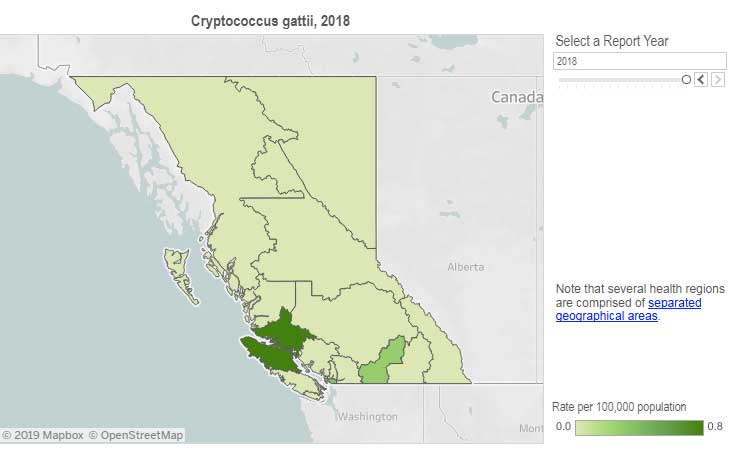
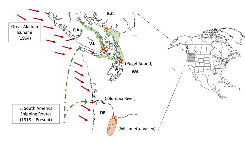
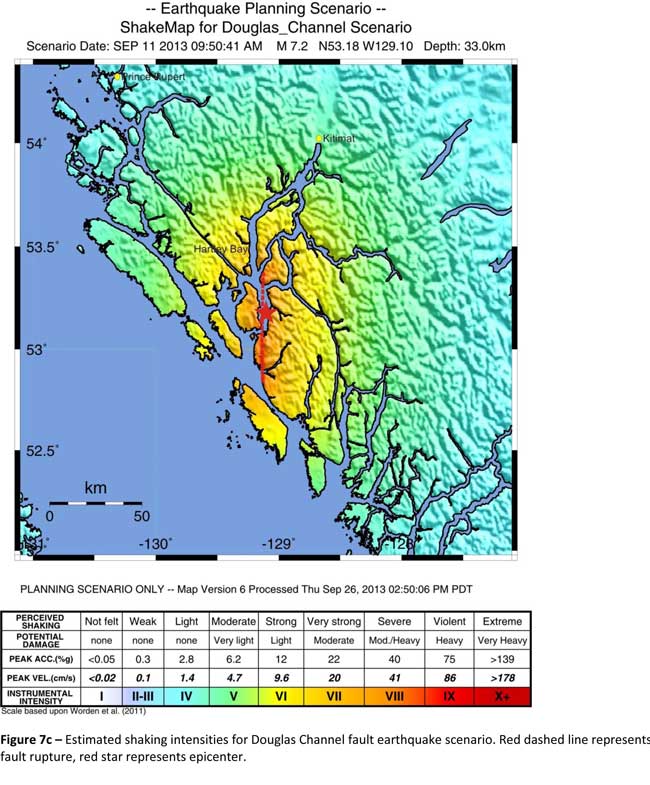

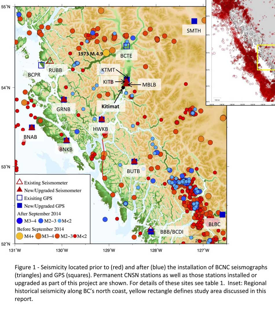

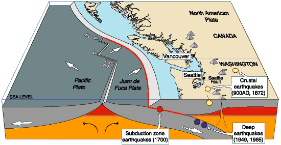


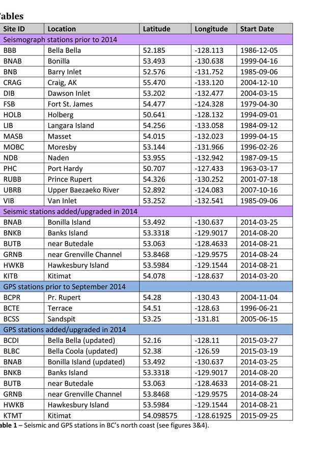
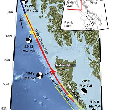


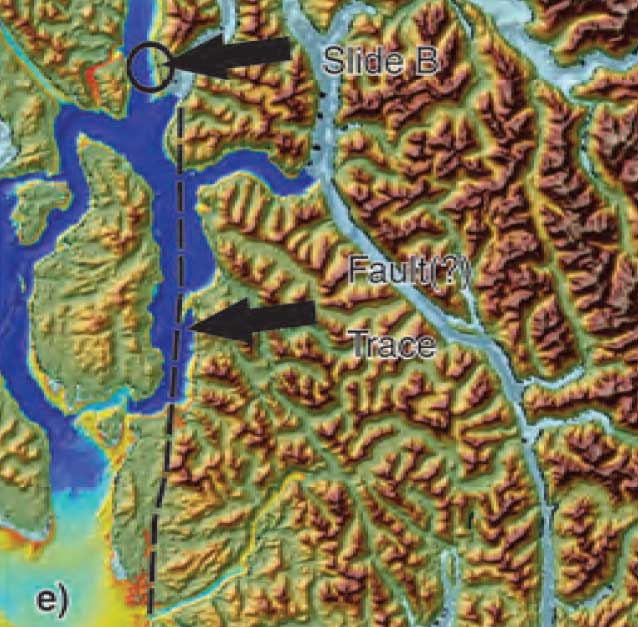


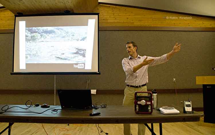
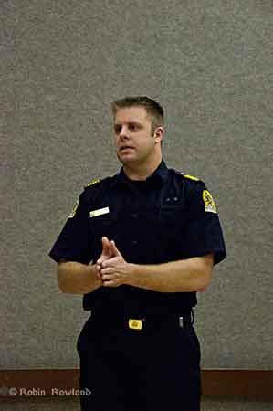
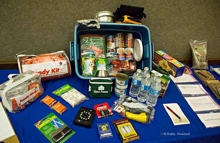
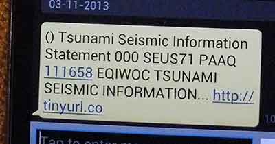
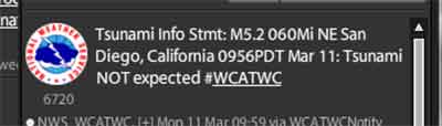
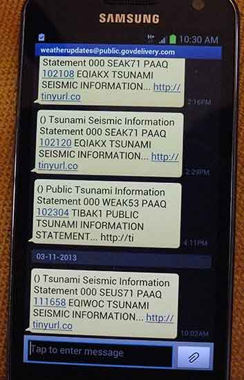


