Salmons’ extra large guts are a survival tactic

Coho salmon Based on the drawing from Silver o...

Image via Wikipedia

Environment Fishery Science

Salmon have extra large guts–up to three times larger than its body would suggest–that help it survive, scientists at the University of Washington say.   

The study “Excess digestive capacity in predators reflects a life of feast and famine”   is published in Nature.

A news release from the university calls the large gut a “previously unrecognized survival tactic.” Although fishers who gut a salmon may say that no one noticed how big the gut actually was as they threw it away, the same apparently applied to scientists as the article states:  “Despite …basic principle of quantitative evolutionary design, estimates of digestive load capacity ratios in wild animals are virtually non-existent.”

The study is by PhD student  Jonathan “Jonny” Armstrong, originally from  Ashland, Ore, who says he has been fascinated by salmon ever since he saw a Chinook leap out of the water when he was ten.

The study says that when the “foraging opportunities for animals are unpredictable, which should favour animals that maintain a capacity for food-processing that exceeds average levels of consumption (loads), The study  that piscine  [fish] predators typically maintain the physiological capacity to feed at daily rates two to three times higher than what they experience on average…”

“This much excess capacity suggests predator-prey encounters are far patchier – or random – than assumed in biology and that binge-feeding enables predators to survive despite regular periods of famine,” Armstrong said. Co-author and supervisor on the paper is Daniel Schindler, University of  Washington  professor of aquatic and fishery sciences.

“Guts are really expensive organs in terms of metabolism,” Armstrong said. For instance, maintaining a gut can require 30 to 40 per cent of the blood pumped by an animal’s heart.

Some animals have some capacity to grow or shrink their guts in response to changing conditions. For example, according to previous studies,  the digestive organs of birds that are about to migrate expand so they can eat more and fatten up. This is followed by a period when their guts atrophy and then, freed of the baggage of heavy guts, the birds take off. But this study shows  that many fish species maintain a huge gut, which enables them to capitalize on unpredictable pulses of food.

Ravens and crows, for example, are known to cache food far from where they find it. Fish can’t do that. “Unlike some other animals, fish can’t just hoard their food behind a rock in the stream and eat it later. They need to binge during the good times so that they can grow and build energy reserves to survive the bad times,” Armstrong says.

Armstrong is part of the university’s School of Aquatic and Fishery Sciences  which has a field site at the Alaska Salmon Program’s Lake Aleknagik. Using a dry suit, Armstrong snorkeled the Aleknagik tributaries, swimming in waters as low as 5°C where he found out  the Aleknagik streams exhibited tremendous variation in water temperature, which inspired him to study how those temperatures affected the ecology of the streams.

In his initial studies, he looked at the effect of water temperature on juvenile coho’s ability to consume sockeye eggs. He says, “In cold streams, juvenile coho salmon were too small to fit the abundant sockeye eggs in their mouths. In warmer streams, the coho grew large enough to consume eggs, gorged themselves, and achieved rapid growth, and this suggested that small changes in temperature can have disproportionate affects on coho salmon production.”

 The “previously unrecognized survival tactic”  might apply to other top predators, such as wolves, lions and bears,  Armstrong says.

Enhanced by Zemanta

Kitimat takes halibut fight to BC municipal convention

Environment Fishery

528-rowland_halyk2.jpg

District of Kitimat councillor Randy Halyk, seen here at the local Jack Layton memorial on August 27, 2011, will be defending Kitimat’s resolution on halibut quotas at the Union of BC Municipalities convention.   (Robin Rowland/Northwest Coast Energy News)

Kitimat is taking the fight over halibut allocation to the Union of British Columbia Municipalities convention to be held in Vancouver September 26 to September 30.

The resolution is one of two that the union will consider on the halibut controversry, the other comes from the Capital District on Vancouver Island,

Members of the District of Kitimat council will be at the convention to sponsor and defend the resolution.

The Kitimat resolution calls on the union to endorse:

Whereas the current federal allocation of the sustainable Pacific halibut resource is insufficient to provide reasonable catch and possession limits for the recreational and commercial sport fishery;

And whereas an increase in daily catch and possession limits would be of great benefit in attracting sports fishing tourists to coastal communities.

Therefore be it resolved that the UBCM support an increase in the allocation of the sustainable Pacific halibut resource to the sport fishing and requests that the federal Ministry of Fisheries and Oceans increase the catch limits to two per day and four in possession.


 The Kitimat resolution was endorsed by the North Central Local Government Association

 The overall province wide resolutions committee gave no recommendation on the Kitimat resolution saying it wasn’t clear what impact the resolution would have on the sports fishing industry. The committee added a note to the agenda that in 2010 members of the UBCM did endorse a resolution that requested the provincial and federal governments support both the commercial fishing industry and the sports fishing industry equitably as they are both critical economic generators for residents within the province.

The resolutions committee notes that British Columbia did express “support for the sustainability of both commercial and recreational fisheries in tidal waters.” The province apparently “highlighted a number of its activities related to ensuring fisheries sustainability and maximizing the economic and social benefits.”

The somewhat stronger resolution from the Capital Region did not receive an endorsement from the Association of Vancouver and Coast Communities and a “no recommendation” from the province wide resolution committee. That resolution says, in part that the allocation between the recreational and commercial sectors in the Canadian halibut fishery during years of low abundance will destroy the economic viability of coastal communities and deny Canadian citizens access to the common property resource of halibut.

It calls for a “more fair and equitable approach that would allow the recreational and commercial fishing industries to survive during years of low annual quotas,” it calls for the federal government to purchase or lease halibut quota from the commercial sector (rather than having the recreational sector purchase individually as the current Department of Fisheries and Oceans “pilot project” calls for) so that the recreational sector has a “permanent base limit,” that the season be guaranteed from February 1 to December 1 each year and that the limit be one halibut per day, two in possession. (The Department of Fisheries and Oceans stopped the recreational halibut season as of midnight Sept. 15 while allowing the commercial season to continue).


Earthquake, magnitude 6.4, strikes off west coast of Vancouver Island

Environment Earthquake

 Last updated 1444 PT

525-intensity-thumb-500x586-524.jpg
A 6.4  magnitude earthquake struck off the west coast of Vancouver Island at 12:41 PM PT, Friday, Sept. 9, 2011.  Iniitial reports say there were was no damage or injuries. The US Geological Survey first set the magnitude at 6.7, but that was later revised to 6.4  A 6.4  magnitude is considered a major earthquake.  The quake was not felt in the Kitimat region but was in Vancouver Island towns like Campbell River, Port Alice and Port Hardy.  In the small village of Zeballos, residents gathered quickly at an emergency gathering point, but it was soon clear that danger had passed and there were no injuries. Shaking was felt in Vancouver and Victoria, as far south as Seattle and east to Abbotsford. 

US Geological Survey page on the Vancouver Island earthquake.

The West Coast and Alaska Tsunami Warning Centre has not issued a tsunami alert.


To: U.S. West Coast, Alaska, and British Columbia coastal regions
From: NOAA/NWS/West Coast and Alaska Tsunami Warning Center
Subject: Tsunami Information Statement #1 issued 09/9/2011 at 12:43PM PDT

A strong earthquake has occurred, but a tsunami IS NOT expected along the California, Oregon, Washington, British Columbia, or Alaska coast. NO tsunami warning, watch or advisory is in effect for these areas.

Based on the earthquake magnitude, location and historic tsunami records, a damaging tsunami IS NOT expected along the California, Oregon, Washington, British Columbia, and Alaska coasts. Some of these areas may experience non-damaging sea level changes. At coastal locations which have experienced strong ground shaking, local tsunamis are possible due to underwater landslides.

The USGS says the epicentre was 119 km WNW of Ucluelet, 138 km WSW of Campbell River, 140 km SSE of Port Hardy and 289 km WNW of Victoria.

 US Geological Survey maps showing history of earthquakes off Vancouver Island.

Earthquakes Canada information page from Natural Resources Canada.

Emergency Info BC


Northwest coast hazards


526-hazardmap.jpg
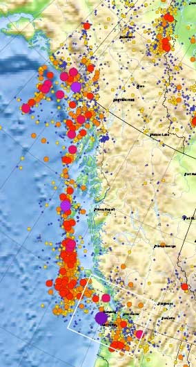
This detail of the Natural Resources Canada/ Earthquakes Canada shows the historical record of earthquakes along the northwest coast of British Columbia. The larger the circle, the greater the magnitude.

Most, not all, the earthquakes took place in the tetonic plate boundaries off the coast in the middle of the Pacfic Ocean, although the map does also show quakes on Haidi Gwaii. However, large quakes can be felt far inland.  The magnitude 9.2 Good Friday earthquake in Alaska in 1964 did shake the town of Kitimat.


Media links

CBC :Earthquake strikes off Vancouver Island’s west coast

Global BC 6.4 earthquake hits off Vancouver Island

Globe and Mail
6.4 earthquake hits off Vancouver Island

Kelp has great potential as green biofuel studies suggest

Energy Environment Biofuel

522-tywynsurf.jpg
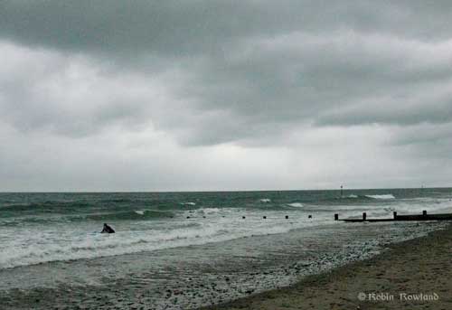
A surfer enters the water on a stormy beach at Tywyn, Wales, July, 2008.  Scientists from nearby Aberystwyth University  have studied kelp as a potential biofuel. The kelp was growing near a rocky outcrop some kilometres south of  Tywyn at Aberystwyth Beach near Ceredigion.  (Robin Rowland/Northwest Coast Energy News)


Kelp has potential as a renewable biofuel resource because it is a fast-growing, large “macro-algae” that could be harvested, processed and turned into ethanol, methane or bio-oil, according to a recent study in Wales.

The study by Jessica Adams  and colleagues at Aberystwyth University in the west of Wales was presented at a biology conference in Glasgow on July 4, 2011 and published in the journal Bioresource Technology.

Coastal Wales has a similar environment to the west coast of North America and  both regions are abundant in kelp.

In her paper, Adams says that most biofuels today come from terrestrial sources such as agricultural products or forests, and both sources can cause environmental problems.  Harvesting kelp  for biofuel would mean that potential food crops,  such as maize, would not be taken out of the food supply chain. She says the ocean  accounts for half of the primary biomass on the planet, but has not been used very much in the search for biofuel.

Her study, assisted by the Energy and Resources Institute at the University of Leeds, concentrated on the potential that kelp has for producing fuel at various times of its life cycle during the year.


View Larger Map


By analyzing the chemical composition of kelp harvested  at low tide at rocky outcrop on Abesrtystwyth Beach, Ceredigion, Wales, Adams and her colleagues determined the best time to harvest the kelp for use as potential biofuel, which in the case of Wales, was in July when the kelp had the highest levels of carbohydrates, including two key sugars, mannitol and laminarn, which are easily converted to biofuel. Those carbohydrates could be fermented or put through anaerobic digestion to produce either ethanol or methane. Another method is pyrolysis,  a method of heating the fuel in the absence of oxygen, which can produce bio-oil.

Another advantage that kelp has over terrestrial plants is that it contains little cellulose and thus is easier to handle when creating biofuel.

The First Nations of British Columbia used the kelp for centuries, as a place to find  fish, crustaceans and shell fish in the kelp beds or to hunt seals that fed on the fish. In some parts of the BC coast, First Nations used kelp branches to harvest herring roe  (before the collapse of the herring stocks)

 For the past century, modern use has concentrated on the minerals the kelp produces,  it was burned to obtain soda ash (sodium carbonate) , used for the production of soap, ice cream and lotions as well as in some processes for making glass. 

Kelp is increasingly popular as a health food, both as an edible seaweed and for health supplements.   In British Columbia, kelp is harvested  for health food at a time of peak mineral content, when the content is  25 per cent to 50 per cent minerals,  including potassium, calcium, magnesium, phosphorus and iodine. Salt extracted from BC kelp is high in potassium and thus attractive for people on low sodium diets.

For biofuel, however,  the time when kelp is highest in minerals, and thus attractive to the current harvesters, is not the time it would be best for biofuel.  Adams says: “Seaweed ash has previously been reported to contain, potassium, sodium and calcium-carbonate  and high concentrations will lead to increased slagging, fouling and other ash related  problems during thermochemical conversion.”

In Wales, Adams’ study showed that the mineral concentration in the kelp peaked in March and was lowest in July, a time when the carbohydrate content is also higher.  She says   “This means that a July harvest would provide the highest heating value and the lowest ash  and alkali index values, making it the best month for harvesting  for thermochemical conversion.”

It appears also that cleaner water will produce kelp that is better suited to biofuel conversion, since the kelp her study used from Cardigan Bay had a lower mineral content than kelp from areas off Cornwall where effluent from the tin mines was carried by rivers into the ocean in that region.

An earlier small pilot project in 2008 at a royal estate on the north coast of Scotland looked into the possibility of setting up a kelp farm that could potentially used for biofuels.  That project showed that using kelp for biofuel meant that agricultural land did not have to be taken out of production for biofuel planting and even that agricultural runoff could be used to fertilize a concentrated kelp farm.

The species of kelp used in the Welsh study had high concentrations of both water and minerals and  that is whyJuly was the optimal time for a possible biofuel  harvest.  Other species, in other areas,  once studied, might be better suited to be used as biofuels. Adams concludes by saying: “Macroalgae or macroalgal residues could pryrolysted to create a bio-oil or used in hydrothermal liquefaction to make bio-crude  in a process which does not require the initial drying of the feedstock.”

523-haidaqwaiikelpmap.jpg
Map of the kelp beds on the north coast of Haida Gwaii, taken from the BC provincial government kelp inventory survey.

Correction: An earlier version of the story said the journal was Biosource Technology. This has been corrected to Bioresource Technology.

Shell considering giant floating LNG platform off BC Coast: Alberta Oil

Energy LNG  Link

Alberta Oil is reporting that Shell’s plans for a liquified natural gas export facility somewhere on the northern British Columbia coast will likely be a giant floating platform, similar to the platform planned for the coast of Western Australia.

Shell Canada sizes up LNG options offshore B.C.

Although costs, production volumes and timelines haven’t been worked out, industry observers like FirstEnergy Capital are speculating that Shell and its partners are considering building a floating LNG structure off B.C.’s coast. The Anglo-Dutch super-major knows a thing or two about floating LNG projects. In May, Shell received approval from the Australian government for its Prelude floating LNG project. Scheduled to start production in 2016, the Prelude structure will be located in the Browse basin off the coast of Western Australia

The length of the floating prelude platform, at  488 metres according to a diagram released by Shell and reprinted by Alberta Oil, would be longer than the height of the 446.5 metre Skypod/ Space Deck on the CN Tower and longer than the hieght of Kuala Lumpur’s Petronas Tower at 452 metres.  (The proportions in the Shell diagram of the CN Tower are not entirely accurate when compared to the information in the Wikipedia entry on the CN Tower)
518-tall_lng-thumb-500x454-517.jpg As reported in April by Alberta Oil Kitimat LNG faces Australian rivals the Western Australian development could rival Kitimat, a point that took up a lot of testimony at the June National Energy Board hearings into KM LNG’s application for an export licence.

Enhanced by Zemanta

Micro organisms played key roles in Exxon Valdez, BP cleanup: study

Environment Link

A study by the U.S. Lawrence Berkeley National Laboratory is reporting that microbes, mostly  bacteria, but also archaea (single cell organisms without a cell nucleus) and fungi, played key roles in mitigating both the Exxon Valdez oil spill in Alaska and the  BP Deep Ocean Horizon disaster in the Gulf of Mexico.

In a news release, Terry Hazen, microbial
ecologist with the Lawrence Berkeley National Laboratory (Berkeley Lab) says, “Responders to future oil spills would do well to mobilize as rapidly as
possible to determine both natural and enhanced microbial degradation
and what the best possible approach will be to minimize the risk and
impact of the spill on the environment.”

Hazen, who leads the Ecology Department and Center for Environmental
Biotechnology at Berkeley Lab’s Earth Sciences Division and  has studied
microbial activity at both spill sites, published the paper with colleagues in Environmental Science & Technology. The paper is titled “Oil biodegradation and bioremediation: A tale of the two worst spills in U. S. history.”

The authors say that hydrocarbons have been leaking into the marine environment for millions of years and so “a large and diverse number of microorganisms, including bacteria, archaea and fungi, have evolved the ability to utilize these petroleum hydrocarbons as sources of food and energy for growth.”

Such microorganisms are only a small part of a pre-spill microbial community in any given ecosystem. Hazen says in both the Exxon Valdez and the BP Deepwater Horizon spills, the surge in the presence of crude oil sparked a sudden and dramatic surge in the presence of oil-degrading microorganisms that began to feed on the spilled oil.

“In the case of the Exxon Valdez spill, nitrogen fertilizers were applied to speed up the rates of oil biodegradation,” Hazen says. “In the case of the BP Deepwater Horizon spill, dispersants, such as Corexit 9500, were used to increase the available surface area and, thus, potentially increase the rates of biodegradation,” he says.

According to the study, within a few weeks of the spill, about 25 to 30 per cent of the total
hydrocarbon in the oil originally stranded on Prince William Sound
shorelines had been degraded and by 1992, the length of shoreline still
containing any significant amount of oil was 6.4 miles, or about
1.3 per cent of the shoreline originally oiled in 1989.

Microorganisms also played a similar role in the Gulf of Mexico Deep Ocean Horizon disaster, despite major differences in the temperature, environment, ocean depth and length and type of spill, the study says.  Hazen and his research group were able to determine that indigenous
microbes, including a previously unknown species, degraded the oil plume
to virtually undetectable levels within a few weeks after the damaged
wellhead was sealed.

The study concludes that decisions as to whether to rely upon microbial oil biodegradation or whether to apply fertilizers, dispersants, detergents and/or/other chemicals used in environmental cleanup efforts, should be driven by risk and not just the presence of detectable hydrocarbons.

Enhanced by Zemanta

Is that halibut playing a smart phone video game?

Environment Fishery


514-nr20110822_tagsm-thumb-500x256-513.jpg

The International Pacific Halibut Commission is trying a new way of tracking halibut migration using technology invented for smart phones and tablets.

The same high tech that lets your smart phone or tablet know the screen should be horizontal or vertical may help the commission, responsible for the conservation of halibut from the Bering Sea along the Alaska and BC coasts all the way to California, track the migration of the valuable and possibly threatened groundfish.

Commission scientists have tagged 30 halibut in areas 3A (roughly the Gulf of Alaska) and 2C  (the Alaska panhandle north from the Canadian border)  with a combination of external electronic “backpack tags” and electronic internal “gut tags”

The IPHC says the backpack  tag is a black plastic cylinder that measures ~3″ (7.6 cm) long by ½” (1.2 cm) in diameter, It is attached to the dark side of the fish, below the dorsal fin, using a green-coated tagging wire, with a white backing plate that rests on the underside of the fish. Gut tags are surgically implanted in the gut cavity, but have a translucent green stalk that protrudes from the belly on the fish’s dark side. The stalk is made of Teflon, and contains sensors that record ambient light levels.

The  commission says the purpose of the study is to examine whether geomagnetism can be used as a means of tracking halibut migrations.

The tags record the local magnetic field in ways that can be converted into location estimates, based on the strength of the magnetic  field and magnetic declination angle in relation to the poles (which gets steeper closer to the poles) in combination with depth and light data.  The “the pitch and roll detectors” in the phones and tablets that can also track the “the rolling bead in the maze game”  do all the calculations needed to track the fish tag.

Since the halibut feeds on the relatively horizontal bottom of the ocean, the angle of the earth’s crust in relation to the poles should be able to track the migration without the use of GPS which cannot penetrate the ocean depths.

All data is recorded in the tag’s memory and can be retrieved if the fish is harvested. There is enough memory and battery capacity that the data can be recorded every 30 seconds for up to seven years. The IPHC is offering a $500 reward to fishers who may catch the halibut to  return both tags.

If the pilot project is successful, the IPHC will tag another 2,000 halibut along the coast from Oregon to the US-Russia border in the Aleutians.

IPHC News release and fact sheet on halibut tagging  (PDF)   Webpage
 

DFO closes recreational halibut fishery as internal memo warns of “significant economic impacts in the fishery”

Environment Fishery
Originally posted  Aug 23, 2011  1:15 PT
Updated Aug. 23, 2011, 2104 PT.

.Just after noon on August 22, 2011, the Department of Fisheries and Oceans  quietly announced that the it was closing the Pacific region  recreational halibut fishery as of  midnight Sept. 5,  2011 cutting off charter, lodge and recreational anglers from the fishery.

The commercial halibut fishery will continue, as planned, until November 18, 2011.

At the same time, DFO continued the highly controversial program of allowing those recreational fishers who can afford it to “‘lease” quota from the commercial fishery.

The closure notice posted on the DFO website on August 22. says:

Throughout the 2011 recreational halibut fishing season, the Department has reviewed in-season monthly catch estimates for the recreational halibut fishery. Catch information indicates that the recreational share of the Total Allowable Catch will be achieved in August. Therefore, recreational fishing for halibut under the BC tidal water licence will close effective 23:59 hours September 5, 2011 for the balance of the year. 2012 management actions will be developed this fall and announcements will be made in early 2012.
 Variation Order 2011 – 404 is in effect

DFO did not issue a news release on the closure and the opportunity to
lease, instead only posting the notices on the official notices to
fishery site. That meant that many recreational fishers did not learn
about the closure until the story broke in the British Columbia news
media almost 24 hours later.

Yet at the very same time, DFO did issue a news release,  at 155 pm, also on August 22, about a shell fish closure on the St. Lawrence.

 It is the earliest date that the recreational halibut fishery has been closed. Last year, the recreational halibut fishery closed on October 18.

Although the  total halibut biomass is considered healthy over the long term,  the stocks are low at the moment, probably due the lifecycle of the fish, and most of the existing stock is usually too small for harvest.

An internal memo from the Department of Fisheries and Oceans, dated  Sept. 1, 2010, obtained by Northwest Coast Energy News under the Access to Information, outlined three possible closure dates for the recreational halibut fishery in 2010.

The memo gave the deputy minister three options for that year,  September 1, October 1 and “no closure” which would mean that the closure would have come on the traditional date of  December 1.

The documents predict the consequences for the recreational fishery if it was closed on Sept. 1, 2010 consequences that are likely to happen this year.

“An end of August closure does not allow time for the recreational  community  to make contingency plans or to inform clients in a timely manner,”  a problem that recreational fishers and charter operators   have been predicting since the protest meetings last winter.

Since 2003, the Canadian halibut harvest has been divided between the commercial fishery, which gets  88 per cent and the recreational fishery, which includes lodges, charters and individual anglers at 12 per cent.  The recreational fishery has disputed that division since it began.  The recreational halibut fishery has generally exceeded its quota for the past few years.

Thus the DFO memo says that: “Closing the recreational fishery  at the end of August  would reduce the potential  recreational fishery overage significantly. This would assist in Canada’s commitment  to managing within the TAC” (the total allowable catch set by the International Pacific Halibut Commission which sets catch limits for the Pacific US states, British Columbia and Alaska)

The DFO memo adds that an end of August closure would: “Although the recreational  fishing community has been advised of a possible in-season  closures, there will be significant economic impacts in the fishery  and there are concerns about the regular sports fishermen  who continue to  fish in the latter part of the year.”

(more to come)

“Front End Engineering” begins for BC LNG

Energy

The Hart Energy  E&P (exploration and production) newsletter is reporting that an Overland,  Kansas based company, Black & Veatch,  a multi-billion dollar, employee-owned engineering firm founded in 1915,  is beginning front end engineering (FEED) for the second proposed Kitimat liquified natural gas facility, BC LNG.

Although no information appears on the Black & Veatch website, the newsletter quotes Tom Tatham, the managing director of  Douglas Channel Gas Services Ltd, the company which will contract with energy firms wanting to export through the BC LNG facility as saying:  We are looking to build the majority of the LNG export facility on a standard Panamax barge to minimize the physical and environmental impact in this scenic area.”

(The name Panamax derives from the maximum size that a barge or ship can be to pass through the Panama Canal, which means the LNG from the port of Kitimat could be shipped to anywhere in the world, not just to the projected Asian market)

 Black & Veatch has developed a process called PRICO which Tatham says  is ideal for this type of application because of its smaller footprint and flexible operations.

Black & Veatch’s engineering planning is scheduled to be complete by January 2012 and will provide a “definitive estimate” that will be used for costing  engineering, procurement, construction, testing and commissioning of the facility.

The newsletter quotes  says Dean Oskvig, president and CEO of Black & Veatch “The global LNG export market is extremely cost-competitive,” and  Oskvig says the company`s process will be scalable and thus allow the partnership to bring liquified natural gas to market at a competitive price.

The Black & Veatch website briefly promotes  the PRICO process as simple, flexible, reliable and economic but gives few details.

The company has an Edmonton based Canadian subsidiary.


Enhanced by Zemanta