Kitimat can accommodate industrial growth, air shed study says. But where’s Northern Gateway?

The long awaited Kitimat air shed study, released by the province Friday, July 17, 2014,  says “that with proper management, Kitimat’s ai rshed can safely accommodate new industrial growth” without major affects on either human health or the environment.
Link to news release : Study shows Kitimat airshed can handle new industrial development 

The Kitimat Airshed Assessment looked at the cumulative effects of industrial air emissions, primarily sulphur and nitrogen oxides, and their potential impacts on both human health and the environment from

  • Rio Tinto Alcan’s existing aluminium smelter and its planned modernization
  • David Blacks proposed “Kitimat Clean” oil refinery at Onion flats
  • Four proposed LNG facilities; Shell-led LNG Canada, Chevron lead Kitimat LNG, the floating Douglas Channel LNG at the old log dump and a second floating LNG project called Triton.
  • BC Hydro gas turbine powered electrical generation facilities in Kitimat and near Terrace
  • Predicted increased to marine shipping in Douglas Channel.

The study was divided into two zones.

Health results were first examined for Kitimat townsite, the Kitimat Industrial Service Centre and Kitamaat Village.

The wider study included Gitga’at Old Town, Hartley Bay (Kulkayu), Kitimat-Stikine, Kitselas, Kitsumkaylum, Kshish, and Terrace.

Enbridge missing

There was one big factor missing from the study, it does not include the Enbridge Northern Gateway project, although the consultants who did the study do cite a couple of the air quality studies that Enbridge filed with the Northern Gateway Joint Review Panel. That despite the fact the Joint Review Panel under Condition 82 required that Enbridge file with the NEB for approval, at least four months prior to commencing construction, “an Air Quality Emissions Management and Soil Monitoring Plan for the Kitimat Terminal.”

The JRP report acknowledged that emissions from the Enbridge terminal would be minimal but would contribute to the cumulative effect of pollutant emissions from other industries and required Enbridge to consult with the District of Kitimat, the environment ministries and other industries in planning for emissions.

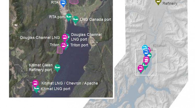
The map from the airshed study also shows that the  possible marine terminal for David Black’s proposed Kitimat Clean refinery project is at or close to where the proposed Enbridge Northern Gateway terminal would be.

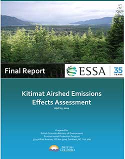
airshedcover

Health and environment

The study looked at proposed emission levels and the effect of emissions elsewhere in the world and then compared those studies with the Kitimat Valley. It found that the risk of sulphur dioxide was “directly related to proximity to industrial area”–largely the Kitimat Service Centre area–and that there would be a minor increase in respiratory incidents of 0.5 per cent to 2 per cent, with a slight increase of nitrogen dioxide but those were within existing guidelines.

As for environmental impact, the study says nitrogen dioxide impacts will be low. There wil be “some increased risk of soil impacts” from sulphur dioxide. The study says there will be “no negative impacts to vegetation across all scenarios” but did find “potential for acidification” of seven small lakes.  Lakelese Lake is not one of those affected.

The study also doesn’t include particulate matter and although it does consider climate change, did not take into consideration possible increase of green house gases in the Kitimat Valley.

The consultants, Esssa Technologies of Vancouver, based its findings on an earlier study by Rio Tinto Alcan on emissions from the Kitimat Modernization Project and worked on those findings by adding new industries and a greater area to the models they used.

The province and industry says they will continue to monitor air, water, soil and vegetation “to ensure these values are protected.”

The higher levels of sulphur dioxide emissions from the Rio Tinto Alcan Kitimat Mondernization Project will be allowed to continue under the current permit. Environment Minister Mary Polack told reporters that will only change if the current court challenge to the sulphur dioxide levels are successful.
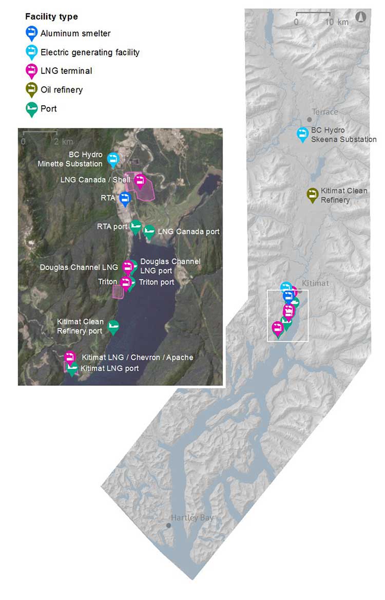
 

Map of Kitiamt
A map by Essa Technologies and Environment BC of the Kitimat valley airshed study shows locations for existing and proposed industrial or infrastructure development. It does not include the proposed Enbridge Northern Gateway project.
What Northern Gateway Joint Review said about emissions in the air shed
Among the 209 conditions imposed on the Enbridge Northern Gateway project is No. 82, an Air Quality Emissions Management and Soil Monitoring Plan.

Northern Gateway must file with the NEB for approval, at least 4 months prior to commencing construction, an Air Quality Emissions Management and Soil Monitoring Plan for the Kitimat Terminal…

This plan must include:
a) a description of the baseline, pre-construction conditions, informed by relevant modelling results and recent, existing monitor data;
b) locations of both air and soil monitoring sites on a map or diagram, including the rationale for the locations selected and the timing for installation;
c) methods and schedule of ambient monitoring for contaminants of potential concern in air (e.g., NO2, SO2, and H2S) and in soils (e.g., pH; major plant nutrients K, P, N, and S; and trace metals), and emissions source tracking;
d) data recording, assessment, and reporting details;
e) a description of the public communication and complaint response process;
f) additional measures that will be implemented as a result of monitoring data or ongoing concern;
g) the criteria or thresholds that will require implementing additional measures;
h) a description of the plan updating process;
i) a summary of Northern Gateway’s consultation with Environmental Canada and the British Columbia Ministry of Environment regarding the Air Quality Emissions Management and Soil Monitoring Plan. This summary must include any issues or concerns raised regarding the plan and how Northern Gateway has addressed or responded to them; and
j) a summary of discussions with the District of Kitimat and local or regional industrial emitters regarding collaborating on the plan’s design and implementation.

One of the things that the Joint Review Panel noted in requiring Enbridge Northern Gateway to have an updated plan and to collaborate with Kitimat and other industries is that levels of acceptable sulphur doixide in the atmosphere are changing and much of Northern Gateway’s modelling was based on standards that were becoming obsolete.

In the Joint Review Panel report, section 8.7, the JRP said:

Northern Gateway assessed changes in the atmospheric environment, including a modelled assessment of criteria air contaminant, hazardous air pollutant, and greenhouse gas emissions. Criteria air contaminants assessed by modelling included sulphur dioxides, nitrogen oxides, carbon monoxide, hydrogen sulphide, and particulate matter. Hazardous air pollutants were also modelled and included total volatile organic compounds (VOCs), benzene, toluene, ethylbenzene, and xylene (combined, BTEX), as well as hydrogen fluoride.

The provincial air shed report considered only two contaminants, sulphur dioxide and nitrogen dioxide.

Northern Gateway said there would be minimal atmospheric emissions from the construction and operation of the pipeline. The focus was on the Kitimat marine terminal.

The modelled assessment for the Kitimat Terminal included emissions associated with terminal operations, with the largest sources being vehicle traffic and
hydrocarbon storage tanks Northern Gateway used the conservative assumption of continuous ship berthing…emission rate) in order to capture the worst case scenario of concurrent adverse meteorology and maximum potential emissions. From the model results, Northern Gateway predicted that sulphur dioxide associated with operating the Kitimat Terminal would exceed the provincial air quality objectives (Level A) for all time periods. This after mitigation.

Environment Canada said that Northern Gateway took appropriate measures in designing and siting its proposed facilities to minimize adverse effects on air quality. It acknowledged Northern Gateway’s commitments to adopt best practices and to use economically-feasible best-available technologies in designing the Kitimat Terminal to minimize effects on air quality.

Northern Gateway ackknowledged that “due to the project interacting with nearby topographical features, where the largest sulphur dioxide emissions are from the
marine vessels, the highest concentrations were predicted to occur infrequently and immediately adjacent to the terminal fence line.

Northern Gateway, Transport Canada, the Heiltsuk First Nation and other stakeholders did acknowledge that eventually the vessels coming to Kitimat “would be subject to the reduced sulphur fuel requirements associated with the joint United States-Canada North American Emission Control Area.

Based on this, marine fuel sulphur requirements permitted in Canadian coastal waters (200-nautical-mile limit) would be 1.0 per cent in 2012, reducing further to 0.1 per cent by 2015. Northern Gateway predicted that sulphur dioxide emissions from marine vessels should be approximately 96 per cent lower than modelled once these new international fuel standards take effect. Northern Gateway also predicted exceedances of provincial air quality objectives in the area for carbon monoxide, particulate matter, hydrogen sulphide, and total reduced sulphur.

Northern Gateway said there “no exceedances of hazardous air pollutant guidelines were predicted as a result of the project itself” but there could be a cumulative effect with other industries in the Kitimat waterfront.

The Joint Review Panel ruled:

By the Kitimat Terminal’s proposed in-service date, there will have been significant changes to the number and magnitude of existing air emission sources since
the provincial emission inventory of 2000 was compiled, and since Northern Gateway completed its modelling assessment.

Regarding the sulphur emissions attributable to the terminal, marine vessel berthing would account for 97 per cent. Given that Northern Gateway used conservative assumptions regarding berthing in the modelling and that regulations coming into force regarding the sulphur content of marine fuels would further decrease predicted missions, the Panel finds that the modelling results presented in the application and subsequent filings are not predictive of the realistic potential effects on local air quality.

Based on the filed information about sulphur dioxide emissions, the Panel is satisfied that new modelling based on the updated information would indicate that sulphur dioxide associated with the Kitimat Terminal’s operations would not exceed provincial air quality objectives.

The Panel requires that further modelling, reflecting the current level of activity, equipment, and marine sources, must inform Northern Gateway’s design of the Air Quality Emissions Management and Soil Monitoring Plan for the Kitimat Terminal.

Updated modelling would be used to inform the monitoring program’s design, as well as to help ensure that the monitors are placed effectively to monitor both human and environmental health.

Cumulative effects on the atmospheric environment

Northern Gateway said that, during the Kitimat Terminal’s operations, tank maintenance and marine berthing would add a potential measureable contribution to regional cumulative environmental effects from air emissions. Northern Gateway incorporated the existing industrial sources in the Kitimat area in its modelling assessment, using the British Columbia Ministry of Environment’s emissions inventory. At the time the modelling was run, the available emission estimates from 2000 were used to characterize the existing sources in the airshed.

The Joint Review panel noted that over the time of the hearings”it heard of many changes to the industrial make-up of the Kitimat area since the 2000 emissions inventory was developed.”

Combining these with the predicted project emissions, the model results indicated predicted exceedances of regulatory thresholds for sulphur dioxide, carbon monoxide, particulate matter, hydrogen sulphide, and total reduced sulfur, though not at every averaging period.

Northern Gateway said that, due to the existing large emission sources and the region’s complex meteorology and topography, the exceedances are primarily attributable to the other industrial activities around Kitimat and not from the project itself.

Because there would be adverse project effects remaining after mitigation that could combine with the effects of other past, present, and future projects, and because cumulative effects are of primary concern, the Panel’s significance recommendation is given below in its analysis of cumulative effects.

The Panel finds that the emissions associated with the Kitimat Terminal’s operation would be minimal compared to the existing sources presented.

Although the modelled cumulative emissions exceeded many regulatory thresholds, the exceedances were predicted based on an out-of-date emissions inventory, and were predicted to occur prior to adding emissions from the project. Based on the information about sulphur dioxide emissions on the record, in addition to the modelling included in the application, the Panel is satisfied that new modelling based on updated information would indicate that sulphur dioxide associated with the Kitimat Terminal’s operations would not contribute to an increased exceedance of provincial air quality objectives, either through limited emissions or berthing management to limit emissions in particularly adverse conditions.

Related

Kitimat air shed study raises more questions than it actually answers
Tanker study shows huge gaps in shipping and hazard data, documents show

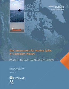
The study of tanker shipping and tanker spills by Genivar for Transport Canada has revealed huge gaps in how the world monitors tanker traffic.

Genivar report
Cover of Genivar tanker report (Transport Canada)

Genivar says

Accident data was acquired from three main sources: the CCG Marine Pollution Incident Reporting System (MPIRS); the Lloyd’s casualty database; and spill incident records maintained by the International Tanker Owners Pollution Federation (ITOPF).

MPIRS lists all marine pollution incidents occurring in Canadian waters (CCG, 2013), with information on the region within Canada in which the incident occurred, type of material spilled, accident cause, and estimated pollution volume with multiple entries for a given incident showing updates of incident status and pollution amounts if applicable. The primary use of MPIRS in this study was for spill incidents in the smaller size categories… for which worldwide data was suspected to be unreliable due to under-reporting. MPIRS appeared to be a comprehensive listing of incidents that occurred in Canadian waters, and a summary of polluting incidents

It goes on to note that some key data has not been updated since the 1990s, largely prior to the introduction of double hulled tankers.

As noted, oil spill accidents were compiled on a worldwide basis.

In order to estimate the frequency for Canada, an exposure variable was required.

A series of studies by the U.S. Minerals Management Service (MMS, now known as
the Bureau of Ocean Energy Management, Regulation and Enforcement) investigated the occurrence rates of tanker accidents against various spill exposure variables and found that the simplest and most reliable indicator was volume of oil transported. Simply put, it was determined that spill rates could be expressed, for a range of spill size categories, as an average number of spills per billion barrels transported.

The MMS studies were updated periodically until the 1990s but have not been revisited since, but they did show a steady decrease in the likelihood of casualties and resulting spill volumes, due to a number of factors including tanker design, increasing governance and overall scrutiny of the marine transportation industry. The phased-in implementation of double-hull tankers may have also had a beneficial effect on spill rates in more recent years, particularly in the category of very large or catastrophic events… In any case, it is important in interpreting accident data to reflect current trends and implemented mitigation measures. The focus was on cargo volumes and accident rates over the past decade.

It goes on to say the volumes of crude carried is also under-reported to Lloyds.

In the case of crude oil and refined products carried as cargo, the exposure variable was simply the volume of each respective category carried on an annual basis for the period of interest. Information from the Lloyds APEX database was used for this purpose; it reports volumes of crude and refined products shipped worldwide, with a breakdown by year, country of origin, and country of destination. Compared with similar data from Canadian sources, the APEX data appeared to significantly under-report the carriage of refined products. As a result, the accident rates estimated and used in this study are likely somewhat conservative, that is, they overstate the likely frequency of refined products carried as cargo. For all calculations involving the potential spillage of refined products as cargo in Canadian waters, and for the apportioning of spill frequency among the various sectors and sub-sectors of Canada, Transport Canada commodity traffic data was used

Again about Lloyds data, until 2010, it was limited in its monitoring of the BC Coast.

In analyzing the Canadian movement data supplied by Lloyds, a major shortcoming was found in the data in that movements recorded prior to 2010 did not include broad classes of vessels such as ferries, passenger vessels, and pilot boats. Given that these vessels comprise a significant proportion of traffic movement in many sectors, only data covering the final two years of the record, 2010 and 2011, were used in the analysis.

The Lloyds data was also limited when it came to oil spills:

One limitation of the MPIRS data was that it did not classify spills as to whether they were from “cargo” as opposed to “fuel”, which would have been helpful in this study as these spill types were analyzed separately. As a result, for spills of refined products, which could have hypothetically been either cargo or fuel, assumptions were made based on the type of vessel involved, the type and severity of the incident, and other notes within MPIRS.

A database was acquired from Lloyds that detailed all marine casualties over the
past ten years regardless of whether the incident involved pollution…
This database was used to provide a breakdown of incidents by cause, and as an
initial listing of those incidents that did result in pollution. The Lloyds data was of
mixed quality when it came to the reporting of polluting incidents, with numerous
records only partially filled out, ambiguities in the reporting of spill volume, and
inconsistencies in the classification of the spilled material. A significant effort was
made to provide consistency and accuracy in the information, including cross-
referencing with other data sources.


So the Genivar report exposes a significant gap in the available data on oil spills.

It is certainly true that the number of major tanker accidents and spills have decreased since the Exxon Valdez disaster, a point frequently made by Enbridge at meetings in northwestern BC.

The expert panel report which said that Canada faces the risk of a major tanker disaster of 10,000 tonnes or more once every 242 years.

The Vancouver Sun quoted Transport Canada spokeswoman Jillian Glover on that risk of a spill on the Pacific Coast as saying. “This value must be understood in relative terms, such that the risk is considered high compared to the rest of the country only…Canada enjoys a very low risk of a major oil spill, evidenced by the lack of Canadian historical spills in the larger categories. Additionally, this risk assessment is before any mitigation measures have been applied, so that is a theoretical number before additional prevention initiatives are taken.”

Note that the government always talks about a “major oil spill,” but it appears from the gaps in the data that predicting the possibility and consequences of a medium sized or smaller oil spill is now not that reliable, even though such a spill could have disastrous effects on a local area. According to a map in both reports, the entire BC coast is at risk for a “low to medium” spill. This echoes the problems with the Enbridge Northern Gateway pipeline, where Enbridge based most of its projections on a “full bore breach” or major pipeline break and did little about a medium sized or smaller leak. Data analysis by Kelly Marsh of Douglas Channel Watch on the possibility of the cumulative effects of a medium sized and possibly undetected pipeline breach could have just as disastrous consequences for the Kitimat valley as a major pipeline break. The same is likely true at sea.

Feds recorded 53 tanker spills on Canadian coasts: Postmedia

Environment Link

Postmedia News is reporting

Feds recorded 53 tanker spills over past decade on Canadian coasts

The Canadian Coast Guard has recorded 53 oil tanker spills that
required a cleanup on the country’s shorelines over the past 10 years,
the federal government has revealed in a document tabled in Parliament.

In
total, the government reported 169 “pollution incidents” in Canadian
waters involving oil tankers since 2001. But it said that in the “vast
majority of cases,” there were no pollutants found in the water.

Parasites greater threat to Coho, other salmon, increasing mortality: Oregon study

Environment  Fishery

A study at the University of Oregon suggests that parasites in fish, including a threatened species of Oregon coho salmon, may have a greater impact on fish health than previously believed.  Chronic parasite infection could be increasing the mortality in salmon and other fish species, leading to another factor in declining stocks.

Mike Kent, a University of Oregon microbiologist, who is the main author of the study says: “We’ve known for a long time that salmon and other fish are affected by parasites, so that isn’t new… parasites have been present for decades, they have often been dismissed as a cause of increasing salmon mortality.”

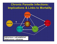
498-6033402498_57993a8b5c_m.jpgThe study,  which took place on the West Fork Smith River concluded that heavy loads of parasites can affect salmon growth, weight, size, immune function, saltwater adaptation, swimming stamina, activity level, ability to migrate and other issues. Parasites drain energy from the fish as they grow and develop.

“But we’re now getting a better appreciation that it’s the overall parasite load that is so important,”  Kent says. “The higher levels of mortality only show up with significant increases in the parasite burden.”

(Image courtesy University of Oregon)

Kent says the number of parasites affecting salmon in Oregon rivers has been increasing slowly over the years, due to warmer waters and more nutrients in the water that can be a result of logging, agriculture, inadequate bank protection and other land use changes over many years.

“Salmon can actually tolerate a fairly wide range of temperatures, it’s not just the fact a stream is warmer that’s killing them, in and of itself,” Kent says. “We now believe that some of these forces are leading to heavier parasite loads. This could be important in understanding declining salmon populations.”

Parasites that can infect salmon and other fish have complex life cycles, which could include passing through the intestinal tracts of birds that eat fish, then producing eggs that infect snails. The snails thrive in warmer water where fertilizer runoff provides them nutrients.

The salmon eat the snails, completing the cycle.

The impact of parasites on fish health was much more severe in parts of the West Fork Smith River where water moved more slowly and nearby logging and agricultural practices increased water temperature and nutrient loads. Fish in those areas had parasite infestations about 80 times higher than those higher up in the tributary.

The infections impact the salmon’s ability to survive, especially if juvenile fish are infected, that reduces their ability to survive the winter and also affects swimming ability, meaning the juvenile fish are more vulnerable to predators.

.

“Understanding why certain salmon populations are heavily infected with these parasites, which likely are driven by landscape characteristics, could help in management or recovery planning,” the scientists wrote in their conclusion, “given that our data indicates that severity of these infections are associated with survival.”

The study was done by scientists from OSU and the Oregon Cooperative Fish and Wildlife Research Unit. The corresponding author was Jayde Ferguson, a doctoral student in the OSU Department of Microbiology, and other collaborators included researchers from the OSU Department of Statistics, College of Veterinary Medicine, and Carl Schreck in the Department of Fisheries and Wildlife. The research was supported by the Oregon Department of Fish and Wildlife.The study will be published soon in the journals Aquaculture, Journal of Parasitology, and International Journal of Parasitology.

University of Oregon news release

Enhanced by Zemanta