The United States Coast Guard says the US and Canadian Coast Guards will “conduct a towing evolution using a State of Alaska Emergency Towing System” on Friday afternoon off Juneau, Alaska.
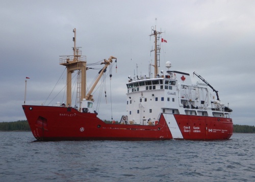
The participating vessels are the Canadian Coast Guard Marine Service Vessel and Ice Strengthened Medium Navaids Tender CCGS Bartlett and the US Coast Guard cutter USGC Maple. Like the Barlett, the Maple is also a buoy tender.
CCGS Barlett (Canadian Coast Guard)
In 2014, when the Russian vessel Simushir was adrift off Haida Gwaii, the towing system on the Canadian Coast Guard’s Gordon Reid was inadequate and the line snapped. A commercial tug was hired to take the Simushir into port at Prince Rupert. As Northwest Coast Energy News reported in October, 2014, the US Coast Guard deployed the Alaska Towing System to Haida Gwaii but it wasn’t used at that time despite a record of success by the US Coast Guard in towing vessels off Alaska waters.
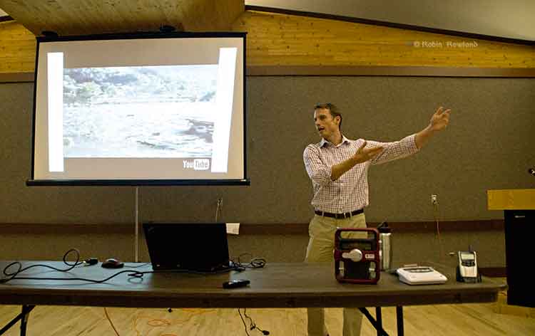
Teron Moore of Emergency Management explains a surge tsunami at a emergency preparedness forum at Riverlodge, Nov. 4, 2013 (Robin Rowland/Northwest Coast Energy News)
The District of Kitimat plans to issue a tsunami hazard and evacuation map for the town.
Fire Chief Trent Bossance and Emergency Coordinator Bob McLeod told a forum on emergency preparedness on November 4 that the map is in the final stages of preparation and will be distributed to residents in the near future.
The forum was also told that the former District Council Chambers on the second floor of the public safety building (the fire hall) is being converted into “a fixed, permanent emergency operations centre,” with upgraded communications and computer equipment.
McLeod said that over the past months, since the October 27, 2012 Haida Gwaii earthquake and the January 31, 2013, Sitka, Alaska earthquake, Kitimat’s emergency planners have been working with the province to update the original emergency plan which was first developed about 12 years ago.
McLeod said that the plan was recently sent to a consultant who told Kitimat the overall plan only needed minor charges. Now, however, there is new emphasis on tsunami planning.
Fire Chief Bossance says emergency planners have been consulting with scientists who have concluded that if a tsunami was to come into Kitimat from Douglas Channel, it most likely would be between two and four metres, so to be on the safe side, the District is planning on a “six metre baseline” from the high tide line. That means the hazard map will be based on the possibility of a six metre tsunami coming up the Channel. ( A worst case scenario, however, could result in a bigger tsunami, perhaps eight metres).
The forum at Riverlodge was part of an effort by both federal and provincial officials to visit communities that were affected by the two recent major earthquakes, inform local residents of updated planning by the federal government and British Columbia and to let those officials know what local concerns are.
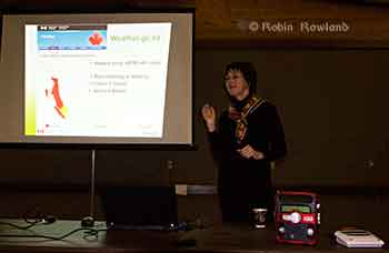
Anne McCarthy of Environment Canada explains that tsunami warnings on the Environment Canada website will be similar to weather warnings. Weather radios can be seen on the table in the foreground. (Robin Rowland/Northwest Coast Energy News)
Anne McCarthy of Environment Canada says her agency is planning to expand the Weather Radio system, most popular in Tornado Alley in the United States, to the northwest coast. There are already Weather Radio transmitters in the Lower Mainland. Kitimat, however, at this point, is low on the priority list, with Prince Rupert and then Sandspit and Masset roll outs in the coming year.
Environment Canada also plans to implement a Twitter feed sometime in 2014, that would supplement other Twitter feeds from Emergency Planning BC and the recently renamed US National Tsunami Warning Center (formerly the Alaska and West Coast Tsunami Warning Center), operated by the US National Oceanic and Atmospheric Administration. Tsunami warnings will also be posted on the Environment Canada website in the same way weather and other alerts are posted.
Surge of water
If an earthquake-triggered tsunami was to strike Kitimat from Douglas Channel, it would not be the big waves seen in the movies and during the 2004 Southeast Asia tsunamis, Teron Moore, a seismic specialist with the BC Provincial Emergency Management said. Given the configuration of Douglas Channel and its many islands, a tsunami is more likely to be a “surge” of water.
“Tsunamis can appear like a rising tide that quickly keeps coming in, “ Moore said. “A normal tide would stop at the high tide line.Sometimes a tsunami can be a quickly rising tide that keeps on coming….A wave can come in for 30 minutes. it’s a long, long time that these waves just keep on coming in and you wouldn’t see the crest of a wave, necessarily and then they come out. So it’s almost like that river comes in for half an hour and then can go back out for half an hour. There’s a tendency for people first of all to not think it’s dangerous, A second, third and fourth wave can come in.”
Tsunami events can last as much as eight to twelve hours, Moore said. Depending on the location of the triggering earthquake, Kitimat is likely to have some warning of a possible incoming earthquake-triggered tsunami.
The second type of tsunami could be triggered by a submarine landslide in Douglas Channel, as happened with slope failures in October 17, 1974 (triggering a 2.4 metre tsunami at low tide) and on April 27, 1975 (generating an 8.2 metre tsunami). The 1975 tsunami destroyed the Northland Navigation dock near Kitimat and damaged the Haisla First Nation docks at Kitamaat Village.
“The slide in 1975 generated an eight metre wave that came from Moon Bay across to Kitimat Village, now that is huge wave. We can’t really predict an event like that, it would happen so fast,” McLeod said.
Hazard areas
Two major fault lines could trigger shaking in Kitimat and might possibly also mean that there could be a tsunami.
The first is the Cascadia fault which goes from the northern California to the western edge of Vancouver Island. The second is the Queen Charlotte fault off Haida Gwaii.
The Cascadia fault, Moore said, is an active subduction zone. “A subduction zone is where two of earth’s large plates are colliding against each other and one of those plates is going under neath another one of those plates.’ The plates get stuck and build up strain “almost like pulling an elastic band. At sometime the elastic band snaps creating a very large earthquake,” Moore said.
The Juan de Fuca plate is a very large plate subducting underneath the continent of North American plate. The Juan de Fuca plate has been stuck for some 300 hundred years since the last time it ruptured. There is a rupture about every 500 years or so in this zone that triggers a large earthquake.
“But, Moore warned, “it’s 500 years plus or minus 200 years. even though there’s a lot of modelling doing on, there’s still a lot of uncertainty and so its a concept that it is difficult to get an understanding of.
“The Haida Gwaii or Queen Charlotte fault….is one that is going side by side. It’s called a strike slip fault. “A strike slip fault can still cause earthquakes it can still rupture and cause shaking, but if it doesn’t have that subduction, you tend to not have tsunamis. “Although science says the Charlotte fault has a low likely of causing a tsunami, but as we know from last year the Charlotte fault did cause a tsunami, quite a significant tsunami in some areas, not one that impacted Kitimat but one that could have impacted Kitimat and did impact, the west coast of Haida Gwaii quite significantly.
“We were very lucky there weren’t any large communities out there. We very lucky that it wasn’t at the height of summer tourist season with kayakers and fishing lodges. In some areas, the way the wave came into certain bays, created a five metre tsunami. “So if you were on the beach and a five metre tsunami was coming up the inlet, that’s a significant tsunami. What I want to emphasize is that people here who felt the shaking, they should have gone to high ground.”
Emergency procedures
In the case of a major earthquake, where residents of Kitimat feel shaking, then they should take appropriate precautions, the forum was told, including moving to higher ground if they think they should.
“Once the maps are available we will get them out to the public. I think it is important for the public to understand and visualize, where they sit within that six metre height. Always if you’re unsure go to higher ground. It’s easier to come back if your house is unaffected, than trying to leave if your house is being affected,” McLeod said.
There would be no reason to actually leave Kitimat, according to Emergency Management B.C.’s northwest regional manager Maurie Hurst. “Kitamaat Village should evacuate to higher ground. I would not like to see them coming down that coast highway to Kitimat, that’s not safe. Stay where you are, move to higher ground.
“At Sandspit higher ground is quite a ways a way from the community for them they are having to a bit of travel but in Kitimat higher ground is a ten minute walk, a five minute drive, it’s right here within the community.”
After an earthquake occurs, the National Tsunami Warning Center in Homer, Alaska evaluates the situation and sends out alerts to Canadian and US government agencies. In British Columbia, Emergency Management BC is the lead agency.
It communicates with Environment Canada, the Canadian Coast Guard, local emergency officials and the media. In Kitimat, it is the local emergency management officials and first responders who are in charge.
After misinformation went out over social media during the October 27, 2012 event, McLeod says the District of Kitimat now has social media specialists at the Emergency Operations Centre. “We’ve modified the district website, so there will be banners going up on it, just to get accurate information out.” Using the baseline of six metres above high tide, McLeod says the Rio Tinto Alcan wharfs, MK Bay Marina and the Kitamaat Village dock would most likely be affected.
While that means most of the Kitimat community may not be affected, there are other factors involved, according to Chief Bossance. “Because of all the islands we have in the waterways, we’re not going to have that big wave, we are going to have that surge,” he said. “If a tsunami is coming, we always look at the earthquake, what was its magnitude, obviously the higher the magnitude, the more impact it’s going to have for everyone in that case.
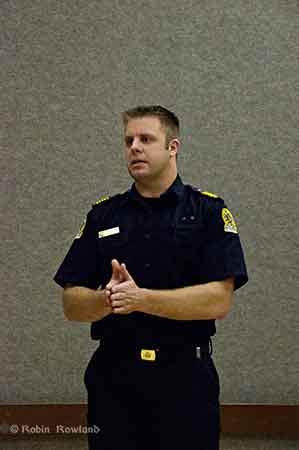
Kitimat Fire Chief Trent Bossance explains emergency procedures in case of a tsunami (Robin Rowland/Northwest Coast Energy News)
“We looked at seven point seven the most recent one, (on Haida Gwaii)it had very little impact here due the fact that it was a slip slide.
“The other fault, the one along Vancouver Island, is a different fault altogether. The problem we’re having with us right now, there haven’t been a lot studies conducted with how that waters going to impact coming from that direction into us.
“If it’s a significant shaking, don’t wait for us to tell you to go high ground.
“So they’re saying anywhere from two metres, depending on high tide up to four. We took the next step and said we’re going to go with six to build in a safety factor.
“But saying that, we have to know what our tide heights are at the time the tsunami strikes. The other thing we look at is the magnitude of the quake.
“So if you’re living down in the Kildala area and if we determine that it’s an eight metre event, then evacuation might be necessary.
“Everything is do dependent on what happens from the time of the earthquake, the tides, the weather. If we’re having significant rainfall at the time, that would mean the river would swell. If it’s the fall when we get our monsoons, that may change the fact of what’s going to happen.
“If you look at the dike, the dike is what is separating us from the river. Kitimat is sort of odd in that we have a dike that surrounds a lot of the town, but there’s an open spot in it, so it’s going to funnel through there and into the lower lying areas of the Kildala area.”
Under most circumstances, Bossance said, the City Centre Lower Parking lot would be above the danger zone.
“Just because we’re looking at six doesn’t mean it’s not going affect everyone, our plan is constantly evolving. Local officials are the ones to tell you it is safe to go back home.”
Boaters concerned
There was one question arose at the forum that the panelists had no immediate answer for. What should boaters do if there is a tsunami warning while they are on the Channel, especially during the summer or the peak salmon season when there could a hundred or so boats on the water?
“Douglas Channel is a deep channel,” Bossance said. “It’s in the shallow water and it builds, but here it is relativey deep water until it’s close to shore. That’s why it’s such a great deep sea port,its deep and then it shallows fairly quickly that’s why they’re saying we’re not going to have that big wave coming in., its going to be a surge of water.”
The panel they would investigate the situation further but at the moment they presume that it would be best to go the center of the channel. “The usually advice to make for open water that’s what the [US] coast guard recommends.”
A similar brochure from Hawaii recommends a minimum depth of 300 feet and staying clear of a harbour entrance channel during an event. The Hawaii brochure warns that if a boater is not on the water, they should not go down to their boats.
The brochure notes that: “In 1964 in Kodiak, Alaska, a warning was received prior to the arrival of the first tsunami waves. People who rushed down to the harbor to secure or take their boats out to sea constituted two thirds of all the fatalities caused by the tsunami at Kodiak City.” There is, so far, no similar brochure issued by the province of BC.
The panel suggested that a sign be posted at MK Bay, outlining safety procedures. Moore said: “The other thing we’re thinking about is there could be wave action for eight to ten to twelve hours maybe. If you need to have eight to ten hours of gas to fight the current, eight to ten hours of food, all the things you’re going to need. There were cases in California where boats kept on idle to keep being driven into shore and then they run out of gas, and then they ended up in dangerous situations. Each individual has to assess how big is their boat and where it is in the water and how it’s going to come in.
“For me I would rather be on shore if I could get to shore quick enough and get to higher ground but if you’re closer to the ocean and you have a big vessel and have the gasoline for 10 hours, then may be you’re better off.”
The Hawaii brochure also warns that watches and warnings for mariners on VHF Channel 16 (the calling and emergency channel) may be different for those on land. Hurst noted that some people in Haida Gwaii were picking up US Coast Guard advisories on VHF 16 which said the October tsunami warning had been downgraded. While the warning was downgraded for Alaska, the warnings continued for Haida Gwaii.
Hurst said those monitoring Channel 16 must be be sure they are monitoring the advisories on 16 from Prince Rupert Coast Guard Radio.
Another problem, given the configuration of Douglas Channel, is that if a tsunami severely damages MK Bay, Minette Bay, the Village Dock, the RTA docks and Nechako dock, there may be no place for boaters to return to safely given the rocky shore of Douglas Channel, which is quite different than coasts of California or Hawaii where boating is part of the emergency planning.
“The Kitimat emergency plan will have to take into consideration boaters on the water, it’s not necessarily covered by legislation but if the plan exists, they can get it out to citizens who are out on the water,” Hurst said
Preparation
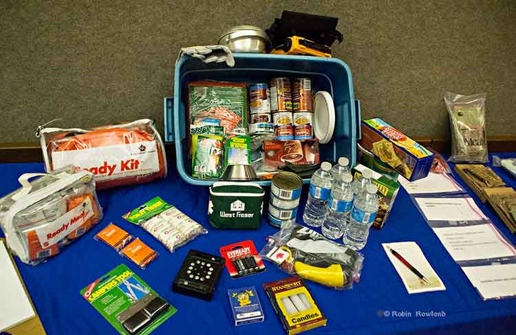
A 72-hour emergency kit was on display at Riverlodge. It includes the civilian version of military meals ready to eat as well as both dried and canned food, water, a first aid kit and other supplies. (Robin Rowland/Northwest Coast Energy News)
“From an earthquake perspective,” McLeod said, “folks should be looking at their own home preparation, making sure your residence is as earthquake proof as you could possibly make it by anchoring things to the wall, by making every effort that things are not going to fall on you. Every October there’s going to be a shakeout, which gives all an opportunity to get under the table and practice, drop, cover and hold on.
“So know the hazards, have a plan, have an emergency kit. You rotate the products in it on say an annual basis, hopefully you never have to touch it, but it’s there if you definitely need it. The emergency kit should have supplies for both humans and pets for a minimum of 72 hours.
Planning should also take in to consideration that even if there isn’t major damage in Kitimat, due emergencies in other parts of the province, the town could be cut off for several days, resulting in shortages.
Today BC Premier Christy Clark’s government outlined a series of “world leading” standards for environmental protection on the ocean and on land, if pipeline projects like the Northern Gateway and the Kinder Morgan expansion are to go ahead.
One has to wonder what Premier Clark told Prime Minister Stephen Harper when she gave him the “heads up” call on the new policy last week?
After all, the BC Liberal’s call for “world leading” standards comes just weeks after the Harper’s government, in Bill C-38, changed environmental assessment into a pro-industry process, gutted the Fisheries Act protection for habitat and severely cut back the Department of Fisheries and Oceans and Environment Canada.
So far, in the province of British Columbia, with both the governing Liberals and opposition New Democrats have been spectacularly unsuccessful in persuading the Harper government to reverse the closure of the Kitsilano Coast Guard station.
In the background paper released along with the news release on the five conditions for pipeline and tanker safety, the BC government is calling for greatly enhanced Coast Guard resources and tanker monitoring as well as payment for oil spill response.
Among the conditions for marine safety enhancement BC is asking:
Current response times and planning capacity are less stringent than other jurisdictions like Alaska and Norway. For example, for the types of tankers being proposed for Canada’s west coast, Alaska requires planning for 300,000 barrels. In Canada, response organizations are only required to maintain response plans for spills up to approximately 70,000 barrels (10,000 tonnes). Further, Alaska allows responders 72 hours to reach the spill site, while Canada allows 72 hours plus travel time, which can sometimes add days to the response.
In shared bodies of water, the United States’ requirements exceed Canada’s. For example, the United States requires escort tugs for laden tankers and mandates industry pay for designated and strategically placed emergency response tugs. Canada does not have any similar requirements.
Ensure the Canadian Coast Guard adopts a unified command/incident command structure.
The Canadian Coast Guard has a unique response system which is only used in B.C. The United States, companies and governments worldwide use a unified command/incident command response structure for a range of emergency responses, including marine spills. By bringing the Coast Guard under this system, an effective, co-ordinated response is better ensured while reducing layers of approvals that can delay critical, prompt decision-making.
At Enbridge community briefings in Kitimat last year, the company’s own marine experts said that the 72 hour response time from Vancouver and Victoria for a possible spill in the Douglas Channel was completely inadequate. In its fillings with the Joint Review Panel, Enbridge has proposed setting up and funding its own response stations along the BC coast, although so far, Enbridge has not provided any details on how the response stations would be set up and how they would work.
In 2010, the auditor general reported that Transport Canada and the Canadian Coast Guard have not used a consistent or systematic approach to tanker traffic and spills nor are there formal processes for ensuring that risks are reassessed.
Sheila Fraser found that
Procedures are not in place to verify the Canadian Coast Guard’s readiness. In other words, there is currently no process for providing assurance that the federal component of the oil spill response system is ready to respond effectively.
The Coast Guard had not conducted a comprehensive assessment of its response capacity since 2000.
The results of the Coast Guard’s response efforts—which range from identifying the source of pollution to full cleanup—are poorly documented. There are also limitations with the Coast Guard’s system for tracking oil spills and other marine pollution incidents. These gaps affect its ability to conduct reliable analysis of trends in spills and know how well it is achieving its objectives of minimizing the environmental, economic, and public safety impacts of marine pollution incidents.
In the United States Senate, Canadian Coast Guard response for an oil spill in the Strait of Juan de Fuaca was described as “call the Americans”
For some search and rescue missions the federal government has indicated that it will rely more on the all-volunteer Royal Canadian Marine Search and Rescue service (formerly the Coast Guard Auxiliary) which is already stretched thin in some areas of the Pacific Coast, rather than the full time professionals from the Coast Guard service itself.
On the industry response, BC says
The federal government should review its rules and requirements to ensure industry-funded response funds are sustainable and adequate to fully cover a major response without requiring public money. Currently, the total amount of ship owner insurance and industry funding available for spill response is $1.3 billion. By comparison, the U.S. federal government maintains a spill fund that is forecast to grow to nearly $4 billion by 2016.
Again given the government backs and the Conservative government’s close ties with the energy industry, one has to wonder what if those provisions can be enforced, especially since more and more of the energy industry in Canada is owned off shore, increasingly in China with its sorry environmental record. (Globe and MailCNOOC’s Nexen bid: A new test for Harper)
If there are to be “world-leading” standards for environmental protection in this country, it has to be paid for. So the question remains, who will pay for it? The federal government is cutting back, Alberta doesn’t want to raise the relatively small royalties it charges the energy industry and Canada is not likely to get a contribution from China.
Who pays to protect the coast and the northern interior going to be a big question for Stephen Harper in the coming months. With the polls showing Adrian Dix and the NDP leading in contention for a provincial election next year, and now with Christy Clark, apparently, demanding higher standards, will Harper open the Ottawa wallet now, will he wait until he faces a much tougher BC premier in Adrian Dix next year, or will he stubbornly hold his course of forcing Canada into his vision of a conservative, limited government nation, with, in the case of an oil spill on land or sea, that will cost the federal treasury billions, even if the energy industry picks up some of the tab?
The collision risk for the proposed tankers is assessed to be low. Therefore, the effect of implementing the traffic scheme would also be low, and the potential effect on oil spill risk very limited.
However a traffic separation scheme would make it easier for small recreational crafts in the area to keep out of the way of passing larger vessels as they would know which side the tankers would transit.
It also says:
Fishing openings in the waters of Douglas Channel and Principle Channel may affect the timing of vessel transits.
The proponent proposes to establish a Fisheries Liaison Committee that will include Aboriginal, commercial and local fisheries representatives who will provide advice on means to reduce the routine effects of the terminal operations and vessel movements on marine fisheries and other marine users. The committee will also provide a forum for discussion of measures to be taken to mitigate effects of hydrocarbon releases on other marine users.
While keeping out of supertankers is certain common sense navigation, any potential sevre restrictions are likely only to increase the irritation and opposition to the project by Kitimat and coastal boaters, fishers and environmentalists.
A report from TERMPOL for the the Joint Review Panel on Enbridge’s proposed marine operations for the Northern Gateway pipeline project, finds
While there will always be residual risk in any project, after reviewing the proponent’s studies and taking into account the proponent’s commitments, no regulatory concerns have been identified for the vessels, vessel operations, the proposed routes, navigability, other waterway users and the marine terminal operations associated with vessels supporting the Northern Gateway Project. Commitments by the proponent will help ensure safety is maintained at a level beyond the regulatory requirements.
Even though Enbridge has promised that tankers would have escort tugs, the report goes to so far as to suggest that super tankers could come and go along Douglas Channel “unassisted.”
TERMPOL has taken all the assurances from Enbridge at face value, including the use of escort tankers, and takes into consideration the company’s proposed “environmental limits (weather and sea conditions) on oil tanker navigation,” and “commitment to use industry best practices and standards.”
The report says:
The overall increase in marine traffic levels is not considered to be an issue for the shared safe use of the project’s preferred shipping routes. The proponent has also committed to including safe speeds for oil tankers and tugs in its terminal rules and requirements. It will also include safety limits for environmental and marine conditions for both vessels and terminal operations.
With the increase in shipping activity, there may be an increased threat to the well-being of marine mammal populations along the shipping route. To address this risk, the proponent has proposed measures to avoid contact with mammals. The proponent is encouraged to develop appropriate procedures to help minimize harmful effects on marine mammals.
In a news release, Enbridge welcomed the findings, quoting Janet Holder, Enbridge’s Executive Vice-President of Western Access and the senior executive with responsibility for Northern Gateway, as saying: “It is important for the public, particularly BC residents, to know that we’ve done our homework and that our marine plan has been thoroughly reviewed. I think the TERMPOL review underlines that what we are proposing is well planned and safe – and indeed would enhance safety for all shipping on BC’s north coast.”
The release says “Northern Gateway is encouraged by the positive conclusions of this technical review of the marine components of the project – including the safe operation of the Kitimat terminal and safe passage of tankers to and from the facility through Canadian waters.”
TERMPOL is an intergovernmental agency made up of officials from Transport Canada, Environment Canada, Fisheries and Oceans, Canadian Coast Guard and the Pacific Pilotage Authority. It can make recommendations and compliance with the recommendations is “voluntary.” So far companies contemplating tanker operations along the northwest coast have agreed to follow the TERMPOL recommendations.
A marine safety simulator (Enbridge Northern Gateway)
All of the conclusions depend on Enbridge’s commitment to implement and monitor practices for safer shipping for the Northern Gateway Project. “Tankers and shipping operations, like any other vessel operations, will have to comply fully with national and international regulatory frameworks. Through the proponent’s oil tanker vetting and acceptance process, ship operators will have to follow the proponent’s additional safety enhancements, which are designed to reduce the risks during operations.”
Termpol did note that with up “to 250 additional tankers per year arriving in Kitimat, there will be an impact on Transport Canada’s compliance monitoring programs.” This comes at a time the government of Stephen Harper is already drastically cutting the resources for the Department of Fisheries and Oceans and the Canadian Coast Guard on the west coast and is making across the board cutbacks at Environment Canada.
The simulations show that the largest proposed oil tankers are capable of safely navigating the entire proposed shipping route, unassisted. The route includes an S-curve where the channel widths are between 3,500 and 5,000 metres. Navigation simulations carried out by the proponent have demonstrated that a typical 320,000 tonne crude oil tanker loaded, or in ballast, can safely negotiate this area. TERMPOL report
Based on reviews by the Canadian Coast Guard and computer simulations of bridge operations, the teports says the waterways comply with all Canadian and international regulations and says:
The proposed routes provide the required clearances for good vessel manoeuvrability and allowances for very large crude oil tankers to safely navigate…
The simulations showed that tankers of the largest design are capable of navigating the entire route un-assisted. This is also consistent with opinions of Pacific Pilotage Authority Canada and the British Columbia Coast Pilots. The British Columbia Coast Pilots identified some narrow sections of the waterways as warranting caution for two-way traffic. The Canadian Coast Guard identified that the Lewis Passage-Wright Sound area warrants caution as a result of multi-directional traffic. In practice, the British Columbia Coast Pilots, supported by information from Marine Communications and Traffic Services, would adjust a vessel’s speed to avoid meeting other vessels in these areas. Transit speeds may also have to be adjusted to take into account traffic in the Wright Sound area.
TERMPOL says the “proposed shipping routes are appropriate for the oil tankers that will be used at the proposed terminal,” largely because Douglas Channel is so deep.
The next sentence says “there are no charted obstructions that would pose a safety hazard to fully loaded oil tankers,” which was pretty well known by people who sail Douglas Channel.
Testimony at the Joint Review hearings in Kitimat, presentations to District of Kitimat council and the history of the region, as related by both aboriginal and non-aboriginal sailors, show that there are concerns about dangerous storms, general heavy weather, tricky winds off the mountains and currents from the rivers meeting the ocean.
The report also says the Canadian Hydrographic Service is in the process of updating several charts of the area to ensure the most accurate information is available for safe navigation.
The report does acknowledge that there could be a tanker collision in certain areas of the British Columbia coast, saying: “The narrower passages along the North and South routes, each with charted depths of 36 m (20 fathoms) or more are all wide enough for two-way navigation by the largest design vessel,” but adds that while “the proposed channels meet the specified requirements for two-way marine traffic, the BC pilots “may choose to ensure that passing and overtaking situations do not occur in the narrowest sections, by good traffic management.”
It says that in certain areas “that the meeting of two large ships …. should, in general, be avoided, particularly during severe (wind 30 knots or above) weather conditions. The reason for this restriction is that the margins for safe navigation are limited in case of an emergency situation where the engine is lost or the rudder is locked at an angle different from ‘mid ship’.”
According to the pilots, the meeting of ships at these locations can easily be avoided through oroper planning and pilot to pilot communication and available navigation and ship tracking data.
It adds, as Enbridge has proposed, “In order to mitigate risk, all laden tankers will have a tethered escort tug throughout the Confined Channel sections (from Browning Entrance or Caamaño Sound to the Kitimat Terminal).
The report adds:
It is important to keep in mind that the emergency situations described rarely occur, but that it is necessary for the Pilots and Tug Masters to rehearse these situations on a regular basis in order to be prepared in case an incident actually occurs.
The Canadian Autoworkers Union, which represents Canadian Coast Guard radio and traffic communications staff, is urging Canadians to sign an online petition against a government decision to cut service hours at 11 of 22 Marine Communications and Traffic Services centres, and close another by the end of 2012.
One of the stations affected by the service cuts, which began on February 1, is Prince Rupert Coast Guard radio.
CAW Local 2182
CAW President Ken Lewenza held a news conference in Ottawa today which included CAW Local 2182 President Martin Grégoire and CAW Local 2182 Pacific Region Director Allan Hughes alongside NDP Opposition Critic for Fisheries and Oceans Fin Donnelly and Deputy Critic for Fisheries and Oceans Phillip Toone.
“This government has to wake up to the fact that it’s simply not worth putting Canadian lives at risk to save a few bucks,” Lewenza was quoted in a CAW news release.
“These marine communications officers are the eyes and ears of our coastal waters and play an integral part in rescue support efforts during times of crisis. Cutting these hours only creates conditions for failure.
“The federal government’s relentless push for cost savings under its national austerity program is proving reckless, especially when it directly interferes with the ability of workers to ensure the public is safe,” Lewenza said. “We cannot support these efforts and must speak out against them.”
According to the CAW, other stations affected by the service cuts are Vancouver, Victoria, Tofino, and Comox, British Columbia; Sarnia, Ontario; Quebec City and Les Escoumins, Quebec; Saint John, New Brunswick; Halifax, Nova Scotia; and St. John’s, Newfoundland.
The CAW represents 350 marine communications and traffic services officers across Canada.
On February 1, the day the service cuts took effect, Fisheries Minister Keith Ashfield issued his own news release, saying the union statements until that time were “misleading.”
Ashfield said:
“The safety of Mariners is our top priority and we would not implement any policies that would put lives at risk.
“As a result of a risk assessment and workload study, in which the CAW participated, the Coast Guard is reducing the number of overtime hours for employees at Marine Communications and Traffic Services Centre to reflect the actual workload at any given time.
“While the union tries to portray this as shortsighted, the fact is that this approach has already been in use successfully in Victoria and Quebec for about 5 and 10 years respectively and the Coast Guard is simply now expanding this approach on a national level.
“There will be no jobs lost as a result of the implementation and mariners will continue to receive the same level of service they currently receive.
“Like any responsible organization, we must ensure that we use our resources wisely. Canadians do not want to be paying for unnecessary or unproductive overtime.”
Fisheries Minister Keith Ashfield late Wednesday issued a statement calling objections by the CAW to an overtime ban at Coast Guard radio, “misleading.”
The safety of Mariners is our top priority and we would not implement any policies that would put lives at risk.
As a result of a risk assessment and workload study, in which the CAW participated, the Coast Guard is reducing the number of overtime hours for employees at Marine Communications and Traffic Services Centre to reflect the actual workload at any given time.
While the union tries to portray this as shortsighted, the fact is that this approach has already been in use successfully in Victoria and Quebec for about 5 and 10 years respectively and the Coast Guard is simply now expanding this approach on a national level.
There will be no jobs lost as a result of the implementation and mariners will continue to receive the same level of service they currently receive.
Like any responsible organization, we must ensure that we use our resources wisely. Canadians do not want to be paying for unnecessary or unproductive overtime.
The Coasta Cruise line Sunday issued a statement about the sinking of the liner Costa Concordia, which ran around off the island Giglio, near Tuscany, Italy on Friday. There were 4,200 passengers and crew on board when the ship hit a rock or reef, was beached and later sank on its side. Five bodies have been recovered, three people have been rescued from the hulk and 17 people are still listed as missing.
The statement emphasizes the lines safety record, training and safety precautions, then implicates the captain, Francesco Schettino, with “significant human errors.” It says Schettino had first joined the company in 2002 as a safety officer.
An earlier statement, issued Saturday, said the ship follows the same route “52 times a year.”
Sunday statement 2015 hrs Central European Time
We at Costa Cruises are deeply saddened by this tragedy, and our hearts and prayers go out to everyone affected and offer the determined victims’ families her heartfelt condolences.
Over the past 48 hours, more than 1,100 Costa employees have been working tirelessly in the wake of this terrible event. We are working closely with the authorities to support ongoing search and rescue operations, and are focusing on ensuring that all guests and crewmembers return home safely.
Our immediate priority is to account for all passengers and crew and to secure the vessel to ensure that there are no environmental impacts. We have engaged the services of a worldwide leader specialized salvage company to develop an action plan and help establish a protection perimeter around the ship. It should be noted that the Prosecutor in charge has seized the ship and the DVR– so called “black box” containing all navigation data and the vessel can be accessed by Costa only with permission from the authorities.
We are working with investigators to find out precisely what went wrong aboard the Costa Concordia. While the investigation is ongoing, preliminary indications are that there may have been significant human error on the part of the ship’s Master, Captain Francesco Schettino, which resulted in these grave consequences. The route of the vessel appears to have been too close to the shore, and the Captain’s judgment in handling the emergency appears to have not followed standard Costa procedures. We are aware that the lead Prosecutor has levelled serious accusations against the ship’s Captain, who joined Costa Crociere in 2002 as a Safety Officer and was appointed Captain in 2006, after acting as Staff Captain as well. As all Costa Masters, he has been constantly trained passing all tests. In light of these accusations and the continuing investigation, it would be inappropriate for us to comment further at this time.
As we are learning more about the event itself and the evacuation, however, it is becoming clear that the crew of the Costa Concordia acted bravely and swiftly to help evacuate more than 4,000 individuals during a very challenging situation. We are very grateful for all they have done.
Costa is committed to ensuring that no such incident ever occurs again. Our number one priority is always the safety and security of our guests and crew and we comply with all safety regulations. (See background on Costa safety below).
Background on Costa’s commitment to safety
Costa complies very strictly with all safety regulations and our personnel are committed, first and foremost, to guest safety and security.
All crew members hold a BST (Basic Safety Training) certificate and are trained and prepared to emergency management and to assist passengers abandoning the ship with numerous drills. Roles, responsibilities and duties are clearly assigned to all crew members. Every two weeks all crewmembers perform a ship evacuation simulation. A lifeboat and evacuation drill for all guests is conducted within 24 hours of embarking, as required by law. Costa has a computerised system which ensures all passengers undergo this drill.
The skills of Costa crew are periodically tested by Coastguard authorities and an independent classification organization as per SMS (Safety Management Systems) requirements.
There are lifeboats and jackets on board in excess of the number required for all passengers and crew. Lifeboats are equipped with food and water supplies, first aid kits and communication and signalling equipment. All life-saving appliances are aligned to international standards and are subject to close, regular inspection by shipboard personnel and certification authorities. All Costa ships are certified by RINA and have been built to the highest standards and technologies.
Saturday statements
1730 CET
“I want to express our deep sorrow for this terrible tragedy that devastates us” – said Gianni Onorato President Costa Crociere – “I am here only now because, as you will understand, I have been from the down until now on the Isola del Giglio to be close to the rescue operations.
First at all, I would like to thank all the authorities, law enforcement and volunteers who made all efforts to help and assist our Guests involved in this terrible event.”
We are not at this time able to provide an answer to all the questions, because the competent authority are trying with our cooperative efforts to understand the reasons for this incident.
On the basis of the first evidences, still preliminary the ship Costa Concordia under the command of the Master Francesco Schettino was regularly sailing from Civitavecchia to Savona, when suddenly the ship stroked a rock.
The Master who was on the bridge at that time, understood the severity of the situation immediately performed a maneuver aimed to secure Guests and crew, and started the security procedures in order to prepare for an eventual ship evacuation.
Unfortunately, this operation was complicated as result of a sudden tilt of the ship that has made difficult the disembarkation.
Thanks to the commitment of all forces coordinated by the Coast Guard, from that moment on, rescue operations have been further strengthened.
From the first time the company mobilized all its resources ashore to put in to assist our guests and crew members and prevent possible environmental impacts.
1200 CET
The Costa Concordia accident happened tonight it’s a tragedy that deeply shocked our company.
Our first thought goes to the victims and we would like to express our deepest condolences to their families and friends.
We’re close to the people who have been injured and we’re following their progress.
All our efforts are now concentrated in assisting the guests and the crew who were on board, to bring them home as soon as possible.
The Costa Cruises customer service has already started contacting by phone all the guests who were supposed to board today in Savona and starting from tomorrow in the scheduled ports.
At the moment no changes have been planned to the schedule of the other Costa Cruises ships.
People looking for assistance can contact the call centre number 08453510552.
All the Costa Cruises people would like to thank from the deepest of their hearts the Guardia Costiera, the authorities and the citizens of the Giglio Island and of Porto Santo Stefano who helped and assisted the guests and the crew.
They also thank the doctors who are assisting the injured and anyone in need of assistance.
The Company is cooperating with the Authorities that are investigating on the accident.
0500 CET
It is a tragedy that deeply affects our company. Our first thoughts go to the victims and we would like to express our condolences and our closeness to their families and friends. In this moment all our efforts are focused on the completion of the last emergency operations, besides providing assistance to the guests and the crew who were onboard in order to have them going back home as soon as possible. The emergency procedures started promptly to evacuate the ship. The slope, gradually taken over by the ship, made the evacuation extremely difficult. We would like to express our profound gratitude to the Coast Guard and all the forces co-ordinated by the Coast Guard, including the authorities and citizens of the island “Isola del Giglio”, who have been involved in the rescue and assistance to guests and crew members. The company will fully co-operate with the relevant Authorities in order to determine the causes of what happened.
0100 CET
Costa Cruises confirms the evacuation of about 3,200 passengers and 1,000 crew members on board of the Costa Concordia. An incident occured near the island ‘Isola del Giglio’ of the coast of Italy. The evacuation started promptly, but the position of the ship has worsened, making it more complicated to complete the last part of the evacuation. At this moment, the cause of the incident cannot yet be confirmed. The Company is currently working with the highest commitment to provide all the needed assistance. The Costa Concordia was sailing across the Mediterranean Sea, starting from Civitavecchia with scheduled calls to Savona, Marseille, Barcelona, Palma de Mallorca, Cagliari and Palermo. About 1.000 passengers of Italian nationality were onboard, as well as more of 500 Germans, about 160 French and about 1.000 crew members.
The Guests had to embark today in Savona and in subsequent ports will be contacted directly by Costa Cruises.
Scientists from the University of California at Davis and NOAA studying herring spawning beds in San Francisco Bay after the Costco Busan oil spill. (UC Davis)
A 53,569 gallon (202,780 litre) spill of bunker oil in San Francisco Bay in 2007 had an “unexpected lethal impact on embryonic fish,” according to scientists from the University of California at Davis and the US National Oceanic and Atmospheric Administration who spent two years on follow-up research after the spill, looking at the effects of the spill on Pacific herring.
One significant finding from the study is that different oil compounds, for example crude or bunker oil, likely have different effects on vulnerable environments.
On November 7, 2007, the container ship Cosco Busan hit the San Francisco-Oakland Bay bridge, breaching two fuel tanks and sending the bunker oil into the bay. Television images of the accident were seen around the world.
Damage to the Cosco Busan. ( PO 3 Melissa Hauck/US Coast Guard)
The oil spill polluted the nearby North Central Bay shoreline spawning and rearing habitat for herring, described by the study as “the largest coastal population of Pacific herring along the Continental United States.” The spill happened a month before the herring spawning season.
The herring from the estuaries of San Francisco Bay migrate in large schools up the Pacific Coast to the Bering sea, and are food for whales, other mammals, salmon and birds. After two years at sea they return to the spawning grounds.
The study also notes: “Herring are a keystone species in the pelagic food web and this population supports the last commercial finfish fishery in San Francisco Bay.” It adds: “Although visibly oiled shorelines were cleaned, some extensively, only 52% of the oil was recovered from surface waters and land or lost to evaporation. The amount of hidden or subsurface oil that may have remained near herring spawning areas is unknown.”
The study, Unexpectedly high mortality in Pacific herring embryos exposed to the 2007 Cosco Busan oil spill in San Francisco Bay, was published Monday, Dec. 26, in the journal Proceedings of the National Academy of Sciences.
The study suggests that even small oil spills can have a large impact on marine life. Gary Cherr, director of the UC Davis Bodega Marine Laboratory and lead author of the study says, “Our research represents a change in the paradigm for oil spill research and detecting oil spill effects in an urbanized estuary.”
That’s because the study builds on research following the 1989 Exxon Valdez disaster in Prince William Sound, Alaska, which released 32 million gallons (121 million litres) of crude. The Exxon Valdez spill also happened close to the herring spawning season and studies since then have shown mortality and abnormalities in the fish in Prince William Sound.
The San Francisco study shows that the bunker oil accumulated in naturally spawned herring embryos. At low tide, the oil then interacted with sunlight in the shallower regions of the estuary, killing the embryos. A control group of herring, fertilized in a laboratory and place in cages in deeper water, were protected from the combination of oil and sunlight but still showed “less severe” abnormalities.
“Based on our previous understanding of the effects of oil on embryonic fish, we didn’t think there was enough oil from the Cosco Busan spill to cause this much damage,” Cherr said. “We didn’t expect that the ultraviolet light would dramatically increase toxicity in the actual environment, as might observe in controlled laboratory experiments.”
One reason may be that crude oil, the kind spilled by the Exxon Valdez, is naturally occurring liquid petroleum. Bunker oil is a thick fuel oil distilled from crude oil and used as a fuel on ships. Bunker oil can be contaminated by other, unknown substances. In the case of the Cosco Busan, the bunker oil was relatively low in sulfur compared to some other bunker fuels but the embryos showed higher than expected levels of sulfur compounds.
Scientists from the University of California at Davis and NOAA studying herring spawning beds in San Francisco Bay after the Costco Busan oil spill. (UC Davis)
The scientists analyzed the levels of oil-based compounds in the caged herring embryos at four oiled and two-non oiled sub tidal sites, all at least one metre below the surface. Naturally spawned embryos from shallower areas were also studied.
In November, 2007, the spilled oil was visible in the areas chosen for the study. By the time the herring eggs were incubating, oil was not visible in the contaminated areas, except for some tar balls found on shore.
The researchers began the study in February 2008 . At the time, three months after the spill, the caged embryos showed non lethal heart defects, typical of exposure to oil spills. The embryos in the shallower sub tidal zones showed the same heart defects but also had “surprisingly high rates of dead tissue and mortality unrelated to the heart defects.”
“The embryos were literally falling apart with high rates of mortality,” Cherr said.
Normal herring embryos are translucent and colourless when they hatch, except for the pigment around the eye and melanophores (pigment cells) along the gut. The the brain, spinal cord and axial muscle from embryos from the oiled sites were not as clear. Those embryos had no heart beat and the skin tissue was disintegrating.
No toxicity was found in embryos in unoiled sites, even those close to major highways. The researchers concluded that the high death rates did not seem to be caused by natural or man made causes unrelated to the spill.
In 2009, when the scientists concentrated on the role of sunlight, the study showed that the embryos had death rates characterized by loss of tissue similar to the embryos from the year before, but possibly caused by undetected compounds from the oil spill.
In 2010, the scientists again looked at embryos from the oiled and unoiled sites. By that time, the hatching rates from the oiled sites were similar to the “relatively high hatching rates” for the unoiled areas. However, there was a “significant incidence” of heart problems among embryos from the oiled sites.
The scientists conclude that while the Exxon Valdez spill did show oil poisoning fish in the early stages of life, they say case wider research is needed beyond that done for in the case of the Exxon Valdez because the Cosco Busan
1. Highlights the difference in effects on fish from exposure to oil of differing composition (i.e. Crude vs bunker)
2. Shows the role of sunlight, interacting with local conditions (such as shallow water) can have significant affects on toxicity.
3. Shows the need for more study of the toxic effects of different oil compounds
4. The study has shown the “exceptional vulnerability of fish early stages to spilled oil.”
The conclusion adds “Although bunker oil typically accounts for only a small fraction of oil in ships, so spills may be small relative to those of crude oil, it may carry a potential for disproportionate impacts of in ecologically sensitive areas.”
Both Ellis Ross, Chief Counsellor of the Haisla Nation and April McLeod, president of the Kitimat Valley Naturalists expressed concern abut the findings of the study, especially with the Joint Review Hearings on the Enbridge Northern Gateway pipeline scheduled to begin a few days.
The numerous environmental critics of the Northern Gateway pipeline have pointed out that there is no way of knowing what would happen to an area like the Kitimat River, estuary and Douglas Channel is there was a bitumen spill. Enbridge has filed documents with the Joint Review Panel that include simulations of a spill. The new San Francisco study shows that any oil spill could have unforeseen effects.
Plans call for at least three new terminals to be built close to the Kitimat River estuary, not just the controversial Enbridge terminal for bitumen, but at least two for the liquified natural gas projects, KM LNG and BC LNG and in all three cases ships would normally be fueled by bunker oil.
The Kitimat estuary has been industrialized for 60 years since the building of the Rio Tinto Alcan smelter, but still has large areas teeming with fish and wildlife, so the estuary is somewhat in the middle between the heavily urbanized estuaries of San Francisco Bay and the more pristine Prince William Sound.
Ross pointed to the collapse of the oolichan in the Kitimat River as a strong indicator of potential problems. He recalls that in the early stages of the Eurocan paper mill the Haisla Nation was told there would be no effect on the oolichan, but soon after the mill began operations, the oolichan population collapsed. That is why, Ross said, the Haisla are wary of the plans and want to see more and stronger studies done on the effects of bitumen and other oil compounds in the region.
Other comments were unavailable due to the holiday. They will added as received.
Kitimat River estuary on Dec. 17, 2011, showing a Rio Tinto Alcan transmission tower. (Robin Rowland/Northwest Coast Energy News)
According to Wikipedia, the US National Transportation Board found that the Cosco Busan accident was caused by
the pilot’s degraded cognitive performance from his use of prescription medications, despite his completely clean post accident drug test,
the absence of a comprehensive pre-departure master/pilot exchange and a lack of effective communication between Pilot John Cota and Master Mao Cai Sun during the accident voyage, and
(COSCO Busan Master) Sun’s ineffective oversight of Cota’s piloting performance and the vessel’s progress.
Other contributing factors included:
the failure of Fleet Management Ltd. to train the COSCO Busan crewmembers (which led to such acts of gross negligence as the bow lookout eating breakfast in the galley instead of being on watch) and Fleet Management’s failure to ensure that the crew understood and complied with the company’s safety management system;
the failure of Caltrans to maintain foghorns on the bridge which were silent despite the heavy fog;
the failure of Vessel Traffic Safety (VTS) to alert Cota and Sun that they were headed for the tower. VTS is legally required to alert a vessel if an accident appears imminent, yet they remained silent;
the malfunctioning radar on the COSCO Busan, which led Captains Cota and Sun to use an electronic chart for the rest of the voyage. Although Coast Guard investigators found the radar to be in working order, they did not examine it until days after the accident (allowing time for faulty equipment to be fixed, which is not uncommon after a marine accident)
Captain Sun’s incorrect identification of symbols on the electronic chart;
the U.S. Coast Guard’s failure to provide adequate medical oversight of Cota, in view of the medical and medication information he had reported to the Coast Guard.
Employees of the federal Department of Fisheries and Oceans were told Wednesday their employer will soon be significantly smaller, and responsible for fewer things.
DFO also warned its workers that some of them will definitely not be working there once the department completes a $56.8-million budget-cutting plan by 2014.
“More savings are expected in the future,” said a letter signed by Deputy Minister Claire Dansereau and two other top officials.
The letter and supporting documents, which were obtained by CBC News, say reductions are part of a “dynamic change agenda,” and will apply broadly to services that include the Canadian Coast Guard.