Can Kitimat’s historic CN railway station be saved from demolition?

Analysis    (Long Read)

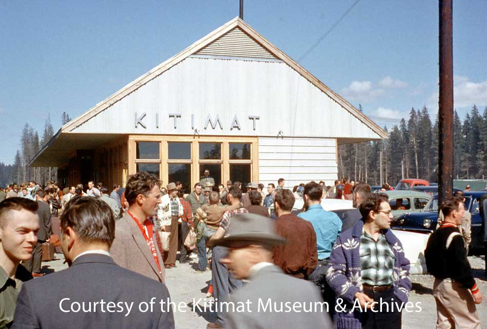
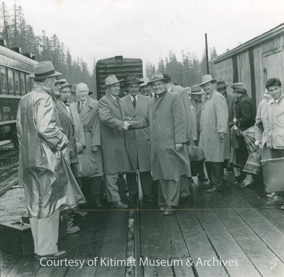
A crowd gathers at the Kitimat CN Station sometime in 1955. This picture may be of the station opening since the windows and trim are unpainted. (Walter Turkenburg/Kitimat Museum & Archives. ) See Note 1.

UPDATE There  will be a public meeting to discuss the future of the station in Kitimat on Thursday,  April 11, 2019 at Riverlodge, in the Activity Room, at 7:30 pm.

March 12: This story has been updated to clarify that Kitimat Heritage has not yet discussed municipal, provincial or federal heritage status with CN. Also more information about CN telegraph communications has been added.

Kitimat Heritage and supporters in the community are campaigning to save the town’s old Canadian National Railway Station. Kitimat Heritage wants to preserve the station because it is symbolic of the earliest days of the townsite when Kitimat was first being built and celebrated as the 1950s “town of the future.”

District of Kitimat Council voted Monday February 25 to send a letter of support to CN and to take other appropriate measures to support an effort to save the old CN Railway Station in the Service Centre.

Retiring Member of Parliament Nathan Cullen (NDP Bulkley Valley) is also working at the federal level to get help to preserve the station. The provincial MLA Ellis Ross (Liberal Skeena) has promised he will work at the provincial level.

Louise Avery and Walter Thorne make a presentation to District of Kitimat Council on the future of the CN Station on February 25, 2019. (Robin Rowland)

Local historian Walter Thorne and Executive Director of the Kitimat Museum & Archives Louise Avery presented a package to council that gave the history of the station and the current state of negotiations with CN. (Disclosure I am chair of the museum board but not directly involved in the campaign. The opinions in this article are strictly my own and may not reflect the views of Kitimat Heritage or the museum)

There have been two architectural assessments of the railway station. The first by John Goritsas on behalf of the Kitimat Museum & Archives in 1992 and this year on behalf of Kitimat Heritage by Prince Rupert architect Alora Griffin.

While the station overall is in “desperate condition” it appears from both assessments that the core of the station is, as far as can be determined, structurally sound.

A close view of the station in 2014, showing the “desperate condition.” (Robin Rowland)

The station, built in 1955, has been in poor repair for years.  According to Kitimat Heritage CN  has said it  sees no other clear alternative than to demolish the station given its run-down nature, the potential liability issues, and the revenue potential of the land.

If CN  did want to demolish the station ,  it can’t at the moment because it is protected by both municipal and provincial heritage status. So far the question of heritage status has not yet come up in the discussions.

District of Kitimat Council first passed a bylaw giving the station heritage status in September 1985.The municipal heritage status of the station is part of the official Kitimat Community Plan, adopted by council in 2008.

The railway stations in Prince Rupert and Smithers are designated under the federal Heritage Railway Stations Act.

Only designated heritage railway stations that are still owned by a railway company under federal jurisdiction are subject to the nationwide Heritage Railway Stations Protection Act. Under the act no railway company may in any way alter, demolish, or transfer ownership of a designated heritage railway station without the authorization of the federal cabinet.

In the case of Kitimat, the Heritage Group has not yet officially asked CN to support designation.

CN officials, speaking to the heritage volunteers, have told them that the station is an “eyesore” and there is “revenue potential” from the station site as Kitimat gears up for the building of the LNG Canada plant and other projects including a proposed propane terminal.

The CN Station in 2012. (Robin Rowland)

Railway stations as brands

To understand what makes the Kitimat station unique, you have to know about the history of railway station construction in North America.

From the mid-nineteenth century until the First World War, a time when railways were the prime form of transportation, railway stations were designed to both attract paying passengers and to promote the railway brand. The railways hired the leading architects of the day to design metropolitan stations in grand style, often neo Classical like Toronto’s Union Station or Grand Central in New York or “Romanesque” such as Union Station in Nashville, Tennessee (now a Marriot Hotel) that resembles the style of Canada’s Parliament Buildings.

Montreal’s Windsor Station, once the headquarters for Canadian Pacific was also built in a Romanesque style.

See Time Magazine’s selection of the world’s ten most beautiful railway stations  and Fodor’s travel has a list of what it believes to be the world’s 20 most beautiful main line stations .

The same care in architectural design and construction was applied to even the smallest railway stations in those early years—although many were based on same designs from stop to stop.

When the Grand Trunk Pacific was building the line to Prince Rupert a century ago the GT built iconic smaller stations (designated by the Plan Number 100-152) along the route, with fourteen in the Smithers subdivision, including at Tyee, Kitwanga and Kwinitsa. (See Vanishing BC Grand Trunk Pacific Stations)

The latter station is now part of the Kwinitsa Station Railway Museum & Park in Prince Rupert.

The Prince Rupert station built in 1921 is an example of a utilitarian brick box that has federal protection.

The designation says the Prince Rupert Station is an example is “significant as a very early example of a public building in the Modern Classical style. Executed in brick and trimmed with Tyndall limestone, the station design combines traditional composition with simple, stripped-down classical detailing.”

The Smithers Station is considered more special it is an important and rare example of the custom-designed “special stations” built by the Grand Trunk Pacific Railway (GTP) at several divisional points along its transcontinental line. This small group of specially designed stations represented a departure from the GTP’s overall policy of rigid standardization in depot design. (like the ones at Tyee, Kwinitsa and Kitwanga)

End of an Era

That era of great railway stations ended in 1929 with the Great Depression when commerce largely collapsed. Railways in North America had little money to spend on grand passenger stations. Then came the Second World War when the priority for the railways was supporting the war effort.

Railway historians say that after 1945 most spending for North American railways was to replace aging  steam locomotives with new diesel locomotives. The railways also had to retire old rolling stock such as boxcars that had been kept in service during the war.

That meant even in the post war decade from 1945 to 1955 constructing new stations was not a priority. Those stations that were built, mostly in the United States, replaced buildings that were no longer usable. Most were “modern” brick boxes based on a utilitarian design that reached back to the 1920s or the newer “brutalist” buildings of mostly poured concrete.

Kitimat was a different case—there was a brand new branch line from Terrace.  That meant Kitimat needed a railway station.

The architects who assessed the Kitimat station say it is an example of the modernist “form follows function” style of architecture popularized by Frank Lloyd Wright. The load bearing 2 x 6 trusses align the exterior walls which was one of Wright’s innovative ideas.

The station was designed by CN staff. The 1992 architect, John Goritos, said, “it was designed to suit the site and wasn’t a replica of any of other CN railway stations.”

The architects say that one reason the Kitimat Station was built of wood was not only that it had to be constructed quickly but the light weight was suited to the site which was on the Kitimat River flood plain filled in with sandy landfill.

Building the Kitimat branch line

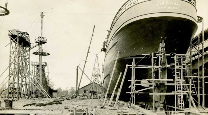
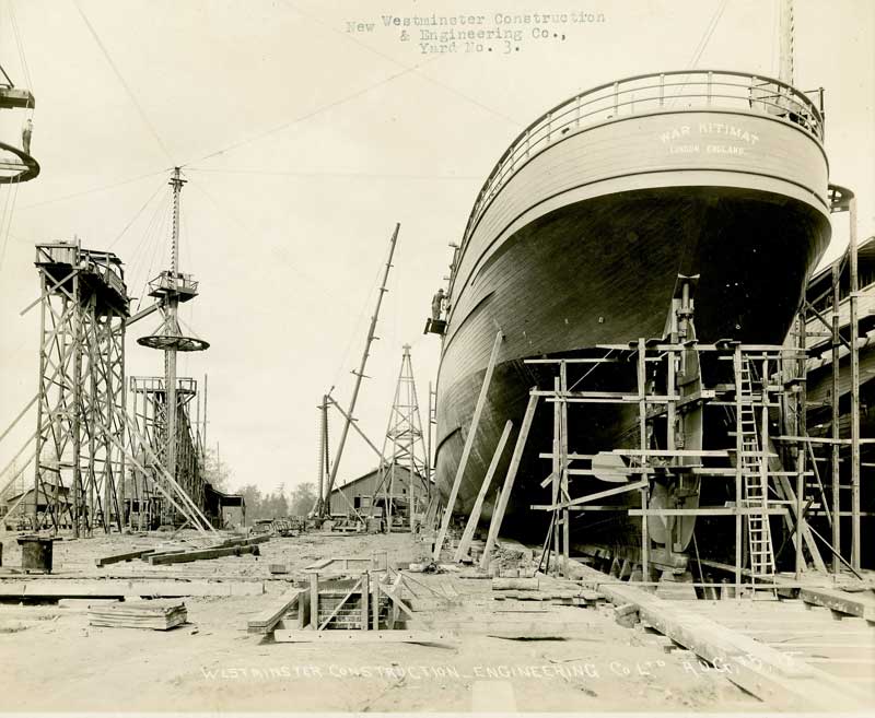
As Alcan was planning and building Kitimat, the company signed transportation contracts with CN. That was the reason the branch line was built to the townsite, then past the sandhill to the aluminum smelter.

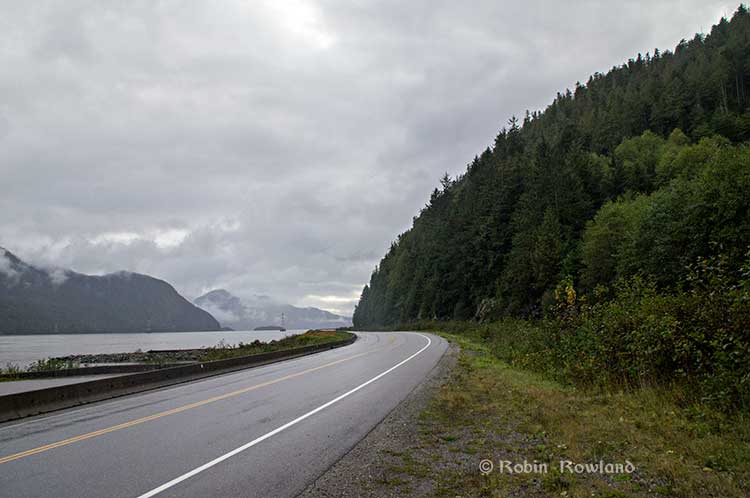
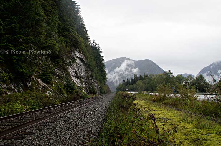
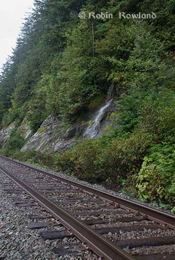
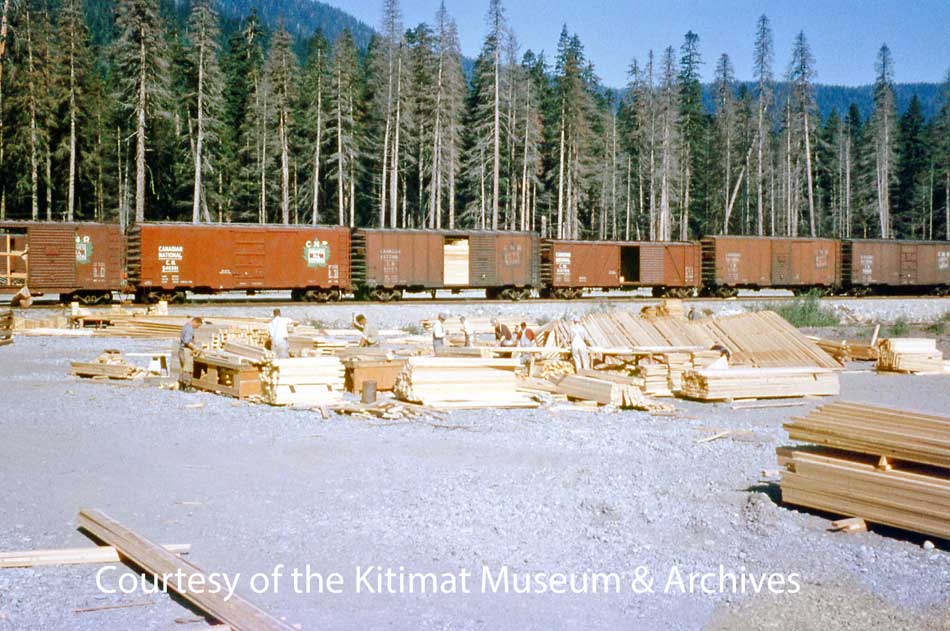
CN worked to build the new branch line for 38.5 miles crossing “difficult terrain of the area, including swamps, hard clay, rocks and watersheds.’ The route included three steel Pratt triangular truss bridges over the Lakelse, Wedeene, Little Wedeene Rivers and plus a number of smaller old fashioned traditional wooden trestles over creeks.

Canadian Transportation magazine reported in July 1952 that the branch line alone would cost $10 million 1952 dollars or $217,391.30 per mile.

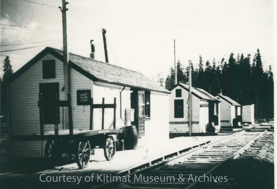
Freight travel began as soon as the branch line was completed in December 1954. Temporary huts acted as the train station when passenger service began in January 1955 but were soon overwhelmed.

It was CN practice to use huts (and sometimes a retired boxcar) to act as a temporary station until a new one was built. (Mrs. L Byron collection/Kitimat Museum & Archives)

Former Kitimat mayor Joanne Monaghan who worked at the station recalls that once the Alcan plant became operational although most of the ingots were shipped out by sea, there were long trains outbound with car after car loaded with aluminum ingots.

The British news magazine The Sphere published a photograph of the first passenger train to arrive in Kitimat in February 1955,

The British magazine The Sphere (an equivalent of Life or Look) covered the story this way in a report on Feb. 19, 1955.

“In the far north-west of Canada new trains have just started to run along a new railway. The line starts in a small town called Terrace and its only forty-three miles long. But its importance is out of all proportion to its length for the new terminus is in Kitimat, the new wonder aluminum manufacturing of the Canadian Aluminum Company (sic).”

The anonymous reporter photographed what The Sphere said was the arrival of the first passenger train in Kitimat. The locomotive was Canadian National steam locomotive 2129, a 2-8-0 “Consolidation” that had been in service since 1911 with three railways, the Canadian Northern and the Duluth, Winnipeg and Pacific ( a CN subsidiary in the United States) before being transferred to CN. The loco hauled three passenger coaches and two boxcars on that initial run from Terrace. Note 2.

A Northern Sentinel photo taken a little later than the Sphere photo, showing the “:twice weekly train” in Kitimat, February 1955, before the new station was built. (Northern Sentinel/Kitimat Museum & Archives)

The 2-8-0 was a heavy-duty locomotive designed for hauling freight. All those outbound boxcars filled with ingots and, inbound, as the town was being built, boxcar after boxcar filled with lumber to build the houses and stores of the brand-new town.

Building a town of 8,000 almost overnight required whole CN trains filled with lumber (Walter Turkenburg/ Kitimat Museum & Archives)

The “milk-run” train also serviced Lakelse Lake (where there was a whistle stop in a clearing by the tracks, which I remember from a vacation at Lakesle in the summer of 1957) as well as “stations” (again really just clearings) on the timetable at Wedeene, Dubois, Lakelse and Thunderbird, to pick up loggers, surveyors, fishers and hunters. The trip from Lakelse to Kitimat would have taken one hour and thirty minutes if the train was running on schedule.

Once dedicated passenger service began, CN assigned another steam locomotive, a lighter 4-6-2 Pacific, Number 5000, built in 1913.

As CN was transitioning to diesel, it assigned its last remaining steam locomotives to more remote parts of Canada, like northwest BC.  The Pacific, Number 5000, was retired in May 1958. The 2-8-0 Consolidation Number 2129 was scrapped in May 1960.

RELATED: The Kitimat branch line operating trestle bridges
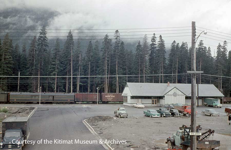
The station

CN put the station construction out to tender in June 55. The building was completed by the Skeena Construction Company, based in Terrace, before the end of the year.

Dignitaries welcome the first daily train to arrive in Kitimat on June 2,1955 . (Northern Sentinel/Kitimat Museum & Archives)

Train was the main mode of travel between Terrace and Kitimat from December 1954 until November 1957 when the highway to Terrace was opened.

Freight operations continued to use the depot for years after passenger traffic ended.

Like many branch line railway stations in North America, the Kitimat station combined passenger and some freight and express operations (most of the freight operations were carried on down the line to Kitimat Concrete Products at the sandhill and on to the Alcan smelter.)

There was soon a lot of traffic in those days people coming in from all over the world to find work. News reports at the time said the three-hour train journey from Kitimat to Terrace was so popular that there was often “standing room only” in the passenger cars.

An undated aerial shot of the Kitimat CN Station and the service centre. A train with six carriages is stopped at the station. (Max Patzelt Collection/Kitimat Museum & Archives)

The trains expanded from a single passenger car to three and later several as demand grew.

The station had a large interior large waiting area with washrooms, a “restroom” and later a small coffee and snack bar was added to the waiting room.

Along a corridor were the depot office and the combined telegraph office and what was called the “repeater room.” Off the corridor were also the station keeper room and conductors’ office. There was a typical bay window operator’s room in the waiting area that looked out onto the tracks.

On the freight side were the express office and the “on hand” (goods for pick up). The original plans had had one door in on the east wall and one door out by the tracks on the west side. Two doors on the north wall added later to meet demand.

A shot of the Kitimat station in the 1950s. (David Wade Collection/Kitimat Museum & Archives)

CBC Radio

On the blue prints for the station there is what is today a cryptic reference to the Telegraph-Repeater room which is the part of the building where we see the Canadian National Logo today. The role of the telegraph – more likely teletype by the 1950s—is obvious. The telegraph office operated for many years after passenger service ended.

It turns out the “repeater” was the first transmitter for CBC Radio in Kitimat. Canadian National Telegraphs operated most non-telephone communications in Canada along its railway lines.

CN had actually had some of the first radio stations in Canada, which were later taken over by the CBC when the Parliament created the public broadcaster.

So, in the Kitimat Station there was a LPRT or a Low Power Relay Transmitter. The  “radio” signal came into Kitimat via a CN landline for broadcast. The LPRT was designed to be sited in a location were there was no other coverage or before an actual transmitter was built.

The railway company domination of telecommunications continued in 1967 when CN and CP telegraph services merged to form CNCP telecommunications. That company was later sold to Rogers when the railways got out of the telecommunications business they had founded in the previous century.

Some smaller locations across Canada still have CBC LPRTs where it is not economic to build a transmitter. Today the signal is downlinked from satellite.

CN and the station were also the conduit for secure government communications, including the RCMP.  It also transmitted the Canadian Press wire service.   Later BC Tel (now Telus) took over many of those functions.

End of passenger service

CN stopped passenger rail service to Kitimat in November 1957 almost as soon as then Highway 25 to Terrace was completed, although the station was still used to coordinate freight and express operations for a few years after that.

In the 1960s, passenger traffic on railways across North America plummeted as the era of the car and air travel became more the normal way to go.

CN used the station for storage in the 1970s and let it deteriorate and at one point it was vandalized. It was briefly owned by the District of Kitimat, but ownership has since reverted to CN.

Today’s train stations were most often just glass and steel, if there were stations at all. Many new stations are glass covered platforms with perhaps a small ticket office (and if passengers are lucky, washrooms).

The Kitimat CN Station is a unique snap shot of Canadian railway architecture and construction from the mid 50s that wasn’t duplicated.

CN has boarded up the building and says it is an “eyesore” and has told the heritage group that it is not structurally sound and should be moved from the site or be demolished.

Architectural assessments

The two architects reported that the station is a one story 3500 square foot structure supported by 2 x 6 fir trusses and 2 x 4 stud walls set in concrete slab. The roof trusses appear to be made of red cedar. As far as both architects could tell (access was somewhat limited) both the fir and reds cedar have survived the previous 62 years largely intact.

The roof was made of aluminum shingles, which were popular at the time as part of what was called “machine age allure” of the “space age” Streamline Moderne and “Googie” forms of architecture. The aluminum shingles, as well as the flashing were well suited for Kitimat because aluminum aged well, and snow would slide off an aluminum roof easier than traditional asphalt shingles.

The problem with the roof is that the sheathing between the red cedar and the aluminum has warped over the decades and that has displaced or heaved most of the aluminum shingles. The fascia will also have to be replaced.
The station hasn’t been heated or properly maintained for many years. That means apart from the structural walls, the rest mostly plywood and plasterboard has deteriorated markedly.

Asbestos

The greatest mistake—in retrospect—and the greatest challenge is the widespread use of asbestos in the building.

It appears that the CN architects and structural engineers in 1955 who designed the station wanted to add to that “machine age allure” by using the “modern” asbestos cladding. Before that almost all the smaller Grand Trunk and CN stations in western Canada had stucco on the exterior walls. In retrospect if CN had stuck with stucco, the station would—allowing for the poor maintenance– probably be in better shape. There are houses in Kitimat with stucco walls that have survived the elements for 50 to 60 years. If the walls were stucco, there would not be today’s cost of removing asbestos.

The asbestos cladding or siding is seen on the CN station, March 6, 2019. (Robin Rowland)

The most obvious use of asbestos is in the cladding or siding on the walls of the station which was a popular material up until the 1980s when the cancer risk from asbestos was realized. In the parts of the station which had linoleum floor—the passenger and office areas—it is likely that linoleum from that era contained asbestos. There is bare concrete floor for baggage express storage and heater rooms, so those are areas where there is presumably no asbestos in the flooring.

Asbestos was also wrapped around many of the building’s mechanical infrastructure and heating ducts. The soffit under the eaves may also contain asbestos.

There is so much asbestos that even if CN wanted to demolish the station the company couldn’t just bring in a backhoe or bulldozer and pull it apart as is done some other cases were there is no asbestos.

Under BC law, the asbestos would have to be safely removed by an asbestos qualified removal company before a demolition permit can be issued.

Renovating also requires a BC qualified asbestos abatement contractor.
In both cases, there has to be a hazardous material survey prior to any work commences.  During the work—whether demolition or renovation—there has to be continuous hazardous material and air quality monitoring in the area. (Noting that the station is close to the Kitimat Hotel and service centre businesses)

It appears that CN hasn’t really bothered to undertake a detailed cost benefit analysis. The question is how much cost difference would there be in safely removing the asbestos prior to demolition and the cost of safely removing the asbestos prior to restoration?

Another question that has to be ironed out is who is responsible for the asbestos. CN owns the building and is currently responsible. If, as originally proposed, CN sold the building to the Kitimat Heritage for one dollar, the heritage group would then be responsible. If the heritage group gets to lease the building from CN, then CN, as the landlord, is likely still responsible for the upkeep of the building—a cost that CN apparently, at present, doesn’t want to undertake.

Worksafe BC must be notified of any project where asbestos is being removed (ws0303-pdf-en) PDF

Links
Province of British Columbia
Management of Waste Asbestos 
Worksafe BC Asbestos 

Stay or go? And if go, where?

Kitimat faces two choices with the station. To keep it on the current site or to move it elsewhere.

At present, according to the report by Kitimat Heritage presented to District of Kitimat Council, CN would like the building moved away from a potential revenue producing area along the right-of-way.

The Kitimat Heritage group wants the station to remain in place as the role as a train station is part of the Kitimat’s history. As the report says, “The building is not heritage without its provenance—the rail line.”

Both architect Alora Griffin and some building experts say it cannot be moved because the original design placed the load bearing trusses on the concrete pad foundation and therefore there is no floor that would support the station if it was to be moved.

That raises another question, which the far away CN executives have probably never considered because they appear to be clearly unfamiliar with Kitimat infrastructure is where would an intact station be moved to?

The bottle neck would be the Kitimat River/Haisla Boulevard bridge which was built back in 1954, a bridge that urgently requires a seismic upgrade at very least and should be replaced if it is to sustain loads of trucks heading the LNG Canada construction site.

The current District limits for crossing the bridge call for a height restriction of four metres. The maximum clearance on the bridge is 4.2 metres or 13 feet nine inches in height. The maximum weight is 65,000 kilograms or 143,000 pounds. The station is just over nine metres or 29 feet high, which means the station would never fit onto the Haisla Bridge. So why move the station from its current location?

The Haisla Boulevard Kitimat River Bridge seen on March 6, 2019. It is likely impossible to move the station via the bridge to the main Kitimat townsite. If a moving company did attempt the job, all those wires would have to be removed or moved. (Robin Rowland)

If a contractor found a way to move across the Haisla Bridge, however unlikely, by splitting up the building, costs of moving such a building are determined by the size of the building, what work has to be done to the building prior to moving, the distance moved and incidentals such as working with BC Hydro and telecom companies if overhead wires are in the way, cutting down trees if necessary, traffic control or traffic restrictions and other problems a moving company might run into.

So far, no company has been involved that specializes in moving large structures, including heritage structures.

The average minimum cost of moving a residential house in the United States can be $16 a square foot or more, so the minimum cost of moving the 3,500 square foot station—if the sound parts of the structure can actually be moved—would probably begin at least $60,000. Actual costs are usually much higher.

The bridge restrictions mean that the station would have to remain in the service centre anyway.

So why move it?

Another possibility that was raised by local contractors is dismantling the structure, numbering the salvageable parts such as trusses, beams and roof supports and reconstructing the building elsewhere. . One factor is how the trusses would be removed from the concrete base and rebuilt elsewhere in Kitimat.

That latter solution, however, is considered by many to be cost prohibitive. That evaluation would have to be made a qualified restoration architect. A check of available records shows that many–not all– of the  CN stations that have been moved are in the prairie provinces where logistics are much easier.

Restoring the station

Kitimat Heritage is asking that the funds CN would have to spend in any case to demolish the building instead be put toward restoration.

The aim of the heritage group is to convert it into a community meeting space, perhaps with a restaurant and a small museum or other guide to Kitimat Heritage.

The heritage group wants a land lease from CN, but the company says a lease at present is impossible due to liability issues. CN has told the heritage group that if was to lease the building it would want $5,000 per year in rent, a $50,000 letter of credit and $10 million in liability insurance.

CN, as the present owner of the station, is, of course, currently solely responsible for any current liability issues that may occur.

CN has told the heritage group that it doesn’t entertain land sales within 100 feet of its right-of-way which is why the railway wants the station moved if it is sold (but as noted above there is no where for the station to go). That is why the heritage group wants a lease.

There are dozens of heritage railway stations across Canada that are still owned by CN and thus have federal protection. (see Note Three below for the list of CN Stations).

It is unlikely that preserving the Kitimat Station would have any adverse effect on CN’s bottom line. In 2018, CN had revenues of $14.321 billion and an operating income of $5.493 billion. The annual report says the railway carried $250 billion worth of goods in 2018 over 20,000 route miles in Canada and the United States. CN buildings were worth $1.186 billion in 2018, according to the report.  The Kitimat Station is still on the CN books (and accounting for depreciation as reported in the annual report) and is a miniscule asset.

If an agreement is reached with CN, then the heritage group would have to embark on a fund-raising effort. The next step would be to hire an architect, either a local architect or one who specializes in heritage restoration.

The building would also have to be brought up to current seismic standards and meet the current British Columbia building code for public buildings.
To bring it up to code an architect would have to redesign building and coordinate with electrical, mechanical and structural engineers. Structural engineer would have to asses the condition of the trusses and other parts of the building for possible defects and possible needed upgrades.

To restore the building the customary procedure is to ask three local contractors for a realistic estimate of the cost (not a low bid bid). To be sure, the heritage group should also ask for a bid for a contractor who specializes in restoration. A restoration specialist would likely identify hidden costs or unexpected savings.

What’s next?

The heritage group wants to come to an agreement with CN before proceeding to ask the community for financial and volunteer support.

Although the discussion between the heritage group and CN have been fruitful so far, it appears from CN’s insistence that the station be moved that the company has not bothered to fully research either the heritage of the Kitimat Station nor the geography and geology of Kitimat.

If CN had done a thorough appraisal of the situation, they would know that it is unlikely that the station could cross the Haisla Bridge and thus should stay in situ.

The proposed Pacific Traverse Energy propane project would greatly add to the rail traffic in the area –and also add to CN’s revenue. There are two proposed sites for a rail staging yard, one about three kilometres north of the service centre on Crown Land and the second on Rio Tinto owned track close to the station location—which is probably what CN means when it says the site has “revenue potential.” The current estimate is that the project would require 60 tank cars each day to service an export terminal near Bish Cove.

So far,  only pure rumour and speculation have said that the propane project is an impediment to saving the station.

At some point the company should be invited to join the discussion. Since Pacific Traverse Energy has said in its presentation to council that the company is going to embark on a “rigorous program of community engagement” this year and that it is committed to “economic, social, cultural and economical sustainability.” Emphasizing the word cultural means that the company could prove its commitment to the community of Kitimat by taking into consideration the future of the CN Station in any planning and decisions on land use or by helping to pay for station restoration of out a budget of $400 million while ensuring the safety of the station area if the project proceeds.

The cost of restoring the station is likely to be substantial and not only government but corporate funding as well as in kind contributions from local contractors and businesses will be needed to fully restore the station and make it operational as a community centre.

One factor is that the railway line from Terrace and the train station were built by CN on behalf of the then Aluminum Company of Canada, a company that promised CN back in the 50s at least a million dollars a year in revenue. (According to the Bank of Canada inflation calculator one million dollars in 1950 would be 11 million dollars in 2019—which may nor may not reflect how much Rio Tinto actually pays CN). It’s clear that both CN and Rio Tinto have profited from the rail line for the past almost 70 years and it’s time that some of those profits were applied to preserving Kitimat’s heritage.

Kitimat factory town or more?

Most railway heritage buildings and heritage railways around the world are maintained and operated by volunteers usually railway buffs, heritage activists and retired railway employees.  There are few, if any, railway employees retired in Kitimat (although there may be some in Terrace or Prince Rupert). This could prove a problem in Kitimat where the same small group of volunteers are engaged in multiple efforts while others in the community seldom contribute. On the other hand, the restoration of the station and its operation as a community meeting place could bring out new volunteers.

The old CN Station on March 6, 2019. (Robin Rowland)

The bigger picture that Kitimat has to decide on is what kind of town will this be in the future?

Back in the nineteenth century, when those iconic railway stations were built across North America, many mining, smelting and logging towns built equally impressive “opera houses” or other culture landmarks that are still preserved today.

While Kitimat never had a grand opera house, there is the station that marks the town’s early settler history.

The LNG Canada final investment decision approval and the growth of Asian markets for hydrocarbon energy (at least for the next few decades) and quality aluminum, means that the industrial base of Kitimat is assured.

Tourism has always been a low priority and culture has been an almost a zero priority.

So, is Kitimat going to be just an industrial town or is it Kitimat going to be more than that with cultural amenities for its residents and to be more than a tourist draw for mostly aging recreational fishers?

Whatever decision is made on the CN station will help decide the road to that future.

LINK

Kitimat Museum & Archives contact page.

Note 1.

A small boy is seen in the photograph of the station wearing a “coonskin cap.”  The Disney TV series Davy Crockett was broadcast from December 1954 to February 1955.  Two follow up movies starring Fess Parker were Davy Crockett, King of the Wild Frontier, 1955, and Davy Crockett and the River Pirates, 1956. Disney heavily marketed the coonskin cap to small boys, selling at one point 5,000 a day in the United States. Most were made of faux fur.   Although Kitimat did not have television until years later, the cap likely dates the photo to the summer or fall of 1955, the height of the coonskin cap craze.  Wikipedia.

Note 2

CP 2-8-0 3716 at Kettle Valley. (Canadian Model Railroads/Wikipedia)

You can see a Canadian Pacific 2-8-0 steam locomotive similar to the CN loco that made the first trip to Kitimat at the Kettle Valley Steam Railway in Summerland.

Note 3

A list of Canadian National (or affiliate) heritage railway stations protected by the federal government. This list does not include stations owned by VIA Rail, Canadian Pacific or smaller Canadian Railways.  There should be no reason that Kitimat’s station cannot join this list. (The George Little House station in Terrace was not originally a railway station but a heritage house that was moved to the trackside as a VIA station)


British Columbia
Kamloops
Kelowna
McBride
Prince Rupert
Smithers
Vancouver
Alberta
Jasper
Saskatchewan
Biggar
Humboldt
Melville
Moose Jaw
North Battleford
Manitoba
Churchill
Dauphin
Gillam
McCreary
Neepewa
Portage la Prairie
Rivers
Roblin
The Pas
Ontario
Alexandria
Barrie
Auroa
Belleville
Brampton
Brantford
Casselman
Chatham
Cobourg
Comber
Ernestown
Fort Frances
Galt/Cambridge
Georgetown
Guelph
Hamilton
Hornepayne
Kingston
Kitchener
Leamington
Maple
Markham
Nakina
Newmarket
Niagara Falls
North Bay
Orillia
Owen Sound
Parry Sound
Port Hope
Prescott
Sioux Lookout
St. Thomas
Stratford
Toronto Union Station
Woodstock
Quebec
Amqui
Clova
Joliette
Macamic
Matapédia
Mont-Joli
Montréal
New Carlisle
Port Daniel
Saint-Hyacinthe
Saint-Pascal
Sainte-Anne-de-la-Pérade
Sayabec
Senneterre
Shawinigan
Sherbrooke
New Brunswick
Edmunston
Grand Falls
Sackville
Sussex
Nova Scotia
Amherst

Kitimat’s unknown role in the First World War

Ninety-seven years ago, long before the main townsite was founded in the 1950s, (the Haisla Nation, of course, had been here for thousands of years) Kitimat was to play a short, now forgotten and unlucky role in the First World War with the launch of a vessel in New Westminster called the  War Kitimat as one of the many emergency new ships commissioned by the British government to replace vessels lost to Germany’s unrestricted submarine warfare that was sinking convoys taking vital supplies across the Atlantic.

During the First World War, over nine million gross tons of British ships were lost due to enemy action, both submarines and surface raiders. The worst losses came in the three months ending June 1917 when over 1.4 million gross tons were sunk.

In December, 1916, the Prime Minister David  Lloyd George’s British Government appointed a “shipping controller” to manage a worldwide shipbuilding program to replace the lost vessels, to be built quickly, efficiently and to a series of standard designs. Although the vessels were often different, they were called “standard ships.” It was the Great War’s equivalent of the Liberty Ships built during the Second World War.

Many of the orders were placed with Canadian companies, others with the Japanese shipyards and British owned or controlled shipyards in Hong Kong and Shanghai. Canada created or contracted 19 emergency shipbuilders which built 137 cargo ships and 15 trawler/minesweepers. Some of these yards were purpose-built, others were repair yards that were converted to construction yards; seven were in BC, nine were in Ontario and Quebec, and three were in the Maritimes.

Orders were also placed with shipyards in the United States, but when the Americans entered the war in 1917, those ships were requisitioned by the U.S. Government.

All the ships’ names were given the prefix “War” no matter where they were built in the world.

The Canadians built both steel hulled and wooden hulled cargo vessels, including the War Kitimat, as well as yachts and sailing yachts (which likely became the war time “trawlers”). The British built 12 different types of “dry cargo” vessels, five types of “coasters” plus tankers.  The United States also built wooden hulled cargo vessels (slightly larger than the Canadian versions) and various types of steel hull cargo ships.

The government of France also contracted Canadian shipyards for its own vessel building program.

In Canada, the BC Marine Railway Company was one of the prime contractors, and the job of building four ships was awarded to the New Westminster Shipbuilding & Engineering on Poplar Island, which can be seen today from New West’s Esplanade at Westminster Quay.

The First Nations of the area had used the island for generations and in 1871 the island was designated an Indian Reserve. During the small pox epidemic of 1889, with many members of the Vancouver area First Nations struck down by the disease, a hospital was built on the island. It is believed that many of those who died of smallpox were buried there. Because of the association with disease and death the island was abandoned until 1917, when the war time necessity meant a shipyard was built on the island.

The War Kitimat under construction in New Westminster (Canadian War Museum)

New Westminster Shipbuilding had the job of constructing four “war” class wooden hulled freighters, 2300 gross tonnes, 3300 dead weight tonnes, 250 feet long with a beam of 43.5 feet, with 322 nominal horse power triple reciprocating steam engines powered by two water tube boilers, turning a single screw capable of ten knots.

The company built four ships, the War Comox, War Edensaw, War Kitimat and War Ewen. The War Comox was first launched in April, 1918, but completion was held up as the shipyard waited for equipment from suppliers. That led to pressure to build, launch and complete the War Edensaw, which was launched in June 1918, and the War Kitimat, which was launched on  Sunday, August 18, 1918.

The War Kitimat immediately ran into trouble. According to the Times Colonist, right after launch the War Kitimat ran aground off New Westminster and had to be lifted off the Fraser  river bed by using jacks until was raised enough so that tugs could attach lines and tow it to deep water.  About a week later, the War Kitimat was  towed to Victoria for repairs and further fitting out (possibly to the Foundation Company shipyard which was also building five of the war class vessels. Foundation is now Seaspan’s Point Hope Marine)

The War Kitimat did make at least one voyage to Great Britain, but by the time it arrived, the war was coming to a close. After the Armistice on November 11, 1918, the ships were no longer needed and the British government sold most of them to shipping companies. (All the ships were UK registry, not Canadian)

Flag for Lloyd Belge line
Flag for Lloyd  RoyalBelge line

In 1919, the War Kitimat was sold to the Lloyd Royal Belge S.A. line of Antwerp, Belgium and renamed the Serbier.

On January 12, 1920, the Serbier, on a  voyage from Cartagena and Oran to Antwerp with zinc ore and general cargo on board, sprang a leak in her engine room during a “raging gale” in the Bay of Biscay and sank  80 nautical miles (150 km) off Penmarc’h, Finistère, France at 47°38′N 6°10′W. Her Capt. A. Canfrère and the crew were rescued by the French ship SS Docteur Pierre Benoit.

How the ship came to be named War Kitimat isn’t certain. It was probably named after the Kitimat River since other vessels in the War category were named Skeena, Stikine, Babine, Niagara, Ottawa (others were named for cities like Halifax or Toronto).

The Belgian shipping company did not give up on the name Serbier. It purchased another US-built War cargo ship, first named the War Hound by the British. After the US entered WWI in 1917 and took over the building there it became the Lake Huron, a US Navy Transportation Service mine carrier. From later in 1920, Royal Belge operated the new Serbier until 1924, when it passed through French, Norwegian, Danish and then as the Advance,  Finnish ownership. The Advance was seized in Panama by the United States in 1941 and renamed the Trojan. After the Second World War, the US returned the ship to Finland. It sailed as the Advance until it was sold a Greek shipping company in 1965 and scrapped at Piraeus in 1966.

Of the ships under British control, 821 ships were ordered by the UK shipping board and 416 were completed. Fourteen were lost to enemy action. The remaining orders were cancelled but often completed by the shipyards.

Many of the “war” or “standard” ships passed through various owners.

During the Second World War many played their original role and took part in the convoys that crossed the Atlantic.  Many were sunk during those crossings. Others, sold to growing Japanese shipping interests in the 1920s and 1930s, were sunk by US destroyers and submarines. Others like the War Hound /Serbier survived to the 1950s and 1960s.

Of the War Kitimat’s sister ships built in New Westminster, the War Comox was sold to an Italian company, renamed the Guidatta and scrapped at Genoa in 1925, The War Ewen was sold to a German company, renamed the Etienne Marcel and scrapped in Germany in 1925. The War Edensaw, under the original name, was carrying Admiralty stores from Constantinople to Malta,  when it caught fire on June 25, 1919 and sank 94 nautical miles east of the St. Elmo Lighthouse on Malta.

As for Poplar Island, it was zoned for industrial use but no one could come up with ideas for how to use the island.   New Westminster sold the island to Rayonier Canada in 1945, where it became an anchorage for log booms on the Fraser River. The successor company, Western Forest Products sold it back to New Westminster in 1995,  The island is still a wilderness area in the middle of urban Vancouver and subject to treaty and land claims negotiations with the area’s First Nations.

Related links
Poplar Island: A History as Thick and Colorful as the Trees

Emergency Shipbuilders of World War I

World War One Standard Built Ships

World War One Standard Built Ships (this is a different site to the one above)

Vessels Built by B.C. Marine Railway Co

The Ship’s List (database of ships, link is to Lloyd Royal Belege entry)


Editor’s Note:   Up until now Kitimat has not had a reason, unlike other communities, to mark Canada’s role in the First World War.  We suggest that should the District of Kitimat choose to do so either this year or in the next three years, August 18, the date of the launch of the War Kitimat might be an appropriate date, in addition to Remembrance Day on November 11.

Mongolia to hold text message referendum on future of Rio Tinto copper mine

Rio TintoMongolia will hold a reality television style text message referendum on the future of Rio Tinto’s troubled Oyu Tolgoi copper mine project, the Financial Times reports.

The FT says Mongolian prime minister Saikhanbileg Chimed will ask voters whether their country should develop more of its mineral resources or resort to austerity to support the faltering economy.

Mongolian voters will have four days, beginning Saturday, to text their vote on the future of Rio Tinto’s plans for the  $6 billion project.

Oyu Tolgoi
Shaft at the Rio Tinto Oyu Tolgoi copper and gold mine in the southern Gobi, Mongolia (Brücke-Osteuropa via Wikipedia)

Economists say the copper mine project, which is stalled because Rio Tinto has been unable to reach an agreement with Mongolia over project financing and revenue sharing could generate about a third of the country’s gross domestic product. The lack of an agreement, in concert with current instabilty on financial markets has sent Mongolia’s currency plunging.

Like Kitimat’s plebiscite on the Northern Gateway, the vote will be non-binding. The FT says the vote “could help Mr Saikhanbileg broker a consensus in favour of allowing OT to proceed, cutting through the arguments of critics who say Mongolia is not getting its fair share of the mine’s earnings.”

The FT reports: “The prime minister, who explained the referendum this week on television, was trying to appeal to the general public ‘over the heads of squabbling factions in parliament and break the logjam.'”

Full story at Mongolia holds text message vote on mining v austerity
(registration required)

Aussie energy company eyeing Apache stake in Kitimat: media reports

The Australian Business Review is reporting that Woodside Petroleum, a cash rich Australian energy company, has its eye on Apache’s 50 per cent stake in the Kitimat LNG project. As part of any deal, Woodside would probably also have to buy Apache’s stake in the Australian Wheatstone LNG project, which is also up for sale.

The months-long process by Apache to find a new home for its West Australian domestic gas business and its stake in the under-construction Wheatstone LNG project — as well as its stake in the Kitimat LNG project in Canada — has drawn plenty of interest from parties in that neck of the woods.

The cashed-up, project-hungry Woodside Petroleum has been interested from the outset in the Kitimat stake, but is also said to be prepared to make an offer on Wheatstone if Apache is determined to sell the assets together


WoodsideEarlier,  another Australian newspaper, The Age reported that Woodside’s petroleum and LNG operations had “revenue of $US5.3 billion for the first nine months of 2014. Compared with the corresponding period in 2013, revenue was 28.7 per cent higher for the 2014 period.”Part of the money came from selling natural gas assets in the United States.

According to The Age:

Woodside’s LNG production rose to a record 5.1 million tonnes for the first nine months of Woodside’s fiscal 2014. The record production represents a rise of 17.6 per cent on the same period for 2013. Behind the result was the operational performance of the Pluto LNG facility (Woodside’s interest is 90 per cent). Pluto lifted LNG production by 24.3 per cent on the corresponding period in 2013, to 3.1 million tonnes. Pluto also produced 2.2 million barrels of condensate for the first nine months of 2014. Oil production rose by a mammoth 33.3 per cent on the same period in 2013, to 8.8 million barrels.

On November 6, according to the Sydney Morning Herald, Woodside’s CEO Peter Coleman warned that the Asian customers for LNG who are holding out for cheaper prices could face a  “supply crunch” and “By holding out for a cheaper price, customers are potentially exacerbating project FID [final investment decision] delays and may unwittingly help bring on a supply crunch.”

He called on suppliers and customers to work together to  ensure supply projects went ahead.

The Woodside website describes the company as  “Australia’s largest independent dedicated oil and gas company and one of the world’s leading producers of liquefied natural gas.​​​​​​”

It goes on to say

As we aspire to become a global leader in upstream oil and gas, we are guided by the Woodside Compass. The Compass links Woodside’s core values – respect, integrity, working sustainably, working together, discipline and excellence – with our vision, mission and strategic direction.

Woodside has an extensive portfolio of facilities which we operate on behalf of some of the world’s major oil and gas companies.
We have been operating the landmark Australian project, the North West Shelf, since 1984 and it remains one of the world’s premier liquefied natural gas (LNG) facilities.

With the successful start-up of the Pluto LNG Plant in 2012, Woodside now operates six of the seven LNG processing trains in Australia.

Sending the Northern Gateway Pipeline to Prince Rupert: A dumb, dumb, dumb idea—and here are the photos to prove it.

There’s a dumb, dumb, really dumb idea that just won’t go away—that Enbridge could solve all its problems if only, if only, it would send the Northern Gateway Pipeline to Prince Rupert.

Enbridge long ago rejected the idea. Before Enbridge updated its website to make  Gateway Facts, to make it slick and more attractive, the old website had an FAQ where Enbridge explained why it wasn’t going to Prince Rupert.

Did you consider running the pipeline to Prince Rupert where a major port already exists?

We considered Prince Rupert and Kitimat as possible locations. We carried out a feasibility study that took into account a number of considerations. The study found that the routes to Prince Rupert were too steep to safely run the pipeline, and that Kitimat was the best and safest option available.

Current proposed route for the Northern Gateway pipeline. (Enbridge)

Here in the northwest even the supporters of the Northern Gateway roll their eyes when they hear the old Prince Rupert story come up again and again – and it’s not just because these people support the Kitimat plans for Northern Gateway, it’s because those supporters (not to mention the opponents) have driven along the Skeena from Terrace to Prince Rupert.

There just isn’t any room for a pipeline. It’s a game of centimetres.

A rainbow hugs the mountains near the Telegraph Point rest area on the Skeena River between Terrace and Prince Rupert, Sept. 29, 2014.  Traffic is seen on the narrow corridor between the mountains and the river (Robin Rowland/Northwest Coast Energy News)
A rainbow hugs the mountains near the Telegraph Point rest area on the Skeena River between Terrace and Prince Rupert, Sept. 29, 2014. Traffic is seen on the narrow corridor between the mountains and the river (Robin Rowland/Northwest Coast Energy News)

Alternatives to Kitimat?

Now the new premier of Alberta, Jim Prentice, who should know better if he’s going to lead that province, is hinting that Kitimat isn’t the only possible solution for the Northern Gateway.

Without specifying Prince Rupert, according to Gary Mason reporting in The Globe and Mail, Prentice was speculating about an alternative to Kitimat.

Asked whether he believes the Gateway terminus should be relocated to Prince Rupert or another destination, Mr. Prentice said, “Everything I’ve heard from the Haisla who live there is they don’t agree with the terminal being in Kitimat.” Is it possible to get First Nations approval if there is no support at the planned terminus site? “It’s pretty tough,” the Premier said.

A couple of days ago, the Prince Rupert’s Mayor Jack Mussallem told The Globe and Mail in Mayor, port authority say no room for Northern Gateway pipeline in Prince Rupert

Prince Rupert has a thriving local fishing industry that employs hundreds of people and is critically important to the local First Nations. He is convinced the community would not be willing to put that at risk.
“Overwhelmingly people in my community are much more comfortable with liquefied natural gas, with wood pellets, with coal, than any oil product,” he said.

The Prince Rupert Port Authority also rejected the idea

A spokesman for the Prince Rupert Port Authority said Wednesday there is currently no room for Enbridge to build at the port even if it wanted to. “We are fully subscribed,” Michael Gurney said. There are two large vacant lots within the port authority’s jurisdiction, but both are locked by other energy companies, earmarked for LNG projects.

So not only is there no room on the road to Prince Rupert, there is no room in Prince Rupert.

Shovel-ready?

Let’s just consider for a moment that if Prince Rupert was the ideal location for the Northern Gateway terminal (which it is not), what would be needed to get the project going today.

The Northern Gateway Joint Review Panel would have be reconstituted or a new JRP created by the National Energy Board. That’s because the bitumen comes from Bruderheim, Alberta, crossing provincial boundaries and thus it’s in federal jurisdiction.

Even under the fast track rules imposed on the NEB by Stephen Harper’s Conservative government, new environmental and social impact studies would be required, starting from scratch. So add another five years of paperwork before a single shovel goes into the ground.

The pipeline would have to cross the traditional territory of First Nations that, so far, have not been part of the negotiations, mostly the Tsimshian First Nation as well as the Nisga’a First Nation which has a treaty establishing local rule over their territory.

Traditional leaders of the Gitga'at First Nation lead a protest march through the streets of Prince Rupert, February 4, 2012. (Robin Rowland/Northwest Coast Energy News)
Traditional leaders of the Gitga’at First Nation lead a protest march through the streets of Prince Rupert, February 4, 2012. (Robin Rowland/Northwest Coast Energy News)

In February 2012, the largest anti-Enbridge demonstration outside of the Lower Mainland took place in Prince Rupert, with the elders of the Tsimshian First Nation welcoming the elders and members of the Gitga’at First Nation, at Hartley Bay, which had organized the protest.

While Kitimat Council long stood neutral on the issue, the councils at Prince Rupert, Terrace, Smithers as well as the Kitimat Stikine Regional District and the Skeena Queen Charlotte Regional District had voted to oppose the Northern Gateway.

Audio Slideshow; No to Tankers Rally, Prince Rupert, February 4, 2012

The Skeena Route

The Skeena is one of the greatest salmon rivers on the planet. The Petronas LNG project has already run into problems because its planned terminal at Lelu Island would also impact the crucial eel-grass which is the nursery for young salmon leaving the Skeena and preparing to enter the ocean. Note that northern BC is generally in favour of LNG terminals, if the terminals are in the right place, so expect huge protests against any bitumen terminal at the mouth of the Skeena.

When I say there isn’t room for a pipeline along the Skeena, it also means that there isn’t any room for the pipeline corridor right-of-way. Enbridge, in its submissions to the Joint Review Panel, said it requires a 25 metre wide right of way for the pipeline corridor. (For the record that’s just over 82 feet).

Along that highway, as you will see, there’s barely enough room for the CN mainline and Highway 16 (also known as the Yellowhead Highway) and on a lot of places both the highway and the railway roadbed are built on fill along the side of a cliff.

Now I’ve said this all before, two years ago, in a piece for the Huffington Post, Get Over it! A Pipeline to Prince Rupert Is Bust

Albertans’ desperate desire to see the Northern Gateway go to anywhere to what they call “tide water” keeps coming up like the proverbial bad penny. The latest came when Jim Prentice speculated about a new route for the Northern Gateway.

I knew I had an appointment coming up in Prince Rupert on Monday, September 29. So I decided that only way to prove to people sitting in Calgary, Edmonton and Fort McMurray playing with Google Maps that the pipeline to Prince Rupert was a really dumb idea was to shoot photographs to show just why the Northern Gateway will never go to Prince Rupert—at least along the Skeena.

As you drive out of Terrace, you pass two large swing gates (also called by some “Checkpoint Charlie” gates after the Cold War era crossing in Berlin.) At the first rest stop west of Terrace, there are another set of gates at the Exstew. There’s a third set of gates just outside Prince Rupert.

A logging truck passes the avalanche gates at Exstew on Highway 16, Sept. 29, 2014.  (Robin Rowland)
A logging truck passes the avalanche gates at Exstew on Highway 16, Sept. 29, 2014. (Robin Rowland)

The swing gates are avalanche gates and, in the winter, Highway 16 can be shut down if an avalanche closes the highway or the danger from avalanche is too great to allow motorists to proceed. When you drive the highway from Terrace to Prince Rupert in the winter (the signs were covered up when I drove Monday) you are warned “Avalanche danger Next 13 kilometres. No stopping.”

The Exstew avalanche gates, (Robin Rowland/Northwest Coast Energy News)

The drive along the Skeena from just west of Exchamsiks River Provincial Park all the way to Tyee where the highway turns inland to reach northwest to Prince Rupert on Kaien Island is one of the most spectacular drives on this planet. The highway snakes along a narrow strip of land with steep mountain cliffs on one side and the vast river on the other.

The problem is that apart from locals and tourists, none of the “experts” whether journalist, think tanker, bureaucrat or politician have, apparently ever driven from Prince Rupert to Terrace.

When both Opposition Leader Tom Mulcair and Liberal Leader Justin Trudeau were in the northwest earlier this summer to “engage” with the local people, apart from short boat trips down Douglas Channel, they flew everywhere. Scheduling you know. Stephen Harper has never visited northwest BC and probably never intends to. His cabinet members fly in for photo ops and then are on the next plane out of town.

Of all the visiting journalists who have come to the northwest only a couple have bothered to drive around the region. Most fly-in fly-out. These days, most often budget-strapped reporters never leave their offices, interviewing the same usual suspects by phone on every story.

On Monday, I took most of the photographs on my way back from Prince Rupert to Terrace after my appointment, so the sequence is from west to east. There are also very few places along the river where you can safely stop. There are concrete barricades on both sides of the highway to prevent vehicles either going into the river or onto the narrow CN right-of-way.

There are, however, two rest stops and a number of small turnoffs on the highway, the turnoffs mainly intended for use by BC Highways, but which are also used by tourists, fishers and photographers.

aberdeencreek1

The first image was taken at one of those highway turnoffs just east of Aberdeen Creek. This is what the highway and rail corridor are like all along the Skeena, the highway, bounded by concrete barricades, the CN rail line and then the towering mountains. Note where the telegraph and telephone lines are—further up the cliffside.

aberdeencreek4

A closer view of the highway and rail corridor just east of Aberdeen Creek.

aberdeencreek3

Here is the view of the Skeena River from the Aberdeen Creek turnoff. You can see to the east, a mountain and the narrow strip of fill land that supports the highway and the rail line.


aberdeencreek2
You see the broad width of the mighty Skeena, the Misty River, as it is called by the Tsimshian First Nation and by everyone else who lives in the northwest and on the right side of the image, the highway and rail corridor built on fill.

Any room for a pipeline?

aberdeencreek5

There’s another turnoff on the other side of the headland east of Aberdeen Creek, looking back the way we came.

khyex1

The final small turnoff is just by the Kylex River. Again you can see how narrow the highway and rail corridor are.

basalt

A few kilometres further along—as I said the highway snakes and curves its way along the riverbank–  you come to the Basalt Creek rest area. So this telephoto image shows a logging truck heading west,   taken from Basalt Creek, looking back at the highway.

Again you can see both the highway and CN line are built on fill. Is there any room for a pipeline?

Any room for a 25 metre pipeline right-of-way?

Between Basalt Creek and Telegraph Point, a few kilometres to the east, again the highway and rail line hug the narrow strip between the river and mountains.

Rowland_CN_container_Skeena

This shot, taken from Telegraph Point, in October 2013, shows a CN intermodal container train heading to Prince Rupert. The container trains and the coal trains usually have between 150 and 180 cars. If a winter avalanche took out a train, there would be environmental damage, but that damage would be insignificant from coal or containers compared to a train of railbit tankers carrying diluted bitumen.

At Telegraph Point, the second of the three rest stops between Prince Rupert and Terrace, again there is just a narrow strip between the mountain, the highway and the river.

telegraph1

telegraph2

Across the highway from the rest stop, you can again see the narrow corridor, the first shot looking west the rail line close to the cliff face, the second, east, with the waterfall, which you don’t see during the rest of the year, fed by the fall monsoon.


telegraphmarch2013Two shots from the same location, Telegraph Point, taken in March, 2013, of a CN locomotive hauling empty coal cars back to the fields around Tumbler Ridge. (No waterfall in March)

telegraphmarch2013_1


Alternative routes

Everyone has assumed that if Northern Gateway changed its route, the most likely choice given the configuration of the pipeline at the moment is to follow the Skeena.

There are alternatives. The Petronas LNG project and its partner TransCanada Pipelines have proposed a more northern cross-country route, which would go north from the Hazeltons, avoiding the Skeena 

Proposed natural gas pipeline. (TransCanada)

The BG Group and Spectra Energy are also contemplating a pipeline…although details on the website are rather sparse.

If Enbridge wanted to try a northern route, similar to the one TransCanada contemplates for Petronas, Northern Gateway would again run into trouble.

It would require reopening or creating a new Joint Review Panel, many more years of environmental and social impact studies of the route, even under Stephen Harper’s fast track system. The TransCanada/Petronas pipeline would also cross the traditional territory of the Gitxsan First Nation and if Enbridge tried that the company would have to deal with the fact that it signed a controversial agreement with Elmer Derrick that was immediately repudiated by most members of the Gitxsan First Nation and eventually dropped by Enbridge.

So why does this idea of a pipeline to Prince Rupert keep coming up?

In most cases, the idea of the pipeline to Prince Rupert is always proposed by Albertans, not from any credible source in British Columbia, or the suggestions come from desk bound analysts in Toronto and Ottawa both in think tanks and in the newsrooms of dying newspapers who have never seen the Skeena River apart from a tiny handful who have looked at Google Street View

(Yes you can Google Street View Highway 16 along the Skeena, I recommend it if you can’t do the drive)

Perhaps the worst example of this failure of both analysis and journalism came in the Edmonton Journal on July 7,2014, when it published a piece by Bob Russell, entitled Opinion: Make Prince Rupert the terminus, which went over the same old inaccurate arguments.

The overland route currently proposed by Enbridge is fraught with environmental issues because it goes over coastal mountains and streams before entering Kitimat’s port. This port will also be the base of perhaps as many as four liquefied natural gas terminals, which will result in the channel always busy with LNG ships outbound and returning from many Asian ports.

There are existing rights of way for the major highway, the Yellowhead, and CN Rail line from Edmonton to the Port of Prince Rupert, so this eliminates the issue of transgressing First Nations lands. The technical issues of narrow passages can be overcome with engineering. In fact, the pipeline can be buried in the roadway at some restricted locations if absolutely necessary, but two different engineers have assured me that for the most part, the right of way should be able to handle the pipeline. A vital factor, of course, is to reduce the impact by eliminating the need for two pipelines.

The clue is how the Edmonton Journal describes Russell;

Bob Russell has an extensive background in planning and was a member of the Edmonton Metro Regional Planning Commission. He has flown the Douglas Channel, visited Kitimat and toured the Port of Prince Rupert.

This is so typical of the Albertan attitude toward northwest British Columbia,  people fly in for a couple of days, make a quick observation, and fly out again and present themselves as experts on the region. (Some “experts” on Kitimat, very active on Twitter have apparently never left Calgary).

It obvious that the “two engineers” who assured him “the right-of-way could handle of pipeline” have no idea what they’re talking about. As the photos show there is barely enough room for a highway and a rail line much less a 25 metre wide pipeline corridor.

If the pipeline was to be built as Russell proposed, the only highway between Prince Rupert and the rest of Canada would have to be closed for years, there are no detours.  All so a pipeline can be buried under the asphalt not in solid ground, but in the fill on the side of a riverbank in an avalanche zone?

Of course, closing a highway up here won’t inconvenience anyone in Edmonton or Calgary, will it?

Would CN be happy with years of disruption of their lucrative traffic to Prince Rupert with grain and coal outbound to Asia and all those containers coming in to feed Chinese products to the North American market? (you can be sure Walmart wouldn’t be happy about that, not to mention prairie farmers including those from Alberta)

Russell’s statement

There are existing rights of way for the major highway, the Yellowhead, and CN Rail line from Edmonton to the Port of Prince Rupert, so this eliminates the issue of transgressing First Nations lands.

Is also inaccurate.

I was told by First Nations leaders during the Idle No More demonstrations in the winter of 2013, that, a century ago, when the Grand Trunk built the railway along the Skeena , they did just that, built it without consulting the First Nations along the route, sometime digging up native cemeteries and sacred spots.

While apparently CN has worked in recent years to improve relations with the First Nations along the rail line, according to those leaders some issues of right-of-way remain to be resolved.

If there were any plans to build a diluted bitumen pipeline along that route, that would likely mean another court battle adding to those already before the Federal Court, a court battle that would cost Enbridge, CN, the federal government, environmental NGOs and the First Nations more millions in lawyers’ fees.

It’s doubtful if in the long gone (and perhaps mythical) days of “get it right” journalism that the Russell opinion piece would have passed the scrutiny of an old fashioned copy editor and fact checker.

In 2012, the Edmonton Journal (in a story no longer available on their website) also cited former Alberta Premier Peter Lougheed and former Bank of Canada governor David Dodge, as also favouring Prince Rupert.

Dodge, who was in Edmonton Tuesday to deliver a speech on the global economic outlook at MacEwan University, said Enbridge’s proposed Northern Gateway pipeline to Kitimat looks like even more of a long shot.
“I think the project to Kitimat looks, objectively, more risky. So why hasn’t much greater effort gone into looking at Prince Rupert and taking (bitumen) out that way? My guess is, the easiest place to get B.C. to buy into the project would be to go to Rupert.”
Dodge’s views echo those of former Alberta Premier Peter Lougheed, who also favours looking at an alternate pipeline route to Prince Rupert, where ocean-going supertankers can navigate more easily.

Back in 2012, I finished my piece for the Huffington Post by saying:

So why do people insist, despite the evidence, that the Northern Gateway go to Prince Rupert? It’s no longer an pipeline; it’s emotion and ideology. Ideology in that opposition to the Northern Gateway is seen by conservatives as heretical opposition to free enterprise itself. Emotion among those who see promoting the oil patch as an issue of “Alberta pride” and even Canadian patriotism.
For the promoters of the pipeline to Prince Rupert, ignoring the science of geology and the study of geography across all of northwestern B.C. is no different than repeatedly knocking your head against the Paleozoic metamorphic greenstone of the mountain cliffs along the Skeena. It only gives you a headache.

Things haven’t gotten much better in the past two years. In fact they’re getting worse as opposition to pipelines mounts.

It seems that in 2014  the Alberta and the federal government policy in promoting pipelines Northern Gateway, KinderMorgan’s TransMountain, Keystone XL, Line 9 Reversal and Energy East (slick PR and smiling representatives at open houses, politicians at strictly controlled photo ops) is to ignore facts on the ground and to refuse to deal with the concerns of local people from coast to coast.

There could, perhaps, be a more inclusive and truly science-based pipeline planning process that could see pipelines go on optimum routes but that isn’t happening.

The policy  for the oil patch and its politician supporters when it comes to pipelines is facts and geology don’t really matter. So they put on ruby slippers, knock their heels together three times and send pipelines down a yellow brick road to an Emerald City (while telling the locals to ignore the man behind the curtain)

Related links

The Save Our Salmon website has a different view, arguing that federal government and the energy companies have a plan to create an energy corridor for bitumen pipelines to Prince Rupert.

Controlling land and pipelines key to Haisla LNG future NEB filing says

The Haisla Nation’s plan for entering the LNG business is based on the idea that “it is anticipated that the Haisla Projects will be developed using a business model based on controlling two components of the value chain: land and pipeline capacity” according to its application to the National Energy Board for a natural gas export licence.

Cedar LNG Development Ltd., owned by the Haisla Nation, filed three requests for export licences with the NEB on August 28, under the names Cedar 1 LNG, Cedar 2 LNG and Cedar 3 LNG.  Another name used in the application is the “Haisla Projects.”

The 25-year export licence request is standard in the LNG business; it allows export of natural gas in excess of projected North American requirements. Thus like the NEB hearings for the Kitimat LNG and LNG Canada projects it is not what is called a “facility” licence which is what Enbridge Northern Gateway requested.

The project anticipates six “jetties” that would load LNG into either barges or ships at three points along Douglas Channel, one where the present and financially troubled BC LNG/Douglas Channel Partners project would be.

A second would be beside the BC LNG project, which may refer to the Triton project proposed by  Pacific Northern Gas parent company Altagas.

Both are on land now owned by the Haisla Nation in “fee simple” land ownership under Canadian law.

Map of Haisla LNG sites
Map from the Haisla application to the NEB showing that the Haisla Projects Region will allow for a total of six LNG jetty sites. One of these, on DL99, is currently ear-marked to be used for a project involving a consortium (BCLNG) One will be situated on the DL309 Haisla fee simple land and the other four jetties are to be  situated on the Haisla leased lands that surround the Chevron-led LNG development at Bish Cove. The map also shows that the Haisla own land at Minette Bay.

The other four would be on land surrounding the current Chevron-led Kitimat LNG project along Douglas Channel and in the mountains overlooking Bish Cove which the Haisla have leased.

Ellis Ross
Haisla Nation Chief Counsellor Ellis Ross at Bish Cove, June 19, 2013. (Robin Rowland/Northwest Coast Energy News)

The move last week and the revelation of the Haisla’s plans for the land are a cumulation of Haisla Nation Chief Counsellor Ellis Ross’s idea of restoring more of the First Nation’s traditional territory by buying or leasing the land using standard Canadian land law and at the same time getting around some of the more restrictive provisions of the Indian Act that apply to reserve land.

Just how the Haisla will go into the pipeline business is not as clear as the First Nation’s acquisition of the land. The application says:

The pipeline capacity required to transport sourced LNG to the Haisla Projects will include a mix of new and existing pipeline and infrastructure. The Haisla are in the advanced stages of negotiating and drafting definitive agreements with the major gas producers and pipeline transmission companies located in the vicinity with respect to securing pipeline capacity. It is expected that the Haisla Projects will rely on the Haisla’s business partners or customers to source gas from their own reserves and the market.

With the Haisla basing their business strategy on land and pipelines, the First Nation’s strategy is looking for  flexibility in what is a volatile and uncertain market for LNG.

The application says the Haisla “are currently in advanced stage discussions and negotiations with a number of investors, gas producers, LNG purchasers, pipeline transmission companies, technology providers and shippers. As such, the particular business models have yet to be finalized. However, it is anticipated that between the various Haisla Projects, multiple export arrangements may be utilized.”

As part of the idea of flexibility, the actual LNG infrastructure will be constructed and operated with potential partners. That is why there are three separate applications so that each “application will represent a separate project with independent commercial dealings with investors, gas producers, LNG purchasers, pipeline transmission companies, technology providers and shippers.”

The Haisla say that they are “working with a number of entities to develop business structures and partnerships to provide transaction flexibility, adequate financing, modern technology, local knowledge, and marketing expertise specific to Asian targets. The separate projects will accommodate expected production and demand and will also allow for a number of midlevel organizations to be involved with the various projects as well as traditional major gas producers and LNG purchasers.”

The Haisla are working with the Norwegian Golar LNG which had been involved in the stalled BC LNG project, using a Golar LNG’s vessels and technology, using a new design that is now being built in Singapore by Keppel Shipyard.

Golar LNG uses PRICO LNG  process technology developed by Black & Veatch,  (Wikipedia entry) “which is reliable, flexible and offers simplified operation and reduced equipment count.”

The filing says the project will “be developed using either barge-based or converted Moss-style FLNG vessels. The terminals will consist of vessel-based liquefaction and processing facilities, vessel-based storage tanks, and facilities to support ship berthing and cargo loading”

The jetties to be used for the Haisla Projects may be either individual FLNG vessels or “double stacked”, meaning that the FLNG vessels are moored side-by-side at a single jetty. The Haisla have conducted various jetty design work and site /evaluation studies with Moffat and Nichol.

The Haisla Projects anticipate that the construction will be in 2017 to 2020, “subject to receiving all necessary permits and approvals” and is expected to continue for a term of up to twenty five years. There is one warning, “The timelines of the Haisla Projects will also depend on the contracts and relationships between the Applicant and its partners.”

The filing goes on to say:

Haisla Nation Council and its Economic Development Committee are committed to furthering economic development for the Haisla. The Haisla’s business philosophy is to advance commercially successful initiatives and to promote environmentally responsible and sustainable development, while minimizing impacts on land and water resources, partnering with First Nations and non-First Nations persons, working with joint venture business partners, and promoting and facilitating long-term development opportunities.

The Haisla Applications will allow the Haisla to be directly involved as participants in Canada’s LNG industry, rather than having only royalty or indirect interests. The Kitimat LNG and LNG Canada projects, and the associated Pacific Trails Pipeline and Coastal Gas Link Pipeline, have increased economic opportunities in the region and the Haisla are very supportive of these projects locating within the traditional territory of the Haisla. The support of the Haisla for these two projects reflects a critical evolution of the Haisla’s economic and social objectives.

You can see the filing on the NEB projects page at http://www.neb-one.gc.ca/clf-nsi/rthnb/pplctnsbfrthnb/lngxprtlcncpplctns/lngxprtlcncpplctns-eng.html

Map from the Haisla Nation application to the NEB showing the proposed LNG developments in relation  to Douglas Channel.
Map from the Haisla Nation application to the NEB showing the proposed LNG developments in relation to Douglas Channel.
Bitumen map
Map from the Enbridge filing with the Joint Review Panel showing the same area with the proposed Northern Gateway bitumen terminal.


Ocean acidification growing risk to west coast fishery, including crab and salmon, US studies show

The United States says acidification of the oceans means there is an already growing risk to the northwest coast fishery, including crab and salmon, according to studies released by the National Oceanic and Atmospheric Administration.

As more carbon dioxide is released into the atmosphere and absorbed by the oceans, the water is becoming more acidic and that affects many species, especially shellfish, dissolving the shells.

A NOAA study released today of environmental and economic risks to the Alaska fishery says:

Many of Alaska’s nutritionally and economically valuable marine fisheries are located in waters that are already experiencing ocean acidification, and will see more in the near future…. Communities in southeast and southwest Alaska face the highest risk from ocean acidification because they rely heavily on fisheries that are expected to be most affected by ocean acidification…

An earlier NOAA study, released in April, identified a long term threat to the salmon fishery as small ocean snails called pteropods which are a prime food source for pink salmon are already being affected by the acidification of the ocean.

Pteropod
This photograph from NOAA of a pteropod, important in the ocean diet of pink salmon, shows the first evidence of marine snails from the natural environment along the U.S. West Coast with signs that shells are dissolving. (NOAA)

NOAA says:

The term “ocean acidification” describes the process of ocean water becoming more acidic as a result of absorbing nearly a third of the carbon dioxide released into the atmosphere from human sources. This change in ocean chemistry is affecting marine life, particularly the ability of shellfish, corals and small creatures in the early stages of the food chain to build skeletons or shells.

Today’s NOAA study is the first published research by the Synthesis of Arctic Research (SOAR) program, which is supported by an US inter-agency agreement between NOAA’s Office of Oceanic and Atmospheric Research and the Bureau of Ocean Energy Management (BOEM) Alaska Region.

Canada’s Department of Fisheries and Oceans says it has ongoing studies on oceanic acidification including the role of petropods in the lifecycle of the salmon.

Des Nobles, President of Local #37 Fish [UFAWU-UNIFOR] told Northwest Coast Energy News that the fisheries union and other fisheries groups in Prince Rupert have asked both the Canadian federal and the BC provincial governments for action on ocean acidification. Nobles says so far those requests have been ignored,

Threat to crabs

The studies show that red king crab and tanner crab grow more slowly and don’t survive as well in more acidic waters. Alaska’s coastal waters are particularly vulnerable to ocean acidification because of cold water that can absorb more carbon dioxide and unique ocean circulation patterns which bring naturally acidic deep ocean waters to the surface.

“We went beyond the traditional approach of looking at dollars lost or species impacted; we know these fisheries are lifelines for native communities and what we’ve learned will help them adapt to a changing ocean environment,” said Jeremy Mathis, Ph.D., co-lead author of the study, an oceanographer at NOAA’s Pacific Marine Environmental Laboratory in Seattle, and the director of the University of Alaska Fairbanks School of Fisheries and Ocean Sciences Ocean Acidification Research Center.

As for Dungeness crab, Sarah Cooley,  a  co-author of the Alaska study, who was with the Woods Hole Oceanographic Institution at the time, told Northwest Coast Energy News, “The studies have not been done for Dungeness crab that have been done for king and tanner crab, that’s something we’re keenly aware of. There’s a big knowledge gap at this point.” She says NOAA may soon be looking at pilot study on Dungeness crab.

Healthy pteropod
A healthy pteropod collected during the U.S. West Coast survey cruise. (NOAA)

Risk to Salmon, Mackerel and Herring

In a 2011-2013 survey, a NOAA-led research team found the first evidence: “that acidity of continental shelf waters off the West Coast is dissolving the shells of tiny free-swimming marine snails, called pteropods, which provide food for pink salmon, mackerel and herring.”

The survey estimated that the percentage of pteropods along the west coast with dissolving shells due to ocean acidification had “doubled in the near shore habitat since the pre-industrial era and is on track to triple by 2050 when coastal waters become 70 percent more corrosive than in the pre-industrial era due to human-caused ocean acidification.”

That study documented the movement of corrosive waters onto the continental shelf from April to September during the upwelling season, when winds bring water rich in carbon dioxide up from depths of about 120 to  180 metres to the surface and onto the continental shelf.

“We haven’t done the extensive amount of studies yet on the young salmon fry,” Cooley said. “I would love to see those studies done. I think there is a real need for that information. Salmon are just so so important for the entire Pacific Northwest and up to Alaska.”

In Prince Rupert, Barb Faggetter, an independent oceanographer whose company Ocean Ecology has consulted for the fisherman’s union and NGOs, who was not part of the study, spoke generally about the threat of acidification to the region.

She is currently studying the impact of the proposed Liquified Natural Gas terminals that could be built at Prince Rupert near the Skeena River estuary. Faggetter said that acidification could affect the species eaten by juvenile salmon. “As young juveniles they eat a lot of zooplankton including crustaceans and shell fish larvae.”

She added, “Any of the shell fish in the fishery,  including probably things like sea urchins are all organisms that are susceptible to ocean acidification because of the loss of their capacity to actually incorporate calcium carbonate into their shells.”

Faggetter said her  studies have concentrated on potential habitat loss near Prince Rupert as a result of dredging and other activities for liquified natural gas development,  She adds that ocean acidification “has been a consideration that climate change will further worsen any potential damage that we’re currently looking at.”

Her studies of the Skeena estuary are concentrating on “rating” areas based on the food supply available to juvenile salmon, as well as predation and what habitat is available and the quality of that habitat to identify areas that “are most important for the juvenile salmon coming out of the Skeena River estuary and which are less important.”

She said that climate change and ocean acidification could impact the Skeena estuary and “probably reduce some of the environments that are currently good because they have a good food supply. If ocean acidification reduces that food supply that will no longer be good habitat for them” [juvenile salmon].

NOAA expediton
Bongo nets are deployed up to 200 meters deep to catch marine snails (pteropods), which are indicators of the progress of ocean acidification. The pteropod samples were collected during the U.S. West Coast survey cruises in 2011 and 2013. Unlike the US, Canada’s DFO is using models to track what’s happening to pteropods. (NOAA)

The  August 2011 NOAA survey of the pteropods was done at sea using “bongo nets” to retrieve the small snails at depths up to 200 metres. The research drew upon a West Coast survey by the NOAA Ocean Acidification Program in that was conducted on board the R/V Wecoma, owned by the National Science Foundation and operated by Oregon State University.

The DFO study, according to the agency website is “being examined in the context of model predictions.

Nina Bednarsek, Ph.D., of NOAA’s Pacific Marine Environmental Laboratory in Seattle, the lead author of the  April pteropod paper said, “Our findings are the first evidence that a large fraction of the West Coast pteropod population is being affected by ocean acidification.

“Dissolving coastal pteropod shells point to the need to study how acidification may be affecting the larger marine ecosystem. These near shore waters provide essential habitat to a great diversity of marine species, including many economically important fish that support coastal economies and provide us with food.”

Ecology and economy

Today’s study on the effects of acidification on the Alaska fishery study examined the potential effects on a state where the fishing industry supports over 100,000 jobs and generates more than $5 billion in annual revenue. Fishery-related tourism also brings in $300 million annually to the state.

Map of Alaska
A map of Alaska shows the economic and ecological risks to parts of the state from ocean acidification. (NOAA)

The study also shows that approximately 120,000 people or roughly 17 percent of Alaskans rely on subsistence fisheries for most, if not all of their dietary protein. The Alaska subsistence fishery is open to all residents of the state who need it, although a majority of those who participate in the subsistence fishery are Alaska’s First Nations. In that way it is somewhat parallel to Canada’s Food, Ceremonial and Social program for First Nations.

“Ocean acidification is not just an ecological problem—it’s an economic problem,” said Steve Colt, Ph.D., co-author of the study and an economist at the University of Alaska Anchorage. “The people of coastal Alaska, who have always looked to the sea for sustenance and prosperity, will be most affected. But all Alaskans need to understand how and where ocean acidification threatens our marine resources so that we can work together to address the challenges and maintain healthy and productive coastal communities.”

The Alaska study recommends that residents and stakeholders in vulnerable regions prepare for environmental challenge and develop response strategies that incorporate community values and needs.

“This research allows planners to think creatively about ways to help coastal communities withstand environmental change,” said Cooley, who is now science outreach manager at Ocean Conservancy, in Washington, D.C.  “Adaptations can be tailored to address specific social and environmental weak points that exist in a community.

“This is really the first time that we’ve been able to go under the hood and really look at the factors that make a particular community in a borough or census are less or more vulnerable from changing conditions resulting from acidification. It gives us a lot of power so that we don’t just look at environmental issues but also look at the social story behind that risk.”

As for the southern part of the Alaska panhandle nearest British Columbia, Cooley said, “What we found is that there is a high relative risk compared to some of the other areas of Alaska and that is because the communities there undertake a lot of subsistence fishing, There tend not be a whole lot of commercial harvests in the fisheries there but they are very very important from a subsistence stand point… And they’re tied to species that we expect to be on the front line of acidification, many of the clam species that are harvested in that area and some of the crab species.”

Long term effects

Libby Jewett, Director of the NOAA Ocean Acidification Program  and author of  the pteropod study said,  “Acidification of our oceans may impact marine ecosystems in a way that threatens the sustainability of the marine resources we depend on.

“Research on the progression and impacts of ocean acidification is vital to understanding the consequences of our burning of fossil fuels.”

“Acidification is happening now,” Cooley said. “We have not yet observed major declines in Alaskan harvested species. In Washington and Oregon they have seen widespread oyster mortality from acidification.

“We don’t have the documentation for what’s happening in Alaska right now but there are a lot of studies staring up right now that will just keep an eye out for that sort of thing,  Acidification is going to be continuing progressively over the next decades into the future indefinitely until we really curb carbon dioxide emissions. There’s enough momentum in the system that is going to keep acidification advancing for quite some time.

“What we need to be doing as we cut the carbon dioxide, we need to find ways to strength communities that depend on resources and this study allows us to think differently about that and too really look at how we can strengthen those communities.

Faggetter said. “It’s one more blow to an already complex situation here, My study has been working particularly on eel grass on Flora Bank (pdf) which is a very critical habitat, which is going to be impacted by these potential industrial developments and that impact will affect our juvenile salmon and our salmon fishery very dramatically, that could be further worsened by ocean acidification.”

She said that acidification could also be a long term threat to plans in Prince Rupert to establish a geoduck fishery (pronounced gooey-duck).

The popular large 15 to 20 centimetre clam is harvested in Washington State and southern BC, but so far hasn’t been  subject to commercial fishing in the north.

NOAA said today’s study shows that by examining all the factors that contribute to risk, more opportunities can be found to prevent harm to human communities at a local level. Decision-makers can address socioeconomic factors that lower the ability of people and communities to adapt to environmental change, such as low incomes, poor nutrition, lack of educational attainment and lack of diverse employment opportunities.

NOAA’s Ocean Acidification Program and the state of Alaska are also developing tools to help industry adapt to increasing acidity.

The new NOAA study is the first published research by the Synthesis of Arctic Research (SOAR) program. which is supported by an inter-agency agreement between NOAA’s Office of Oceanic and Atmospheric Research and the Bureau of Ocean Energy Management (BOEM) Alaska Region.

The pteropod study was published in April in Proceedings of the Royal Society B. The ecological and economic study is published in Progress in Oceanography.

LNG Canada chooses international consortium for front-end engineering

Sammy Robinson
Haisla Chief Sammy Robinson opens the LNG Canada FEED signing ceremony watched by Hiroyuki Shimizu from CSFW LNG Constructors, left, and Wim Ravesloot, Project Director – LNG Canada, right, May 20 2014. (Robin Rowland/Northwest Coast Energy News)

LNG Canada has chosen CFSW LNG Constructors, a consortium of four engineering companies Constructors as its main contractor for Front End Engineering and Design (FEED) as well as project execution services for the proposed liquified natural gas export facility.

The contractors will begin FEED activities for the LNG Canada project on June 1, 2014.

Final go ahead is still subject to a Final Investment Decision which will come, yay or nay, sometime in the next couple of years.

One of the partners in CFSW familiar to Kitimat residents is WorleyParsons.(company website) Others are Chiyoda, a Japanese company specializing largely in LNG construction (Chiyoda website  in Japanese), Foster Wheeler, an international company with expertise in LNG, off shore oil and similar projects and SAIPEM an Italian based engineering company again with energy industry expertise.

WorleyParsons is also a contractor with the Apache/Chevron Kitimat LNG project.

The announcement was made at the LNG Canada facility at the old Methanex office building in Kitimat. Company representatives, members of council and representatives of the Haisla Nation, including Chief Sammy Robinson were at the ceremony.

LNG Canada’s Susannah Pierce said, subject to the final investment decision, Shell and its partners “We want to make this the first LNG project out of British Columbia, serving the energy needs of Asia.” (repeating a similar statement she made in November 2013 at the environmental assessment open house .)

Wim Ravesloot
Wim Ravesloot, Project Director – LNG Canada at the FEED signing ceremony in Kitimat, May 20 2014. (Robin Rowland/Northwest Coast Energy News)

Wim Ravesloot, LNG Canada Project Director said one of the reasons for choosing the consortium was “experience in developing modular construction.”

Rio Tinto Alcan’s Kitimat Modernization project is also highly dependent on modular construction, with many components of the new aluminum smelter are produced in China, brought to Kitimat and then used to create the new potlines and related facilities. Publisher David Black also recently told Kitimat audiences that the reason for the possible location of his refinery near Kitimat, rather than Alberta, is due to the need for large scale modular construction.

“So we are here today to make a statement that we are here to deliver our project in a safe way without any incidents and with out having any impact on the environment.” Raveslook said. “We also want to make a statement that we want to develop this project responsibly with close cooperation with the local people that live here in this town, in the village, here in Haisla lands where we are a guest and hopefully in the future as a respected neighbor.”

Pierce introduced two documents that outlined what she said is LNG Canada’s commitments to the community.

The first said:

LNG Canada is committed to an approach that the First Nations and local communities in the northwest realize economic benefits from this project. These benefits may come in the form of direct employment opportunities for qualified workers and potential contract opportunities for competitive businesses. Most of the employment and contract opportunities during the construction phase will be through CFSW….as a result CFSW and LNG Canada is committed to work together so that local residents can become qualified to work for LNG including investing in skills training, developing long ter partnerships with local education and training facilities in the region to develop and maintain a skilled workforce to support LNG development….a key component of this contract with the community is for you to develop the skills and training for sustainable employment at this project when it proceeds.

The second concerned Health, safety and the environment.

Health, safety and environment is integral in everything at LNG Canada. Our HSE objectives are Goal Zero, meaning no harm to people, no uncontrolled releases to the environment. We comply with life saving rules we respect and care for people and the environment. We are engaged, committed and lead by example. We set clear expectations for staff and contractors. We communicate openly and honestly, encouraging everyone to speak up. We are learning organization with a focus on continuous improvement. We hold each other accountable, share information and celebrate success.

Related

FosterWheeler News release

Harper’s Northern Gateway strategy and why it will end up in a muddy mess

It appears that the Stephen Harper’s strategy for approving Northern Gateway has been revealed on background to The Globe and Mail’s Gary Mason. (Either it’s a revelation or a trial balloon).

It comes down to the idea that Harper will approve Gateway “in the national interest,” count on a vote split between the NDP and Liberals in British Columbia to avoid any consequences to the Conservative majority and then leave it up to Enbridge to actually get the job of building the pipeline and terminal project done.

Mason quotes “ a senior member of Mr. Harper’s government,” and while Mason doesn’t say what part of Canada the source is from, (unlikely in my view the source is from BC) what the member told Mason reveals that the Harper government is still mired in it the Matrix-world that has always governed its policy on Northern Gateway.

The first step, apparently coming in the next few days, is that the Harper government “rigorous” new tanker protocols for traffic along the west coast.

Tanker protocols
So the obvious question is, will these protocols be new or will the government simply be reannoucing paper policies that they did in the March 2013? How many of the recommendations of the tanker task force is the government actually going to accept?

Even if the protocols are new, just who is going to enforce those policies?

Mason says:

Even if Gateway and the Kinder Morgan expansion went ahead, he argued, B.C. would still only see about 60 per cent of the annual oil tanker traffic the neighbouring state of Washington deals with. And yet Washington has an exceptionally clean record when it comes to the safe transport of oil in and out of its harbours – this, he noted, while operating under marine safety regulations that are not as rigorous as the ones Ottawa intends to put in place for the shipment of oil along the West Coast.

There are a lot big problems with that statement.

First, there’s an organization that the Mason’s source may have heard of known as the United States Coast Guard. The United States rigorously enforces its “weak” regulations, while Canada’s Coast Guard is plagued by staff shortages and budget cuts.

Second, the State of Washington also rigorously enforces its environmental regulations, not only on the coast but across the state. I have been told by retired British Columbia forestry and environmental officials (not to mention Fisheries and Oceans) that there are often more state environmental watch dogs in most Washington State counties than in all of northern British Columbia where the Northern Gateway is supposed to be going.

The September 2013, report by the US National Oceanographic and Atmospheric Administration on the export of Canadian bitumen sands through the US shows that the Washington Department of Ecology is working on strengthening regulations for both pipelines and (where it’s in state jurisdiction) tanker traffic. The same report says the state of Alaska Department of Environmental Conservation is updating its plans and possible regulations in anticipation that bitumen filled tanker traffic from Kitimat would come close to the coast en route to Asia.

Third, the coast of northern British Columbia is more rugged and stormy than the waters off Washington.

Who pays?

The one factor that the urban media seems to ignore, is the big question.

Who pays?

Who pays to enforce the 209 conditions that the Joint Review Panel imposed on the Northern Gateway project?

If the Harper government announces new tanker regulations in the coming days, who pays to enforce those regulations?

There were no provisions in the February budget for enforcing the 209 conditions. Rather there were continuing budget cuts to the very departments that the JRP ruled must be involved in the studying, planning, implementation and enforcement of the 209 conditions, Environment Canada, Fisheries and Oceans and Transport Canada.

So while Mason says “The federal government will play its part in meeting the five conditions laid out by the B.C. government for support of the project,” the response must be “Show me the money!”

During the recent plebiscite campaign, Northern Gateway finally revealed its plans for the “super tugs” that will escort tankers along the coast and up Douglas Channel.  Owen McHugh, a Northern Gateway emergency manager said, “Adding these four or five tugs to the north coast provides a rescue capability that doesn’t exist in this format. So for any large commercial vessel that is traveling on our coast, this capacity to protect the waters of the north coast.”  Those tugs and Northern Gateway’s plans to station teams at small bases along the coast means that the company is, in effect, creating a parallel, private, coast guard on the BC Coast.

What about the Coast Guard itself? The Harper government has been gutting Coast Guard resources along the coast even before it had its majority. It closed and dismantled the Kitsilano Coast Guard station in Vancouver. There is more dependence on the Royal Canadian Marine Search and Rescue volunteers, who have to raise money locally for modern rescue boats which cost up to $750,000. The money that government was “generously” giving to RCMSAR had to be split up to 70 stations in 42 communities along the coast as well as its administrative and training staff.

And speaking of boats, what about Coast Guard vessels on the coast? As the Globe and Mail has reported, the government’s shipbuilding program is already over budget  and behind schedule. The aim is  Arctic/Offshore Patrol Ships  and new destroyers. With the crippling of HMCS Protecteur that has raised the concerns about the already troubled supply ship program.

Does anyone notice what is missing from that list? What’s missing are  better Coast Guard vessels just to police all the expected tanker traffic on the west coast (whether LNG or bitumen) and no mention of dedicated spill response vessels, which under the “polluter pay” policy will likely be left to private contractors (and hope that the ships are available at the time of a spill)

How will we know?

Then there is the question of how will people even know if the 209 conditions are being enforced; whether or not the reports demanded by the Joint Review Panel are going be sitting on the National Energy Board server and ignored.

There is every indication, given the government’s obsession with secrecy that until there is a disaster the Canadian public will never know what’s going on. Harper’s muzzling doesn’t just cover government scientists, it covers the lowest level of bureaucrats, as District of Kitimat Council found out when low level DFO bureaucrats refused to appear publicly before council to discuss the risk to the Kitimat River.

So the scenario is, according to Mason’s source

“I think once this decision is made, Enbridge could have shovels in the ground the next day,” the member said. “They are ready to go. This means the First Nations could start realizing profits from this right away, as opposed to the promised profits from LNG, which may never materialize. I think they need to think about that.”

First, as part of the blunders is that the Conservatives have always made is the assumption that eventually the First Nations of British Columbia can be paid off, ignoring the commitment of the First Nations, especially on the coast, to protect the environment that sustained them for thousands of years.

While the LNG market is volatile, the “member” forgets that most of the First Nations of British Columbia have opposed the Northern Gateway since Enbridge first floated the idea in 2001. The current LNG rush didn’t start until after Japan shut down its nuclear power plants after the March 2011 earthquake, The first major anti-Enbridge rally,  “The Solidarity Gathering of Nations” was held at Kitamaat Village in May 2010.

Writing off BC

It appears that Conservatives, in their election strategy have already written off Gateway opponents:

Still, there is a raw political calculus that needs to be taken into account. Polls measuring support for the pr.oject in B.C. vary, but generally have shown that anywhere from 55 to 60 per cent of the province opposes Gateway and 40 to 45 per cent support it. Isn’t that enough to scare off a government that needs critical votes in B.C. to win another majority?
“Let’s say 60 per cent are against it,” he said. “And that vote splits between the Liberals and the NDP come the next election. Who are the 40 per cent going to vote for?”

As for the cabinet, it has consistently shown its contempt for northwestern British Columbia  and that is unlikely to change.

Mason also speculates that Harper will approve Gateway to stick it to Barack Obama and the delays on Keystone XL. As he points out that’s a political, not an economic decision.

There are civil disobedience classes being held across northwestern BC  this month.  Access to Information requests by the Vancouver Observer revealed increased RCMP surveillance of the anti-Gateway movement.  There has always been talk of a “war in the woods” if the pipeline project is forced on an unwilling population.

So it comes down to a question that Mason and the Conservatives are avoiding. Mason’s source says Northern Gateway is crucial to the national interest:

“At the end of the day, you have to do what’s right, not what’s politically expedient,” he said. “You have to ask: What’s in the best interests of all Canadians?”

So given all that will the Harper government leave Enbridge to tough it out on its own?

Highly unlikely.

But will the Harper government, with its bean counting obsession on balancing the budget be willing to pay for all that is needed?

Highly likely.

There’s lots of marine clay along the pipeline route, laid down by ancient oceans. That brings to mind just one word. Quagmire, not just the wet, sticky BC mud but a political quagmire.

Ottawa announces upgrades to Douglas Channel, Kitimat, navigation systems

Smart Ocean Systems map
Map from the Smart Ocean Systems website showing navigation upgrades. The map also shows potential LNG development and what it calls “Tidewater Oil Exports” in Kitimat and Vancouver. (Smart Ocean Systems)

The federal government today announced that it is going to spend $9,127,000 through the Western Diversification Program to support  “the development of Ocean Networks Canada’s (ONC) Smart Oceans BC program” to upgrade radar and other navigation aids on the BC coast.

The upgrades include adding the Automatic Identification System (AIS) ship tracking system, which means that those using a web-based ship tracker will be able to monitor major vessel traffic in Douglas Channel.

A news release from Michelle Rempel, Minister of State for Western Economic Diversification said:

The project will add small scale underwater observatories, high frequency coastal radars and an Automatic Identification System to ONC’s existing marine observatory footprint including near Port Metro Vancouver, Campbell River, Kitimat, the Douglas Channel waterway, as well as Prince Rupert.

The news release goes on to say an “expanded footprint”  will contribute to what the Conservatives call “responsible resource development”  by helping to prevent accidents, predicting and warning of natural hazards, and “improving overall marine operational situational awareness.”

The government says that IBM is developing a system to monitor the data streams from the hundreds of sensors that are being expanded as part of the Smart Oceans BC program. Improved data collection will allow modeling systems to better support disaster planning. In addition, highly qualified personnel will be trained in ocean analytics.

Additionally, SMEs will gain access to technology demonstrations and commercialization assistance, as well as international business development services offered by the ONC Innovation Centre.

The news release places special emphasis on Kitimat saying:

  • This project will allow for real-time monitoring of vessel traffic, waves, currents and water quality, in areas such as the Douglas Channel, a shipping artery leading to Kitimat.

 The news release quotes David Fissel, Chair and Senior Oceanographer, ASL Environmental Sciences, Inc, as saying: “This substantial investment in Smart Oceans BC will also benefit British Columbia’s many ocean science and technology SME’s. Access to ONC’s observatories and their innovative technology provides a competitive advantage to BC companies seeking to expand their export sales. Our success in global markets also benefits from the support of the ONC Innovation Centre’s international business development services.”

The Smart Oceans website describes the project this way: “Smart Oceans BC is the next phase in the world-class Ocean Networks Canada system that will position Canada as a global leader in ocean technology that delivers science and information for good ocean management and responsible ocean use.”

 It adds:

The Smart Ocean BC footprint will cover areas critical to Canada’s economic future including:

Strait of Georgia and Port of Vancouver
Proposed oil and gas export facilities located at the Port of Prince Rupert, Kitimat, Campbell River, Port Alberni, and Douglas Channel waterways
Associated shipping routes to the high seas

The announcement came just two days after the residents of Kitimat voted in a plebiscite against the Northern Gateway project. The ballot count from Saturday’s vote was 1,793 opposed versus 1,278 who supported the multi-billion dollar project — a margin of 58.4 per cent to 41.6 per cent.