BC Parks and the Gitga’at First Nation are calling for public input as they development a management plan for the K’nabiyaaxl/Ashdown Island Conservancy at the mouth of Douglas Channel.
BC Parks describes the area as:
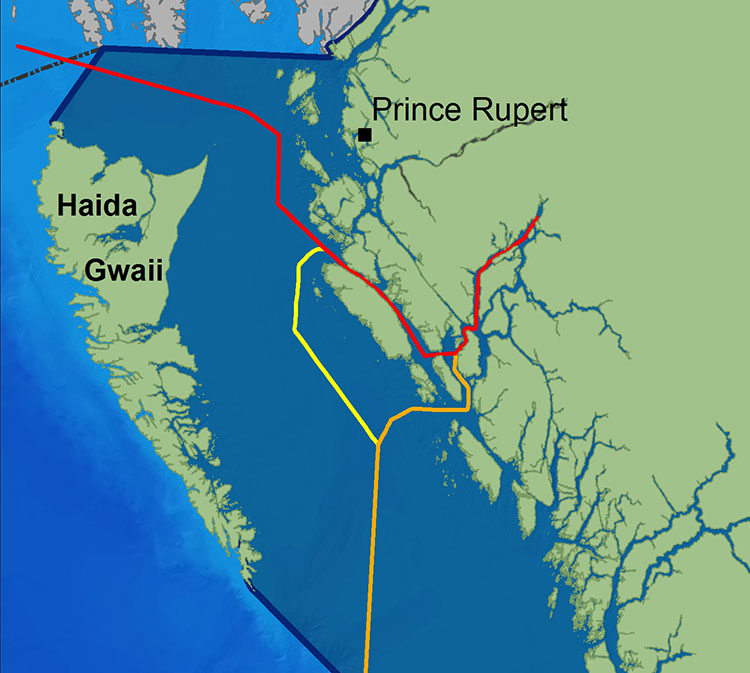
K’nabiyaaxl/Ashdown Conservancy covers 727 hectares of marine and uplands ecosystem on the northwest coast of British Columbia, south of Gil Island. The conservancy is 40 kilometres south of Hartley Bay and 120 kilometres southwest of Kitimat. The conservancy is in the traditional territory of the Gitga’at First Nation.
Although not well known outside the Kitimat region, Ashdown Island did receive some measure of fame because it was one of the islands that disappeared from Enbridge’s promotional animation of the tanker route for diluted bitumen from Kitimat to Asia if the controversial Northern Gateway project goes ahead. As well as a haven for wildlife, Ashdown is known as a prime halibut fishing area.
Ashdown Island study area (BC Parks)
Ashdown Island is on the proposed “Southern Approach” for Enbridge’s tanker traffic routes.
The area and nearby waters have been and continue to be intensively used by the Gitga’at people for cultural, social and economic purposes. In Tsimshian language (Sm’algyax), K’nabiyaaxl means “place where cliff” – which is located on the west side of Ashdown Island.
The conservancy encompasses all of Ashdown Island and the foreshore area
and land covered by water within 200 metres of the high tide line. It
has high intertidal values, especially for seaweed, and contains an important
Steller Sea Lion haulout. The waters around the island support important Gitga’at
community fisheries.
Although in Gitga’at traditional territory, the plan notes that the Haisla, the Kitasoo community of Klemtu; and Gitxaala community of Kitkatla on Dolphin Island should be consulted.
It goes on to say:
The conservancy protects an entire small island representative of the Hecate Lowlands Ecosection. The island’s foreshore marine environments include high value intertidal areas which provide high value habitat for important marine wildlife species and migratory birds. The conservancy also protects a haulout for Stellar Sea Lions (Eumetopias jubatus), a species of concern (provincially blue- listed3)…
Stellar Sea Lions use small islets off the south end of Ashdown Island as a winter
haulout, with up to 12 pups and 107 adults observed
The plans lists the Humpback Whale (Blue-listed, S1N); the. Killer Whale (Red- or Blue-listed, S2 or S3 depending on sub-species); and the Fin Whale; as Ashdown Island species at risk. (SARA species schedule procedure site)
As well:
The conservancy contains seven hectares of potential Marbled Murrelet habitat
which, although small, may provide important habitat when combined with core
Marbled Murrelet habitat in nearby areas.
K’nabiyaaxl’s remote location provides an excellent opportunity for maintaining
biological diversity and natural environment values. This habitat should not be
disturbed by conservancy use and development.
The island and the near shore are also part of the Gitga’at’s rich cultural heritage.
The conservancy is near the seasonal Gitga’at village camp of K’yel. The Gitga’at
travel in the spring from Hartley Bay to K’yel, which they use as a base for conducting intensive marine and intertidal harvesting and hunting activity.
Since time immemorial, the Gitga’at people have harvested fish and marine
mammal species in waters adjacent to K’nabiyaaxl. They also collect seaweed,
plants and berries from intertidal and upland areas on the island.
Archaeological sites are known to exist in the area. That the BC Archaeological
Branch does not have archaeological sites registered in the conservancy is not
indicative of the rich history of Gitga’at occupancy and use of K’nabiyaaxl.
The Northern Gateway Joint Review Panel has refused to consider the latest findings from the Department of Fisheries and Ocean on humpback whale critical habitat on the coast of British Columbia, including areas of ocean that could be on the route of tankers carrying diluted bitumen from Kitimat.
On October 21, 2013, Fisheries and Oceans released a report called Recovery Strategy for the North Pacific Humpback Whale (Megaptera novaeangliae) in Canada. The DFO report notes that humpback whales are a species of “special concern” by the Committee on the Status of Endangered Wildlife in Canada.
It is DFO policy to assist the humpback whale population to recover from the century of whaling that almost drove the species to extinction. The report identified four areas of “critical habitat” for humpbacks. One critical habitat zone is Gil Island at the mouth of Douglas Channel.
DFO map of humpback sightings on the BC coast. (DFO)
Last week, on November 13, Smithers based environmental activist Josette Weir filed a notice of motion with the JRP requesting that the panel consider the DFO report as late evidence.
Weir acknowledged that the JRP proceedings closed on June 24, after final arguments in Terrace, but she noted that rules allow the Board to override the final closure. She argued that the humpback report fell within the JRP’s mandate since the DFO report is “is likely to assist the Panel.”
Weir noted in her motion that there was insufficient information before the JRP that would identify critical humpback habitat.
She argued:
Three of the four critical known habitats are on the proposed tanker routes, and the Recovery Strategy acknowledges that other areas have not been identified. Without such information, it is impossible to assess the potential effects of the marine transport of bitumen on this endangered species.Activities likely to destroy or degrade critical habitat include vessel traffic, toxic spills, overfishing, seismic exploration, sonar and pile driving (i.e., activities that cause acoustic disturbance at levels that may affect foraging or communication, or result in the displacement of whales).
The report clearly identifies vessel traffic and toxic spills, which are associated with the Project as potential causes for destruction or degradation of the Humpback Whales’ critical habitat.
Weir went on to argue that the JRP had “insufficient information to develop relevant protection measures” because the humpback studies are ongoing, “meaning their results will not be available before decision.”
The Panel must consider this significant risk to an endangered listed species for which no meaningful protection measure can be offered against the risks associated with the Project.
Weir also noted that “No similar submission has been made by others, but I cannot predict if others will not see fit to do so.”
The JRP didn’t take long to reject Weir’s request, replying the next day, November 14.
In its response, the JRP cited the amended Joint Review Panel Agreement, signed after the passage of of the Jobs, Growth and Long-term Prosperity Act, the Omnibus Bill C-38, that “provides that the Panel’s recommendation report is to be submitted to the Minister of Natural Resources by 31 December 2013.”
The JRP then told Weir it didn’t have jurisdiction over endangered species (even if those species inhabit the tanker route) saying:
The Panel notes that the Recovery Strategy has been released in accordance with the provisions of the Species At Risk Act, as part of a legislative scheme that operates independently of this joint review process.
It goes on to say: “In this case, the Panel also notes that the Recovery Strategy was not authored by or for Ms. Wier.”
Humpback whale sightings at the Gil Island critical habitat. (DFO)
The executive summary of the DFO report noted:
Critical habitat for Humpback Whales in B.C. has been identified to the extent possible, based on the best available information. At present, there is insufficient information to identify other areas of critical habitat or to provide further details on the features and attributes present within the boundaries of identified critical habitat. Activities likely to destroy or degrade critical habitat include vessel traffic, toxic spills, overfishing, seismic exploration, sonar and pile driving (i.e., activities that cause acoustic disturbance at levels that may affect foraging or
communication, or result in the displacement of whales). A schedule of studies has been included to address uncertainties and provide further details on the critical habitat feature(s), as well as identify additional areas of critical habitat. It is anticipated that results from these studies will also assist in development of relevant protection measures for the critical habitat feature(s).
In the part of the report on the danger of toxic spills to humpbacks, the DFO report mentions that sinking of the BC ferry Queen of the North:
Toxic spills have occurred impacting marine habitat along the B.C. coast. For example, the Nestucca oil spill (1988) resulted in 875 tonnes of oil spilled in Gray’s Harbor, Washington. Oil slicks from this spill drifted into Canadian waters, including Humpback Whale habitat. In 2006, a tanker ruptured in Howe Sound, B.C. spilling approximately 50 tonnes of bunker fuel into coastal waters. In 2007, a barge carrying vehicles and forestry equipment sank near the Robson Bight-Michael Bigg Ecological Reserve within the critical habitat for Northern Resident Killer Whales, spilling an estimated 200 litres of fuel. The barge and equipment (including a 10,000L
diesel tank) were recovered without incident. When the Queen of the North sank on March 22, 2006, with 225,000 L of diesel fuel, 15,000 L of light oil, 3,200 L of hydraulic fluid, and 3,200 of stern tube oil, it did so on the tanker route to Kitimat, which is currently the subject of a pipeline and port proposal and within the current boundaries of Humpback Whale critical habitat
The DFO report also takes a crtical look at vessel strikes
In B.C. waters, Humpback Whales are the most common species of cetacean struck by vessels, as reported to the Marine Mammal Response Network. Between 2001 and 2008, there were 21 reports of vessel strikes involving Humpback Whales. Of these, 15 were witnessed collision events while the remaining 6 were of live individuals documented with fresh injuries consistent with recent blunt force trauma or propeller lacerations from a vessel strike.
Overall, vessel strikes can cause injuries ranging from scarring to direct mortality of individual whales. Some stranded Humpback Whales that showed no obvious external trauma, have been shown from necropsy to have internal injuries consistent with vessel strikes… It is unknown how many whales have died as a result of vessel strikes in B.C. waters. To date, only one reported dead Humpback Whale presented with evidence consistent with blunt force trauma and lacerations resulting from a vessel strike…
There are no confirmed reports of Humpback Whale collisions in B.C. waters attributed to shipping, cruise ship or ferry traffic. However, larger ships are far less likely to detect the physical impact of a collision than smaller vessels, and this could account for the lack of reported strikes. Collisions with large vessels may be more common than reported, especially in areas where larger vessel traffic is concentrated.
Despite the fact that collisions may only affect a small proportion of the overall Humpback Whale population, vessel strikes may be a cause for concern for some local and seasonal areas of high ship traffic.. In B.C., areas of high probability of humpback-vessel interaction include Johnstone Strait off northeast Vancouver Island, Juan de Fuca Strait off southwest Vancouver Island, Dixon Entrance and the “Inside Passage” off the northern B.C. mainland which include portions of two of the identified critical habitat areas..
The JRP also said
As the Panel has mentioned previously during the hearing, the later in the joint review process that new evidence is sought to be filed the greater the likelihood of the prejudice to parties. The Panel is of the view that permitting the Recovery Strategy to be filed at this late stage in the hearing process would be prejudicial to the joint review process.
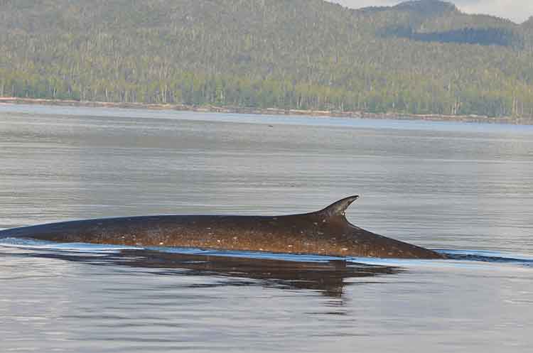
Fin whale in Squally Channel (Courtesy Chris Picard)
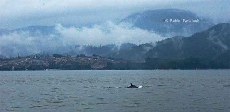
Whales are coming back to Douglas Channel.
In 2013, many Kitimat residents with long experience on the water have reported and are still reporting more sightings of both orcas and humpback whales.
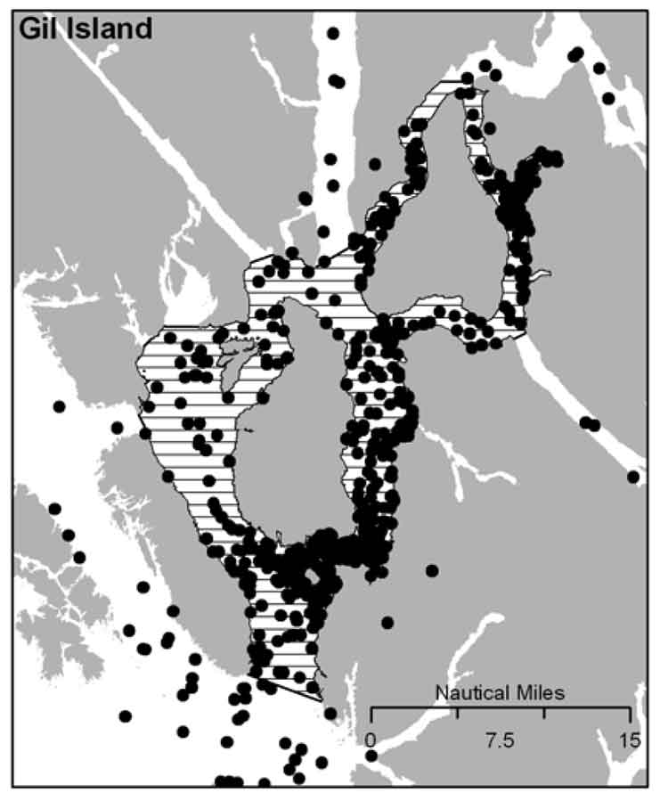
Add to this a recently published scientific study that shows the number of humpbacks at the mouth of the channel near Gil Island has doubled in the past decade, with the study saying there were 137 identifiable whales in 2011.
So why are the whales returning? Chris Picard, Science Director for the Gitga’at First Nation and one of the co-authors of the study believes that answer is simple. There are, so far, three species of whales seen in the area, humpbacks, orcas and fin whales. It is only now, Picard believes, that the humpback and fin whale populations are recovering from a century of whaling.
The study estimates there were once about 15,000 humpback whales in the North Pacific when whalers began hunting the animals. That number was down to 1,400 when whale hunting was stopped in Canada in 1966.
As whale numbers increase, they are searching for the rich food sources found in the Channel, both at the mouth around near Gil Island where the study took place and as far north as the Kildala Arm and Clio Bay.
“One of the things the humpbacks like to do when they are on our coast or the Alaskan coast and that is they feed,” Picard said, “So they are really targeting areas that there is a high density of their preferred prey, krill or herring or other schooling fish, sardines in some years.”
So far the study has concentrated in Gitga’at traditional territory around the mouth of Douglas Channel near Gil Island. Picard says increasing the study area to include more of Douglas Channel is a good idea, but would require more resources than are currently available. “We’d like to continue with the study consistent with the work that we have been doing. Considering what we’re seeing in the local Douglas Channel area, Wright Sound, Gil Island, it can be very worthwhile.
“We are going to continue with our current study which involve getting to know how many humpbacks are using the area and continue with the study that we just published to see if numbers continue to increase or to see whether or if they do start to stabilize at some number,” Picard said. “With more and more proposals for increased shipping, we get to see any changes with humpback numbers that may be linked to increased shipping. We’ll continue to monitor the humpback population; not just their numbers but also their distribution in the area. We’ll continue to monitor that, again in relation to the various shipping proposals and activities that are proposed.”
It was during that study on humpbacks that the researchers from the Gitga’at Nation and the Cetacean Lab noticed the appearance of fin whales, another species that had been hit hard by whaling. (“We’ve worked very closely with the Cetacean Lab group and frankly without their help we would never have published any of this work because their data certainly was instrumental in getting the overall data set that made possible a publishable study,” Picard said.)
“We have observed is that fin whales have increased in their abundance in the area quite a bit, “ Picard said. “I can remember when we first started doing surveys, there were not too many. We’ve gone from seeing a couple over the course of an entire year. Now when we do our marine mammal surveys in the area the fin whales you pretty much see in every survey and in more and more numbers. So it’s quite encouraging to see that fin whales are becoming more abundent in the area. They were also hunted, so if you factor in the days of commercial whaling operations, that of course has stopped, so its encouraging to see that their numbers are coming back too.
The fin whales tend to be found in many of the same areas at the humpack whales are using, Caamaño Sound, Campania Sound and areas south of Gil Island. “we’ve also seen them more in the interior waters like Squally Channel, Wright Sound, Whale Channel, similar to the areas where we see the humpbacks.
“We haven’t done the same level of detailed analysis on the fin whale distribution as we have with the humpback, so it’s just my overall impression that they’re using similar habitats.
“It’s unique for fin whales to be using these more confined waters. It is my understanding that they are more of an open water species. I think that makes the area fairly unique,” he said.
Picard added it would be interesting to do a historic study to see how many fin whales were taken by whalers in the previous decades, especially in Caamaño Sound, Squally Channel and Wright Sound.
“The fact that we saw so many humpbacks relative to the size of the area, which is pretty small relative to the whole coast, so there must be a high abundance of food in the area,” Picard said.
“I’d like to get a better understanding of what is really driving the food abundance in the area. What is the oceanography in the area, what are the currents, what is driving that high area of biological activity that the whales seeming to be homing in on.”
Humpback whale in the Kildala Arm, September 14, 2013. (Robin Rowland)
That means, Picard believes, that there could be krill and juvenile herring schooling in the upper Douglas Channel and that is what is attracting the whales.
One of the next steps, Picard said, is to study social interaction among whales. “We do take identification photographs, so we get a sense of who’s hanging out with who; who is bringing their calves into the area to introduce them into what seems to be very good whale habitat,” Picard.
So one aim of a future study would be to se what role social interactions play in the increased whale sightings in the Douglas Channel. He also wants to know what role are the potential negative impacts on that whale social interaction comes noise impacts, or being struck by ships, and the potential environmental affects of oil spills. “So do these social interactions decrease as the impacts increase, does that mean there are going to be fewer whales that come into this area? Those are some of the questions we want to address.”
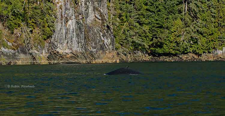
A humpback whale, seen here by its small dorsal fin, swims past the Chevron Apache KM LNG site at Bish Cove on Douglas Channel, August 21, 2013. (Robin Rowland/Northwest Coast Energy News)
Updated with comments from Gitga’at First Nation, Nathan Cullen and Shell Canada.
Gil Island is a “critical habitat” for the world’s humpback whales, whose numbers are increasing in Douglas Channel, Wright Sound, Estevan Sound and Camano Sound and nearby waters, according to a study released Wednesday, September 11, 2013. The study also goes on to warn that potential tanker traffic through the “geographic bottleneck” on Douglas Channel to and from Kitimat could threaten that crucial “pit stop” for the humpback whales.
The study, “Abundance and Survival of Pacific Humpback Whales in a Proposed Critical Habitat Area,” by Erin Ashe, of the University of St. Andrews, in Scotland, Janie Wray of Oceans Initiative on Pearse Island, Christopher Picard of the North Coast Caetacian Society in Hartley Bay and Rob Williams of the Gitga’at Nation Lands and Marine Resources Deptartment, is published in the jourrnal PLOS One.
The research team estimated the abundance of Pacific humpback whales by using photo-identification surveillance of adult humpbacks. They found that the number of humpback whales in this region increased each year, and doubled from 2004 to 2011, resulting in a total of 137 identifiable whales in 2011. The survey was conducted year-round. Abundance was estimated only during the summer months of July to September, when the migrating whale population is largest.
The survey focused on summer feeding regions in the northwestern BC coastal fjords that serve as a “pit stop” for whales between migrations. Migrating whales travel to the BC coast from calving grounds as far away as Mexico, Hawaii or Japan. After several months without feeding, the humpbacks arrive in BC, and, the study says, show “strong site fidelity to local feeding grounds” around the entrance to Douglas Channel.
The authors estimated that “survivorship,” the average probability of an adult whale surviving from one year to the next on the northwest coast of British Columbia is among the highest reported anywhere for the species. During “this critical refueling stage in these waters, the whales are more vulnerable to environmental stressors, such as those potentially created by increasing tourism and industrial development in the region.”
The study also says that study area has also been identified as candidate critical habitat for northern resident killer whales and notes the region “has been recolonized by fin whales in recent years.” (With details on the fin whales to come in future studies)
The study estimates there were once about 15,000 humpback whales in the North Pacific when whalers began hunting the animals. That number was down to 1,400 when whale hunting was stopped in Canada in 1966. “It is therefore good news that the segment of the population using our study area is growing and adult survival is near the limit that one would expect for this species. That said, although the population is recovering, there is no evidence that it has yet fully recovered to pre-exploitation levels in BC and we do not wish to become complacent.” the study says.
It goes on to say:
Humpback whales may be facing increasing threats in at least one of their proposed critical habitats in BC. Numerous port facility expansions and new terminal proposals, including numerous crude oil and liquefied natural gas (LNG) export proposals, could substantially increase deep-sea shipping traffic through BC’s north and central coast waters. Such developments could exacerbate oil spill, acoustic disturbance, and ship strike risks to humpbacks. In particular, the Gil Island proposed critical habitat area where our work was conducted, spatially corresponds with all shipping routes leading to Kitimat, BC port facilities that are currently being considered by regulatory agencies for high-volume crude oil and LNG tanker traffic and other increased shipping activities.
The monitoring program showed that “a relatively large fraction of BC’s humpback whales rely on the waters around Gil Island, given the small size of the study area.”
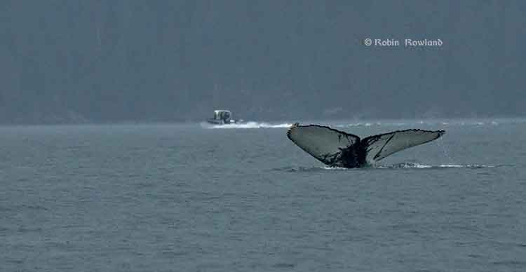
The tail fins of a humpback whale are seen in Douglas Channel near Bish Cove, as a fishing boat speeds toward Kitimat harbour in a rain storm on Aug. 21, 2013. (Robin Rowland/Northwest Coast Energy News)
The study warns:
This high reliance on relatively small fractions of available habitat has important implications for conservation and management. It lends support to the proposal to designate the current study area as part of the population’s critical habitat…
This also suggests that area-based management for cetaceans can effectively target small areas if these areas are chosen carefully. The corollary to this, though, is that a tendency for animals to be concentrated or aggregated in small areas lends them vulnerable to catastrophic events like oil spills and ship strikes. Critical habitats like the Gil Island waters are therefore a mixed blessing when high densities of whales are found in geographic bottlenecks that also funnel and concentrate shipping traffic. Anthropogenic threats to this must be evaluated not only in terms of the proportion of available habitat that this area represents, but also in terms of its critical importance to large numbers of whales for critical life-history processes. The risk and ecological consequences of an oil spill in this region would increase substantially if proposals were approved to ship large volumes of oil and LNG traffic through the Gil Island waters. Studies in Pacific waters similar to our study area suggest that oil spills can have severe and chronic impacts to cetacean populations and it is uncertain whether affected populations can recover from such perturbations.
One reason for the study is that while the humpback is considered an endangered species in the United States, in Canada it is listed as “threatened” under Canada’s Species at Risk Act and the increasing numbers could mean that the humpback is downgraded to “special concern.”
The study was based on what is called “community based science,” a cost-effective partnership between scientists, the Gitga’at Nation and other First Nations, NGOs and the Department of Fisheries and Oceans.
As part of its Pacific humpback whale recovery strategy, DFO has proposed four areas as candidate critical habitat. One criterion for designating critical habitats within northern BC coast feeding grounds is that inlets are used for specialized ‘‘bubble-net’’ feeding behaviour (where the humpbacks create a fishing net of bubbles to catch their prey).
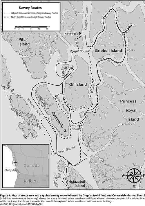
At the start of the study, the team had noted that “mainland inlets have been somewhat under-represented in habitat studies” and so they began working on the photo-identification of the humpbacks, using two research groups, the North Coast Cetacean Society and the Gitga’at Lands and Marine Resources Department. Surveys were conducted as weather permitted throughout the year from April to November (with occasional trips in February, March and December), from 2004 to 2011.
The aim of the study was to “collect as many high-quality photographs of individually recognizable humpback whales as possible within the study area [referred to in the study as ‘Gil Island waters’’] from Estevan Sound in the west to Ursula Channel in the east. One 27 foot and one 18 foot boat were used to conduct the surveys. A total of 374 photo- identification surveys conducted over 47 months resulted in a catalogue of 177 high-quality, unique identifications of individual humpback whales.
Information also came from “an informal sightings network including local fishermen and tourism operators who reported humpback and killer whale sightings over VHF radio;” hydrophones monitored for vocalizing humpback whales; and visual monitoring from the land-based Cetacealab facility on the south end of Gil Island.
When a humpback was sighted, they were identified by the fingerprint like tail flukes and the numbers cataloged.
The study was funded by grants to Cetacealab and Gitga’at First Nation from Julie Walters and Sam Rose, and from Fisheries and Oceans Canada (Cetacean Research Program, Species at Risk Program). There was also support from King Pacific Lodge.
–
“The importance of our territorial waters for humpback and other species of whales, should give pause to those who would propose tanker routes through the Douglas Channel,” said Arnold Clifton, Chief Councillor of the Gitga’at First Nation. “The increase in whales in our territory coincides with low shipping traffic, however current proposals would increase shipping traffic to unprecedented levels. We remain resolute in our determination to protect whales and the natural heritage of our territory from tankers and other developments that would put them at risk.”
“Our study shows that while still vulnerable, humpback whales are recovering, and this area plays an important role in supporting their numbers,” said lead author, Erin Ashe, a PhD candidate at the University of St. Andrews and a co-founder of Oceans Initiative. “Identifying and protecting critical habitat is one of the most effective ways to support endangered species recovery.”
The waters around Gil Island are especially rich habitat for humpback whales, due to high abundance of their preferred foods, such as krill and herring and due to the remote nature of the coastal fjords. Humpbacks, which rely on acoustic communication, are sensitive to noise pollution from ship traffic.
“It is Cetacea Lab’s contention that all levels of government must collaborate with the Gitga’at First Nation and others in protecting humpback whales from the risk of increased tanker traffic,” said Janie Wray, whale researcher with Cetacea Lab. “This study represents the best available scientific information about the importance of this area to humpback whales. Over the course of our study, we have observed the population more than double, with mothers returning year after year with their calves, introducing the next generation of juvenile whales to the nutrient-rich feeding grounds of Douglas Channel to Caamano Sound.”
In his biweekly conference call with Northwest BC reporters, Skeena Bulkley Valley MP Nathan Cullen said: “I don’t get a sense from the way that the federal government has designed this [referring to Enbridge Northern Gateway] project, that on the marine side, any of these things are important to Mr. Harper. When you start to place down the most important values and certainly for British Columbians and Canadians, protecting a humpback feeding ground would seem like an important value in the Great Bear Rainforest, you start to see where the limits and the restrictions are on any idea of moving oil super tankers through such a narrow place. It’s just another bit of evidence, a bit of science that says this is difficult, if not impossible, and Enbridge’s project has made so many of those arguments more and more clear as we start to bring science to the table.
“It’s so frustrating for people that evidence, our opinions and our values just don’t seem to matter to the federal government. They already said yes to this thing years ago and damn the science, damn anything that comes their way. That’s not going to work, not going to work for us and not going to work for the humpback whales.”
A spokesperson for Shell’s LNG Canada project, noting that the company officials had not yet read the study, said, “It’s early days for the proposed project and the start of a thorough regulatory process. We welcome contributions and thoughts on important matters. We will look at this study. As with any project in Canada we work with local First Nations and local communities to minimize the impact of our activities.”
Neither Enbridge Northern Gateway nor Apache, a partner in the KM LNG project, responded to a request for comment.