Editorial: On the Simushir, Oceans Minister Gail Shea takes ministerial responsibility to a new low—the bottom of the sea

On Monday, October 20, 2014, the Minister of Fisheries and Oceans, Gail Shea, stood in the House of Commons during Question Period and proved she is not up for the job.

Answering questions from  Opposition MPs about the incident of the Russian container ship, Simushir, which drifted dangerously close to the coast of Haida Gwaii, Shea got up and read a prepared script, a script with answers which ignored centuries of the laws and custom of the sea, as well as Canada’s own laws and treaty obligations, answers probably written by what are now known as “the kids in short pants” in the Prime Minister’s Office.

There was a time in this country when some ministers of the Crown took their responsibilities seriously. That idea that has decayed over the years and now has been gutted by the adminstration of Stephen Harper. As Ottawa pundits have noted recently, only a small handful of cabinet ministers in the Harper government have any real responsibility and only those  are permitted to answer questions by themselves in the Commons. According to most Ottawa insiders, the less important ministers, like Shea, are basically told what to do by the prime minister’s office.

Gail Shea, Minister of Fisheries and Oceans, visited the Canadian Coast Guard Ship Leonard J. Cowley on Friday, December 6,  2013, to examine the fast rescue craft launching mechanism for offshore fishery patrols with Regional Director, Fleet, Stephen Decker and Captain Kerry Evely, Commanding Officer. The Cowley conducts fisheries patrols and monitors fishing activities under Canada's commitment to the Northwest Atlantic Fisheries Organization. (DFO)
Gail Shea, Minister of Fisheries and Oceans, visited the Canadian Coast Guard Ship Leonard J. Cowley on Friday, December 6, 2013, to examine the fast rescue craft launching mechanism for offshore fishery patrols with Regional Director, Fleet, Stephen Decker and Captain Kerry Evely, Commanding Officer. The Cowley conducts fisheries patrols and monitors fishing activities under Canada’s commitment to the Northwest Atlantic Fisheries Organization. (DFO)

If the House of Commons under Harper could fall any lower, Shea’s attitude (or more likely the PMO’s attitude)  on ship and coastal safety takes the Commons and ministerial responsibility to a new low—the bottom of the sea.

Nathan Cullen, NDP MP for Skeena Bulkley Valley, who represents Haida Gwaii first asked. “Mr. Speaker, on Friday, a Russian ship carrying more than 500 million litres of bunker fuel lost all power just off the coast of Haida Gwaii.The Canadian Coast Guard vessel, the Gordon Reid, was hundreds of kilometres away, and it took almost 20 hours for it to reach the drifting ship. Thankfully, favourable winds helped keep the ship from running aground, and a private American tugboat eventually towed it to shore. Is the minister comfortable with a marine safety plan that is based on a U.S. tugboat and blind luck in order to keep B.C.’s coast safe?”

Shea responded.

“Mr. Speaker, luck had nothing to do with the situation.  The Russian ship lost power outside Canadian waters in very rough weather. The private sector provides towing service to the marine industry. We are grateful that the Canadian Coast Guard was able to keep the situation under control in very difficult conditions until the tug arrived from Prince Rupert.”

Cullen tried again:

“Mr. Speaker, if the government really wanted to show its gratitude to the Canadian Coast Guard maybe it would not have cut $20 million and 300 personnel from its budget. Even after the Gordon Reid arrived, its tow cable snapped three times. The Russian ship was only about a third as big as the huge supertankers that northern gateway would bring to the very same waters off the west coast. How can Conservatives, especially B.C. Conservatives, back their government’s plan to put hundreds of oil supertankers off the B.C. coast when we do not even have the capacity to protect ourselves right now?”

Shea replied: “Mr. Speaker, this Russian ship lost power outside of Canadian waters. The Canadian Coast Guard responded and kept the situation under control, under very difficult conditions, until the tug arrived from Prince Rupert.

We as a government have committed $6.8 billion through the renewal of the Coast Guard fleet, which demonstrates our support for the safety and security of our marine industries and for our environment.”

Related Link: Canadian Coast Guard Mid-Shore Patrol Vessel program

Next to try was Liberal MP Lawrence MacAulay from Cardigan.

“Mr. Speaker, the Russian container ship that drifted off the west coast raises serious concerns about the response capability of the Canadian Coast Guard. This serious situation was only under control when a U.S. tugboat arrived.”

Again Shea read her script: “This Russian ship lost power outside Canadian waters.  On the west coast, the private sector provides towing services to the marine industry.’

The final attempt by Liberal Joyce Murray, from Vancouver Quadra, also led to a scripted answer. “ this was a private towing vessel that came to tow the vessel that was in trouble.”

Shea’s answers, especially her repeated reference to “territorial waters” set off a series of “What the…?” posts on Twitter from west coast mariners and sailors, wondering if Shea knew anything about maritime law.

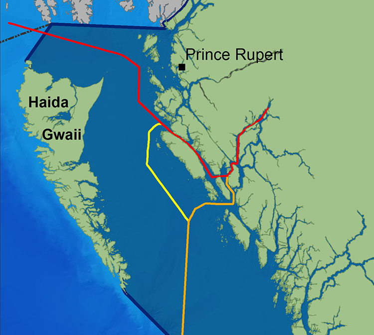
The first question one must ask was Shea actually not telling the whole truth to the House of Commons (which is forbidden by House rules) when she said the Simushir was outside Canadian waters? The Haida Nation, in a news release, (pdf) says the Simushir was “drifting about 12 Nautical Miles North West of Gowgaia Bay located off Moresby Island off Haida Gwaii.”

International law defines territorial waters  as a belt of coastal waters extending at most 12 nautical miles (22.2 km; 13.8 mi) from the baseline (usually the mean low-water mark) of a coastal state.

As Shea’s own DFO website says Canada has exercised jurisdiction over the territorial sea on its east and west coasts out to 12 nautical miles since 1970, first under the Territorial Sea and Fishing Zones Act and now under the Oceans Act. The baselines for measuring the territorial sea were originally set in 1967. While the exact position can and should be confirmed by the ship’s navigation logs and GPS track, it is clear that the container vessel could have been at one point after it lost power within Canada’s territorial waters.

Even if the Simushir wasn’t exactly within territorial waters, the ship was in what again Shea’s own DFO website calls the “contiguous zone “an area of the sea adjacent to and beyond the territorial sea. Its outer limit measures 24 nautical miles from the normal baseline zone.” In any case, the Simushir was well within what Canada says is its “exclusive economic zone” which extends 200 nautical miles from the coastal baseline.

Law of the Sea

So here is the first question about Shea’s competence.

How could she not know that the Simushir was well within Canadian jurisdiction, as defined by her own department’s website? Even if the minister hadn’t read the departmental website, wasn’t she properly briefed by DFO officials?

The second point, is that whether or not the Simushir was in  actually in Canada’s territorial waters is irrelevant. Custom going back centuries, and now the United Nations Convention on the Law of the Sea  and even the Canada Shipping Act all require the master of a capable vessel to render assistance once that vessel receives a distress call or sees that another vessel is in distress.

The Safety of Life at Sea Convention

… the master of a ship at sea which is in a position to be able to provide assistance, on receiving a signal from any source that persons are in distress at sea, is bound to proceed with all speed to their assistance, if possible informing them or the search and rescue service that the ship is doing so.

And the Canada Shipping Act requires

Every qualified person who is the master of a vessel in any waters, on receiving a signal from any source that a person, a vessel or an aircraft is in distress, shall proceed with all speed to render assistance and shall, if possible, inform the persons in distress or the sender of the signal.

The master of a vessel in Canadian waters and every qualified person who is the master of avessel in any waters shall render assistance to every person who is found at sea and in danger of being lost.

Note the phrase any waters. Not just in Canadian territorial waters as the Shea, the minister responsible for the ocean seemed to imply in her Commons answers.

That once again calls into question Shea’s fitness to be a minister of the Crown.

If she did not know about the UN conventions on the law of the sea, of which Canada is signatory, or the Canada Shipping Act, she is not up for the job as Minister of Fisheries and Oceans.

If, as the minister responsible for oceans, she knew the law and was told by the PMO to mislead the House of Commons, she is is irresponsible and MPs should ask the Speaker if she actually broke the rules of the House.

 UN training document on the Law of the Sea Convention, including rescue at sea.  (pdf)

Regulation Seven of the Annex on Search and Rescue Services states

 Each Contracting Government undertakes to ensure that necessary arrangements are made for distress communication and co-ordination in their area of responsibility and for the rescue of persons in distress at sea around its coasts. These arrangements shall include the establishment, operation and maintenance of such search and rescue facilities as are deemed practicable and necessary, having regard to the density of the seagoing traffic and the navigational dangers, and shall, so far as possible, provide adequate means of locating and rescuing such persons.

Note that the regulation does not say within territorial waters, but “around its coasts.”

Rendering assistance

Canada has always rendered assistance to distressed vessels not just up and down the coast but around the world. Take the case of HMCS Chartlottetown. On February 3, 2008, HMCS Chartlottetown on anti-piracy and anti-terrorist patrol in the North Arabian Sea, spotted a rusty barge with some men stranded on the deck. It turned out the men were from Pakistan and that the vessel towing the barge had sunk with all hands, leaving only the men on the barge alive. The North Arabian Sea is far out side Canadian territorial waters.

In February, 2008. the crew of HMS Charlottown rescued the crew of a Pakistani barge that was drifting in the North Arabian sea after the tug that was hauling the barge sank. (MCS CHARLOTTETOWN’s approach team speaks to Pakistani crewmembers who were stranded on a barge after the vessel towing it sunk with their fellow crewmembers on board in the Northern Arabian Sea. MCS CHARLOTTETOWN’s approach team speaks to Pakistani crew members who were stranded on a barge after the vessel towing it sunk with their fellow crewmembers on board in the Northern Arabian Sea. (Cpl Robert LeBlanc,/Canadian Forces Combat Camera)
In February, 2008. the crew of HMCS Charlottetown rescued the crew of a Pakistani barge that was drifting in the North Arabian sea after the tug that was hauling the barge sank. (Cpl Robert LeBlanc,/Canadian Forces Combat Camera)

On must wonder then if the Harper Government, or at least Minister Shea is suggesting that this country ignore centuries of maritime law and custom and, in the future, pass that barge by because it was not in Canadian waters?

Perhaps buried in the next omnibus bill we will see the Harper Government restrict rescue at sea to Canadian territorial waters. Farfetched? Well that is what Minister Shea’s answer in the Commons seems to suggest.

Given the cutbacks to the Coast Guard services over the past few years, and if there are going to be large tankers, whether LNG or bitumen, on the west coast, it is an open question whether or not the Harper government has actually made  those “arrangements shall include the establishment, operation and maintenance of such search and rescue facilities as are deemed practicable and necessary, having regard to the density of the seagoing traffic and the navigational dangers, and shall, so far as possible, provide adequate means of locating and rescuing such persons.”

Now comes the question of the use of the tug Barbara Foss and the two Smit tugs that later joined to tow the Simushir into Prince Rupert harbour.

It is the responibility of the owner or manager of a disabled vessel, large or small, to contract with a tug or towing service to safely take it back to port. But, and it’s a big but, the tow begins only when it is safe to do so, if there is a danger of the ship foundering, sinking or running aground, it is the obligation of all the responding vessels to render assistance, not just the tug contracted to do the job.

(There are reports that the Simushir owners chose to hire the Barbara Foss rather than the heavy duty Smit tugs available at Prince Rupert. Jonathan Whitworth, CEO of Seaspan told Gary Mason of The Globe and Mail that there are about 80 boats on the west coast, capable of  heavy-duty towing, but noted that as in the case of the Simushir, those vessels may not be available when needed)

While around the Lower Mainland of BC, even a small boat that has run out of gas or has engine trouble can get commercial assistance from many service providers, the same is not true of the north coast, or at Haida Gwaii, where are no such regular services. Seapan’s Whitworth told The Globe and Mail there is often a 6,000 horsepower log hauling tug that works off Haida Gwaii. but he also noted that it would be too expensive to have a tug permanently moored on the archipelago.

That means mariners who run out of gas or have engine trouble, say on Douglas Channel, have to call Prince Rupert Coast Guard radio and request assistance either from nearby vessels or from the volunteer Royal Canadian Marine Search and Rescue  service. RCMSAR policy says that a the rescue boat will not tow a vessel if “commercial assistance is reguarly available.” If commercial assistance is not available RCMSAR is only obligated to tow the boat as far as a “safe haven,” where the boat can tie up safely or contract for that “commercial assistance.”

Here on Douglas Channel the safe haven is usually Kitimat harbour and thus during the summer frequently either a good  Samaritan vessel or RCMSAR take the disabled vessel all the way to MK Bay.

Shea’s pat answer to the Opposition questions only betrayed the fact that the east coast minister is woefully ignorant of conditions on the northern coast of British Columbia.

In the old days, a minister who screwed up so badly would be asked to resign. That never happens any more. Ministerial responsibility has sunk to the bottom of the sea.

The bigger picture question seems to be. Why, if the Harper government is so anxious to get hydrocarbons, whether bitumen or natural gas to “tide water” does it keep going out of its way to show its contempt for the people who live on Canada’s west coast?

A note for the voters of Prince Edward Island, where Shea is the member for Egmont. Consider this, if a ship gets into trouble outside the 12 mile limit, trouble that could threaten your beautiful red sandy beaches, you’re likely on your own.

Fossil hedgehog, tapir lived in ancient rain forest at threatened Driftwood Canyon Park near Smithers

About 52 million years ago what is now the Bulkley Valley was home to a tiny hedgehog  and an ancient ancestor of tapirs, who lived on the shores of a placid lake surrounded by  a lush upland forest.

The newly discovered fossils at Driftwood Canyon near Smithers are significant advance in the study of the ancient history of the region. That’s because while the Driftwood Canyon Provincial Park is known for beautifully preserved fossils of leaves, fishes and insects, these are the first mammalian remains found at the site.

Eocene lake
An artist’s impression of the 52-million year old early Eocene rain forest around lake in what is now the Bulkley Valley. The tapiroid Heptodon drinks in the shallows, while the small proto-hedgehog Silvacola acares stalks a green lacewing(Pseudochrysopa harveyi). ( Illustration © by Julius T. Csotonyi. used by permission)

The fossil hedgehog and tapir are even more significant because at the time they lived near an upland lake, Earth was going through a period of rapid global warming, now called the Paleocene-Eocene Thermal Maximum.

In the past couple of years, climatologists and paleontologists have started to play closer attention to the Thermal Maximum period in hopes of understanding what could happen during climate change today.

Driftwood Canyon first became famous in 1977 with the discovery of oldest known ancestor of salmons, Eosalmo driftwoodensis, which lived in an  Eocene lake at Driftwood Canyon.

Today’s  study says the ancient hedgehog is a species hitherto unknown to science. It is named Silvacola acares, which means “tiny forest dweller,” since this minute hedgehog likely had a body length of only two to two and half inches or five to six centimetres, about the size of an adult human thumb.

“It is quite tiny and comparable in size to some of today’s shrews,” said Dr. Jaelyn Eberle of the University of Colorado, lead author of the study.   She speculated Silvacola may have fed on insects, plants and perhaps seeds.

Did it have quills like contemporary hedgehogs? “We can’t say for sure,” Eberle said. “But there are ancestral hedgehogs living in Europe about the same time that had bristly hair covering them, so it is plausible Silvacola did too.”

The  delicate fossil jaw of Silvacola was not freed from the surrounding rock as is typical for fossils. Instead it was studied using an industrial high resolution CT (computed tomography) scanner at Penn State University so it could be studied without risking damage to its tiny teeth.

Hedgehogs are no longer found naturally  in North America. Modern hedgehogs and their relatives are restricted to Europe, Asia, and Africa. Hedgehogs have become quite the rage as pets in North America in the past several years. The most common hedgehog pet today is the African pygmy hedgehog, which is up to four times the length of the diminutive Silvacola.

The other mammal, about the size of a medium-sized dog,  discovered at the site, is Heptodon, is an ancient relative of modern tapirs, which resemble small rhinos with no horns and a short, mobile, trunk or proboscis.

Heptodon was about half the size of today’s tapirs, and it lacked the short trunk that occurs on later species and their living cousins. Based upon its teeth, it was probably a leaf-eater, which fits nicely with the rain forest environment indicated by the fossil plants at Driftwood Canyon,”  Eberle said.

Most of the fossil-bearing rocks at Driftwood Canyon formed on the bottom of an ancient lake and are well-known for their exceptionally well-preserved leaves, insects, and fishes.

“The discovery in northern British Columbia of an early cousin to tapirs is intriguing because today’s tapirs live in the tropics. Its occurrence, alongside a diversity of fossil plants that indicates a rain forest, supports an idea put forward by others that tapirs and their extinct kin are good indicators of dense forests and high precipitation,” she said.

Forests, lakes, rivers

Fossil plants from the site indicate the area seldom experienced freezing temperatures and probably had a climate similar to that of Portland, Oregon, located roughly 1,126 kilometres or 700 miles to the south.

The current and previous studies have shown the hedgehog and tapid lived on the shores of a lake surrounded by a mixed conifer-broadleaf forest with redwoods, such as Metasequoia and Sequoia, cedars, fir, larch, golden larch, spruce, pine as well as rare ginkgoes. There were also broadleaf deciduous trees such as alder, birch,  sassafras, elms, and relatives of the oak family. In the lake were Azolla, a floating fern,  which are frequently found as preserved mats in the fossil shale of the cliff at Driftwood, which together with the fine preservation of the insects indicate a quiet water lake.

The remains on the hedgehog were found in the fossil lake bed while the tapir was found in river sediments.

The paleoclimate has been reconstructed suggesting the region had  a mean annual temperature of between 10 degrees C and 15 degrees C, with minimal winter freezing and annual precipitation of about 100 centimetres a year. Today, the mean annual temperature for Smithers is 4.2 degrees C with 50.85 centimetres of precipitation a year

Lost world

“Driftwood Canyon is a window into a lost world – an evolutionary experiment where palms grew beneath spruce trees and the insects included a mixture of Canadian and Australian species. Discovering mammals allows us to paint a more complete picture of this lost world,” said Dr. David Greenwood of Brandon University, a co-author of the study.

“The early Eocene is a time in the geological past that helps us understand how present day Canada came to have the temperate plants and animals it has today. However, it can also help us understand how the world may change as the global climate continues to warm.”

The Driftwood Canyon site is the northernmost of a series of Eocene lake sites spanning about 1000 kilometres that reach south from Smithers to Republic in northern Washington that the scientists call the Okanagan Highlands, with a mixture of temperate and tropical plants and animals and a high diversity of insects and plants.

Looting

While Driftwood Canyon is now among sites considered a key indicator of climate change 50 to 53 million years ago, the Harper government has cut almost all the funding for research into paleontology, not just at Driftwood Canyon but across the country, because looking for fossils doesn’t usually fit into the Conservative policy of only funding science that promotes industry.

“Within Canada, the only other fossil localities yielding mammals of similar age are from the Arctic, so these fossils from British Columbia help fill a significant geographic gap,” said Dr. Natalia Rybczynski of the Canadian Museum of Nature, a co-author of the study.

Other fossils of this age come from Wyoming and Colorado, some 4,345 kilometres or 2,700 miles to the south of the Arctic site of Ellesmere Island. In addition, sources have told Northwest Coast Energy News that the provincial budget for Driftwood Canyon, despite its significance, is the same  as other small parks of that size, with virtually no security to prevent fossils leaving the park, either in the hands of professional looters or if they are picked up and taken home by visitors.

There are consistent reports that looted fossils from Driftwood Canyon are regularly showing up at fossil shows in the United States.

Sources have told Northwest Coast Energy News that the provincial government has ignored requests to improve security at Driftwood Canyon because it is considered a small (just 21 hectares) low priority park off the main tourist routes, rather than a significant fossil site.

The mammal fossils were discovered in 2012 before the budget cuts and are now in the Royal British Columbia museum in Victoria. The fieldwork was supported by Natural Sciences and Engineering Research Council of Canada.

The study “Early Eocene mammals from the Driftwood Creek beds, Driftwood Canyon Provincial Park, Northern British Columbia ” was published in the July 8, 2014 edition of the Journal of Vertebrate Paleontology.

Fossil hunting at Driftwood Canyon
The fossil-bearing sediments at the “North Face” fossil site in Driftwood Canyon Provincial Park near Smithers. The layers of shale are the remains of old lake beds. The grey area near the bottom of the cliff shows where volcanic ash settled on the lake. The scientist in the lower part of the picture are excavating the fossil hedgehog. (Dave Greenwood/Brandon University)

BC calls for input on conservation plan for Ashdown Island, one of the “disappeared” on Douglas Channel

Ashdown Island
Sea lions basking on Ashdown Island (BC Parks)

BC Parks and the Gitga’at First Nation are calling for public input as they development a management plan for the K’nabiyaaxl/Ashdown Island Conservancy at the mouth of Douglas Channel.

BC Parks describes the area as:

K’nabiyaaxl/Ashdown Conservancy covers 727 hectares of marine and uplands ecosystem on the northwest coast of British Columbia, south of Gil Island. The conservancy is 40 kilometres south of Hartley Bay and 120 kilometres southwest of Kitimat. The conservancy is in the traditional territory of the Gitga’at First Nation.

The public has until December 9 to read the management plan and file comments with BC Parks and the Gitga’at Nation.

Although not well known outside the Kitimat region, Ashdown Island did receive some measure of fame because it was one of the islands that disappeared from Enbridge’s promotional animation of the tanker route for diluted bitumen from Kitimat to Asia if the controversial Northern Gateway project goes ahead. As well as a haven for wildlife, Ashdown is known as a prime halibut fishing area.

Ashdown Island
Ashdown Island study area (BC Parks)

Ashdown Island is on the proposed “Southern Approach” for Enbridge’s tanker traffic routes.

Tanker routes (Wikipedia from Living Oceans)


Recent studies by both Fisheries and Oceans and scientists have identified the area as “critical habitat” for the rebounding humpback whale population visiting the BC Coast. The Northern Gateway Joint Review panel recently refused to consider those studies because they were released after the deadline for filing evidence.

The BC management plan notes:

The area and nearby waters have been and continue to be intensively used by the Gitga’at people for cultural, social and economic purposes. In Tsimshian language (Sm’algyax), K’nabiyaaxl means “place where cliff” – which is located on the west side of Ashdown Island.

The conservancy encompasses all of Ashdown Island and the foreshore area
and land covered by water within 200 metres of the high tide line. It
has high intertidal values, especially for seaweed, and contains an important
Steller Sea Lion haulout. The waters around the island support important Gitga’at
community fisheries.


Although in Gitga’at traditional territory, the plan notes that the Haisla, the Kitasoo community of Klemtu; and Gitxaala community of Kitkatla on Dolphin Island should be consulted.

It goes on to say:

The conservancy protects an entire small island representative of the Hecate Lowlands Ecosection. The island’s foreshore marine environments include high value intertidal areas which provide high value habitat for important marine wildlife species and migratory birds. The conservancy also protects a haulout for Stellar Sea Lions (Eumetopias jubatus), a species of concern (provincially blue- listed3)…

Stellar Sea Lions use small islets off the south end of Ashdown Island as a winter
haulout, with up to 12 pups and 107 adults observed

The plans lists the Humpback Whale (Blue-listed, S1N); the. Killer Whale (Red- or Blue-listed, S2 or S3 depending on sub-species); and the Fin Whale; as Ashdown Island species at risk. (SARA species schedule procedure site)

As well:

The conservancy contains seven hectares of potential Marbled Murrelet habitat
which, although small, may provide important habitat when combined with core
Marbled Murrelet habitat in nearby areas.

K’nabiyaaxl’s remote location provides an excellent opportunity for maintaining
biological diversity and natural environment values. This habitat should not be
disturbed by conservancy use and development.

The island and the near shore are also part of the Gitga’at’s rich cultural heritage.

The conservancy is near the seasonal Gitga’at village camp of K’yel. The Gitga’at
travel in the spring from Hartley Bay to K’yel, which they use as a base for conducting intensive marine and intertidal harvesting and hunting activity.

Since time immemorial, the Gitga’at people have harvested fish and marine
mammal species in waters adjacent to K’nabiyaaxl. They also collect seaweed,
plants and berries from intertidal and upland areas on the island.

Archaeological sites are known to exist in the area. That the BC Archaeological
Branch does not have archaeological sites registered in the conservancy is not
indicative of the rich history of Gitga’at occupancy and use of K’nabiyaaxl.