Council votes to create “working group” on riverbank issues, tables plan to gate access

District of Kitimat Council voted Monday five to two to create a “working group” of “concerned citizens and community groups” to consider the future of riverbank camping along the Kitimat river. The working group will consider issues such as access to the river, pollution and how to control extended camping along the river.

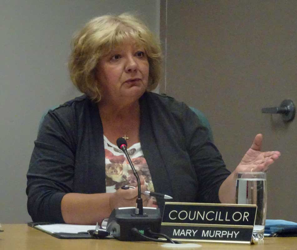
That vote came after council split five to two  again to defeat a motion by Councillor Mary Murphy to stop riverside camping altogether.

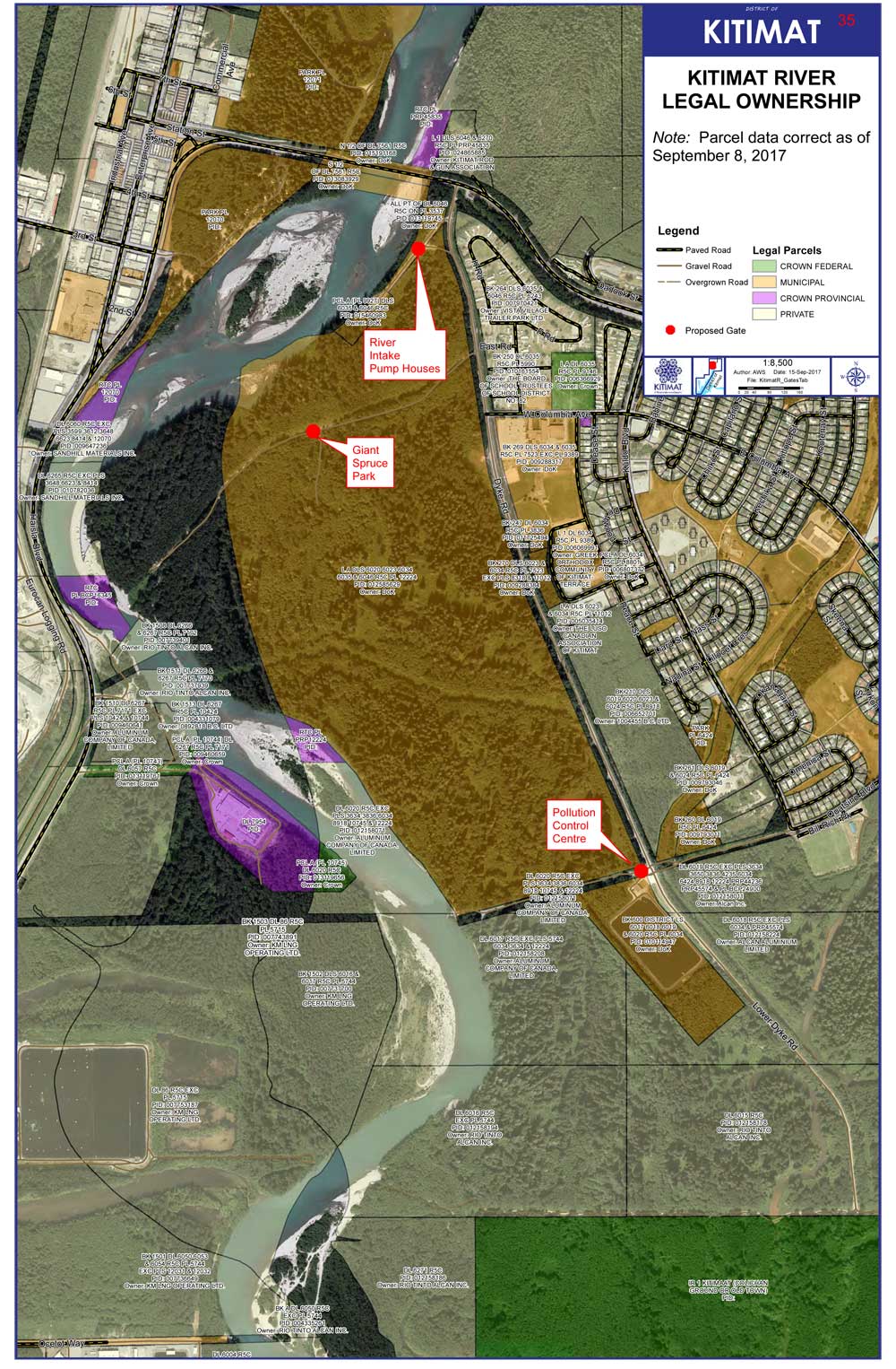
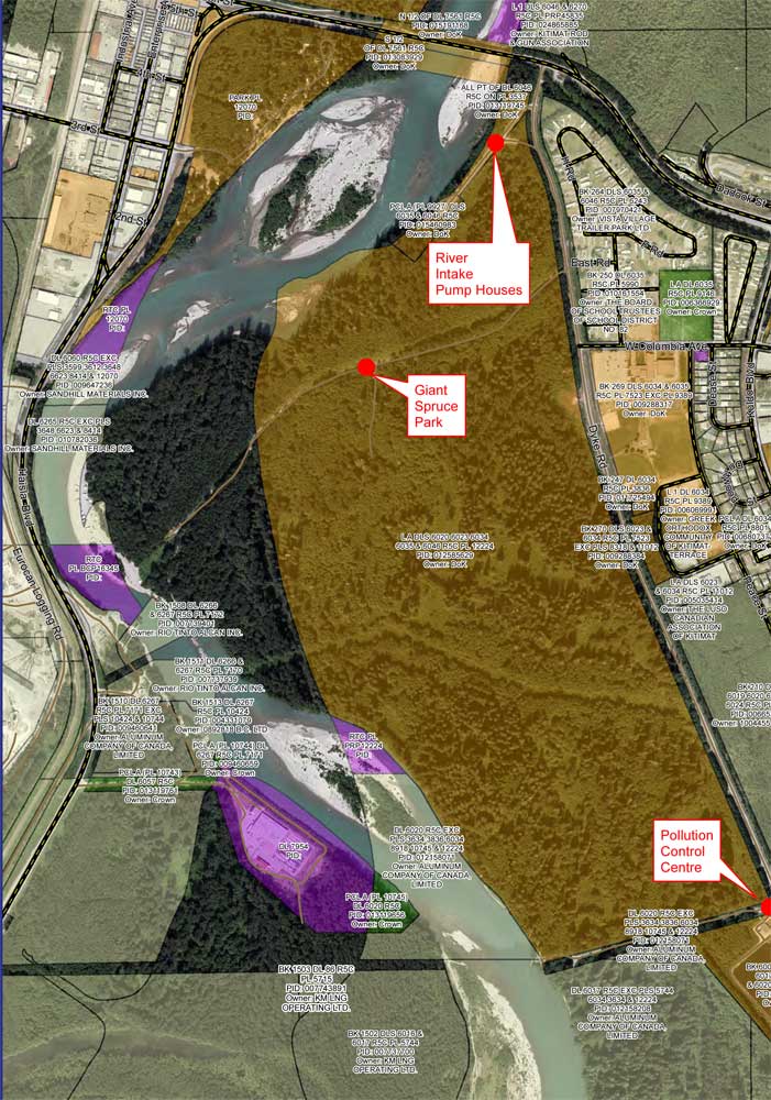
A proposal from District staff to put access gates at three locations, the Giant Spruce Road, the Sewage Plant and the Pump House was tabled for the time being. However, the councilors and staff marked the pump house gate as a priority for study by the engineering staff due to concerns that “the risk of fuel, oil and other contaminants (i.e. Illegal dumping ) occurring. This is the source water area for the city’s water supply, reducing access reduces contamination risks.” Staff said that unlike other portions of the riverbank, the District does “have authority under drinking water protection act to protect this area.”

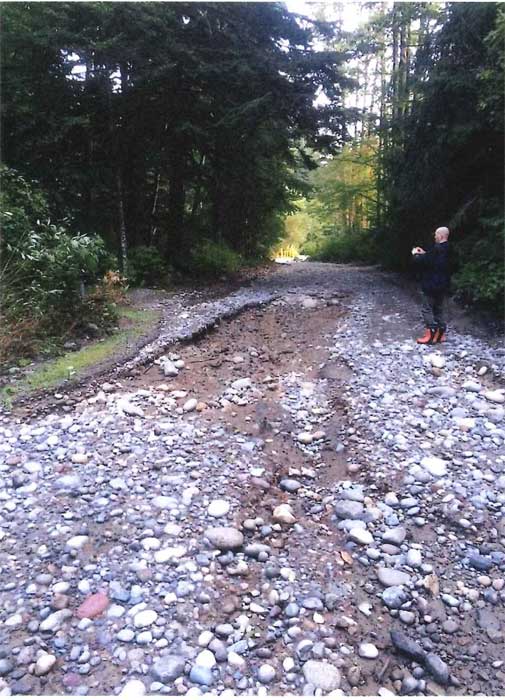
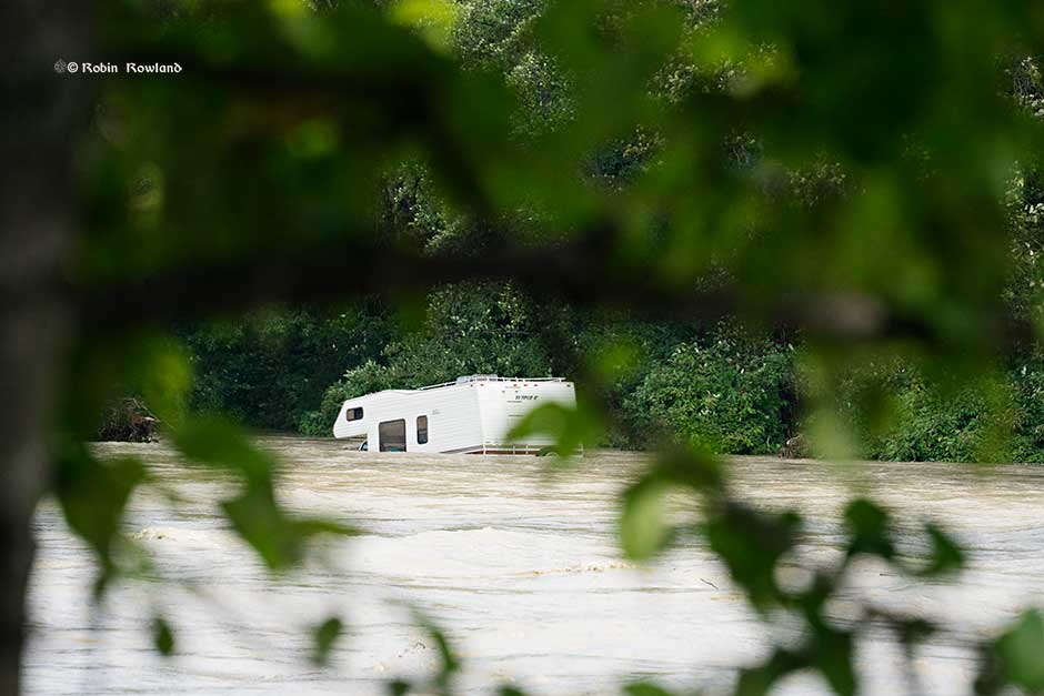
Council also voted to close Hirsh Creek park immediately because the roads at the camping area were washed out by the flood last week.

Councillors noted that many people still go to Hirsch Creek after the gates are closed at the end of the season to walk dogs or hike. This results in a parking jam at the front of the gate and on busy times, cars park on Highway 37 which could endanger pedestrians.

District staff will study moving the park gate down further to a point that the road narrows near the first campsite to allow safe access for dog walkers and hikers.

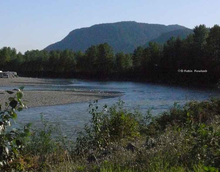
The main problem facing the District of Kitimat is that most popular sites along the riverbank for campers are on provincially owned Crown land. In 2014, the former BC Liberal government passed a regulation that says people can camp on Crown land for up to 14 days. As some councillors pointed out this restriction regularly abused by some campers who stay on the riverbank for weeks, some apparently camping from Victoria Day to Labour Day.

A detail from the DoK map of who owns the riverbank shows that many of the popular camping sports along the Kitimat River are on provincial Crown land (dark green) while the municipality controls the land away from the riverbank including the access roads (brown). (District of Kitimat)

During the debate it was pointed out that often those camp on the riverbank like to “claim” a camping/fishing spot and try to prevent others from using it. “I know of a couple of fistfights,” Murphy told Council.

As Councillor Rob Goffinet pointed out, whether or not the District could place gates on municipal land to stop access to provincial Crown land would require a legal opinion.

Murphy told Council that she had received emails, blaming Kitimat for “almost drowning” some of the campers. She said that her views may be unpopular among some residents, but added, “I don’t care if I’m unpopular, I want to keep people safe.”

Councillor Larry Walker, who pointed out that he likes of fish along the river, who supported Murphy’s motion told his colleagues to get their act together and “do something about the riverbank.” He later proposed that if council does nothing, perhaps Kitimat should hold a referendum on the future use of the river bank.

The majority on Council were more cautious, while acknowledging problems. They pointed out that the many of the campers both on the east bank and on the west bank at Radley Park patronize local businesses during the summer months.

While there was wide discussion on social media before the council meeting, only three people showed up to give their opinions, mostly concerned about permitting access to the river for people with mobility issues or small children.

There were many comments and questions about how other areas police provincial Crown Land, with some saying that some places restrict access to only a couple of days. However, no one either on Council or staff had any idea of what exactly other locations are doing, if anything.

There were no details of how the working group would operate and who would participate. During the debate it was pointed out that as well as the province, participants would have to include Rio Tinto, LNG Canada and DFO. As well, Council did not set a deadline for the working group to report back.

As Murphy pointed out back in 2014, Fisheries and Oceans refused to attend a Council meeting or make a public presentations on its views of the river bank situation. (DFO snubs District of Kitimat Council for a second time )  while offering to meet with staff “they will continue to meet at an operational level to provide information on DFO’s regulatory role.”  That, of course came during the Stephen Harper administration which severely restricted any public participation by the civil service on environmental issues. Whether the Justin Trudeau government has changed that policy remains to be seen.

The campsite road at Hirsch Creek park was washed out in the flood. (District of Kitimat)

Was the rain storm an anomoly?

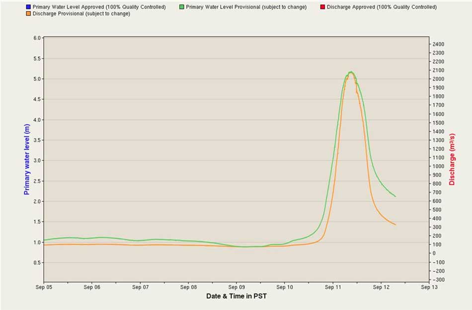
During the debate, Mayor Phil Germuth, pointed to the sudden onslaught of rain during Sunday and Monday September 10 and 11 and called it “an anomaly” which means that Kitimat should not overreact to the storm.

Environment Canada chart of the spike in the Kitimat River levels, as presented to District Council. (Environment Canada)

However, as The New York Times pointed out after Hurricane Harvey hit Texas, scientists have been warning for years that

Climate science has repeatedly shown that global warming is increasing the odds of extreme precipitation and storm surge flooding. Refusing to acknowledge this impairs our ability to prepare for future extreme weather and endangers American lives and property.

And another opinion article in the Times during Hurricane Harvey noted:

Scientists can now even evaluate how much climate change has increased the odds of individual extreme events, including rainfall and flooding.

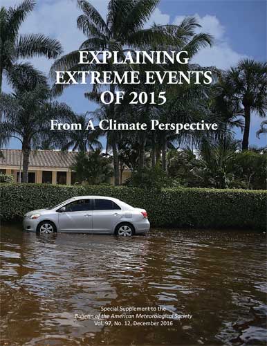
As the 2015 American Meteorological Society report quoted by The Times indicates, those  unpredictable and extreme events don’t just include floods but the widespread forest fires in Alaska in 2014 and we all know how bad the fire season has been in British Columbia this year.

Report on extreme weather events

As Noah Diffenbaugh  of Standford University pointed out in The Times

Being smart about managing exposure and vulnerability is critical to reducing risks. But doing so requires acknowledging that global warming is happening, that humans are the primary cause and that the odds of catastrophes like Hurricane Harvey are increasing.

District clarifies who owns the riverbank, will debate shutting off vehicular access at Monday’s meeting

The District of Kitimat has issued a map clarifying just who owns the banks of the Kitimat River, a subject that has been debated for years, as campers have come and gone as they please.

The map issued by the District staff shows that the District of Kitimat has jurisdiction over much of the land on the east side of the river while Rio Tinto owns much of the western bank–but also does own some of the eastern bank in the lower levels.

District staff are recommending that gates be installed in three areas along the eastern bank on municipally owned land, at the Giant Spruce Road, at the Pump House and at the Sewage plant. That could cut off vehicular traffic while still allowing access for pedestrians and those who wish to fish on the river bank by getting access on foot.

The proposed locations of the gates are marked in red on the map.


Map showing who owns the riverbank lands with the proposed gates marked by red dots. (District of Kitimat)

You’ll find a larger version of the map, and staffs’ recommendations to District Council in the report.

DistrictofKitimatriverbankreport (pdf)


BC launching major study of Kitimat River, Kitimat Arm water quality

The Environmental Protection Division of BC’s Ministry of Environment is launching a major study of the water quality in the Kitimat valley, first on the Kitimat River and some of its tributaries and later on the Kitimat Arm of Douglas Channel.

There has been no regular sampling by the province in Kitimat since 1995 (while other organizations such as the District of Kitimat have been sampling).

Jessica Penno, from the regional operations branch in Smithers, held a meeting for stakeholders at Riverlodge on Monday night. Among those attending the meeting were representatives of the District of Kitimat, the Haisla Nation Council, LNG Canada, Kitimat LNG, Rio Tinto BC Operations, Douglas Channel Watch, Kitimat Valley Naturalists and the Steelhead Society.

As the project ramps up during the spring and summer, the ministry will be looking for volunteers to take water samples to assist the study. The volunteers will be trained to take the samples and monitored to insure “sample integrity.” Penno also asked the District, the Haisla and the industries in the valley to collect extra samples for the provincial study and to  consider sharing historical data for the study.

With the growing possibility of new industrial development in the Kitimat valley, monitoring water quality is a “high priority” for the province, Penno told the meeting. However, so far, there is no money targeted specifically for the project, she said.

Fishing and camping on the Kitimat River
Camping and fishing on the Kitimat River. (Robin Rowland/Northwest Coast Energy News)

The purpose of the study is to make sure water in the Kitimat valley meet the provinces water quality objectives, which have the aim of watching for degradation of water quality, upgrade existing water quality or protect for designated uses such as drinking water, wildlife use, recreational use and industrial water supplies as well as protecting the most sensitive areas. It also provides a baseline for current and future environmental assessment. (In most cases, testing water quality for drinking water is the responsibility of the municipalities, Penno said.  The province may warn a municipality if it detects potential problems, for example if a landslide increases metal content in a stream).

Under the BC Environment system, “water quality guidelines” are generic, while “water quality objectives” are site specific.

One of the aims is to compile all the studies done of the Kitimat River estuary by the various environmental impact studies done by industrial proponents.

The ministry would then create a monitoring program that could be effectively shared with all stakeholders.

At one point one member of the audience said he was “somewhat mystified” at the role of Fisheries and Oceans in any monitoring, noting that “when you phone them, nobody answers.”

“You mean, you too?” one of the BC officials quipped as the room laughed.

Water quality objectives

The last time water quality objectives were identified for the Kitimat River and arm were in the late 1980s, Penno told the meeting. The objectives were developed by the British Columbia government because of potential conflict between fisheries and industry at that time. The objectives were developed for the last ten kilometres of the Kitimat River and the immediate area around the estuary and the Kitimat Arm. “The Kitimat is one of the most heavily sport fished rivers in Canada,” she said.

However, the work at that time was only provisional and there was not enough water quality monitoring to create objectives that could be approved by the assistant deputy minister.

There has been no monitoring of the Kitimat River by BC Environment since 1995. “We’ve had a lot of changes in the Kitimat region, with the closure of Methanex and Eurocan, the modernization of Rio Tinto and potential LNG facilities.”

The main designated uses for the Kitimat River at that time were aquatic life, wildlife with secondary use for fishing and recreation.

She said she wants the stakeholders to identify areas that should be monitored at first on the river and the tributaries. Later in the summer, Environment BC will ask for suggestions for the estuaries of the Upper Kitimat Arm.

Participants expressed concern that the water supply to Kitamaat Village and the Kitimat LNG site at Bish Cove as well as Hirsch Creek and other tributaries should be included in the study. Penno replied that the purpose of the meeting was to identify “intimate local knowledge” to help the study proceed.

After a decade so of cuts, the government has “only so much capacity,” Penno said, which is why the study needs the help of both Kitimat residents and industry to both design the study and to do some of the sampling.

The original sampling station in the 1980s was at the Haisla Boulevard Bridge in Kitimat. A new sampling station has been added at the “orange” Kitimat River bridge on Highway 37. There is also regular sampling and monitoring at Hirsch Creek. The aim is to add new sampling points at both upstream and downstream from discharge points on the river.

The people at the meeting emphasized the program should take into consideration the Kitimat River and all its tributaries—if budget permits.

Spring freshette

Last year, the team collected five samples in thirty days in during four weeks in May and the first week in June, “catching the rising river quite perfectly” at previously established locations, at the Haisla Bridge and upstream and downstream from the old Eurocan site as well as the new “orange bridge” on the Kitimat River.

The plan calls for five samples in thirty days during the spring freshette and the fall rain and monthly sampling in between.

The stakeholders in the meeting told the enviroment staff that the Kitimat Valley has two spring freshettes, the first in March during the valley melt and later in May during the high mountain melt.

The plan calls for continued discussions with the industry stakeholders, Kitimat residents and the Haisla Nation.

The staff also wants the industrial stakeholders to provide data to the province, some of it going back to the founding of Kitimat if a way can be found to make sure all the data is compatible. One of the industry representatives pointed out, however, that sometimes data is the hands of contractors and the hiring company may not have full control over that data.

There will be another public meeting in the summer, once plans for sampling in the Kitimat Arm are ready.

DFO snubs District of Kitimat Council for a second time


Fishing and camping on the Kitimat River
Camping and fishing on the Kitimat River. (Robin Rowland/Northwest Coast Energy News)

Fisheries and Oceans has once again snubbed District of Kitimat Council, by refusing to appear in public before council to answer questions about key issues.

At the Monday, March 10 council meeting, the snub was on the issue of who is responsible for the Kitimat River, facing “increased usage of the riverbank during future construction periods” as well as concerns raised by council earlier over waste left by campers.

In the fall, DFO also refused to appear before council when the department was asked to do so on the issue of Clio Bay remediation.

A report to Council from the District’s Deputy Administrative Officer, Warren Waycheshen, noted that district administration “was recently advised that Fisheries and Oceans are unable to participate in Council meetings, however, they will continue to meet at an operational level to provide information on DFO’s regulatory role.

Waycheshen’s report noted” “District Staff will continue to correspond with Fisheries and Oceans on riverbank camping, and when another operational meeting can be coordinated, Council will be advised of the date and time.”

In other words, DFO officials will continue to meet with district staff and council, in private, but are not accountable to the Kitimat public for their actions, except through what district staff may report to council.

The rest of the report consisted of quotes form the amended Fisheries Act and what appears to be a printout of a DFO Power Point presentation on how it sees its current role.

So now that the federal government appears to have downloaded responsibility to the District, the riverbank ball is now in the hands of Kitimat Council, whether or not the Council actually has jurisdiction.

Councillor Phil Germuth presented a motion asking that District staff prepare a map showing who exactly owns the land along the Kitimat River and what that land is being used for.

In the debate, Councillor Corrine Scott noted, “The first paragraph says Fisheries and Oceans won’t attend a council meeting. Fine, we’ve got that part. But then that’s it. Everything else is about the fisheries protection program and policy statements and all the rest of it. But it doesn’t actually answer the question about any concerns regarding waste left by campers and whether its okay or whether we should be putting in more garbage cans or that sort of thing.

“That’s what I was looking for from a report. What should the setbacks be? Should there be any setbacks. Should there be any camping? Do we have to have a certain number of receptacles for garbage? I just don’t know. I was expecting more than what we got out of this report.”

Councillors Mary Murphy and Mario Feldhoff noted that the District has done reports on how the riverbank is used.

District Planner Daniel Martin told Council that DFO has said the department has “no real concerns’ about people camping on the river “unless they begin to destroy fish habitat.” DFO told Kitimat staff. “If the District has concern about access to the river, then control access to the river.”

“I know that we have a report, it was a very, very good report,” Scott then said. “That’s not what we’re talking about. I was waiting to hear what Fisheries and Oceans has to say, I know what we’ve got and what we’re doing and what is being monitored. I thought motion was to find out from Fisheries and Oceans if there was some kind of other issues we should know about.” Scott noted that if Martin’s statement had been included in the report, she would have been satisfied. “I was waiting to hear what the Department of Fisheries and Oceans had to say.”

Germuth then pointed out that he wanted to know who the landowners are so if Council descies to  control access to the river because, “If we put a gate up on the river, we’re not just controlling access for campers, we’re controlling access for everyone else that wants to go through. I want to know who owns the land, so if we decide to do something, we can chat with landowners.

“We’re not going to get anywhere with DFO,” Feldhoff said. “They’ve been here in the past, and , as I recall, they said they don’t think there is a problem. We may think there’s a problem but they don’t think it’s high enough in terms of priorities. So we might want to reacquaint ourselves with what was going on. There are enough reports to choke a horse, going back at least ten years.”

“Longer that that, I do believe,” Mayor Joanne Monaghan interjected.

Councillor Edwin Empinado agreed with Scott saying, “The response from DFO didn’t really answer the motion [the original question from Council]. Fisheries just gives us the Fisheries Act, their policies, regulations, guidelines, program changes. It doesn’t talk about riverbanks.”

Germuth’s motion was carried unanimously.


SFU study says spill hazards for Kitimat from tankers and pipelines much greater than Enbridge estimate

A study by two scholars at Simon Fraser University says that the Enbridge Northern Gateway project is much more hazardous to Kitimat harbour, Douglas Channel and the BC Coast than Enbridge has told the Joint Review Panel.

The study by Dr. Thomas Gunton, director of the School of Resource and Environmental Management at SFU and Phd student Sean Broadbent, released Thursday May 2, 2013 says there are major methodological flaws in the way Enbridge has analyzed the risk of a potential oil spill from the bitumen and condensate tankers that would be loaded (bitumen) or unloaded (condensate) at the proposed terminal at Kitimat.

Enbridge Northern Gateway responded a few hours after the release of the SFU study with a statement of its own attacking the methedology used by the two SFU scholars and also calling into question their motivation since Gunton has worked for Coastal First Nations on their concerns about the tanker traffic.

Combination of events

One crucial factor stands out from the Gunton and Broadbent study (and one which should be confirmed by independent analysis). The two say that Enbridge, in its risk and safety studies for the Northern Gateway project and the associated tanker traffic, consistently failed to consider the possibility of a combination of circumstances that could lead to either a minor or a major incident.

Up until now, critics of the Northern Gateway project have often acknowledged that Enbridge’s risk analysis is robust but has consistently failed to take into consideration the possibilty of human error.

As most accidents and disasters happen not due to one technical event, or a single human error, the SFU finding that Enbridge hasn’t taken into consideration a series of cascading events is a signficant criticism.

Overall the SFU study says there could be a tanker spill every 10 years, not once in 250 years, as calculated by Enbridge.

It also says there could be 776 oil and condensate spills from pipelines over 50 years, not 25 spills over 50 years as projected by Enbridge. (And the life of the project is estimated at just 30 years, raising the question of why the 50 year figure was chosen)

Enbridge track record

The study also bases its analysis of the possibility of a spill not on Enbridge’s estimates before the Joint Review Panel but on the company’s actual track record of pipeline spllls and incidents and concludes that there could be between one and 16 spills (not necessarily major) each year along the Northern Gateway pipeline.


Findings for Kitimat

Among the key findings for Kitimat from the SFU study are:

  • Enbridge said the possibility of tanker spill was 11.3 to 47.5 per cent over the 30 year life of project. The SFU study says the possibility of a spill within the 30 years is 99.9 per cent.
  • The SFU study says it is likely there will be a small spill at the Kitimat Enbridge terminal every two years.
  • The SFU study estimates that there will be eight tanker transits each week on Douglas Channel if the Northern Gateway project goes ahead and more if it is expanded.  (This, of course, does not include LNG tankers or regular traffic of bulk carriers and tankers for Rio Tinto Alcan)
  • The SFU study says that while Endridge did study maneuverability of tankers, it paid little attention to stopping distance required for AfraMax, SuezMax tankers and Very Large Crude Carriers.
  • The SFU study says Enbridge inflated effectiveness of the proposed tethered tugs and maintains the company did not study ports and operations that use tethered tugs now to see how effective tethering is.
  • The SFU says Enbridge’s risk analysis covered just 233 nautical miles of the British Columbia coast, where as it should have covered entire tanker route both to Asia and California, raising the possibility of a tanker disaster outside British Columbia that would be tied to the Kitimat operation.
  • Based on data on tanker traffic in Valdez, Alaska, from 1978 to 2008, the SFU study estimates probability of a 1,000 barrel spill in Douglas Channel at 98.1 per cent and a 10,000 barrel spill at 74.2 per cent over 30 year Gateway life. The Valdez figures account for introduction of double hulls after Exxon Valdez spill in 1989 and notes that spill frequency is much lower since the introduction of double hulled tankers.
  • According to a study by Worley Parsons for Enbridge in 2012, the Kitimat River is the most likely area affected by an unconstrained rupture due to geohazards in the region. According to the Worley Parsons study, geohazards represent the most significant threat to the Northern Gateway pipeline system.

Flawed studies

The SFU scholars list a series of what they say are major methological or analytic flaws in the information that Enbridge has presented to the Joint Review Panel, concluding that “Enbridge significantly understates the risk of of spills from the Northern Gatway.

Enbridge’s spill risk analysis contains 28 major deficiencies. As a result of these deficiencies, Enbridge underestimates the risk of the ENGP by a significant margin.
Some of the key deficiencies include:

  • Failure to present the probabilities of spills over the operating life of the ENGP
  • Failure to evaluate spill risks outside the narrowly defined BC study area
  • Reliance on LRFP data that significantly underreport tanker incidents by between 38 and 96%.
  • Failure to include the expansion capacity shipment volumes in the analysis
  • Failure to provide confidence ranges of the estimates
  • Failure to provide adequate sensitivity analysis
  • Failure to justify the impact of proposed mitigation measures on spill likelihood
  • Potential double counting of mitigation measures
  • Failure to provide an overall estimate of spill likelihood for the entire ENGP
  • Failure to disclose information and data supporting key assumptions that were used to reduce spill risk estimates
  • Failure to use other well accepted risk models such as the US OSRA model


SFU reports that Enbridge provides separate estimates of the likelihood of spills for each of the three major components of the project:

      • tanker operations,
      • terminal operations,
      • the oil and condensate pipelines.

The SFU scholars say Enbridge does not combine the separate estimates to provide an overall estimate of the probability of spills for the entire project and therefore does not provide sufficient information to determine the likelihood of adverse environmental effects……

It notes that “forecasting spill risk is challenging due to the many variables impacting risk and the uncertainties in forecasting future developments affecting risk. To improve the accuracy of risk assessment, international best practices have been developed.”

Part of the problem for Enbridge may be that when the company appeared before the Joint Review Panel it has repeatedly said that will complete studies long after approval (if the project is approved), leaving large gaps in any risk analysis.

The SFU study may have one example of this when it says Enbridge did not complete any sensitivity analysis for condensate spills at Kitimat Terminal or the condensate pipeline.

Enbridge response

Enbridge responded by saying

Our experts have identified a number of omissions, flawed assumptions and modeling errors in the study and have serious concerns with its conclusions:
The spill probability numbers are inflated: The author uses oil throughput volumes that are nearly 40 per cent higher than those applied for in this project which also inflates the number of tanker transits using these inflated volumes
The pipeline failure frequency methodology adopted by Mr. Gunton is flawed, and does not approximate what would be deemed a best practices approach to the scientific risk analysis of a modern pipeline system
Mr. Gunton based his failure frequency analysis on a small subset of historical failure incident data. Why would he limit the source of his data to two pipelines with incidents not reflective of the industry experience and not reflective of the new technology proposed for Northern Gateway?
The study results are not borne out by real world tanker spill statistics. Based on Mr. Gunton’s estimates we should expect 21 to 77 large tanker spills every year worldwide while in reality after 2000 it has been below 3 per year and in 2012 there were zero.

Most of Enbridge’s rebuttal is a personal attack on Gunton, noting

We are very concerned about the misleading report released by Mr. Gunton, who was a witness for the Coastal First Nations organization during the Northern Gateway Joint Review Panel process.
Mr. Gunton should have made his study available to the JRP process, the most thorough review of a pipeline that’s ever taken place in Canada. All of Northern Gateway’s conclusions have been subject to peer review, information requests and questioning by intervenors and the Joint Review Panel.

In response, Gunton told the Globe and Mail “the report took over a year to complete and it was not ready in time to be submitted as evidence before the federal Joint Review Panel which is now examining the proposed pipeline.”

Enbridge’s statement also ignores the fact under the arcane rules of evidence, any study such as  the  one from Simon Fraser had to be submitted to the JRP early in the process, while evidence was still being submitted.

The recent ruling by the JRP for closing arguments also precludes anyone using material that was not entered into evidence during the actual hearings.

That means that the SFU study will be ignored in the final round of the Joint Review Panel, which can only increase the disillusionment and distrust of the process that is already common throughout northwest British Columbia.