Did the 1964 tsunami bring a dangerous tropical fungus to the BC Coast?

In 1999, a tropical fungus called by scientists Cryptococcus gattii unexpectedly appeared on Vancouver Island. Spores from the fungus can cause a sometimes fatal pneumonia-like illness in humans, cats, dogs and marine mammals, including porpoises and dolphins. There is one reported case of the fungus infecting a great blue heron.

Normally, the fungus is most common in Papua New Guinea, Australia and South America. Today it is also found growing in the coastal forests and shoreline areas of southern coastal British Columbia, Washington and Oregon.

A study, released today, supported by the US Centres for Disease Control and Prevention (CDC) is described as tracking multiple pieces of a puzzle. It suggests that a singular event, like a natural disaster, could have been the missing piece that brought the whole picture together.

The scientists, microbiologist Arturo Casadevall, MD, PhD, Chair of Molecular Microbiology and Immunology at the Bloomberg School at Johns Hopkins University, and epidemiologist David Engelthaler, PhD, of the Translational Genomics Research Institute, Flagstaff, Arizona, suggest that a series of events brought the fungus to BC culminating in its possible spread by the tsunami unleashed by the 1964 magnitude 9.2 earthquake in Anchorage, Alaska. The scientists wrote that the tsunami idea seemed to fit the “when, where, and why” of this disease emergence.

The US CDC has tracked more than 300 C. gattii fungal infections in the Canadian and U.S. Pacific Northwest region since the first case on Vancouver Island in 1999. Prior to that time, infections with this fungus had been confined almost entirely to Papua New Guinea, Australia, and South America. The fungus typically infects people through inhalation. It can cause a pneumonia-like illness, and may also spread to the brain, causing a potentially fatal meningoencephalitis. Although the disease is fairly rare and few infected people become ill, for those who become infected, published case reports suggest an overall mortality rate of more than 10 percent.

Incidence of Cryptococcus gattii infection in BC (BCCDC)

The British Columbia Centre for Disease Control (BCCDC) says Vancouver Island has one of the highest rates of infection in the world. Each year in B.C. from 10 to 25 people become sick from cryptococcosis and about 16 per cent die from the disease.

In the Northern Health region, however, only one case, in 2017, has been reported since 2009 and that was in the Northern Interior region.
The BCDC says the fungal infection can take several months to incubate after exposure. Only a few people exposed to the spores will become ill. Cryptococcus gattii is a reportable disease in British Columbia.

The new study is suggesting that the fungus first traveled in ships’ ballast tanks. After the Panama Canal opened in 1914, shipping increased significantly between Atlantic and Pacific ports.

The scientists believe that in South America, the fungus began washing from local rivers into shore waters. Then ships loaded ballast water, which research has shown is a common mode of transport for invasive species. The ballast water then spread the fungus to North American waters. Ships in those days routinely took on such ballast water in one port and simply discharged it, without treatment, in another.

How the tropical pathogen established itself in such a cool northern area was originally unclear. Theories have included global warming and the import of tropical eucalyptus trees.

The new study proposes that once in the North Pacific the fungus went unnoticed until the 1964 earthquake brought the fungus widely ashore and into coastal forest area.

It then took several decades for the fungus to evolve in its new habitat so that it could survive and then thrive first in coastal Vancouver Island, then across the island to the Lower Mainland and down to Washington and Oregon.

Casadevall says, “The big new idea here is that tsunamis may be a significant mechanism by which pathogens spread from oceans and estuarial rivers onto land and then eventually to wildlife and humans, If this hypothesis is correct, then we may eventually see similar outbreaks of C. gattii, or similar fungi, in areas inundated by the 2004 Indonesian tsunami and 2011 Japanese tsunami.”

The Alaskan Earthquake was felt as far as 4,500 kilometres away. Effects were recorded on the Hawaiian Islands. The waves reported in nearby Shoup Bay, Alaska were 67 metres causing significant shoreline devastation. At Seward, Alaska, the tsunami wave was 9.2 metres. At Port Alberni it was 6.4 metres. North of Kitimat, at Ketchikan, the wave was just 0.6 metres and at Prince Rupert, 1.4 metres. There are no figures for Kitimat, but with no damage reported, it is likely that the wave was somewhere around a metre.

The tsunami continued south, affecting much of the coastline of western North America, even causing several deaths on the beaches of northern California.

Several hours after the earthquake, multiple waves flowed up Alberni Inlet, cresting at eight metres and striking the Port Alberni region, washing away 55 homes and damaging nearly 400 others

The study retrieved multiple fungus samples from the forests in the Port Alberni region. Studies show there are multiple infected sea mammals in the port’s waterways. Human and terrestrial and marine animal cases have also been reported along the western coast of Vancouver Island. The results suggest that the contamination of the Port Alberni region may be from the 1964 tsunami rather than from terrestrial dispersal from the eastern side of Vancouver Island.

Map showing where the 1964 tsunami could have deposited the fungus (Ecological and Evolutionary Science)

The early environmental analyses in British Columbia identified that the fungus was found in soils and trees in the coastal Douglas fir forests and in coastal Western Hemlock forests bordering the coastal Douglas fir forest. While these studies were “limited in geographical space” the contaminated landscapes were also the known locations of human and animal infections. Further ecological analyses have identified higher levels of soil and tree contamination at low-lying elevations close to sea level.

The researchers now hope to continue testing their hypothesis with detailed analyses of C. gattii in soils within and outside tsunami-inundated areas of the Pacific Northwest. They then want to compare the British Columbia fungus with DNA collected from other parts of the world.–to see if the same C. gattii subtypes found in Brazil and the Pacific Northwest are more widely present in seawaters around ports.

The paper: “On the emergence of Cryptococcus gattii in the Pacific Northwest: ballast tanks, tsunamis and black swans” by David Engelthaler and Arturo Casadevall is in the journal Ecological and Evolutionary Science

BCDC defintion
Cryptococcus is a tiny (microscopic) yeast-like fungus. A species of this fungus, called Cryptococcus gattii, has been living on trees and in the soil on the east coast of Vancouver Island since at least 1999. More recently it has also been found in the Vancouver Coastal and Fraser Health regions. Infrequently, people and animals (e.g. cats, dogs, llamas, porpoises) exposed to this fungus become sick with cryptococcal disease (or cryptococcosis). Cryptococcosis can affect the lungs (pneumonia) and nervous system (meningitis) in humans. It affects people with healthy and weakened immune system. In rare cases, this disease can be fatal.

Many people will be exposed to the fungus sometime during their lives and most of these will not get sick. In people who become ill, symptoms appear many months after exposure.

Symptoms of cryptococcal disease include:

Prolonged cough (lasting weeks or months)
Shortness of breath
Headache
Vomiting
Fever
Weight loss
If symptoms occur, the disease can cause pneumonia, meningitis, nodules in the lungs or brain, or skin infection.

People are advised to see their doctor if they live in or visit an area where the fungus can be found and experience these symptoms.

Analysis:   New scientific findings likely confirm Haisla story of first arrival in the valley

Two related scientific papers published in the past two weeks, one on the First Peoples  initial settlement of coastal  North America and the second  giving a probable new timeline of the retreat of the glaciers during the last Ice Age,  taken together  are likely confirmation of the Haisla story of how that nation first settled the Kitimat Valley.

Haisla NationAs related in Gordon Robinson’s Tales of the Kitamaat, the First Peoples living on the coast of what is now British Columbia ventured up what is now called Douglas Channel perhaps from either Bella Bella in Heiltsuk traditional territory or from Prince Rupert in Tsimshian traditional territory.

The young men on the expedition up the Kitimat Arm spotted what they thought was a huge monster kilometres ahead with a large mouth that was constantly opening and closing. The sight was so terrifying that the men fled back to their homes and dubbed the Kitimat Arm as a place of a monster.

Later a man named Hunclee-qualas accidentally killed his wife and had to flee from the vengeance of his father-in-law.   Knowing he had to find a place where no one could find him,  he ventured further up the Kitimat Arm. There he discovered that the “monster” was nothing more than seabirds, probably seagulls, perhaps feasting on a spring oolichan run.

He settled along the shore of what is now the Kitimat River and found a land of plenty, with fish, seals, game as well as berries and other natural products of the land.  Eventually he invited others to join him, which began the Haisla Nation and he became their first chief.

Let’s examine the new evidence so far.

  1. Settlement along the coastal “kelp highway” between 18,000 and 16,000 years ago, followed by a warm spell 14,500 years ago

It’s now fairly certain that the First Peoples first began to settle along the coast by following the “kelp highway” perhaps as early as 18,000 years ago and certainly by 14,000 years ago.  Haida Gwaii was ice free, except for some mountain glaciation as early as 16,500 years ago.   At about 14,500 years ago there was a warming spell which forced the glaciers to retreat, brought higher sea levels and the arctic like tundra ecosystem would have been replaced, at least for a time, by forests. There is the discovery of a Heiltsuk settlement dated to 14,000 years ago.  At that time almost all of the coast would have been free of glacial ice but there were still glaciers in the fjords, including the Kitimat Arm which would mean there could be no permanent settlement in the “inland coast” and the interior.

(Science)
  1. The cooling period from 14,000 to 11,700 years ago confines settlement to the coast

The cooling periods  (with occasional warmer times) from about 14,000 years ago to about 11,700 years ago meant that settlement would largely have been confined to the coast for about two and half millennia. The culture of the coastal First Peoples would have been well established by the time the glaciers began the final retreat.

(Remember that it is just 2,000 years from our time in 2017 back to the height of the Roman Empire under Augustus Caesar).

It is likely that the cooling periods also meant that some descendants of initial settlers likely headed south for relatively warmer climates. Rising sea levels meant that the initial settlement villages would likely have been abandoned for higher ground.

  1. A second period of rapid warming 11,700 years ago which opens up the interior fjords and valleys

At the end of what geologists call the Younger Dryas period, about 11,500 years ago, the climate warmed, the glaciers retreated further, in the case of Kitimat, first to what is now called Haisla Hill, then to Onion Flats and finally to Terrace.

  1. Large glacial sediment river deltas filled with fresh melt water from retreating ice

The most important confirmation of the story of Hunclee-qualas’s exile is the account  of the monster, the birds and the oolichan run.

The new scientific evidence, combined with earlier studies, points to the fact that the glacial melt water carried with it huge amounts of glacial sediment that created vast river deltas in coastal regions of the Northern Hemisphere.

That means around 10,000 years ago,   when the Kitimat Valley was ice free and the new forest ecosystem was spreading up the valley, the Kitimat River estuary was likely to have been much larger than today.  It could have been a vast delta, which would have quickly been repopulated with fish, including salmon and oolichan. That rich delta ecosystem could have supported a much larger population of seabirds than the smaller estuary in recent recorded history.

Snow geese by the thousands in the Sacramento-San Joaquin Bay Delta/ CrunchySkies/Wikimedia Commons/Creative Commons License

The story of the monster those first travelers saw far off is highly plausible. Even today in huge, rich deltas elsewhere in the world, seeing hundreds of thousands of birds in flight over a wetland is fairly common. (For a description of what a Kitimat River delta may have been like thousands of years ago, see KCET’s story on the Sacramento-San Joaquin Bay Delta and what that delta was like 6,000 years ago)

The First Peoples had had well established communities for up to four thousand years before the Kitimat Valley’s metres of thick ice had melted away.  For the first period, while the ecosystem regenerated, for the people of the coast coming up Douglas Channel to the valley would not have been worth it, there would be little to find in terms of fish, game or forest resources.

A Snow Goose flock near the Skagit River Delta, WA./ Walter Siegmund/Wikimedia Commons
  1. The change from tundra to a rich forest environment

Eventually as the forest regenerated, the streams filled with salmon and oolichan; the bird population including gulls, geese and eagles, found a new feeding ground;  bears, deer and other animals arrived. The Kitimat region would have been an attractive place to explore and hunt. It may be the monster story did keep people away until Hunclee-qualas had to find a place to hide and discovered a new home just at a time that might be called an ecological optimum with new forests stretching back along the valley to what is now Terrace.

  1. The river delta shrinks back to the current estuary

If a vast Kitimat River delta did stretch further down the Channel than it does in 2017, it likely shrank back in the subsequent millennia.   Eventually the mass of glacial sediment that came downstream after the retreat of the ice would diminish, but not stop entirely. The estuary is still rebuilt from sediments washed downstream but that sediment doesn’t match other  rich deltas elsewhere such as the Nile in Egypt.   With that regeneration of the delta slower and smaller than in the first centuries of Haisla settlement, at the same time the land surface rebounded from the weight of the ice, perhaps creating the Kildala neighborhood.  The ocean level rose, drowning and eroding part of the old delta, creating the estuary we know today.


As the authors of the paper on the First Peoples’ settlement note, most of the archaeological evidence of early coastal settlement is now likely many metres below the surface of the ocean but deep ocean exploration may uncover  that evidence.  As the scientific team on the second paper say, they are now working on detailed studies of the glacial retreat from the coastal mountain region which may, when the studies are complete, change the timeline

While waiting for further evidence from archaeology and geology it is safe to say that the stories of the monster and later Hunclee-qualas’s discovery of the Haisla homeland are even more compelling than when Gordon Robinson wrote Tales of the Kitamaat.  We can now speculate that there was once, stretching from Haisla Hill far down the Channel, a vast, varied rich, river estuarine delta that supported hundreds of thousands of seabirds, which if they took the wing in unison, would have made those unwary travelers millennia ago, really think that there was a giant monster waiting to devour them at the head of the Kitimat Arm.


Special Report: New study identifies earthquake hazards for Hartley Bay, Bella Bella, Kitimat and Terrace

UPDATED with comments from District of Kitimat, Terrace and the Gitga’at Nation

A preliminary seismic hazard assessment by Natural Resources Canada has identified possible earthquake scenarios for the Douglas Channel near Hartley Bay, Terrace and Bella Bella.

The same studies indicate that while Kitimat may not be directly in a seismic zone prolonged earthquakes cause some damage in Kitimat depending on the earthquake and the condition of the soil in certain parts of the District. One model scenario says that in the event of a magnitude 8.0 earthquake off the west coast of Haida Gwaii, given certain soil conditions, there might actually be more damage in Kitimat than on the islands.

Susceptibility to landslides

That assessment, part of the overall the study by the Geological Survey of Canada indicates that the north coast of British Columbia from Prince Rupert to Bella Bella is likely face to “seismically induced ground failure”– mostly landslides.

Overall, the report says that on a scale of 1 to 6 (6 representing the highest
susceptibility), the majority of the west coast of BC “exhibits landslide susceptibility values of 5 to 6, which is significantly higher than the rest of Canada.”

Geological Survey of Canada map showing parts of Canada that are prone to landslides. The BC North Coast study area is outlined by the rectangle. (Geological Survey of Canada)

In British Columbia the landslides are most likely to be triggered by delayed melting of the annual snow pack, heavy rains, bank erosion and site loading and caused long-lasting damning of the river causing “damage to pipelines, rail, and forestry, as well as fish habitats.”

So far no recent landslides along the northern British Columbia coast are known to be caused by earthquakes, the reports say “the existence of numerous landslides strengthens the likelihood of seismically induced ground failures… due to the high levels of seismicity….it is expected that the increased likelihood of strong ground shaking (with long durations) will increase the landslide susceptibility.”

New studies

It was only after the 2012 Haida Gwaii earthquake and with what the Geological Survey of Canada calls “a growing number of on-going and planned infrastructure projects, BC’s north coast is emerging as a region of high strategic importance to Canada’s economy,” that studies began in area where “there has been minimal research to understand earthquake hazards.”

Now that studies have begun the Geological Survey has given the region its own new acronym BCNC (BC North Coast). Haida Gwaii is not part of BCNC, although earthquakes on those islands would likely impact the coast.

A Geological Survey of Canada map showing the BC North Coast region with earthquakes identified prior to and during recent studies. (Geological Survey of Canada)

The Geological Survey says that historically “the BCNC has been seismically quiescent.” As a result “seismic monitoring and research related to the BCNC has been minimal.” That meant while larger earthquakes were “felt and recorded,” the configuration of the Canadian National Seismograph Network did not allow earthquakes less than approximately magnitude 2.1 to be monitored in northern BC.

Now the Geological Survey is looking at “long-term, continuous monitoring of micro seismicity, combined with geodetic and paleo seismic techniques” that could be used to study at the possibility of large earthquakes, including a possible fault on the lower Douglas Channel.

Since the studies began in August 2014, the Geological Survey identified 145 earthquakes within the study area, many too small to be felt since they are less than magnitude 2.0. Those earthquakes, however, were picked up by the new and improved instrumentation used by the earthquake monitors.

The two reports one on “seismic hazards” and the second on “geohazards” says five “temporary seismonitors”  (download reports from links below) were installed within the BCNC while some older stations were upgraded, saying, “It is expected that these new stations will be aid in locating small earthquakes” that were not previously detected by the existing network. The Geological Survey also installed ground movement monitoring GPS units along the coast.

The use of the term “temporary” raises the question about how much ongoing monitoring is planned.

The study also notes that the current data is not included in the seismic standards in the current National Building Code of Canada, which in turn is based on the Natural Resources Canada Seismic Hazard Map. That may mean that municipalities in the BC North Coast region, in the future, as the seismic studies continue, may have to consider updating building codes, especially in areas of “softer soils” as opposed to harder rock.

“Fault-like structure” on Douglas Channel

Detail of a map from the Geological Survey of Canada where the red line shows the 60 kilometre possible (still unconfirmed) fault line running from Gribbell Island to Princess Royal Island (Geological Survey of Canada)

Over the years some small earthquakes have also been recorded on what the Geological Survey calls the “recently mapped fault-like structure” on Douglas Channel which was discovered in 2012. The survey is still calling it “fault-like” because it has not yet been confirmed as an active fault. A new map in the study shows that the “fault” runs from the southern tip of Gribbell Island, down the centre of Whale Channel east of Gil Island and then along the western coast of Princess Royal Island.

The study identified “a small, unfelt swarm of earthquakes between magnitude 1.7 and 2.0 between September 13 and 14, 2010 near Gil Island.”

There is also the previously identified ancient Grenville Channel Fault (ancient and believed inactive because it dates from the Cretaceous, the age of the dinosaurs) that runs from along Grenville Channel from Porcher Island in the north to Klemtu in the south which has experienced small earthquakes.

The report says geological studies of the Douglas Channel “fault-like structure” are a priority because, “Should this structure be determined to be an active fault, it would pose significant risk of earthquake-triggered landslides (and subsequent tsunami) from the susceptible Douglas Channel hill slopes.”

Clay and sand in Kitimat

The report also calls for more studies the local geology and soil conditions in the Kitimat Valley. A study back in 1984 by John Clague of Simon Fraser University showed that as the glaciers retreated during the last Ice Age there were “periods of stagnation” resulting in sediments that are thicker than other regions of British Columbia, Clague reported that in parts of Kitimat, the glacial moraine is hundreds of metres thick.

After the glaciers were gone, the sea levels rose and glaciomarine sediments (clay, silt up to 60 metres thick) were deposited until the sea level fell to present-day levels. The report says that as these marine deposits were exposed to fresh water, salts were leached out resulting in saturated, porous sediments, including clay, which are prone to failure. Boreholes in the Kitimat area show that the clay and sediments above the bedrock can range from 17 metres to 106 metres.

The report notes the presence of clay soils “can amplify ground shaking and secondary effects” as happened in November 1988 when there was an earthquake in the Saguenay region of Quebec.

Originally reported as a 6.2 magnitude but later downgraded to 5.9, on Nov. 25, 1988, the major earthquake was centered near the Quebec cities of Chicoutimi and Jonquière, with aftershocks felt as far away as Toronto, Halifax and Boston. The quake lasted for two minutes, catching thousands of people off guard and leaving buildings damaged and power out for hundreds of thousands of Quebecers.

CBC Television reported the earthquake caused a leak of toxic gas at the Alcan Aluminum plant at Jonquière, which was quickly contained. “There was no wind, we were basically lucky,” Alcan spokesman Jacques Dubac told CBC News at the time. 

Terrace earthquake

The report says the most significant event within the BC North Coast study region (which as mentioned doesn’t include Haida Gwaii) was a magnitude 4.9 earthquake approximately 20 kilometers southwest of Terrace on November 5, 1973, which was felt as far as 120 kilometers away, with some minor damage (broken windows and cracked plaster) reported near the epicentre. The main shock at Terrace was preceded by a magnitude 2.5 foreshock four hours before, and followed by a felt magnitude 3.7 aftershock the next day.

Bella Bella at risk

Another area most at risk, according to the report, is southern part of the BC North Coast zone, near Bella Bella, which is close to the northern section  Cascadia Subduction Zone  a “1,000 kilometre long dipping fault that stretches from Northern Vancouver Island to Cape Mendocino California” which one day will cause a major earthquake along the fault.

Cascadia subduction zone (USGS)

The report says that a magnitude 9.0 or higher earthquake in the northern Cascadia Subduction zone close to Bella Bella would be similar to the March 2011 earthquake in Japan and the 1964 Good Friday earthquake in Alaska.

For the northern part of the BC North Coast region, hazards could come from either a major earthquake off Haida Gwaii or a similar earthquake in south-eastern Alaska.

The greatest hazard would come from “long period” earthquakes greater than magnitude 6.75 with an epicentre between 300 and 350 kilometers away where the shaking lasts longer than one second.

The Geological Survey modeled three possible scenarios for major earthquakes in the BC North Coast Region.

Model #1. A magnitude 8.0 Earthquake at Haida Gwaii

The Geological Survey Canada model for an 8.0 magnitude earthquake west of Haida Gwaii. The possible damage is colour coded in the table below the map according to the Modified Mercalli Intensity Scale (Geological Survey of Canada)
The Geological Survey Canada model for an 8.0 magnitude earthquake west of Haida Gwaii. The possible damage is colour coded in the table below the map according to the Modified Mercalli Intensity Scale.  The red polygon represents the area of possible rupture in the model with the star representing the epicentre. (Geological Survey of Canada)

The model looked at a “plausible maximum predicted” magnitude 8.0 thrust fault earthquake off the west coast of Haida Gwaii which would be twice as strong in the fault area as the 7.8 quake on October 28, 2012 (Remember Magnitudes are based on a logarithmic scale. That means for each whole number higher, the amplitude of the ground motion recorded by a seismograph goes up ten times so magnitude 8 earthquake would result in ten times the ground shaking as a magnitude 7 earthquake)

For a short period earthquake, the report estimates that there would be minimal damage on Haida Gwaii similar to the damage from the 2012 earthquake with little or no damage on the BC North Coast.

A long duration, long period earthquake that lasted longer than one second and up to three seconds or longer “may effect taller structures and trigger ground failure (that is liquefaction and lateral shaking).” Kitimat would feel that earthquake with the worst shaking in parts of the District with what the report calls “sensitive soils.” Coastal islands would feel double the amount of shaking as would occur in Kitimat.

Model #2. A magnitude 7.2 Earthquake in Douglas Channel

 The Geological Survey Canada model for a 7/2 magnitude earthquake in the lower Douglas Channel. The possible damage is colour coded in the table below the map according to the Modified Mercalli Intensity Scale. The red star represents the possible epicentre. (Geological Survey of Canada)

The Geological Survey Canada model for a 7/2 magnitude earthquake in the lower Douglas Channel. The possible damage is colour coded in the table below the map according to the Modified Mercalli Intensity Scale. The red star represents the possible epicentre. (Geological Survey of Canada)

The second model looked at an earthquake in Douglas Channel based on the “fault like structure” if a slip strike rupture occurred along the entire 60 kilometers of the so far unconfirmed fault, resulting in a 7.2 magnitude earthquake. There would be very strong shaking within 20 kilometers radius of the epicentre, with moderate to heavy damage” in the relatively uninhabited islands, major shaking in Hartley Bay, resulting in very strong to strong damage at Hartley Bay and strong to moderate damage in Kitimat.

That earthquake, however, would be felt across the entire province of British Columbia. The report notes:

The expected effects and impacts of such an earthquake would mimic those of the 1946 magnitude 7.3 Vancouver Island earthquake, which occurred slightly west of Courtney and Campbell River. Shaking due to the 1946 earthquake was felt as far as Prince Rupert, BC to the north and Portland, Oregon to the south. In addition to knocking down 75 per cent of the chimneys in the local area, much of the earthquake-related damage was due to landslides, slumping and liquefaction

Model #3  A magnitude 6.3 Earthquake near Terrace

 The Geological Survey Canada model for an 6.3 magnitude earthquake southwest of Terrace. The possible damage is colour coded in the table below the map according to the Modified Mercalli Intensity Scale. The red polygon represents the area of possible rupture in the model with the star representing the epicentre. (Geological Survey of Canada)

The Geological Survey Canada model for an 6.3 magnitude earthquake southwest of Terrace. The possible damage is colour coded in the table below the map according to the Modified Mercalli Intensity Scale. The red polygon represents the area of possible rupture in the model with the star representing the epicentre. (Geological Survey of Canada)

On May 11, 1973, a magnitude 4.7 shallow earthquake took place about 20 kilometers south west of Terrace, on the south side of the Skeena roughly across from the Shames mountain area. The earthquake was felt up to 120 kilometers away. The report says “The event has not been associated with any geologic features in the area and little is known about its rupture process.” The model estimated the results of a larger earthquake 6.3 magnitude in the same area. The model showed there would be strong to very strong shaking in Terrace, light to moderate shaking in Kitimat and light damage elsewhere in the BC North Coast. Most of the damage would be concentrated in a 20 kilometer zone around the epicentre.

Motivation for study

It was not just potential industrial development that motivated the new studies. The discovery of that possible fault line in the lower Douglas Channel was also a factor. Studies between 2007 and 2009 revealed there were two large submarine slides on Hawkesbury Island during the mid-Holocene sometime between 5,000 and 10,000 years ago 

The cause of the two failures is still unknown but the report says “their proximity to a nearby unmapped fault-like structure suggests that the slides could have been triggered by strong ground shaking from rupture along this structure.”

Another factor was the two well-known landslides occurred in the 1970’s in the Kitimat Arm which generated tsunamis but fortunately they occurred at low tide which decreased the impact. On October 17, 1974 a submarine slide generated a 2.8 metre tsunami. The following year on April 27, 1975, a slope failure on the northeast side of Kitimat Arm (which overlapped the 1974 failure area) displaced an estimated upper limit of 26,000,000 cubic metres of material.

“Watermark observations in Kitamaat Village estimated that the tsunami generated by this slide was up to 8.2 metres high.” The report says that while the trigger of the first event is unknown; the latter event coincided with nearby construction at that time. Modelling of the 1975 slide estimates that given the right conditions the generated tsunami waves could have been as high as 11 metres.

The report also notes that numerous landslides have also been mapped by the BC Department of Forestry in an attempt to improve safety measures for forestry workers.

The report says “The culmination of these studies brings awareness to the significant natural hazards present in the fragile coastal environment of the Coast Ranges.”

Another factor is the geology of the BC coast. The granitic mountains have rugged, steep slopes dissected by an intricate fjord system and dotted with islands of lower elevation. At lower elevations the land is covered by wet, coastal hemlock forests, which could be vulnerable to ground failures whereas higher elevations are characterized by barren rock or mountain hemlock subalpine.

Table of Seismic monitoring and GPS stations in northern BC from the Geological Survey of Canada (Geological Survey of Canada)

The District of Kitimat said it has “not directly studied these issues but we are aware of potential hazards.” The development department has been advised of potential issues and site concerns.

A spokesperson for Terrace mayor Carol Leclerc told Northwest Coast Energy News in an e-mail. “I have reviewed it and distributed it to the relevant department heads. We are aware that historically Terrace has been at risk for experiencing seismic activity due to its location.”

The District of Kitimat did cooperate with National Resources in finding a location for their recently installed seismic equipment.

At Harley Bay, Gitga’at First Nation CEO Ellen Torng said the Gitga’at have been “ working with NRCan on their research in the Douglas Channel and in Hawksbury. NRC has been meeting with First Nations along the coast and have conducted community sessions on their research.

“We hosted one community session here in Hartley Bay and have regular updates from their technical team when they are in the area,” Torng said.

In addition, the District of Kitimat told Northwest Coast Energy News that Community Planning & Development department also provided local land information to geoscientists in the years leading up an international study called Batholiths on land in 2009.

Batholiths are large zones of molten rock that have solidified in the earth’s crust and are believed to play a key role in the formation and growth of continents. The Coast Mountain Range has a large concentration of batholiths, which means Kitimat was an excellent place to study the earth’s crust.

The project, which involved more than 50 scientists from nine Canadian and American universities, was set up to examine how mountain belts form and change over time and why continental mountain ranges are made of granite not basalt. Seismic imaging of the crust and mantle below the mountains required deploying thousands of seismic sensors and recorders, and recorded responses to several man-made detonations. Field work was completed in July 2009, and several scientific papers and dissertations have followed.

The Heiltsuk Nation was unable to respond to a request for comment due to the ongoing crisis from the sinking of the tug Nathan E. Stewart and the resulting spill of diesel fuel and other contaminants near Bella Bella.

Related Commentary: The earthshaking difference between Enbridge and LNG

Download the Geological Survey Studies (PDF)

Baseline Assessment of Seismic Hazards in British Columbia’s North Coast 2016

North Coast Geohazards 2016 Seismology Update

Modified Mercalli Intensity Scale

(from US Geological Survey )

Intensity Shaking Description/Damage
I Not felt Not felt except by a very few under especially favorable conditions.
II Weak Felt only by a few persons at rest,especially on upper floors of buildings.
III Weak Felt quite noticeably by persons indoors, especially on upper floors of buildings. Many people do not recognize it as an earthquake. Standing motor cars may rock slightly. Vibrations similar to the passing of a truck. Duration estimated.
IV Light Felt indoors by many, outdoors by few during the day. At night, some awakened. Dishes, windows, doors disturbed; walls make cracking sound. Sensation like heavy truck striking building. Standing motor cars rocked noticeably.
V Moderate Felt by nearly everyone; many awakened. Some dishes, windows broken. Unstable objects overturned. Pendulum clocks may stop.
VI Strong Felt by all, many frightened. Some heavy furniture moved; a few instances of fallen plaster. Damage slight.
VII Very strong Damage negligible in buildings of good design and construction; slight to moderate in well-built ordinary structures; considerable damage in poorly built or badly designed structures; some chimneys broken.
VIII Severe Damage slight in specially designed structures; considerable damage in ordinary substantial buildings with partial collapse. Damage great in poorly built structures. Fall of chimneys, factory stacks, columns, monuments, walls. Heavy furniture overturned.
IX Violent Damage considerable in specially designed structures; well-designed frame structures thrown out of plumb. Damage great in substantial buildings, with partial collapse. Buildings shifted off foundations.
X Extreme Some well-built wooden structures destroyed; most masonry and frame structures destroyed with foundations. Rails bent.

Photo gallery: Preparing for the Pacific Trail Pipeline

pipelineslashwedeene1bw

A pile of slash at a quarry site for the Pacific Trail Pipeline near the Little Wedeene River. (Robin Rowland)

Complete photo gallery at my photography site.

Fossil hedgehog, tapir lived in ancient rain forest at threatened Driftwood Canyon Park near Smithers

About 52 million years ago what is now the Bulkley Valley was home to a tiny hedgehog  and an ancient ancestor of tapirs, who lived on the shores of a placid lake surrounded by  a lush upland forest.

The newly discovered fossils at Driftwood Canyon near Smithers are significant advance in the study of the ancient history of the region. That’s because while the Driftwood Canyon Provincial Park is known for beautifully preserved fossils of leaves, fishes and insects, these are the first mammalian remains found at the site.

Eocene lake
An artist’s impression of the 52-million year old early Eocene rain forest around lake in what is now the Bulkley Valley. The tapiroid Heptodon drinks in the shallows, while the small proto-hedgehog Silvacola acares stalks a green lacewing(Pseudochrysopa harveyi). ( Illustration © by Julius T. Csotonyi. used by permission)

The fossil hedgehog and tapir are even more significant because at the time they lived near an upland lake, Earth was going through a period of rapid global warming, now called the Paleocene-Eocene Thermal Maximum.

In the past couple of years, climatologists and paleontologists have started to play closer attention to the Thermal Maximum period in hopes of understanding what could happen during climate change today.

Driftwood Canyon first became famous in 1977 with the discovery of oldest known ancestor of salmons, Eosalmo driftwoodensis, which lived in an  Eocene lake at Driftwood Canyon.

Today’s  study says the ancient hedgehog is a species hitherto unknown to science. It is named Silvacola acares, which means “tiny forest dweller,” since this minute hedgehog likely had a body length of only two to two and half inches or five to six centimetres, about the size of an adult human thumb.

“It is quite tiny and comparable in size to some of today’s shrews,” said Dr. Jaelyn Eberle of the University of Colorado, lead author of the study.   She speculated Silvacola may have fed on insects, plants and perhaps seeds.

Did it have quills like contemporary hedgehogs? “We can’t say for sure,” Eberle said. “But there are ancestral hedgehogs living in Europe about the same time that had bristly hair covering them, so it is plausible Silvacola did too.”

The  delicate fossil jaw of Silvacola was not freed from the surrounding rock as is typical for fossils. Instead it was studied using an industrial high resolution CT (computed tomography) scanner at Penn State University so it could be studied without risking damage to its tiny teeth.

Hedgehogs are no longer found naturally  in North America. Modern hedgehogs and their relatives are restricted to Europe, Asia, and Africa. Hedgehogs have become quite the rage as pets in North America in the past several years. The most common hedgehog pet today is the African pygmy hedgehog, which is up to four times the length of the diminutive Silvacola.

The other mammal, about the size of a medium-sized dog,  discovered at the site, is Heptodon, is an ancient relative of modern tapirs, which resemble small rhinos with no horns and a short, mobile, trunk or proboscis.

Heptodon was about half the size of today’s tapirs, and it lacked the short trunk that occurs on later species and their living cousins. Based upon its teeth, it was probably a leaf-eater, which fits nicely with the rain forest environment indicated by the fossil plants at Driftwood Canyon,”  Eberle said.

Most of the fossil-bearing rocks at Driftwood Canyon formed on the bottom of an ancient lake and are well-known for their exceptionally well-preserved leaves, insects, and fishes.

“The discovery in northern British Columbia of an early cousin to tapirs is intriguing because today’s tapirs live in the tropics. Its occurrence, alongside a diversity of fossil plants that indicates a rain forest, supports an idea put forward by others that tapirs and their extinct kin are good indicators of dense forests and high precipitation,” she said.

Forests, lakes, rivers

Fossil plants from the site indicate the area seldom experienced freezing temperatures and probably had a climate similar to that of Portland, Oregon, located roughly 1,126 kilometres or 700 miles to the south.

The current and previous studies have shown the hedgehog and tapid lived on the shores of a lake surrounded by a mixed conifer-broadleaf forest with redwoods, such as Metasequoia and Sequoia, cedars, fir, larch, golden larch, spruce, pine as well as rare ginkgoes. There were also broadleaf deciduous trees such as alder, birch,  sassafras, elms, and relatives of the oak family. In the lake were Azolla, a floating fern,  which are frequently found as preserved mats in the fossil shale of the cliff at Driftwood, which together with the fine preservation of the insects indicate a quiet water lake.

The remains on the hedgehog were found in the fossil lake bed while the tapir was found in river sediments.

The paleoclimate has been reconstructed suggesting the region had  a mean annual temperature of between 10 degrees C and 15 degrees C, with minimal winter freezing and annual precipitation of about 100 centimetres a year. Today, the mean annual temperature for Smithers is 4.2 degrees C with 50.85 centimetres of precipitation a year

Lost world

“Driftwood Canyon is a window into a lost world – an evolutionary experiment where palms grew beneath spruce trees and the insects included a mixture of Canadian and Australian species. Discovering mammals allows us to paint a more complete picture of this lost world,” said Dr. David Greenwood of Brandon University, a co-author of the study.

“The early Eocene is a time in the geological past that helps us understand how present day Canada came to have the temperate plants and animals it has today. However, it can also help us understand how the world may change as the global climate continues to warm.”

The Driftwood Canyon site is the northernmost of a series of Eocene lake sites spanning about 1000 kilometres that reach south from Smithers to Republic in northern Washington that the scientists call the Okanagan Highlands, with a mixture of temperate and tropical plants and animals and a high diversity of insects and plants.

Looting

While Driftwood Canyon is now among sites considered a key indicator of climate change 50 to 53 million years ago, the Harper government has cut almost all the funding for research into paleontology, not just at Driftwood Canyon but across the country, because looking for fossils doesn’t usually fit into the Conservative policy of only funding science that promotes industry.

“Within Canada, the only other fossil localities yielding mammals of similar age are from the Arctic, so these fossils from British Columbia help fill a significant geographic gap,” said Dr. Natalia Rybczynski of the Canadian Museum of Nature, a co-author of the study.

Other fossils of this age come from Wyoming and Colorado, some 4,345 kilometres or 2,700 miles to the south of the Arctic site of Ellesmere Island. In addition, sources have told Northwest Coast Energy News that the provincial budget for Driftwood Canyon, despite its significance, is the same  as other small parks of that size, with virtually no security to prevent fossils leaving the park, either in the hands of professional looters or if they are picked up and taken home by visitors.

There are consistent reports that looted fossils from Driftwood Canyon are regularly showing up at fossil shows in the United States.

Sources have told Northwest Coast Energy News that the provincial government has ignored requests to improve security at Driftwood Canyon because it is considered a small (just 21 hectares) low priority park off the main tourist routes, rather than a significant fossil site.

The mammal fossils were discovered in 2012 before the budget cuts and are now in the Royal British Columbia museum in Victoria. The fieldwork was supported by Natural Sciences and Engineering Research Council of Canada.

The study “Early Eocene mammals from the Driftwood Creek beds, Driftwood Canyon Provincial Park, Northern British Columbia ” was published in the July 8, 2014 edition of the Journal of Vertebrate Paleontology.

Fossil hunting at Driftwood Canyon
The fossil-bearing sediments at the “North Face” fossil site in Driftwood Canyon Provincial Park near Smithers. The layers of shale are the remains of old lake beds. The grey area near the bottom of the cliff shows where volcanic ash settled on the lake. The scientist in the lower part of the picture are excavating the fossil hedgehog. (Dave Greenwood/Brandon University)

Genetics show stronger pine beetle evolving; stream flow increases in infected forests: studies

A new study, based at the University of Alberta, released this week, indicates that natural selection may be making the mountain pine beetle more tolerant of colder temperatures and that the beetle may be evolving the ability to fly longer distances.

A second study, from the Colorado School of Mines, also released this week, is tracking how the extent of pine beetle infected or killed trees in forests is changing ground water and stream flows.

The mountain pine beetle infestation has wreaked havoc in North America, across forests from the American Southwest to British Columbia and Alberta. Millions of hectares of forest have been lost, with severe economic and ecological impacts from a beetle outbreak ten times larger than previous ones.

Dust from beetle killed wood is believed partially responsible for the explosions at the Lakeland Mill in Prince George and the Babine Forest Products mill in Burns Lake. The explosion in early 2012 at the Babine Forest Products mill killed two workers and injured another twenty. The Lakeland Mill explosion killed two workers and injured twenty four others.

As part of the fight to contain the mountain pine beetle, scientists recently sequenced the pine beetle genome.

Using that genome, Jasmine Janes and colleagues at the University of Alberta, with assistance from the University of British Columbia and the University of Northern British Columbia, used genetics to track how the pine beetle was able to expand its range so rapidly. The study was published in Molecular Biology and Evolution.

Studied at molecular level

While teams of researchers have tracked the path of the pine beetle across BC on the ground, how the beetle spread so easily “is only beginning to be understood at the molecular level,” the study says.

Pine beetles were collected from 27 sites in Alberta and British Columbia. The University of Alberta scientists were especially interested in how the pine beetle was able to jump across the Rockies, something that earlier researchers believed would not happen.

By looking at the genetic markers, the team concluded that the pine beetle may have been able to spread by adjusting its cellular and metabolic functions to better withstand cooler climates and facilitate a larger geographic dispersal area.

In an e-mail to Northwest Coast Energy News, Janes said the research looked at genomic signatures to find out how the beetle had been able to spread into Alberta – where did it come from, what route did it take and how did it overcome the physical and climatic barriers that we had always assumed?

The research discovered that there are two genetically different populations of pine beetles, one from the south of British Columbia and Alberta and one in the north. Another group of pine beetles, found near Valemount, “were harder to classify as being from either north or south genetically. The beetles in this area were showing higher genetic diversity.”

The pine beetle has always been around and killed older trees (called “low quality hosts”), helping to renew the ecosystem. There were also larger five-year infestations that occurred on a 20 to 40 year cycle. The current pine beetle “epidemic” in BC has gone on now for more than 20 years, with the pine beetle “observed in previously unrecorded numbers” over a much wider area

It is generally believed that climate change has help the pine beetle survive milder winters.

The study notes:

Successful establishment of mountain pine beetle on pure jack pine in northern Alberta has raised concerns that the mountain pine beetle will continue to expand its range into the vast boreal forest of jack pine that extends across North America from the Northwest Territories to the Atlantic Coast.

The teams concludes that one group of the beetles originated in southwestern BC perhaps from Whistler or Manning Park. Then the beetles spread north up the west coast of BC toward Houston “with rapid population size increases in central and northern BC and then dispersed long distances with prevailing winds toward the east and Alberta.”

Some of the beetles from southwestern BC appear to have taken a different route, moving more slowly eastward in the south of BC toward Crowsnest Pass area and then moving northward along the base of the Rockies, Janes said, adding. “Our research suggests that these two routes have then met in the middle again, around Valemount and that is why we see the genetic patterns across the landscape that we observed.”

Selective pressure

The second part of the research was answering the question of how the beetles were able to do this. How could they withstand the colder temperatures to spread further north and east?

To answer the scientists used the same genetic markers (single nucleotide polymorphisms) to conduct “selective sweeps” of the beetle genome. The sweeps look for unusual genetic markers that could indicate the beetles are under “selective pressure.”

The study looked at specific functions in the beetle: the genes that govern “actin filaments” that “control muscle contractions like shivering and moving wings”; “the synthesis of cholesterol that provides energy for metabolic activities” and transport of ions across cell membranes.

Normally, female pine beetles can only fly short distances to find a new host tree to lay eggs. They can travel longer distances if they are up in the tree canopy and are then carried by the wind. Stronger pine beetles that can fly longer distances show the threat is likely evolving.

The study concludes that Canadian Mountain Pine Beetle range expansion:

may continue as populations are currently exhibiting signals of selection. These signals suggest ongoing adaptation of metabolic and cellular processes that could potentially allow them to withstand colder temperatures, shift developmental timing and facilitate longer dispersal flights.

Janes said further research is required to fully validate and understand these signatures of selection, but it does suggest that the beetle is adapting and that is why it “may have been able to breach the Rocky Mountains”

Water and trees

Precipitation samples
Colorado scientists collected precipitation samples to determine their unique chemical fingerprints. ( Lindsay Bearup/Colorado School of Mines)
In Colorado alone, the mountain pine beetle has caused the deaths of more than 3.4 million acres of pine trees. The new research findings show the consequences of an obvious observation: Dead trees don’t drink water

The Colorado study asked how all those dead trees are changing stream flow and water quality?

“The unprecedented tree deaths caused by these beetles provided a new approach to estimating the interaction of trees with the water cycle in mountain headwaters like those of the Colorado and Platte Rivers,” said Reed Maxwell a hydrologist at the Colorado School of Mines.

Maxwell and colleagues have published results of their study of beetle effects on stream flows in this week’s issue of the journal Nature Climate Change.

As the trees die, they stop taking up water from the soil, known as transpiration. Transpiration is the process of water movement through a plant and its evaporation from leaves, stems and flowers.

The “unused” water then becomes part of the local groundwater and leads to increased water flows in nearby streams.

“Large-scale tree death due to pine beetles has many negative effects,” says Tom Torgersen of the US National Science Foundation’s Directorate for Geosciences and program director for the NSF’s Water, Sustainability and Climate program.

“This loss of trees increases groundwater flow and water availability, seemingly a positive,” Torgersen says.

“The total effect, however, of the extensive tree death and increased water flow has to be evaluated for how much of an increase, when does such an increase occur, and what’s the water quality of the resulting flow?”

Under normal circumstances, green trees use shallow groundwater in late summer for transpiration.

Red- and gray-phase trees–those affected by beetle infestations–stop transpiring, leading to higher water tables and greater water availability for groundwater flow to streams.

The Colorado study shows that the fraction of late-summer groundwater flows from affected watersheds is about 30 per cent higher after beetles have infested an area, compared with watersheds with less severe beetle attacks.

“Water budget analysis confirms that transpiration loss resulting from beetle kill can account for the increase in groundwater contributions to streams,” write Maxwell and scientists Lindsay Bearup and John McCray of the Colorado School of Mines, and David Clow of the U.S. Geological Survey, in their paper.

Dead trees create changes in water quality

“Using ‘fingerprints’ of different water sources, defined by the sources’ water chemistry, we found that a higher fraction of late-summer stream flow in affected watersheds comes from groundwater rather than surface flows,” says Bearup.

“Increases in stream flow and groundwater levels are very hard to detect because of fluctuations from changes in climate and in topography. Our approach using water chemistry allows us to ‘dissect’ the water in streams and better understand its source.”

With millions of dead trees, adds Maxwell, “we asked: What’s the potential effect if the trees stop using water? Our findings not only identify this change, but quantify how much water trees use.”

An important implication of the research, Bearup says, is that the change can alter water quality.

The new results, she says, help explain earlier work by Colorado School of Mines scientists. “That research found an unexpected spike in carcinogenic disinfection by-products in late summer in water treatment plants.”

Where were those water treatment plants located? In bark beetle-infested watersheds.


The TRIA project (a collaboration of researchers at the University of Alberta, University of British Columbia, University of Montreal, University of Northern British Columbia). The TRIA project investigates the physiology, genetics and ecology of all three players in the mountain pine beetle system – the pines (lodgepole and jack pine, and their hybrids), the beetle and the fungus (several types).

The Colorado study is funded by the National Science Foundation’s (NSF) Water, Sustainability and Climate (WSC) Program. WSC is part of NSF’s Science, Engineering and Education for Sustainability initiative.

PART FOUR: State Department assessment of the railway to Rupert route for bitumen

Here are edited portions of the EIS assessment for a major oil terminal at Prince Rupert

Environmental Setting

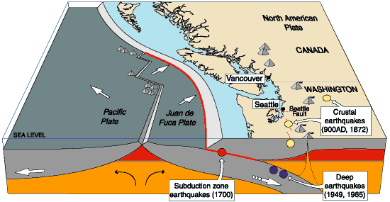
The EIS says “the local surface geology at the Prince Rupert site consists of bedrock (granitic rocks) overlain by glacial outwash and a thin soil cover.” and goes on to note that “Prince Rupert is located along the coastal region of Canada, which is seismically active.”

Potential Impacts

At Prince Rupert, depth to bedrock is expected to be relatively shallow, so rock ripping and some blasting could be necessary. The impacts of rock ripping and blasting are limited to the immediate area and would not result in any significant impacts to the underlying or nearby geology. Excavation activities, erosion of fossil beds exposed due to grading, and unauthorized collection can damage or destroy paleontological resources during construction.

(The report notes that The potential for finding paleontological resources in the areas that would be disturbed is unknown. But the area of the coast has been heavily metamorphisized and most fossils, so far, have been found further inland, largely along the Copper River near Terrace)

In terms of geologic hazards, the Prince Rupert terminals would be located along the coastal region of Canada, which is seismically active. In addition, the presence of steep slopes increases the risk of landslides and the port’s coastal location increases the risk of flooding…. The Prince Rupert rail terminals and port facilities would be designed to withstand potential seismic hazards and flooding…

Construction of the proposed terminals and port expansion in Prince Rupert would result in the disturbance of approximately 3,500 acres (1,400 hectares) of land for the construction of the rail terminal complex and approximately 1,200 acres (487 hectares) for the expansion of the port. Potential impacts to the soils resources of the area could result from vegetation clearance, landscape grading, and recontouring to ensure proper drainage, the installation of storm water drainage systems, construction of the required infrastructure, and other construction activities.
One of the primary concerns during construction activities is soil erosion and sedimentation.
Potential impacts to soils from erosion are expected to occur in areas where the slopes are greater than 20 per cent and where the erosion potential due to their nature is high. Based on available landscape and soils information, the soils found in the area are not highly erodible and the required infrastructure would be located in areas that are relatively flat. Therefore, the impact of the proposed terminal complex and port construction activities on soil erosion would be minor.


Groundwater
Environmental Setting

The Prince Rupert Terminals and port expansion would occur in British Columbia on Kaien Island, which receives about 102 inches of rainfall per year. The terminals would be located on an inlet that is part of the eastern Pacific Ocean on the Venn Passage near the much larger Inland Passage, which extends from Washington State to Alaska along the islands and mainland of British Columbia, Canada. Venn and Inland Passages are marine (salt water) waterbodies. The islands consist of bedrock (granitic rocks) overlain by glacial outwash and a thin soil cover.
Groundwater is shallow, poor quality, and unused. Drinking water is derived from lakes on the mainland. Water quality in the terminal complex area is seawater and inland brackish.

Potential Impacts

During construction of the facilities at Prince Rupert, the primary potential impacts to groundwater would be spills or leaks from construction equipment. Mitigation for these impacts includes having in place appropriate plans in place and appropriate cleanup materials available.
During operations of the facilities at Prince Rupert, the primary potential impacts to groundwater would again most likely be spills or leaks from operation equipment or associated with crude oil unloading of railcars. Although the initial impacts of potential releases or spills may be contained or limited to soil, potential impacts to groundwater may occur depending on the depth to groundwater, soil characteristics (e.g., porosity, permeability), spill volume and extent, and whether the spill reaches surface water bodies, some of which are interconnected to groundwater.

Surface Water
Environmental Setting

The upland character surrounding the potential Prince Rupert terminal area is dominated by bog forest uplands and the flowing surface water bodies are predominantly precipitation- and shallow groundwater-fed intermittent streams. Some open waterbodies are present in the southeast portion of Kaien Island. Tidal shore zones are of a rugged and rocky nature and receive wave energy generated by naturally occurring fetch and large wakes from marine traffic. Winter winds are strong and from the southeast to southwest, with surface currents predominantly northward from the Hecate Strait. Lighter summer winds have less influence on currents and allow freshwater runoff from land and deep water tidal effects to exert more control and provide variation in summer current patterns. Significant wind and tidal mixing tend to occur where waters are shallow and around islands and rocky points of land. The coastal landscape is predominantly fjords carved into the granitic Coast Mountains, created by the last of several glacial periods approximately 12,000 years ago. Shores tend to be rocky and steep with beaches restricted to sheltered areas adjacent to estuaries and the navigable straits and channels provide a wide variety of exposures and habitats.

Potential Impacts

Construction of the facilities at Prince Rupert would disturb approximately 4,700 acres. The primary potential impacts to surface waters include erosion and sedimentation and spills/leaks of hazardous materials. Mitigation for these impacts includes having in place appropriate SPCC plans in place and appropriate cleanup materials available.
During operations, the primary potential impacts to surface waters include storm water runoff, spills, or leaks from operation equipment or associated with crude oil unloading of railcars.
Provision of storm water management measures would mitigate the impacts of stormwater runoff.

Terrestrial Vegetation
Environmental Setting

The Prince Rupert terminals and port facilities would be located in the Coastal Gap Level III Ecoregion. The vegetation immediately adjacent to the Pacific Ocean includes stunted, opengrowing western red cedar, yellow cedar, and western hemlock with some stunted shore pine and Sitka spruce . There are also open areas present within the affected areas. It is unclear if biologically unique landscapes or vegetation communities of concern exist within the proposed Prince Rupert terminal complex boundary.

Potential Impacts

The proposed rail terminal complex and port facilities at Prince Rupert would require the clearing of up to 4,700 acres of natural vegetation, most of which is forested based on aerial photo interpretation. There does not appear to be any biologically unique landscapes or communities of conservation concern within the terminal complex boundary. Nearly all of these impacts would be permanent as natural habitats are converted for use as rail terminals and port facilities.

Wildlife
Environmental Setting

Many wildlife species use this coastal area for hunting, foraging, roosting, breeding, and nesting (Tourism Prince Rupert 2012). Wildlife characteristic of this ecoregion include grizzly bear (Ursus arctos horribilis), black bear (Ursus americanus), mountain goat (Oreamnos americanus), black-tailed deer (Odocoileus hemionus
columbianus), wolf (Canis lupus), moose (Alces alces), mink (Mustela sp.), bald eagle
(Haliaeetus leucocephalus), seabirds, shorebirds, waterfowl, and grouse (Tetraoninae)
The Prince Rupert terminal complex would be located in the Northern Pacific Rainforest(Region 5) bird conservation region, which is an ecologically distinct region in North America…

The coast of the Northern Pacific Rainforest is characterized by river deltas
and pockets of estuarine and freshwater wetlands set within steep, rocky shorelines. These wetlands provide critical nesting, wintering, and migration habitat for internationally significant populations of waterfowl and other wetland-dependent species. The area includes major stopover sites for migrating shorebirds, especially western sandpipers (Calidris mauri) and dunlins (Calidris alpina). Black oystercatchers (Haematopus bachmani), rock sandpipers (Calidris
ptilocnemis), black turnstones (Arenaria melanocephala), and surfbirds (Aphriza virgata) are common wintering species. Nearshore marine areas support many nesting and wintering sea ducks. Many seabirds breed on offshore islands, including important populations of ancient murrelet (Synthliboramphus antiquus), rhinoceros auklet (Cerorhinca monocerata), tufted puffin (Fratercula cirrhata), common murre (Uria aalge), western gull (Larus occidentalis), glaucouswinged gull (Larus glaucescens), and Leach’s storm-petrel (Oceanodroma leucorhoa). Pelagic
waters provide habitat for large numbers of shearwaters (Calonectris spp. and Puffinus spp.), storm-petrels (Hydrobatidae), and black-footed albatross (Phoebastria nigripes)

Potential Impacts

Direct impacts could occur due to vegetation removal or conversion, obstructions to movement patterns, or the removal of native habitats that may be used for foraging, nesting, roosting, or other wildlife uses (Barber et al. 2010). Indirect impacts to wildlife are difficult to quantify and are dependent on the sensitivity of the species, individual, type and timing of activity, physical parameters (e.g., cover, climate, and topography), and seasonal use patterns of the species (Berger 2004). Most of these impacts would be essentially permanent.

Fisheries
Environmental Setting

Prince Rupert is an important deepwater port and transportation hub of the northern coast of British Columbia. It is located on the northwest shore of Kaien Island, which is connected to the mainland by a short bridge. The town of Prince Rupert is just north of the mouth of the Skeena River, a major salmon-producing river. Key commercial fisheries include Pacific salmon, halibut, herring, and groundfish, which are processed from Prince Rupert.

Prince Rupert area supports a high density of streams and rivers that host an array of valuable recreational fisheries for salmon, steelhead (anadromous rainbow trout), rainbow trout, lake trout, cutthroat trout, char, Arctic grayling, and northern pike .

Potential Impacts

New impacts to commercial and recreational fisheries’ habitats from the construction and operation of the facilities in Prince Rupert could include marine intertidal zones as well as fish spawning zones (e.g., herring), if present. There would likely be short-term impacts to the benthic (bottom dwelling) community during construction of the berths and mooring facilities. Bottom-dwelling
fish (i.e., halibut, flounder, and rockfish) and marine invertebrates (i.e., clams, mussels, crabs, and other bivalves and crustaceans) could potentially be impacted during construction as well, but these affects are expected to be minor and temporary or short-term in duration.

Additional shipping traffic would increase underwater sound because large vessels, including tankers, put out relatively high noise levels. Fish and other aquatic organisms (including invertebrates and marine mammals) use sound as a means of communication and detection within the marine acoustic environment. Increased shipping traffic could mask natural sounds by increasing the ambient noise environment from Prince Rupert Harbor and along the marine route to the Gulf Coast area. Long-lasting sounds, such as those caused by continuous ship operation, can cause a general increase in background noise and there is a risk that such sounds, while not causing immediate injury, could mask biologically important sounds, cause hearing loss in affected organisms, and/or have an impact on stress levels and on the immune systems of aquatic species.

Exotic and invasive species are sometimes transferred in the ballast water of tanker ships.
Monitoring and controls would need to be implemented to treat ballast water discharged into Prince Rupert Harbor such that invasive or exotic species would not be released into the marine environment.

Threatened and Endangered Species

This section focuses on animal and plant species present in the Prince Rupert area that are Canada SARA protected. As a coastal area along the Pacific Migratory Bird Route, and an area that receives a lot of precipitation and is heavily forested, many wildlife species inhabit the area, as discussed in Section 5.1.3.6, Wildlife. According to the British Columbia (B.C.) Conservation Data Centre (2012), only one SARA threatened/endangered species is known to occur in Prince Rupert—the green sturgeon (Acipenser medirostris), a Pacific Ocean inhabitant. In addition, several SARA special concern species occur in Prince Rupert, including western toad (Anaxyrus boreas), coastal tailed frog (Ascaphus truei), North American racer (Coluber constrictor), grey whale (Eschrichtius robustus), and Stellar sea lion (Eumetopias jubatus)

Potential Impacts

The green sturgeon is typically found along nearshore marine waters, but is also commonly observed in bays and estuaries. The expansion of the proposed port facility could have minor adverse effects on the green sturgeon, but the sturgeon could readily avoid the port area.
Increased shipping traffic at Prince Rupert and as the vessels transit to the Gulf Coast area refineries may affect the feeding success of marine mammals (including threatened and endangered species) through disturbance, because the noise generated by tankers could reduce the effectiveness of echolocation used by marine mammals to forage for food. Whales use underwater vocalizations to communicate between individuals while hunting and while engaged in other behaviors. Increased underwater noise from additional shipping traffic could disrupt these vocalizations and alter the behavior of pods of whales. Moreover, additional boat and
tanker traffic could also increase the potential for collisions between marine mammals and shipping vessels. These effects would be additive in nature and could potentially add to existing disturbance effects and collision risks caused by the current level of shipping traffic, commercial and recreational fishing, and cruise ship passage.

Land Use, Recreation, and Visual Resources
Environmental Setting

Land use, recreation, and visual resources for the Prince Rupert area where the new terminals and expanded port facilities would be built differ sharply from the other terminal sites. Prince Rupert is located on an inlet of the Pacific Ocean in a heavily forested area of British Columbia.
Urban land use is generally limited to the communities in and around the city of Prince Rupert, with some small outlying communities and villages in the area. Given Prince Rupert’s role as a terminus of the Alaska Ferry System, many people see the port and surrounding areas in a recreational context. The area is largely undeveloped and would be sensitive to changes in the visual landscape.

Potential Impacts

If constructed on previously undeveloped land, the new facilities would primarily impact mixed forest… The construction and operational impacts on land use, recreation, and visual resources at the Lloydminster, Epping, and Stroud terminal complex sites and along the Cushing pipeline route would be the same as for the Rail/Pipeline Scenario.

Socioeconomics
Environmental Setting

Population/Housing

Construction and operations activities are not expected to have a significant effect on population and housing for this scenario. Because construction and operations job estimates have not yet been determined for this scenario, worker requirements for Prince Rupert, Lloydminster, and Epping are assumed to be minor..additional temporary housing could be needed in Prince Rupert… Prince Rupert only has about 740 hotel/motel rooms

Local Economic Activity

Tanker infrastructure and operations would be affected as ships transport crude oil from Prince Rupert through the Panama Canal to Texas ports near Houston.

Direct construction expenditures for facilities at Prince Rupert would be approximately $700 million, with approximately 1,400 annual construction jobs, based on the cost estimates of the proposed Enbridge Northern Gateway marine terminal in Kitimat

Despite the large population of First Nations people in the Prince Rupert area, Canada does not have a similar definition to minorities as the Keystone report applied under US law and so it notes “Impacts to minority and low-income populations during construction and would be similar to those described for the proposed [Keystone] Project and could possibly result in increased competition for medical or health services in underserved populations. Canada does not define HPSA and MUA/P, so it is unknown whether or not the minority populations in Prince Rupert or Lloydminster exist in a medically underserved area.

Tax Revenues and Property Values

It says construction of a new terminal Prince Rupert would generate provincial sales taxes, goods and services taxes, and hotel taxes. Construction of the tank and marine terminals at Prince Rupert…would involve large numbers of road trips by heavy trucks to transport construction materials and equipment to and from the sites. Construction in Prince Rupert could also potentially involve vessel deliveries of material. This traffic could cause congestion on major roadways, and would likely require temporary traffic management solutions such as police escorts for oversize vehicles.

Cultural Resources

Despite the rich heritage of First Nations in the Prince Rupert area, the Keystone alternative study reported;

No cultural resources studies have been conducted for the Prince Rupert area. Review of aerial photographs shows that a small portion of the area that could potentially be developed has already been disturbed by development, including port facilities, structures, and roads. This preliminary review shows that most of the area appears undeveloped and would have the potential for intact buried cultural resources.

The report notes that “Any ground disturbance, especially of previously undisturbed ground, could potentially directly impact cultural resources.”

It goes on to note that the potential to

include intact buried cultural resources would require evaluation through research and cultural resources surveys. If cultural resources were identified, follow-up studies could be required. In general terms, the archaeological potential of heavily disturbed areas, such as might be found in active rail yards or within developed transportation corridors, is normally lower than in undisturbed areas.

Archaeological potential is also contingent upon factors such as access to water, soil type, and topography, and would have to be evaluated for each area to be disturbed. Aboveground facilities have the potential to indirectly impact cultural resources from which they may be visible or audible. The potential for increased rail traffic to contribute to indirect impacts would require consideration.

Air and Noise

The report also summarizes the possible green house gas emissions for the rail and tanker project as whole from Prince Rupert to the Gulf Coast refineres and notes that overall

On an aggregate basis, criteria pollutant emissions, direct and indirect GHG emissions, and noise levels during the operation phase for this scenario would be significantly higher than that of the proposed [Keystone XL] Project mainly due to the increased regular operation of railcars, tankers, and new rail and marine terminals.

Air Quality

The rail cars and tankers transporting the crudes would consume large amounts of diesel fuel and fuel oil each day….The criteria pollutant emissions would
vary by transportation segment, particularly during marine-based transit. Oil tankers traveling from the Prince Rupert marine terminal through the Panama Canal to Houston/Port Arthur pass through several different operational zones, including reduced speed zones leading into and out of the ports, North American Emission Control Areas where the use of low-sulfur marine fuel is mandated, and offshore areas where the tankers travel at cruise speeds.

During the return trip, tankers are filled with seawater (ballast) to achieve buoyancy necessary for proper operation, which affects the transit speeds of the vessel. Furthermore, the tankers spend several days loading or unloading cargo at each marine terminal with auxiliary engines running (an activity called hoteling). The tanker emissions accounted for return trips (i.e., both loaded cargo going south and unloaded cargo going north).

In aggregate, the total operational emissions (tons) estimated over the life of the project (50 years) are several times greater than those associated with the combined construction and operation of the proposed Keyston XL Project

Greenhouse Gases

Direct emissions of GHGs would occur during the construction and operation of the Rail/Tanker Scenario. GHGs would be emitted during the construction phase from several sources or activities, such as clearing and open burning of vegetation during site preparation, operation of on-road vehicles transporting construction materials, and operation of construction equipment for the new pipeline, rail segments, multiple rail and marine terminals, and fuel storage tanks.

Due to limited activity data, GHG emissions from construction of the Rail/Tanker Scenario were not quantified; however, these emissions would occur over a short-term and temporary period, so construction GHG impacts are expected to be comparable to the proposed [Keystone XL] Project.
During operation of the railcars and tankers that comprise this scenario, GHGs would be emitted directly from the combustion of diesel fuel in railcars traveling over 4,800 miles (7,725 km) and fuel oil in marine tankers traveling over 13,600 miles (21,887 km) round-trip.

The Rail/Tanker Scenario would also result in indirect emissions of GHGs due to the operation of 16 new rail terminals, an expanded port, and potential pumping stations. The new rail terminal in Prince Rupert would be projected to require 5 MW of electric power to operate, possibly bring indirect GHG emissions

Noise

Noise would be generated during the construction and operation of the Rail/Tanker Scenario. Noise would be generated during the construction phase from the use of heavy construction equipment and vehicles for the new pipeline, rail segments, and multiple rail and marine terminals, and fuel storage tanks. Due to limited activity/design data, noise levels from the construction of this scenario were not quantified; however, this noise would occur over a short term and temporary period, so construction noise impacts are expected to be comparable to those
of the proposed Project. During operation of the railcars and tanker ships that comprise this scenario, noise would be generated from the locomotives, movement of freight cars and wheels making contact with the rails as the train passes, train horns, warning bells (crossing signals) at street crossings, and tanker engines during hoteling and maneuverings at the new rail and marine terminals in Prince Rupert.

(Noise from ocean going vessels which is a concern for coastal First Nations and environmental groups is covered later on impact on wildlife)


Climate Change Effects on the Scenario
Environmental Setting

The Keystone study looks at the affects of climate change, but concentrates largely on the Gulf Coast beause the most of the Rail/Tanker Scenario was outside of the boundaries of the study, but it does note that the sea levels are projected to rise due to glacial melting and thermal expansion of the water. The rate, total increase, and likelihood of the rise is in part dependent on how rapid the ice sheets warm and is a source of ongoing scientific uncertainty.

The United States Global Change Research Program (USGCRP) estimates that sea level rise could be between 3 to 4 feet by the end of the century.

Increasing sea level projected due to climate changes as described above shifts the impact of mean high tide, storm surge, and saltwater intrusion to occur further inland and this would negatively affect reliable operation of the port infrastrucure for tanker traffic. Mitigation of these climate effects could be addressed by making engineering and operational changes at the port.

Potential Risk and Safety
Environmental Setting

The Rail/Tanker Option would combine the risk inherent in both pipeline and oil tanker
transport. However, the risks and consequences for using oil tankers to transport the hazardous materials are potentially greater than the proposed Project. Overall, crude oil transportation via oil tankers has historically had a higher safety incident rate than pipelines for fire/explosion, injuries, and deaths.

Spills have been reported while the vessel is loading, unloading, bunkering, or engaged in other operations

The main causes of oil tanker spills are the following:
• Collisions: impact of the vessel with objects at sea, including other vessels (allision);
• Equipment failure: vessel system component fault or malfunction that originated the release of crude oil;
• Fires and explosions: combustion of the flammable cargo transported onboard;
• Groundings: running ashore of the vessel; and
• Hull failures: loss of mechanical integrity of the external shell of the vessel.

From 1970 to 2011, historical data shows that collisions and groundings were the maincauses of oil tanker spills worldwide.

Potential Impacts

Loading and unloading of the railcars at tank farms near seaports could allow spills to migrate and impact seawaters and shorelines.

However, the loading and unloading are generally carried out under supervision and would be addressed promptly by the operators, limiting the potential migration and impacts of the spill to the immediate area.

Once the tanker is loaded and at sea, the propagation and impacts of a spill could become significant. Oil tankers may carry up to 2,000,000 bbl of oil

A release of oil at sea would be influenced by wind, waves, and current. Depending on the volume of the release, the spreading of oil on the surface could impact many square miles of ocean and oil birds, fish, whales, and other mammals and could eventually impact shorelines. Oil would also mix with particulates in sea water and degrade. As this occurs some oil will begin to sink and either be retained in the water column (pelagic) or settle to the ocean floor (sessile).

Pelagic oil could be consumed by fish or oil fauna passing though the submerged oil. Sessile oil could mix with bottom sediment and potentially consumed by bottom feeding fauna. Spills in ports-of-call could affect receptors similar to an open ocean release but also could temporarily affect vessel traffic and close ports for cleanup activities.

The identification of key receptors along the rail route alternative was not available for this evaluation. Therefore a comparison to the proposed project was not completed.

Surface Water

The Lloydminster to Prince Rupert portion of this route would begin in the western plains at the Saskatchewan/British Columbia border and travel west through an area of high-relief mountains with large valleys, referred to as the Cordillera region. From a water resource perspective, the plains region of Canada is characterized by relatively large rivers with low gradients. The plains rivers drain the Rocky Mountains to the Arctic Ocean. The Cordillera region is largely composed of northwest-southwest trending mountain ranges that intercept large volumes of Pacific
moisture traveling from the west towards the east. River systems in this region are supplied by a combination of seasonal rainfall, permanent snowfields, and glaciers.

The following are larger rivers crossed by the existing rail lines between Lloydminster and Prince Rupert:

• North Saskatchewan River, Alberta
• Pembina River, Alberta
• McLeod River, Alberta
• Fraser River, British Columbia
• Nechako River, British Columbia
• Skeena River, British Columbia

Wetlands

Spills within wetlands would most likely be localized, unless they were to occur in open, flowing water conditions such as a river or in the ocean. A crude oil spill in a wetland could affect vegetation, soils, and hydrology. The magnitude of impact would depend on numerous factors including but not limited to the volume of spill, location of spill, wetland type (i.e., tidal versus wet meadow wetland), time of year, and spill response effectiveness. The construction of additional passing lanes to accommodate increased train traffic resulting from this scenario could
result in permanent impacts to wetlands if passing lanes were constructed where wetlands occur.
However, as there is some leeway regarding the exact location of the passing lanes, it is expected that wetlands would be avoided by design.

Fisheries

The Rail/Tanker Scenario railroad route would cross numerous major streams and rivers in Canada, many of which support anadromous fish species such as salmon.

Anadromous species are those that spawn and rear in freshwater but migrate to the ocean at a certain size and age. Pacific salmon are large anadromous fish that support valuable commercial and recreational fisheries. Commercial fisheries for salmon occur in marine water and most recreational fishing for salmon occurs in freshwater. Salmon eggs are vulnerable to the effects of fine sediment deposition because female salmon deposit their eggs in stream bed gravels.

Despite this vulnerability, the overland railway route is not expected to present any new impacts to salmon unless there is a spill into its habitat, although the risk of spills does increase under this scenario due to the increase in the number of trains that would use the route.

Potential new impacts under the Rail/Tanker Scenario on commercially or recreationally significant fisheries along the route would be minor because the railroads that would be used are already built and in operation. However, the risk of an oil spill or release of oil or other materials still exists. The tanker portion of this route scenario is also subject to oil spill risk.

Threatened and Endangered Species

The rail route would cross over the Rocky Mountain region of western Alberta, which is inhabited by species such as the woodland caribou (Rangifer tarandus) (a SARA threatened species) and grizzly bear (a SARA special concern species). This region of British Columbia is home to a number of SARA threatened/endangered species, including the peregrine falcon (Falco peregrinus anatum) (SARA threatened), salish sucker (Catostomus sp.) (SARA endangered), white sturgeon (Acipenser transmontanus) (SARA endangered), caribou (southern mountain population) (SARA threatened), northern goshawk (Accipiter gentilis laingi) (SARA threatened), and Haller’s apple moss (Bartramia halleriana) (SARA threatened).

A number of additional SARA special concern species inhabit the regions of Canada that would be traversed by the Rail/Tanker Scenario, including but not limited to those special concern species expected to occur in the Prince Rupert region, and discussed above (B.C. Conservation Centre 2012).

Northwest Coast Energy News Special report links

What the Keystone Report says about Kitimat and Northern Gateway
What the Keystone Report says about the Kinder Morgan pipeline to Vancouver.
What the Keystone Report says about CN rail carrying crude and bitumen to Prince Rupert.
The State Department Environmental Impact Study of the railway to Prince Rupert scenario.

State Department news release

State Department Index to Supplemental Environmental Impact Study on the Keystone XL pipeline


Douglas Channel in Black and White

[photoshelter-gallery g_id=”G000034M5Z2_lI4Q” g_name=”Douglas-Channel-in-black-and-white” f_show_caption=”t” img_title=”iptch” pho_credit=”iptc” f_link=”f” f_send_to_friend_btn=”t” f_fullscreen=”t” f_topbar=”t” f_bbar=”t” f_htmllinks=”t” f_mtrx=”t” fsvis=”f” width=”615″ height=”461″ f_constrain=”t” bgcolor=”#AAAAAA” btype=”new” bcolor=”#CCCCCC” crop=”f” trans=”xfade” tbs=”10000″ f_ap=”t” bgtrans=”f” linkdest=”c” twoup=”f” f_bbarbig=”” f_enable_embed_btn=”f” f_show_watermark=”f” f_show_slidenum=”f” f_smooth=”f” f_up=”f” target=”_self” wmds=”llQ6QNgpeC.p1Ucz7U.Y5p9TTphsaUCWglrsuG3u3BJwmfV6PzC2SqyK_HnEz4rFhVjU4A–” ]

Photogallery. For full screen mode with captions, click on the box to the right of the bottom menu bar.

The long, magnificent fjord known as Douglas Channel was carved by a glacier thousands of years ago, some of the islands are rock uplifted by tectonic forces, others piled up by retreating glaciers.

So far, since I returned to Kitimat, I have had few chances to “go down the Channel,”  as the people of Kitimat say.

Of course, when I do go,  I always have a camera with me, even in the roughest weather–and the Channel can be rough most of the year.

It is in these waters that the energy industry, both the Enbridge Northern Gateway and the Liquefied Natural Gas projects want to use supertankers to send their products to markets in Asia. Many of the photographers who come to Douglas Channel in high summer choose to capture the brilliant colours of ocean, forest and mountain, as I have on several assignments.

For this gallery, I have chosen to use black and white to show the stark beauty of the mountains, the often menacing seas and the clouds, ever changing, as the westerly winds from the Pacific drive those clouds against the mountains.

Images from this gallery are available for purchase for personal, editorial and commercial  use on Photoshelter. Simply click on the image above.

DFO report to JRP says Northern Gateway pipeline will cross “high-risk” streams but releases only two examples on Kitimat watershed

A Department of Fisheries and Oceans report filed Wednesday, June 6, 2012, with Joint Review Panel says the department has identified streams on the Northern Gateway Pipeline route that Enbridge identified as “low risk” but which DFO considers “high risk.” However, in the filing, DFO says it can’t release a comprehensive list of the high risk streams, preferring instead to give two examples on the Kitimat River watershed.

The DFO report comes at a time when the Conservative government is about to pass Bill C-38, which will severely cut back DFO’s monitoring of the majority of streams. It appears that the anonymous DFO officials who wrote the report acknowledge that they may soon have much less monitoring power because the report says:

Under the current regulatory regime, DFO will ensure that prior to any regulatory approvals, the appropriate mitigation measures to protect fish and fish habitat will be based on the final risk assessment rating that will be determined by DFO.

Note the phrase “under the current regulatory regime.”

The report also identifies possible threats to humpback whales from tanker traffic.

In the report, DFO notes that Northern Gateway’s “risk management framework” is based on DFO’s own Habitat Risk Management Framework, and DFO, notes “the approach appears to be suitable for most pipeline crossings.”

However, DFO further remarks that it has identified

some examples where crossings of important anadromous fish habitat have received a lower risk rating using Northern Gateway’s framework than DFO would have assigned. In addition, DFO has identified some instances where the proposed crossing method could be reconsidered to better reflect the risk rating.

In bureaucratic language, the Department says “DFO reviews impacts to fish and fish habitat and proposed mitigation measures through the lens of its legislative and policy framework” again a strong hint that the legislative and policy framework is about to change.

It goes on to say:

The appropriate approach to managing risks to fish and fish habitat is based on the risk categorization. For example, where high risks are anticipated DFO may prefer that the Proponent use a method that avoids or reduces the risk such as directional drilling beneath a watercourse to install the pipeline. If low risks are anticipated other methods such as open-cut trenching across the watercourse may be appropriate.

While DFO is “generally satisfied” with Northern Gateway’s proposed approach, it says “DFO has identified some crossings where we may categorize the risk higher than Northern Gateway’s assessment.”

DFO then gives Enbridge the benefit of the doubt because:

Northern Gateway continues to refine the pipeline route and we anticipate that assessment of risk will be an iterative process and, if the project is approved and moves to the regulatory permitting phase, DFO will continue to work with Northern Gateway to determine the appropriate method and mitigation for each watercourse crossing. In DFO’s view, Northern Gateway’s approach is flexible enough to be updated if new information becomes available.

DFO then says it

has not conducted a complete review of all proposed crossings, we are unable to submit a comprehensive list as requested; however, this work will continue and, should the project be approved, our review will continue into the regulatory permitting phase. While there may be differences in opinion regarding the risk categorization for some proposed watercourse crossings, DFO will continue to work with Northern Gateway to determine the appropriate risk rating and level of mitigation required.

Here is where DFO points to current, not future policy, when it says:

DFO is of the view that the risk posed by the project to fish and fish habitat can be managed through appropriate mitigation and compensation measures. Under the current regulatory regime, DFO will ensure that prior to any regulatory approvals, the appropriate mitigation measures to protect fish and fish habitat will be based on the final risk assessment rating that will be determined by DFO.

The report then gives two examples of high risk streams both in the Kitimat River watershed


Example 1) Tributary to the Kitimat River, KP 1158.4 (Rev R), Site 1269

Northern Gateway Rating: RMF: Low Risk

DFO Rating: RMF: Medium to High Risk

Rationale: This is a coastal coho salmon spawning stream that is quite short in length. It has several historic culverts in poor repair which are already impacting the reported run of approximately 100 spawning salmon. Works can be completed in the dry as this stream dries up during the summer. DFO is of the opinion that the risk rating is higher than that proposed by Northern Gateway due to the sensitivity of incubating eggs and juveniles of coho salmon to sediment and the importance of riparian vegetation for this type of habitat.


Example 2) Tributary to the Kitimat River, KP 1111.795 (Rev R), Site 1207

Northern Gateway Rating: RMF: Medium Low Risk

DFO Rating: RMF: Medium to High Risk

Rationale: In DFO’s view the risk rating for this watercourse is higher than that proposed by Northern Gateway because this stream is high value off-river rearing habitat for juvenile salmon such as coho salmon. This type of fish habitat is vulnerable to effects of sedimentation and loss of riparian vegetation.


Humpback Whales

The Joint Review Panel also asked DFO for a comment on the status of the humpback whale, especially in the shipping area in the Confined Channel Assessment Area Between Wright Sound and Caamaño Sound.

DFO responds

Four areas of critical habitat were proposed for humpback whales in coastal British Columbia in the Draft Recovery Strategy released in 2010, including the Confined Channel Assessment Area from Wright Sound to Caamaño Sound. However, humpback whales have recently been re-assessed by the Committee on the Status of Endangered Wildlife in Canada (COSEWIC) and were redesignated ‘Special Concern’ but remain ‘Threatened’ under the Species at Risk Act (SARA). A draft recovery strategy for the humpback whale has been prepared.
It is unclear if humpback whales are still protected as a Schedule 1 status species under the SARA and whether a recovery strategy has been finalized.

Fisheries and Oceans Canada Response to the JRPs IR Request  (pdf)

Editorial: It’s time for the District of Kitimat to play hardball on Gateway

EDITORIAL

Who speaks for Kitimat?

Someone has to speak for Kitimat on the Northern Gateway project.

The District of Kitimat Council no longer has a choice. It’s time to play hardball with Ottawa and Enbridge on the Northern Gateway Pipeline.

You can’t negotiate from a position of weakness.

The game of pipelines changed forever in recent weeks, when the Conservative government introduced Bill C-38, the Budget Implementation Act.

Bill C-38, which passed Second Reading on May 14, 2012 is an affront to basic democratic principles, a 425 page omnibus monster that will not permit the kind of careful consideration of major changes in Canadian society that what was once normal in a free and democratic society. The omnibus bill not only concerns the federal budget but also repeals the environmental assessment process and guts fisheries protection for the smaller spawning streams where salmon are born. By giving the federal cabinet the power to overrule the National Energy Board, the decision on the pipeline rests with just one man, Prime Minister Stephen Harper, who has made no secret that he intends to push the project through no matter how fierce the opposition to the project.

This week has seen devastating cutbacks along the west coast, to environmental monitoring and pollution control, to Coast Guard protection.  It is now clear that protection of the environment  along the BC coast and the lives of the mariners who sail those waters are of little importance to Ottawa, and of no importance to the war room types counting votes in Alberta and suburban ridings outside Toronto and Vancouver.

The District of Kitimat Council has voted to wait to make a decision until after the report of the Joint Review Panel, when “all information” is available.

The news this week that the Joint Review Panel decided to bypass Kitimat, that the town that is to be the terminal of the proposed pipeline is irrelevant to the process, shows more than any other move what the JRP thinks of Kitimat. Not much.

The Joint Review Panel has lost all credibility. Even if the JRP does produce a fair and honest report with valid recommendations for conditions and restrictions, it is highly unlikely that those recommendations will be fully implemented, because the final decision will be made in the Prime Minster’s Office and that decision will be build, baby, build.

Media reports in recent months have shown that Enbridge has easy access to the senior levels of the Conservative government and Enbridge lobbying preceded the changes to the Fisheries Act in Bill C-38.  Enbridge  walks the halls of power in Ottawa. Kitimat, on the other hand, counts for little, as the JRP schedule clearly shows.

So, for example, even if the Joint Review Panel recommends strict conditions on the pipeline to insure the safety of Kitimat’s water supply, and if Enbridge doesn’t like those conditions, there is no guarantee that Harper and the cabinet will implement those recommendations. That would leave the District of Kitimat holding the water barrel for several years.

(One of the many reasons, it seems, that the JRP wants to have all the northwest hearings is in Prince Rupert is so the high-priced energy lawyers from Calgary can have comfortable accommodation. So, if any protests from the District and the Haisla Nation are successful and there actually are final hearings in Kitimat,  perhaps the District could arrange for the lawyers to camp in Radley Park, so they can actually grasp the realities of living in Kitimat by the Kitimat River.)

The District of Kitimat Council has a duty to make sure that this region is protected.

So what does this mean?

“Armed neutrality”

It is now too late for the District Council to take a position for or against the pipeline. It no longer matters whether Mayor and Councillors support the pipeline, are sitting on the fence or oppose the pipeline. Bill C-38 has made the decision for the Council.

Council must assume that Stephen Harper will impose the pipeline on Kitimat and will impose conditions that could be determinable to the District in favour of Alberta and Enbridge.

From now on Council must unify and work to protect the District from Stephen Harper. The Council must make sure that the District is an aggressive force at any negotiating table or court battle.

That means Council should retain its position of neutrality, leaving opposition to the pipeline to others like Douglas Channel Watch. Given the growing witch hunt against the environmental movement, an official position of neutrality is negotiating from a position of strength and protects the District from any accusation that “radicals” are distorting the District’s position.

In international affairs, countries like Switzerland and Sweden are neutral, robustly neutral. Both Switzerland and Sweden practice what is called “armed neutrality.”

“Armed neutrality” means that Kitimat Council can no longer continue its current wishy-washy neutrality, arguing over the nuances of words in letters to the Joint Review Panel and Enbridge. To protect Kitimat, Council must adopt its own policy of “armed neutrality,” an aggressive stance that represents the entire community, both opponents and supporters of the pipeline.

So what now?

Professional advice

The announcement this week that Shell is planning to build a liquified natural gas facility in Kitimat, in combination with the KMLNG and BC LNG projects plus Enbridge, means it is vital for the District to have independent, professional advice on energy issues.

The District must immediately start paying much closer attention to the all the relevant documents that are filed with the Joint Review Panel. The District Council and staff must have their own independent advisers rather than juggling the views of Douglas Channel Watch and Enbridge and hoping for the best. That means hiring more professionals to supplement current staff that will understand the technicalities of both the Enbridge pipeline and the LNG projects; staff who can advise the senior administration and Council about how to proceed where the issues of the pipeline construction, terminal construction and management of the terminal come under municipal jurisdiction or could adversely affect the municipality.

That takes money, even though money is tight, Council must budget for that staff. When it comes to negotiating factors within the responsibility of the municipality, Kitimat must be at the table at full strength.

All the way to the Supreme Court

It is now certain that after Stephen Harper orders the pipeline to go ahead, disputes over the Northern Gateway Pipeline will end up in the courts. Lawyers are already talking about the constitutional necessity to consult First Nations, that pushing the pipeline across aboriginal traditional territory will violate Rights and Title.

First Nations across British Columbia are already represented by some of the best lawyers in Canada.

Vancouver is already looking at what powers a municipality has to make sure that city is fully protected in case of a catastrophic tanker accident from the Kinder Morgan pipeline and project.

Yes, the District is wary because of the long and bitter fight over power allocation, but that is in the past. Again Bill C-38 gives the District no choice but to prepare for new legal battles, probably all the way to the Supreme Court of Canada.

The District of Kitimat must immediately budget for, seek out, retain and instruct a law firm that  can advise the District on its rights and responsibilities now and in the future once the Harper government imposes the pipeline on Kitimat. As we have seen from the Joint Review and other National Energy Board hearings, the energy industry hires the best lawyers money can buy.

If Kitimat has to face those lawyers, the District can’t act like a Junior B team facing the NHL All-Stars. That law firm should be able to advise Kitimat on the constitutional issues involved and what powers a municipality has to protect the community from unwanted and unwarranted aspects of pipeline and tanker development. That law firm must also be able to participate in hardball business negotiations.

Seeking Alliances

The District must build better bridges with the Haisla Nation and find where there is common ground in the Kitimat region as Stephen Harper imposes the pipeline on the northwest. They may be arguments before the courts or with Enbridge where both the Haisla and the District of Kitimat are allies in a fight.

Stephen Harper and his government are prepared to impose the pipeline, terminals and tanker traffic on northwestern British Columbia, again no matter what local municipalities and regions say. All the environmental and Coast Guard safeguards that might have brought acceptance of the Enbridge project are being cut to the bone. That means Kitimat must also forge alliances with those municipalities and regions, again to make sure that local rights and responsibilities are fully protected once the government decides to impose the pipeline on the northwest.

It is highly likely that the constitutional consultation and Rights and Title cases on the pipeline will end up at the Supreme Court of Canada. If there are other cases, perhaps raised by Vancouver or other Lower Mainland or northern communities or even the Province of British Columbia, it may be that the Supreme Court, as it has with some cases in the past, could consolidate all the pipeline cases into one. That means Kitimat will need to be a participant in any case on the pipeline before the Supreme Court.

Unless District of Kitimat Council starts playing hardball, Stephen Harper will drive a bulldozer down bank of the Kitimat River to Douglas Channel, ignoring the council standing and watching from the hill looking over the pipeline trench.