Where was the big aftershock? East of Haida Gwaii, USGS, west of Haida Gwaii, Natural Resources Canada

USGS map of Oct 31 aftershock
A map from the USGS shows that the latest 5.1 aftershock from the Oct. 27 earthquake occurred east of Haida Gwaii, in Hecate Straight. (USGS)

The latest aftershock from the 7.7 magnitude earthquake off Haida Gwaii occurred east of the islands, according to preliminary data released by the US Geological Survey. Canadian data, however, shows the quake west of Haida Gwaii.

The USGS marked the aftershock at 52.500°N 131.100°W at a depth of one kilometre or .6 mile. No tsunami warning was issued.

Natural Resouces Canada data puts the quake at 52.4 North 132.4 West, adding the earthquake “was felt at Queen Charlotte City and Skidegate. There are no reports of damage, and none would be expected.”

The NRC map shows the aftershock on the Queen Charlotte fault line.  However, if the USGS map is correct, an aftershock on the east side of Haida Gwaii could raise questions of the potential hazard for Douglas Channel.

Both services said the aftershock occurred at 3:15 am November 1, using Universal Time. An automatic bulletin from the Canadian earthquake centre recorded the quake as 5.0 20:15 PDT. Oct, 31, 97 km SSW of Queen Charlotte City.

No tsunami warning was issued.

According to the USGS the aftershock was

181km (112mi) SSE of Masset, Canada
208km (129mi) SSW of Prince Rupert, Canada
278km (173mi) SW of Terrace, Canada
493km (306mi) NW of Campbell River, Canada
679km (422mi) SSE of Juneau, Alaska

Natural Resources Canada map showing its call on the location of the Oct. 31 aftershock.

USGS link to add aftershock location to Google Maps


USGS earthquake report

Natural Resources Canada earthquake report

Northwest Coast Energy News will update this story if newer data is available Thursday morning. Although no tsunami warning was issued, tonight’s event is another example of the confusion that can result from automatically generated earthquake data. If the event east of Haida Gwaii is confirmed, it means that the level of tsunami hazard for Douglas Channel will have to be reconsidered.

After the earthquake: Kitimat must immediately upgrade its emergency communications

As a 7.7 magnitude earthquake hit off Haida Gwaii shortly after eight o’clock on Saturday, I was at the Haisla Recreation Centre as the Haisla Nation marked the return of the G’ps Golox totem pole. Like a boat being lifted by gentle waves, the Rec Centre began to quietly roll up and down, then the rolling seemed to accelerate just a bit. I realized that it was an earthquake. As I told CBC’s Ian Hanomansing  later in the evening, I have been in a number of earthquakes, and for me at least, this quake, at least at Kitamaat Village, the rec centre was not shaking as badly as in some of the others I have felt.

The subsequent events of the evening show that the emergency communication system in Kitimat needs immediate improvement.

Cell service

Cell phone service at the village is poor and after the rolling stopped neither myself nor my Kitimat Daily colleague Walter McFarlane was able to get “bars.”

Now as a former network producer for both CBC and CTV I have handled a large number of earthquake stories from around the world over the past quarter century (sitting at a desk, I should add). With that experience, I was hoping to get a cell hit at the village so I could bring up Twitter. I already subscribe to the US Geological Survey and Canadian earthquake alert feeds. The US and Canadian computers automatically report earthquakes within seconds of detection and send out a Twitter bulletin as the same time as those computers are alerting their human masters. If I had been able to get cell service I would have known within minutes that the Haida Gwaii earthquake was a major event. (I did follow the alerts from my computer once I got back to Kitimat itself).

Recommendation One. Cell service in Kitimat, Kitamaat Village, the harbour area must be upgraded as soon as possible. Telus has applied to council to erect a new cell tower here. Given the events of the past 24 hours, District Council should make sure that all parts of the District of Kitimat and the Haisla Nation have proper cell coverage no matter what service one subscribes to, not just for the convenience of subscribers but for emergency situations.

Automatic alerts

With experience one knows that in a situation such as Saturday night, the official websites such as the US Geological Survey and the Pacific Tsunami Warning Center as well as  Natural Resources Canada are often overwhelmed. That is why the media use RSS feeds, Twitter feeds and e-mail alerts. It is also important to realize that these emergency organizations have their own language and procedures. It appears that a lot of the confusion on Saturday came from misinterpretation of the various Canadian and US warning systems.

Recommendation Two. If Kitimat emergency services are not familiar with how the US based earthquake and tsunami centres work, they should be trained in those systems, simply because the Americans are well ahead of Canada in these areas because the alerts go out by computer automatically and are constantly updated and as Saturday night showed, are often quicker and farther ahead than the Canadian systems.

Once I was back in Kitimat, it was clear that communications were breaking down, and this was at a time the tsunami warning was still active. There were numerous messages on Twitter and Facebook, from residents of Kitimat either trying to find out what was going on or retweeting/reposting rumours including one that the Kildala neighbourhood was being evacuated. I am told that residents were calling the RCMP to ask what was going on. This was another breakdown since North District HQ in Prince George handles all police services in this region and were likely busy with quake calls on Haida Gwaii, so that information calls in Kitimat that should have been handled by an emergency services public communications person were being handled the Mounties.

There were reports that one man was going door to door in Kildala telling people to evacuate. Whether this person was well intentioned but misinformed or a imposter intent on mischief doesn’t matter, there was an information vacuum.

It was clear from Twitter that other districts and municipalities were using that service to spread official information. (I don’t follow other areas on Facebook so it is unclear if information was being posted on Facebook. There was certainly no official presence from Kitimat on Facebook Saturday night.) It appears from reports in the Kitimat Daily and tweets about the Northern Sentinel that Kitimat emergency services was sending information out by fax. While faxing information was an advance in the 1980s, faxes are obsolete in 2012. Many major newsrooms no longer use fax machines after being inundated by junk faxes and after they laid off all the editorial assistants who would have cleared those fax machines (even by the late 90s most faxes were dumped in the garbage unless the EA had been told to look for a specific fax). Also though it is now more than two years since I returned to Kitimat and I regularly freelance for Global, CBC and Canadian Press, I had no contact from anyone in emergency services (also I don’t have a fax machine).

Recommendation Three: The District of Kitimat must immediately bring its emergency communications into the 21st century, with Twitter accounts, a Facebook page and an emergency e-mail or text message plan for media and other officials who can get the messages. ( A number of jurisdictions already use text messages for emergency alerts at various graduated levels, official, media, public). When the main means of communication today is social media, an emergency organization can no longer follow outdated procedures, an organization must be on social media immediately it becomes clear that there is an emergency (as we are seeing with all the official tweets with the Hurricane Sandy crisis on the east coast)

CFTK

In an emergency situation, local radio and television are vital to communications and letting people know what is going on.

CFTK did a much better job on March 27. 1964 after Kitimat felt the magnitude 9.2 Good Friday Anchorage earthquake than it did on the weekend with the Haida Gwaii earthquake.

The inadequate coverage of the quake was certainly not the fault the of the current CFTK news staff who were working hard (probably on their own time and unpaid) keeping Twitter updated with what they knew. The fault lies with corporate management across the media which these days doesn’t want to spend the money and resources and training to fulfill the public service portion of their broadcast licence mandate.

(There was a similar breakdown in the May 2000, Walkerton, Ontario e-coli crisis where the local medical officer of health was initially unable to alert the public because local radio wasn’t staffed on the weekends–the local stations were taking satellite feeds from their corporate headquarters)

In 1964, long before satellites, when the microwave towers that joined CFTK to the Canadian networks were still being built, the staff of CFTK, then, of course under local management, went to a live special within an hour of the Anchorage quake being felt far off from Alaska in Kitimat. The CFTK anchors were keeping its audience updated with “rip and read” wire copy, a camera on an atlas for a map and phone interviews.

In contrast, on this Saturday night, CFTK was taking the CBC BC network feed which was a hockey rerun (hardly a show that attracts  major audience numbers and certainly not a vital broadcast) until the CBC management in Vancouver decided to go to full network news special.

Since CFTK is the station that broadcasts not only to Kitimat, but to Haida Gwaii as well, CFTK should have been ahead of Vancouver on this story, called in its staff and mounted their own live special, joining the CBC feed when it began but, as on an election night, breaking away for local news when justified. CFTK has a responsibility under its licence from the CRTC to provide that service to the northwestern region, not just sending what ad revenue it generates back to Astral.

Rio Tinto Alcan

Another question that must be asked in this situation is where was Rio Tinto Alcan on Saturday night? In all areas that were under a tsunami warning the first scrutiny and clue if there was to be a problem is that region would be found by observing what has happening between the low tide line and the maximum hide tide line. In Prince Rupert, from the Twitter feeds I saw, public officials were monitoring the waterfront and the tide lines and updating the public. RTA has all the advantages of the private port of Kitimat. It appears that monitoring the water level at the tide lines at the port of Kitimat was the responsibility of Plant Protection. Was RTA communicating what was happening with emergency services? Since RTA runs the private port, unlike in other jurisdictions, RTA had a responsibility to the people of Kitimat to report promptly to the public the conditions on the waterfront. Corporate public relations cannot just be sending out news releases with “good news.” That means that RTA public relations should have used its corporate Twitter account which usually sends out a news release every few weeks, to keep Kitimat updated on a minute-by-minute basis. If RTA communications staff in Kitimat do not have access to the RTA corporate Twitter account, they should establish their own local Twitter feed.

Both in 1964 and in 2012, the tsunami that came up Douglas Channel was minimal. But we know that this region does have a record of major quakes and that Douglas Channel has also experienced major landslides that can, in some circumstances, trigger a tsunami without an earthquake. The next few years will be seeing more industrial development along Douglas Channel which can also bring other hazards to the Kitimat region. While there are always communications breakdowns in situations like happened on Saturday, it is clear that the Kitimat emergency communications system needs a major upgrade to make sure the public is informed quickly and accurately of what is going on.


Geological Survey of Canada identifies tsunami hazard, possible fault line on Douglas Channel

Fault zone map Douglas Chanel
A map from the Geological Survey of Canada showing the line of a possible seismic fault on Douglas Channel (Geological Survey of Canada)


Updates with statement from Natural Resources Canada, new filings by Enbridge Northern Gateway and the Attorney General of Canada (in box below)

The Geological Survey of Canada has identified a tsunami hazard and a possible seismic fault in Douglas Channel near Kitimat. A scientific paper by the Geological Survey and the Department of Fisheries and Oceans says there were once two giant landslides on Douglas Channel that triggered major tsunamis and that the landslides were possibly caused by an earthquake on the fault line.

Kitimat is the proposed site of the Enbridge Northern Gateway project and at least three liquified natural gas projects.

If the projects go ahead, hundreds of supertankers with either bitumen or LNG will be sailing in the channel for years to come.

A filing by the Attorney General of Canada with the Northern Gateway Joint Review Panel is asking the JRP for leave to file late written evidence long after the original deadline of December 2011. The Attorney General’s motion was filed on August 17, but went unnoticed until the Kitimat environmental group Douglas Channel Watch brought the matter up with District of Kitimat Council tonight (Sept. 17).

Appended to the Attorney General’s motion is a copy of a scientific paper from the Geological Survey “Submarine slope failures and tsunami hazards in coast British Columbia: Douglas Channel and Kitimat Arm” by Kim W Conway, J.V. Barrie of the Geological Survey and Richard E. Thomson of the Department of Fisheries and Oceans.

The report says the scientists discovered “evidence of large submarine slope failures in southern Douglas Channel.”

It goes on to say: “The failures comprise blocks of bedrock and related materials that appear to have been detached directly from the near shore off Hawkesbury Island.” Hawkesbury Island and many of the other islands in Douglas Channel are built up with material left over from the ice age glaciers and thus are vulnerable to displacement and landslides.

The research identified two slides, one estimated at 32 million cubic metres and a second of 31 million cubic metres. The report goes on to say that the discovery of an “apparently active fault presents the possibility that they may have been triggered by ground motion or surface rupture of the fault during past earthquake events.”

The slope failure landslides are covered with thick layers of mud, and that, the scientists say, could mean that the failures could be ancient, possibly occurring 5.000 to 10,000 years ago. Further research is needed to confirm the date of the giant slides.

What is worrying about the discovery is that fact that there were two recent submarine slope failures on the Kitimat Arm of Douglas Channel. both creating tsunamis. The first slope failure occurred on October 17, 1974, triggering a 2.4 metre tsunami at low tide. Then on April 27, 1975 there was a second slope failure near low tide on the northeast slope of the Kitimat Arm that generated an 8.2 metre tsunami. The 1975 tsunami destroyed the Northland Navigation dock near Kitimat and damaged the Haisla First Nation docks at Kitamaat Village.

The paper says that “Additional geological research is required to better delineate the age of the submarine failures, their triggers, and their mechanisms of emplacement.”

Urgent new research is underway and the filing by the Attorney General says when the Department of Justice requested leave to file late evidence says it anticipates that the further research by DFO is expected to be completed by November 1. The Natural Resources Canada Earth Sciences Sector began a national assessment of submarine slope failures in Canada in late 2011 and completion of the Pacific portion of this assessment is targeted for December of 2012.

The Attorney General’s filing says that DFO is now modelling “potential wave heights and speeds that may have resulted from the two previously unrecognized submarine slope failures in the Douglas Channel.” The model will use high resolution scans of the Douglas Channel seafloor to create the models.

The survey of Douglas Channel in 2010 suggests the possible existence of a fault immediately to the south of the second ancient slide on Hawkesbury Island.

The GSC paper says that evidence for a continuous fault was observed by aligned stream beds and fractures on the south end of Hawkesbury Island, about four kilometers from the site of the second ancient slide. The possible fault then appears to terminate far to the south near Aristazabal Island on the Inside Passage. The Geological Survey says that eleven small earthquakes, all less than magnitude three, have appeared with 20 kilometres of the suspected fault over the past 25 years.

The paper says that the scientists conclude that the slides appear to have left very steep slopes at or near the shoreline that could be susceptible to future failure events.

A large potential slope failure has been identified near one of the ancient slides….

in the absence of additional evidence, the fault must be considered a potential trigger for the submarine failure events….the triggers for the failures have not been defined; however, their proximity to a potentially active fault represents one potential source. The failures probably generated tsunamis during emplacement and conditions exist for similar failures and associated tsunamis to occur along this segment of Douglas Channel in the future.

The scientists say that detailed tsunami modelling is underway to

provide an improved understanding of the generation, propagation, attenuation, and likely coastal inundation of tsunami waves that would have been created by slides… or that could be generated from similar future events. Only through the development and application of this type of tsunami modelling will it be possible to gauge the level of hazard posed by the identified submarine slope failures to shore installations and infrastructure, or to devise ways to effectively mitigate the impacts of future such events.

The filing by the Attorney General offers to bring the scientists to the Joint Review Panel to appear as witnesses sometime during the final hearings.

The filing notes that the current evidence tendered to the JRP by Enbridge, and other parties does demonstrate the potential for marine geohazards and associated tsunami events. Enbridge’s design of the proposed Northern Gateway marine terminal and its operational plans took into consideration the current state of knowledge of geohazards including earthquakes and tsunamis at the time of filing. Enbridge has said it would undertake further geological survey during the detailed design phase for the terminal.

At the time Natural Resources Canada noted that the information provided for the Environmental Review was sufficient at that time, now the Attorney General says:

the geographic scope for potential landslide induced tsunami hazards is now better understood to extend beyond the Kitimat Arm. NRCan and DFO seek by this motion to ensure that this Panel, and the Parties before the Panel, have the most up to date information on geohazards in the Douglas Channel.


Updates: DFO report in October will clarify the tsunamis in Douglas Channel.


Statement from Natural Resources Canada

Natural Resources Canada sent this statement to Northwest Coast Energy News on September 20, 2012.

In reference to the opening paragraph of your September 18th editorial entitled Geological Survey of Canada identifies tsunami hazard: Possible fault line on Douglas Channel, we would like to clarify the following. Although the ancient large submarine slope failures which our scientists have identified may have caused tsunamis, this is not a certainty. It is important to note that Fisheries and Oceans Canada is currently studying this information to model potential wave heights and speeds.

As our report states, only through the development and application of this type of tsunami modelling will it be possible to gauge the level of hazard posed by the identified submarine slope failures to shore installations and infrastructure, or to devise ways to effectively mitigate the impacts of future such events.

 Northern Gateway response filed on August 31, 2012

Enbridge Northern Gateway filed this response to the Attorney General’s motion on August 31.

This motion of the Federal Government Participants requests permission to file late evidence consisting of a report entitled “Submarine Slope Failures and
Tsunami Hazard in Coastal British Columbia: Douglas Channel and Kitimat Arm” regarding tsunami hazard and additional modelling work based on that report.

Northern Gateway does not object to the filing of this late intervenor evidence.
It may be relevant and Northern Gateway accepts that theevidence could not be filed earlier. However, Northern Gateway would like the opportunity to conductits own additional modelling work which it would be prepared to provide to DFO for comment prior to the filing of any modelling work by DFO in this proceeding.

Attorney General response to Enbridge on September 10, 2012.

The Attorney General of Canada responded to Enbridge by saying:

Attorney General responds DFo is prepared to await filing its subseqent modelling work in these proceedings until such time as it has received, reviewed and commented upon additional modelling work as proposed by NGP Inc.

DFO nots howeverand wishes to alert the JRP that the NGP INc proposed may occasion a delay in the filing of the DFO moedling work which is now proposed for filing on or about October 31, 2012. Delivery of DFO comments as requested will depend on when DFO received the NGP Inc modelling work, the time and resources required by DFO to study and provide comments on the NGP modelling work and unforeseen factors which may have an impact upon completion the commentary. As such,

DFO is prepared to file its modeling work on or about October 31, 2012, but subject to any further direction or request by the panel.


Map of Douglas Channel
Geological Survey of Canada map of Douglas Channel showing the area surveyed which discovered the landslides and possible fault line. (Geological Survey of Canada)

;

;

Map of slides at Kitimat
Map from the Geological Survey of Canada showing the landslides on the Kitimat Arm which triggered tsunamis in 1974 and 1975 (Geological Survey of Canada)

;

;

Slide at Hawkesbury Island
Map from the Geological Survey of Canada showing the giant slide on the southern tip of Hawkesbury Island. (Geological Survey of Canada)

;

Hawkesbury Island slide map
Map from the Geological Survey of Canada showing the second giant slide on the coast of Hawkesbury Island on Douglas Channel (Geological Survey of Canada)

Department_of_Justice Notice of Motion of the Attorney General of Canada Seeking to Tender Supplementary Written Evidence (pdf)

Submarine Slope Failures and Tsunami Hazard in Coastal British Columbia Douglas Channel and Kitimat Arm PDF

Scientists identify major Japanese-style tsunami hazard for west coast

American scientists studying the aftermath of the March 11, 2011, Tohoku, Japan earthquake and the resulting devastating tsunami say that a similar tsunami could be generated by an earthquake in the Aleutian Islands of Alaska.

The 9.0 magnitude Tohoku earthquake created a tsunami that was a high as 10-metres. The events killed about 18,000 people. Debris from the tsunami is now appearing on the west coast of North America.

The study, published May 8, in EOS, the Transactions of the American Geophysical Society, says:

A tsunami triggered by an earthquake along the AASZ [Alaskan-Aleutian Subduction Zone] would cross the Pacific Ocean and cause extensive damage along highly populated U.S. coasts, with ports being particularly vulnerable.

A subduction zone is where one tectonic plate, in this case, the Pacific plate, is forced down under another plate, the Alaskan continental arc.

Data from the Tohoku earthquake suggests that portions of the Alaskan-Aleutian Subduction Zone could be just as hazardous.

The study, by Holly Ryan, of the Pacific Coastal and Marine Science Center of the US Geological Survey in Menlo Park, Ca. and colleagues says the Japanese earthquake surprised scientists because the magnitude of both the earthquake and the tsunami were much larger than expected for the Tohoku region off northeastern Japan. The scientists say the region was originally considered low risk because the deep water section of the tectonic plate boundary that ruptured had been aseismic [a fault where there are no records of earthquakes] prior to the March 2011 event and was thought to be too weak to accumulate the strain to trigger a major earthquake.

In Japan and the Aleutians, there are seldom records of earthquakes where the upper tectonic plate is made up of weak, water-laden trench sediment accreted [stuck or locked] to the margin along thrust faults. The accreted sediment is not strong enough to fail in an earthquake (stick-slip behaviour) but, rather usually deforms without causing an earthquake.

Now research from the Japan shows that deep water section of the Tohoku region was fully
locked (accumulating strain at the convergence rate). The continental basement rock lies within
20 kilometres of the trench in deep water above the boundary at Tohoku. That created major accumulation of strain on the fault.

So when the earthquake occurred, there were large amounts of slip on the Tohoku megathrust, as well as corresponding movement on a deep water branch fault. Both contributed to the displacement of large volumes of water, creating the giant Japanese tsunami that smashed into the coast.

The Alaskan-Aleutian Subduction Zone is similar to the Tohoku region. The AASZ begins at a deep trench where the Pacific plate under thrusts the Alaskan continental arc and the Aleutian Islands oceanic arc.

Part of that subduction zone triggered the March 27, 1964 Good Friday magnitude 9.2 Anchorage, Alaska, megathrust earthquake. It was the largest quake ever recorded in North America and the second largest worldwide since seismic events were recorded. The epicentre was about 20 kilometres north of Prince William Sound, where a fault ruptured 25 kilometres below the surface. That quake causing major damage in Anchorage, 125 kilometres to the west and in Valdez 64 kilometres to the east. The megathursts along the ocean floor shifts created large tsunamis as high as 67 metres that struck along the North American coast from Alaska to California.

In Anchorage, nine people were killed by the quake, much of the downtown was destroyed and one neighbourhood lost 75 homes in a massive landslide. Two villages near Anchorage were destroyed when the land sank.

According to Wikipedia, the damage to British Columbia alone was estimated at $10 million in 1964 dollars (about $75 million in 2012 dollars according to the Bank of Canada inflation calculator) The Anchorage quake actually shook Kitimat and caused minor damage in the town. Due to factors such as the location of the quake at Prince William Sound , the tides and other factors along Douglas Channel, the tsunami coming into Kitimat was just a few centimetres high. Across the northwest and down the coast, there was more damage, the tsunami that hit Prince Rupert was 1.4 metres. Again to the configuration of the coast, tides and other factors, Port Alberni on Vancouver Island was hit twice, washing away 55 homes and damaging 375 others.

In California, 12 people were killed at Crescent City. There was damage in Los Angeles and as far off as Hawaii.

The study says that an Anchorage type event occurs every 900 years, so that area appears to be out of immediate danger,

According to the study, there was a magnitude 8.6 earthquake near Uninmak Pass in the same region in 1946 that triggered a tsunami that caused damage along the west coast, killed 150 people in Hawaii and inundated shorelines on South Pacific Islands and as far away as Antarctica. Another earthquake near the Andreanof Islands in 1957 also triggered a dangerous tsunami.

The new danger zone could be at the Semidi Islands, southwest of the better known Kodiak Island, where a 400 kilometre-long section of the subduction zone ruptured in 1938, causing a 8.2 magnitude earthquake. In the 1938 earthquake, the study says, that quake was beneath relatively shallow water, so it generated only a modest tsunami.

The Semidi Islands area is now fully locked, the study says, and enough strain has built up to trigger a similar event.

In 1788, a major earthquake in the Semidi Islands was recorded by Russian settlers. It is that area that the study says could trigger a Tohoku type tsunami. The segment of the trench in deeper water has not had a rupture since 1788. Satellite observations show that strain along the fault is accumulating “at a high rate.” The trench is four to five kilometres deep, just like at Tohoku, so displacement of the ocean water could trigger a similar giant tsunami.

Potential rupture of the near-trench section of the plate boundary is worrisome in that similar to the plate boundary near Tohoku, it is composed of rigid basement rock that extends beneath the margin to water depths of four to five kilometres. The presence of rigid basement rock close to the trench allows for an earthquake source beneath deep water, which would significantly amplify the height of the resultant tsunami. In addition, the possible additional rupture of an as yet undiscovered splay or branch fault, similar to circumstances during the Tohoku earthquake, would further increase the tsunami height.

The authors of the study call for more studies to compare the Aleutian area with the Tohoku region of Japan. Scientists are now working on “Paleotsunami studies” so there is a a history of tsunamis generated in the Aleutians that can be correlated to specific earthquakes.

Most of the attention on the west coast of North America has been centred on the Cascadia fault from northern California to southern British Columbia, which could also trigger a major earthquake and tsunami. It is time that scientists, emergency planners and government paid more attention to Alaska.

Link to Study Tsunami Hazards to U.S.  Coasts form Giant Earthquakes in Alaska  (pdf)


View Larger Map

What about the Northern Gateway?

My family was just sitting down for dinner in Kitimat on that Good Friday evening in 1964 when the whole house began to shake. The quake in Anchorage lasted for four minutes, the shock that hit Kitimat was probably less than a minute.

After dinner, tuning to the local TV station, CFTK, the Friday night broadcasts was interrupted by a news special, an extraordinary even for a small station, which in those days had no microwave communications with the rest of the television universe, with the local anchor telling the story based on wire service and other reports that were already trickling in, giving the people of the Kitimat-Terrace-Prince Rupert region the news of the devastation in Alaska.

Fast forward 48 years and the big question on the northwest coast is the Enbridge Northern Gateway pipeline and whether or not the pipeline and the terminals in Kitimat harbour are vulnerable to earthquake and tsunami.

In public presentations in Kitimat, Enbridge officials have always minimized the potential danger to the Northern Gateway from earthquake and tsunami. In its latest presentation, to District of Kitimat Council on April 16, 2012, Enbridge engineer Drum Cavers told council that “all of the major earthquakes have occurred well off shore on the Queen Charlotte Fault,” and that “seismic activity is low relative to south coastal BC.” Cavers also said “the Kitsumcalum-Kitimat Valley is not the site of unusual seismic events or faults.” The presentation points to an 1973 quake in the Skeena River valley that Enbridge says was small and the planned pipeline is within “seismic design parameters.”

Cavers’ presentation said “No fault breaks to surface are known near the pipeline route, but if one should be found during further work, there are methods to mitigate fault motion if required.”

There has been no mention by Enbridge Northern Gateway of the potential problems that could be caused to the Kitimat pipeline and the terminal by a major earthquake or tsunami from the Alaska Aleutian region.

I was out of town during Cavers’ presentation but I have asked questions about the 1964 quake and potential problems from Alaska at three public meetings, including a direct question to Northern Gateway president John Carruthers at the September, 2011, public forum at Kitimat’s Mount Elizabeth Theatre. Despite promises, Enbridge has so far not responded to my questions.

Russian sail training ship tracks Japanese tsunami debris crossing the Pacific

Environment Oceans

591-palada.jpg
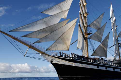
The Russian sail training vessel STS Pallada. (Pallada)

Ever since the March 11 earthquake and tsunami that devastated parts of northeastern Japan, scientists have been using computer models to track the debris that was swept out to sea by the waves.

Now a Russian sail training vessel has found the debris in mid-Pacific nearing Midway Island.

The STS Pallada was on a sail training mission when the officers and crew became aware of the computer models created by the International Pacific Research Center  at the University of Hawai at Manoa. So on its way home from Honolulu to Vladivostok the ship went looking for the debris.

The IPRC has now posted some excerpts from the Pallada’s log, as transmitted by  Natalia Borodina, the Pallada Information and Education mate.

Sept.  22 in position 31.42.21 N and 174.45.21 E we picked up on board the Japanese fishing boat.  Radioactivity normal, we’ve checked it with the Geiger counter. At approaches to the mentioned position  (maybe 10-15 minutes before)  we also sighted a TV set, fridge and a couple of home appliances.

Sept. 27 We keep sighting every day things  like wood boards, plastic bottles, buoys from fishing nets (small and big ones). an object resembling a wash basin, other wastes.  All these objects are floating by the ship.

With the data provided by the Pallada, the scientists in Hawaii are reviving the computer models of the debris drift.  They expect the debris to reach Midway sometime this winter. Some debris  will  reach the main Hawaiian Islands and eventually the west coast of North America.

593-mapdebris-thumb-500x273-592.jpgA map of the tsunami debris field by Nikolai  Maximenko and Jan Hafner of  IPRC. The line shows the track of the Pallada where the debris was spotted between  Sept. 21 and Sept. 28, 2011. The red rhombus (diamond)  marks the location where the Japanese boat  was found. The red circle  denotes maximum debris density spotted by the Pallada. The purple shows the extent of the debris field from the updated university computer model as of Sept. 25. Click for larger image. (IPRC)

595-recovery.jpg
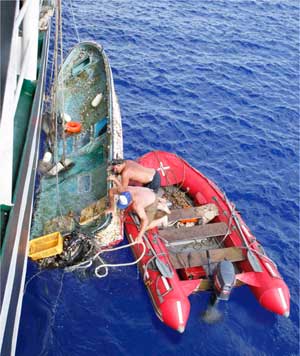
The crew of the Pallada hoists on board a Japanese boat, registered in Fukishima prefecture, and presumably washed out to sea during the March 11, 2011 tsunami. (Pallada)

IPRC/ Pallada news release  (pdf)

Enhanced by Zemanta