Special Report: New study identifies earthquake hazards for Hartley Bay, Bella Bella, Kitimat and Terrace

UPDATED with comments from District of Kitimat, Terrace and the Gitga’at Nation

A preliminary seismic hazard assessment by Natural Resources Canada has identified possible earthquake scenarios for the Douglas Channel near Hartley Bay, Terrace and Bella Bella.

The same studies indicate that while Kitimat may not be directly in a seismic zone prolonged earthquakes cause some damage in Kitimat depending on the earthquake and the condition of the soil in certain parts of the District. One model scenario says that in the event of a magnitude 8.0 earthquake off the west coast of Haida Gwaii, given certain soil conditions, there might actually be more damage in Kitimat than on the islands.

Susceptibility to landslides

That assessment, part of the overall the study by the Geological Survey of Canada indicates that the north coast of British Columbia from Prince Rupert to Bella Bella is likely face to “seismically induced ground failure”– mostly landslides.

Overall, the report says that on a scale of 1 to 6 (6 representing the highest
susceptibility), the majority of the west coast of BC “exhibits landslide susceptibility values of 5 to 6, which is significantly higher than the rest of Canada.”

Geological Survey of Canada map showing parts of Canada that are prone to landslides. The BC North Coast study area is outlined by the rectangle. (Geological Survey of Canada)

In British Columbia the landslides are most likely to be triggered by delayed melting of the annual snow pack, heavy rains, bank erosion and site loading and caused long-lasting damning of the river causing “damage to pipelines, rail, and forestry, as well as fish habitats.”

So far no recent landslides along the northern British Columbia coast are known to be caused by earthquakes, the reports say “the existence of numerous landslides strengthens the likelihood of seismically induced ground failures… due to the high levels of seismicity….it is expected that the increased likelihood of strong ground shaking (with long durations) will increase the landslide susceptibility.”

New studies

It was only after the 2012 Haida Gwaii earthquake and with what the Geological Survey of Canada calls “a growing number of on-going and planned infrastructure projects, BC’s north coast is emerging as a region of high strategic importance to Canada’s economy,” that studies began in area where “there has been minimal research to understand earthquake hazards.”

Now that studies have begun the Geological Survey has given the region its own new acronym BCNC (BC North Coast). Haida Gwaii is not part of BCNC, although earthquakes on those islands would likely impact the coast.
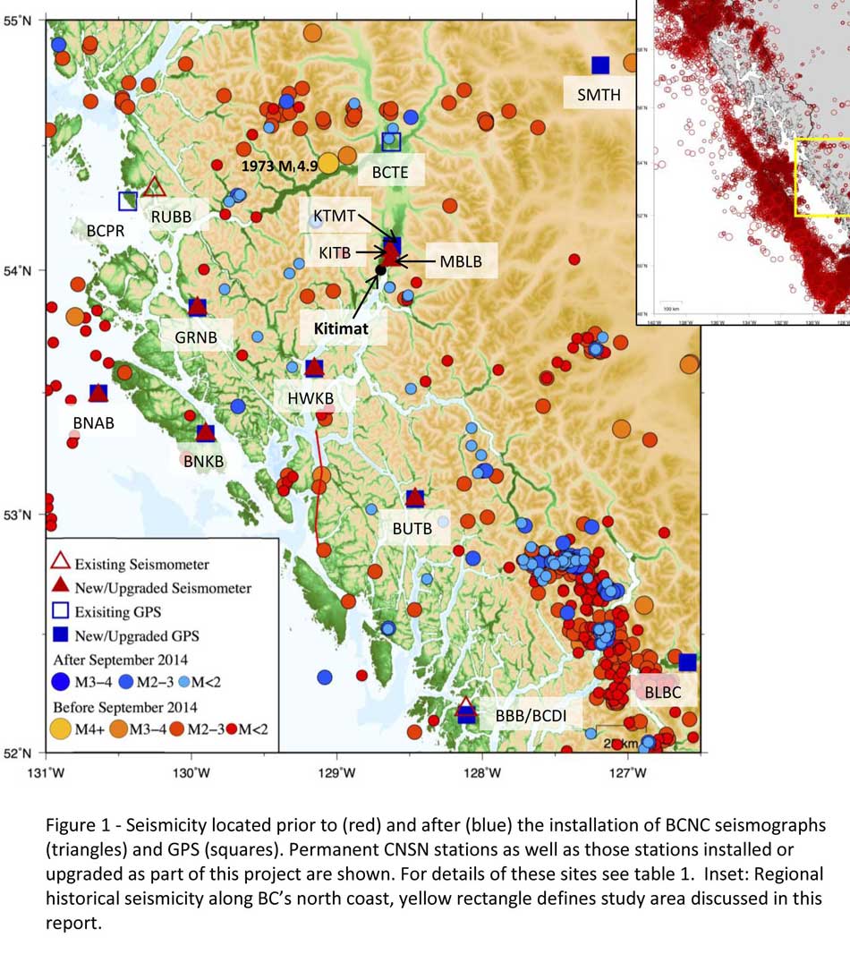
A Geological Survey of Canada map showing the BC North Coast region with earthquakes identified prior to and during recent studies. (Geological Survey of Canada)

The Geological Survey says that historically “the BCNC has been seismically quiescent.” As a result “seismic monitoring and research related to the BCNC has been minimal.” That meant while larger earthquakes were “felt and recorded,” the configuration of the Canadian National Seismograph Network did not allow earthquakes less than approximately magnitude 2.1 to be monitored in northern BC.

Now the Geological Survey is looking at “long-term, continuous monitoring of micro seismicity, combined with geodetic and paleo seismic techniques” that could be used to study at the possibility of large earthquakes, including a possible fault on the lower Douglas Channel.

Since the studies began in August 2014, the Geological Survey identified 145 earthquakes within the study area, many too small to be felt since they are less than magnitude 2.0. Those earthquakes, however, were picked up by the new and improved instrumentation used by the earthquake monitors.

The two reports one on “seismic hazards” and the second on “geohazards” says five “temporary seismonitors”  (download reports from links below) were installed within the BCNC while some older stations were upgraded, saying, “It is expected that these new stations will be aid in locating small earthquakes” that were not previously detected by the existing network. The Geological Survey also installed ground movement monitoring GPS units along the coast.

The use of the term “temporary” raises the question about how much ongoing monitoring is planned.

The study also notes that the current data is not included in the seismic standards in the current National Building Code of Canada, which in turn is based on the Natural Resources Canada Seismic Hazard Map. That may mean that municipalities in the BC North Coast region, in the future, as the seismic studies continue, may have to consider updating building codes, especially in areas of “softer soils” as opposed to harder rock.

“Fault-like structure” on Douglas Channel

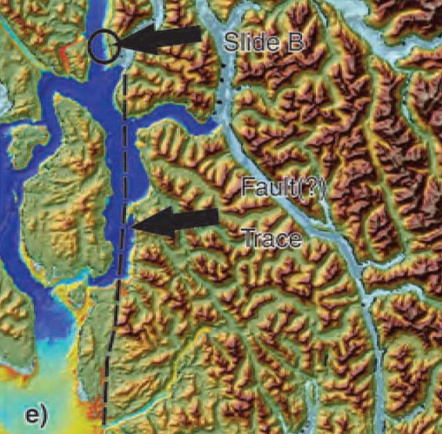
Detail of a map from the Geological Survey of Canada where the red line shows the 60 kilometre possible (still unconfirmed) fault line running from Gribbell Island to Princess Royal Island (Geological Survey of Canada)

Over the years some small earthquakes have also been recorded on what the Geological Survey calls the “recently mapped fault-like structure” on Douglas Channel which was discovered in 2012. The survey is still calling it “fault-like” because it has not yet been confirmed as an active fault. A new map in the study shows that the “fault” runs from the southern tip of Gribbell Island, down the centre of Whale Channel east of Gil Island and then along the western coast of Princess Royal Island.

The study identified “a small, unfelt swarm of earthquakes between magnitude 1.7 and 2.0 between September 13 and 14, 2010 near Gil Island.”

There is also the previously identified ancient Grenville Channel Fault (ancient and believed inactive because it dates from the Cretaceous, the age of the dinosaurs) that runs from along Grenville Channel from Porcher Island in the north to Klemtu in the south which has experienced small earthquakes.

The report says geological studies of the Douglas Channel “fault-like structure” are a priority because, “Should this structure be determined to be an active fault, it would pose significant risk of earthquake-triggered landslides (and subsequent tsunami) from the susceptible Douglas Channel hill slopes.”

Clay and sand in Kitimat

The report also calls for more studies the local geology and soil conditions in the Kitimat Valley. A study back in 1984 by John Clague of Simon Fraser University showed that as the glaciers retreated during the last Ice Age there were “periods of stagnation” resulting in sediments that are thicker than other regions of British Columbia, Clague reported that in parts of Kitimat, the glacial moraine is hundreds of metres thick.

After the glaciers were gone, the sea levels rose and glaciomarine sediments (clay, silt up to 60 metres thick) were deposited until the sea level fell to present-day levels. The report says that as these marine deposits were exposed to fresh water, salts were leached out resulting in saturated, porous sediments, including clay, which are prone to failure. Boreholes in the Kitimat area show that the clay and sediments above the bedrock can range from 17 metres to 106 metres.

The report notes the presence of clay soils “can amplify ground shaking and secondary effects” as happened in November 1988 when there was an earthquake in the Saguenay region of Quebec.

Originally reported as a 6.2 magnitude but later downgraded to 5.9, on Nov. 25, 1988, the major earthquake was centered near the Quebec cities of Chicoutimi and Jonquière, with aftershocks felt as far away as Toronto, Halifax and Boston. The quake lasted for two minutes, catching thousands of people off guard and leaving buildings damaged and power out for hundreds of thousands of Quebecers.

CBC Television reported the earthquake caused a leak of toxic gas at the Alcan Aluminum plant at Jonquière, which was quickly contained. “There was no wind, we were basically lucky,” Alcan spokesman Jacques Dubac told CBC News at the time. 

Terrace earthquake

The report says the most significant event within the BC North Coast study region (which as mentioned doesn’t include Haida Gwaii) was a magnitude 4.9 earthquake approximately 20 kilometers southwest of Terrace on November 5, 1973, which was felt as far as 120 kilometers away, with some minor damage (broken windows and cracked plaster) reported near the epicentre. The main shock at Terrace was preceded by a magnitude 2.5 foreshock four hours before, and followed by a felt magnitude 3.7 aftershock the next day.

Bella Bella at risk

Another area most at risk, according to the report, is southern part of the BC North Coast zone, near Bella Bella, which is close to the northern section  Cascadia Subduction Zone  a “1,000 kilometre long dipping fault that stretches from Northern Vancouver Island to Cape Mendocino California” which one day will cause a major earthquake along the fault.
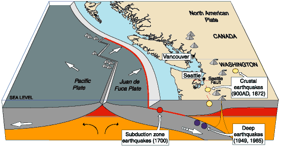
Cascadia subduction zone (USGS)

The report says that a magnitude 9.0 or higher earthquake in the northern Cascadia Subduction zone close to Bella Bella would be similar to the March 2011 earthquake in Japan and the 1964 Good Friday earthquake in Alaska.

For the northern part of the BC North Coast region, hazards could come from either a major earthquake off Haida Gwaii or a similar earthquake in south-eastern Alaska.

The greatest hazard would come from “long period” earthquakes greater than magnitude 6.75 with an epicentre between 300 and 350 kilometers away where the shaking lasts longer than one second.

The Geological Survey modeled three possible scenarios for major earthquakes in the BC North Coast Region.

Model #1. A magnitude 8.0 Earthquake at Haida Gwaii

The Geological Survey Canada model for an 8.0 magnitude earthquake west of Haida Gwaii. The possible damage is colour coded in the table below the map according to the Modified Mercalli Intensity Scale (Geological Survey of Canada)
The Geological Survey Canada model for an 8.0 magnitude earthquake west of Haida Gwaii. The possible damage is colour coded in the table below the map according to the Modified Mercalli Intensity Scale.  The red polygon represents the area of possible rupture in the model with the star representing the epicentre. (Geological Survey of Canada)

The model looked at a “plausible maximum predicted” magnitude 8.0 thrust fault earthquake off the west coast of Haida Gwaii which would be twice as strong in the fault area as the 7.8 quake on October 28, 2012 (Remember Magnitudes are based on a logarithmic scale. That means for each whole number higher, the amplitude of the ground motion recorded by a seismograph goes up ten times so magnitude 8 earthquake would result in ten times the ground shaking as a magnitude 7 earthquake)

For a short period earthquake, the report estimates that there would be minimal damage on Haida Gwaii similar to the damage from the 2012 earthquake with little or no damage on the BC North Coast.

A long duration, long period earthquake that lasted longer than one second and up to three seconds or longer “may effect taller structures and trigger ground failure (that is liquefaction and lateral shaking).” Kitimat would feel that earthquake with the worst shaking in parts of the District with what the report calls “sensitive soils.” Coastal islands would feel double the amount of shaking as would occur in Kitimat.

Model #2. A magnitude 7.2 Earthquake in Douglas Channel
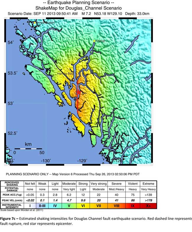
 The Geological Survey Canada model for a 7/2 magnitude earthquake in the lower Douglas Channel. The possible damage is colour coded in the table below the map according to the Modified Mercalli Intensity Scale. The red star represents the possible epicentre. (Geological Survey of Canada)

The Geological Survey Canada model for a 7/2 magnitude earthquake in the lower Douglas Channel. The possible damage is colour coded in the table below the map according to the Modified Mercalli Intensity Scale. The red star represents the possible epicentre. (Geological Survey of Canada)

The second model looked at an earthquake in Douglas Channel based on the “fault like structure” if a slip strike rupture occurred along the entire 60 kilometers of the so far unconfirmed fault, resulting in a 7.2 magnitude earthquake. There would be very strong shaking within 20 kilometers radius of the epicentre, with moderate to heavy damage” in the relatively uninhabited islands, major shaking in Hartley Bay, resulting in very strong to strong damage at Hartley Bay and strong to moderate damage in Kitimat.

That earthquake, however, would be felt across the entire province of British Columbia. The report notes:

The expected effects and impacts of such an earthquake would mimic those of the 1946 magnitude 7.3 Vancouver Island earthquake, which occurred slightly west of Courtney and Campbell River. Shaking due to the 1946 earthquake was felt as far as Prince Rupert, BC to the north and Portland, Oregon to the south. In addition to knocking down 75 per cent of the chimneys in the local area, much of the earthquake-related damage was due to landslides, slumping and liquefaction

Model #3  A magnitude 6.3 Earthquake near Terrace

 The Geological Survey Canada model for an 6.3 magnitude earthquake southwest of Terrace. The possible damage is colour coded in the table below the map according to the Modified Mercalli Intensity Scale. The red polygon represents the area of possible rupture in the model with the star representing the epicentre. (Geological Survey of Canada)

The Geological Survey Canada model for an 6.3 magnitude earthquake southwest of Terrace. The possible damage is colour coded in the table below the map according to the Modified Mercalli Intensity Scale. The red polygon represents the area of possible rupture in the model with the star representing the epicentre. (Geological Survey of Canada)

On May 11, 1973, a magnitude 4.7 shallow earthquake took place about 20 kilometers south west of Terrace, on the south side of the Skeena roughly across from the Shames mountain area. The earthquake was felt up to 120 kilometers away. The report says “The event has not been associated with any geologic features in the area and little is known about its rupture process.” The model estimated the results of a larger earthquake 6.3 magnitude in the same area. The model showed there would be strong to very strong shaking in Terrace, light to moderate shaking in Kitimat and light damage elsewhere in the BC North Coast. Most of the damage would be concentrated in a 20 kilometer zone around the epicentre.

Motivation for study

It was not just potential industrial development that motivated the new studies. The discovery of that possible fault line in the lower Douglas Channel was also a factor. Studies between 2007 and 2009 revealed there were two large submarine slides on Hawkesbury Island during the mid-Holocene sometime between 5,000 and 10,000 years ago 

The cause of the two failures is still unknown but the report says “their proximity to a nearby unmapped fault-like structure suggests that the slides could have been triggered by strong ground shaking from rupture along this structure.”

Another factor was the two well-known landslides occurred in the 1970’s in the Kitimat Arm which generated tsunamis but fortunately they occurred at low tide which decreased the impact. On October 17, 1974 a submarine slide generated a 2.8 metre tsunami. The following year on April 27, 1975, a slope failure on the northeast side of Kitimat Arm (which overlapped the 1974 failure area) displaced an estimated upper limit of 26,000,000 cubic metres of material.

“Watermark observations in Kitamaat Village estimated that the tsunami generated by this slide was up to 8.2 metres high.” The report says that while the trigger of the first event is unknown; the latter event coincided with nearby construction at that time. Modelling of the 1975 slide estimates that given the right conditions the generated tsunami waves could have been as high as 11 metres.

The report also notes that numerous landslides have also been mapped by the BC Department of Forestry in an attempt to improve safety measures for forestry workers.

The report says “The culmination of these studies brings awareness to the significant natural hazards present in the fragile coastal environment of the Coast Ranges.”

Another factor is the geology of the BC coast. The granitic mountains have rugged, steep slopes dissected by an intricate fjord system and dotted with islands of lower elevation. At lower elevations the land is covered by wet, coastal hemlock forests, which could be vulnerable to ground failures whereas higher elevations are characterized by barren rock or mountain hemlock subalpine.
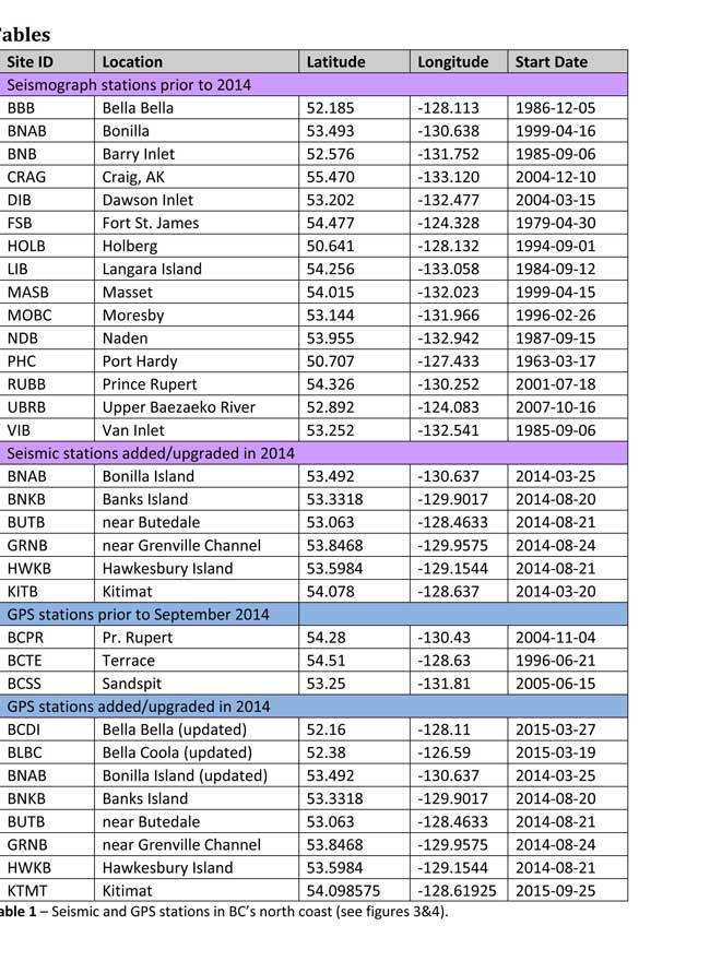
Table of Seismic monitoring and GPS stations in northern BC from the Geological Survey of Canada (Geological Survey of Canada)

The District of Kitimat said it has “not directly studied these issues but we are aware of potential hazards.” The development department has been advised of potential issues and site concerns.

A spokesperson for Terrace mayor Carol Leclerc told Northwest Coast Energy News in an e-mail. “I have reviewed it and distributed it to the relevant department heads. We are aware that historically Terrace has been at risk for experiencing seismic activity due to its location.”

The District of Kitimat did cooperate with National Resources in finding a location for their recently installed seismic equipment.

At Harley Bay, Gitga’at First Nation CEO Ellen Torng said the Gitga’at have been “ working with NRCan on their research in the Douglas Channel and in Hawksbury. NRC has been meeting with First Nations along the coast and have conducted community sessions on their research.

“We hosted one community session here in Hartley Bay and have regular updates from their technical team when they are in the area,” Torng said.

In addition, the District of Kitimat told Northwest Coast Energy News that Community Planning & Development department also provided local land information to geoscientists in the years leading up an international study called Batholiths on land in 2009.

Batholiths are large zones of molten rock that have solidified in the earth’s crust and are believed to play a key role in the formation and growth of continents. The Coast Mountain Range has a large concentration of batholiths, which means Kitimat was an excellent place to study the earth’s crust.

The project, which involved more than 50 scientists from nine Canadian and American universities, was set up to examine how mountain belts form and change over time and why continental mountain ranges are made of granite not basalt. Seismic imaging of the crust and mantle below the mountains required deploying thousands of seismic sensors and recorders, and recorded responses to several man-made detonations. Field work was completed in July 2009, and several scientific papers and dissertations have followed.

The Heiltsuk Nation was unable to respond to a request for comment due to the ongoing crisis from the sinking of the tug Nathan E. Stewart and the resulting spill of diesel fuel and other contaminants near Bella Bella.

Related Commentary: The earthshaking difference between Enbridge and LNG

Download the Geological Survey Studies (PDF)

Baseline Assessment of Seismic Hazards in British Columbia’s North Coast 2016

North Coast Geohazards 2016 Seismology Update

Modified Mercalli Intensity Scale

(from US Geological Survey )

Intensity Shaking Description/Damage
I Not felt Not felt except by a very few under especially favorable conditions.
II Weak Felt only by a few persons at rest,especially on upper floors of buildings.
III Weak Felt quite noticeably by persons indoors, especially on upper floors of buildings. Many people do not recognize it as an earthquake. Standing motor cars may rock slightly. Vibrations similar to the passing of a truck. Duration estimated.
IV Light Felt indoors by many, outdoors by few during the day. At night, some awakened. Dishes, windows, doors disturbed; walls make cracking sound. Sensation like heavy truck striking building. Standing motor cars rocked noticeably.
V Moderate Felt by nearly everyone; many awakened. Some dishes, windows broken. Unstable objects overturned. Pendulum clocks may stop.
VI Strong Felt by all, many frightened. Some heavy furniture moved; a few instances of fallen plaster. Damage slight.
VII Very strong Damage negligible in buildings of good design and construction; slight to moderate in well-built ordinary structures; considerable damage in poorly built or badly designed structures; some chimneys broken.
VIII Severe Damage slight in specially designed structures; considerable damage in ordinary substantial buildings with partial collapse. Damage great in poorly built structures. Fall of chimneys, factory stacks, columns, monuments, walls. Heavy furniture overturned.
IX Violent Damage considerable in specially designed structures; well-designed frame structures thrown out of plumb. Damage great in substantial buildings, with partial collapse. Buildings shifted off foundations.
X Extreme Some well-built wooden structures destroyed; most masonry and frame structures destroyed with foundations. Rails bent.

DFO study on ancient Douglas Channel tsunamis shows minimal impact on Kitimat, devastation at Hartley Bay

A follow up study by the Department of Fisheries and Oceans on the discovery of prehistoric slope failure tsunamis in Douglas Channel concludes that the events would have had minimal impact on Kitimat but would have destroyed Hartley Bay.

The studies were filed by DFO with the Northern Gateway Joint Review Panel on Friday, November 16, following an earlier study the Geological Survey of Canada that reported the discovery of the submarine slope failures. The filing comes just three weeks after the region was shaken by a 7.7 magnitude earthquake off Haida Gwaii and a subsequent coast-wide tsunami warning.

The DFO follow up study was aimed at better understanding the dynamics of tsunamis during the two slope failure events on the southern end of Hawkesbury Island during the mid-Holecene period, between 5,000 and10,000 years ago.

The wave dynamic model study does not address the discovery by the Geological Survey of Canada of a possible fault line along Hawkesbury Island which could have been the cause of the slope failures.

The study estimates that the wave amplitude of the first tsunami reaching the proposed Enbridge Northern Gateway terminal site near Kitimat would have been about .09 to .12 metres. Since the actual wave height hitting land from a tsunami is one half of the amplitude, the height of tsunami waves reaching Kitimat at the time would have been about 60 centimetres or 23 inches. At Hartley Bay, on the other hand, the maximum estimated wave amplitude from the second tsunami would have been 15 metres, meaning a wave height of 7.5 metres or about 25 feet.

The main reason for the difference is that both the submarine slope failures occurred south of  the dogleg in Douglas Channel at Gertrude Point. That meant the configuration of the channel from Gertrude Point up to Kitimat would lessen the amplitude whereas because Hartley Bay was so close, it would be hit by a higher amplitude. The report says that because of their relatively short wavelengths, the tsunami waves undergo multiple reflections that the “high degree of scattering from the complex shoreline and bottom topography in Douglas Channel” would “combined with the flux of tsunami energy through adjoining waterways and channels” have caused a rapid decrease in the energy of the waves with distance south and north of the slide area.

The study also points out a crucial difference between the ancient slides and the two that occurred near Kitimat in 1974 and 1975, while the land near the head of the Kitimat arm were largely composed of material laid down by the glaciers, the large slope failures on Hawkesbury Island were blocks of an extremely hard igneous rock called diorite. Each of the prehistoric slides would have consisted of about 65 million cubic metres of rock.

The DFO report says

Coastal British Columbia is an area of steep slopes, extreme seasonal variations in soil moisture, large tidal ranges, and the highest seismicity in Canada. Hazards of this form have been well documented for the coastal region of British Columbia, and other fjord regions of the world’s oceans, including Alaska and Norway. These factors increase the potential for both submarine and subaerial slope failures in the region. Such events generally take place in relatively shallow and confined inner coastal waterways, and can present hazards in terms of tsunami wave generation.

The two prehistoric submarine slides are located about 10 kilometres apart on the
slope of southern Douglas Channel, near the southern end of Hawkesbury Island

The report says:

The failures are defined by scallop-shaped hollows located along the edge of the fiord wall and appear to be associated with detached blocks that extend out several hundred metres into the channel. The two block slides identified in Douglas Channel are characteristic of rigid-body submarine landslides, which differ considerably from the well-documented viscous submarine landslides with a lower specific gravity (density relative to water) of about 1.5 that occurred to the north of Douglas Channel along the inner slope of Kitimat Arm in 1974 and 1975.

The report’s modelling is “considered minimum values” because the do not include debris that would have spread into the fiord after initial slide. That debris is now buried by a thick layer of post-slide sediment.

DFO diagram of the model of Slide A on Hawkesbury Island (DFO)

The reconstruction model shows that the head of the more northern slide began at a depth of around 60 to 100 metre, while that of the more southern slide began at a depth of 75 to 120 metres.

The slides would have moved down slope at about 25 metres per second, coming to rest after about 30 seconds, 250 to 350 metres from the slope at a depth of 400 metres.

The northern slide, called by the scientists Slide A:

would have generated extremely large waves in the immediate vicinity of the failure
region within a minute of the submarine landslide. Waves in the numerical simulations reach amplitudes of 30 to 40 metres at the coast near the slide area

Submarine landslides cause delays between the arrival of the first waves and the arrival of subsequent higher waves, increasing in distance from the slide, because of “reflections and non-linear interaction” along the shoreline. For Slide A, the maximum wave amplitudes at Hartley Bay would have been six metres (meaning three metre waves) “Large amplitude waves with typical periods of around 50 seconds would continue for several tens of minutes.”

The leading tsunami waves generated by Slide A reach Kitimat Arm in roughly 20 min and have small amplitudes of only a few centimetres. Although later waves have higher amplitudes, the maximum wave amplitudes (which occur 50-55 minnutes after the failure event) are still only around 0.09 to 0.12 metres.

The southern slide on Hawkesbury, called Slide B by the scientists, would have moved 400 metres before stopping. It stared at a greater depth than Slide A, with not as much vertical displacement than Slide A. That means Slide B was slower than Slide A.

Slide B:

would have generated large waves in the vicinity of the failure region. Simulated waves reach the coast adjacent to the slide region within a minute of the failure event, with wave amplitudes of up to 10 metres. The waves also hit the opposite site of the channel within a minute of the failure event and then take an additional minute to reach Hartley Bay where waves reach amplitudes of 15 metres/ Powerful oscillations in the bay last for tens of minutes.
Waves with high amplitudes (more than 2 metres) also occur in the southern part of Douglas Channel, and in certain locations of Verney Passage.

According to the models, the leading tsunami waves would have reached the Kitimat Arm 22 minutes after the start of the slide. The maximum waves would have had amplitudes of 0.08 metres to 0.3 metres (6 inches), reach the Kitimat Arm 45 to 60 minutes after the start of the failure event.

The the tsunami waves generated by Slide B that impact Kitimat Arm,  although still of low amplitude, were somewhat higher than those generated by Slide A, despite the fact that Slide B was located further to the south and generated less energetic waves in the source region than Slide A.

This seeming paradox is explained by the slower motion of Slide B, which causes it to generate more wave energy in the low frequency band…Due to their reduced scattering and reflection, the relatively long and lower frequency waves generated by Slide B propagate more readily through the complex fjord system than the relatively short and higher frequency waves generated by Slide A.

Specifically addressing the proposed site of the Enbridge bitumen terminal, as well as potential tanker traffic in Douglas Channel, the detailed explanation of the modelling accompanying the DFO report says:

If similar submarine slides were to occur again somewhere in the same general area, they could present a significant risk to navigation and to nearby shore installations and coastal communities….

As with the tsunami generation regions, the highest waves and strongest currents in any particular region of the coastal waterway would occur near the shoreline. Based on the numerical findings, tsunamis generated by submarine landslides of the form identified for the southern end of Douglas Channel would have heights and currents that could have major impacts on the coastline and vessel traffic at the time of the event throughout much of Douglas Channel, but a minor impact on water levels, currents and hence vessel traffic in Kitimat Arm. Hartley Bay, at the southern end of Douglas Channel, would be impacted by high waves and strong currents, whereas Kitimat, at the northern end of Kitimat Arm, would experience negligible wave effects. Additional modelling would be required to assess the characteristics of possible tsunamis originating beyond the area of the two identified slope failures.

At the estimated propagation speeds of about 65 metres per second, the detailed model says it takes roughly 10 to 15 minutes for the simulated waves to propagate approximately 40 to 45 kilometres to the intersection of Douglas Channel and Kitimat Arm, where peak wave amplitudes would be diminished to less than one metre. It takes another 15 minutes for the waves to reach sites near the proposed Enbridge facilities in Kitimat Arm where wave amplitudes would be reduced to a few tens of centimetres and associated currents to speeds less than a few tens of centimetres per second.


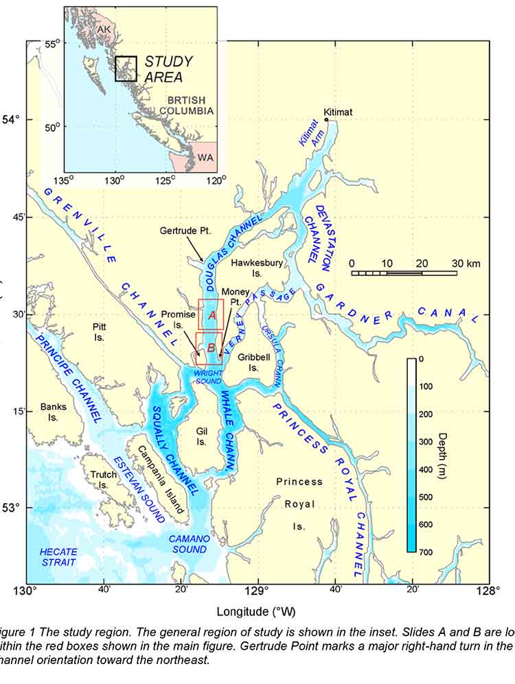
Slide tsunami area map
Slide tsunami area study map (DFO)


Fisheries and Oceans-Modelling Tsunamis Associated with Recently Identified Slope Failures in Douglas Channel  (pdf)

Numerical data for DFO tsunami study (link to JRP)


After the earthquake: Kitimat must immediately upgrade its emergency communications

As a 7.7 magnitude earthquake hit off Haida Gwaii shortly after eight o’clock on Saturday, I was at the Haisla Recreation Centre as the Haisla Nation marked the return of the G’ps Golox totem pole. Like a boat being lifted by gentle waves, the Rec Centre began to quietly roll up and down, then the rolling seemed to accelerate just a bit. I realized that it was an earthquake. As I told CBC’s Ian Hanomansing  later in the evening, I have been in a number of earthquakes, and for me at least, this quake, at least at Kitamaat Village, the rec centre was not shaking as badly as in some of the others I have felt.

The subsequent events of the evening show that the emergency communication system in Kitimat needs immediate improvement.

Cell service

Cell phone service at the village is poor and after the rolling stopped neither myself nor my Kitimat Daily colleague Walter McFarlane was able to get “bars.”

Now as a former network producer for both CBC and CTV I have handled a large number of earthquake stories from around the world over the past quarter century (sitting at a desk, I should add). With that experience, I was hoping to get a cell hit at the village so I could bring up Twitter. I already subscribe to the US Geological Survey and Canadian earthquake alert feeds. The US and Canadian computers automatically report earthquakes within seconds of detection and send out a Twitter bulletin as the same time as those computers are alerting their human masters. If I had been able to get cell service I would have known within minutes that the Haida Gwaii earthquake was a major event. (I did follow the alerts from my computer once I got back to Kitimat itself).

Recommendation One. Cell service in Kitimat, Kitamaat Village, the harbour area must be upgraded as soon as possible. Telus has applied to council to erect a new cell tower here. Given the events of the past 24 hours, District Council should make sure that all parts of the District of Kitimat and the Haisla Nation have proper cell coverage no matter what service one subscribes to, not just for the convenience of subscribers but for emergency situations.

Automatic alerts

With experience one knows that in a situation such as Saturday night, the official websites such as the US Geological Survey and the Pacific Tsunami Warning Center as well as  Natural Resources Canada are often overwhelmed. That is why the media use RSS feeds, Twitter feeds and e-mail alerts. It is also important to realize that these emergency organizations have their own language and procedures. It appears that a lot of the confusion on Saturday came from misinterpretation of the various Canadian and US warning systems.

Recommendation Two. If Kitimat emergency services are not familiar with how the US based earthquake and tsunami centres work, they should be trained in those systems, simply because the Americans are well ahead of Canada in these areas because the alerts go out by computer automatically and are constantly updated and as Saturday night showed, are often quicker and farther ahead than the Canadian systems.

Once I was back in Kitimat, it was clear that communications were breaking down, and this was at a time the tsunami warning was still active. There were numerous messages on Twitter and Facebook, from residents of Kitimat either trying to find out what was going on or retweeting/reposting rumours including one that the Kildala neighbourhood was being evacuated. I am told that residents were calling the RCMP to ask what was going on. This was another breakdown since North District HQ in Prince George handles all police services in this region and were likely busy with quake calls on Haida Gwaii, so that information calls in Kitimat that should have been handled by an emergency services public communications person were being handled the Mounties.

There were reports that one man was going door to door in Kildala telling people to evacuate. Whether this person was well intentioned but misinformed or a imposter intent on mischief doesn’t matter, there was an information vacuum.

It was clear from Twitter that other districts and municipalities were using that service to spread official information. (I don’t follow other areas on Facebook so it is unclear if information was being posted on Facebook. There was certainly no official presence from Kitimat on Facebook Saturday night.) It appears from reports in the Kitimat Daily and tweets about the Northern Sentinel that Kitimat emergency services was sending information out by fax. While faxing information was an advance in the 1980s, faxes are obsolete in 2012. Many major newsrooms no longer use fax machines after being inundated by junk faxes and after they laid off all the editorial assistants who would have cleared those fax machines (even by the late 90s most faxes were dumped in the garbage unless the EA had been told to look for a specific fax). Also though it is now more than two years since I returned to Kitimat and I regularly freelance for Global, CBC and Canadian Press, I had no contact from anyone in emergency services (also I don’t have a fax machine).

Recommendation Three: The District of Kitimat must immediately bring its emergency communications into the 21st century, with Twitter accounts, a Facebook page and an emergency e-mail or text message plan for media and other officials who can get the messages. ( A number of jurisdictions already use text messages for emergency alerts at various graduated levels, official, media, public). When the main means of communication today is social media, an emergency organization can no longer follow outdated procedures, an organization must be on social media immediately it becomes clear that there is an emergency (as we are seeing with all the official tweets with the Hurricane Sandy crisis on the east coast)

CFTK

In an emergency situation, local radio and television are vital to communications and letting people know what is going on.

CFTK did a much better job on March 27. 1964 after Kitimat felt the magnitude 9.2 Good Friday Anchorage earthquake than it did on the weekend with the Haida Gwaii earthquake.

The inadequate coverage of the quake was certainly not the fault the of the current CFTK news staff who were working hard (probably on their own time and unpaid) keeping Twitter updated with what they knew. The fault lies with corporate management across the media which these days doesn’t want to spend the money and resources and training to fulfill the public service portion of their broadcast licence mandate.

(There was a similar breakdown in the May 2000, Walkerton, Ontario e-coli crisis where the local medical officer of health was initially unable to alert the public because local radio wasn’t staffed on the weekends–the local stations were taking satellite feeds from their corporate headquarters)

In 1964, long before satellites, when the microwave towers that joined CFTK to the Canadian networks were still being built, the staff of CFTK, then, of course under local management, went to a live special within an hour of the Anchorage quake being felt far off from Alaska in Kitimat. The CFTK anchors were keeping its audience updated with “rip and read” wire copy, a camera on an atlas for a map and phone interviews.

In contrast, on this Saturday night, CFTK was taking the CBC BC network feed which was a hockey rerun (hardly a show that attracts  major audience numbers and certainly not a vital broadcast) until the CBC management in Vancouver decided to go to full network news special.

Since CFTK is the station that broadcasts not only to Kitimat, but to Haida Gwaii as well, CFTK should have been ahead of Vancouver on this story, called in its staff and mounted their own live special, joining the CBC feed when it began but, as on an election night, breaking away for local news when justified. CFTK has a responsibility under its licence from the CRTC to provide that service to the northwestern region, not just sending what ad revenue it generates back to Astral.

Rio Tinto Alcan

Another question that must be asked in this situation is where was Rio Tinto Alcan on Saturday night? In all areas that were under a tsunami warning the first scrutiny and clue if there was to be a problem is that region would be found by observing what has happening between the low tide line and the maximum hide tide line. In Prince Rupert, from the Twitter feeds I saw, public officials were monitoring the waterfront and the tide lines and updating the public. RTA has all the advantages of the private port of Kitimat. It appears that monitoring the water level at the tide lines at the port of Kitimat was the responsibility of Plant Protection. Was RTA communicating what was happening with emergency services? Since RTA runs the private port, unlike in other jurisdictions, RTA had a responsibility to the people of Kitimat to report promptly to the public the conditions on the waterfront. Corporate public relations cannot just be sending out news releases with “good news.” That means that RTA public relations should have used its corporate Twitter account which usually sends out a news release every few weeks, to keep Kitimat updated on a minute-by-minute basis. If RTA communications staff in Kitimat do not have access to the RTA corporate Twitter account, they should establish their own local Twitter feed.

Both in 1964 and in 2012, the tsunami that came up Douglas Channel was minimal. But we know that this region does have a record of major quakes and that Douglas Channel has also experienced major landslides that can, in some circumstances, trigger a tsunami without an earthquake. The next few years will be seeing more industrial development along Douglas Channel which can also bring other hazards to the Kitimat region. While there are always communications breakdowns in situations like happened on Saturday, it is clear that the Kitimat emergency communications system needs a major upgrade to make sure the public is informed quickly and accurately of what is going on.


Geological Survey of Canada identifies tsunami hazard, possible fault line on Douglas Channel

Fault zone map Douglas Chanel
A map from the Geological Survey of Canada showing the line of a possible seismic fault on Douglas Channel (Geological Survey of Canada)


Updates with statement from Natural Resources Canada, new filings by Enbridge Northern Gateway and the Attorney General of Canada (in box below)

The Geological Survey of Canada has identified a tsunami hazard and a possible seismic fault in Douglas Channel near Kitimat. A scientific paper by the Geological Survey and the Department of Fisheries and Oceans says there were once two giant landslides on Douglas Channel that triggered major tsunamis and that the landslides were possibly caused by an earthquake on the fault line.

Kitimat is the proposed site of the Enbridge Northern Gateway project and at least three liquified natural gas projects.

If the projects go ahead, hundreds of supertankers with either bitumen or LNG will be sailing in the channel for years to come.

A filing by the Attorney General of Canada with the Northern Gateway Joint Review Panel is asking the JRP for leave to file late written evidence long after the original deadline of December 2011. The Attorney General’s motion was filed on August 17, but went unnoticed until the Kitimat environmental group Douglas Channel Watch brought the matter up with District of Kitimat Council tonight (Sept. 17).

Appended to the Attorney General’s motion is a copy of a scientific paper from the Geological Survey “Submarine slope failures and tsunami hazards in coast British Columbia: Douglas Channel and Kitimat Arm” by Kim W Conway, J.V. Barrie of the Geological Survey and Richard E. Thomson of the Department of Fisheries and Oceans.

The report says the scientists discovered “evidence of large submarine slope failures in southern Douglas Channel.”

It goes on to say: “The failures comprise blocks of bedrock and related materials that appear to have been detached directly from the near shore off Hawkesbury Island.” Hawkesbury Island and many of the other islands in Douglas Channel are built up with material left over from the ice age glaciers and thus are vulnerable to displacement and landslides.

The research identified two slides, one estimated at 32 million cubic metres and a second of 31 million cubic metres. The report goes on to say that the discovery of an “apparently active fault presents the possibility that they may have been triggered by ground motion or surface rupture of the fault during past earthquake events.”

The slope failure landslides are covered with thick layers of mud, and that, the scientists say, could mean that the failures could be ancient, possibly occurring 5.000 to 10,000 years ago. Further research is needed to confirm the date of the giant slides.

What is worrying about the discovery is that fact that there were two recent submarine slope failures on the Kitimat Arm of Douglas Channel. both creating tsunamis. The first slope failure occurred on October 17, 1974, triggering a 2.4 metre tsunami at low tide. Then on April 27, 1975 there was a second slope failure near low tide on the northeast slope of the Kitimat Arm that generated an 8.2 metre tsunami. The 1975 tsunami destroyed the Northland Navigation dock near Kitimat and damaged the Haisla First Nation docks at Kitamaat Village.

The paper says that “Additional geological research is required to better delineate the age of the submarine failures, their triggers, and their mechanisms of emplacement.”

Urgent new research is underway and the filing by the Attorney General says when the Department of Justice requested leave to file late evidence says it anticipates that the further research by DFO is expected to be completed by November 1. The Natural Resources Canada Earth Sciences Sector began a national assessment of submarine slope failures in Canada in late 2011 and completion of the Pacific portion of this assessment is targeted for December of 2012.

The Attorney General’s filing says that DFO is now modelling “potential wave heights and speeds that may have resulted from the two previously unrecognized submarine slope failures in the Douglas Channel.” The model will use high resolution scans of the Douglas Channel seafloor to create the models.

The survey of Douglas Channel in 2010 suggests the possible existence of a fault immediately to the south of the second ancient slide on Hawkesbury Island.

The GSC paper says that evidence for a continuous fault was observed by aligned stream beds and fractures on the south end of Hawkesbury Island, about four kilometers from the site of the second ancient slide. The possible fault then appears to terminate far to the south near Aristazabal Island on the Inside Passage. The Geological Survey says that eleven small earthquakes, all less than magnitude three, have appeared with 20 kilometres of the suspected fault over the past 25 years.

The paper says that the scientists conclude that the slides appear to have left very steep slopes at or near the shoreline that could be susceptible to future failure events.

A large potential slope failure has been identified near one of the ancient slides….

in the absence of additional evidence, the fault must be considered a potential trigger for the submarine failure events….the triggers for the failures have not been defined; however, their proximity to a potentially active fault represents one potential source. The failures probably generated tsunamis during emplacement and conditions exist for similar failures and associated tsunamis to occur along this segment of Douglas Channel in the future.

The scientists say that detailed tsunami modelling is underway to

provide an improved understanding of the generation, propagation, attenuation, and likely coastal inundation of tsunami waves that would have been created by slides… or that could be generated from similar future events. Only through the development and application of this type of tsunami modelling will it be possible to gauge the level of hazard posed by the identified submarine slope failures to shore installations and infrastructure, or to devise ways to effectively mitigate the impacts of future such events.

The filing by the Attorney General offers to bring the scientists to the Joint Review Panel to appear as witnesses sometime during the final hearings.

The filing notes that the current evidence tendered to the JRP by Enbridge, and other parties does demonstrate the potential for marine geohazards and associated tsunami events. Enbridge’s design of the proposed Northern Gateway marine terminal and its operational plans took into consideration the current state of knowledge of geohazards including earthquakes and tsunamis at the time of filing. Enbridge has said it would undertake further geological survey during the detailed design phase for the terminal.

At the time Natural Resources Canada noted that the information provided for the Environmental Review was sufficient at that time, now the Attorney General says:

the geographic scope for potential landslide induced tsunami hazards is now better understood to extend beyond the Kitimat Arm. NRCan and DFO seek by this motion to ensure that this Panel, and the Parties before the Panel, have the most up to date information on geohazards in the Douglas Channel.


Updates: DFO report in October will clarify the tsunamis in Douglas Channel.


Statement from Natural Resources Canada

Natural Resources Canada sent this statement to Northwest Coast Energy News on September 20, 2012.

In reference to the opening paragraph of your September 18th editorial entitled Geological Survey of Canada identifies tsunami hazard: Possible fault line on Douglas Channel, we would like to clarify the following. Although the ancient large submarine slope failures which our scientists have identified may have caused tsunamis, this is not a certainty. It is important to note that Fisheries and Oceans Canada is currently studying this information to model potential wave heights and speeds.

As our report states, only through the development and application of this type of tsunami modelling will it be possible to gauge the level of hazard posed by the identified submarine slope failures to shore installations and infrastructure, or to devise ways to effectively mitigate the impacts of future such events.

 Northern Gateway response filed on August 31, 2012

Enbridge Northern Gateway filed this response to the Attorney General’s motion on August 31.

This motion of the Federal Government Participants requests permission to file late evidence consisting of a report entitled “Submarine Slope Failures and
Tsunami Hazard in Coastal British Columbia: Douglas Channel and Kitimat Arm” regarding tsunami hazard and additional modelling work based on that report.

Northern Gateway does not object to the filing of this late intervenor evidence.
It may be relevant and Northern Gateway accepts that theevidence could not be filed earlier. However, Northern Gateway would like the opportunity to conductits own additional modelling work which it would be prepared to provide to DFO for comment prior to the filing of any modelling work by DFO in this proceeding.

Attorney General response to Enbridge on September 10, 2012.

The Attorney General of Canada responded to Enbridge by saying:

Attorney General responds DFo is prepared to await filing its subseqent modelling work in these proceedings until such time as it has received, reviewed and commented upon additional modelling work as proposed by NGP Inc.

DFO nots howeverand wishes to alert the JRP that the NGP INc proposed may occasion a delay in the filing of the DFO moedling work which is now proposed for filing on or about October 31, 2012. Delivery of DFO comments as requested will depend on when DFO received the NGP Inc modelling work, the time and resources required by DFO to study and provide comments on the NGP modelling work and unforeseen factors which may have an impact upon completion the commentary. As such,

DFO is prepared to file its modeling work on or about October 31, 2012, but subject to any further direction or request by the panel.


Map of Douglas Channel
Geological Survey of Canada map of Douglas Channel showing the area surveyed which discovered the landslides and possible fault line. (Geological Survey of Canada)

;

;

Map of slides at Kitimat
Map from the Geological Survey of Canada showing the landslides on the Kitimat Arm which triggered tsunamis in 1974 and 1975 (Geological Survey of Canada)

;

;

Slide at Hawkesbury Island
Map from the Geological Survey of Canada showing the giant slide on the southern tip of Hawkesbury Island. (Geological Survey of Canada)

;

Hawkesbury Island slide map
Map from the Geological Survey of Canada showing the second giant slide on the coast of Hawkesbury Island on Douglas Channel (Geological Survey of Canada)

Department_of_Justice Notice of Motion of the Attorney General of Canada Seeking to Tender Supplementary Written Evidence (pdf)

Submarine Slope Failures and Tsunami Hazard in Coastal British Columbia Douglas Channel and Kitimat Arm PDF