Three studies of the geology of Douglas Channel are near completion and publication, according to Natural Resources Canada. That news comes as studies, released today, warn of a major megathrust earthquake on the fault west of Haida Gwaii.
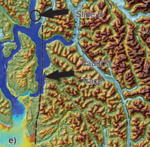
Northwest Coast Energy News asked the Geological Survey of Canada if there were any recent updates available after the agency said that a survey had located a “possible fault” on Hawkesbury Island during studies for the Enbridge Northern Gateway Joint Review Panel.
Natural Resources Canada responded with a statement: “NRCan continues to conduct research studies in the area, including study of possible faults. Three scientific expeditions have been completed on board Coast Guard research ships. The first two reports are in the final stages of editing, and will be published in the coming months. The third expedition was just completed; therefore the third report will be available later.”
More recently there were slope failures nearer to Kitimat. The first slope failure occurred on October 17, 1974, triggering a 2.4 metre tsunami at low tide. Then on April 27, 1975 there was a second slope failure near low tide on the northeast slope of the Kitimat Arm that generated an 8.2 metre tsunami. The 1975 tsunami destroyed the Northland Navigation dock near Kitimat and damaged the Haisla First Nation docks at Kitamaat Village.
Thomas James, of the Geological Survey told Northwest Coast Energy news about the team’s finding on the Haida Gwaii earthquake: “The studies focused on the Haida Gwaii and Craig earthquakes which happened at the Pacific and North American plate boundary, west of Haida Gwaii, so east of Haida Gwaii there’s no comparable plate boundaries that gives rise of historic sieismisticity.”
As well as the fact that recent studies say the mainland margin coastal zone has had very little historical seismicity, it adds no currently active faults have been identified. A study ten years ago identified some very ancient faults which have not been active since the Eocene, about 33 to 56 million years ago.
GPS studies show that in northwestern British Columbia coastal block is moving northeast at the rate of just 5 millimetres a year.
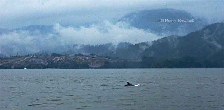
A humpback whale, seen here by its small dorsal fin, swims past the Chevron Apache KM LNG site at Bish Cove on Douglas Channel, August 21, 2013. (Robin Rowland/Northwest Coast Energy News)
Updated with comments from Gitga’at First Nation, Nathan Cullen and Shell Canada.
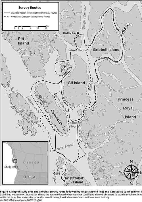
Gil Island is a “critical habitat” for the world’s humpback whales, whose numbers are increasing in Douglas Channel, Wright Sound, Estevan Sound and Camano Sound and nearby waters, according to a study released Wednesday, September 11, 2013. The study also goes on to warn that potential tanker traffic through the “geographic bottleneck” on Douglas Channel to and from Kitimat could threaten that crucial “pit stop” for the humpback whales.
The study, “Abundance and Survival of Pacific Humpback Whales in a Proposed Critical Habitat Area,” by Erin Ashe, of the University of St. Andrews, in Scotland, Janie Wray of Oceans Initiative on Pearse Island, Christopher Picard of the North Coast Caetacian Society in Hartley Bay and Rob Williams of the Gitga’at Nation Lands and Marine Resources Deptartment, is published in the jourrnal PLOS One.
The research team estimated the abundance of Pacific humpback whales by using photo-identification surveillance of adult humpbacks. They found that the number of humpback whales in this region increased each year, and doubled from 2004 to 2011, resulting in a total of 137 identifiable whales in 2011. The survey was conducted year-round. Abundance was estimated only during the summer months of July to September, when the migrating whale population is largest.
The survey focused on summer feeding regions in the northwestern BC coastal fjords that serve as a “pit stop” for whales between migrations. Migrating whales travel to the BC coast from calving grounds as far away as Mexico, Hawaii or Japan. After several months without feeding, the humpbacks arrive in BC, and, the study says, show “strong site fidelity to local feeding grounds” around the entrance to Douglas Channel.
The authors estimated that “survivorship,” the average probability of an adult whale surviving from one year to the next on the northwest coast of British Columbia is among the highest reported anywhere for the species. During “this critical refueling stage in these waters, the whales are more vulnerable to environmental stressors, such as those potentially created by increasing tourism and industrial development in the region.”
The study also says that study area has also been identified as candidate critical habitat for northern resident killer whales and notes the region “has been recolonized by fin whales in recent years.” (With details on the fin whales to come in future studies)
The study estimates there were once about 15,000 humpback whales in the North Pacific when whalers began hunting the animals. That number was down to 1,400 when whale hunting was stopped in Canada in 1966. “It is therefore good news that the segment of the population using our study area is growing and adult survival is near the limit that one would expect for this species. That said, although the population is recovering, there is no evidence that it has yet fully recovered to pre-exploitation levels in BC and we do not wish to become complacent.” the study says.
It goes on to say:
Humpback whales may be facing increasing threats in at least one of their proposed critical habitats in BC. Numerous port facility expansions and new terminal proposals, including numerous crude oil and liquefied natural gas (LNG) export proposals, could substantially increase deep-sea shipping traffic through BC’s north and central coast waters. Such developments could exacerbate oil spill, acoustic disturbance, and ship strike risks to humpbacks. In particular, the Gil Island proposed critical habitat area where our work was conducted, spatially corresponds with all shipping routes leading to Kitimat, BC port facilities that are currently being considered by regulatory agencies for high-volume crude oil and LNG tanker traffic and other increased shipping activities.
The monitoring program showed that “a relatively large fraction of BC’s humpback whales rely on the waters around Gil Island, given the small size of the study area.”
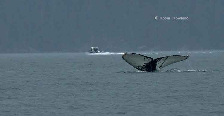
The tail fins of a humpback whale are seen in Douglas Channel near Bish Cove, as a fishing boat speeds toward Kitimat harbour in a rain storm on Aug. 21, 2013. (Robin Rowland/Northwest Coast Energy News)
The study warns:
This high reliance on relatively small fractions of available habitat has important implications for conservation and management. It lends support to the proposal to designate the current study area as part of the population’s critical habitat…
This also suggests that area-based management for cetaceans can effectively target small areas if these areas are chosen carefully. The corollary to this, though, is that a tendency for animals to be concentrated or aggregated in small areas lends them vulnerable to catastrophic events like oil spills and ship strikes. Critical habitats like the Gil Island waters are therefore a mixed blessing when high densities of whales are found in geographic bottlenecks that also funnel and concentrate shipping traffic. Anthropogenic threats to this must be evaluated not only in terms of the proportion of available habitat that this area represents, but also in terms of its critical importance to large numbers of whales for critical life-history processes. The risk and ecological consequences of an oil spill in this region would increase substantially if proposals were approved to ship large volumes of oil and LNG traffic through the Gil Island waters. Studies in Pacific waters similar to our study area suggest that oil spills can have severe and chronic impacts to cetacean populations and it is uncertain whether affected populations can recover from such perturbations.
One reason for the study is that while the humpback is considered an endangered species in the United States, in Canada it is listed as “threatened” under Canada’s Species at Risk Act and the increasing numbers could mean that the humpback is downgraded to “special concern.”
The study was based on what is called “community based science,” a cost-effective partnership between scientists, the Gitga’at Nation and other First Nations, NGOs and the Department of Fisheries and Oceans.
As part of its Pacific humpback whale recovery strategy, DFO has proposed four areas as candidate critical habitat. One criterion for designating critical habitats within northern BC coast feeding grounds is that inlets are used for specialized ‘‘bubble-net’’ feeding behaviour (where the humpbacks create a fishing net of bubbles to catch their prey).
At the start of the study, the team had noted that “mainland inlets have been somewhat under-represented in habitat studies” and so they began working on the photo-identification of the humpbacks, using two research groups, the North Coast Cetacean Society and the Gitga’at Lands and Marine Resources Department. Surveys were conducted as weather permitted throughout the year from April to November (with occasional trips in February, March and December), from 2004 to 2011.
The aim of the study was to “collect as many high-quality photographs of individually recognizable humpback whales as possible within the study area [referred to in the study as ‘Gil Island waters’’] from Estevan Sound in the west to Ursula Channel in the east. One 27 foot and one 18 foot boat were used to conduct the surveys. A total of 374 photo- identification surveys conducted over 47 months resulted in a catalogue of 177 high-quality, unique identifications of individual humpback whales.
Information also came from “an informal sightings network including local fishermen and tourism operators who reported humpback and killer whale sightings over VHF radio;” hydrophones monitored for vocalizing humpback whales; and visual monitoring from the land-based Cetacealab facility on the south end of Gil Island.
When a humpback was sighted, they were identified by the fingerprint like tail flukes and the numbers cataloged.
The study was funded by grants to Cetacealab and Gitga’at First Nation from Julie Walters and Sam Rose, and from Fisheries and Oceans Canada (Cetacean Research Program, Species at Risk Program). There was also support from King Pacific Lodge.
–
“The importance of our territorial waters for humpback and other species of whales, should give pause to those who would propose tanker routes through the Douglas Channel,” said Arnold Clifton, Chief Councillor of the Gitga’at First Nation. “The increase in whales in our territory coincides with low shipping traffic, however current proposals would increase shipping traffic to unprecedented levels. We remain resolute in our determination to protect whales and the natural heritage of our territory from tankers and other developments that would put them at risk.”
“Our study shows that while still vulnerable, humpback whales are recovering, and this area plays an important role in supporting their numbers,” said lead author, Erin Ashe, a PhD candidate at the University of St. Andrews and a co-founder of Oceans Initiative. “Identifying and protecting critical habitat is one of the most effective ways to support endangered species recovery.”
The waters around Gil Island are especially rich habitat for humpback whales, due to high abundance of their preferred foods, such as krill and herring and due to the remote nature of the coastal fjords. Humpbacks, which rely on acoustic communication, are sensitive to noise pollution from ship traffic.
“It is Cetacea Lab’s contention that all levels of government must collaborate with the Gitga’at First Nation and others in protecting humpback whales from the risk of increased tanker traffic,” said Janie Wray, whale researcher with Cetacea Lab. “This study represents the best available scientific information about the importance of this area to humpback whales. Over the course of our study, we have observed the population more than double, with mothers returning year after year with their calves, introducing the next generation of juvenile whales to the nutrient-rich feeding grounds of Douglas Channel to Caamano Sound.”
In his biweekly conference call with Northwest BC reporters, Skeena Bulkley Valley MP Nathan Cullen said: “I don’t get a sense from the way that the federal government has designed this [referring to Enbridge Northern Gateway] project, that on the marine side, any of these things are important to Mr. Harper. When you start to place down the most important values and certainly for British Columbians and Canadians, protecting a humpback feeding ground would seem like an important value in the Great Bear Rainforest, you start to see where the limits and the restrictions are on any idea of moving oil super tankers through such a narrow place. It’s just another bit of evidence, a bit of science that says this is difficult, if not impossible, and Enbridge’s project has made so many of those arguments more and more clear as we start to bring science to the table.
“It’s so frustrating for people that evidence, our opinions and our values just don’t seem to matter to the federal government. They already said yes to this thing years ago and damn the science, damn anything that comes their way. That’s not going to work, not going to work for us and not going to work for the humpback whales.”
A spokesperson for Shell’s LNG Canada project, noting that the company officials had not yet read the study, said, “It’s early days for the proposed project and the start of a thorough regulatory process. We welcome contributions and thoughts on important matters. We will look at this study. As with any project in Canada we work with local First Nations and local communities to minimize the impact of our activities.”
Neither Enbridge Northern Gateway nor Apache, a partner in the KM LNG project, responded to a request for comment.
The Canadian Coast Guard says it will undertake “a significant environmental response operation” because more oil is leaking from the sunken Second World War United States Army Transport vessel, the Brigadier General M.G. Zalinski.
Hot tapping is a well-known and frequently used method of removing oil from the tanks of stricken vessels. Holes are carefully drilled into the side of the vessel to access fuel-tanks and then hot steam is pumped into the tanks. The steam increases the temperature of the oil and enables it to flow more easily. The oil is then pumped to the surface for safe disposal.
The procedure can be done with holes of very small sizes up to very large diameters. Hot tapping is used in both marine and land-based scenarios.
The red sections in the image above represent the fuel tanks of the Zalinski; the possible locations for hot tapping of the vessel. The yellow sections represent the cargo holds. (Canadian Coast Guard)
The Canadian Coast Guard says it “has engaged the Gitga’at First Nation and the Province of British Columbia to participate in the operation and maintain a presence at the wreck site” and will keep the Gitga’at First Nation informed of what is going on:
The Coast Guard recognizes that given their proximity to the Zalinski site and their interest in the oil recovery operation, the Gitga’at need to be informed on the progress of the operation and that they have important local knowledge and skill that will be beneficial to the operation.
The Coast Guard says that environmental monitoring in January and March of 2013, discovered “further upwelling” of oil and added new patches to the sunken vessel.
The Coast Guard says: “Although the patches from 2012 and 2013 remain in place, early patches have begun to leak and the Canadian Coast Guard has determined that the structural integrity of the vessel is deteriorating.”
USAT Brigadier General M.G. Zalinski (Canadian Coast Guard)
The USAT Brigadier General M.G. Zalinski was built in 1919 and served as a United States Army Transport vessel during the Second World War. It ran aground during a storm and sank in 1946 in the Grenville Channel about 100 kilometres south of Prince Rupert.
According to a Coast Guard News release, the wreck was “undetected” until the fall of 2003 in 34 metres of water near an underwater cliff about 20 metres from shore.
In September 2003, the United States Coast Guard Cutter Maple reported pollution in the Grenville Channel to the Canadian Coast Guard.
The CCGS Tanu investigated the source of the pollution and collected oil samples, but, the news release says, the vessel remained elusive and undetected.
A month later, more oil pollution was spotted so the Canadian Coast Guard used a remotely operated underwater vehicle which located the Zalinski.
New pollution was reported in the channel in October 2003 by a commercial airline pilot and at this time the Coast Guard suspected that the source of the upwelling of oil was an old wreck.
In 2003 and 2004, the Canadian Coast Guard contracted divers to patch the vessel to prevent the leak of oil.
The Coast Guard says it regularly monitored the site with the help of Transport Canada’s National Aerial Surveillance Program. Local First Nations Groups also monitored the wreck site.
More oil was spotted in April 2012, and at that time, contract divers patched the Zalinski with an epoxy that hardens underwater.
The Coast Guard says new dive footage has shown that metal rivets that hold the hull’s plates are corroding and that the hull is buckling.
as the state of the vessel deteriorates, the Coast Guard has determined that to prevent any harm to the environment, a significant operation should be undertaken to remove the oil from the vessel. The Canadian Coast Guard will be the on-scene commander for the duration of the operation, directing the recovery and the removal of marine pollutants from the vessel and actively monitoring the operation.
The Canadian Coast Guard has also engaged the province of British Columbia and local First Nations groups to solicit their feedback on the operation. On July 26, 2013, Public Works and Government Services Canada posted two requests for proposal seeking a third-party to conduct the oil removal operation and oil spill response services to assist in the case that any oil leaks from the vessel as the operation progresses.
Wreck sites for M.G. Zalinksi and Queen of the North (Canadian Coast Guard)
It is expected that the operation will begin in September 2013 and will conclude in December 2013. The Coast Guard says because the Grenville Channel is so narrow, some restrictions on vessel traffic in the Inland Passage will be needed.
The Grenville Channel is a narrow fjord-like waterway with significant tidal fluctuations and currents up to three knots. The shoreline is rocky and steep with little shoreline vegetation.
The Grenville Channel sees commercial fishing vessels, ferries, cruise ships, and pleasure craft transiting its waters on a regular basis, with increased frequency in the summer months. These waters, naturally shielded from stronger offshore winds and weather conditions, are the preferred route of many cruise ships.
The more mild sailing conditions and the stunning natural beauty of the area make the Grenville channel one of the scenic highlights of many marine travellers on Canada’s West Coast.
Oil slick in Grenville Channel (Gitga`at First Nation Guardians)
The Gitga’at First Nation at Hartley Bay report that a large oil slick has been spotted in Grenville Channel near Hartley Bay. It is believed that the oil is coming from the USAT Brigadier General M.G. Zalinski, a U.S. army transport ship that sank in 1946 with 700 tonnes of bunker fuel on board.
A news release from the Gitga’at says the oil spill is between between two and five miles (four to eight kilometres) long and 200 feet wide (70 metres) inside the Grenville Channel.
A Canadian Coast Guard vessel from Prince Rupert is expected in the area sometime this afternoon.
The Gitga’at are sending their own Guardians to take samples and have chartered a plane to take aerial photos of the spill, the release says.
“If this spill is as big as the pilots are reporting, then we’re looking at serious environmental impacts, including threats to our traditional shellfish harvesting areas,” says Arnold Clifton, Chief Councillor of the Gitga’at Nation. “We need an immediate and full clean-up response from the federal government ASAP.”
The USAT Brigadier General M.G. Zalinski was carrying Bunker C when it sank. The First Nation says the Canadian government has been saying it would remove the oil and munitions from the ship since 2006, but with no results.
“Right now we’re focused on getting a handle on the size of the spill and the clean-up that’s required,” says Clifton. “But this incident definitely raises questions about the federal government’s ability to guard against oil spills and to honour its clean-up obligations. As a result, our nation has serious concerns about any proposal to have tankers travel through our coastal waters, including the Enbridge proposal.”
The spill is just the latest in a series of spills of bunker oil and diesel coming from the Zalinski and the BC Ferry Queen of the North, which sank in 2006. Despite government assurances of clean-up, both wreckages continue to leak fuel, fouling the marine environment, and heightening the fear of future oil spills.
The Gitga’at depend on the ocean for 40 per cent of their traditional diet.
According to Wikipedia, the Zalinksi was enroute from Seattle to Whittier Island, Alaska, when it struck rocks at Pitt Island on Grenville Channel 0n September 26 1946, 55 miles (88 kilometres) south of Prince Rupert. The ship sank within twenty minutes, while her crew of 48 were rescued by the tug Sally N and the passenger steamer SS Catala. According to a report in The Vancouver Sun on September 30, 1946, at the time of her sinking she was transporting a cargo of at least twelve 500-pound (230 kg) bombs, large amounts of .30 and .50 caliber ammunition, at least 700 tonnes of bunker oil, and truck axles with army type tires.
Oil was first spotted leaking in Grenville Channel in 2003 and the wreck of the Zalinski was identified later that year by a remotely operated undersea vessel.
Hartley Bay is the entrance to Douglas Channel where tankers will go to Kitimat for the proposed Northern Gateway pipeline and three liquified natural gas projects.
The Northern Gateway Joint Review panel has made major changes to the hearing schedule.
Originally the schedule called for ten days of hearings in Prince Rupert. There are now seven days of hearings at Kitkatla, but not on consecutive dates.
Second update Feb. 1, 2012 The hearings at Bella Bella Feb. 3 and on Feb. 4, have been rescheduled to April 2 and 3, 2012. The Heiltsuk say the request to reschedule the hearings was made because key individuals important to the oral evidence were out of town on other commitments on the original February dates.
The hearings at Hartley Bay will take place on March 3 and 4 at a location to be confirmed.
At Kitkala, the hearings will be held on March 9. 12, 13, 14, 15, 16 and 19 at Lach Klan School William Shaw Memorial Gymnasium.