Most historians and archaeologists believe that the First Peoples to arrive in North America came down the West Coast on what they now call the “kelp highway.”
Evidence from archaeological sites from the British Columbia coast to the southern tip of South America show that First Peoples had settled on both continents by at least 18,000 years ago, according to authors T.J. Braje at San Diego State University in San Diego, CA; T.D. Dillehay at Vanderbilt University in Nashville, TN; J.M. Erlandson at University of Oregon in Eugene, OR; R.G. Klein at Stanford University in Stanford, CA; T.C. Rick at National Museum of Natural History, Smithsonian Institution in Washington, DC.
The paper also says the DNA genomic data suggests a northeast Asian origin for Native American ancestors some time in the past 20,000 years.
(Science)
One of the key sites cited in the paper is Triquet Island in the traditional territory of the Heiltsuk Nation which has been dated to at least 14,000 years ago. Heiltsuk oral history has marked the island for generations, William Housty a member of the Heiltsuk told CBC News at the time the discovery was officially announced in April 2017, “Heiltsuk oral history talks of a strip of land in that area where the excavation took place. It was a place that never froze during the ice age and it was place where our ancestors flocked to for survival.”
The authors of the review say the new consensus on the “kelp highway” is a “dramatic intellectual turnabout” from the original idea that the first indigenous settlers followed an ice free corridor from a land bridge from Siberia down the centre of North America to form the “Clovis Culture”
The land bridge between northeast Asia and North America, commonly called Beringia, came about when sea levels fell during the last ice age. Although the original Beringia hypothesis has been disputed by some First Peoples, the paper says the Beringia hypothesis is still a factor—but much farther back in time, now about 24,000 years ago.
The paper says:
most archaeologists and other scholars now believe that the earliest Americans followed Pacific Rim shorelines from northeast Asia to Beringia and the Americas.
According to the kelp highway hypothesis, deglaciation of the outer coast of North America’s Pacific Northwest about 17,000 years ago created a possible coastal corridor rich in aquatic and terrestrial resources along the Pacific Coast, with productive kelp forest and estuary ecosystems at sea level and no major geographic barriers
The paper says that kelp resources extended as far south as Baja California, and then—after a gap in Central America, where productive mangrove and other aquatic habitats were available—picked up again in northern Peru, where the cold, nutrient-rich waters from the Humboldt Current supported kelp forests as far south as Tierra del Fuego.
The other sites cited in the paper are
Huca Prieta, Peru 15,000 to 14,500 years ago
Paisley Caves, Oregon 14,000 years ago
Monte Verde, Chile 14,500 years ago
Page-Ladson, Florida 14,500 years ago
Channel Islands California 13,000 years ago
Quebrada Santa Julia and Quebrada Huentelauquén , Chile 13,000 years ago
Quebrada Tacahuay Peru 13,000 years ago
Quebrada Jaquay, Peru 13,000 years ago
In an earlier article in Science in August, Knut Fladmark, a professor emeritus of archaeology at Simon Fraser University who was one of the first to propose a coastal migration into the Americas back in 1979, said: “The land-sea interface is one of the richest habitats anywhere in the world,” noting that early Americans knew how to take full advantage of its abundant resources.
Testing the kelp highway hypothesis is challenging, the scientists say, because much of the archaeological evidence would have been submerged by rising seas since the end of the last “glacial maximum,” about 26,500 years ago.
The earlier that the First Peoples arrived, that means the land they originally settled is now the further offshore from the current coast (land which is now likely also at greater depth under the current ocean). So the review says that finding the evidence means that, “enlarging already vast potential search areas on the submerged continental shelf.”
The authors say:
Although direct evidence of a maritime pre-Clovis dispersal has yet to emerge, recent discoveries confirm that late Pleistocene archaeological sites can be found underwater. Recent discoveries at the Page-Ladson site, in Florida produced 14,500-year-old butchered mastodon bones and chipped stone tools in the bottom of Florida’s Aucilla River.
The report says that “Several multidisciplinary studies are currently mapping and exploring the submerged landscapes of North America’s Pacific and Gulf of Mexico coasts, searching for submerged sites. .
In British Columbia, those studies (pdf) include the discovery by Daryl Fedje, an archaeologist at the University of Victoria and the Hakai Institute of 29 footprints on Quadra Island. A piece of wood embedded in a footprint’s fill provided the radiocarbon date of 13,200 years ago and the spear points lying and a cluster of bear bones at Gaadu Din cave on the Haida Gwaii dated to 12,700 years ago.
The review says that for much of the 20th century, most archaeologists believed humans first colonized the Americas about 13,500 years ago via the overland route that crossed Beringia and followed a long and narrow, mostly ice-free corridor to the vast plains of central North America. There, according to the earlier theories, Clovis people and their descendants hunted large game and spread rapidly through the New World.
This was initially confirmed by twentieth-century discoveries of distinctive Clovis artifacts throughout North America. Some finds associated with mammoth or mastodon kill sites, supported this “Clovis-first” model.
The early studies decided then that “North America’s coastlines and their rich marine, estuarine, riverine, and terrestrial ecosystems were peripheral to the story of how and when the Americas were first settled by humans.”
Now the recent work along the Pacific coastlines of North and South America has revealed that these environments were settled early and continuously, providing a rich diversity of subsistence options and technological resources for New World hunter-gatherers.
A detail of the map from Science shows how off from the current coast the ancient shorelines reached (Science)
At the moment, there is little evidence on the coast so far of the kind of stone tools and fishtail points that had previously provided a road map that archaeologists used to trace the spread of “Clovis” Paleoindians throughout the Americas. Such a roadmap is lacking for “pre-Clovis” sites on the coast.
One proposal is that distinctive stemmed (“tanged”) chipped-stone projectile points, crescents (lunate-shaped), and leaf-shaped bifaces found in Japan, northeast Asia, western North America, and South America could be potential markers of an earlier coastal migration and ties to Ice Age peoples in East Asia.
The problem of finding final proof of the kelp highway is that the First Peoples followed a coastal route from Asia to the Americas, so that finding evidence for their earliest settlements will require careful consideration of the effects of sea level rise and coastal landscape evolution on local and regional archaeological records.
The scientists note that around the globe, evidence for coastal occupations between about 50,000 and 15,000 years ago are rare because of postglacial sea level rise, marine erosion, and shorelines that have migrated tens or even hundreds of kilometers from their locations at the ice age glacial maximum.
They say overcoming these obstacles requires interdisciplinary research focused on coastal areas with relatively steep offshore bathymetry, formerly glaciated areas where ancient shorelines have not shifted so dramatically, or the submerged landscapes that are one of the last frontiers for archaeology in the Americas
UPDATED with comments from District of Kitimat, Terrace and the Gitga’at Nation
A preliminary seismic hazard assessment by Natural Resources Canada has identified possible earthquake scenarios for the Douglas Channel near Hartley Bay, Terrace and Bella Bella.
The same studies indicate that while Kitimat may not be directly in a seismic zone prolonged earthquakes cause some damage in Kitimat depending on the earthquake and the condition of the soil in certain parts of the District. One model scenario says that in the event of a magnitude 8.0 earthquake off the west coast of Haida Gwaii, given certain soil conditions, there might actually be more damage in Kitimat than on the islands.
Susceptibility to landslides
That assessment, part of the overall the study by the Geological Survey of Canada indicates that the north coast of British Columbia from Prince Rupert to Bella Bella is likely face to “seismically induced ground failure”– mostly landslides.
Overall, the report says that on a scale of 1 to 6 (6 representing the highest
susceptibility), the majority of the west coast of BC “exhibits landslide susceptibility values of 5 to 6, which is significantly higher than the rest of Canada.”
Geological Survey of Canada map showing parts of Canada that are prone to landslides. The BC North Coast study area is outlined by the rectangle. (Geological Survey of Canada)
In British Columbia the landslides are most likely to be triggered by delayed melting of the annual snow pack, heavy rains, bank erosion and site loading and caused long-lasting damning of the river causing “damage to pipelines, rail, and forestry, as well as fish habitats.”
So far no recent landslides along the northern British Columbia coast are known to be caused by earthquakes, the reports say “the existence of numerous landslides strengthens the likelihood of seismically induced ground failures… due to the high levels of seismicity….it is expected that the increased likelihood of strong ground shaking (with long durations) will increase the landslide susceptibility.”
New studies
It was only after the 2012 Haida Gwaii earthquake and with what the Geological Survey of Canada calls “a growing number of on-going and planned infrastructure projects, BC’s north coast is emerging as a region of high strategic importance to Canada’s economy,” that studies began in area where “there has been minimal research to understand earthquake hazards.”
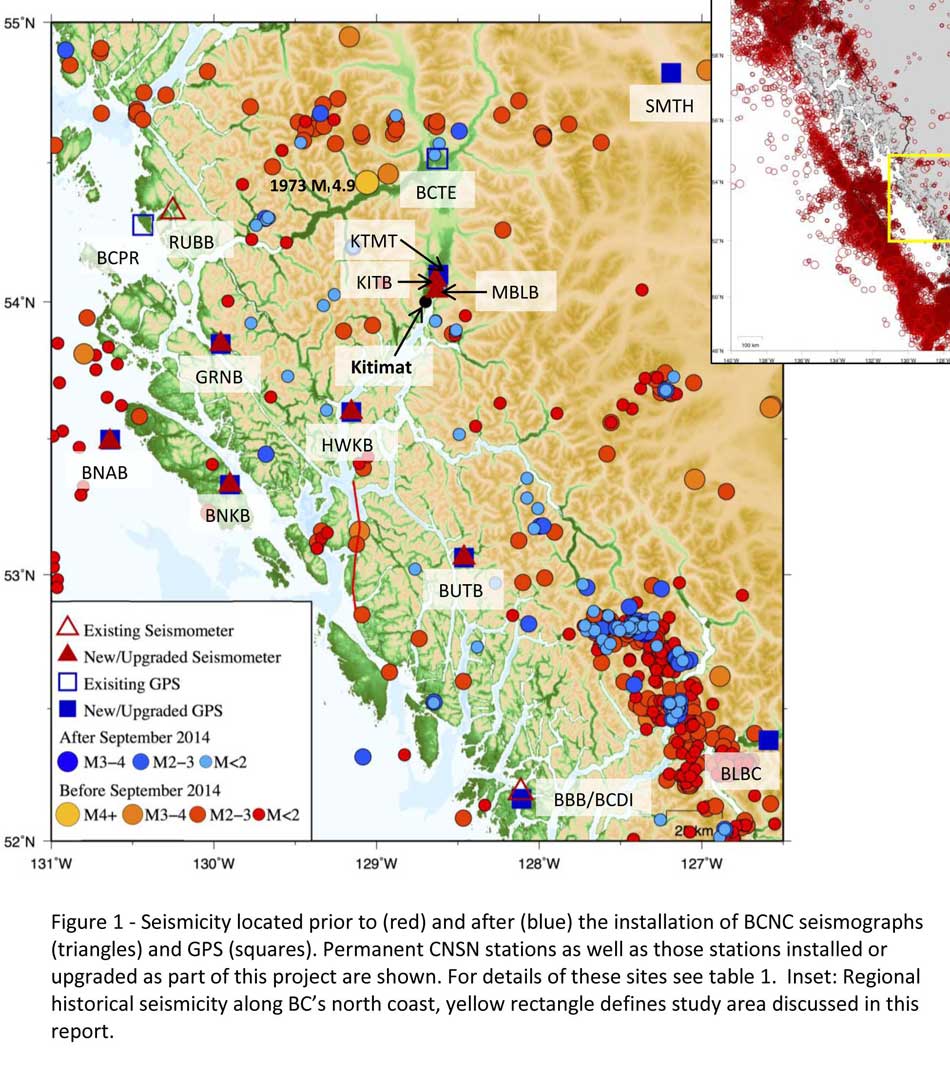
Now that studies have begun the Geological Survey has given the region its own new acronym BCNC (BC North Coast). Haida Gwaii is not part of BCNC, although earthquakes on those islands would likely impact the coast.
A Geological Survey of Canada map showing the BC North Coast region with earthquakes identified prior to and during recent studies. (Geological Survey of Canada)
The Geological Survey says that historically “the BCNC has been seismically quiescent.” As a result “seismic monitoring and research related to the BCNC has been minimal.” That meant while larger earthquakes were “felt and recorded,” the configuration of the Canadian National Seismograph Network did not allow earthquakes less than approximately magnitude 2.1 to be monitored in northern BC.
Now the Geological Survey is looking at “long-term, continuous monitoring of micro seismicity, combined with geodetic and paleo seismic techniques” that could be used to study at the possibility of large earthquakes, including a possible fault on the lower Douglas Channel.
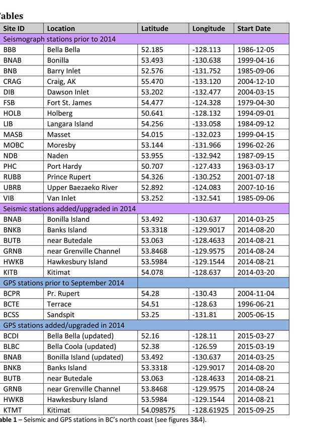
Since the studies began in August 2014, the Geological Survey identified 145 earthquakes within the study area, many too small to be felt since they are less than magnitude 2.0. Those earthquakes, however, were picked up by the new and improved instrumentation used by the earthquake monitors.
The two reports one on “seismic hazards” and the second on “geohazards” says five “temporary seismonitors” (download reports from links below) were installed within the BCNC while some older stations were upgraded, saying, “It is expected that these new stations will be aid in locating small earthquakes” that were not previously detected by the existing network. The Geological Survey also installed ground movement monitoring GPS units along the coast.
The use of the term “temporary” raises the question about how much ongoing monitoring is planned.
The study also notes that the current data is not included in the seismic standards in the current National Building Code of Canada, which in turn is based on the Natural Resources Canada Seismic Hazard Map. That may mean that municipalities in the BC North Coast region, in the future, as the seismic studies continue, may have to consider updating building codes, especially in areas of “softer soils” as opposed to harder rock.
“Fault-like structure” on Douglas Channel
Detail of a map from the Geological Survey of Canada where the red line shows the 60 kilometre possible (still unconfirmed) fault line running from Gribbell Island to Princess Royal Island (Geological Survey of Canada)
Over the years some small earthquakes have also been recorded on what the Geological Survey calls the “recently mapped fault-like structure” on Douglas Channel which was discovered in 2012. The survey is still calling it “fault-like” because it has not yet been confirmed as an active fault. A new map in the study shows that the “fault” runs from the southern tip of Gribbell Island, down the centre of Whale Channel east of Gil Island and then along the western coast of Princess Royal Island.
The study identified “a small, unfelt swarm of earthquakes between magnitude 1.7 and 2.0 between September 13 and 14, 2010 near Gil Island.”
There is also the previously identified ancient Grenville Channel Fault (ancient and believed inactive because it dates from the Cretaceous, the age of the dinosaurs) that runs from along Grenville Channel from Porcher Island in the north to Klemtu in the south which has experienced small earthquakes.
The report says geological studies of the Douglas Channel “fault-like structure” are a priority because, “Should this structure be determined to be an active fault, it would pose significant risk of earthquake-triggered landslides (and subsequent tsunami) from the susceptible Douglas Channel hill slopes.”
Clay and sand in Kitimat
The report also calls for more studies the local geology and soil conditions in the Kitimat Valley. A study back in 1984 by John Clague of Simon Fraser University showed that as the glaciers retreated during the last Ice Age there were “periods of stagnation” resulting in sediments that are thicker than other regions of British Columbia, Clague reported that in parts of Kitimat, the glacial moraine is hundreds of metres thick.
After the glaciers were gone, the sea levels rose and glaciomarine sediments (clay, silt up to 60 metres thick) were deposited until the sea level fell to present-day levels. The report says that as these marine deposits were exposed to fresh water, salts were leached out resulting in saturated, porous sediments, including clay, which are prone to failure. Boreholes in the Kitimat area show that the clay and sediments above the bedrock can range from 17 metres to 106 metres.
The report notes the presence of clay soils “can amplify ground shaking and secondary effects” as happened in November 1988 when there was an earthquake in the Saguenay region of Quebec.
Originally reported as a 6.2 magnitude but later downgraded to 5.9, on Nov. 25, 1988, the major earthquake was centered near the Quebec cities of Chicoutimi and Jonquière, with aftershocks felt as far away as Toronto, Halifax and Boston. The quake lasted for two minutes, catching thousands of people off guard and leaving buildings damaged and power out for hundreds of thousands of Quebecers.
The report says the most significant event within the BC North Coast study region (which as mentioned doesn’t include Haida Gwaii) was a magnitude 4.9 earthquake approximately 20 kilometers southwest of Terrace on November 5, 1973, which was felt as far as 120 kilometers away, with some minor damage (broken windows and cracked plaster) reported near the epicentre. The main shock at Terrace was preceded by a magnitude 2.5 foreshock four hours before, and followed by a felt magnitude 3.7 aftershock the next day.
Bella Bella at risk
Another area most at risk, according to the report, is southern part of the BC North Coast zone, near Bella Bella, which is close to the northern section Cascadia Subduction Zone a “1,000 kilometre long dipping fault that stretches from Northern Vancouver Island to Cape Mendocino California” which one day will cause a major earthquake along the fault.
Cascadia subduction zone (USGS)
The report says that a magnitude 9.0 or higher earthquake in the northern Cascadia Subduction zone close to Bella Bella would be similar to the March 2011 earthquake in Japan and the 1964 Good Friday earthquake in Alaska.
For the northern part of the BC North Coast region, hazards could come from either a major earthquake off Haida Gwaii or a similar earthquake in south-eastern Alaska.
The greatest hazard would come from “long period” earthquakes greater than magnitude 6.75 with an epicentre between 300 and 350 kilometers away where the shaking lasts longer than one second.
The Geological Survey modeled three possible scenarios for major earthquakes in the BC North Coast Region.
Model #1. A magnitude 8.0 Earthquake at Haida Gwaii
The Geological Survey Canada model for an 8.0 magnitude earthquake west of Haida Gwaii. The possible damage is colour coded in the table below the map according to the Modified Mercalli Intensity Scale. The red polygon represents the area of possible rupture in the model with the star representing the epicentre. (Geological Survey of Canada)
The model looked at a “plausible maximum predicted” magnitude 8.0 thrust fault earthquake off the west coast of Haida Gwaii which would be twice as strong in the fault area as the 7.8 quake on October 28, 2012 (Remember Magnitudes are based on a logarithmic scale. That means for each whole number higher, the amplitude of the ground motion recorded by a seismograph goes up ten times so magnitude 8 earthquake would result in ten times the ground shaking as a magnitude 7 earthquake)
For a short period earthquake, the report estimates that there would be minimal damage on Haida Gwaii similar to the damage from the 2012 earthquake with little or no damage on the BC North Coast.
A long duration, long period earthquake that lasted longer than one second and up to three seconds or longer “may effect taller structures and trigger ground failure (that is liquefaction and lateral shaking).” Kitimat would feel that earthquake with the worst shaking in parts of the District with what the report calls “sensitive soils.” Coastal islands would feel double the amount of shaking as would occur in Kitimat.
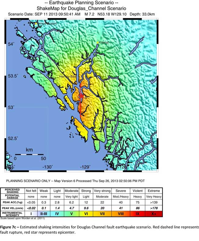
Model #2. A magnitude 7.2 Earthquake in Douglas Channel
The Geological Survey Canada model for a 7/2 magnitude earthquake in the lower Douglas Channel. The possible damage is colour coded in the table below the map according to the Modified Mercalli Intensity Scale. The red star represents the possible epicentre. (Geological Survey of Canada)
The second model looked at an earthquake in Douglas Channel based on the “fault like structure” if a slip strike rupture occurred along the entire 60 kilometers of the so far unconfirmed fault, resulting in a 7.2 magnitude earthquake. There would be very strong shaking within 20 kilometers radius of the epicentre, with moderate to heavy damage” in the relatively uninhabited islands, major shaking in Hartley Bay, resulting in very strong to strong damage at Hartley Bay and strong to moderate damage in Kitimat.
That earthquake, however, would be felt across the entire province of British Columbia. The report notes:
The expected effects and impacts of such an earthquake would mimic those of the 1946 magnitude 7.3 Vancouver Island earthquake, which occurred slightly west of Courtney and Campbell River. Shaking due to the 1946 earthquake was felt as far as Prince Rupert, BC to the north and Portland, Oregon to the south. In addition to knocking down 75 per cent of the chimneys in the local area, much of the earthquake-related damage was due to landslides, slumping and liquefaction
Model #3 A magnitude 6.3 Earthquake near Terrace
The Geological Survey Canada model for an 6.3 magnitude earthquake southwest of Terrace. The possible damage is colour coded in the table below the map according to the Modified Mercalli Intensity Scale. The red polygon represents the area of possible rupture in the model with the star representing the epicentre. (Geological Survey of Canada)
On May 11, 1973, a magnitude 4.7 shallow earthquake took place about 20 kilometers south west of Terrace, on the south side of the Skeena roughly across from the Shames mountain area. The earthquake was felt up to 120 kilometers away. The report says “The event has not been associated with any geologic features in the area and little is known about its rupture process.” The model estimated the results of a larger earthquake 6.3 magnitude in the same area. The model showed there would be strong to very strong shaking in Terrace, light to moderate shaking in Kitimat and light damage elsewhere in the BC North Coast. Most of the damage would be concentrated in a 20 kilometer zone around the epicentre.
The cause of the two failures is still unknown but the report says “their proximity to a nearby unmapped fault-like structure suggests that the slides could have been triggered by strong ground shaking from rupture along this structure.”
Another factor was the two well-known landslides occurred in the 1970’s in the Kitimat Arm which generated tsunamis but fortunately they occurred at low tide which decreased the impact. On October 17, 1974 a submarine slide generated a 2.8 metre tsunami. The following year on April 27, 1975, a slope failure on the northeast side of Kitimat Arm (which overlapped the 1974 failure area) displaced an estimated upper limit of 26,000,000 cubic metres of material.
“Watermark observations in Kitamaat Village estimated that the tsunami generated by this slide was up to 8.2 metres high.” The report says that while the trigger of the first event is unknown; the latter event coincided with nearby construction at that time. Modelling of the 1975 slide estimates that given the right conditions the generated tsunami waves could have been as high as 11 metres.
The report also notes that numerous landslides have also been mapped by the BC Department of Forestry in an attempt to improve safety measures for forestry workers.
The report says “The culmination of these studies brings awareness to the significant natural hazards present in the fragile coastal environment of the Coast Ranges.”
Another factor is the geology of the BC coast. The granitic mountains have rugged, steep slopes dissected by an intricate fjord system and dotted with islands of lower elevation. At lower elevations the land is covered by wet, coastal hemlock forests, which could be vulnerable to ground failures whereas higher elevations are characterized by barren rock or mountain hemlock subalpine.
Table of Seismic monitoring and GPS stations in northern BC from the Geological Survey of Canada (Geological Survey of Canada)
The District of Kitimat said it has “not directly studied these issues but we are aware of potential hazards.” The development department has been advised of potential issues and site concerns.
A spokesperson for Terrace mayor Carol Leclerc told Northwest Coast Energy News in an e-mail. “I have reviewed it and distributed it to the relevant department heads. We are aware that historically Terrace has been at risk for experiencing seismic activity due to its location.”
The District of Kitimat did cooperate with National Resources in finding a location for their recently installed seismic equipment.
At Harley Bay, Gitga’at First Nation CEO Ellen Torng said the Gitga’at have been “ working with NRCan on their research in the Douglas Channel and in Hawksbury. NRC has been meeting with First Nations along the coast and have conducted community sessions on their research.
“We hosted one community session here in Hartley Bay and have regular updates from their technical team when they are in the area,” Torng said.
In addition, the District of Kitimat told Northwest Coast Energy News that Community Planning & Development department also provided local land information to geoscientists in the years leading up an international study called Batholiths on land in 2009.
Batholiths are large zones of molten rock that have solidified in the earth’s crust and are believed to play a key role in the formation and growth of continents. The Coast Mountain Range has a large concentration of batholiths, which means Kitimat was an excellent place to study the earth’s crust.
The project, which involved more than 50 scientists from nine Canadian and American universities, was set up to examine how mountain belts form and change over time and why continental mountain ranges are made of granite not basalt. Seismic imaging of the crust and mantle below the mountains required deploying thousands of seismic sensors and recorders, and recorded responses to several man-made detonations. Field work was completed in July 2009, and several scientific papers and dissertations have followed.
The Heiltsuk Nation was unable to respond to a request for comment due to the ongoing crisis from the sinking of the tug Nathan E. Stewart and the resulting spill of diesel fuel and other contaminants near Bella Bella.
Not felt except by a very few under especially favorable conditions.
II
Weak
Felt only by a few persons at rest,especially on upper floors of buildings.
III
Weak
Felt quite noticeably by persons indoors, especially on upper floors of buildings. Many people do not recognize it as an earthquake. Standing motor cars may rock slightly. Vibrations similar to the passing of a truck. Duration estimated.
IV
Light
Felt indoors by many, outdoors by few during the day. At night, some awakened. Dishes, windows, doors disturbed; walls make cracking sound. Sensation like heavy truck striking building. Standing motor cars rocked noticeably.
V
Moderate
Felt by nearly everyone; many awakened. Some dishes, windows broken. Unstable objects overturned. Pendulum clocks may stop.
VI
Strong
Felt by all, many frightened. Some heavy furniture moved; a few instances of fallen plaster. Damage slight.
VII
Very strong
Damage negligible in buildings of good design and construction; slight to moderate in well-built ordinary structures; considerable damage in poorly built or badly designed structures; some chimneys broken.
VIII
Severe
Damage slight in specially designed structures; considerable damage in ordinary substantial buildings with partial collapse. Damage great in poorly built structures. Fall of chimneys, factory stacks, columns, monuments, walls. Heavy furniture overturned.
IX
Violent
Damage considerable in specially designed structures; well-designed frame structures thrown out of plumb. Damage great in substantial buildings, with partial collapse. Buildings shifted off foundations.
X
Extreme
Some well-built wooden structures destroyed; most masonry and frame structures destroyed with foundations. Rails bent.
In a two to one decision, the Federal Court of Appeal has overturned the Harper government’s approval of the Enbridge Northern Gateway Pipeline, finding that the federal government’s consultation process with First Nations on the BC coast that occurred after the NEB decision and the Joint Review Panel Report was inadequate, saying:
We conclude that Canada offered only a brief, hurried and inadequate opportunity in Phase IV—a critical part of Canada’s consultation framework—to exchange and discuss information and to dialogue. The inadequacies—more than just a handful and more than mere imperfections—left entire subjects of central interest to the affected First Nations, sometimes subjects affecting their subsistence and well-being, entirely ignored.
The dissenting judge found that the federal government under Stephen Harper had adequately consulted the First Nations. The split decision means that one of the parties, either the federal government, Enbridge Northern Gateway or the Canadian Association of Petroleum Producers may seek leave to appeal to the Supreme Court of Canada.
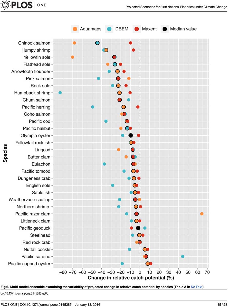
That’s one of the predictions from a new study from the University of British Columbia, looking at the future of the fishery on the coast.
The study concentrates on the First Nations fishery and warns that aboriginal people could face a catastrophic decline in the harvest of traditional species, especially salmon and herring roe on kelp over the next thirty years, a decline that will also have an equally devastating effect on commercial and recreational fishing.
The main cause of the decline is climate change and the warming of the coastal waters. The study projected “modest to severe declines in catch potential” for all current commercial fisheries along the coast.
The study says that for the First Nations the between $28 million to $36 million in revenue they got from fishing between 2001 and 2010 could fall by up to 90 per cent depending on how the climate changes.
A chart from the UBC study shows possible decline in fish species under different climate scenarios. (PLOS1)
One scenario calls for a decline of up to 40 per cent in chinook and pink salmon.
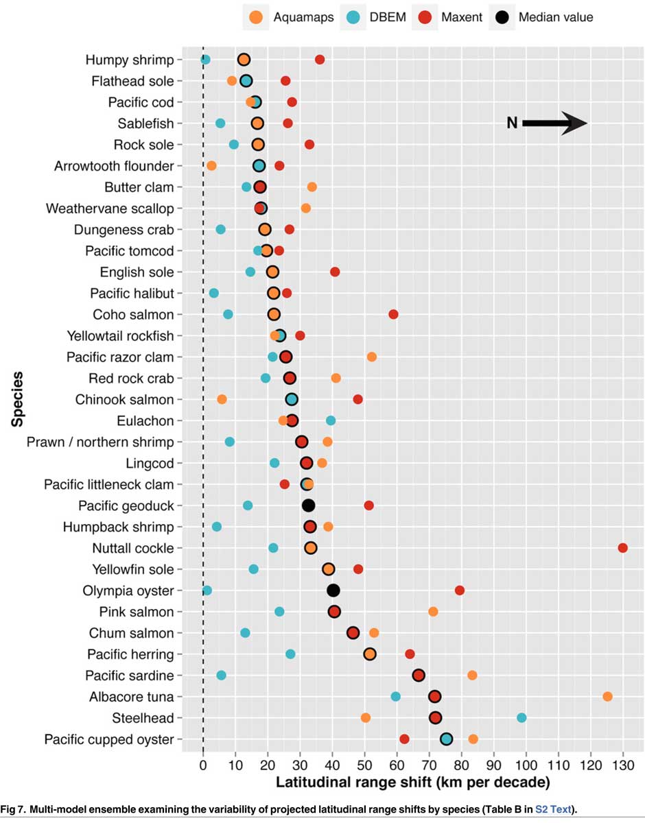
If there is any good news, if you can call it that, the decline will be not as bad in northern coastal waters as it will be the warmer waters near the Lower Mainland and southern Vancouver Island. The range of some species, including salmon, herring, halibut and possibly oolichan will move to farther north along the BC Coast and into Alaskan waters.
That means in time the warming waters will also encourage an increase in other species, including sardines and some clams.
The changing oceans mean that “an increase in the relative abundance of warmer-water species was projected to lead to new or increased opportunities for commercial harvests by 2050.”
The study is urging the First Nations and other stakeholders in the British Columbia fishery to start long term planning immediately to anticipate changes in the coming decades.
The team of scientists led by Lauren Weatherdon, a graduate student at UBC, noted that while previous studies have looked at the impact of climate change on large-scale commercial fisheries, “few efforts have been made to quantitatively project impacts on small-scale subsistence and commercial fisheries that are economically, socially and culturally important to many coastal communities.”
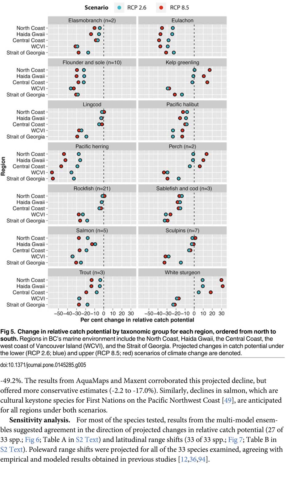
The study was conducted in cooperation with the BC First Nations Fisheries Council and looked its seven coastal administrative regions “forming a sample of groups with diverse marine resources, geographical locations, territorial sizes, and treaty statuses.”
Within those regions 16 First Nations participated in the study, some under their treaty councils, including the Council of the Haida Nation, the Tsimshian Nations Treaty Society (including the Gitga’at at Hartley Bay and the Kitselas and Kitsumkalum near Terrace) and the Maa-nulth First Nations. The Heiltsuk First Nation at Bella Bella participated as an independent group.
The FNFC’s administrative regions intersect with five distinct ecological regions: the North Coast, comprising the Hecate Strait and Dixon Entrance; Haida Gwaii, which includes the waters surrounding the islands; the Central Coast, including Queen Charlotte Sound, Queen Charlotte Strait, and the southern tip of Hecate Strait; the Strait of Georgia; and the west coast of Vancouver Island (WCVI) .
The study says First Nations are likely to be exposed to different climate-related impacts on fisheries due to the differing ecological and biogeographical characteristics of these regions and to differing traditional and commercial harvests.
The study used a “dynamic bioclimate envelope” computer model to look at the changes to the distribution and relative abundances of the BC coastal species under two climate change scenarios, a high greenhouse gas model where society can’t curb emissions and a low greenhouse gas emission scenarios, depending on how society is able to curb the increase.
The study looked at ocean properties—including sea surface temperature, sea bottom temperature, salinity, oxygen concentration, surface action, and net primary production—using data from the US National Ocean and Atmospheric Administrations’ climate-related earth system model.
Climate change will mean that current species on the BC coast will “shift polewards.”
The study showed that by 2050, there could be declines in 87 of the 98 species in the study.
Greater losses in what the study calls “species richness” is likely to occur towards the southern coast of British Columbia, falling primarily between 48°N and 51°N. But, overall, species richness along coastal BC will continue—only with different species.
Most significantly the study projects a decline in the overall salmon catch from 17.1 per cent to 29.2 per cent, depending on the region and climate.
All aspects of the herring fishery, including roe herring, spawn-on-kelp, and the food and bait fishery could decline between 28.1 per cent and 49.2 per cent depending on the region.
The future of the oolichan is the most uncertain. One of the models studied projected a further 37.1 per cent decline in the oolichan, while other models called for for a decline between 5 per cent and 6.8 per cent. That will depend on how well, the oolichan already threatened in most regions of British Columbia are able to adapt to warmer waters or find a way to move their range northward.
The study says white sturgeon and Pacific sardines were projected to increase in abundance under both climate change scenarios, while manila clams were projected to increase in abundance by 14.5 per cent in one of the models. The eight remaining species showed little change.
The study suggests that the southern territories (Tsawwassen, Tla’amin, and Maa-nulth First Nations) will likely see a reduction in catch potential between -15.2 per cent and -27.8 per cent depending on how the climate changes.
On the north coast. The Haida and Tsimshian First Nations and those situated along the central or north-eastern coasts of Vancouver Island (Heiltsuk and ‘Namgis First Nations) would likely see smaller reductions in relative catch for each territory, with estimates falling between -3.2 per cent and -8.2 per cent.
The study shows that for the First Nations along the North and Central Coasts of British Columbia (Gitga’at and Haida, and Heiltsuk and ‘Namgis) there will be neutral or positive shifts in catch potential for white sturgeon, kelp greenling, and two species of perch under both scenarios.
While varying regionally, both scenarios also suggested either a slight cumulative decline or negligible change in catch potential for clams, rockfish, lingcod, and sculpins across the North and Central Coast.
One potential problem the study suggests is that fishers in southern British Columbia may, in the future, try to move north to follow the harvest, leading to potential conflicts. The cost of travel, may, however, discourage that.
One of the recommendations from the study is that First Nations revive the traditional clam gardens.
Traditional clam beds serve as an ideal example of a method that could be applied to offset climatic impacts through internalized mechanisms, using local cultivation to generate increased productivity by enhancing native habitat rather than redirecting extraction efforts towards other regions or species. Clam gardens constructed in a manner akin to those situated near ancient settlements of the Northern Coast Salish and Laich-kwil-tach First Nations have been found to generate higher clam densities, biomass, and growth rates than non-walled beaches . These benefits were observed for Pacific littleneck clams and butter clams , two clams that are of cultural, economic, and ecological importance to the region Reinstating clam beds in First Nations’ territorial lands has been suggested as a means of simultaneously achieving local conservation and cultural objectives and may thereby provide a politically and ecologically viable option for mitigating climate-related impacts.
The most important recommendation is that the First Nations and other stakeholders start cooperating immediately to offset how the changing climate with affect the fishery:
Management of salmon and herring stocks has been highly contentious due to the myriad of stakeholders who depend upon them, which include First Nations, recreational fisheries, and commercial fisheries….
Aside from fulfilling societal needs, salmon serve as key ecological components of the Pacific Northwest Coast, functioning as the mechanisms by which nutrients are transferred from the ocean to freshwater and terrestrial ecosystems
It says the projections show that a “redistribution of fishing effort” will not “fully offset declines in salmon and herring”
attaining a state of collaboration between First Nations, DFO, and other sectors has the potential to yield beneficial ecological and political results, if implemented correctly. Parallels exist between First Nations’ traditional fisheries management approaches and “modern” approaches (e.g., spatial management, mariculture, selective fishing, fishing closures), with differences arising primarily due to diverging worldviews.
It recommends local application of First Nations’ traditional management strategies to “provide opportunities to collaboratively engage in adaptive ecosystem-based management and to coordinate efforts to attain conservation objectives.”
They give an example of how the Nisga’a Nation have ensured their equal partnership in management by employing traditional fish wheel technology to monitor and assess stocks and by leveraging traditional ecosystem-based management practices that could be applied to plan long-term objectives and management approaches.
It concludes by saying that joint-management will not only work to reduce the impact of climate change but also head off potential conflict.
Through such joint-management regimes, traditional fisheries management strategies could be applied to advance localized research directives and to reduce impacts on stocks under unprecedented environmental change. Moreover, the risk of conflict over declining resources underlines the need to establish common and equitable ground to ensure successful joint management of fisheries, and to leverage collective expertise.
Chart from the study showing which fish species will move north up the coast as the climate changes. (PLOS1)
The response to the Joint Review Panel decision on the Northern Gateway, beginning in December and continuing until this Canada Day, both in the public and in the media is sharply divided by the Rocky Mountains.
A lof of Albertans, most of the energy companies and many in the media, especially the Toronto-based business press, keep telling Canadians that the NEB is an independent, quasi-judicial body, that carefully weighs the scientific and other evidence before coming to a conclusion.
Prime Minister Stephen Harper stands up in Question Period and from his prepared script also claims the JRP and NEB are independent bodies.
Most of those writing about the attitude of the National Energy Board have never attended a single hearing, As for the Joint Review,. those from the major media who did attend were only there for the opening and closing sessions.
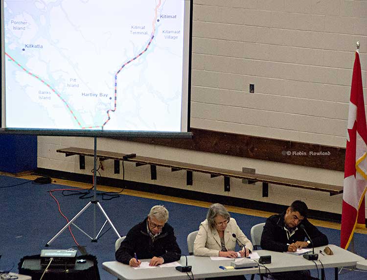
Members of the Northern Gateway Joint Review Panel, left to right, Kenneth Bateman, chair Sheila Leggett and Hans Matthews make notes at the June 25, 2012 hearings at the Haisla Recreation Centre, Kitamaat Village. A map of Douglas Channel can be seen behind the panel. (Robin Rowland/Northwest Coast Energy News)
In British Columbia, those attended the Northern Gateway Joint Review sessions saw a strange and arcane bureaucratic system with rules of evidence and procedure often tilted toward a proponent in the energy sector.
Those rules of evidence were created for the cosy club atmosphere of the NEB in Calgary where mostly there are friendly hearings attended only by the proponents and energy sector lawyers. Those same rules were infuriating to those in northwest British Columbia trying and failing to persuade the JRP to take seriously many of the concerns of the region. The rules of evidence and procedure were baffling to lawyers practicing in BC; even the highly experienced lawyers from the BC Department of Justice were chewed out by the JRP in Prince George for not following proper procedures.
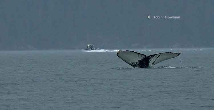
The tail fins of a humpback whale are seen in Douglas Channel near Bish Cove, as a fishing boat speeds toward Kitimat harbour in a rain storm on Aug. 21, 2013. (Robin Rowland/Northwest Coast Energy News)
The JRP seemed to believe that time stopped at the evidentiary deadline, and although it acknowledged that Northern Gateway was a 50 year project, the panel didn’t need to know anything new.
A careful reading of the two volumes of the Joint Review Panel report and decision clearly shows that JRP finding was not, as one columnist called it, a triumph of science over emotion, but a proceeding that was biased from the outset to find in favour of Enbridge. It is clear that even though the Joint Review Panel did impose 209 conditions on Northern Gateway, reading those almost 500 pages one sees time and time again that Northern Gateway’s evidence and assurances were accepted at face value, while the panel treated the evidence and testimony from opponents with a much higher level of skepticism.
Moving to Calgary
One of my sources once told me that the “NEB is nothing more than an extension of the Petroleum Club.” In the 1991 budget, then Prime Minister Brian Mulroney moved the NEB headquarters from Ottawa to Calgary as a political gift to Alberta.
At that time the move was also seen as practical, Alberta was still complaining no one in Ottawa was listening to it. So if the Conservative government moved the NEB to Calgary, it would be there listening to the oil patch. NEB offices were scattered across the country, consolidating them in Calgary seemed, at the time, to be a way of saving taxpayers’ money and enhancing internal communications.
Seen now, about 25 years later, it’s clear the NEB move from its Ottawa headquarters and regional offices to Calgary was a disaster waiting to happen. Over the past quarter century, despite its claims of independence, the NEB and its staff have become so embedded in the oil patch energy culture of Calgary that (probably subconsciously) the NEB has shown that it is largely incapable of really taking seriously the culture of British Columbia on issues such as the Northern Gateway and Kinder Morgan projects. The NEB Calgary culture is also colliding,with the concerns and culture of other parts of the country as diluted bitumen pipelines head eastward.
The Conservative omnibus bills that gutted environmental protection and speed up the review process has made things much worse–at least until this week.
Now the Supreme Court has sent a shot across the bow of the full steam ahead National Energy Board, compelling the board to put much more weight on the concerns of First Nations.
The decision upholding the Tsilhqot’in claim to its traditional territory means the NEB and any future joint review panel (whether involving multiple federal agencies or federal agencies and a province) are going to have to take the concerns of First Nations and indeed all Canadians a lot more seriously—and the future of the planet as well, as described in the first part of this analysis. Chief Justice Beverly McLaughlin wrote that on First Nations` traditional territory:
that it is collective title held not only for the present generation but for all succeeding generations. This means it cannot be alienated except to the Crown or encumbered in ways that would prevent future generations of the group from using and enjoying it.
“Future generations” is the key phrase.
Future generations could undermine that whole world view of the Joint Review Panel, since the panel so casually dismissed the fears of a major disaster on the coast, saying it was “unlikely” and could be “mitigated.”
The JRP basically had a so-what attitude to British Columbia, arguing that since parts of the British Columbia environment had already been degraded any future environmental problems would be minimal and could be “mitigated.”
Public interest
While in the introduction to its definition of the Public Interest, the JRP says
If approved and built, the Enbridge Northern Gateway Project could operate for 50 years or more. Sustainable development was an important factor in our environmental assessment and our consideration of the public interest. The project would have to meet today’s needs without compromising the ability of future generations.
Sounds like that might match the Chief Justice. But, as the old saying goes, the devil is in the details. And just a few paragraphs later, the JRP says:
Our assessment of the project’s effects on residents and communities Considering Northern Gateway’s project design, its commitments, and our conditions, we concluded that the project’s potential effects on people’s land, water, and resource use could be mitigated. We were not persuaded that construction and routine operations of the project would have a negative effect on the social fabric of communities in the project area. We also were not persuaded that the project would adversely affect the health and well being of people and communities along the route or in coastal areas. We found that the net overall economic effects of the project would be positive and would provide potential benefits and opportunities to those individuals and businesses that choose to participate in the project.
“Trust Enbridge”
The JRP’s attitude toward a major disaster was “trust Enbridge.”
We found that some level of risk is inherent in the Enbridge Northern Gateway project, and that no party could guarantee that a large spill would not occur. We found that a large spill, due to a malfunction or accident, from the pipeline facilities, terminal, or tankers, is not likely.
We found that Northern Gateway has taken steps to minimize the likelihood of a large spill through its precautionary design approach and its commitments to use innovative and redundant safety systems, such as its commitments to address human error, equipment failures, and its corporate safety culture. These commitments and all others made by the company
Oh well, the ecosystem will recover eventually—a conclusion that could be reached only by ignoring the evidence from Prince William Sound, site of the Exxon Valdez spill.
We found that, in the unlikely event of a large oil spill, there will be significant adverse environmental effects, and that functioning ecosystems recover through mitigation and natural processes.
We found that a large oil spill would not cause permanent, widespread damage to the environment. The extent of the significant adverse effects would depend on the circumstances associated with the spill. Scientific research from past spill events indicates that the environment recovers to a state that supports functioning ecosystems similar to those existing before the spill. We found that, in the unlikely event of a large oil spill, there would be significant adverse effects on lands, waters, or resources used by residents, communities, and Aboriginal groups.
We found that, in rare circumstances, a localized population or species could potentially be permanently affected by an oil spill. Scientific research from a past spill event indicates that this will not impact the recovery of functioning ecosystems.
In other words, some communities, probably aboriginal communities, would have be sacrificed in the public interest and the economics of Alberta while the economy of that part of British Columbia would be destroyed.
Will the JRP have to start over?
The environmental law community and First Nations leaders are already taking a look at another paragraph in the Supreme Court judgement. Paragraph 92 in lawyer speak.
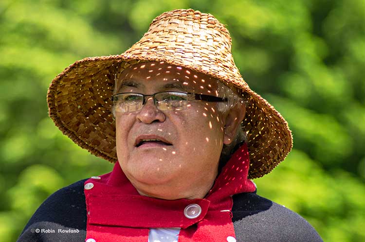
At the celebration of the Supreme Court decision, on June 26, Gerald Amos welcomed the suggestion from lawyers that the ruling could force a re-examination of Northern Gateway. (Robin Rowland/Northwest Coast Energy News)
One of the many reports comes from West Coast Environmental Law which noted in an e-mail
[T]he Tsilhqot’in decision, Canada’s highest court brings home the implications of this for Enbridge and other project proponents:
Once title is established, it may be necessary for the Crown to reassess prior conduct in light of the new reality in order to faithfully discharge its fiduciary duty to the title-holding group going forward.
For example, if the Crown begins a project without consent prior to Aboriginal title being established, it may be required to cancel the project upon establishment of the title if continuation of the project would be unjustifiably infringing.
And what about the overhaul of environmental legislation in 2012 to smooth the way for pipeline and other industrial development?
The court notes: “Similarly, if legislation was validly enacted before title was established, such legislation may be rendered inapplicable going forward to the extent that it unjustifiably infringes Aboriginal title.”
Reset
In other words, the Supreme Court decision resets everything.
It could nullify the recent decision by the Prime Minister to permit the Northern Gateway to go ahead. Or it could mean, especially given the number of court challenges just to the JRP, that, in light of the Tsilhqot’in decision the panel will be ordered by a court to go back to the drawing board and reconsider its findings.
Then there are the pending challenges to the Harper decision allowing the Northern Gateway to go ahead. Sources told Northwest Coast Energy News that the first of a number of court challenges were to be filed last week. It is likely that after the holiday weekend, lawyers will be rewriting their filings and their briefs in light of the Tsilhqot’in decision and presenting the Federal Court with those challenges some time in July.
The justices of the Supreme Court did allow a public interest exemption on the use of First Nations land for a larger purpose, but there must now be genuine consultation and the public interest will likely have be proven beyond a reasonable doubt, it can’t just be the whim of a prime minister with a tame, unquestioning caucus who decides what is in the public interest.
Who consults whom?
In the decision, Chief Justice McLaughlin wrote:
Governments and individuals proposing to use or exploit land, whether before or after a declaration of Aboriginal title, can avoid a charge of infringement or failure to adequately consult by obtaining the consent of the interested Aboriginal group
and later
The right to control the land conferred by Aboriginal title means that governments and others seeking to use the land must obtain the consent of the Aboriginal title holders. If the Aboriginal group does not consent to the use, the government’s only recourse is to establish that the proposed incursion on the land is justified under s. 35 of the Constitution Act, 1982.
Compare that again with what the JRP said. As with the environmental impact it begins by saying:
The Panel finds that the magnitude, extent, and potential impacts of this project required an extensive program of public consultation. The Panel considers thorough and effective consultation to be a process that is inclusive of, and responsive to, all potentially-affected groups and individuals.
Then the JRP says:
The Panel notes that, among potentially-affected parties, there were differing perspectives on what constitutes a thorough and effective process of consultation. There were also different views among some parties about how consultation should occur, and their roles and responsibilities during consultation.
And then:
The Panel believes that it is critical for all parties to recognize and understand their respective roles and responsibilities for achieving effective dialogue during consultation. The Panel noted the principles of thorough and effective consultation at the beginning of this chapter. The Panel finds that these principles require that a process must provide timely, appropriate, and effective opportunities for all potentially-affected parties to learn about a project, provide their comments and concerns, and to discuss how these can be addressed by the applicant.
So what does it mean?
The JRP starts off by giving Northern Gateway a slap on the wrist:
The applicant [Enbridge] must be genuinely responsive. Affected parties have an ongoing and mutual responsibility to respond to opportunities for consultation, to communicate concerns they may have, and to discuss how these can be addressed.
But then it goes on in the same paragraph:
Consultation requires trust, mutual respect, and relationship-building. All parties have an obligation to seek a level of cultural fluency, in order to better understand the values, customs, needs, and preferences of the other parties involved in the consultation process. All parties may be required to adjust their expectations in response to the information, concerns, and interests raised and considered through the process. The Panel observed that this approach did not always occur in this proceeding.
Get the phrase “all parties.” It is clear here that the JRP is taking on the First Nations and other opponents for not seeing Northern Gateway’s point of view, since it accepts, as seen below, Northern Gateway’s contention that it is doing a good job with consultation,
And the word “trust.” Again the Alberta-bound JRP (the panel had no members from British Columbia, two from Alberta, one from Ontario) are saying “trust Enbridge.”
Unfortunately after a decade of operating in the northwest, and despite its spin, Enbridge has failed time and time again to establish trust with First Nations and it has equally failed to establish trust with a significant number non-aboriginal residents of the northwest.
The companies developing LNG projects have, for the most part, established a level of trust.
The joke up here is now so old it’s a cliche (but still unknown to the eastern media) where an LNG executive says, “We look at what Enbridge did and do the exact opposite.”
The Panel accepts Northern Gateway’s view that consultation is a process which should ensure that all parties are better informed through consultation, and that it involves being prepared to amend proposals in light of information received. In this regard, the Panel notes that Northern Gateway made numerous changes to the design and operation of the project in response to input provided by the public, landowners, governments, and stakeholders
In fact, Northern Gateway is still fumbling the ball.
It is true that Northern Gateway did change its plans and put another $500 million into the plans for the project–after a lot of public pressure and growing controversy during the JRP hearings over its plans.
JRP Chair Sheila Legget during the final arguments in Terrace, June 17, 2013. (Robin Rowland/Northwest Coast Energy News)
Equally telling was Northern Gateway’s dismissal in its final arguments (arguments accepted by the JRP) that there was no earthquake hazard in the region, despite two major earthquakes at Haida Gwaii and southern Alaska just months earlier, both of which shook Kitimat.
In the final oral arguments, Northern Gateway’s lawyer Richard Neufeld summarily dismissed the fears of the Haida and Heiltskuk First Nations about destruction of the herring spawning beds because, he said, first, the chances of a tanker disaster were unlikely and second, even if there was a tanker disaster it was even more unlikely that it would occur during the spawning season. (Not that the spawning season matters, herring beds in San Francisco Bay are still damaged years after a spill there).
Now with the Tsilhqot’in decision, Enbridge can no longer summarily dismiss those fears. The companies who have proposed liquefied natural gas projects are meeting with anyone, including avowed opponents, and opening dialogues, even if both sides continue to disagree. Despite its spin, accepted by the political pundits and eastern business media, those who live in the northwest know Northern Gateway’s consultations and engagement, so far, have mostly been with friendly groups and friendly audiences.
The Supreme Court decision is going to change that attitude in the coming weeks. If Enbridge wants Northern Gateway to go ahead, the company is going to have to genuinely engage with First Nations. Given all the damage created by Enbridge over the past decade, that engagement is unlikely to change anything.
The Supreme Court decision is going to have one more consequence.
Eventually, in a few years, the decision will negate that stupid attitude from the conservative media and some in the business community that the people of northwestern British Columbia are against all development. That was never true but it’s a convenient excuse for those columnists and conservatives not to question their own assumptions.
If the reporters and columnists had bothered to come up here, if the press-release dispatching business leaders had bothered to leave their executive suites, they’d know what northwestern BC wants is responsible and sustainable development, not quick in and out profits.
The Supreme Court decision means that any future industrial development in the northwest will be much different from anything seen in the past because First Nations must be involved from the beginning.
Given its sorry track record, it is unlikely that Enbridge will be part of that development. but others will profit, yes profit, from that failure.
In the coming years it is also likely that there will be a new approach to development from the National Energy Board after they begin to see their narrow oil-patch friendly approach and rulings struck down by the courts quoting the Tsilhqot’in decision.
Zone maps for the North Coast marine draft plan. (MAPP)
District of Kitimat Council has urged residents to turn out in large numbers for consideration of the North Coast Draft Marine Plan at the Kitimat Valley Institute Tuesday, May 13, from 5:30 to 8:30.
In introducing the motion, Mayor Joanne Monaghan said she was worried that not enough Kitimatians, especially charter operators, boaters and fishers were aware of the meeting.
Another council member privately said he was worried that the Open House and Forum weren’t publicized enough so that the town could be checked off as having “been consulted.”
MAPP stands for Marine Planning Partnership for the North Pacific Ocean.
According to the documents the purpose of the North Coast Marine Plan “is to provide recommendations for achieving a sustainable balance between ecosystem health, social and cultural well-‐being and economic development through an ecosystem-‐based approach to planning and management.”
The plan is all about managing “common First Nation and provincial interests related to marine areas.”
The parners include the province and the Skeena First Nations Stewardship Society (NCSFNSS), representing the Metlakatla, Kitsumkalum, Kitselas, Haisla, Gitga’at, and Gitxaala Nations.
According to the doucments the North Coast plan area covers 27,000 kilometres of coastline;
that is indented with deep fjords and dotted with thousands of islands. It is a region of profound beauty, significant ecological diversity and remarkable cultural richness. Prince Rupert, Terrace and Kitimat are the largest communities in the North Coast plan area, which supports an overall population of approximately 42,000.
According to the summary of the plan:
The physical complexity of the North Coast includes a range of ecosystem types, including important estuaries that support distinct marine ecosystems and species. A diverse range of economic and community activities occur within the North Coast plan area. Commercial fisheries and associated processing facilities and logging have supported communities along the coast since the early 1900s. These activities continue to be important to the well-‐being of coastal communities. Port activities centered around the communities of Prince Rupert, Kitimat and Stewart, and active recreational fishing and tourism sectors, continue to be strong economic drivers in the area. North Coast First Nations living in the region have distinct cultural and spiritual heritages that are intricately linked to the marine environment and the long-‐standing sustainable use and management of marine resources.
The plan appears to overlap some areas where there have been environmental assessments of the Northern Gateway and the numerous liquified natural gas proposals.
The plan summary goes on to say:
The draft plan brings together science and Aboriginal knowledge, input from the technical staff of NCSFNSS (representing the Gitga’at, Gitxaała, Metlakatla, Kitsumkalum, Kitselas and Haisla Nations) and the Province. Key information and direction was provided by First Nations strategic marine use plans and existing provincial planning and policy documents.
Ecological, cultural and social and economic data sources were compiled and analysed by the joint technical team and contract support. Relevant background scientific reports and technical documents from the Pacific North Coast Integrated Management Area (PNCIMA) process were also used, along with the BC Marine Conservation Analysis. Additional information was drawn from government reports and publications, academic literature, industry or sector publications, discussions with experts and local knowledge. Advice was also incorporated from the North Coast Marine Plan Advisory Committee and public and stakeholder engagement.
The Pacific North Coast Integrated Management Area process was killed by the Harper government in the fall of 2011 . The decision to kill the PNCIMA was officially for budget reasons, but general speculation at the time was that Harper and then Natural Resources Minister Joe Oliver wanted to kill PNCIMA as one way of ensuring the government could push through the Northern Gateway project. The MAPP program was set up by the province and First Nations as a reaction to Harper’s decision.
Excerpts from the Northern Gateway Joint Review Panel report relating to the Exxon Valdez disaster.
Northern Gateway told the Joint Reivew Panel that
on a worldwide basis, all data sets show a steady reduction in the number
and size of oil spills since the 1970s. This decline has been even more apparent since regulatory changes in 1990 following the Exxon Valdez oil spill, which required a phase-in of double-hulled tankers in the international fleet. No double-hulled tanker has sunk since 1990. There have been five incidents of double-hulled tankers that have had a collision or grounding that penetrated the cargo tanks. Resulting spills ranged from 700 to 2500 tonnes
The Haisla countered by saying:
The Haisla Nation said that, although there have been no major spills since the Exxon Valdez spill in Prince William Sound, there were 111 reported incidents involving tanker traffic in Prince William Sound between 1997 and 2007. The three most common types of incidents were equipment malfunctions, problems with propulsion, steering, or engine function, and very small spills from tankers at berth at the marine terminal. The Haisla Nation said that, in the absence of state-of-the-art
prevention systems in Prince William Sound, any one of those incidents could have resulted in major vessel casualties or oil spills.
There were disputes about how the Exxon Valdez affected species in the Prince William Sound area:
Northern Gateway said that, although crabs are known to be sensitive to toxic effects, they have been shown to recover within 1 to 2 years following
a spill such as the Exxon Valdez incident. Northern Gateway said that Dungeness crab was a key indicator species in its assessment of spill effects.
Northern Gateway said that potential effects to razor clams are not as well studied. It said that sediment toxicity studies after the Exxon Valdez spill did not suggest significant effects on benthic invertebrates. Following the Exxon Valdez and
Selendang Ayu oil spills in Alaska, food safety closures for species such as mussels, urchins, and crabs were lifted within 1 to 2 years following the
spill.
In response to questioning from the Council of the Haida Nation regarding potential spill effects on herring, Northern Gateway said that herring were a key indicator species in its spill assessment.
Northern Gateway said that the Exxon Valdez spill did not appear to cause population-level effects on Prince William Sound herring.
As did throughout its report, the Joint Review Panel gave great weight to Northern Gateway’s evidence:
Northern Gateway said that potential effects of oil stranded on the shorelines and in the intertidal environment were assessed qualitatively with particular reference to the Exxon Valdez oil spill. It said that the entire intertidal zone along affected
shorelines would likely be oiled, coating rocks, rockweed, and sessile invertebrates. Some of the diluted bitumen could penetrate coarse-grained intertidal substrates, and could subsequently be remobilized by tides and waves. There were
relatively few shoreline areas with potential for long oil residency. Northern Gateway said that the stranded bitumen would not be uniformly distributed, and that heavy oiling would likely be limited to a small proportion of affected shoreline. Northern
Gateway said that, compared to the Exxon Valdez oil spill, the simulation suggested that more dilbit would be distributed along a shorter length of shoreline.
Northern Gateway said that, due to the relatively sheltered conditions in Wright Sound, and in the absence of cleanup, most of the stranded oil would be weathered or dispersed into the marine environment within 3 to 5 years. It said that,
while weathering and dispersal could represent an important secondary source of hydrocarbon contamination of offshore or subtidal sediments, the weathered hydrocarbons themselves would have lower toxicity than fresh dilbit.
Northern Gateway assessed potential effects on key marine receptors including marine water quality, subtidal sediment quality, intertidal sediment
quality, plankton, fish, and a number of bird and mammal species. The company said that acute effects from monocyclic aromatic hydrocarbons such as benzene, toluene, ethylbenzene, and xylene may briefly occur in some areas. Acute effects from polycyclic aromatic hydrocarbons were not likely due to their low water solubility.
Northern Gateway said that chronic adverse effects on the subtidal benthic community were not predicted. After a large spill, consumption advisories for pelagic, bottom-dwelling and anadromous fish, and invertebrates from open
water areas and subtidal sediments would probably be less than 1 year in duration. Northern Gateway said that consumption advisories for intertidal communities and associated invertebrates, such as mussels, could persist for 3 to 5 years or longer in
some sheltered areas.
But dilbit is different from heavy crude
In response to questions from the Haisla Nation and the United Fishermen and Allied
Workers Union, Fisheries and Oceans Canada said that, although it had a great deal of information on conventional oils, the results of research conducted on the biological effects of conventional oil products may not be true for dilbit or unconventional products. Fisheries and Oceans Canada said that it was not in a
position to quantify the magnitude and duration of impacts to marine resources
The United Fishermen and Allied Workers Union said that, because there are so many variables, each spill is a unique event, and some results will be unknowable. It said that a spill the size of the Exxon Valdez incident would affect the entire ecosystem
in the project area, and that recovery to pre-spill conditions would be unlikely to ever occur. It said that a spill the size of the Exxon Valdez oil spill would likely have similar effects in the project area because marine resources in the project area are
similar to those in Prince William Sound. It argued that the cold, sheltered, waters of the Confined Channel Assessment Area would likely experience reduced natural dispersion and biodegradation of oil, leading to heavier oiling and longer recovery
times than seen in Prince William Sound and elsewhere.
The United Fishermen and Allied Workers Union said that patches of buried oil from the Exxon Valdez oil have been found on sand and gravel beaches overlain by boulders and cobbles. It said that effects from a tanker spill associated with the
Enbridge Northern Gateway Project would likely be more severe than the Exxon Valdez oil spill due to the more persistent nature of dilbit and the lack of
natural cleaning action in the sheltered waters of the Confined Channel Assessment Area.
The Gitxaala Nation’s experts said that large historical spill events are not necessarily good indicators of what will happen in the future. They
argued that each spill has unique circumstances and there is still significant uncertainty about the effects of major spills.
The Gitxaala Nation concluded Northern Gateway had failed to adequately consider the potential consequences on ecological values of interest to the Gitxaala.
Gitga’at First Nation said that a spill of dilbit greater than 5,000 cubic metres would result in significant, adverse, long-term, lethal, and sublethal effects
to marine organisms, and that effects would be particularly long-lasting on intertidal species and habitats. It also said that effects from a tanker spill associated with the project would probably be more severe than the Exxon Valdez oil spill, due to
the more persistent nature of dilbit and the lack of natural cleaning action in the sheltered waters
The JRP told how Nothern Gateway looked at the scientific evidence:
The company used a case study approach and reviewed the scientific literature for environments similar to the project area. The review examined 48 spills, including the Exxon Valdez oil spill in 1989, and 155 valued ecosystem components from cold temperate and sub-arctic regions. Northern Gateway said that the scientific evidence is clear that, although oil spills have adverse effects on biophysical and human environments, ecosystems and their components recover with time.
Pacific herring, killer whales, and pink salmon were species that were extensively studied following the Exxon Valdez spill and were discussed by numerous participants in the Panel’s process.
As referred to by the Haisla Nation, Pacific herring are listed as “not recovering” by the Exxon Valdez Oil Spill Trustee Council. The Trustee Council said that, despite numerous studies to understand the effects of oil on herring, the causes constraining population recovery are not well understood.
Northern Gateway said that scientific evidence indicates that a combination of factors, including disease, nutrition, predation, and poor recruitment
appear to have contributed to the continued suppression of herring populations in Prince William Sound.
Northern Gateway said that 20 years of research on herring suggests that the Exxon Valdez oil spill is likely to have initially had localized effects on herring eggs and larvae, without causing effects at the population level. Northern Gateway said
that, even after 20 years, the effects of the spill on herring remain uncertain. It said that there has also been convergence amongst researchers that herring declines in the spill area cannot be connected to the spill.
Northern Gateway said that herring stocks along the entire coast of British
Columbia have been in overall decline for years and that herring were shown to recover within 1 to 2 years following the Nestucca barge spill.
A Gitxaala Nation expert noted the uncertainty in interpreting the decline of herring following the Exxon Valdez oil spill and said that the debate is not likely to ever be settled.
The Living Oceans Society said that the Exxon Valdez Oil Spill Trustee Council reported that some killer whale groups suffered long-term damage from initial exposure to the spill. Northern Gateway’s expert said the research leads him to
conclude that the actual effects on killer whales of the Exxon Valdez spill are unknowable due to numerous confounding factors. He said that the
Exxon Valdez Oil Spill Trustee Council has not definitively said that killer whale mortalities can be attributed to the spill. A Government of Canada
expert said that the weight of evidence suggests that the mortality of killer whales was most likely related to the spill.
Northern Gateway said that mass mortality of marine fish following a spill is rare. In response to questions from the Haisla Nation, Northern Gateway said that fish have the ability to metabolize potentially toxic substances such as polycyclic aromatic hydrocarbons. It said that international experience with oil spills has demonstrated that fin fishery closures tend to be very short in duration.
Northern Gateway said that food safety programs for fin fish conducted following the Exxon Valdez spill and the Selendang Ayu spill in Alaska indicated
that the finfish were not affected by the spill and that the fish were found, through food safety testing programs, to be safe to eat.
The Haisla Nation referred to the Exxon Valdez Oil Spill Trustee Council report that discussed the complexities and uncertainties in the recovery status of pink salmon. It said that, by 1999, pink salmon were listed as recovered and that the
report noted that continuing exposure of embryos to lingering oil is negligible and unlikely to limit populations.
Northern Gateway said that the longterm effect of the spill on pink salmon survival is
best demonstrated by the success of adult returns following the spill. Northern Gateway said that, in the month following the spill, when there was still
free oil throughout Prince William Sound, hundreds of millions of natural and hatchery pink salmon fry migrated through the area. It argued that these fish would arguably be at greatest risk from spill-related effects but that the adult returns 2 years later were one of the highest populations ever. Northern Gateway said that sockeye and pink salmon appear to have been unaffected by the Exxon Valdez spill
over the long term.
In response to questions from the Council of the Haida Nation and the United Fishermen and Allied Workers Union, Northern Gateway said that effects
on species such as seaweed, crabs, and clams have been shown to be relatively short-term, with these species typically recovering within 2 years or less
following a spill, depending on circumstances.
Northern Gateway said that, based on the Exxon Valdez spill, the level of hydrocarbons dissolved or suspended in the water column would be expected
to be substantially lower than those for which potential toxic effects on crabs or fish may occur.
In response to questions from BC Nature and Nature Canada, Northern Gateway said that the Exxon Valdez oil spill indicates which species of birds are most susceptible to oiling. Seabirds are generally vulnerable to oil spills because many species spend large amounts of time at sea. Diving seabirds such as murres are particularly vulnerable to oiling because they spend most of their time on the surface, where oil is found, and tend to raft together. Thus, these species often account for most of the bird mortality associated with oil spills.
More than 30,000 seabird carcasses, of which 74 per cent were murres, were recovered following the Exxon Valdez spill and it was initially estimated
that between 100,000 and 300,000 seabirds were killed. However, detailed surveys of breeding murres in 1991 indicated no overall difference from pre-spill levels confirming rapid recovery of this species.
Northern Gateway said that, although potential toxicological effects from oil spills on
birds have been well documented in laboratory studies, the ultimate measure of recovery potential is how quickly birds return to their natural abundance and reproductive performance. It said that recovery is often difficult to measure due to
significant natural variation in populations and the fact that the baseline is often disputed. It said that this can lead to misinterpretation of results depicting recovery.
At the request of Environment Canada, Northern Gateway filed two reports on the susceptibility of marine birds to oil and the acute and chronic effects of the Exxon Valdez oil spill on marine birds. Northern Gateway said that marine birds are
vulnerable to oil in several ways such as contact, direct or indirect ingestion, and loss of habitat.
It said that many marine bird populations appear to have recovered from the effects of the Exxon Valdez spill, but some species such as harlequin ducks and pigeon guillemots have not recovered, according to the Exxon Valdez Oil Spill Trustee
Council. It said these reports demonstrate that marine birds are susceptible to marine oil spills to varying degrees depending on the species, its life
history and habitat, and circumstances associated with the spill.
Northern Gateway concluded that:
• Marine, freshwater, and terrestrial environments recover from oil spills, with recovery time influenced by the environment, the valued ecosystem components of interest, and other factors such as spill volume and characteristics
of the oil. Depending on the species and circumstances, recovery can be quite rapid or it can range from 2 to 20 years. Other scientific reviews have indicated that recovery of marine environments from oil spills takes 2 to 10 years.
• Different marine ecosystem components recover at different rates. Recovery time can range from days or weeks in the case of water quality, to years or decades for sheltered, soft sediment marshes. Headlands and exposed rocky shores can take 1 to 4 years to recover.
• Little to no oil remained on the shoreline after 3 years for the vast majority of shoreline oiled following the Exxon Valdez spill,
• The Exxon Valdez Oil Spill Trustee Council concluded that, after 20 years, any remaining Exxon Valdez oil in subtidal sediment is no longer a concern, and that subtidal communities are very likely to have recovered.
• Because sheltered habitats have long recovery times, modern spill response gives high priority to preventing oil from entering marshes and other protected shoreline areas.
• Valued ecosystem components with short life spans can recover relatively rapidly, within days to a few years. Recovery is faster when there is an abundant supply of propagules close to the affected area. For example, drifting larvae from
un-oiled marine and freshwater habitats will rapidly repopulate nearby areas affected by a spill.
• Plankton recovery is typically very rapid.
• Seabed organisms such as filter feeders may be subject to acute effects for several years, depending on location, environmental conditions, and degree of oiling.
• Marine fisheries and other human harvesting activities appear to recover within about 2 to 5 years if the resource has recovered and has not been affected by factors other than the oil spill.
• Protracted litigation may delay resumption of fisheries and other harvesting.
• Local community involvement in spill response priorities and mitigation plans can reduce community impacts and speed recovery of
fisheries and harvesting activities.
• A long life span typically means a long recovery time, in the case of bird and mammal populations that can only recover by local reproduction rather
than by immigration from other areas.
• Fast moving rivers and streams tend to recover more quickly than slow flowing watercourses, due to dispersal of oil into the water column by turbulence, which can enhance dissolution, evaporation, and microbial degradation.
• Drinking water and other water uses can be affected by an oil spill for weeks to months. Drinking water advisories are usually issued. Groundwater use may be restricted for periods ranging from a few weeks to 2 years, depending on
the type of use.
• Groundwater can take years to decades to recover if oil reaches it. Groundwater does not appear to have been affected in the case of Enbridge’s Kalamazoo River spill, near Marshall, Michigan.
• Freshwater invertebrates appear to have recovered within 2 years in several cases.
• Freshwater fisheries may recover fully in as little as four years, with signs of partial recovery evident after only a few months. The ban on consumption of fish in the Kalamazoo River was to be lifted approximately two years following
the spill.
• Human activities are affected by factors such as cleanup activities, safety closures and harvesting bans. These typically persist for months to a few years.
• Appropriate cleanup can promote recovery, while inappropriate cleanup techniques can actually increase biophysical recovery time.
Modern spill response procedures carefully consider the most appropriate treatment for the oil type, level of contamination, and habitat type.
The Living Oceans Society noted the following in relation to potential recovery of the marine environment following a spill:
• Physical contamination and smothering are primary mechanisms that adversely affect marine life, particularly intertidal organisms.
• Birds and mammals suffer the greatest acute impact when exposed to oil at or near the water surface.
• Marine communities have variable resiliency to oil spills, from highly tolerant (plankton, kelp beds), to very intolerant (estuaries and sea otters). Impacts to communities and populations are very difficult to measure due
to lack of scientific methods to measure long term,sublethal, and chronic ecological impacts.
• As the return of the marine environment to the precise conditions that preceded the oil spill is unlikely, a measurement of spill recovery can be
based on a comparison of un-oiled sites with oiled sites of similar ecological characteristics.
• The Exxon Valdez oil spill killed many birds and sea otters. Population-level impacts to salmon, sea otters, harbour seals, and sea birds appear to have been low. Wildlife populations had recovered within their natural range of variability after 12 years.
• Intertidal habitats of Prince William Sound have shown surprisingly good recovery. Many shorelines that were heavily oiled and then cleaned appear much as they did before the spill. There is still residual buried oil on some beaches. Some mussel and clam beds have not fully recovered.
• The marine environment recovered with little intervention beyond initial cleaning. Natural flushing by waves and storms can be more effective than human intervention.
• Wildlife rescue and rehabilitation efforts had a marginal beneficial effect on the recovery of bird and mammal populations
• The impacted area of Prince William Sound had shown surprising resiliency and an ability to return to its natural state within the range of natural variability.
• The Exxon Valdez oil spill had significant and long-lasting effects on people and communities.
Questioning experts
The Panel posed a series of questions to experts representing Northern Gateway, federal government participants, and the Gitxaala First Nation regarding the potential recovery of marine ecosystems following a large oil spill.
Northern Gateway said that past marine spills have demonstrated that, over time, the environment will recover to a pre-spill state, and that most species fully recover. It said that species associated with the surface of the water tend to be most susceptible to oil spills, and that cleanup efforts can help direct and
accelerate natural restoration processes.
Federal government experts generally agreed with Northern Gateway’s responses, although they stressed that effects could be felt in areas other than the water surface, such as intertidal and subtidal zones. They said that it is difficult to define
and assess effects and recovery, depending on the species and availability of baseline information.
They said that most species may fully recover over time, and that the time frame for this recovery can be extremely variable depending on species and circumstances.
The Gitxaala Nation’s experts noted the potential for effects on species at the water surface and in intertidal areas, and noted exceptions to the notion that
the marine environment will naturally restore itself.
They said that full recovery can occur, depending on the circumstances, but is not guaranteed. They said that it is difficult to assess spill effects in the absence
of adequate baseline information.
Despite the quarter century of studies on the Exxon Valdez inicident, the paucity of studies prior to the spill mean that arguments will continue over “baseline information.”
Participants told the Panel that a lack of baseline information has often made it difficult to separate spill-related effects from those that were caused by natural variation or other causes not related to a spill.
Northern Gateway acknowledged the need for adequate baseline information. Parties such as Coastal First Nations, Raincoast Conservation Foundation, and the Gitxaala Nation said that Northern Gateway had provided insufficient baseline information to assess future spill-related effects. The Kitsumkalum First Nation asked how
spill-related effects on traditionally harvested foods could be assessed in the absence of baseline information.
The Haisla Nation noted the importance of collecting baseline data in the Kitimat River valley to compare with construction and spill-related impacts. The Haisla Nation submitted a report outlining important considerations for a baseline
monitoring program. One recommendation was that the program should engage stakeholders and be proponent-funded. In response to questions
from Northern Gateway, the Haisla Nation noted that a design along the lines of a before/after control/impact model would be appropriate.
In response to these comments, Northern Gateway noted its commitment to implement a Pipeline Environmental Effects Monitoring Program. Northern Gateway’s
proposed framework for the monitoring program indicates that a number of water column, sediment, and biological indicators would be monitored.
The Raincoast Conservation Foundation said that one of the principal lessons learned from the Exxon Valdez oil spill was the importance of collecting abundance and distribution data for non-commercial species. Because baseline information was
lacking, spill effects on coastal wildlife were difficult to determine. Environment Canada also noted the importance of adequate baseline information to
assess, for example, spill-related effects on marine birds.
Northern Gateway outlined the baseline measurements that it had already conducted as part of its environmental assessment. It also said that is
would implement a Marine Environmental Effects Monitoring Program. Northern Gateway said that the initial baseline data, plus ongoing monitoring,
would create a good baseline for environmental quality and the abundance, distribution, and diversity of marine biota. In the event of an oil spill
it would also help inform decisions about restoration endpoints.
Northern Gateway said that it would provide Aboriginal groups with the opportunity to undertake baseline harvesting studies. In response to questions from the United Fishermen and Allied Workers Union, Northern Gateway said that baseline information gathered through the environmental effects monitoring program would also be relevant to commercial harvest management and for assessing compensation claims in the event of a spill.
The Kitimat Valley Naturalists noted the ecological importance of the Kitimat River estuary.
The Joint Review Panel, in its conclusions and ruling, generally agreed with the energy industry that affects of a major oil spill would be temporary.
The Panel heard evidence and opinion regarding the value that the public and Aboriginal groups place on a healthy natural environment.
The Panel finds that it is not able to quantify how a spill could affect people’s values and perceptions.
The Panel finds that any large spill would have short-term negative effects on people’s values, perceptions and sense of wellbeing.
The Panel is of the view that implementation of appropriate mitigation and compensation following a spill would lessen these effects over time. The
Panel heard that protracted litigation can delay recovery of the human environment.
The Panel heard that appropriate engagement of communities in determining spill response priorities and developing community mitigation plans can also lessen effects on communities. Northern Gateway has committed to the development
of Community Response Plans
The Panel’s finding regarding ecosystem recovery following a large spill is based on extensive scientific evidence filed by many parties, including information on recovery of the environment from large past spill events such as the Exxon Valdez
oil spill. The Panel notes that different parties sometimes referred to the same studies on environmental recovery after oil spills, and drew different conclusions. In its consideration of natural recovery of the environment, the Panel focused
on effects that are more readily measurable such as population level impacts, harvest levels, or established environmental quality criteria such as
water and sediment quality criteria.
The Panel finds that the evidence indicates that ecosystems will recover over time after a spill and that the post-spill ecosystem will share functional attributes of the pre-spill one. Postspill ecosystems may not be identical to pre-spill ecosystems. Certain ecosystem components may continue to show effects, and residual oil
may remain in some locations. In certain unlikely circumstances, the Panel finds that a localized population or species could potentially be permanently affected by an oil spill. Scientific studies after the Exxon Valdez spill indicated that the vast majority of species recovered following the spill and that functioning ecosystems, similar
to those existing pre-spill, were established.
Species for which recovery is not fully apparent, such as Pacific herring, killer whales, and pigeon guillemots, appear to have been affected by other
environmental factors or human influences not associated with the oil spill. Insufficient pre-spill baseline data on these species contributed to
difficulties in determining the extent of spill effects.
Based on the evidence, the Panel finds that natural recovery of the aquatic environment after an oil spill is likely to be the primary recovery
mechanism, particularly for marine spills. Both freshwater and marine ecosystem recovery is further mitigated where cleanup is possible, effective, and beneficial to the environment.
Natural processes that degrade oil would begin immediately following a spill. Although residual oil could remain buried in sediments for years, the Panel finds that toxicity associated with that oil would decline over time and would not cause
widespread, long-term impacts.
The Panel finds that Northern Gateway’s commitment to use human interventions,
including available spill response technologies, would mitigate spill impacts to ecosystems and assist in species recovery. Many parties expressed concerns about potential short-term and long-term spill effects on resources that they use or depend on, such as drinking water, clams, herring, seaweed, and fish. The weight of
evidence indicates that these resources recover relatively rapidly following a large oil spill.
For example, following the Selendang Ayu and Exxon Valdez spills in Alaska, fin fish were found, through food safety testing programs, to be safe to eat. Food safety closures for species such as mussels, urchins, and crabs were lifted within 1 to
2 years following the spills.
The actual time frame for recovery would depend on the circumstances of the spill. Until harvestable resources recover, various measures are typically put in place, such as compensation,harvest restrictions or closures, and provision of
alternative supply.
It is difficult to define recovery of the human environment because people’s perceptions and values are involved. This was made clear to the
Panel through oral statements and oral evidence.
The Panel finds that oil spills would cause disruptions in people’s lives, especially those people who depend on the marine environment for sustenance, commercial activities and other uses. The extent and magnitude of this disruption
would depend on the specific circumstances associated with the spill. The Panel views recovery of the socio-economic environment as the time when immediate impacts and interruption to people’s lives are no longer evident, and the
natural resources upon which people depend are available for use and consumption.
The Panel heard that assessing the potential recovery time of the environment is often complicated by challenges in separating background or unrelated events from spill-related effects. There can be natural variation in species populations,
and other natural and human-induced effects can also make it difficult to determine which impacts are spill-related and which are not.
The Panel notes that Northern Gateway has committed to collect baseline data and gather baseline information on harvest levels and values through initiatives such as its Environmental Effects Monitoring Program, Fisheries Liaison
Committee, and traditional harvest studies. The Panel finds that these commitments go beyond regulatory requirements and are necessary. This information would contribute to assessments of spill effects on resource harvesting values,
post-spill environmental recovery, and loss and liability determinations.
The Panel is of the view that it is not possible to predict a specific time in which overall recovery of the environment may occur. The time for recovery would depend on the type and volume of product spilled, environmental conditions,
the success of oil spill response and cleanup measures, and the extent of exposure of living and non-living components of the environment to the product spilled. Recovery of living and non-living components of the environment would
occur over different time frames ranging from weeks, to years, and in the extreme, decades.
Even within the same environmental component, recovery may occur over different time frames depending on local factors such as geographic location, the amount of oiling, success of cleanup, and amount of natural degradation.
Based on the physical and chemical characteristics described for the diluted bitumen to be shipped and the fate and transport modelling conducted, the Panel finds that stranded oil on shorelines would not be uniformly distributed on
shorelines and that heavy oiling would be limited to specific shoreline areas. The Panel accepts Northern Gateway’s prediction that spilled dilbit could persist longer in sheltered areas, resulting in longer consumption advisories for intertidal
communities and associated invertebrates than in more open areas.
Based on the scientific evidence, the Panel accepts the results of the
chronic risk assessment that predicted no significant risks to marine life due to oil deposition in the subtidal sediments.
For potential terrestrial and marine spills, the Panel does not view reversibility as a reasonable measure against which to predict ecosystem recovery. No ecosystem is static and it is unlikely that an ecosystem will return to exactly the same
state following any natural or human induced disruption. Based on the evidence and the Panel’s technical expertise, it has evaluated whether or not functioning ecosystems are likely to return after a spill. Requiring Northern Gateway to
collect baseline data would provide important information to compare ecosystem functions before and after any potential spill.
The Panel finds that Northern Gateway’s ecological and human health risk assessment models and techniques were conducted using conservative assumptions and state of the art models. Combined with information from past spill events, these assessments provided sufficient information to inform the Panel’s deliberation on
the extent and severity of potential environmental effects. The Panel finds that this knowledge was incorporated in Northern Gateway’s spill prevention strategies and spill preparedness and response planning. Although the ecological risk assessment
models used by Northern Gateway may not replicate all possible environmental conditions or effects, the spill simulations conducted by Northern Gateway provided a useful indication of the potential range of consequences of large oil spills in
complex natural environments.