As related in Gordon Robinson’s Tales of the Kitamaat, the First Peoples living on the coast of what is now British Columbia ventured up what is now called Douglas Channel perhaps from either Bella Bella in Heiltsuk traditional territory or from Prince Rupert in Tsimshian traditional territory.
The young men on the expedition up the Kitimat Arm spotted what they thought was a huge monster kilometres ahead with a large mouth that was constantly opening and closing. The sight was so terrifying that the men fled back to their homes and dubbed the Kitimat Arm as a place of a monster.
Later a man named Hunclee-qualas accidentally killed his wife and had to flee from the vengeance of his father-in-law. Knowing he had to find a place where no one could find him, he ventured further up the Kitimat Arm. There he discovered that the “monster” was nothing more than seabirds, probably seagulls, perhaps feasting on a spring oolichan run.
He settled along the shore of what is now the Kitimat River and found a land of plenty, with fish, seals, game as well as berries and other natural products of the land. Eventually he invited others to join him, which began the Haisla Nation and he became their first chief.
Let’s examine the new evidence so far.
Settlement along the coastal “kelp highway” between 18,000 and 16,000 years ago, followed by a warm spell 14,500 years ago
It’s now fairly certain that the First Peoples first began to settle along the coast by following the “kelp highway” perhaps as early as 18,000 years ago and certainly by 14,000 years ago. Haida Gwaii was ice free, except for some mountain glaciation as early as 16,500 years ago. At about 14,500 years ago there was a warming spell which forced the glaciers to retreat, brought higher sea levels and the arctic like tundra ecosystem would have been replaced, at least for a time, by forests. There is the discovery of a Heiltsuk settlement dated to 14,000 years ago. At that time almost all of the coast would have been free of glacial ice but there were still glaciers in the fjords, including the Kitimat Arm which would mean there could be no permanent settlement in the “inland coast” and the interior.
(Science)
The cooling period from 14,000 to 11,700 years ago confines settlement to the coast
The cooling periods (with occasional warmer times) from about 14,000 years ago to about 11,700 years ago meant that settlement would largely have been confined to the coast for about two and half millennia. The culture of the coastal First Peoples would have been well established by the time the glaciers began the final retreat.
(Remember that it is just 2,000 years from our time in 2017 back to the height of the Roman Empire under Augustus Caesar).
It is likely that the cooling periods also meant that some descendants of initial settlers likely headed south for relatively warmer climates. Rising sea levels meant that the initial settlement villages would likely have been abandoned for higher ground.
A second period of rapid warming 11,700 years ago which opens up the interior fjords and valleys
At the end of what geologists call the Younger Dryas period, about 11,500 years ago, the climate warmed, the glaciers retreated further, in the case of Kitimat, first to what is now called Haisla Hill, then to Onion Flats and finally to Terrace.
Large glacial sediment river deltas filled with fresh melt water from retreating ice
The most important confirmation of the story of Hunclee-qualas’s exile is the account of the monster, the birds and the oolichan run.
The new scientific evidence, combined with earlier studies, points to the fact that the glacial melt water carried with it huge amounts of glacial sediment that created vast river deltas in coastal regions of the Northern Hemisphere.
That means around 10,000 years ago, when the Kitimat Valley was ice free and the new forest ecosystem was spreading up the valley, the Kitimat River estuary was likely to have been much larger than today. It could have been a vast delta, which would have quickly been repopulated with fish, including salmon and oolichan. That rich delta ecosystem could have supported a much larger population of seabirds than the smaller estuary in recent recorded history.
Snow geese by the thousands in the Sacramento-San Joaquin Bay Delta/ CrunchySkies/Wikimedia Commons/Creative Commons License
The story of the monster those first travelers saw far off is highly plausible. Even today in huge, rich deltas elsewhere in the world, seeing hundreds of thousands of birds in flight over a wetland is fairly common. (For a description of what a Kitimat River delta may have been like thousands of years ago, see KCET’s story on the Sacramento-San Joaquin Bay Delta and what that delta was like 6,000 years ago)
The First Peoples had had well established communities for up to four thousand years before the Kitimat Valley’s metres of thick ice had melted away. For the first period, while the ecosystem regenerated, for the people of the coast coming up Douglas Channel to the valley would not have been worth it, there would be little to find in terms of fish, game or forest resources.
A Snow Goose flock near the Skagit River Delta, WA./ Walter Siegmund/Wikimedia Commons
The change from tundra to a rich forest environment
Eventually as the forest regenerated, the streams filled with salmon and oolichan; the bird population including gulls, geese and eagles, found a new feeding ground; bears, deer and other animals arrived. The Kitimat region would have been an attractive place to explore and hunt. It may be the monster story did keep people away until Hunclee-qualas had to find a place to hide and discovered a new home just at a time that might be called an ecological optimum with new forests stretching back along the valley to what is now Terrace.
The river delta shrinks back to the current estuary
If a vast Kitimat River delta did stretch further down the Channel than it does in 2017, it likely shrank back in the subsequent millennia. Eventually the mass of glacial sediment that came downstream after the retreat of the ice would diminish, but not stop entirely. The estuary is still rebuilt from sediments washed downstream but that sediment doesn’t match other rich deltas elsewhere such as the Nile in Egypt. With that regeneration of the delta slower and smaller than in the first centuries of Haisla settlement, at the same time the land surface rebounded from the weight of the ice, perhaps creating the Kildala neighborhood. The ocean level rose, drowning and eroding part of the old delta, creating the estuary we know today.
As the authors of the paper on the First Peoples’ settlement note, most of the archaeological evidence of early coastal settlement is now likely many metres below the surface of the ocean but deep ocean exploration may uncover that evidence. As the scientific team on the second paper say, they are now working on detailed studies of the glacial retreat from the coastal mountain region which may, when the studies are complete, change the timeline
While waiting for further evidence from archaeology and geology it is safe to say that the stories of the monster and later Hunclee-qualas’s discovery of the Haisla homeland are even more compelling than when Gordon Robinson wrote Tales of the Kitamaat. We can now speculate that there was once, stretching from Haisla Hill far down the Channel, a vast, varied rich, river estuarine delta that supported hundreds of thousands of seabirds, which if they took the wing in unison, would have made those unwary travelers millennia ago, really think that there was a giant monster waiting to devour them at the head of the Kitimat Arm.
UPDATED with comments from District of Kitimat, Terrace and the Gitga’at Nation
A preliminary seismic hazard assessment by Natural Resources Canada has identified possible earthquake scenarios for the Douglas Channel near Hartley Bay, Terrace and Bella Bella.
The same studies indicate that while Kitimat may not be directly in a seismic zone prolonged earthquakes cause some damage in Kitimat depending on the earthquake and the condition of the soil in certain parts of the District. One model scenario says that in the event of a magnitude 8.0 earthquake off the west coast of Haida Gwaii, given certain soil conditions, there might actually be more damage in Kitimat than on the islands.
Susceptibility to landslides
That assessment, part of the overall the study by the Geological Survey of Canada indicates that the north coast of British Columbia from Prince Rupert to Bella Bella is likely face to “seismically induced ground failure”– mostly landslides.
Overall, the report says that on a scale of 1 to 6 (6 representing the highest
susceptibility), the majority of the west coast of BC “exhibits landslide susceptibility values of 5 to 6, which is significantly higher than the rest of Canada.”
Geological Survey of Canada map showing parts of Canada that are prone to landslides. The BC North Coast study area is outlined by the rectangle. (Geological Survey of Canada)
In British Columbia the landslides are most likely to be triggered by delayed melting of the annual snow pack, heavy rains, bank erosion and site loading and caused long-lasting damning of the river causing “damage to pipelines, rail, and forestry, as well as fish habitats.”
So far no recent landslides along the northern British Columbia coast are known to be caused by earthquakes, the reports say “the existence of numerous landslides strengthens the likelihood of seismically induced ground failures… due to the high levels of seismicity….it is expected that the increased likelihood of strong ground shaking (with long durations) will increase the landslide susceptibility.”
New studies
It was only after the 2012 Haida Gwaii earthquake and with what the Geological Survey of Canada calls “a growing number of on-going and planned infrastructure projects, BC’s north coast is emerging as a region of high strategic importance to Canada’s economy,” that studies began in area where “there has been minimal research to understand earthquake hazards.”
Now that studies have begun the Geological Survey has given the region its own new acronym BCNC (BC North Coast). Haida Gwaii is not part of BCNC, although earthquakes on those islands would likely impact the coast.
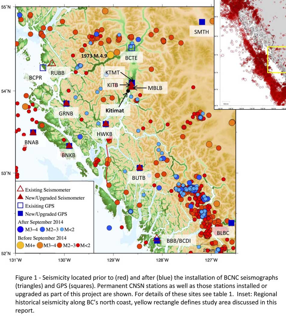
A Geological Survey of Canada map showing the BC North Coast region with earthquakes identified prior to and during recent studies. (Geological Survey of Canada)
The Geological Survey says that historically “the BCNC has been seismically quiescent.” As a result “seismic monitoring and research related to the BCNC has been minimal.” That meant while larger earthquakes were “felt and recorded,” the configuration of the Canadian National Seismograph Network did not allow earthquakes less than approximately magnitude 2.1 to be monitored in northern BC.
Now the Geological Survey is looking at “long-term, continuous monitoring of micro seismicity, combined with geodetic and paleo seismic techniques” that could be used to study at the possibility of large earthquakes, including a possible fault on the lower Douglas Channel.
Since the studies began in August 2014, the Geological Survey identified 145 earthquakes within the study area, many too small to be felt since they are less than magnitude 2.0. Those earthquakes, however, were picked up by the new and improved instrumentation used by the earthquake monitors.
The two reports one on “seismic hazards” and the second on “geohazards” says five “temporary seismonitors” (download reports from links below) were installed within the BCNC while some older stations were upgraded, saying, “It is expected that these new stations will be aid in locating small earthquakes” that were not previously detected by the existing network. The Geological Survey also installed ground movement monitoring GPS units along the coast.
The use of the term “temporary” raises the question about how much ongoing monitoring is planned.
The study also notes that the current data is not included in the seismic standards in the current National Building Code of Canada, which in turn is based on the Natural Resources Canada Seismic Hazard Map. That may mean that municipalities in the BC North Coast region, in the future, as the seismic studies continue, may have to consider updating building codes, especially in areas of “softer soils” as opposed to harder rock.
“Fault-like structure” on Douglas Channel
Detail of a map from the Geological Survey of Canada where the red line shows the 60 kilometre possible (still unconfirmed) fault line running from Gribbell Island to Princess Royal Island (Geological Survey of Canada)
Over the years some small earthquakes have also been recorded on what the Geological Survey calls the “recently mapped fault-like structure” on Douglas Channel which was discovered in 2012. The survey is still calling it “fault-like” because it has not yet been confirmed as an active fault. A new map in the study shows that the “fault” runs from the southern tip of Gribbell Island, down the centre of Whale Channel east of Gil Island and then along the western coast of Princess Royal Island.
The study identified “a small, unfelt swarm of earthquakes between magnitude 1.7 and 2.0 between September 13 and 14, 2010 near Gil Island.”
There is also the previously identified ancient Grenville Channel Fault (ancient and believed inactive because it dates from the Cretaceous, the age of the dinosaurs) that runs from along Grenville Channel from Porcher Island in the north to Klemtu in the south which has experienced small earthquakes.
The report says geological studies of the Douglas Channel “fault-like structure” are a priority because, “Should this structure be determined to be an active fault, it would pose significant risk of earthquake-triggered landslides (and subsequent tsunami) from the susceptible Douglas Channel hill slopes.”
Clay and sand in Kitimat
The report also calls for more studies the local geology and soil conditions in the Kitimat Valley. A study back in 1984 by John Clague of Simon Fraser University showed that as the glaciers retreated during the last Ice Age there were “periods of stagnation” resulting in sediments that are thicker than other regions of British Columbia, Clague reported that in parts of Kitimat, the glacial moraine is hundreds of metres thick.
After the glaciers were gone, the sea levels rose and glaciomarine sediments (clay, silt up to 60 metres thick) were deposited until the sea level fell to present-day levels. The report says that as these marine deposits were exposed to fresh water, salts were leached out resulting in saturated, porous sediments, including clay, which are prone to failure. Boreholes in the Kitimat area show that the clay and sediments above the bedrock can range from 17 metres to 106 metres.
The report notes the presence of clay soils “can amplify ground shaking and secondary effects” as happened in November 1988 when there was an earthquake in the Saguenay region of Quebec.
Originally reported as a 6.2 magnitude but later downgraded to 5.9, on Nov. 25, 1988, the major earthquake was centered near the Quebec cities of Chicoutimi and Jonquière, with aftershocks felt as far away as Toronto, Halifax and Boston. The quake lasted for two minutes, catching thousands of people off guard and leaving buildings damaged and power out for hundreds of thousands of Quebecers.
The report says the most significant event within the BC North Coast study region (which as mentioned doesn’t include Haida Gwaii) was a magnitude 4.9 earthquake approximately 20 kilometers southwest of Terrace on November 5, 1973, which was felt as far as 120 kilometers away, with some minor damage (broken windows and cracked plaster) reported near the epicentre. The main shock at Terrace was preceded by a magnitude 2.5 foreshock four hours before, and followed by a felt magnitude 3.7 aftershock the next day.
Bella Bella at risk
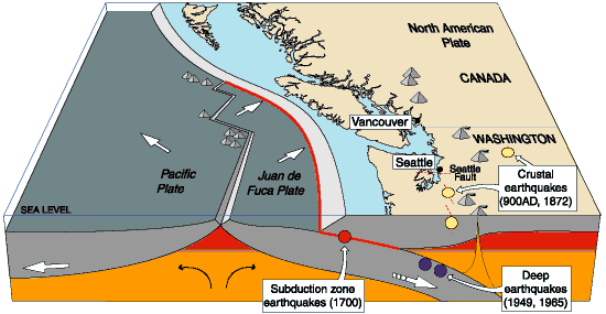
Another area most at risk, according to the report, is southern part of the BC North Coast zone, near Bella Bella, which is close to the northern section Cascadia Subduction Zone a “1,000 kilometre long dipping fault that stretches from Northern Vancouver Island to Cape Mendocino California” which one day will cause a major earthquake along the fault.
Cascadia subduction zone (USGS)
The report says that a magnitude 9.0 or higher earthquake in the northern Cascadia Subduction zone close to Bella Bella would be similar to the March 2011 earthquake in Japan and the 1964 Good Friday earthquake in Alaska.
For the northern part of the BC North Coast region, hazards could come from either a major earthquake off Haida Gwaii or a similar earthquake in south-eastern Alaska.
The greatest hazard would come from “long period” earthquakes greater than magnitude 6.75 with an epicentre between 300 and 350 kilometers away where the shaking lasts longer than one second.
The Geological Survey modeled three possible scenarios for major earthquakes in the BC North Coast Region.
Model #1. A magnitude 8.0 Earthquake at Haida Gwaii
The Geological Survey Canada model for an 8.0 magnitude earthquake west of Haida Gwaii. The possible damage is colour coded in the table below the map according to the Modified Mercalli Intensity Scale. The red polygon represents the area of possible rupture in the model with the star representing the epicentre. (Geological Survey of Canada)
The model looked at a “plausible maximum predicted” magnitude 8.0 thrust fault earthquake off the west coast of Haida Gwaii which would be twice as strong in the fault area as the 7.8 quake on October 28, 2012 (Remember Magnitudes are based on a logarithmic scale. That means for each whole number higher, the amplitude of the ground motion recorded by a seismograph goes up ten times so magnitude 8 earthquake would result in ten times the ground shaking as a magnitude 7 earthquake)
For a short period earthquake, the report estimates that there would be minimal damage on Haida Gwaii similar to the damage from the 2012 earthquake with little or no damage on the BC North Coast.
A long duration, long period earthquake that lasted longer than one second and up to three seconds or longer “may effect taller structures and trigger ground failure (that is liquefaction and lateral shaking).” Kitimat would feel that earthquake with the worst shaking in parts of the District with what the report calls “sensitive soils.” Coastal islands would feel double the amount of shaking as would occur in Kitimat.
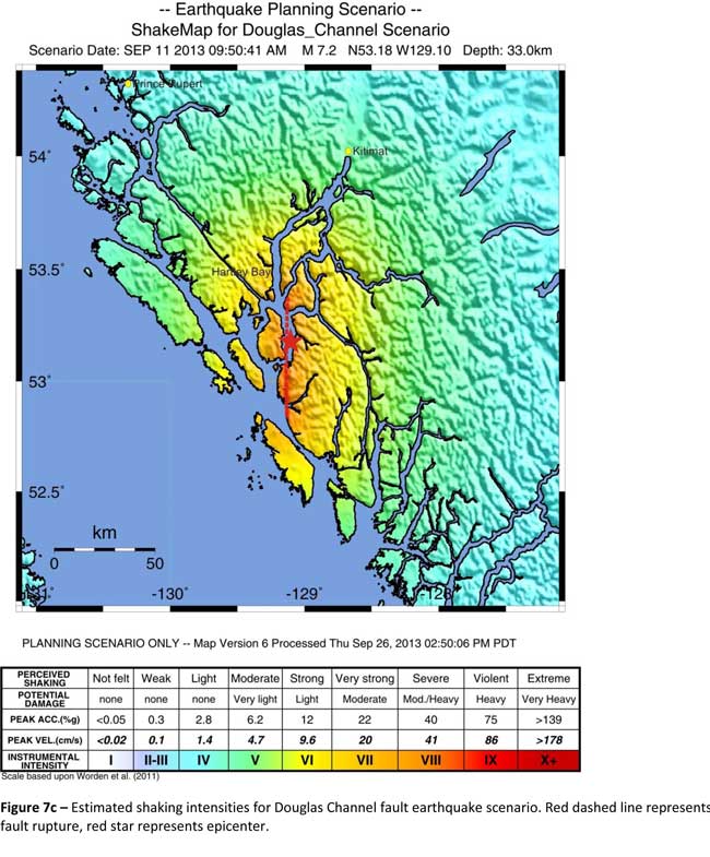
Model #2. A magnitude 7.2 Earthquake in Douglas Channel
The Geological Survey Canada model for a 7/2 magnitude earthquake in the lower Douglas Channel. The possible damage is colour coded in the table below the map according to the Modified Mercalli Intensity Scale. The red star represents the possible epicentre. (Geological Survey of Canada)
The second model looked at an earthquake in Douglas Channel based on the “fault like structure” if a slip strike rupture occurred along the entire 60 kilometers of the so far unconfirmed fault, resulting in a 7.2 magnitude earthquake. There would be very strong shaking within 20 kilometers radius of the epicentre, with moderate to heavy damage” in the relatively uninhabited islands, major shaking in Hartley Bay, resulting in very strong to strong damage at Hartley Bay and strong to moderate damage in Kitimat.
That earthquake, however, would be felt across the entire province of British Columbia. The report notes:
The expected effects and impacts of such an earthquake would mimic those of the 1946 magnitude 7.3 Vancouver Island earthquake, which occurred slightly west of Courtney and Campbell River. Shaking due to the 1946 earthquake was felt as far as Prince Rupert, BC to the north and Portland, Oregon to the south. In addition to knocking down 75 per cent of the chimneys in the local area, much of the earthquake-related damage was due to landslides, slumping and liquefaction
Model #3 A magnitude 6.3 Earthquake near Terrace
The Geological Survey Canada model for an 6.3 magnitude earthquake southwest of Terrace. The possible damage is colour coded in the table below the map according to the Modified Mercalli Intensity Scale. The red polygon represents the area of possible rupture in the model with the star representing the epicentre. (Geological Survey of Canada)
On May 11, 1973, a magnitude 4.7 shallow earthquake took place about 20 kilometers south west of Terrace, on the south side of the Skeena roughly across from the Shames mountain area. The earthquake was felt up to 120 kilometers away. The report says “The event has not been associated with any geologic features in the area and little is known about its rupture process.” The model estimated the results of a larger earthquake 6.3 magnitude in the same area. The model showed there would be strong to very strong shaking in Terrace, light to moderate shaking in Kitimat and light damage elsewhere in the BC North Coast. Most of the damage would be concentrated in a 20 kilometer zone around the epicentre.
The cause of the two failures is still unknown but the report says “their proximity to a nearby unmapped fault-like structure suggests that the slides could have been triggered by strong ground shaking from rupture along this structure.”
Another factor was the two well-known landslides occurred in the 1970’s in the Kitimat Arm which generated tsunamis but fortunately they occurred at low tide which decreased the impact. On October 17, 1974 a submarine slide generated a 2.8 metre tsunami. The following year on April 27, 1975, a slope failure on the northeast side of Kitimat Arm (which overlapped the 1974 failure area) displaced an estimated upper limit of 26,000,000 cubic metres of material.
“Watermark observations in Kitamaat Village estimated that the tsunami generated by this slide was up to 8.2 metres high.” The report says that while the trigger of the first event is unknown; the latter event coincided with nearby construction at that time. Modelling of the 1975 slide estimates that given the right conditions the generated tsunami waves could have been as high as 11 metres.
The report also notes that numerous landslides have also been mapped by the BC Department of Forestry in an attempt to improve safety measures for forestry workers.
The report says “The culmination of these studies brings awareness to the significant natural hazards present in the fragile coastal environment of the Coast Ranges.”
Another factor is the geology of the BC coast. The granitic mountains have rugged, steep slopes dissected by an intricate fjord system and dotted with islands of lower elevation. At lower elevations the land is covered by wet, coastal hemlock forests, which could be vulnerable to ground failures whereas higher elevations are characterized by barren rock or mountain hemlock subalpine.
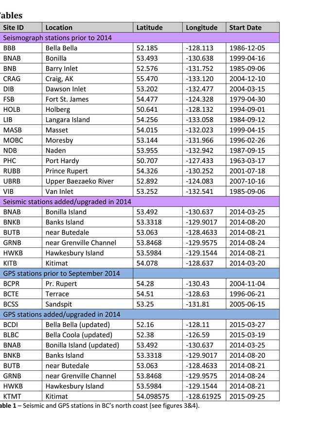
Table of Seismic monitoring and GPS stations in northern BC from the Geological Survey of Canada (Geological Survey of Canada)
The District of Kitimat said it has “not directly studied these issues but we are aware of potential hazards.” The development department has been advised of potential issues and site concerns.
A spokesperson for Terrace mayor Carol Leclerc told Northwest Coast Energy News in an e-mail. “I have reviewed it and distributed it to the relevant department heads. We are aware that historically Terrace has been at risk for experiencing seismic activity due to its location.”
The District of Kitimat did cooperate with National Resources in finding a location for their recently installed seismic equipment.
At Harley Bay, Gitga’at First Nation CEO Ellen Torng said the Gitga’at have been “ working with NRCan on their research in the Douglas Channel and in Hawksbury. NRC has been meeting with First Nations along the coast and have conducted community sessions on their research.
“We hosted one community session here in Hartley Bay and have regular updates from their technical team when they are in the area,” Torng said.
In addition, the District of Kitimat told Northwest Coast Energy News that Community Planning & Development department also provided local land information to geoscientists in the years leading up an international study called Batholiths on land in 2009.
Batholiths are large zones of molten rock that have solidified in the earth’s crust and are believed to play a key role in the formation and growth of continents. The Coast Mountain Range has a large concentration of batholiths, which means Kitimat was an excellent place to study the earth’s crust.
The project, which involved more than 50 scientists from nine Canadian and American universities, was set up to examine how mountain belts form and change over time and why continental mountain ranges are made of granite not basalt. Seismic imaging of the crust and mantle below the mountains required deploying thousands of seismic sensors and recorders, and recorded responses to several man-made detonations. Field work was completed in July 2009, and several scientific papers and dissertations have followed.
The Heiltsuk Nation was unable to respond to a request for comment due to the ongoing crisis from the sinking of the tug Nathan E. Stewart and the resulting spill of diesel fuel and other contaminants near Bella Bella.
Not felt except by a very few under especially favorable conditions.
II
Weak
Felt only by a few persons at rest,especially on upper floors of buildings.
III
Weak
Felt quite noticeably by persons indoors, especially on upper floors of buildings. Many people do not recognize it as an earthquake. Standing motor cars may rock slightly. Vibrations similar to the passing of a truck. Duration estimated.
IV
Light
Felt indoors by many, outdoors by few during the day. At night, some awakened. Dishes, windows, doors disturbed; walls make cracking sound. Sensation like heavy truck striking building. Standing motor cars rocked noticeably.
V
Moderate
Felt by nearly everyone; many awakened. Some dishes, windows broken. Unstable objects overturned. Pendulum clocks may stop.
VI
Strong
Felt by all, many frightened. Some heavy furniture moved; a few instances of fallen plaster. Damage slight.
VII
Very strong
Damage negligible in buildings of good design and construction; slight to moderate in well-built ordinary structures; considerable damage in poorly built or badly designed structures; some chimneys broken.
VIII
Severe
Damage slight in specially designed structures; considerable damage in ordinary substantial buildings with partial collapse. Damage great in poorly built structures. Fall of chimneys, factory stacks, columns, monuments, walls. Heavy furniture overturned.
IX
Violent
Damage considerable in specially designed structures; well-designed frame structures thrown out of plumb. Damage great in substantial buildings, with partial collapse. Buildings shifted off foundations.
X
Extreme
Some well-built wooden structures destroyed; most masonry and frame structures destroyed with foundations. Rails bent.
British Columbia says it is implementing new radio protocols for forest service roads in the Kitimat region that will take effect on November 2.
The news release from Ministry of Forests, Lands and Natural Resource Operations says:
New mobile radio communication protocols are being
implemented throughout B.C. to improve safety for resource road
users. The changes include new standardized road signs, radio call
protocols and a bank of standardized mobile radio channels.
The Coast Mountain Natural Resource District will be implementing new
resource road radio channels beginning Nov. 2, 2015. The district
covers over 80,000 square kilometres and includes the major centres
of Terrace, Kitimat, Prince Rupert, New Aiyansh and Stewart.
The new protocols will impact forest service roads and other road
permit roads in the area. All affected road users must have the new
channels programmed into their mobile radios before the transition
dates. Mobile radio users are advised to retain current radio
channels and frequencies until they are no longer required.
It is recommended that mobile radio users have the full bank of
standardized resource road radio channels programmed into their
radios by certified radio technicians.
New signs posted on local resource roads will advise which radio
channels to use and provide the communication protocols, including
the road name and required calling intervals. Vehicle operators using
mobile radios to communicate their location and direction of travel
must use the posted radio channels and call protocols.
All resource road users in the affected areas should exercise
additional caution during the transition period. Drivers are reminded
that forest service roads are radio-assisted, not radio-controlled,
and to drive safely according to road and weather conditions.
Local resource road safety committees have worked with the Ministry
of Forests, Lands and Natural Resource Operations and Industry Canada
to implement these changes.
A Portuguese man was fined $1 in Terrace Provincial Court Wednesday Sept. 2 and ordered to donate $5,000 to the Heritage Conservation Trust Fund for hitting a swimming deer on the head off Bish Cove in Douglas Channel on May 14.
Rodolfo Lopes, previously misidentified in court documents as Martins-Lopes, pleaded guilty in to one count under the BC Wildlife Act of harassing wildlife with a motor vehicle.
Evidence in the case showed that Lopes hit the deer on the head with a jig or gaff in an attempt to bring it on board. The deer managed to escape and make it to shore.
Such donations are permitted under the BC Wildlife Act. The money, which Lopes originally paid in bail, will be allocated to conservation efforts in the Kitimat region.
Other charges against Lopes, a former supervisor at the Rio Tinto Alcan Kitimat Modernization Project, including one count of causing unnecessary pain and suffering to an animal under the Criminal Code were stayed by the Crown.
Provincial Court Judge Terence Wright also prohibited Lopes from approaching wildlife for the next two years unless required by his employment.
Lopes did not return from Portugal for the hearing. Vancouver lawyer Don Sorochan, QC, appeared on his behalf.
Crown counsel Corinne Baerg said Lopes was a supervisor at Brasco, one of the subcontractors at KMP, and had hired a fishing guide to help celebrate both the end of their work at the aluminum smelter modernization project and Lopes’ planned wedding in August.
After a day of what was apparently unsuccessful fishing, Lopes and five others were on board the boat, returning to Kitimat, when a deer was spotted swimming in Douglas Channel.
According to the submission, the guide then took the boat “ running up alongside” the deer. At that point Lopes hit the deer on the head with what some witnesses said was a jig and others said was a gaff in attempt to haul it on board. The deer was able to free itself, swam to shore and disappeared into the bush.
After Conservation Officers were told about the incident by residents in Kitimat who saw a video of the fishing trip on Facebook, one of the men on the boat voluntarily surrendered cell phone video and other evidence was seized under a search warrant. The video was not shown in court.
Because Lopes was not a Canadian resident he was arrested and spent time in custody before being granted bail and was permitted to return to Portugal.
In his defence submission, Sorochan said Lopes was not familiar with Canadian hunting and wildlife laws and was totally dependent on the “advice of his professional guide.” Sorochon told the court that the incident had become exaggerated by people gossiping on social media.
Sorochan told the court that Lopes began with Brasco as a bricklayer in 1996 and had quickly risen to supervise construction projects all over the world. The lawyer called the attempt to get the deer “a naive impulse” by a man who was trying to be macho in an unfamiliar setting.
He submitted letters of reference for Lopes from Brasco, another company and a Kitimat union.
Wright, in confirming the proposed sentence, said that given the circumstances, the fine and donation was the “appropriate penalty.”
Wright noted that it was not possible to ascertain how badly injured the deer was. He also noted that Lopes did not have a criminal record and his employer had praised his work in many parts of the world.
Andreas Handl, who runs Kitimat’s Kingfish Westcoast Adventures, was scheduled to appear in a Kitimat court Thursday, Sept 3, but the appearance was adjourned until October.
He is charged under the B.C. Wildlife Act with harassing wildlife with a motor vehicle and hunting wildlife while swimming, as well as causing unnecessary pain and suffering under the Criminal Code.
Councillor Phil Germuth questions Northern Gateway officials about their plans for leak detection, Feb. 17, 2014 (Robin Rowland/Northwest Coast Energy News)
Enbridge Northern Gateway officials are loath (to put it mildly) to speak to the media but sometimes they let things slip. Earlier this summer, at a social event, I heard an Enbridge official (probably inadvertently) reveal that when the company’s engineers came before District of Kitimat Council earlier this year they were surprised and somewhat unprepared to fully answer the detailed technical questions from Councillor Phil Germuth on pipeline leak detection.
The results of the municipal election in Kitimat, and elsewhere across BC show one clear message; voters do want industrial development in their communities, but not at any price. Communities are no longer prepared to be drive by casualties for giant corporations on their road to shareholder value.
The federal Conservatives and the BC provincial Liberals have, up until now, successfully used the “all or nothing thinking” argument. That argument is: You either accept everything a project proponent wants, whether in the mining or energy sectors, or you are against all development. Psychologists will tell you that “all or nothing thinking” only leads to personal defeat and depression. In politics, especially in an age of attack ads and polarization, the all or nothing thinking strategy often works. Saturday’s results, however, show that at least at the municipal level, the all or nothing argument is a political loser. Where “all politics is local” the majority of people are aware of the details of the issues and reject black and white thinking.
Northern Gateway’s Ray Philpenko gives a presentation on pipeline leak detection to Kitimat Council, Feb. 17. 2014. (Robin Rowland/Northwest Coast Energy News)
The Enbridge official went on to say that for their company observers, Germuth’s questions were a “what the…..” moment. As in “what the …..” is this small town councillor doing challenging our expertise?
But then Enbridge (and the other pipeline companies) have always tended to under estimate the intelligence of people who live along the route of proposed projects whether in British Columbia or elsewhere in North America, preferring to either ignore or demonize opponents and to lump skeptics into the opponent camp. The Northern Gateway Joint Review Panel also lost credibility when it accepted most of Northern Gateway’s arguments at face value while saying “what the ……” do these amateurs living along the pipeline route know?
Pro Development
“I am pro-development,” Germuth proclaimed to reporters in Kitimat on Saturday night after his landslide victory in his campaign for mayor.
On the issue of leak detection, over a period of two years, Germuth did his homework, checked his facts and looked for the best technology on leak detection for pipelines. That’s a crucial issue here where pipelines cross hundreds of kilometres of wilderness and there just aren’t the people around to notice something is amiss (as the people of Marshall, Michigan wondered at the time of the Line 6B breach back in 2010). Enbridge should have been prepared; Germuth first raised public questions about leak detection at a public forum in August 2012. In February 2014, after another eighteen months of research, he was ready to cross-examine, as much as possible under council rules of procedure. Enbridge fumbled the answers.
So that’s the kind of politician that will be mayor of Kitimat for the next four years, technically astute, pro-development but skeptical of corporate promises and determined to protect the environment.
Across the province, despite obstacles to opposition set up by the federal and provincial governments, proponents are now in for a tougher time (something that some companies will actually welcome since it raises the standards for development).
We see similar results in key votes in British Columbia. In Vancouver, Gregor Roberston, despite some problems with policies in some neighborhoods, won re-election on his green and anti-tankers platform. In Burnaby, Derek Corrigan handily won re-election and has already repeated his determination to stop the twinning of the Kinder Morgan pipeline through his town. In Prince Rupert, Lee Brain defeated incumbent Jack Musselman. Brain, who has on the ground experience working at an oil refinery in India, supports LNG development but has also been vocal in his opposition to Northern Gateway.
The new mayor in Terrace Carol Leclerc is an unknown factor, a former candidate for the BC Liberal party, who campaigned mainly on local issues. In the Terrace debate she refused to be pinned down on whether or not she supported Northern Gateway, saying, “Do I see Enbridge going ahead? Not a hope,” but later adding, “I’d go with a pipeline before I’d go with a rail car.”
Kitimat election signs. (Robin Rowland/Northwest Coast Energy News)
Plebiscite confirmed
Kitimat’s mayor and council elections also confirm that Northern Gateway plebiscite vote last April. Kitimat wants industrial development but not at the price of the community and the environment. The unofficial pro-development slate lost. A last minute attempt to smear Germuth on social media was quickly shot down by people from all sides of the Kitimat debate. Smears don’t usually work in small towns where everyone knows everyone.
Larry Walker, an environmentalist with a track record in municipal politics as an alderman in Spruce Grove, Alberta, won a seat. Together with Rob Goffinet and Germuth, that is three solid votes for the environment. The other new councillor is Claire Rattee who will be one to watch. Will the rookie be the swing vote as Corinne Scott was?
Mario Feldhoff who came to third to Goffinet in the overall vote (Edwin Empinado was second) is a solid councillor with a strong reputation for doing his homework and attention to detail and the unofficial leader of the side more inclined to support development. Feldhoff got votes from all sides in the community.
During the debates, Feldhoff repeated his position that he supports David Black’s Kitimat Clean refinery. But as an accountant, Feldhoff will have to realize that Black’s plan, which many commentators say was economically doubtful with oil at $110 a barrel, is impractical with oil at $78 a barrel for Brent Crude and expected to fall farther. Any idea of a refinery bringing jobs to Kitimat will have to be put on hold for now.
LNG projects are also dependent on the volatility and uncertainty in the marketplace. The companies involved keep postponing the all important Final Investment Decisions.
There are also Kitimat specific issues to deal with. What happens to the airshed, now and in the future? Access to the ocean remains a big issue. RTA’s gift of land on Minette Bay is a step in the right direction, but while estuary land is great for camping, canoeing and nature lovers, it is not a beach. There is still the need for a well-managed marina and boat launch that will be open and available to everyone in the valley.
Germuth will have to unite a sometimes contentious council to ensure Kitimat’s future prosperity without giving up the skepticism necessary when corporations sit on a table facing council on a Monday night, trying to sell their latest projects. That all means that Germuth has his job cut out for him over the next four years.
There’s a dumb, dumb, really dumb idea that just won’t go away—that Enbridge could solve all its problems if only, if only, it would send the Northern Gateway Pipeline to Prince Rupert.
Enbridge long ago rejected the idea. Before Enbridge updated its website to make Gateway Facts, to make it slick and more attractive, the old website had an FAQ where Enbridge explained why it wasn’t going to Prince Rupert.
Did you consider running the pipeline to Prince Rupert where a major port already exists?
We considered Prince Rupert and Kitimat as possible locations. We carried out a feasibility study that took into account a number of considerations. The study found that the routes to Prince Rupert were too steep to safely run the pipeline, and that Kitimat was the best and safest option available.
Current proposed route for the Northern Gateway pipeline. (Enbridge)
Here in the northwest even the supporters of the Northern Gateway roll their eyes when they hear the old Prince Rupert story come up again and again – and it’s not just because these people support the Kitimat plans for Northern Gateway, it’s because those supporters (not to mention the opponents) have driven along the Skeena from Terrace to Prince Rupert.
There just isn’t any room for a pipeline. It’s a game of centimetres.
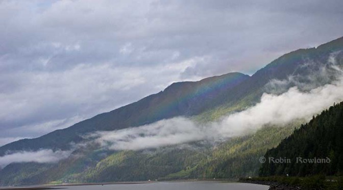
A rainbow hugs the mountains near the Telegraph Point rest area on the Skeena River between Terrace and Prince Rupert, Sept. 29, 2014. Traffic is seen on the narrow corridor between the mountains and the river (Robin Rowland/Northwest Coast Energy News)
Alternatives to Kitimat?
Now the new premier of Alberta, Jim Prentice, who should know better if he’s going to lead that province, is hinting that Kitimat isn’t the only possible solution for the Northern Gateway.
Without specifying Prince Rupert, according to Gary Mason reporting in The Globe and Mail, Prentice was speculating about an alternative to Kitimat.
Asked whether he believes the Gateway terminus should be relocated to Prince Rupert or another destination, Mr. Prentice said, “Everything I’ve heard from the Haisla who live there is they don’t agree with the terminal being in Kitimat.” Is it possible to get First Nations approval if there is no support at the planned terminus site? “It’s pretty tough,” the Premier said.
Prince Rupert has a thriving local fishing industry that employs hundreds of people and is critically important to the local First Nations. He is convinced the community would not be willing to put that at risk.
“Overwhelmingly people in my community are much more comfortable with liquefied natural gas, with wood pellets, with coal, than any oil product,” he said.
The Prince Rupert Port Authority also rejected the idea
A spokesman for the Prince Rupert Port Authority said Wednesday there is currently no room for Enbridge to build at the port even if it wanted to. “We are fully subscribed,” Michael Gurney said. There are two large vacant lots within the port authority’s jurisdiction, but both are locked by other energy companies, earmarked for LNG projects.
So not only is there no room on the road to Prince Rupert, there is no room in Prince Rupert.
Shovel-ready?
Let’s just consider for a moment that if Prince Rupert was the ideal location for the Northern Gateway terminal (which it is not), what would be needed to get the project going today.
The Northern Gateway Joint Review Panel would have be reconstituted or a new JRP created by the National Energy Board. That’s because the bitumen comes from Bruderheim, Alberta, crossing provincial boundaries and thus it’s in federal jurisdiction.
Even under the fast track rules imposed on the NEB by Stephen Harper’s Conservative government, new environmental and social impact studies would be required, starting from scratch. So add another five years of paperwork before a single shovel goes into the ground.
The pipeline would have to cross the traditional territory of First Nations that, so far, have not been part of the negotiations, mostly the Tsimshian First Nation as well as the Nisga’a First Nation which has a treaty establishing local rule over their territory.
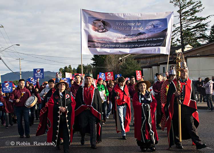
Traditional leaders of the Gitga’at First Nation lead a protest march through the streets of Prince Rupert, February 4, 2012. (Robin Rowland/Northwest Coast Energy News)
In February 2012, the largest anti-Enbridge demonstration outside of the Lower Mainland took place in Prince Rupert, with the elders of the Tsimshian First Nation welcoming the elders and members of the Gitga’at First Nation, at Hartley Bay, which had organized the protest.
When I say there isn’t room for a pipeline along the Skeena, it also means that there isn’t any room for the pipeline corridor right-of-way. Enbridge, in its submissions to the Joint Review Panel, said it requires a 25 metre wide right of way for the pipeline corridor. (For the record that’s just over 82 feet).
Along that highway, as you will see, there’s barely enough room for the CN mainline and Highway 16 (also known as the Yellowhead Highway) and on a lot of places both the highway and the railway roadbed are built on fill along the side of a cliff.
Albertans’ desperate desire to see the Northern Gateway go to anywhere to what they call “tide water” keeps coming up like the proverbial bad penny. The latest came when Jim Prentice speculated about a new route for the Northern Gateway.
I knew I had an appointment coming up in Prince Rupert on Monday, September 29. So I decided that only way to prove to people sitting in Calgary, Edmonton and Fort McMurray playing with Google Maps that the pipeline to Prince Rupert was a really dumb idea was to shoot photographs to show just why the Northern Gateway will never go to Prince Rupert—at least along the Skeena.
As you drive out of Terrace, you pass two large swing gates (also called by some “Checkpoint Charlie” gates after the Cold War era crossing in Berlin.) At the first rest stop west of Terrace, there are another set of gates at the Exstew. There’s a third set of gates just outside Prince Rupert.
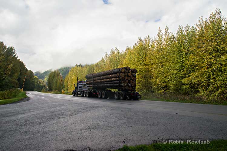
A logging truck passes the avalanche gates at Exstew on Highway 16, Sept. 29, 2014. (Robin Rowland)
The swing gates are avalanche gates and, in the winter, Highway 16 can be shut down if an avalanche closes the highway or the danger from avalanche is too great to allow motorists to proceed. When you drive the highway from Terrace to Prince Rupert in the winter (the signs were covered up when I drove Monday) you are warned “Avalanche danger Next 13 kilometres. No stopping.”
The Exstew avalanche gates, (Robin Rowland/Northwest Coast Energy News)
The drive along the Skeena from just west of Exchamsiks River Provincial Park all the way to Tyee where the highway turns inland to reach northwest to Prince Rupert on Kaien Island is one of the most spectacular drives on this planet. The highway snakes along a narrow strip of land with steep mountain cliffs on one side and the vast river on the other.
The problem is that apart from locals and tourists, none of the “experts” whether journalist, think tanker, bureaucrat or politician have, apparently ever driven from Prince Rupert to Terrace.
When both Opposition Leader Tom Mulcair and Liberal Leader Justin Trudeau were in the northwest earlier this summer to “engage” with the local people, apart from short boat trips down Douglas Channel, they flew everywhere. Scheduling you know. Stephen Harper has never visited northwest BC and probably never intends to. His cabinet members fly in for photo ops and then are on the next plane out of town.
Of all the visiting journalists who have come to the northwest only a couple have bothered to drive around the region. Most fly-in fly-out. These days, most often budget-strapped reporters never leave their offices, interviewing the same usual suspects by phone on every story.
On Monday, I took most of the photographs on my way back from Prince Rupert to Terrace after my appointment, so the sequence is from west to east. There are also very few places along the river where you can safely stop. There are concrete barricades on both sides of the highway to prevent vehicles either going into the river or onto the narrow CN right-of-way.
There are, however, two rest stops and a number of small turnoffs on the highway, the turnoffs mainly intended for use by BC Highways, but which are also used by tourists, fishers and photographers.
The first image was taken at one of those highway turnoffs just east of Aberdeen Creek. This is what the highway and rail corridor are like all along the Skeena, the highway, bounded by concrete barricades, the CN rail line and then the towering mountains. Note where the telegraph and telephone lines are—further up the cliffside.
A closer view of the highway and rail corridor just east of Aberdeen Creek.
Here is the view of the Skeena River from the Aberdeen Creek turnoff. You can see to the east, a mountain and the narrow strip of fill land that supports the highway and the rail line.
You see the broad width of the mighty Skeena, the Misty River, as it is called by the Tsimshian First Nation and by everyone else who lives in the northwest and on the right side of the image, the highway and rail corridor built on fill.
Any room for a pipeline?
There’s another turnoff on the other side of the headland east of Aberdeen Creek, looking back the way we came.
The final small turnoff is just by the Kylex River. Again you can see how narrow the highway and rail corridor are.
A few kilometres further along—as I said the highway snakes and curves its way along the riverbank– you come to the Basalt Creek rest area. So this telephoto image shows a logging truck heading west, taken from Basalt Creek, looking back at the highway.
Again you can see both the highway and CN line are built on fill. Is there any room for a pipeline?
Any room for a 25 metre pipeline right-of-way?
Between Basalt Creek and Telegraph Point, a few kilometres to the east, again the highway and rail line hug the narrow strip between the river and mountains.
This shot, taken from Telegraph Point, in October 2013, shows a CN intermodal container train heading to Prince Rupert. The container trains and the coal trains usually have between 150 and 180 cars. If a winter avalanche took out a train, there would be environmental damage, but that damage would be insignificant from coal or containers compared to a train of railbit tankers carrying diluted bitumen.
At Telegraph Point, the second of the three rest stops between Prince Rupert and Terrace, again there is just a narrow strip between the mountain, the highway and the river.
Across the highway from the rest stop, you can again see the narrow corridor, the first shot looking west the rail line close to the cliff face, the second, east, with the waterfall, which you don’t see during the rest of the year, fed by the fall monsoon.
Two shots from the same location, Telegraph Point, taken in March, 2013, of a CN locomotive hauling empty coal cars back to the fields around Tumbler Ridge. (No waterfall in March)
Alternative routes
Everyone has assumed that if Northern Gateway changed its route, the most likely choice given the configuration of the pipeline at the moment is to follow the Skeena.
There are alternatives. The Petronas LNG project and its partner TransCanada Pipelines have proposed a more northern cross-country route, which would go north from the Hazeltons, avoiding the Skeena
If Enbridge wanted to try a northern route, similar to the one TransCanada contemplates for Petronas, Northern Gateway would again run into trouble.
It would require reopening or creating a new Joint Review Panel, many more years of environmental and social impact studies of the route, even under Stephen Harper’s fast track system. The TransCanada/Petronas pipeline would also cross the traditional territory of the Gitxsan First Nation and if Enbridge tried that the company would have to deal with the fact that it signed a controversial agreement with Elmer Derrick that was immediately repudiated by most members of the Gitxsan First Nation and eventually dropped by Enbridge.
So why does this idea of a pipeline to Prince Rupert keep coming up?
In most cases, the idea of the pipeline to Prince Rupert is always proposed by Albertans, not from any credible source in British Columbia, or the suggestions come from desk bound analysts in Toronto and Ottawa both in think tanks and in the newsrooms of dying newspapers who have never seen the Skeena River apart from a tiny handful who have looked at Google Street View
(Yes you can Google Street View Highway 16 along the Skeena, I recommend it if you can’t do the drive)
Perhaps the worst example of this failure of both analysis and journalism came in the Edmonton Journal on July 7,2014, when it published a piece by Bob Russell, entitled Opinion: Make Prince Rupert the terminus, which went over the same old inaccurate arguments.
The overland route currently proposed by Enbridge is fraught with environmental issues because it goes over coastal mountains and streams before entering Kitimat’s port. This port will also be the base of perhaps as many as four liquefied natural gas terminals, which will result in the channel always busy with LNG ships outbound and returning from many Asian ports.
There are existing rights of way for the major highway, the Yellowhead, and CN Rail line from Edmonton to the Port of Prince Rupert, so this eliminates the issue of transgressing First Nations lands. The technical issues of narrow passages can be overcome with engineering. In fact, the pipeline can be buried in the roadway at some restricted locations if absolutely necessary, but two different engineers have assured me that for the most part, the right of way should be able to handle the pipeline. A vital factor, of course, is to reduce the impact by eliminating the need for two pipelines.
The clue is how the Edmonton Journal describes Russell;
Bob Russell has an extensive background in planning and was a member of the Edmonton Metro Regional Planning Commission. He has flown the Douglas Channel, visited Kitimat and toured the Port of Prince Rupert.
This is so typical of the Albertan attitude toward northwest British Columbia, people fly in for a couple of days, make a quick observation, and fly out again and present themselves as experts on the region. (Some “experts” on Kitimat, very active on Twitter have apparently never left Calgary).
It obvious that the “two engineers” who assured him “the right-of-way could handle of pipeline” have no idea what they’re talking about. As the photos show there is barely enough room for a highway and a rail line much less a 25 metre wide pipeline corridor.
If the pipeline was to be built as Russell proposed, the only highway between Prince Rupert and the rest of Canada would have to be closed for years, there are no detours. All so a pipeline can be buried under the asphalt not in solid ground, but in the fill on the side of a riverbank in an avalanche zone?
Of course, closing a highway up here won’t inconvenience anyone in Edmonton or Calgary, will it?
Would CN be happy with years of disruption of their lucrative traffic to Prince Rupert with grain and coal outbound to Asia and all those containers coming in to feed Chinese products to the North American market? (you can be sure Walmart wouldn’t be happy about that, not to mention prairie farmers including those from Alberta)
Russell’s statement
There are existing rights of way for the major highway, the Yellowhead, and CN Rail line from Edmonton to the Port of Prince Rupert, so this eliminates the issue of transgressing First Nations lands.
Is also inaccurate.
I was told by First Nations leaders during the Idle No More demonstrations in the winter of 2013, that, a century ago, when the Grand Trunk built the railway along the Skeena , they did just that, built it without consulting the First Nations along the route, sometime digging up native cemeteries and sacred spots.
While apparently CN has worked in recent years to improve relations with the First Nations along the rail line, according to those leaders some issues of right-of-way remain to be resolved.
If there were any plans to build a diluted bitumen pipeline along that route, that would likely mean another court battle adding to those already before the Federal Court, a court battle that would cost Enbridge, CN, the federal government, environmental NGOs and the First Nations more millions in lawyers’ fees.
It’s doubtful if in the long gone (and perhaps mythical) days of “get it right” journalism that the Russell opinion piece would have passed the scrutiny of an old fashioned copy editor and fact checker.
In 2012, the Edmonton Journal (in a story no longer available on their website) also cited former Alberta Premier Peter Lougheed and former Bank of Canada governor David Dodge, as also favouring Prince Rupert.
Dodge, who was in Edmonton Tuesday to deliver a speech on the global economic outlook at MacEwan University, said Enbridge’s proposed Northern Gateway pipeline to Kitimat looks like even more of a long shot.
“I think the project to Kitimat looks, objectively, more risky. So why hasn’t much greater effort gone into looking at Prince Rupert and taking (bitumen) out that way? My guess is, the easiest place to get B.C. to buy into the project would be to go to Rupert.”
Dodge’s views echo those of former Alberta Premier Peter Lougheed, who also favours looking at an alternate pipeline route to Prince Rupert, where ocean-going supertankers can navigate more easily.
Back in 2012, I finished my piece for the Huffington Post by saying:
So why do people insist, despite the evidence, that the Northern Gateway go to Prince Rupert? It’s no longer an pipeline; it’s emotion and ideology. Ideology in that opposition to the Northern Gateway is seen by conservatives as heretical opposition to free enterprise itself. Emotion among those who see promoting the oil patch as an issue of “Alberta pride” and even Canadian patriotism.
For the promoters of the pipeline to Prince Rupert, ignoring the science of geology and the study of geography across all of northwestern B.C. is no different than repeatedly knocking your head against the Paleozoic metamorphic greenstone of the mountain cliffs along the Skeena. It only gives you a headache.
Things haven’t gotten much better in the past two years. In fact they’re getting worse as opposition to pipelines mounts.
It seems that in 2014 the Alberta and the federal government policy in promoting pipelines Northern Gateway, KinderMorgan’s TransMountain, Keystone XL, Line 9 Reversal and Energy East (slick PR and smiling representatives at open houses, politicians at strictly controlled photo ops) is to ignore facts on the ground and to refuse to deal with the concerns of local people from coast to coast.
There could, perhaps, be a more inclusive and truly science-based pipeline planning process that could see pipelines go on optimum routes but that isn’t happening.
The policy for the oil patch and its politician supporters when it comes to pipelines is facts and geology don’t really matter. So they put on ruby slippers, knock their heels together three times and send pipelines down a yellow brick road to an Emerald City (while telling the locals to ignore the man behind the curtain)
1. Why was the study suddenly released after the province said it was “privileged?”
2. Did the apparently rushed release mean that the study, as far as the public is concerned, is incomplete?
3. While most people in Kitimat believed that the study would be a wide ranging look at all parameters of industrial development in the valley, it was limited to just two factors, sulphur dioxide and nitrogen dioxide.
4. It appears that everyone involved were consulted prior to the release with one key execption, the District of Kitimat. Why?
5. The study appears to have changed in its criterion from the time of the request for proposal and the final release one issue—an oil export terminal, which went from “crude” in the request for proposal to refined in the final report.
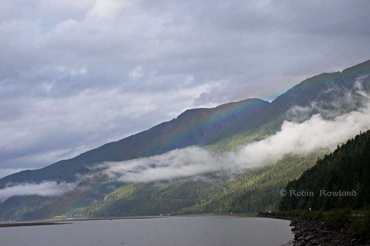
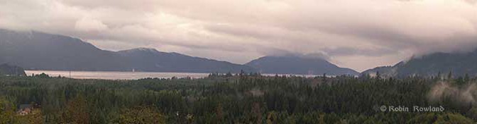
Clouds over Douglas Channel. (Robin Rowland/Northwest Coast Energy News)`
While the study is spun has a showing that industrial development in the Kitimat Valley can proceed as long as the environment is properly managed, the gaps and the spin will likely bring doubt to the results. That means that a wider ranging and truly independent study of the air shed is needed so that both residents and industry can then make the proper decisions.
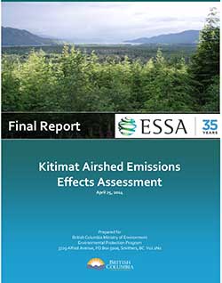
In October 2013, the Ministry of the Environment issues a “request for proposal” to “study potential cumulative effects to environment and human health from existing and proposed industrial facilities in the Kitimat airshed.” to be filed by March 31, 2014.
The Province will fund a $650,000 scientific study to help inform regulatory and policy development for future industrial activity in the Kitimat area. The goal is to ensure the potential impacts from industrial air emissions are clearly understood prior to new projects being approved and in operation.
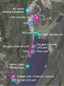
The Kitimat Airshed Impact Assessment Project will look at the cumulative effects of existing and proposed industrial air emissions in the airshed. These include emissions from: an existing aluminium smelter, three proposed LNG terminals, a proposed oil refinery, a crude-oil export facility, and gas-turbine-powered electrical generation facilities. The study will focus on sulphur dioxide and nitrogen dioxide emissions from these facilities.
The study will assess the impact of emissions through a number of scenarios, including their potential effects on water and soil, as well as on vegetation and human health from direct exposure.
With that news release, it appears that many people assumed that “cumulative effects of existing and proposed industrial air emissions in the air shed,” would include all possible scenarios and contaminants.
The report, when it was released on Friday, covered just the “focus” sulphur dioxide and nitrogen dioxide and no other factors in air quality.
Crude or refined oil export?
As Northwest Coast Energy News noted that the report, as released, doesn’t include any references to the Enbridge Northern Gateway project, even though Northern Gateway is a source of “proposed industrial air emissions in the air shed.” The request for proposal also mentions “a crude-oil export facility” but the report as issued concerns a marine terminal for Black’s refinery
The products will be exported via a marine terminal on the Douglas Channel. Projected volumes include 320,000 barrels per day of diesel fuel, 110,000 barrels per day of gasoline and 60,000 barrels per day of jet fuel.
The map in the main report clearly shows that the study concerned the “Kitimat Clean Refinery Port” not a crude oil export facility—in other words likely Enbridge Northern Gateway.
Kitimat excluded
On October 21, 2013, District of Kitimat Council endorsed a motion by former Councillor Corinne Scott:
“The BC Government has recently announced a budget of $650,000 to study the cumulative effects on the air quality due to the proposed industrial development in the District of Kitimat. It would be beneficial to have a representative from the District of Kitimat as an active participant on the committee to provide input and feedback as the study progresses.”
At the time Chief Adminstrative Officer Ron Poole told council that the minister’s office had called and promised to “involve the District.”
At that meeting, Councillor Mary Murphy reported that member were “vocal” at the Union of BC Municpalities that it was essential that Kitimat be involved. Councillors suggested that the study be wide ranging and include emissions already in the area and residual emissions left over from the closed Eurocan and Methaex operations.
The provincial final air shed report makes no mention at all of the District of Kitimat, Eurocan or Methanex.
In April, 2014, after the March 31, reporting deadine, the District and Council had heard nothing from the province. So in April, District Council passed a motion asking for a report on the status of the study.
Crown Privilege
In June, the province refused to release the report to lawyers involved in a suit against the Environmental Assessment Board which is challenging Rio Tinto Alcans’ permit to increase sulphur dixoide emission in the valley. According to the Globe and Mail, Dennis Doyle, a lawyer with the Ministry of the Attorney General, in the RTA suit, wrote to the Environmental Law Centre in Victoria
In a follow-up letter dated June 12, Mr. Doyle said, “On the matter of the Kitimat Airshed Study I am instructed that this report was prepared to guide development of government policy on industrial development in the Kitimat area and to assist the executive council in its ongoing deliberations. It is not a report that was prepared for the Respondent and played no part of the decision-making process for the permit amendment which is now under appeal.”
The EAB told the province to respond to that question by July 18. Instead there was a hastily called news conference and the report was released. However, a close look at the report shows that it was likely rushed to meet the EAB deadine and was incomplete—rather surprising for a report that was supposed to be complete by March 31.
Rushed report
What evidence is there that the report was rushed out by the Ministry of the Environment? The most compelling indication is that instead of a public-friendly Summary Report with an executive summary and clear conclusions, there was nothing more than a short Power Point presentation.
Most people in Kitimat who follow the energy debate are familiar with the approach of combining a readable summary with technical data. It is most evident in the report of the Enbridge Northern Gateway Joint Review, which issued a relative short summary, Connections along with the long technical report, Considerations.
Let’s take as a prime example, the original report on the Kitimat airshed commissioned by Rio Tinto Alcan. In that case, ESSA Technologies Ltd of Vancouver, the company hired by the RTA Kitimat Modernization Project to study the effects of increased sulphur dioxide emissions in the Kitimat Valley, issued three documents, an easy to understand 37-page summary report, a much longer 456 page Technical Assessment Report and a third 332 page volume of appendices, technical data and tables.
It was the same company, ESSA Technologies, that was retained by the province to do the much larger study of the airshed. However, the only public-friendly information was the 16 page highly simplified Power Point presentation.
The ESSA summary report for RTA shows in plain language, the reasons for its conclusions that the increased sulphur dioxide from KMP on human health “is characterized as moderate, an acceptable impact, but in need of closer scrutiny with moderate monitoring.” That report also outlines the limitations and uncertainties of the study.
There was no similar plain language summary released for the overall provincial air shed study, even though it was produced by the same company and came to similar conclusions. To find any limitations or uncertainties in the provincial air shed study you have to do a computer search for those key words.
So it is apparent that intended audience for the report is not really those who live in Kitimat, where over the past five years there is wide knowledge that a summary release along with a technical report is considered a standard procedure.
Kitimat not consulted
At the Friday news conference, reporters asked Environment Minister Mary Polak several times about the delay in releasing the report, and then why it was suddenly released.
In answer to the initial question, Polak said, “We had always intended to release it.” She refused to comment on the claim of cabinet privilege, saying that was the responsibility of government lawyers at the Ministry of the Attorney General. She said that the government had received the March 31 report “by the end of April and “it went through quite a rigorous and thorough review by different agencies… we are satisfied now that the findings have been given the kind of rigorous overview and we’re pleased with what has resulted from that.”
Polak said the Haisla Nation were consulted before the commissioning of the report.
Asked again about who the BC government consulted during the review period, she replied, “There were a number of other groups involved in technical review, so not just Ministry of Environment, you’ll be aware of Northern Health authority, but Ministry of Natural Gas Development, Health Canada, Environment Canada and also specialist reviewers from the Province of Quebec, the University of Helsinki, UBC, also private consultants. Then we spent some time going over and having a technical review with Gitga’at and Coastal Coastal First Nations. So it was a matter of ensuring that we had done the very best review of the work before the occasion on which we released it.”
Which leaves one big question, why was the Province of Quebec and the University of Helsinki consulted and Kitimat, despite requests, was not?
Not in the report, not my department
The provincial government called for a report on the “cumulative effects of existing and proposed industrial air emissions” and noted it would focus “ focus on sulphur dioxide and nitrogen dioxide emissions from these facilities.” It is clear that the report did not go beyond the narrow focus on those two substances.
At the Vancouver news conference, a reporter asked Polak why green house gases were not included.
She replied, “That’s not what this study was intended to look at. This department deals with pollutants and pollution and protecting our environment from it, whereas GHG [green house gas] emissions are dealt with in our department around climate change and climate action. These particular substances have an immediate impact on human health and vegetative health and the receiving environment generally unlike GHGs which are a more global impacted and of course have an impact on climate change. This study only looked at those pollutants sulphur doixide and nitrogen dioxide
Then a second reporter asked here about particulate matter, to which Polak replied, “Coming from the Fraser Valley I am very aware of the impact of particulate matter. Any industrial development that we permit in British Columbia or receives an environmental assessment certificate, particulate matter and the release of particulate matter is one of the things that gets evaluated as we determine whether or not to grant those permits. Or to put stipulations on those permits in order to ensure a reduction or management of particulate matter. That’s where that’s dealt with and we have some pretty good understanding of how that operates. We also have some modelling from this study.
“The reason this study didn’t report on that because we hadn’t asked them to. We specifically wanted to get at the issue of sulphur disoxide and nitrogen dioxide but please do not take frm that because it’s not in the study, it doesn’t get looked at. It simply gets looked at in a different process. In this case it was the understanding of the Kitimat air shed with respect to sulphur dixoide and nitrogen dioxide that we needed to have a better answers and better information.”
In other words, despite what the original proposal said: “The goal is to ensure the potential impacts from industrial air emissions are clearly understood prior to new projects being approved and in operation,” the provincial government is content to wait until the permit phase to consider particulate matter, rather than include particulate matter in the long term planning for the air shed.
And for green house gases, the same attitude seems to apply, either it’s not her department or it will be dealt with sometime in the future.
What’s going on in the air shed?
Although the provincial government has been able to spin that the air shed report clears the way for more industrial development in the region, the report isn’t much help for long term planning for those both for and against industrial development in the valley.
First one has to wonder just how comprehensive was the study, even when it comes to sulphur dioxide and nitrogen dioxide?
The report for Rio Tinto Alcan for just one substance—sulphur dixoide—from one industry—aluminum smelting–led to a 456 page technical report with 332 pages of appendices.
The provincial technical report adds one more substance, nitrogen dioxide, and adds four LNG facilities, an oil refinery, different export terminals for those industries, and two hydro generating stations plus related shipping, including a passing mention of vehicular and train traffic. The new report is 363 pages, including the appendices. (It should be noted that the air shed report does reference some of the information in the RTA report)
The various studies for the Enbridge Northern Gateway, which often contained material on air emissions, included a much longer list of what in industry jargon are called CPOC “chemicals of potential concern,” including chemicals that might be released in trace amounts from the Northern Gateway terminal, but may be of more concern from LNG projects. Who knows unless those substances are studied?
As was required by the Joint Review Panel, Enbridge also studied potential problems from accidental release of air-borne contaminants from the Northern Gateway project. There is no mention of accidental release in the current air shed study.
Although the increase in truck traffic in Kitimat is clearly visible to people who live in the town, the air shed report also speculates that with LNG and a possible refinery, there will also be a significant increase in rail traffic coming into Kitimat, hauled, of course, by diesel locomotives, which the report says is “expected to be conservatively captured within the background concentration adjustment.”
Can the Valley “handle industrial expansion”
Stakeholders in the region from the District of Kitimat to the Gitga’at First Nation to various environmental groups asked for a comprehensive review of what is going to happen in the Kitimat air shed with industrial expansion.
So the answer to the question can the valley “handle industrial expansion” after the flawed and limited report from the provincial government is not “yes,” but “we don’t know yet.”
It appears that the report is part of Christy Clark’s ongoing campaign that LNG will save the provincial economy.
There are two factors the report ignores.
First the energy companies are going to make their final investment decision on cold hard facts, including their own assessment of the potential problems from the air shed, not spin from the provincial government.
Second, until there is a proper air shed study, the First Nations, including the Haisla in Kitimat, the Gitga’at at Hartley Bay, the Kitselas in Terrace will not have solid evidence to make a decision on the details of the LNG or refinery development on their traditional territory and increased ship traffic along the coast and that will come into immediate conflict with the Supreme Court ruling on the Tsilhqot’in decision and the finding that “Whether a particular use is irreconcilable with the ability of succeeding generations to benefit from the land will be a matter to be determined when the issue arises.”
There is a new Orwellian phrase used by both the federal and provincial government. Every report is “independent” and “science-based,” although all they all tend to support the policy of the commissioning agency.
What the Kitimat Valley, Douglas Channel and the Terrace region need is a truly independent and truly science based and truly comprehensive evaluation of the air shed. At the moment, that doesn’t exist. It should whether it comes from industry or if the local governments can find the budget to fund a proper study or some combination of the two.
Councillor Phil Germuth listens as District of Kitimat Council debates his motion that would have required Enbridge to enhance monitoring of leaks on the pipeline in the Kitimat watershed. (Robin Rowland/Northwest Coast Energy News)
District of Kitimat Council voted Monday night to hold a plebiscite on whether or not the community supports the controversial Enbridge Northern Gateway project.
District council and staff will decide the actual question for voters and the date for the plebiscite in the coming couple of weeks.
A staff report described a plebiscite as “a non-binding form of referendum,” as defined by the BC Local Government Act.
The council decision comes after the Northern Gateway Joint Review Panel released its decision on December 16, that approved the pipeline and tanker project along with 209 conditions.
After the release of the Joint Review decision, the District of Kitimat issued a news release saying, “Kitimat Council has taken a neutral stance with respect to Northern Gateway. Council will take the necessary time to review the report in order to understand the content and reasons for the decision.”
On January 16, 2012 the council adopted a resolution “that after the completion of the JRP process, the District of Kitimat survey the residents of Kitimat regarding their opinion on the Enbridge Northern Gateway project.” After the JRP decision, the District reaffrimed that it would “undertake a survey of Kitimat residents to determine their opinions of the project now that the JRP has concluded its process.”
District staff had recommended hiring an independent polling firm to conduct the survey, pointing to a pollster’s ability to craft the appropriate questions and provide quick results.
Council quickly shot down the idea. A motion by Councillor Mario Feldhoff to use a polling firm did not get a seconder.
Councillor Rob Goffinet, who made the motion for the plebiscite, noted that even as a politician he doesn’t answer phone calls from unknown numbers. He said, “People do not want a pollster to phone them and do a check list how do you feel on a project. How can we be assured if someone in or out of their home will answer a call from a pollster? I would give total responsibility to every adult citizen of Kitimat who has a point of view to express it in a yes or no ballot.”
Councillor Phil Germuth added, “Those are the same companies that went out prior to the last provincial election and said one party was going to wipe it out and we know what happened there.” Germuth was referring to BC Premier Christy Clark’s come from behind majority victory which was not predicted in the polls.
Germuth told the meeting he believed an unbiased question could be posed in the form of a referendum on the Northern Gateway project. “I have full confidence in our staff that they will be able, along with some assistance from council, to develop questions that are not going to appear biased. It should be very simple, yes means yes, no means no.”
Councillor Mario Feldhoff, who earlier in the evening had, for the first time, declared that he is in favour of the Northern Gateway project, told council that he preferred using a polling firm because it could come back with a “statistically significant” result.
Council voted six to one in favour of the plebiscite. The lone dissenter was Councillor Edwin Empinado who told his colleagues that a mail-in ballot, another of the options presented by staff, would be more inclusive. Empinado said he was concerned that a plebiscite would mean a low voter turnout.
Warren Waycheshen, the district’s deputy chief administrative officer, told council that the plebiscite would have to be held under the provisions of BC’s Local Government Act which covers elections and referenda, but with the plebiscite the council would have more flexibility in deciding how the vote would take place. The act would still cover such things as who was eligible to vote and the use of campaign signs.
Councillor Mario Feldhoff reads a statement at council, supporting the findings of the Joint Review panel on the Northern Gateway project. (Robin Rowland/Northwest Coast Energy News)
The neutrality that council had maintained for at least the previous three years began to break down during Monday’s meeting meeting when Germuth proposed a motion that would have required Enbridge to install within Kitimat’s jurisdiction a detection system capable of locating small volumes of leakage from the pipeline, a measure that is likely beyond the recommendations of the JRP decision.
It was then that Feldhoff became the first Kitimat councillor to actually declare for or against the Northern Gateway, telling council, saying he agreed with the JRP, “The overall risk was manageable and the project was in Canada’s interest. On the whole I am in favour of the conditions and recommendations of the JRP… Not only am I a District of Kitimat Councillor, I am a Canadian. To my mind, opposition to the JRP Northern Gateway report at this stage is yet another case of NIMBY-ism, not in my backyard.”
In the end, at Feldhoff’s urging, the council modified the original motion, so that it called on the District to meet with Enbridge to discuss an enhanced pipeline leak detection system where a leak could “impact the Kitimat watershed.”
It’s not clear what Council will do with the result of the plebiscite, since it is “non-binding.”
In the past two years, Terrace, Prince Rupert and Smithers councils, together with Kitimat Stikine Regional District and the Skeena Queen Charlotte Regional District, all voted to oppose Northern Gateway. Those were all council votes, taken without surveying local opinion.
Most of the decisions are in the hands of the federal government which has 180 days from the release of the JRP report to approve the project.
A second floating liquified natural gas terminal may be planned for Kitimat, Northwest Coast Energy News has learned.
According to multiple sources in Kitimat, Altagas, the parent company of Pacific Northern Gas plans the terminal at the old log sort site on Douglas Channel, where the barge carrying the liquifaction equipment would likely be moored next door to the already planned BC LNG/Douglas Channel Partners LNG project which would be served by gas delivered by the PNG pipeline system.
Pacific Northern Gas has filed an application with the BC Environmental Assessment Office to construct and operate an approximately 525 kilometre, 610 millimetre (24 inch) diameter natural gas pipeline from the natural gas hub at Summit Lake, near Prince George, to Kitimat that would loop or twin the existing PNG existing natural gas pipeline.
The application to the BCEAO says: “The proposed Project would supply natural gas to proposed liquefied natural gas (LNG) export facilities as well as the Proponent’s existing customers. The proposed Project would include the replacement of four existing compressor stations and would have an initial capacity of 600 million standard cubic feet per day.”
PNG Pipeline Looping Project Open House at Tamitik. Nov. 26, 2013. (Robin Rowland/Northwest Coast Energy News)
On Tuesday, November 26, Pacific Northern Gas held a sparsely attended open house at Tamitik Arena as part of the BCEAO public comment procedure.
A 38 day public comment period on the application information requirements started on November 25 and will end on January 2, 2014.
At the open house, PNG officials explained that “looping” means that there would be a second or twin pipeline that would mostly be on a parallel route to the existing pipeline. Since both pipelines would begin at the Summit Lake terminal and end at the Kitimat terminal that is where the term “looping” comes in.
The PNG officials said that the pipeline was initially designed to service the first floating LNG terminal at the old log sort site on Douglas Channel south of Kitimat, but north of the KM LNG site at Bish Cove.
It would be operated by BC LNG Energy Cooperative, through Douglas Channel Energy Partnership, a partnership with the Haisla Nation and LNG Partners, the energy investors mainly from Texas,
Unlike the bigger project Kitimat LNG or KM LNG, a partnership between Chevron and Apache (and according to reports possibly Sinopec) or the Shell-led partnership LNG Canada, the BC LNG project would allow smaller companies to provide LNG to Asian customers.
At the open house, the PNG officials said the two pipelines could also service “another Kitimat floating LNG project” but declined to give details for confidentiality reasons. The same officials also said the proponent of that project was also looking at Prince Rupert as a possible site for the second floating terminal.
Kitimat sources have confirmed that AltaGas has told them that the company is also considering Prince Rupert as a site for a floating LNG terminal.
However, the current documentation and maps filed with the BCEAO show the PNG looping pipeline terminating at Kitimat, not Prince Rupert.
Detail of the PNG Pipeline Looping proposal. The existing pipeline is shown at the dashed line, the new pipeline is shown in purple. (PNG)
According to the maps filed with the BCEAO and made available at the open house, the new pipeline would not be twinned completely along the existing route across the mountains west of Smithers to Terrace, but would head north at Telkwa parallel to Highway 16 before making its own way through the mountains, crossing the existing pipeline at the Zymoetz River east of Terrace and then taking a westerly route toward Lakelese Lake before joining the existing pipeline corridor along Highway 37. AltaGas took over Pacific Northern Gas in the fall of 2011.
The problems currently faced by the Texas group have no affect, at this point, on the Haisla Nation investment in the BC LNG Energy Cooperative. There is already speculation in Kitimat that if the LNG Partners get into further financial difficulty, AltaGas may step in and take over. The would raise the question whether or not there would still be two floating LNG terminals on Douglas Channel, or just the one, as originally planned, but under new ownership.
In it’s project proposal PNG says
The Project will generate approximately 1800-2400 direct person years of employment during construction. Additionally, tax benefits will be generated for Kitimat and the regional districts crossed by the pipeline. PNG anticipates the project will also result in a significant reduction in natural gas transportation rates for its existing customers.
Natural gas transportation costs are a major issue in the northwest, for those costs appear to keep going up while the price of natural gas in North America is generally going down. Natural gas transportation costs in Kitimat spiked after the closure of the Methanex plant and have continued to be quite high, which is just one of the increasing burdens for residents of Kitimat on fixed or low incomes, who are not benefiting as others from the current boom town economy.
The PNG filing with the BCEAO promises consultation with both the Wet’suwet’en Council, and the Office of the Wet’suwet’en, which represents the hereditary chiefs and matriarchs, as well as other First Nations along the proposed route.
PNG Open houses for the project are scheduled for:
Vanderhoof
Friendship Centre Hall
Thursday, November 28, 2013
Terrace
Best Western Inn
Monday, December 2, 2013
Smithers
Hudson Bay Lodge
Tuesday, December 3, 2013
Burns Lake
Chamber of Commerce
Wednesday, December 4, 2013
Summit Lake
Community Hall
Thursday, December 5, 2013
The Panama registered bulk carrier Azuma Phoenix is seen tied up at Kitimat harbour on the afternoon of Jan 9, 2012. In March 2013. the federal government announced it was making the private port of Kitimat into a public port. (Robin Rowland)
When the story of the Stephen Harper government is told, historians will say that the week of March 17 to 23, 2013, is remembered, not for the release of a lacklustre federal budget, but for day after day of political blunders that undermined Harper’s goal of making a Canada what the Conservatives call a resource superpower.
It was a week where spin overcame substance and spun out of control.
The Conservative government’s aim was, apparently, to increase support for the Enbridge Northern Gateway pipeline project with a spin campaign aimed at moving the middle ground in British Columbia from anti-project to pro-project and at the same time launching a divide and conquer strategy aimed at BC and Alberta First Nations.
It all backfired. If on Monday, March 17, 2013, the troubled and controversial Enbridge Northern Gateway project was on the sick list, by Friday, March 23, the Enbridge pipeline and tanker scheme was added to the Do Not Resuscitate list, all thanks to political arrogance, blindfolded spin and bureaucratic incompetence. The standard boogeymen for conservative media in Canada (who always add the same sentence to their stories on the Northern Gateway) “First Nations and environmentalists who oppose the project” had nothing to do with it.
Stephen Harper has tight control of his party and the government, and in this case the billion bucks stop at the Prime Minister’s Office. He has only himself to blame.
All of this happened on the northern coast of British Columbia, far out of range of the radar of the national media and the Ottawa pundit class (most of whom, it must be admitted, were locked up in an old railway station in the nation’s capital, trying interpret Finance Minister Jim Flaherty’s spreadsheets).
The story begins early on that Monday morning, at my home base in Kitimat, BC, the proposed terminal for Northern Gateway, when a news release pops into my e-mail box, advising that Natural Resources Minister Joe Oliver would be in nearby Terrace early on Tuesday morning for an announcement and photo op.
I started making calls, trying to find out if anyone in Kitimat knew about Oliver’s visit to Terrace and if the minister planned to come to Kitimat.
Visitors to Kitimat
I made those calls because in the past two years, Kitimat has seen a parade of visitors checking out the town and the port’s industrial and transportation potential. The visitors range from members of the BC provincial Liberal cabinet to the staff of the Chinese consulate in Vancouver to top executives of some of the world’s major transnational corporations (and not just in the energy sector). Most of these visits, which usually include meetings with the District of Kitimat Council and District senior staff as well as separate meetings with the Council of the Haisla Nation, are usually considered confidential. There are no photo ops or news conferences. If the news of a visit is made public, (not all are), those visits are usually noted, after the fact, by Mayor Joanne Monaghan at the next public council meeting.
It was quickly clear from my calls that no one in an official capacity in Kitimat knew that, by the next morning, Oliver would be Terrace, 60 kilometres up Highway 37. No meetings in Kitimat, on or off the record, were scheduled with the Minister of Natural Resources who has been talking about Kitimat ever since he was appointed to the Harper cabinet.
I was skeptical about that afternoon’s announcement/photo op in Vancouver by Transport Minister Denis Lebel and Oliver about the “world class” tanker monitoring.
After all, there had been Canadian Coast Guard cutbacks on the northwest coast even before Stephen Harper got his majority government. The inadequacy of oil spill response on the British Columbia coast had been condemned both by former Auditor General Sheila Fraser and in the United States Senate. The government stubbornly closed and dismantled the Kitsilano Coast Guard station. It’s proposing that ocean traffic control for the Port of Vancouver be done remotely from Victoria, with fixed cameras dotted around the harbour. Leaving controllers in Vancouver would, of course, be the best solution, but they must be sacrificed (along with any ship that get’s into trouble in the future, on the altar of a balanced budget).
The part of the announcement that said there would be increased air surveillance is nothing more than a joke (or spin intended just for the Conservative base in Alberta, Saskatchewan and the Toronto suburbs,that is not anyone familiar with BC coastal waters). Currently the Transport Canada surveillance aircraft are used on the coasts to look for vessels that are illegally dumping bilge or oil off shore. As CBC’s Paul Hunter reported in 2010, Transport Canada aircraft were used after the Gulf of Mexico oil disaster to map where the oil was going after it erupted from the Deepwater Horizon.
Given the stormy weather on the west coast (when Coast Guard radio frequently warns of “hurricane force winds”) it is highly unlikely that the surveillance aircraft would even be flying in the conditions that could cause a major tanker disaster. Aerial surveillance, even in good weather, will never prevent a tanker disaster caused by human error.
I got my first chance to look at the Transport Canada website in late afternoon and that’s when a seemingly innocuous section made me sit up and say “what is going on?” (I actually said something much stronger).
Public port
Public port designations: More ports will be designated for traffic control measures, starting with Kitimat.
(Transport Canada actually spelled the name wrong—it has since been fixed—as you can see in this screen grab).
Kitimat has been one of the few private ports in Canada since the Alcan smelter was built and the town founded 60 years ago (the 60th anniversary of the incorporation of the District of Kitimat is March 31, 2013).
The reasons for the designation of Kitimat as a private port go back to a complicated deal between the province of British Columbia and Alcan in the late 1940s as the two were negotiating about electrical power, the aluminum smelter, the building of the town and the harbour.
For 60 years, Alcan, later Rio Tinto Alcan, built, paid for and operated the port as a private sector venture. For a time, additional docks were also operated by Eurocan and Methanex. After Eurocan closed its Kitimat operation that dock was purchased by the parent company Rio Tinto. The Methanex dock was purchased by Royal Dutch Shell last year for its proposed LNG operation.
The announcement that Kitimat was to become a public port was also something that the national media would not recognize as significant unless they are familiar with the history of the port. That history is known only to current and former residents of Kitimat and managers at Rio Tinto Alcan.
The port announcement came so much out of left field; so to speak, that I had doubts it was accurate. In other words, I couldn’t believe it. I went to Monday evening’s meeting of District of Kitimat Council and at the break between the open and in-camera sessions, I asked council members if they had heard about Kitimat being redesignated a public port. The members of the district council were as surprised as I had been.
Back from the council meeting, I checked the Transport Canada news release and backgrounders. I also checked the online version of Bill C-57, the enabling act for the changes announced earlier that day. There was no mention of Kitimat in Bill C-57.
Tuesday morning I drove to Terrace for Joe Oliver’s 9 am photo op and the announcement at Northwest Community College (NWCC) that the government had appointed Douglas Eyford as a special envoy to First Nations for energy projects, an attempt on the surface to try and get First Nations onside for the pipeline projects, an appointment seen by some First Nations leaders as an attempt by the Harper government to divide and conquer.
As an on site reporter, I got to ask Oliver two questions before the news conference went to the national media on the phones.
In answer to my first question, Oliver confirmed that the federal government had decided to make Kitimat a public port, saying in his first sentence: “What the purpose is to make sure that the absolute highest standards of marine safety apply in the port of Kitimat.” He then returned to message track saying, “we have as I announced yesterday and I had spoken about before at the port of Vancouver we have an extremely robust marine safety regime in place but we want to make sure that as resource development continues and as technology improves, we are at the world class level. As I also mentioned there has never been off the coast of British Columbia a major tanker spill and we want to keep that perfect record.”
For my second question, I asked Oliver if he planned to visit Kitimat.
He replied. “Not in this particular visit, I have to get back [to Ottawa] There’s a budget coming and I have to be in the House for that but I certainly expect to be going up there.”
The question may not have registered with the national media on the conference call. For the local reporters and leaders in the room at Waap Galts’ap, the long house at Terrace’s Northwest Community College, everyone knew that Kitimat had been snubbed.
Back in Kitimat, I sent an e-mail to Colleen Nyce, the local spokesperson for Rio Tinto Alcan noting that Joe Oliver had confirmed that the federal government intended to make the RTA-run port a public port. I asked if RTA had been consulted and if the company had any comment.
Nyce replied that she was not aware of the announcement and promised to “look into this on our end.” I am now told by sources that it is believed that my inquiry to Nyce was the first time Rio Tinto Alcan, one of Canada’s biggest resource companies, had heard that the federal government was taking over its port.
The next day, Kitimat Mayor Joanne Monaghan told local TV news on CFTK the Kitimat community was never consulted about the decision and she added that she still hadn’t been able to get anyone with the federal government to tell her more about the plan.
Who pays for the navigation aids?
Meanwhile, new questions were being raised in Kitimat about two other parts of the Monday announcement.
New and modified aids to navigation: The CCG will ensure that a system of aids to navigation comprised of buoys, lights and other devices to warn of obstructions and to mark the location of preferred shipping routes is installed and maintained. Modern navigation system: The CCG will develop options for enhancing Canada’s current navigation system (e.g. aids to navigation, hydrographic charts, etc) by fall 2013 for government consideration.
Since its first public meeting in Kitimat, in documents filed with the Northern Gateway Joint Review Panel, in public statements and advertising, Enbridge has been saying for at least the past four years that the company would pay for all the needed upgrades to aids to navigation on Douglas Channel, Wright Sound and other areas for its tanker traffic. It is estimated that those navigation upgrades would cost millions of dollars.
Now days before a federal budget that Jim Flaherty had already telegraphed as emphasizing restraint, it appeared that the Harper government, in its desperation to get approval for energy exports, was going to take over funding for the navigation upgrades from the private sector and hand the bill to the Canadian taxpayer.
RTA not consulted
On Thursday morning, I received an e-mail from Colleen Nyce with a Rio Tinto Alcan statement, noting:
This announcement was not discussed with Rio Tinto Alcan in advance. We are endeavoring to have meetings with the federal government to gain clarity on this announcement as it specifically relates to our operations in Kitimat.
On Friday morning, Mayor Monaghan told Andrew Kurjata on CBC’s Daybreak North that she had had at that time no response to phone calls and e-mails asking for clarification of the announcement. Monaghan also told CBC that Kitimat’s development officer Rose Klukas had tried to “get an audience with minister and had been unable to.” (One reason may be that Oliver’s staff was busy. They ordered NWCC staff to rearrange the usual layout of the chairs at Waap Galts’ap, the long house, to get a better background for the TV cameras for Oliver’s statement).
Natural Resources Minister Joe Oliver (front far right) answers questions after his news conference at the Northwest Community College Long House, March 19, 2013. (Robin Rowland)
Monaghan told Kurjata, “I feel like it’s a slap in the face because we’re always being told that we’re the instrument for the whole world right now because Kitimat is supposed to be the capital of the economy right now. So I thought we’d have a little more clout by now and they’d at least tell us they were going to do this. There was absolutely no consultation whatsoever.”
By Friday afternoon, five days after the announcement, Transport Canada officials finally returned the calls from Mayor Monaghan and Rose Klukas promising to consult Kitimat officials in the future.
Monaghan said that Transport Canada told her that it would take at least one year because the change from a private port to a public port requires a change in legislation.
Transport Canada is now promising “extensive public and stakeholder consultation will occur before the legislation is changed,” the mayor was told.
On this Mayor Monaghan commented, “It seems to me that now they want to do consultation….sort of like closing the barn door after all of the cows got out!”
Blunder No 1. Pulling the rug out from Northern Gateway
Joe Oliver and the Harper government sent a strong political signal to Kitimat on Tuesday; (to paraphrase an old movie) your little town doesn’t amount of a hill of beans in this crazy world.
There are a tiny handful of people in Kitimat openly in favour of the Northern Gateway project. A significant minority are on the fence and some perhaps leaning toward acceptance of the project. There is strong opposition and many with a wait and see attitude. (Those in favour will usually only speak on background, and then when you talk to them most of those “in favour” have lists of conditions. If BC Premier Christy Clark has five conditions, many of these people have a dozen or more).
Oliver was speaking in Terrace, 60 kilometres from Kitimat. It is about a 40 to 45 minute drive to Kitimat over a beautiful stretch of highway, with views of lakes, rivers and mountains.
Scenic Highway 37 is the route to the main location not only for the controversial Northern Gateway pipeline but three liquefied natural gas projects, not to mention David Black’s proposed refinery half way between Terrace and Kitimat.
Why wouldn’t Kitimat be a must stop on the schedule for the Minister of Natural Resources? In Terrace, Oliver declared that Kitimat was to become a public port, run by the federal government. Although technically that would be the responsibility of Denis Lebel, the Minister of Transport, one has to wonder why the Minister of Natural Resources would not want to see the port that is supposedly vital to Canada’s economy? You have to ask why he didn’t want to meet the representatives of the Haisla Nation, the staff and council of the District of Kitimat and local business leaders?
Oliver has been going across Canada, the United States and to foreign countries promoting pipelines and tanker traffic, pipelines that would terminate at Kitimat and tankers that would send either bitumen or liquefied natural gas to customers in Asia.
Yet the Minister of Natural Resources is too important, too busy to take a few hours out of his schedule, while he is in the region, to actually visit the town he has been talking about for years.
He told me that he had to be in Ottawa for the budget. Really? The budget is always the finance minister’s show and tell (with a little help from whomever the Prime Minister is at the time). On budget day, Oliver would have been nothing more than a background extra whenever the television cameras “dipped in” on the House of Commons, between stories from reporters and experts who had been in the budget lockup.
According to the time code on my video camera, Oliver’s news conference wrapped at 9:50 a.m., which certainly gave the minister and his staff plenty of time to drive to Kitimat, meet with the representatives of the District, the Haisla Nation and the Chamber of Commerce and still get to Vancouver for a late flight back to Ontario.
On Tuesday, Joe Oliver’s snub pulled the political rug out from under the Northern Gateway supporters and fence sitters in Kitimat. Oliver’s snub showed those few people in Kitimat that if they do go out on a limb to support the Northern Gateway project, the Conservatives would saw off that limb so it can be used as a good background prop for a photo op.
Prince Rupert, Terrace and Smithers councils have all voted against the Northern Gateway project. Kitimat Council, despite some clear divisions, has maintained a position of absolute neutrality. Kitimat Council will continue to be officially neutral until after the Joint Review report, but this week you could hear the air slowly leaking out of the neutrality balloon.
Oliver may still believe, as he has frequently said, that the only people who oppose Northern Gateway are dangerous radicals paid by foreign foundations.
What he did on Tuesday was to make the opposition to Northern Gateway in Kitimat into an even more solid majority across the political spectrum.
Blunder No 2. Rio Tinto Alcan
It doesn’t do much for the credibility of a minister of natural resources to thoroughly piss off, for no good reason, the world’s second largest mining and smelting conglomerate, Rio Tinto. But that’s just what Joe Oliver did this week.
I am not one to usually have much sympathy with rich, giant, transnational corporations.
But look at this way, over the past 60 years Alcan and now Rio Tinto Alcan have invested millions upon millions of dollars in building and maintaining the Kitimat smelter and the port of Kitimat. RTA is now completing the $3.3 billion Kitimat Modernization Project. Then without notice, or consultation, the Conservative government—the Conservative government—announces it is going to take over RTA’s port operations. What’s more, if what Transport Canada told Mayor Joanne Monaghan is correct, the federal government is going to start charging RTA fees to use the port it has built and operated for 60 years.
Too often RTA’s London headquarters acts like it is still the nineteenth century and the senior executives are like British colonialists dictating to the far reaches of the Empire on what do to do.
No matter what you think of RTA, it boggles the mind, whether you are right wing, left wing or mushy middle, that the federal government simply issues a press release–a press release– with not even a phone call, not even a visit (even to corporate headquarters) saying “Hey RTA, we’re taking over.”
There’s one thing that you can be sure of, Rio Tinto Alcan’s lobbyists are going to be earning their fees in the coming weeks.
(One more point, even if there wasn’t a single pipeline project planned for Kitimat you would think that the Minister of Natural Resources would want to see what is currently the largest and most expensive construction project in Canada, a project that comes under his area of political responsibility).
It took five days, from the time of the minister’s news conference on Monday until Friday afternoon, for officials in Transport Canada to return phone calls from Mayor Joanne Monaghan and Rose Klukas, to explain what was going to happen to the Port of Kitimat.
This week was yet another example of the decay of Canadian democracy under Stephen Harper. Executives from Tokyo to Houston to the City of London quickly return phone calls from the District of Kitimat, after all Kitimat is where the economic action is supposed to be. At the same time, the federal government doesn’t return those calls, it shows that something really is rotten in our state.
Blunder No 5. LNG
There are three liquefied natural gas projects slated for Kitimat harbour, the Chevron-Apache partnership in KM LNG, now under construction at Bish Cove; the Royal Dutch Shell project based on the old Methanex site and the barge based BC LNG partnership that will work out of North Cove.
None of these projects have had the final go ahead from the respective company board of directors. So has the federal government thrown the proverbial monkey wrench into these projects? Will making Kitimat a public port to promote Enbridge, help or hinder the LNG projects? Did the Ministry of Natural Resources even consider the LNG projects when they made the decision along with Transport Canada to take over the port?
And then there’s…..
Kitimat has a marina shortage, especially since RTA closed the Moon Bay Marina. The only one left, the MK Bay Marina, which is straining from overcapacity, is owned by the Kitimat-Stikine Regional District. That means there will be another level of government in any talks and decisions on the future of the Kitimat harbour. There are also the controversial raw log exports from nearby Minette Bay.
Although Transport Canada has promised “extensive public and stakeholder consultation,” one has to wonder how much input will be allowed for the residents of Kitimat and region, especially the guiding and tourism industries as well as recreational boaters. After all, the Harper government is determined to make Kitimat an export port for Alberta and the experience of the past couple of years has shown that people of northwest count for little in that process. Just look at the Northern Gateway Joint Review, which more and more people here say has no credibility.
Big blunder or more of the same?
I’ve listed five big blunders that are the result of the decision by the Harper government to turn Kitimat into a public port.
Are they really blunders or just more of the same policies we’ve seen from Stephen Harper since he became a majority prime minister?
This is a government that has muzzled scientific research and the exchange of scientific ideas. The minister who was in the northwest last week, who has demonized respect for the environment, is now squeezing the words “science” and “environment” anywhere into any message track or speech anyway he can.
That’s just the point. Joe Oliver’s fly-in, fly-out trip to Terrace was not supposed to have any substance. Changing the chairs at the Waap Galts’ap long house showed that it was more important to the Harper government to have some northwest coast wall art behind Joe Oliver for his photo op than it was to engage meaningfully with the northwest, including major corporations, First Nations and local civic and business leaders.
Joe Oliver’s visit to Terrace was an example of government by reality television. The decision to change the private port of Kitimat into a public port was another example of Harper’s government by decree without consulting a single stakeholder. The problem is, of course, that for decades to come, it will be everyone in northwest British Columbia who will be paying for those 30 second sound bites I recorded on Tuesday.
Epilogue: Alcan’s legacy for the socialist Prime Minister, Stephen Harper
If an NDP or Liberal government had done what Harper and Oliver did on Monday, every conservative MP, every conservative pundit, every conservative media outlet in Canada would be hoarse from screaming about the danger from the socialists to the Canadian economy.
That brings us to the legacy left by R. E. Powell who was president of Alcan in the 1940s and 50s as the company was building the Kitimat project.
As Global Mission, the company’s official history, relates, in 1951, Alcan signed an agreement with the British Columbia provincial government, that “called upon the company to risk a huge investment, without any government subsidy or financial backing and without any assured market for its product.”
According to the book, Powell sought to anticipate any future problems, given the tenor of the times, the possible or even likely nationalization of the smelter and the hydro-electric project.
So Powell insisted that the contract signed between Alcan and the province include preliminary clauses acknowledging that Alcan was paying for Kitimat without a single cent from the government:
Whereas the government is unwilling to provide and risk the very large amounts of money required to develop those water powers to produce power for which no market now exists or can be foreseen except through the construction of the facilities for the production of aluminum in the vicinity and….
Whereas the construction of the aluminum plant at or near the site of the said waterpower would accomplish without risk or to the GOVERNMENT the development power, the establishment of a permanent industry and the new of population and….
(Government in all caps in the original)
…the parties hereto agree as follows (the agreement, water licence and land permit)
Powell is quoted in the book as saying:
I asked the political leaders of BC if the government would develop the power and sell the energy to Alcan and they refused. We had to do it ourselves. Someday, perhaps, some politician will try to nationalize that power and grab it for the state. I will be dead and gone but some of you or your successors at Alcan may be here, and I hope the clauses in the agreement, approved by the solemn vote of the BC legislature, will give those future socialists good reason to pause and reflect.
In the late 1940s and early 1950s, the federal government had very little to do with the Kitimat project. With the declaration that Kitimat will be a public port, the federal government comes to the party 60 years late. But one has to wonder if the late Alcan president, R.E. Powell, ever considered that the “future socialists” he hoped would “pause and reflect” would be members of Canada’s Conservative party, Stephen Harper, Joe Oliver and Denis Lebel?
 As related in Gordon Robinson’s Tales of the Kitamaat, the First Peoples living on the coast of what is now British Columbia ventured up what is now called Douglas Channel perhaps from either Bella Bella in Heiltsuk traditional territory or from Prince Rupert in Tsimshian traditional territory.