There’s a dumb, dumb, really dumb idea that just won’t go away—that Enbridge could solve all its problems if only, if only, it would send the Northern Gateway Pipeline to Prince Rupert.
Enbridge long ago rejected the idea. Before Enbridge updated its website to make Gateway Facts, to make it slick and more attractive, the old website had an FAQ where Enbridge explained why it wasn’t going to Prince Rupert.
Did you consider running the pipeline to Prince Rupert where a major port already exists?
We considered Prince Rupert and Kitimat as possible locations. We carried out a feasibility study that took into account a number of considerations. The study found that the routes to Prince Rupert were too steep to safely run the pipeline, and that Kitimat was the best and safest option available.
Current proposed route for the Northern Gateway pipeline. (Enbridge)
Here in the northwest even the supporters of the Northern Gateway roll their eyes when they hear the old Prince Rupert story come up again and again – and it’s not just because these people support the Kitimat plans for Northern Gateway, it’s because those supporters (not to mention the opponents) have driven along the Skeena from Terrace to Prince Rupert.
There just isn’t any room for a pipeline. It’s a game of centimetres.
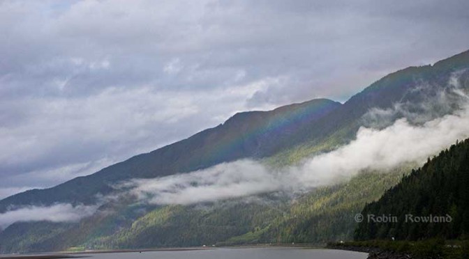
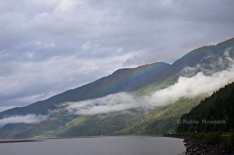
A rainbow hugs the mountains near the Telegraph Point rest area on the Skeena River between Terrace and Prince Rupert, Sept. 29, 2014. Traffic is seen on the narrow corridor between the mountains and the river (Robin Rowland/Northwest Coast Energy News)
Alternatives to Kitimat?
Now the new premier of Alberta, Jim Prentice, who should know better if he’s going to lead that province, is hinting that Kitimat isn’t the only possible solution for the Northern Gateway.
Without specifying Prince Rupert, according to Gary Mason reporting in The Globe and Mail, Prentice was speculating about an alternative to Kitimat.
Asked whether he believes the Gateway terminus should be relocated to Prince Rupert or another destination, Mr. Prentice said, “Everything I’ve heard from the Haisla who live there is they don’t agree with the terminal being in Kitimat.” Is it possible to get First Nations approval if there is no support at the planned terminus site? “It’s pretty tough,” the Premier said.
Prince Rupert has a thriving local fishing industry that employs hundreds of people and is critically important to the local First Nations. He is convinced the community would not be willing to put that at risk.
“Overwhelmingly people in my community are much more comfortable with liquefied natural gas, with wood pellets, with coal, than any oil product,” he said.
The Prince Rupert Port Authority also rejected the idea
A spokesman for the Prince Rupert Port Authority said Wednesday there is currently no room for Enbridge to build at the port even if it wanted to. “We are fully subscribed,” Michael Gurney said. There are two large vacant lots within the port authority’s jurisdiction, but both are locked by other energy companies, earmarked for LNG projects.
So not only is there no room on the road to Prince Rupert, there is no room in Prince Rupert.
Shovel-ready?
Let’s just consider for a moment that if Prince Rupert was the ideal location for the Northern Gateway terminal (which it is not), what would be needed to get the project going today.
The Northern Gateway Joint Review Panel would have be reconstituted or a new JRP created by the National Energy Board. That’s because the bitumen comes from Bruderheim, Alberta, crossing provincial boundaries and thus it’s in federal jurisdiction.
Even under the fast track rules imposed on the NEB by Stephen Harper’s Conservative government, new environmental and social impact studies would be required, starting from scratch. So add another five years of paperwork before a single shovel goes into the ground.
The pipeline would have to cross the traditional territory of First Nations that, so far, have not been part of the negotiations, mostly the Tsimshian First Nation as well as the Nisga’a First Nation which has a treaty establishing local rule over their territory.
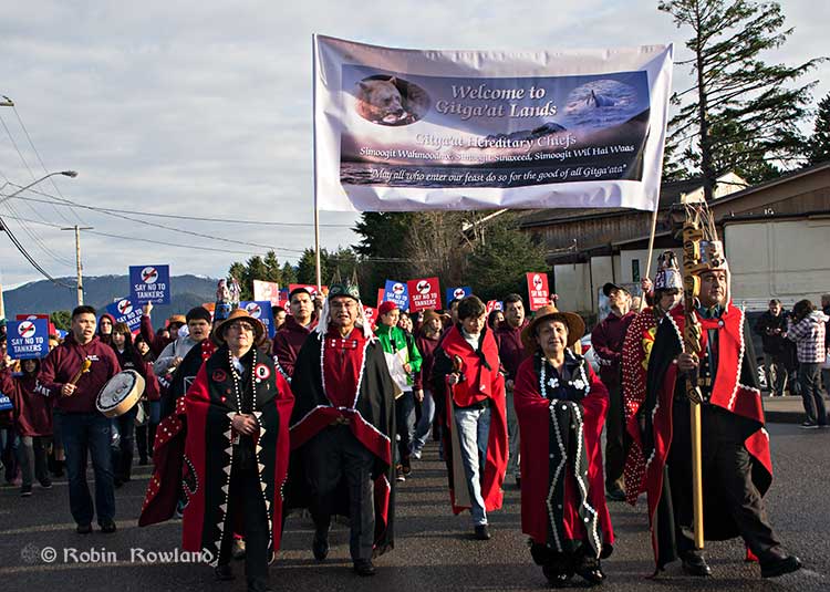
Traditional leaders of the Gitga’at First Nation lead a protest march through the streets of Prince Rupert, February 4, 2012. (Robin Rowland/Northwest Coast Energy News)
In February 2012, the largest anti-Enbridge demonstration outside of the Lower Mainland took place in Prince Rupert, with the elders of the Tsimshian First Nation welcoming the elders and members of the Gitga’at First Nation, at Hartley Bay, which had organized the protest.
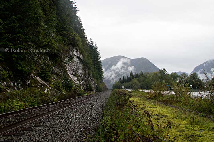
When I say there isn’t room for a pipeline along the Skeena, it also means that there isn’t any room for the pipeline corridor right-of-way. Enbridge, in its submissions to the Joint Review Panel, said it requires a 25 metre wide right of way for the pipeline corridor. (For the record that’s just over 82 feet).
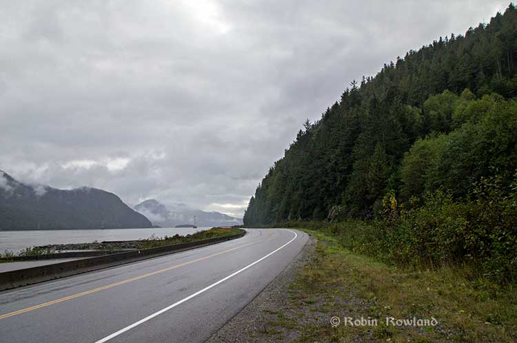
Along that highway, as you will see, there’s barely enough room for the CN mainline and Highway 16 (also known as the Yellowhead Highway) and on a lot of places both the highway and the railway roadbed are built on fill along the side of a cliff.
Albertans’ desperate desire to see the Northern Gateway go to anywhere to what they call “tide water” keeps coming up like the proverbial bad penny. The latest came when Jim Prentice speculated about a new route for the Northern Gateway.
I knew I had an appointment coming up in Prince Rupert on Monday, September 29. So I decided that only way to prove to people sitting in Calgary, Edmonton and Fort McMurray playing with Google Maps that the pipeline to Prince Rupert was a really dumb idea was to shoot photographs to show just why the Northern Gateway will never go to Prince Rupert—at least along the Skeena.
As you drive out of Terrace, you pass two large swing gates (also called by some “Checkpoint Charlie” gates after the Cold War era crossing in Berlin.) At the first rest stop west of Terrace, there are another set of gates at the Exstew. There’s a third set of gates just outside Prince Rupert.
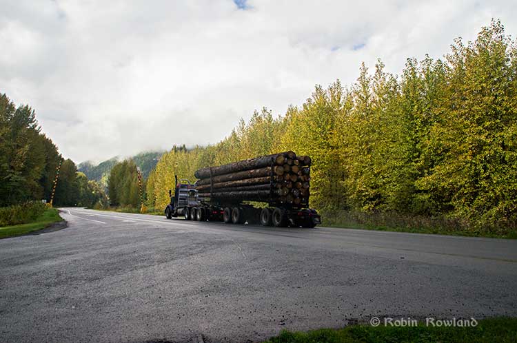
A logging truck passes the avalanche gates at Exstew on Highway 16, Sept. 29, 2014. (Robin Rowland)
The swing gates are avalanche gates and, in the winter, Highway 16 can be shut down if an avalanche closes the highway or the danger from avalanche is too great to allow motorists to proceed. When you drive the highway from Terrace to Prince Rupert in the winter (the signs were covered up when I drove Monday) you are warned “Avalanche danger Next 13 kilometres. No stopping.”
The Exstew avalanche gates, (Robin Rowland/Northwest Coast Energy News)
The drive along the Skeena from just west of Exchamsiks River Provincial Park all the way to Tyee where the highway turns inland to reach northwest to Prince Rupert on Kaien Island is one of the most spectacular drives on this planet. The highway snakes along a narrow strip of land with steep mountain cliffs on one side and the vast river on the other.
The problem is that apart from locals and tourists, none of the “experts” whether journalist, think tanker, bureaucrat or politician have, apparently ever driven from Prince Rupert to Terrace.
When both Opposition Leader Tom Mulcair and Liberal Leader Justin Trudeau were in the northwest earlier this summer to “engage” with the local people, apart from short boat trips down Douglas Channel, they flew everywhere. Scheduling you know. Stephen Harper has never visited northwest BC and probably never intends to. His cabinet members fly in for photo ops and then are on the next plane out of town.
Of all the visiting journalists who have come to the northwest only a couple have bothered to drive around the region. Most fly-in fly-out. These days, most often budget-strapped reporters never leave their offices, interviewing the same usual suspects by phone on every story.
On Monday, I took most of the photographs on my way back from Prince Rupert to Terrace after my appointment, so the sequence is from west to east. There are also very few places along the river where you can safely stop. There are concrete barricades on both sides of the highway to prevent vehicles either going into the river or onto the narrow CN right-of-way.
There are, however, two rest stops and a number of small turnoffs on the highway, the turnoffs mainly intended for use by BC Highways, but which are also used by tourists, fishers and photographers.
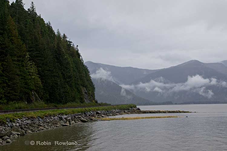
The first image was taken at one of those highway turnoffs just east of Aberdeen Creek. This is what the highway and rail corridor are like all along the Skeena, the highway, bounded by concrete barricades, the CN rail line and then the towering mountains. Note where the telegraph and telephone lines are—further up the cliffside.
A closer view of the highway and rail corridor just east of Aberdeen Creek.
Here is the view of the Skeena River from the Aberdeen Creek turnoff. You can see to the east, a mountain and the narrow strip of fill land that supports the highway and the rail line.
You see the broad width of the mighty Skeena, the Misty River, as it is called by the Tsimshian First Nation and by everyone else who lives in the northwest and on the right side of the image, the highway and rail corridor built on fill.
Any room for a pipeline?
There’s another turnoff on the other side of the headland east of Aberdeen Creek, looking back the way we came.
The final small turnoff is just by the Kylex River. Again you can see how narrow the highway and rail corridor are.
A few kilometres further along—as I said the highway snakes and curves its way along the riverbank– you come to the Basalt Creek rest area. So this telephoto image shows a logging truck heading west, taken from Basalt Creek, looking back at the highway.
Again you can see both the highway and CN line are built on fill. Is there any room for a pipeline?
Any room for a 25 metre pipeline right-of-way?
Between Basalt Creek and Telegraph Point, a few kilometres to the east, again the highway and rail line hug the narrow strip between the river and mountains.
This shot, taken from Telegraph Point, in October 2013, shows a CN intermodal container train heading to Prince Rupert. The container trains and the coal trains usually have between 150 and 180 cars. If a winter avalanche took out a train, there would be environmental damage, but that damage would be insignificant from coal or containers compared to a train of railbit tankers carrying diluted bitumen.
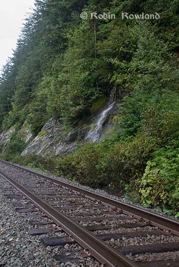
At Telegraph Point, the second of the three rest stops between Prince Rupert and Terrace, again there is just a narrow strip between the mountain, the highway and the river.
Across the highway from the rest stop, you can again see the narrow corridor, the first shot looking west the rail line close to the cliff face, the second, east, with the waterfall, which you don’t see during the rest of the year, fed by the fall monsoon.
Two shots from the same location, Telegraph Point, taken in March, 2013, of a CN locomotive hauling empty coal cars back to the fields around Tumbler Ridge. (No waterfall in March)
Alternative routes
Everyone has assumed that if Northern Gateway changed its route, the most likely choice given the configuration of the pipeline at the moment is to follow the Skeena.
There are alternatives. The Petronas LNG project and its partner TransCanada Pipelines have proposed a more northern cross-country route, which would go north from the Hazeltons, avoiding the Skeena
If Enbridge wanted to try a northern route, similar to the one TransCanada contemplates for Petronas, Northern Gateway would again run into trouble.
It would require reopening or creating a new Joint Review Panel, many more years of environmental and social impact studies of the route, even under Stephen Harper’s fast track system. The TransCanada/Petronas pipeline would also cross the traditional territory of the Gitxsan First Nation and if Enbridge tried that the company would have to deal with the fact that it signed a controversial agreement with Elmer Derrick that was immediately repudiated by most members of the Gitxsan First Nation and eventually dropped by Enbridge.
So why does this idea of a pipeline to Prince Rupert keep coming up?
In most cases, the idea of the pipeline to Prince Rupert is always proposed by Albertans, not from any credible source in British Columbia, or the suggestions come from desk bound analysts in Toronto and Ottawa both in think tanks and in the newsrooms of dying newspapers who have never seen the Skeena River apart from a tiny handful who have looked at Google Street View
(Yes you can Google Street View Highway 16 along the Skeena, I recommend it if you can’t do the drive)
Perhaps the worst example of this failure of both analysis and journalism came in the Edmonton Journal on July 7,2014, when it published a piece by Bob Russell, entitled Opinion: Make Prince Rupert the terminus, which went over the same old inaccurate arguments.
The overland route currently proposed by Enbridge is fraught with environmental issues because it goes over coastal mountains and streams before entering Kitimat’s port. This port will also be the base of perhaps as many as four liquefied natural gas terminals, which will result in the channel always busy with LNG ships outbound and returning from many Asian ports.
There are existing rights of way for the major highway, the Yellowhead, and CN Rail line from Edmonton to the Port of Prince Rupert, so this eliminates the issue of transgressing First Nations lands. The technical issues of narrow passages can be overcome with engineering. In fact, the pipeline can be buried in the roadway at some restricted locations if absolutely necessary, but two different engineers have assured me that for the most part, the right of way should be able to handle the pipeline. A vital factor, of course, is to reduce the impact by eliminating the need for two pipelines.
The clue is how the Edmonton Journal describes Russell;
Bob Russell has an extensive background in planning and was a member of the Edmonton Metro Regional Planning Commission. He has flown the Douglas Channel, visited Kitimat and toured the Port of Prince Rupert.
This is so typical of the Albertan attitude toward northwest British Columbia, people fly in for a couple of days, make a quick observation, and fly out again and present themselves as experts on the region. (Some “experts” on Kitimat, very active on Twitter have apparently never left Calgary).
It obvious that the “two engineers” who assured him “the right-of-way could handle of pipeline” have no idea what they’re talking about. As the photos show there is barely enough room for a highway and a rail line much less a 25 metre wide pipeline corridor.
If the pipeline was to be built as Russell proposed, the only highway between Prince Rupert and the rest of Canada would have to be closed for years, there are no detours. All so a pipeline can be buried under the asphalt not in solid ground, but in the fill on the side of a riverbank in an avalanche zone?
Of course, closing a highway up here won’t inconvenience anyone in Edmonton or Calgary, will it?
Would CN be happy with years of disruption of their lucrative traffic to Prince Rupert with grain and coal outbound to Asia and all those containers coming in to feed Chinese products to the North American market? (you can be sure Walmart wouldn’t be happy about that, not to mention prairie farmers including those from Alberta)
Russell’s statement
There are existing rights of way for the major highway, the Yellowhead, and CN Rail line from Edmonton to the Port of Prince Rupert, so this eliminates the issue of transgressing First Nations lands.
Is also inaccurate.
I was told by First Nations leaders during the Idle No More demonstrations in the winter of 2013, that, a century ago, when the Grand Trunk built the railway along the Skeena , they did just that, built it without consulting the First Nations along the route, sometime digging up native cemeteries and sacred spots.
While apparently CN has worked in recent years to improve relations with the First Nations along the rail line, according to those leaders some issues of right-of-way remain to be resolved.
If there were any plans to build a diluted bitumen pipeline along that route, that would likely mean another court battle adding to those already before the Federal Court, a court battle that would cost Enbridge, CN, the federal government, environmental NGOs and the First Nations more millions in lawyers’ fees.
It’s doubtful if in the long gone (and perhaps mythical) days of “get it right” journalism that the Russell opinion piece would have passed the scrutiny of an old fashioned copy editor and fact checker.
In 2012, the Edmonton Journal (in a story no longer available on their website) also cited former Alberta Premier Peter Lougheed and former Bank of Canada governor David Dodge, as also favouring Prince Rupert.
Dodge, who was in Edmonton Tuesday to deliver a speech on the global economic outlook at MacEwan University, said Enbridge’s proposed Northern Gateway pipeline to Kitimat looks like even more of a long shot.
“I think the project to Kitimat looks, objectively, more risky. So why hasn’t much greater effort gone into looking at Prince Rupert and taking (bitumen) out that way? My guess is, the easiest place to get B.C. to buy into the project would be to go to Rupert.”
Dodge’s views echo those of former Alberta Premier Peter Lougheed, who also favours looking at an alternate pipeline route to Prince Rupert, where ocean-going supertankers can navigate more easily.
Back in 2012, I finished my piece for the Huffington Post by saying:
So why do people insist, despite the evidence, that the Northern Gateway go to Prince Rupert? It’s no longer an pipeline; it’s emotion and ideology. Ideology in that opposition to the Northern Gateway is seen by conservatives as heretical opposition to free enterprise itself. Emotion among those who see promoting the oil patch as an issue of “Alberta pride” and even Canadian patriotism.
For the promoters of the pipeline to Prince Rupert, ignoring the science of geology and the study of geography across all of northwestern B.C. is no different than repeatedly knocking your head against the Paleozoic metamorphic greenstone of the mountain cliffs along the Skeena. It only gives you a headache.
Things haven’t gotten much better in the past two years. In fact they’re getting worse as opposition to pipelines mounts.
It seems that in 2014 the Alberta and the federal government policy in promoting pipelines Northern Gateway, KinderMorgan’s TransMountain, Keystone XL, Line 9 Reversal and Energy East (slick PR and smiling representatives at open houses, politicians at strictly controlled photo ops) is to ignore facts on the ground and to refuse to deal with the concerns of local people from coast to coast.
There could, perhaps, be a more inclusive and truly science-based pipeline planning process that could see pipelines go on optimum routes but that isn’t happening.
The policy for the oil patch and its politician supporters when it comes to pipelines is facts and geology don’t really matter. So they put on ruby slippers, knock their heels together three times and send pipelines down a yellow brick road to an Emerald City (while telling the locals to ignore the man behind the curtain)
There have always been commentators who believe that if the Northern Gateway Pipeline is rejected by the Joint Review Panel or stopped by other means, that the bitumen from Alberta should be carried by rail to Prince Rupert.
A pipeline to Prince Rupert has already been rejected by Enbridge as impractical given the mountainous terrain and the narrow footprint along the Skeena River from Terrace to Prince Rupert.
That means taking bitumen by rail to Prince Rupert has not been seriously studied—until now.
That’s because under its mandate the State Department had to consider alternatives to Keystone. The detailed look at carrying crude to the west coast is contained in the “No Action Alternatives” section of the Keystone report (that is telling President Barack Obama what might happen if he takes no action on Keystone)
The EIS took a brief look at the possibilities of rail to Kitmat, but concentrates mostly on Prince Rupert.
As for sending bitumen to the Gulf,via rail and tanker, the Keystone report concludes, as have most analysts that even if bitumen was shipped by rail to Prince Rupert, it would be cheaper to send it to markets in Asia than through the Panama Canal to the US Gulf Coast.
If pipelines to the Canadian West coast are not expanded or approved, even incurring the additional cost of rail transport to the West Coast ports (Vancouver, Kitimat, or Prince Rupert), estimated at $6 per barrel, results in a total transport cost to Asia that is still 40 percent cheaper than going via the Gulf Coast.
Absent a complete block on crude oil exports from the Canadian West Coast, there would belittle economic incentive to use the proposed project as a pass through. The high costs of onward transport to other potential destinations tend to mitigate against WCSB [Western Canada Sedimentary Basin] heavy/oil sands crudes being exported in volume from the Gulf Coast.
As an alternative to Keystone, the State Department examined a scenario where bitumen and possibly Bakken shale crude oil would be:
• Loaded onto rail in Lloydminster and transported to Prince Rupert, British Columbia;
• Transferred to a new/expanded marine terminal at Prince Rupert; and
• Shipped via Suezmax vessels to the Gulf Coast area (Houston/Port Arthur) through the Panama Canal.
If the tanker cars are hauling bitumen, they would be actually loading “railbit” which the report says is “similar to dilbit but with less diluent added” (Dilbit is the standard diluted bitumen in pipelines) There is also, according to the EIS, a possibility that the tank cars would carry raw bitumen without dilutent (although this requires insulated rail cars with steam coils)
New facilities in Prince Rupert would consist of a large rail terminal complex, most likely on themainland, where off-loaded crude oil would be stored until it could be loaded onto tankers, and an expanded port. The entire facility would cover 4,700 acres (1,900 hectares), including 3,500 acres (1,400 hectares) for storage and off-loading/on-loading facilities at the rail terminal and approximately 1,200 acres (487 hectares) of land at the expanded port.
The new tank terminal construction would consist of the following:
• Fourteen petroleum storage tanks (11 oil and three condensate);
• A security fence to encompass the tank terminal;
• A 180-foot-wide (55 metre) firebreak area around the outside perimeter of the terminal;
• Electrical supply and distribution (this terminal would be serviced by the Texada Island
Reactor substation); and
• Buildings (control center and civil infrastructure including roads).
The scenario calls for adding approximately 13 trains with 100 tanker cars per day on the 1,100 miles (1,770 kilometres) of CN and Canadian Pacific rail lines between Lloydminster and Prince Rupert.
(On the other hand, media mogul David Black who has proposed a refinery at Onion Flats half way between Kitimat and Terrace is considering a rail link to Kitimat if the Northern Gateway pipeline is stopped. Black estimates there would be six trains per day, 120 cars in each direction. While there is usually only one train a day to Kitimat or less, that idea would increase traffic along the Skeena and in his news release Black says
If BC remains set against a pipeline the oil will come to the refinery by rail. CN and the oil companies are keen on this. A great deal of crude in North America is being moved by rail now. The costs are not that different in this case and no permits are required. Rail tankering is, however, not as safe and it is more disruptive. Small towns along the route with level crossings would rue having 12 more trains running through every day.
The State Department scenario says that if the Prince Rupert option actually happened there would be “one to two additional Suezmax tanker vessels per day (430 tankers per year) would travel between Prince Rupert and the Gulf Coast area refinery ports via the Panama Canal.”
The concept of the Suezmax tankers is critical to the west coast, even if none of the scenarios eventually happen, because the State Department report notes that the Panama Canal is now being expanded, so that larger ships, including tankers, can go through the canal after 2014.
The current size is Panamax (maximum size for the current Panama Canal) to Suezmax (the maximum size for the Suez Canal), and, according to the State Department that means even if the even bigger Very Large Crude Carriers are not calling at west coast ports, the newer, larger Suezmax tankers may be.
It should be noted, however, that if WCSB crude oil reaches a Pacific port, regardless of whether by rail or by pipeline, the economics for movement via tanker would favor shipping the oil to Asia rather than the Gulf Coast area. The cost of transporting crude oil via tanker from Prince Rupert to Houston and Port Arthur is estimated to be approximately $4.70/bbl, whereas the transport cost via tanker from Prince Rupert to refinery ports in Asia (e.g., Ulsan, South Korea and Dalian, China), is estimated to be only approximately $1.70 and $2.00/bbl, respectively. The lower transport cost to Asia versus the Gulf Coast area is attributable to shorter trip duration (30 to 37 days to Asia versus about 45 days to the Gulf Coast area), avoiding the Panama Canal toll(about $0.70/bbl), and being able to use a larger tanker because it would not be constrained by the Panama Canal (a VLCC tanker to China would have a capacity of almost 2 million bbl versus a Suezmax tanker to the Gulf Coast area with a capacity of about 884,000 bbl).
So what would happen if there was a scheme to truck bitumen and crude to Prince Rupert and ship via the Panama Canal to the Gulf?
The State Department EIS says:
the transport of the crude oil via tankers from Prince Rupert to the Gulf Coast area refineries would not have any effects on geology, soils, groundwater, wetlands, vegetation, land use, socioeconomics, noise, or cultural resources, other than in the event of a spill.
It goes on to note:
The Gulf Coast area refineries already receive crude oil shipments via tankers from Mexico, Venezuela, and other locations; the Rail/Tanker Scenario is expected to simply displace these sources of crude oil with WCSB crude oil. Therefore, no new construction or new operational impacts are expected to occur as a result of this scenario at the Gulf Coast area refineries or surrounding habitats or communities.
In its study of a possible expanded Prince Rupert terminal that would welcome tankers, the State Department says:
The proposed Northern Gateway terminal at Kitimat, British Columbia was used as a surrogateto estimate the marine facilities needed at Prince Rupert. The Northern Gateway facility isdesigned to handle about 525,000 bpd of crude delivered by pipeline for loading on vessels to theWest Coast and Asia. In addition, it is designed to receive about 193,000 bpd of diluent (a verylight oil obtained from natural gas production) from cargoes arriving by water and discharging into storage at the terminal and moving back to Alberta via a parallel pipeline. The total volumeof about 718,000 bpd approximates the volume of WCSB heavy crude oil that would be loaded at Prince Rupert.
More Details: Northwest Coast Energy News Special report links
Here are edited portions of the EIS assessment for a major oil terminal at Prince Rupert
Environmental Setting
The EIS says “the local surface geology at the Prince Rupert site consists of bedrock (granitic rocks) overlain by glacial outwash and a thin soil cover.” and goes on to note that “Prince Rupert is located along the coastal region of Canada, which is seismically active.”
Potential Impacts
At Prince Rupert, depth to bedrock is expected to be relatively shallow, so rock ripping and some blasting could be necessary. The impacts of rock ripping and blasting are limited to the immediate area and would not result in any significant impacts to the underlying or nearby geology. Excavation activities, erosion of fossil beds exposed due to grading, and unauthorized collection can damage or destroy paleontological resources during construction.
(The report notes that The potential for finding paleontological resources in the areas that would be disturbed is unknown. But the area of the coast has been heavily metamorphisized and most fossils, so far, have been found further inland, largely along the Copper River near Terrace)
In terms of geologic hazards, the Prince Rupert terminals would be located along the coastal region of Canada, which is seismically active. In addition, the presence of steep slopes increases the risk of landslides and the port’s coastal location increases the risk of flooding…. The Prince Rupert rail terminals and port facilities would be designed to withstand potential seismic hazards and flooding…
Construction of the proposed terminals and port expansion in Prince Rupert would result in the disturbance of approximately 3,500 acres (1,400 hectares) of land for the construction of the rail terminal complex and approximately 1,200 acres (487 hectares) for the expansion of the port. Potential impacts to the soils resources of the area could result from vegetation clearance, landscape grading, and recontouring to ensure proper drainage, the installation of storm water drainage systems, construction of the required infrastructure, and other construction activities.
One of the primary concerns during construction activities is soil erosion and sedimentation.
Potential impacts to soils from erosion are expected to occur in areas where the slopes are greater than 20 per cent and where the erosion potential due to their nature is high. Based on available landscape and soils information, the soils found in the area are not highly erodible and the required infrastructure would be located in areas that are relatively flat. Therefore, the impact of the proposed terminal complex and port construction activities on soil erosion would be minor.
Groundwater Environmental Setting
The Prince Rupert Terminals and port expansion would occur in British Columbia on Kaien Island, which receives about 102 inches of rainfall per year. The terminals would be located on an inlet that is part of the eastern Pacific Ocean on the Venn Passage near the much larger Inland Passage, which extends from Washington State to Alaska along the islands and mainland of British Columbia, Canada. Venn and Inland Passages are marine (salt water) waterbodies. The islands consist of bedrock (granitic rocks) overlain by glacial outwash and a thin soil cover.
Groundwater is shallow, poor quality, and unused. Drinking water is derived from lakes on the mainland. Water quality in the terminal complex area is seawater and inland brackish.
Potential Impacts
During construction of the facilities at Prince Rupert, the primary potential impacts to groundwater would be spills or leaks from construction equipment. Mitigation for these impacts includes having in place appropriate plans in place and appropriate cleanup materials available.
During operations of the facilities at Prince Rupert, the primary potential impacts to groundwater would again most likely be spills or leaks from operation equipment or associated with crude oil unloading of railcars. Although the initial impacts of potential releases or spills may be contained or limited to soil, potential impacts to groundwater may occur depending on the depth to groundwater, soil characteristics (e.g., porosity, permeability), spill volume and extent, and whether the spill reaches surface water bodies, some of which are interconnected to groundwater.
Surface Water Environmental Setting
The upland character surrounding the potential Prince Rupert terminal area is dominated by bog forest uplands and the flowing surface water bodies are predominantly precipitation- and shallow groundwater-fed intermittent streams. Some open waterbodies are present in the southeast portion of Kaien Island. Tidal shore zones are of a rugged and rocky nature and receive wave energy generated by naturally occurring fetch and large wakes from marine traffic. Winter winds are strong and from the southeast to southwest, with surface currents predominantly northward from the Hecate Strait. Lighter summer winds have less influence on currents and allow freshwater runoff from land and deep water tidal effects to exert more control and provide variation in summer current patterns. Significant wind and tidal mixing tend to occur where waters are shallow and around islands and rocky points of land. The coastal landscape is predominantly fjords carved into the granitic Coast Mountains, created by the last of several glacial periods approximately 12,000 years ago. Shores tend to be rocky and steep with beaches restricted to sheltered areas adjacent to estuaries and the navigable straits and channels provide a wide variety of exposures and habitats.
Potential Impacts
Construction of the facilities at Prince Rupert would disturb approximately 4,700 acres. The primary potential impacts to surface waters include erosion and sedimentation and spills/leaks of hazardous materials. Mitigation for these impacts includes having in place appropriate SPCC plans in place and appropriate cleanup materials available.
During operations, the primary potential impacts to surface waters include storm water runoff, spills, or leaks from operation equipment or associated with crude oil unloading of railcars.
Provision of storm water management measures would mitigate the impacts of stormwater runoff.
Terrestrial Vegetation Environmental Setting
The Prince Rupert terminals and port facilities would be located in the Coastal Gap Level III Ecoregion. The vegetation immediately adjacent to the Pacific Ocean includes stunted, opengrowing western red cedar, yellow cedar, and western hemlock with some stunted shore pine and Sitka spruce . There are also open areas present within the affected areas. It is unclear if biologically unique landscapes or vegetation communities of concern exist within the proposed Prince Rupert terminal complex boundary.
Potential Impacts
The proposed rail terminal complex and port facilities at Prince Rupert would require the clearing of up to 4,700 acres of natural vegetation, most of which is forested based on aerial photo interpretation. There does not appear to be any biologically unique landscapes or communities of conservation concern within the terminal complex boundary. Nearly all of these impacts would be permanent as natural habitats are converted for use as rail terminals and port facilities.
Wildlife Environmental Setting
Many wildlife species use this coastal area for hunting, foraging, roosting, breeding, and nesting (Tourism Prince Rupert 2012). Wildlife characteristic of this ecoregion include grizzly bear (Ursus arctos horribilis), black bear (Ursus americanus), mountain goat (Oreamnos americanus), black-tailed deer (Odocoileus hemionus
columbianus), wolf (Canis lupus), moose (Alces alces), mink (Mustela sp.), bald eagle
(Haliaeetus leucocephalus), seabirds, shorebirds, waterfowl, and grouse (Tetraoninae)
The Prince Rupert terminal complex would be located in the Northern Pacific Rainforest(Region 5) bird conservation region, which is an ecologically distinct region in North America…
The coast of the Northern Pacific Rainforest is characterized by river deltas
and pockets of estuarine and freshwater wetlands set within steep, rocky shorelines. These wetlands provide critical nesting, wintering, and migration habitat for internationally significant populations of waterfowl and other wetland-dependent species. The area includes major stopover sites for migrating shorebirds, especially western sandpipers (Calidris mauri) and dunlins (Calidris alpina). Black oystercatchers (Haematopus bachmani), rock sandpipers (Calidris
ptilocnemis), black turnstones (Arenaria melanocephala), and surfbirds (Aphriza virgata) are common wintering species. Nearshore marine areas support many nesting and wintering sea ducks. Many seabirds breed on offshore islands, including important populations of ancient murrelet (Synthliboramphus antiquus), rhinoceros auklet (Cerorhinca monocerata), tufted puffin (Fratercula cirrhata), common murre (Uria aalge), western gull (Larus occidentalis), glaucouswinged gull (Larus glaucescens), and Leach’s storm-petrel (Oceanodroma leucorhoa). Pelagic
waters provide habitat for large numbers of shearwaters (Calonectris spp. and Puffinus spp.), storm-petrels (Hydrobatidae), and black-footed albatross (Phoebastria nigripes)
Potential Impacts
Direct impacts could occur due to vegetation removal or conversion, obstructions to movement patterns, or the removal of native habitats that may be used for foraging, nesting, roosting, or other wildlife uses (Barber et al. 2010). Indirect impacts to wildlife are difficult to quantify and are dependent on the sensitivity of the species, individual, type and timing of activity, physical parameters (e.g., cover, climate, and topography), and seasonal use patterns of the species (Berger 2004). Most of these impacts would be essentially permanent.
Fisheries Environmental Setting
Prince Rupert is an important deepwater port and transportation hub of the northern coast of British Columbia. It is located on the northwest shore of Kaien Island, which is connected to the mainland by a short bridge. The town of Prince Rupert is just north of the mouth of the Skeena River, a major salmon-producing river. Key commercial fisheries include Pacific salmon, halibut, herring, and groundfish, which are processed from Prince Rupert.
Prince Rupert area supports a high density of streams and rivers that host an array of valuable recreational fisheries for salmon, steelhead (anadromous rainbow trout), rainbow trout, lake trout, cutthroat trout, char, Arctic grayling, and northern pike .
Potential Impacts
New impacts to commercial and recreational fisheries’ habitats from the construction and operation of the facilities in Prince Rupert could include marine intertidal zones as well as fish spawning zones (e.g., herring), if present. There would likely be short-term impacts to the benthic (bottom dwelling) community during construction of the berths and mooring facilities. Bottom-dwelling
fish (i.e., halibut, flounder, and rockfish) and marine invertebrates (i.e., clams, mussels, crabs, and other bivalves and crustaceans) could potentially be impacted during construction as well, but these affects are expected to be minor and temporary or short-term in duration.
Additional shipping traffic would increase underwater sound because large vessels, including tankers, put out relatively high noise levels. Fish and other aquatic organisms (including invertebrates and marine mammals) use sound as a means of communication and detection within the marine acoustic environment. Increased shipping traffic could mask natural sounds by increasing the ambient noise environment from Prince Rupert Harbor and along the marine route to the Gulf Coast area. Long-lasting sounds, such as those caused by continuous ship operation, can cause a general increase in background noise and there is a risk that such sounds, while not causing immediate injury, could mask biologically important sounds, cause hearing loss in affected organisms, and/or have an impact on stress levels and on the immune systems of aquatic species.
Exotic and invasive species are sometimes transferred in the ballast water of tanker ships.
Monitoring and controls would need to be implemented to treat ballast water discharged into Prince Rupert Harbor such that invasive or exotic species would not be released into the marine environment.
Threatened and Endangered Species
This section focuses on animal and plant species present in the Prince Rupert area that are Canada SARA protected. As a coastal area along the Pacific Migratory Bird Route, and an area that receives a lot of precipitation and is heavily forested, many wildlife species inhabit the area, as discussed in Section 5.1.3.6, Wildlife. According to the British Columbia (B.C.) Conservation Data Centre (2012), only one SARA threatened/endangered species is known to occur in Prince Rupert—the green sturgeon (Acipenser medirostris), a Pacific Ocean inhabitant. In addition, several SARA special concern species occur in Prince Rupert, including western toad (Anaxyrus boreas), coastal tailed frog (Ascaphus truei), North American racer (Coluber constrictor), grey whale (Eschrichtius robustus), and Stellar sea lion (Eumetopias jubatus)
Potential Impacts
The green sturgeon is typically found along nearshore marine waters, but is also commonly observed in bays and estuaries. The expansion of the proposed port facility could have minor adverse effects on the green sturgeon, but the sturgeon could readily avoid the port area.
Increased shipping traffic at Prince Rupert and as the vessels transit to the Gulf Coast area refineries may affect the feeding success of marine mammals (including threatened and endangered species) through disturbance, because the noise generated by tankers could reduce the effectiveness of echolocation used by marine mammals to forage for food. Whales use underwater vocalizations to communicate between individuals while hunting and while engaged in other behaviors. Increased underwater noise from additional shipping traffic could disrupt these vocalizations and alter the behavior of pods of whales. Moreover, additional boat and
tanker traffic could also increase the potential for collisions between marine mammals and shipping vessels. These effects would be additive in nature and could potentially add to existing disturbance effects and collision risks caused by the current level of shipping traffic, commercial and recreational fishing, and cruise ship passage.
Land Use, Recreation, and Visual Resources Environmental Setting
Land use, recreation, and visual resources for the Prince Rupert area where the new terminals and expanded port facilities would be built differ sharply from the other terminal sites. Prince Rupert is located on an inlet of the Pacific Ocean in a heavily forested area of British Columbia.
Urban land use is generally limited to the communities in and around the city of Prince Rupert, with some small outlying communities and villages in the area. Given Prince Rupert’s role as a terminus of the Alaska Ferry System, many people see the port and surrounding areas in a recreational context. The area is largely undeveloped and would be sensitive to changes in the visual landscape.
Potential Impacts
If constructed on previously undeveloped land, the new facilities would primarily impact mixed forest… The construction and operational impacts on land use, recreation, and visual resources at the Lloydminster, Epping, and Stroud terminal complex sites and along the Cushing pipeline route would be the same as for the Rail/Pipeline Scenario.
Socioeconomics Environmental Setting
Population/Housing
Construction and operations activities are not expected to have a significant effect on population and housing for this scenario. Because construction and operations job estimates have not yet been determined for this scenario, worker requirements for Prince Rupert, Lloydminster, and Epping are assumed to be minor..additional temporary housing could be needed in Prince Rupert… Prince Rupert only has about 740 hotel/motel rooms
Local Economic Activity
Tanker infrastructure and operations would be affected as ships transport crude oil from Prince Rupert through the Panama Canal to Texas ports near Houston.
Direct construction expenditures for facilities at Prince Rupert would be approximately $700 million, with approximately 1,400 annual construction jobs, based on the cost estimates of the proposed Enbridge Northern Gateway marine terminal in Kitimat
Despite the large population of First Nations people in the Prince Rupert area, Canada does not have a similar definition to minorities as the Keystone report applied under US law and so it notes “Impacts to minority and low-income populations during construction and would be similar to those described for the proposed [Keystone] Project and could possibly result in increased competition for medical or health services in underserved populations. Canada does not define HPSA and MUA/P, so it is unknown whether or not the minority populations in Prince Rupert or Lloydminster exist in a medically underserved area.
Tax Revenues and Property Values
It says construction of a new terminal Prince Rupert would generate provincial sales taxes, goods and services taxes, and hotel taxes. Construction of the tank and marine terminals at Prince Rupert…would involve large numbers of road trips by heavy trucks to transport construction materials and equipment to and from the sites. Construction in Prince Rupert could also potentially involve vessel deliveries of material. This traffic could cause congestion on major roadways, and would likely require temporary traffic management solutions such as police escorts for oversize vehicles.
Cultural Resources
Despite the rich heritage of First Nations in the Prince Rupert area, the Keystone alternative study reported;
No cultural resources studies have been conducted for the Prince Rupert area. Review of aerial photographs shows that a small portion of the area that could potentially be developed has already been disturbed by development, including port facilities, structures, and roads. This preliminary review shows that most of the area appears undeveloped and would have the potential for intact buried cultural resources.
The report notes that “Any ground disturbance, especially of previously undisturbed ground, could potentially directly impact cultural resources.”
It goes on to note that the potential to
include intact buried cultural resources would require evaluation through research and cultural resources surveys. If cultural resources were identified, follow-up studies could be required. In general terms, the archaeological potential of heavily disturbed areas, such as might be found in active rail yards or within developed transportation corridors, is normally lower than in undisturbed areas.
Archaeological potential is also contingent upon factors such as access to water, soil type, and topography, and would have to be evaluated for each area to be disturbed. Aboveground facilities have the potential to indirectly impact cultural resources from which they may be visible or audible. The potential for increased rail traffic to contribute to indirect impacts would require consideration.
Air and Noise
The report also summarizes the possible green house gas emissions for the rail and tanker project as whole from Prince Rupert to the Gulf Coast refineres and notes that overall
On an aggregate basis, criteria pollutant emissions, direct and indirect GHG emissions, and noise levels during the operation phase for this scenario would be significantly higher than that of the proposed [Keystone XL] Project mainly due to the increased regular operation of railcars, tankers, and new rail and marine terminals.
Air Quality
The rail cars and tankers transporting the crudes would consume large amounts of diesel fuel and fuel oil each day….The criteria pollutant emissions would
vary by transportation segment, particularly during marine-based transit. Oil tankers traveling from the Prince Rupert marine terminal through the Panama Canal to Houston/Port Arthur pass through several different operational zones, including reduced speed zones leading into and out of the ports, North American Emission Control Areas where the use of low-sulfur marine fuel is mandated, and offshore areas where the tankers travel at cruise speeds.
During the return trip, tankers are filled with seawater (ballast) to achieve buoyancy necessary for proper operation, which affects the transit speeds of the vessel. Furthermore, the tankers spend several days loading or unloading cargo at each marine terminal with auxiliary engines running (an activity called hoteling). The tanker emissions accounted for return trips (i.e., both loaded cargo going south and unloaded cargo going north).
In aggregate, the total operational emissions (tons) estimated over the life of the project (50 years) are several times greater than those associated with the combined construction and operation of the proposed Keyston XL Project
Greenhouse Gases
Direct emissions of GHGs would occur during the construction and operation of the Rail/Tanker Scenario. GHGs would be emitted during the construction phase from several sources or activities, such as clearing and open burning of vegetation during site preparation, operation of on-road vehicles transporting construction materials, and operation of construction equipment for the new pipeline, rail segments, multiple rail and marine terminals, and fuel storage tanks.
Due to limited activity data, GHG emissions from construction of the Rail/Tanker Scenario were not quantified; however, these emissions would occur over a short-term and temporary period, so construction GHG impacts are expected to be comparable to the proposed [Keystone XL] Project.
During operation of the railcars and tankers that comprise this scenario, GHGs would be emitted directly from the combustion of diesel fuel in railcars traveling over 4,800 miles (7,725 km) and fuel oil in marine tankers traveling over 13,600 miles (21,887 km) round-trip.
The Rail/Tanker Scenario would also result in indirect emissions of GHGs due to the operation of 16 new rail terminals, an expanded port, and potential pumping stations. The new rail terminal in Prince Rupert would be projected to require 5 MW of electric power to operate, possibly bring indirect GHG emissions
Noise
Noise would be generated during the construction and operation of the Rail/Tanker Scenario. Noise would be generated during the construction phase from the use of heavy construction equipment and vehicles for the new pipeline, rail segments, and multiple rail and marine terminals, and fuel storage tanks. Due to limited activity/design data, noise levels from the construction of this scenario were not quantified; however, this noise would occur over a short term and temporary period, so construction noise impacts are expected to be comparable to those
of the proposed Project. During operation of the railcars and tanker ships that comprise this scenario, noise would be generated from the locomotives, movement of freight cars and wheels making contact with the rails as the train passes, train horns, warning bells (crossing signals) at street crossings, and tanker engines during hoteling and maneuverings at the new rail and marine terminals in Prince Rupert.
(Noise from ocean going vessels which is a concern for coastal First Nations and environmental groups is covered later on impact on wildlife)
Climate Change Effects on the Scenario Environmental Setting
The Keystone study looks at the affects of climate change, but concentrates largely on the Gulf Coast beause the most of the Rail/Tanker Scenario was outside of the boundaries of the study, but it does note that the sea levels are projected to rise due to glacial melting and thermal expansion of the water. The rate, total increase, and likelihood of the rise is in part dependent on how rapid the ice sheets warm and is a source of ongoing scientific uncertainty.
The United States Global Change Research Program (USGCRP) estimates that sea level rise could be between 3 to 4 feet by the end of the century.
Increasing sea level projected due to climate changes as described above shifts the impact of mean high tide, storm surge, and saltwater intrusion to occur further inland and this would negatively affect reliable operation of the port infrastrucure for tanker traffic. Mitigation of these climate effects could be addressed by making engineering and operational changes at the port.
Potential Risk and Safety Environmental Setting
The Rail/Tanker Option would combine the risk inherent in both pipeline and oil tanker
transport. However, the risks and consequences for using oil tankers to transport the hazardous materials are potentially greater than the proposed Project. Overall, crude oil transportation via oil tankers has historically had a higher safety incident rate than pipelines for fire/explosion, injuries, and deaths.
Spills have been reported while the vessel is loading, unloading, bunkering, or engaged in other operations
The main causes of oil tanker spills are the following:
• Collisions: impact of the vessel with objects at sea, including other vessels (allision);
• Equipment failure: vessel system component fault or malfunction that originated the release of crude oil;
• Fires and explosions: combustion of the flammable cargo transported onboard;
• Groundings: running ashore of the vessel; and
• Hull failures: loss of mechanical integrity of the external shell of the vessel.
From 1970 to 2011, historical data shows that collisions and groundings were the maincauses of oil tanker spills worldwide.
Potential Impacts
Loading and unloading of the railcars at tank farms near seaports could allow spills to migrate and impact seawaters and shorelines.
However, the loading and unloading are generally carried out under supervision and would be addressed promptly by the operators, limiting the potential migration and impacts of the spill to the immediate area.
Once the tanker is loaded and at sea, the propagation and impacts of a spill could become significant. Oil tankers may carry up to 2,000,000 bbl of oil
A release of oil at sea would be influenced by wind, waves, and current. Depending on the volume of the release, the spreading of oil on the surface could impact many square miles of ocean and oil birds, fish, whales, and other mammals and could eventually impact shorelines. Oil would also mix with particulates in sea water and degrade. As this occurs some oil will begin to sink and either be retained in the water column (pelagic) or settle to the ocean floor (sessile).
Pelagic oil could be consumed by fish or oil fauna passing though the submerged oil. Sessile oil could mix with bottom sediment and potentially consumed by bottom feeding fauna. Spills in ports-of-call could affect receptors similar to an open ocean release but also could temporarily affect vessel traffic and close ports for cleanup activities.
The identification of key receptors along the rail route alternative was not available for this evaluation. Therefore a comparison to the proposed project was not completed.
Surface Water
The Lloydminster to Prince Rupert portion of this route would begin in the western plains at the Saskatchewan/British Columbia border and travel west through an area of high-relief mountains with large valleys, referred to as the Cordillera region. From a water resource perspective, the plains region of Canada is characterized by relatively large rivers with low gradients. The plains rivers drain the Rocky Mountains to the Arctic Ocean. The Cordillera region is largely composed of northwest-southwest trending mountain ranges that intercept large volumes of Pacific
moisture traveling from the west towards the east. River systems in this region are supplied by a combination of seasonal rainfall, permanent snowfields, and glaciers.
The following are larger rivers crossed by the existing rail lines between Lloydminster and Prince Rupert:
• North Saskatchewan River, Alberta
• Pembina River, Alberta
• McLeod River, Alberta
• Fraser River, British Columbia
• Nechako River, British Columbia
• Skeena River, British Columbia
Wetlands
Spills within wetlands would most likely be localized, unless they were to occur in open, flowing water conditions such as a river or in the ocean. A crude oil spill in a wetland could affect vegetation, soils, and hydrology. The magnitude of impact would depend on numerous factors including but not limited to the volume of spill, location of spill, wetland type (i.e., tidal versus wet meadow wetland), time of year, and spill response effectiveness. The construction of additional passing lanes to accommodate increased train traffic resulting from this scenario could
result in permanent impacts to wetlands if passing lanes were constructed where wetlands occur.
However, as there is some leeway regarding the exact location of the passing lanes, it is expected that wetlands would be avoided by design.
Fisheries
The Rail/Tanker Scenario railroad route would cross numerous major streams and rivers in Canada, many of which support anadromous fish species such as salmon.
Anadromous species are those that spawn and rear in freshwater but migrate to the ocean at a certain size and age. Pacific salmon are large anadromous fish that support valuable commercial and recreational fisheries. Commercial fisheries for salmon occur in marine water and most recreational fishing for salmon occurs in freshwater. Salmon eggs are vulnerable to the effects of fine sediment deposition because female salmon deposit their eggs in stream bed gravels.
Despite this vulnerability, the overland railway route is not expected to present any new impacts to salmon unless there is a spill into its habitat, although the risk of spills does increase under this scenario due to the increase in the number of trains that would use the route.
Potential new impacts under the Rail/Tanker Scenario on commercially or recreationally significant fisheries along the route would be minor because the railroads that would be used are already built and in operation. However, the risk of an oil spill or release of oil or other materials still exists. The tanker portion of this route scenario is also subject to oil spill risk.
Threatened and Endangered Species
The rail route would cross over the Rocky Mountain region of western Alberta, which is inhabited by species such as the woodland caribou (Rangifer tarandus) (a SARA threatened species) and grizzly bear (a SARA special concern species). This region of British Columbia is home to a number of SARA threatened/endangered species, including the peregrine falcon (Falco peregrinus anatum) (SARA threatened), salish sucker (Catostomus sp.) (SARA endangered), white sturgeon (Acipenser transmontanus) (SARA endangered), caribou (southern mountain population) (SARA threatened), northern goshawk (Accipiter gentilis laingi) (SARA threatened), and Haller’s apple moss (Bartramia halleriana) (SARA threatened).
A number of additional SARA special concern species inhabit the regions of Canada that would be traversed by the Rail/Tanker Scenario, including but not limited to those special concern species expected to occur in the Prince Rupert region, and discussed above (B.C. Conservation Centre 2012).
Rio Tinto Alcan has reopened Hospital Beach, the nearby boat ramp and Moore Creek and the Moore Creek falls for public use.
RTA took out an ad in a local newspaper Wednesday, Oct. 12, 2012, to make the announcement which came after a meeting members of the District of Kitimat Council on Oct. 4.
The RTA statement reads, in part:
Both Rio Tinto Alcan and the District of Kitimat understand the value and importance of ocean access to residents of the area while at the same time, continuing to respect and ensure that safety is the number one priority.
Over the last few months, while hearing the disappointment and concern about Hospital Beach, the KMP [Kitimat Modernization Project] Construction Team took action to mitigate the public safety risk. The massive rock trucks hauling heavy loads will be re-routed; a new bridge over Anderson Creek has been installed; new traffic lights will be installed near the Construction Village; and an extra construction road has been built from the former Eurocan Haul Road. All these measures have enabled the decision to accommodate the wishes of the community to access Hospital Beach, the boat ramp and Moore Creek safely.
It is important to remind residents however, Rio Tinto Alcan is in the middle of constructing a mega project to modernize and sustain the aluminium smelter business in Kitimat for the benefit of us all. This is the highest priority with many demands and intense focus. To that end, Rio Tinto Alcan will continue to assess traffic patterns and will likely need to make short term closures again as construction dictates. It is imperative that residents respect the company’s right to manage activities on its private property as it deems in the best interest of its business, including the KMP and public safety.
Rio Tinto Alcan and the District of Kitimat have committed together to work toward finding long term solution to ocean access. Thank you all for your patience, support and cooperation.
Prince Rupert residents wanting to walk along the road adjoining the ocean past Rotary Waterfront Park will notice new barriers and signs alerting them that they would be trespassing should they do so.
The barricades and signs were put up yesterday, and CN regional manager of public affairs Emily Hamer says it is due to safety concerns with the public on the railway’s property.
Prince Rupert acting mayor Anna Ashley told the Northern View the city expected some restrictions during construction and said the city planned to talk to CN about the issue.
In an e-mail to Northwest Coast Energy News after the October 4 meetingm Kitimat mayor Joanne Monaghan, while hinting then that a solution to the restrictions was coming, said that industry has been faced with so many lawsuits that safety is becoming a bigger issue.
Councillor Corinne Scott also said that the meeting with RTA stressed that “Large businesses are putting safety as a higher priority.” (She also noted that council agreed to have regular meetings with RTA “.communication lines are open and we look forward to a continued good working relationship between the District of Kitimat and RTA. “)
In both cases, it appears that waterfront access is a legacy issue, left over from an earlier era of industrial development that gave little thought to either the environment or community.
Now it is also apparent that liability lawyers, who probably live thousands of kilometres away from the northwest, have, so far, been driving this issue, with little regard for the needs of local residents.
Make no mistake, safety should be a high priority, but arbitrary restrictions that may look good on legal brief, could actually mean that people would simply try to get around the restrictions, to the determent of safety. It is well known that RTA Plant Protection was finding people at Hospital Beach during the summer, especially at night, despite the publicized restrictions, barriers and warning signs.
Today with a strong need for jobs in northwestern British Columbia, future community needs for access to waterfront and green space (even in such a wide green area as northern BC) must be taken into consideration in municipal and corporate planning. If that planning isn’t done, that will mean that while there could be jobs, the northwest could be in a situation as it was this summer, with no way to enjoy the advantages of waterfront life in northern BC.


 Two shots from the same location, Telegraph Point, taken in March, 2013, of a CN locomotive hauling empty coal cars back to the fields around Tumbler Ridge. (No waterfall in March)
