Eel grass is not a seaweed but a flowering plant that migrated to the sea, say scientists who have now mapped the eel grass genome. The study also shows that eel grass ( Zostera marina) is crucial in absorbing carbon dioxide in the soft sediments of the coasts.
Eel grasses form a carbon dioxide sink: “they store more carbon than tropical forests,” says Jeanine Olsen of the University of Groningen in the Netherlands who led the study.
Coastal sea grass ecosystems cover some 200,000 square kilometers, the study says. Those ecosystems account for an estimated 15 per cent of carbon fixed in global ocean, and also impact sulphur and nitrogen cycles.
The scientists argue that since sea grasses are the only flowering plants to have returned to the sea that is the most extreme adaptation a terrestrial (or even freshwater) species can undergo.
The science team says the Zostera marina genome is “an exceptional resource that supports a wide range of research themes, from the adaptation of marine ecosystems under climate warming and its role in carbon burial to unraveling the mechanisms of salinity tolerance that may further inform the assisted breeding of crop plants.”
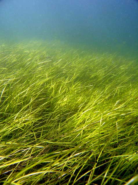
A seagrass meadow. (Christoffer Boström)
Sea grasses form the backbone of one of the most productive and biodiverse ecosystems on Earth, rivaling coral reefs and rain forests in terms of the ecosystem services they provide to humans.
Sea grass meadows are part of the soft-sediment coastal ecosystems found in all continents, with the exception of Antarctica. They not only form a nursery for young fish and other organisms, but also protect the coastline from erosion and maintain water clarity. ‘
The study, which sequenced the genome of the eel grass taken from the Archipelago Sea off Finland. published today, in the journal Nature, is the work of an international consortium of 35 labs, most of them in Europe, working with researchers from the U.S. Department of Energy Joint Genome Institute.
The study showed that eel grasses are completely submerged marine flowering plants, called by science angiosperms. It shows that eel grass is a member of the ancient monocot family.
The monocots include about 60,000 species, flowering plants that first appear above the soil as a single leaf. They include orchids, “true grasses,” as well as rice, wheat, maize and “forage grasses” such as sugar cane, and the bamboos. According to Wikipedia, other economically important monocot crops include palms bananas , gingers, onions, garlic, lilies, daffodils, irises, amaryllis, bluebells and tulips.
Zostera marina is the first marine flowering plant have its genome fully sequenced. As well as finding the eel grass’s genetic ancestors the researchers were interested in understanding how the plant–and by extension other plants in the ecosystem–adapt to climate change.
As it adapted to an underwater, coastal lifestyle, eel grass gained genes that allowed it to live in saltwater but lost genes involved in traits associated with land-based plants.
Olsen called this “arguably the most extreme adaptation a terrestrial (and even a freshwater) species can undergo.”
What she describes as the “use it, lose it, or change it” scenario, eelgrass modified its cell walls. The eel grass cell wall is very different from normal plant cell walls and more like that of sea algae, similar to the cell in seaweeds. The eel grass has lost genes associated with light-sensing, pollination and regulation of internal water balance.
Eel grass lost its stomata (which are used by land plants to ‘breathe’) but also all of the genes involved in stomatal differentiation. “The genes have just gone, so there’s no way back to land for sea grass,” Olsen says. Sex is entirely underwater involving long naked sperm filaments especially adapted for underwater fertilization of the tiny flowers.
The team compared the eel grass genome to duck weed, one of the simplest flowering plants and Zostera marina’s closest sequenced relative. They noted differences in genes related to cell wall structure due to adaptations to freshwater or terrestrial conditions. For example, plants such as duckweed have seemingly lost genes that help plants retain water in the cell wall, while eel grass has regained these genes to better deal with osmotic stress at low tide.
“They have re-engineered themselves,” said Olsen of the changes affecting the eelgrass cell walls. “Crop breeders may benefit from lessons on how salt tolerance has evolved in these plants.”
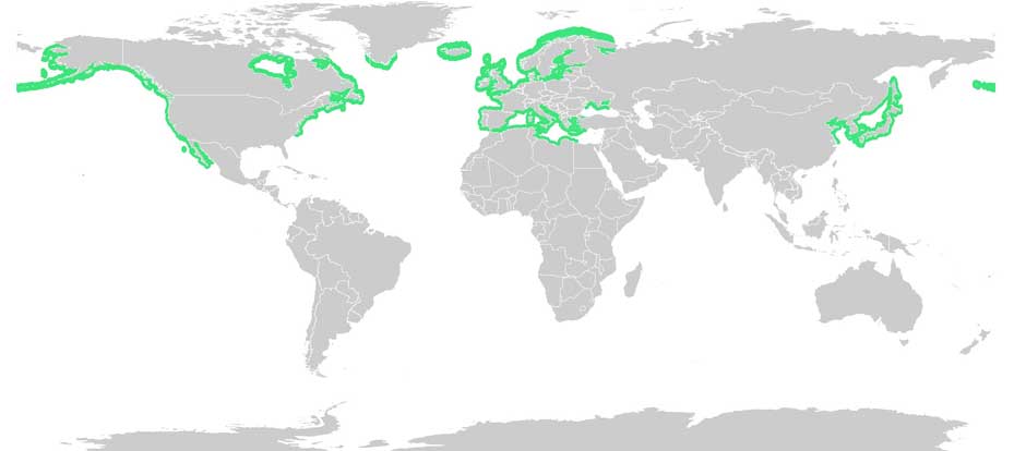
Eel grass distribution. (Wikipedia Commons(
With Zostera marina meadows stretching from Alaska to Baja California, and from the White Sea to southern Portugal, Olsen noted that these ecosystems afford researchers “a natural experiment to investigate rapid adaptation to warmer or colder waters, as well as to salinity tolerance, ocean acidification and light.”
Eel grass endangered
Jeremy Schmutz, head of the US Department of Energy’s genetic plant program, emphasized that while eel grasses are key players in coastal marine ecosystem functions and considered the “lungs of the sea,” they are also endangered. “There are estimates that nearly a third of the eel grass meadows worldwide have been destroyed by runoff into the ocean,” he said, “reducing their potential capabilities as carbon sinks. Thus, studying the adaptive capacity of eel grass is urgent to assist conservation efforts.”
An overarching question for Olsen’s team is how quickly eel grass can adapt to rapid climate change. The fact that Zostera marina grows along the coastline from Portugal to Scandinavia is being used as a natural experiment to investigate adaptation to warmer or colder water, as well as to salinity, ocean acidification and light.
There’s a dumb, dumb, really dumb idea that just won’t go away—that Enbridge could solve all its problems if only, if only, it would send the Northern Gateway Pipeline to Prince Rupert.
Enbridge long ago rejected the idea. Before Enbridge updated its website to make Gateway Facts, to make it slick and more attractive, the old website had an FAQ where Enbridge explained why it wasn’t going to Prince Rupert.
Did you consider running the pipeline to Prince Rupert where a major port already exists?
We considered Prince Rupert and Kitimat as possible locations. We carried out a feasibility study that took into account a number of considerations. The study found that the routes to Prince Rupert were too steep to safely run the pipeline, and that Kitimat was the best and safest option available.
Current proposed route for the Northern Gateway pipeline. (Enbridge)
Here in the northwest even the supporters of the Northern Gateway roll their eyes when they hear the old Prince Rupert story come up again and again – and it’s not just because these people support the Kitimat plans for Northern Gateway, it’s because those supporters (not to mention the opponents) have driven along the Skeena from Terrace to Prince Rupert.
There just isn’t any room for a pipeline. It’s a game of centimetres.
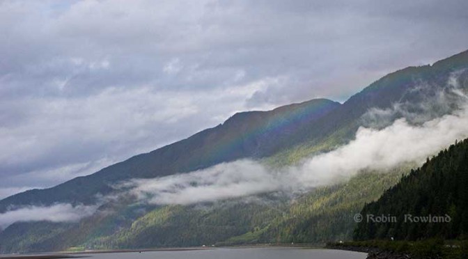
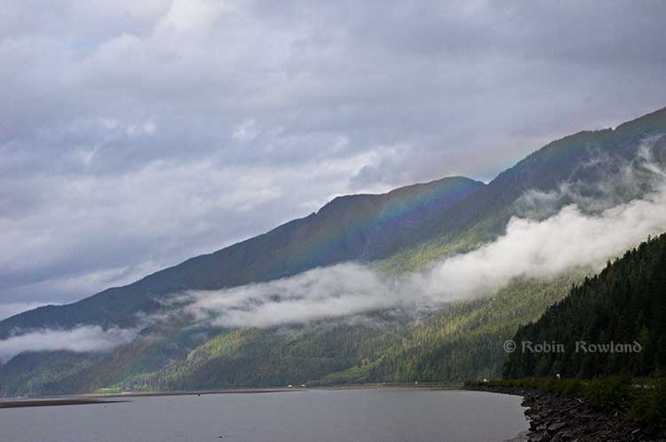
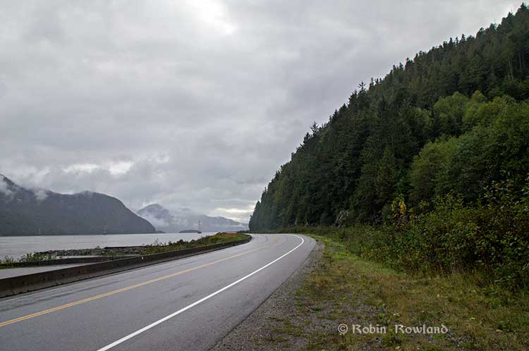
A rainbow hugs the mountains near the Telegraph Point rest area on the Skeena River between Terrace and Prince Rupert, Sept. 29, 2014. Traffic is seen on the narrow corridor between the mountains and the river (Robin Rowland/Northwest Coast Energy News)
Alternatives to Kitimat?
Now the new premier of Alberta, Jim Prentice, who should know better if he’s going to lead that province, is hinting that Kitimat isn’t the only possible solution for the Northern Gateway.
Without specifying Prince Rupert, according to Gary Mason reporting in The Globe and Mail, Prentice was speculating about an alternative to Kitimat.
Asked whether he believes the Gateway terminus should be relocated to Prince Rupert or another destination, Mr. Prentice said, “Everything I’ve heard from the Haisla who live there is they don’t agree with the terminal being in Kitimat.” Is it possible to get First Nations approval if there is no support at the planned terminus site? “It’s pretty tough,” the Premier said.
Prince Rupert has a thriving local fishing industry that employs hundreds of people and is critically important to the local First Nations. He is convinced the community would not be willing to put that at risk.
“Overwhelmingly people in my community are much more comfortable with liquefied natural gas, with wood pellets, with coal, than any oil product,” he said.
The Prince Rupert Port Authority also rejected the idea
A spokesman for the Prince Rupert Port Authority said Wednesday there is currently no room for Enbridge to build at the port even if it wanted to. “We are fully subscribed,” Michael Gurney said. There are two large vacant lots within the port authority’s jurisdiction, but both are locked by other energy companies, earmarked for LNG projects.
So not only is there no room on the road to Prince Rupert, there is no room in Prince Rupert.
Shovel-ready?
Let’s just consider for a moment that if Prince Rupert was the ideal location for the Northern Gateway terminal (which it is not), what would be needed to get the project going today.
The Northern Gateway Joint Review Panel would have be reconstituted or a new JRP created by the National Energy Board. That’s because the bitumen comes from Bruderheim, Alberta, crossing provincial boundaries and thus it’s in federal jurisdiction.
Even under the fast track rules imposed on the NEB by Stephen Harper’s Conservative government, new environmental and social impact studies would be required, starting from scratch. So add another five years of paperwork before a single shovel goes into the ground.
The pipeline would have to cross the traditional territory of First Nations that, so far, have not been part of the negotiations, mostly the Tsimshian First Nation as well as the Nisga’a First Nation which has a treaty establishing local rule over their territory.
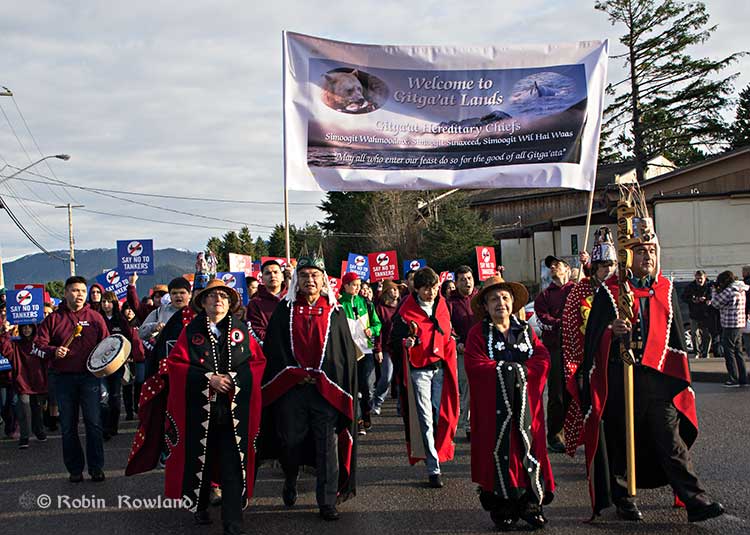
Traditional leaders of the Gitga’at First Nation lead a protest march through the streets of Prince Rupert, February 4, 2012. (Robin Rowland/Northwest Coast Energy News)
In February 2012, the largest anti-Enbridge demonstration outside of the Lower Mainland took place in Prince Rupert, with the elders of the Tsimshian First Nation welcoming the elders and members of the Gitga’at First Nation, at Hartley Bay, which had organized the protest.
When I say there isn’t room for a pipeline along the Skeena, it also means that there isn’t any room for the pipeline corridor right-of-way. Enbridge, in its submissions to the Joint Review Panel, said it requires a 25 metre wide right of way for the pipeline corridor. (For the record that’s just over 82 feet).
Along that highway, as you will see, there’s barely enough room for the CN mainline and Highway 16 (also known as the Yellowhead Highway) and on a lot of places both the highway and the railway roadbed are built on fill along the side of a cliff.
Albertans’ desperate desire to see the Northern Gateway go to anywhere to what they call “tide water” keeps coming up like the proverbial bad penny. The latest came when Jim Prentice speculated about a new route for the Northern Gateway.
I knew I had an appointment coming up in Prince Rupert on Monday, September 29. So I decided that only way to prove to people sitting in Calgary, Edmonton and Fort McMurray playing with Google Maps that the pipeline to Prince Rupert was a really dumb idea was to shoot photographs to show just why the Northern Gateway will never go to Prince Rupert—at least along the Skeena.
As you drive out of Terrace, you pass two large swing gates (also called by some “Checkpoint Charlie” gates after the Cold War era crossing in Berlin.) At the first rest stop west of Terrace, there are another set of gates at the Exstew. There’s a third set of gates just outside Prince Rupert.
A logging truck passes the avalanche gates at Exstew on Highway 16, Sept. 29, 2014. (Robin Rowland)
The swing gates are avalanche gates and, in the winter, Highway 16 can be shut down if an avalanche closes the highway or the danger from avalanche is too great to allow motorists to proceed. When you drive the highway from Terrace to Prince Rupert in the winter (the signs were covered up when I drove Monday) you are warned “Avalanche danger Next 13 kilometres. No stopping.”
The Exstew avalanche gates, (Robin Rowland/Northwest Coast Energy News)
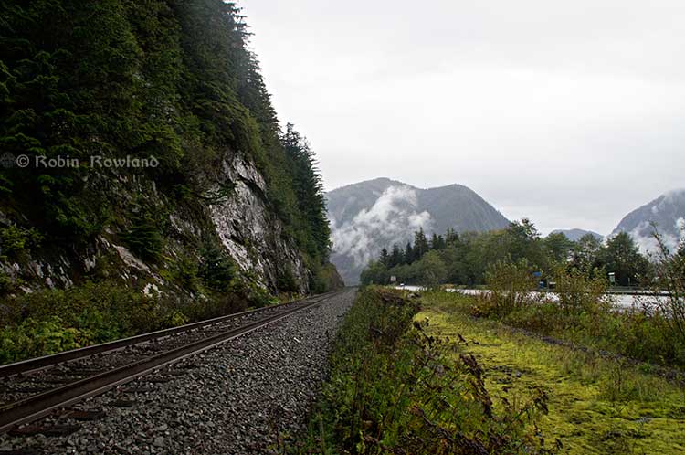
The drive along the Skeena from just west of Exchamsiks River Provincial Park all the way to Tyee where the highway turns inland to reach northwest to Prince Rupert on Kaien Island is one of the most spectacular drives on this planet. The highway snakes along a narrow strip of land with steep mountain cliffs on one side and the vast river on the other.
The problem is that apart from locals and tourists, none of the “experts” whether journalist, think tanker, bureaucrat or politician have, apparently ever driven from Prince Rupert to Terrace.
When both Opposition Leader Tom Mulcair and Liberal Leader Justin Trudeau were in the northwest earlier this summer to “engage” with the local people, apart from short boat trips down Douglas Channel, they flew everywhere. Scheduling you know. Stephen Harper has never visited northwest BC and probably never intends to. His cabinet members fly in for photo ops and then are on the next plane out of town.
Of all the visiting journalists who have come to the northwest only a couple have bothered to drive around the region. Most fly-in fly-out. These days, most often budget-strapped reporters never leave their offices, interviewing the same usual suspects by phone on every story.
On Monday, I took most of the photographs on my way back from Prince Rupert to Terrace after my appointment, so the sequence is from west to east. There are also very few places along the river where you can safely stop. There are concrete barricades on both sides of the highway to prevent vehicles either going into the river or onto the narrow CN right-of-way.
There are, however, two rest stops and a number of small turnoffs on the highway, the turnoffs mainly intended for use by BC Highways, but which are also used by tourists, fishers and photographers.
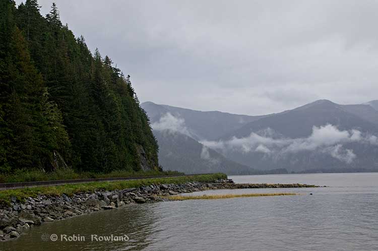
The first image was taken at one of those highway turnoffs just east of Aberdeen Creek. This is what the highway and rail corridor are like all along the Skeena, the highway, bounded by concrete barricades, the CN rail line and then the towering mountains. Note where the telegraph and telephone lines are—further up the cliffside.
A closer view of the highway and rail corridor just east of Aberdeen Creek.
Here is the view of the Skeena River from the Aberdeen Creek turnoff. You can see to the east, a mountain and the narrow strip of fill land that supports the highway and the rail line.
You see the broad width of the mighty Skeena, the Misty River, as it is called by the Tsimshian First Nation and by everyone else who lives in the northwest and on the right side of the image, the highway and rail corridor built on fill.
Any room for a pipeline?
There’s another turnoff on the other side of the headland east of Aberdeen Creek, looking back the way we came.
The final small turnoff is just by the Kylex River. Again you can see how narrow the highway and rail corridor are.
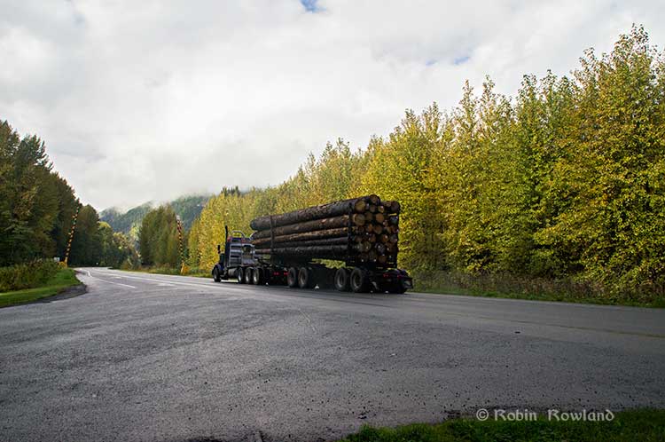
A few kilometres further along—as I said the highway snakes and curves its way along the riverbank– you come to the Basalt Creek rest area. So this telephoto image shows a logging truck heading west, taken from Basalt Creek, looking back at the highway.
Again you can see both the highway and CN line are built on fill. Is there any room for a pipeline?
Any room for a 25 metre pipeline right-of-way?
Between Basalt Creek and Telegraph Point, a few kilometres to the east, again the highway and rail line hug the narrow strip between the river and mountains.
This shot, taken from Telegraph Point, in October 2013, shows a CN intermodal container train heading to Prince Rupert. The container trains and the coal trains usually have between 150 and 180 cars. If a winter avalanche took out a train, there would be environmental damage, but that damage would be insignificant from coal or containers compared to a train of railbit tankers carrying diluted bitumen.
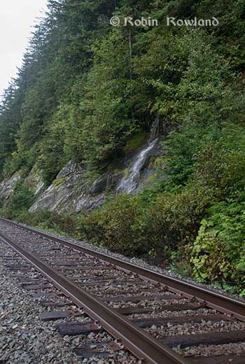
At Telegraph Point, the second of the three rest stops between Prince Rupert and Terrace, again there is just a narrow strip between the mountain, the highway and the river.
Across the highway from the rest stop, you can again see the narrow corridor, the first shot looking west the rail line close to the cliff face, the second, east, with the waterfall, which you don’t see during the rest of the year, fed by the fall monsoon.
Two shots from the same location, Telegraph Point, taken in March, 2013, of a CN locomotive hauling empty coal cars back to the fields around Tumbler Ridge. (No waterfall in March)
Alternative routes
Everyone has assumed that if Northern Gateway changed its route, the most likely choice given the configuration of the pipeline at the moment is to follow the Skeena.
There are alternatives. The Petronas LNG project and its partner TransCanada Pipelines have proposed a more northern cross-country route, which would go north from the Hazeltons, avoiding the Skeena
If Enbridge wanted to try a northern route, similar to the one TransCanada contemplates for Petronas, Northern Gateway would again run into trouble.
It would require reopening or creating a new Joint Review Panel, many more years of environmental and social impact studies of the route, even under Stephen Harper’s fast track system. The TransCanada/Petronas pipeline would also cross the traditional territory of the Gitxsan First Nation and if Enbridge tried that the company would have to deal with the fact that it signed a controversial agreement with Elmer Derrick that was immediately repudiated by most members of the Gitxsan First Nation and eventually dropped by Enbridge.
So why does this idea of a pipeline to Prince Rupert keep coming up?
In most cases, the idea of the pipeline to Prince Rupert is always proposed by Albertans, not from any credible source in British Columbia, or the suggestions come from desk bound analysts in Toronto and Ottawa both in think tanks and in the newsrooms of dying newspapers who have never seen the Skeena River apart from a tiny handful who have looked at Google Street View
(Yes you can Google Street View Highway 16 along the Skeena, I recommend it if you can’t do the drive)
Perhaps the worst example of this failure of both analysis and journalism came in the Edmonton Journal on July 7,2014, when it published a piece by Bob Russell, entitled Opinion: Make Prince Rupert the terminus, which went over the same old inaccurate arguments.
The overland route currently proposed by Enbridge is fraught with environmental issues because it goes over coastal mountains and streams before entering Kitimat’s port. This port will also be the base of perhaps as many as four liquefied natural gas terminals, which will result in the channel always busy with LNG ships outbound and returning from many Asian ports.
There are existing rights of way for the major highway, the Yellowhead, and CN Rail line from Edmonton to the Port of Prince Rupert, so this eliminates the issue of transgressing First Nations lands. The technical issues of narrow passages can be overcome with engineering. In fact, the pipeline can be buried in the roadway at some restricted locations if absolutely necessary, but two different engineers have assured me that for the most part, the right of way should be able to handle the pipeline. A vital factor, of course, is to reduce the impact by eliminating the need for two pipelines.
The clue is how the Edmonton Journal describes Russell;
Bob Russell has an extensive background in planning and was a member of the Edmonton Metro Regional Planning Commission. He has flown the Douglas Channel, visited Kitimat and toured the Port of Prince Rupert.
This is so typical of the Albertan attitude toward northwest British Columbia, people fly in for a couple of days, make a quick observation, and fly out again and present themselves as experts on the region. (Some “experts” on Kitimat, very active on Twitter have apparently never left Calgary).
It obvious that the “two engineers” who assured him “the right-of-way could handle of pipeline” have no idea what they’re talking about. As the photos show there is barely enough room for a highway and a rail line much less a 25 metre wide pipeline corridor.
If the pipeline was to be built as Russell proposed, the only highway between Prince Rupert and the rest of Canada would have to be closed for years, there are no detours. All so a pipeline can be buried under the asphalt not in solid ground, but in the fill on the side of a riverbank in an avalanche zone?
Of course, closing a highway up here won’t inconvenience anyone in Edmonton or Calgary, will it?
Would CN be happy with years of disruption of their lucrative traffic to Prince Rupert with grain and coal outbound to Asia and all those containers coming in to feed Chinese products to the North American market? (you can be sure Walmart wouldn’t be happy about that, not to mention prairie farmers including those from Alberta)
Russell’s statement
There are existing rights of way for the major highway, the Yellowhead, and CN Rail line from Edmonton to the Port of Prince Rupert, so this eliminates the issue of transgressing First Nations lands.
Is also inaccurate.
I was told by First Nations leaders during the Idle No More demonstrations in the winter of 2013, that, a century ago, when the Grand Trunk built the railway along the Skeena , they did just that, built it without consulting the First Nations along the route, sometime digging up native cemeteries and sacred spots.
While apparently CN has worked in recent years to improve relations with the First Nations along the rail line, according to those leaders some issues of right-of-way remain to be resolved.
If there were any plans to build a diluted bitumen pipeline along that route, that would likely mean another court battle adding to those already before the Federal Court, a court battle that would cost Enbridge, CN, the federal government, environmental NGOs and the First Nations more millions in lawyers’ fees.
It’s doubtful if in the long gone (and perhaps mythical) days of “get it right” journalism that the Russell opinion piece would have passed the scrutiny of an old fashioned copy editor and fact checker.
In 2012, the Edmonton Journal (in a story no longer available on their website) also cited former Alberta Premier Peter Lougheed and former Bank of Canada governor David Dodge, as also favouring Prince Rupert.
Dodge, who was in Edmonton Tuesday to deliver a speech on the global economic outlook at MacEwan University, said Enbridge’s proposed Northern Gateway pipeline to Kitimat looks like even more of a long shot.
“I think the project to Kitimat looks, objectively, more risky. So why hasn’t much greater effort gone into looking at Prince Rupert and taking (bitumen) out that way? My guess is, the easiest place to get B.C. to buy into the project would be to go to Rupert.”
Dodge’s views echo those of former Alberta Premier Peter Lougheed, who also favours looking at an alternate pipeline route to Prince Rupert, where ocean-going supertankers can navigate more easily.
Back in 2012, I finished my piece for the Huffington Post by saying:
So why do people insist, despite the evidence, that the Northern Gateway go to Prince Rupert? It’s no longer an pipeline; it’s emotion and ideology. Ideology in that opposition to the Northern Gateway is seen by conservatives as heretical opposition to free enterprise itself. Emotion among those who see promoting the oil patch as an issue of “Alberta pride” and even Canadian patriotism.
For the promoters of the pipeline to Prince Rupert, ignoring the science of geology and the study of geography across all of northwestern B.C. is no different than repeatedly knocking your head against the Paleozoic metamorphic greenstone of the mountain cliffs along the Skeena. It only gives you a headache.
Things haven’t gotten much better in the past two years. In fact they’re getting worse as opposition to pipelines mounts.
It seems that in 2014 the Alberta and the federal government policy in promoting pipelines Northern Gateway, KinderMorgan’s TransMountain, Keystone XL, Line 9 Reversal and Energy East (slick PR and smiling representatives at open houses, politicians at strictly controlled photo ops) is to ignore facts on the ground and to refuse to deal with the concerns of local people from coast to coast.
There could, perhaps, be a more inclusive and truly science-based pipeline planning process that could see pipelines go on optimum routes but that isn’t happening.
The policy for the oil patch and its politician supporters when it comes to pipelines is facts and geology don’t really matter. So they put on ruby slippers, knock their heels together three times and send pipelines down a yellow brick road to an Emerald City (while telling the locals to ignore the man behind the curtain)
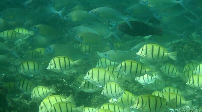
Tropical fish are migrating into what were once temperate water as a result of ocean warming and that poses a serious threat to the areas they invade, because they overgraze on kelp forests and seagrass meadows, according to a new study from the University of New South Wales in Australia
The study says the harmful impact of tropical fish is most evident in southern Japanese waters and the eastern Mediterranean, where there have been dramatic declines in kelps.
A school of tropical plant-eating fish including various species that are shifting their distribution towards temperate waters. (Adriana Verges/UNSW)
There is also emerging evidence in Australia and the US that the spread of tropical fish towards the poles is causing damage in the areas they enter.
“The tropicalisation of temperate marine areas is a new phenomenon of global significance that has arisen because of climate change,” according to the study lead author, Dr. Adriana Verges, of the University of New South Wales.
“Increases in the number of plant-eating tropical fish can profoundly alter ecosystems and lead to barren reefs, affecting the biodiversity of these regions, with significant economic and management impacts.”
The study is published in the journal Proceedings of the Royal Society B.
As the oceans have warmed and the climate has changed, hotspots are developing in regions where the currents that transport warm tropical waters towards the poles are strengthening.
Increased flow of the East Australian Current, for example, has meant waters south-east of the continent are warming at two to three times the global average.
Tropical fish are now common in Sydney Harbour during the summer months.
Japan, the east coast of the US, northern Brazil and south eastern Africa are also strongly influenced by coastal currents that transport warm tropical waters.
“In tropical regions, a wide diversity of plant-eating fish perform the vital role of keeping reefs free of large seaweeds, allowing corals to flourish. But when they intrude into temperate waters they pose a significant threat to these habitats. They can directly overgraze algal forests as well as prevent the recovery of algae that have been damaged for other reasons,” Dr Verges said.
Tropical fish expanding their ranges into temperate areas include unicornfish, parrotfish, and rabbitfish.
The study authors include researchers from Australia, the US, Spain, Singapore, the UK and Japan.
Kelp disappears in southern Japan
The study reports that more than 40 per cent of the kelp and algal beds have disappeared since the 1990s, a phenomenon known in Japan as isoyake.
Tropical species including rabbitfish and parrotfish appear to be mainly responsible.
Although these fish have been present for a long time, their annual grazing rates have increased dramatically as ocean temperatures in winter have risen. Corals now dominate the ecosystem in many locations. The changes have led to the collapse of the abalone fishery.
Rabbit fish expand in eastern Mediterranean
Tropical fish moved into the eastern Mediterranean from the Red Sea after the opening of the Suez Canal. In recent decades, rabbitfish numbers have increased, resulting in hundreds of kilometres of deforested areas and a 40 per cent decrease in the variety of marine species.
As the Mediterranean warms the rabbitfish are expanding their range westward, putting other shallow ecosystems at risk.
Gulf of Mexico
There has been a more than 20-fold increase in the number of parrotfish in the Gulf of Mexico – a species which consumes seagrass at five times the rate of native grazers. The number of plant-eating green turtles and manatees has also increased.
Australia
In Western Australia, emerging evidence suggests that increases in the number of tropical fish are preventing the recovery of kelp forest damaged by a heat wave in 2011.
In eastern Australia, kelp has disappeared from numerous reefs in the past five years and Dr Verges’ research suggests intense grazing by tropical fish on the kelp preceded this.