There’s a dumb, dumb, really dumb idea that just won’t go away—that Enbridge could solve all its problems if only, if only, it would send the Northern Gateway Pipeline to Prince Rupert.
Enbridge long ago rejected the idea. Before Enbridge updated its website to make Gateway Facts, to make it slick and more attractive, the old website had an FAQ where Enbridge explained why it wasn’t going to Prince Rupert.
Did you consider running the pipeline to Prince Rupert where a major port already exists?
We considered Prince Rupert and Kitimat as possible locations. We carried out a feasibility study that took into account a number of considerations. The study found that the routes to Prince Rupert were too steep to safely run the pipeline, and that Kitimat was the best and safest option available.
Current proposed route for the Northern Gateway pipeline. (Enbridge)
Here in the northwest even the supporters of the Northern Gateway roll their eyes when they hear the old Prince Rupert story come up again and again – and it’s not just because these people support the Kitimat plans for Northern Gateway, it’s because those supporters (not to mention the opponents) have driven along the Skeena from Terrace to Prince Rupert.
There just isn’t any room for a pipeline. It’s a game of centimetres.
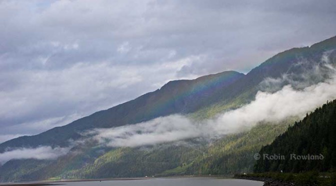
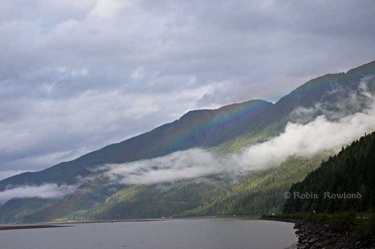
A rainbow hugs the mountains near the Telegraph Point rest area on the Skeena River between Terrace and Prince Rupert, Sept. 29, 2014. Traffic is seen on the narrow corridor between the mountains and the river (Robin Rowland/Northwest Coast Energy News)
Alternatives to Kitimat?
Now the new premier of Alberta, Jim Prentice, who should know better if he’s going to lead that province, is hinting that Kitimat isn’t the only possible solution for the Northern Gateway.
Without specifying Prince Rupert, according to Gary Mason reporting in The Globe and Mail, Prentice was speculating about an alternative to Kitimat.
Asked whether he believes the Gateway terminus should be relocated to Prince Rupert or another destination, Mr. Prentice said, “Everything I’ve heard from the Haisla who live there is they don’t agree with the terminal being in Kitimat.” Is it possible to get First Nations approval if there is no support at the planned terminus site? “It’s pretty tough,” the Premier said.
Prince Rupert has a thriving local fishing industry that employs hundreds of people and is critically important to the local First Nations. He is convinced the community would not be willing to put that at risk.
“Overwhelmingly people in my community are much more comfortable with liquefied natural gas, with wood pellets, with coal, than any oil product,” he said.
The Prince Rupert Port Authority also rejected the idea
A spokesman for the Prince Rupert Port Authority said Wednesday there is currently no room for Enbridge to build at the port even if it wanted to. “We are fully subscribed,” Michael Gurney said. There are two large vacant lots within the port authority’s jurisdiction, but both are locked by other energy companies, earmarked for LNG projects.
So not only is there no room on the road to Prince Rupert, there is no room in Prince Rupert.
Shovel-ready?
Let’s just consider for a moment that if Prince Rupert was the ideal location for the Northern Gateway terminal (which it is not), what would be needed to get the project going today.
The Northern Gateway Joint Review Panel would have be reconstituted or a new JRP created by the National Energy Board. That’s because the bitumen comes from Bruderheim, Alberta, crossing provincial boundaries and thus it’s in federal jurisdiction.
Even under the fast track rules imposed on the NEB by Stephen Harper’s Conservative government, new environmental and social impact studies would be required, starting from scratch. So add another five years of paperwork before a single shovel goes into the ground.
The pipeline would have to cross the traditional territory of First Nations that, so far, have not been part of the negotiations, mostly the Tsimshian First Nation as well as the Nisga’a First Nation which has a treaty establishing local rule over their territory.
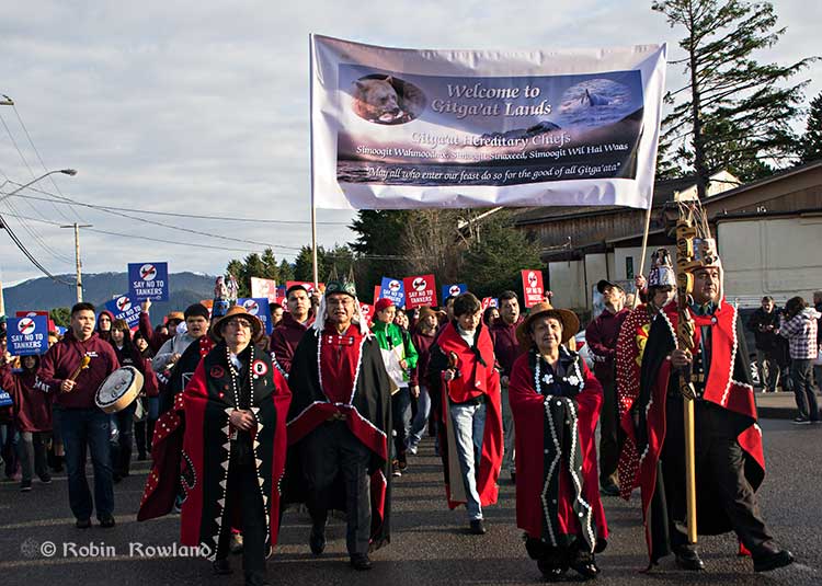
Traditional leaders of the Gitga’at First Nation lead a protest march through the streets of Prince Rupert, February 4, 2012. (Robin Rowland/Northwest Coast Energy News)
In February 2012, the largest anti-Enbridge demonstration outside of the Lower Mainland took place in Prince Rupert, with the elders of the Tsimshian First Nation welcoming the elders and members of the Gitga’at First Nation, at Hartley Bay, which had organized the protest.
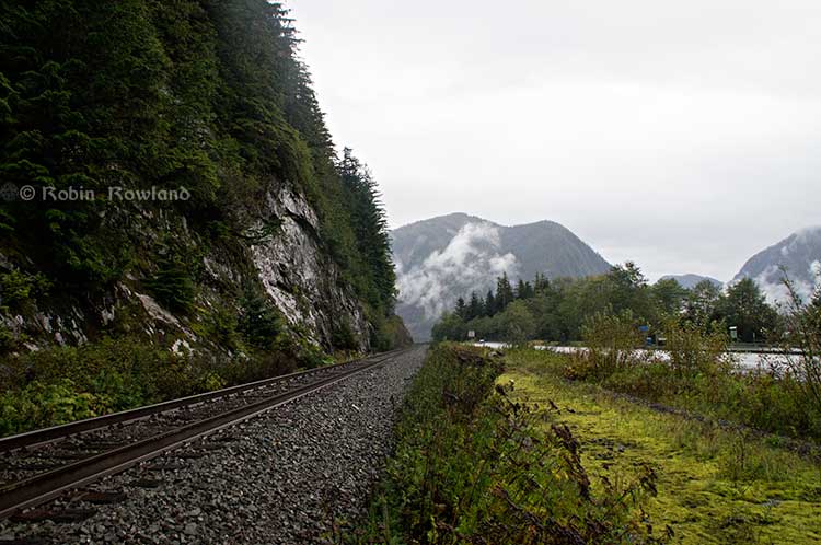
When I say there isn’t room for a pipeline along the Skeena, it also means that there isn’t any room for the pipeline corridor right-of-way. Enbridge, in its submissions to the Joint Review Panel, said it requires a 25 metre wide right of way for the pipeline corridor. (For the record that’s just over 82 feet).
Along that highway, as you will see, there’s barely enough room for the CN mainline and Highway 16 (also known as the Yellowhead Highway) and on a lot of places both the highway and the railway roadbed are built on fill along the side of a cliff.
Albertans’ desperate desire to see the Northern Gateway go to anywhere to what they call “tide water” keeps coming up like the proverbial bad penny. The latest came when Jim Prentice speculated about a new route for the Northern Gateway.
I knew I had an appointment coming up in Prince Rupert on Monday, September 29. So I decided that only way to prove to people sitting in Calgary, Edmonton and Fort McMurray playing with Google Maps that the pipeline to Prince Rupert was a really dumb idea was to shoot photographs to show just why the Northern Gateway will never go to Prince Rupert—at least along the Skeena.
As you drive out of Terrace, you pass two large swing gates (also called by some “Checkpoint Charlie” gates after the Cold War era crossing in Berlin.) At the first rest stop west of Terrace, there are another set of gates at the Exstew. There’s a third set of gates just outside Prince Rupert.
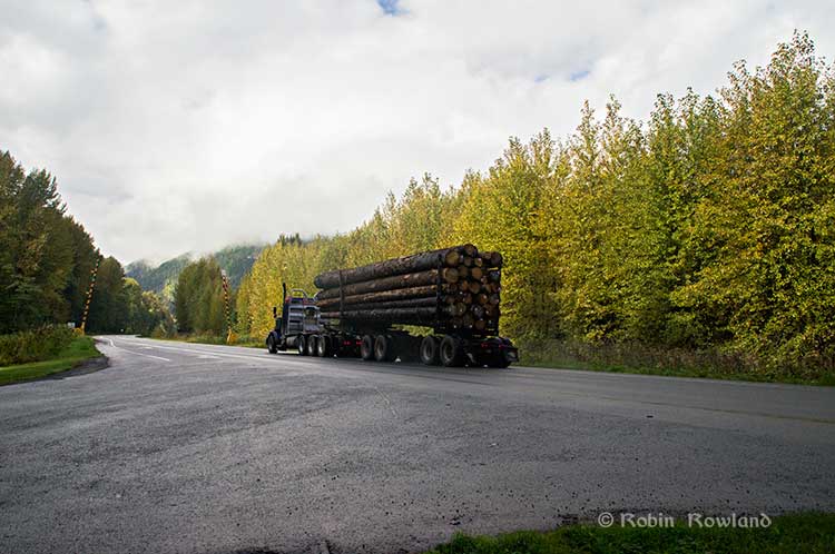
A logging truck passes the avalanche gates at Exstew on Highway 16, Sept. 29, 2014. (Robin Rowland)
The swing gates are avalanche gates and, in the winter, Highway 16 can be shut down if an avalanche closes the highway or the danger from avalanche is too great to allow motorists to proceed. When you drive the highway from Terrace to Prince Rupert in the winter (the signs were covered up when I drove Monday) you are warned “Avalanche danger Next 13 kilometres. No stopping.”
The Exstew avalanche gates, (Robin Rowland/Northwest Coast Energy News)
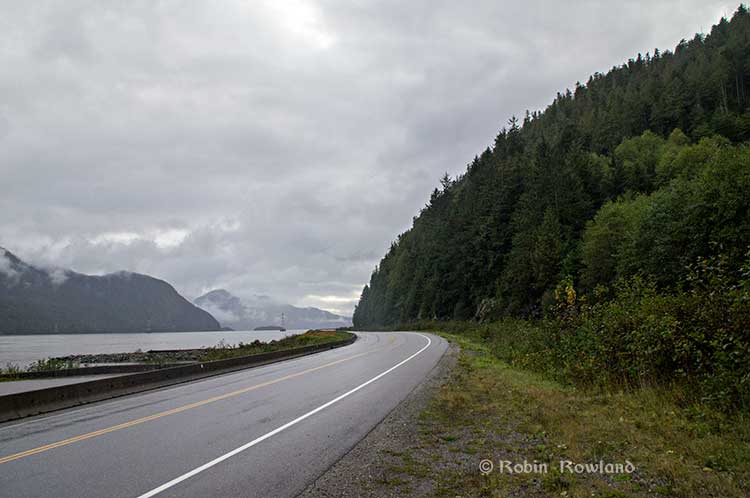
The drive along the Skeena from just west of Exchamsiks River Provincial Park all the way to Tyee where the highway turns inland to reach northwest to Prince Rupert on Kaien Island is one of the most spectacular drives on this planet. The highway snakes along a narrow strip of land with steep mountain cliffs on one side and the vast river on the other.
The problem is that apart from locals and tourists, none of the “experts” whether journalist, think tanker, bureaucrat or politician have, apparently ever driven from Prince Rupert to Terrace.
When both Opposition Leader Tom Mulcair and Liberal Leader Justin Trudeau were in the northwest earlier this summer to “engage” with the local people, apart from short boat trips down Douglas Channel, they flew everywhere. Scheduling you know. Stephen Harper has never visited northwest BC and probably never intends to. His cabinet members fly in for photo ops and then are on the next plane out of town.
Of all the visiting journalists who have come to the northwest only a couple have bothered to drive around the region. Most fly-in fly-out. These days, most often budget-strapped reporters never leave their offices, interviewing the same usual suspects by phone on every story.
On Monday, I took most of the photographs on my way back from Prince Rupert to Terrace after my appointment, so the sequence is from west to east. There are also very few places along the river where you can safely stop. There are concrete barricades on both sides of the highway to prevent vehicles either going into the river or onto the narrow CN right-of-way.
There are, however, two rest stops and a number of small turnoffs on the highway, the turnoffs mainly intended for use by BC Highways, but which are also used by tourists, fishers and photographers.
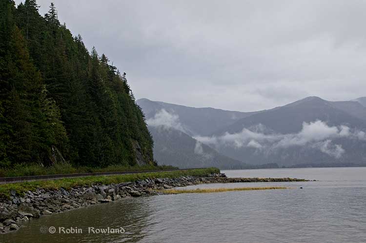
The first image was taken at one of those highway turnoffs just east of Aberdeen Creek. This is what the highway and rail corridor are like all along the Skeena, the highway, bounded by concrete barricades, the CN rail line and then the towering mountains. Note where the telegraph and telephone lines are—further up the cliffside.
A closer view of the highway and rail corridor just east of Aberdeen Creek.
Here is the view of the Skeena River from the Aberdeen Creek turnoff. You can see to the east, a mountain and the narrow strip of fill land that supports the highway and the rail line.
You see the broad width of the mighty Skeena, the Misty River, as it is called by the Tsimshian First Nation and by everyone else who lives in the northwest and on the right side of the image, the highway and rail corridor built on fill.
Any room for a pipeline?
There’s another turnoff on the other side of the headland east of Aberdeen Creek, looking back the way we came.
The final small turnoff is just by the Kylex River. Again you can see how narrow the highway and rail corridor are.
A few kilometres further along—as I said the highway snakes and curves its way along the riverbank– you come to the Basalt Creek rest area. So this telephoto image shows a logging truck heading west, taken from Basalt Creek, looking back at the highway.
Again you can see both the highway and CN line are built on fill. Is there any room for a pipeline?
Any room for a 25 metre pipeline right-of-way?
Between Basalt Creek and Telegraph Point, a few kilometres to the east, again the highway and rail line hug the narrow strip between the river and mountains.
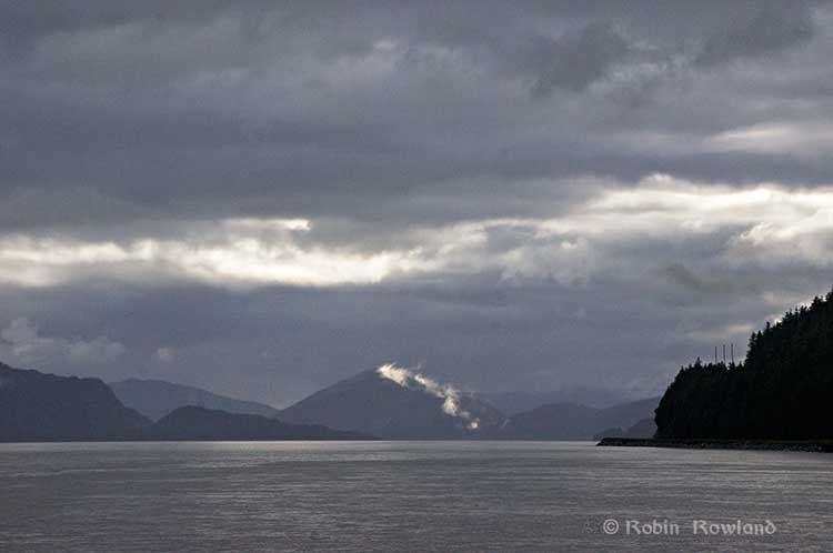
This shot, taken from Telegraph Point, in October 2013, shows a CN intermodal container train heading to Prince Rupert. The container trains and the coal trains usually have between 150 and 180 cars. If a winter avalanche took out a train, there would be environmental damage, but that damage would be insignificant from coal or containers compared to a train of railbit tankers carrying diluted bitumen.
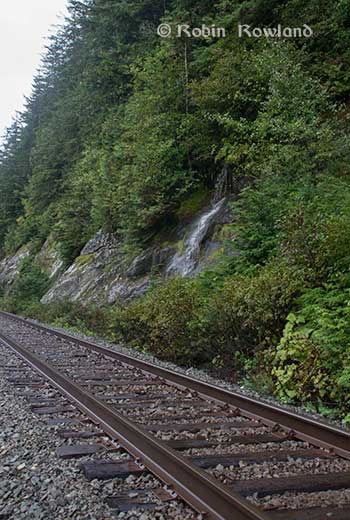
At Telegraph Point, the second of the three rest stops between Prince Rupert and Terrace, again there is just a narrow strip between the mountain, the highway and the river.
Across the highway from the rest stop, you can again see the narrow corridor, the first shot looking west the rail line close to the cliff face, the second, east, with the waterfall, which you don’t see during the rest of the year, fed by the fall monsoon.
Two shots from the same location, Telegraph Point, taken in March, 2013, of a CN locomotive hauling empty coal cars back to the fields around Tumbler Ridge. (No waterfall in March)
Alternative routes
Everyone has assumed that if Northern Gateway changed its route, the most likely choice given the configuration of the pipeline at the moment is to follow the Skeena.
There are alternatives. The Petronas LNG project and its partner TransCanada Pipelines have proposed a more northern cross-country route, which would go north from the Hazeltons, avoiding the Skeena
If Enbridge wanted to try a northern route, similar to the one TransCanada contemplates for Petronas, Northern Gateway would again run into trouble.
It would require reopening or creating a new Joint Review Panel, many more years of environmental and social impact studies of the route, even under Stephen Harper’s fast track system. The TransCanada/Petronas pipeline would also cross the traditional territory of the Gitxsan First Nation and if Enbridge tried that the company would have to deal with the fact that it signed a controversial agreement with Elmer Derrick that was immediately repudiated by most members of the Gitxsan First Nation and eventually dropped by Enbridge.
So why does this idea of a pipeline to Prince Rupert keep coming up?
In most cases, the idea of the pipeline to Prince Rupert is always proposed by Albertans, not from any credible source in British Columbia, or the suggestions come from desk bound analysts in Toronto and Ottawa both in think tanks and in the newsrooms of dying newspapers who have never seen the Skeena River apart from a tiny handful who have looked at Google Street View
(Yes you can Google Street View Highway 16 along the Skeena, I recommend it if you can’t do the drive)
Perhaps the worst example of this failure of both analysis and journalism came in the Edmonton Journal on July 7,2014, when it published a piece by Bob Russell, entitled Opinion: Make Prince Rupert the terminus, which went over the same old inaccurate arguments.
The overland route currently proposed by Enbridge is fraught with environmental issues because it goes over coastal mountains and streams before entering Kitimat’s port. This port will also be the base of perhaps as many as four liquefied natural gas terminals, which will result in the channel always busy with LNG ships outbound and returning from many Asian ports.
There are existing rights of way for the major highway, the Yellowhead, and CN Rail line from Edmonton to the Port of Prince Rupert, so this eliminates the issue of transgressing First Nations lands. The technical issues of narrow passages can be overcome with engineering. In fact, the pipeline can be buried in the roadway at some restricted locations if absolutely necessary, but two different engineers have assured me that for the most part, the right of way should be able to handle the pipeline. A vital factor, of course, is to reduce the impact by eliminating the need for two pipelines.
The clue is how the Edmonton Journal describes Russell;
Bob Russell has an extensive background in planning and was a member of the Edmonton Metro Regional Planning Commission. He has flown the Douglas Channel, visited Kitimat and toured the Port of Prince Rupert.
This is so typical of the Albertan attitude toward northwest British Columbia, people fly in for a couple of days, make a quick observation, and fly out again and present themselves as experts on the region. (Some “experts” on Kitimat, very active on Twitter have apparently never left Calgary).
It obvious that the “two engineers” who assured him “the right-of-way could handle of pipeline” have no idea what they’re talking about. As the photos show there is barely enough room for a highway and a rail line much less a 25 metre wide pipeline corridor.
If the pipeline was to be built as Russell proposed, the only highway between Prince Rupert and the rest of Canada would have to be closed for years, there are no detours. All so a pipeline can be buried under the asphalt not in solid ground, but in the fill on the side of a riverbank in an avalanche zone?
Of course, closing a highway up here won’t inconvenience anyone in Edmonton or Calgary, will it?
Would CN be happy with years of disruption of their lucrative traffic to Prince Rupert with grain and coal outbound to Asia and all those containers coming in to feed Chinese products to the North American market? (you can be sure Walmart wouldn’t be happy about that, not to mention prairie farmers including those from Alberta)
Russell’s statement
There are existing rights of way for the major highway, the Yellowhead, and CN Rail line from Edmonton to the Port of Prince Rupert, so this eliminates the issue of transgressing First Nations lands.
Is also inaccurate.
I was told by First Nations leaders during the Idle No More demonstrations in the winter of 2013, that, a century ago, when the Grand Trunk built the railway along the Skeena , they did just that, built it without consulting the First Nations along the route, sometime digging up native cemeteries and sacred spots.
While apparently CN has worked in recent years to improve relations with the First Nations along the rail line, according to those leaders some issues of right-of-way remain to be resolved.
If there were any plans to build a diluted bitumen pipeline along that route, that would likely mean another court battle adding to those already before the Federal Court, a court battle that would cost Enbridge, CN, the federal government, environmental NGOs and the First Nations more millions in lawyers’ fees.
It’s doubtful if in the long gone (and perhaps mythical) days of “get it right” journalism that the Russell opinion piece would have passed the scrutiny of an old fashioned copy editor and fact checker.
In 2012, the Edmonton Journal (in a story no longer available on their website) also cited former Alberta Premier Peter Lougheed and former Bank of Canada governor David Dodge, as also favouring Prince Rupert.
Dodge, who was in Edmonton Tuesday to deliver a speech on the global economic outlook at MacEwan University, said Enbridge’s proposed Northern Gateway pipeline to Kitimat looks like even more of a long shot.
“I think the project to Kitimat looks, objectively, more risky. So why hasn’t much greater effort gone into looking at Prince Rupert and taking (bitumen) out that way? My guess is, the easiest place to get B.C. to buy into the project would be to go to Rupert.”
Dodge’s views echo those of former Alberta Premier Peter Lougheed, who also favours looking at an alternate pipeline route to Prince Rupert, where ocean-going supertankers can navigate more easily.
Back in 2012, I finished my piece for the Huffington Post by saying:
So why do people insist, despite the evidence, that the Northern Gateway go to Prince Rupert? It’s no longer an pipeline; it’s emotion and ideology. Ideology in that opposition to the Northern Gateway is seen by conservatives as heretical opposition to free enterprise itself. Emotion among those who see promoting the oil patch as an issue of “Alberta pride” and even Canadian patriotism.
For the promoters of the pipeline to Prince Rupert, ignoring the science of geology and the study of geography across all of northwestern B.C. is no different than repeatedly knocking your head against the Paleozoic metamorphic greenstone of the mountain cliffs along the Skeena. It only gives you a headache.
Things haven’t gotten much better in the past two years. In fact they’re getting worse as opposition to pipelines mounts.
It seems that in 2014 the Alberta and the federal government policy in promoting pipelines Northern Gateway, KinderMorgan’s TransMountain, Keystone XL, Line 9 Reversal and Energy East (slick PR and smiling representatives at open houses, politicians at strictly controlled photo ops) is to ignore facts on the ground and to refuse to deal with the concerns of local people from coast to coast.
There could, perhaps, be a more inclusive and truly science-based pipeline planning process that could see pipelines go on optimum routes but that isn’t happening.
The policy for the oil patch and its politician supporters when it comes to pipelines is facts and geology don’t really matter. So they put on ruby slippers, knock their heels together three times and send pipelines down a yellow brick road to an Emerald City (while telling the locals to ignore the man behind the curtain)
Supporters of David Black’s Kitimat Clean project to build a refinery about 25 kilometres north of Kitimat have been met by skepticism by experts and economists from the Canadian oil patch who keep telling the people of northwestern British Columbia that to create jobs by adding value to Alberta crude is uneconomic.
The Americans, apparently, have a different view, with plans announced for shipping projects in Washington State that could handle not only oil shale crude from the Bakken Formation in the Dakotas but also Canadian “heavy crude” aimed at refineries in Californa, refineries that would require new or renovated facilities.
So let’s add another question to northwest BC’s skepticism about the Alberta oil patch. Why is uneconomic to refine in Alberta or BC, but apparently increasingly economic to refine in California given the cost of building or rebuilding facilites?
Opponents of the Northern Gateway pipeline have always speculated that any bitumen exported from Kitimat could end up in California rather than markets in Asia.
According to reports, the Vancouver, Washington, project plans to load the bitumen on barges for shipment to California, which is likely to cause a storm of controversy with environmental groups in both states, especially if a barge, which has almost no controls compared to a tanker, foundered and ended up on the coast. [adsanity id=5199 align=alignright /]
The New York Times, on Oct. 31, looked at the issue in a report Looking for a Way Around Keystone XL, Canadian Oil Hits the Rails. The issue of moving crude by rail has been gaining traction in recent months, with growing opposition to pipeline projects. But where do those long trains of tank cars full of crude go?
Times reporter Clifford Kraus says:
The developing rail links for oil sands range across Canada and over the border from the Gulf Coast to Washington and California. Railways can potentially give Canadian producers a major outlet to oil-hungry China, including from refineries in Washington and California.
According to the Times, the plans call for two Canadian export terminals.
“We want to diversify our markets beyond just moving our product south,” said Peter Symons, a spokesman for Statoil, a Norwegian oil giant that has signed contracts to lease two Canadian oil loading terminals. “We can get that product on a ship and get it to premium markets in Asia.”
The Americans, on the other hand, are looking toward refineries.
Again the Times report says:
Several Washington and Oregon refiners and ports are planning or building rail projects for Canadian heavy crude as well as light oil from North Dakota. The Texas refinery giant Tesoro and the oil services company Savage have announced a joint venture to build a $100 million, 42-acre oil-handling plant in the Port of Vancouver on the Columbia River that could handle 380,000 barrels of oil each day if permits are granted.
Not that everything is clear sailing. The Times says there is resistance to a plan to refine heavy crude in California.
The city of Benicia, Calif., last month delayed the granting of a permit for Valero Energy’s planned rail terminal at its refinery by deciding to require an environmental impact report after residents expressed concerns that Valero would use the terminal to import Canadian oil sands crude.
With access to rail and existing marine infrastructure, the Port of Vancouver is uniquely positioned to serve as a hub for the distribution of North American crude oil to West Coast refining centers. Tesoro and Savage are ideal partners for this project, having already operated in close partnership for almost ten years on the West Coast. The Tesoro-Savage Joint Venture’s combined capabilities, experience and resources are expected to create substantial benefits for the Port and the Vancouver community in the form of sustainable revenue to the Port and local jobs associated with the facility’s construction and operation.
The Tesoro news release quotes Greg Goff, President and CEO of Tesoro.
Building upon the recent success of the rail unloading facility at our Anacortes, Wash., refinery, where we have been delivering Mid-Continent crude oil via unit train in an environmentally sound and cost-effective manner, this project is the ideal next step for Tesoro as we drive additional feedstock cost advantage to the remaining refineries in our West Coast system.
While the Tesoro April release doesn’t specifically mention heavy crude or bitumen from Alberta, in August, Reuters reporting on a Tesoro results conference call said, the project would “supply cheaper U.S. and Canadian crude to refineries all along the West Coast – both its own and those run by competitors.”
The project, which would initially have capacity of 120,000 barrels a day and could be expanded to 280,000 BPD, is the biggest so far proposed to help Pacific Coast refineries tap growing output of inland U.S. and Canadian heavy crudes.
The project, where North Dakota Bakken and Canadian crude would travel by rail to the marine facility in Vancouver, Washington and then barged to refining centers, is being planned with joint venture partner Savage Companies.
The Port of Vancouver facility will have “a lot of flexibility and capability to take different types of crudes, from heavy Canadian crudes to crudes from the Mid-Continent… So we will source crude from where the best place is,” Goff said on Aug. 2. “The facility also was designed to supply the entire West Coast… We can go from as far away as Alaska to Southern California, in those refineries, which we intend to do.”
Reuters also reported
Regulators also are considering Valero’s permit request for a 60,000 bpd rail facility at its 78,000 bpd Wilmington refinery near Los Angeles, but in June the area pollution regulator said it would take 18 months to finish an environmental review, permitting and construction.
Alon Energy USA also is seeking permits for a rail facility at its Southern California refining system, which shut down late last year as losses mounted on high imported crude costs and low asphalt demand. The company hopes to get those permits by year-end.
Valero spokesman Bill Day on Friday declined to say whether Valero would be interested in tapping inland and Canadian crude through the Tesoro project, but noted that the company values flexibility in getting cheaper crudes to its refineries.
Asked today about the New York Times report, (at the time of his regular news conference, he hadn’t read the story) Skeena Bulkley Valley MP Nathan Cullen said, “I mean there’s been so much uncertainty, in large part created by this government with respect to moving oil anywhere. This is another proposal, it seems every week you wake up, open the papers and there’s another proposal. Some of them are legitimate, some of them are snake oil.
“This one I’m not familiar with, so I can’t make specific comments on it, I will certainly look at it because I’m very interested in energy on the west coast. I’d have to see, given the government we have in Ottawa right now, they’re not friends to communities and First Nations and certainly not friends to the oil sector because they keep causing so much concern within the broader public and hurt the companies’ ability to gain social licence to get a project going.”
The future of tankers sailing along the British Columbia coast, and the export of crude through BC could change drastically by the end of 2014.
By some time in 2014, the planned expansion of the Panama Canal will be complete, allowing more large ships, including tankers, to pass through the Canal and ply up and down the west coast.
It is also possible that British Columbia coastal ports could not only be used for export of bitumen from the Alberta oil sands and liquified natural gas from northeast BC, but also for oil shale crude found in the Bakken Shale formation in North Dakota and Montana, possibly later shale oil from Saskatchewan and Manitoba.
The Keystone EIS surprisingly contains a number of scenarios in British Columbia, even though BC is thousands of kilometres from the proposed TransCanada pipeline from the bitumen sands to the refineries on the US Gulf Coast.
The State Department report had to give President Barack Obama all possible options and that it why the EIS report included what it calls “no action alternatives” –what would happen to the bitumen and oil if Obama rejects the Keystone pipeline. Assuming that the oil, whether bitumen or Bakken oil shale has to get to the Gulf refineries by other means, the EIS takes a close look at one case, via CN rail to Prince Rupert, from Prince Rupert by tanker down to the expanded Panama Canal, then through the Panama Canal to the oil ports of Texas and Louisiana.
Another possibility, although less detailed in the EIS, also considers scenarios where bitumen from the Alberta oilsands or shale crude from the Bakken formation was shipped to Vancouver via the Kinder Morgan pipeline system, to Kitimat via the proposed Northern Gateway pipeline.
The State Department rejected the Kinder Morgan and Northern Gateway options for detailed analysis because of the controversy over both projects.
The Keystone EIS was released by the State Department on Friday, March 1, 2013, and is seen as generally favouring TransCanada’s Keystone XL pipeline project. Despite the EIS report conclusions that the Keystone project would have little adverse impact, the final decision by President Obama will be largely political.
The Prince Rupert scenario
The State Department “Supplementary Enviromental Impact Statement” on the Prince Rupert and several other scenarios were undertaken
In developing alternative transport scenarios, efforts were made to focus on scenarios that would be practical (e.g., economically competitive), take advantage of existing infrastructure to the extent possible, used proven technologies, and are similar to transport options currently being utilized.
The State Department studied a scenario that would
Use of approximately 1,100 miles (1,770 kilometres) of existing rail lines from the proposed Lloydminster rail terminal complex to a new approximately 3,500-acre (1,400 hectare) rail terminal complex where the oil would be offloaded from the rail cars, with a short pipeline connection to the port at Prince Rupert.
That possible replacement for Keystone scenario calls for adding approximately 13 trains with 100 tanker car per day on the CN and Canadian Pacific rail lines between Lloydminster and Prince Rupert. (There is also a separate scenario for a rail route from Alberta to the US Gulf Coast. That scenario is not examined in this report)
That, of course, would be in addition to the already heavy rail traffic to Prince Rupert with grain and coal trains outbound and container trains inbound, as well as the VIA Skeena passenger train.
(David Black who is planning a possible refinery at Onion Flats, north of Kitimat, has said that if the Northern Gateway pipeline is stopped, the Kitimat refinery could be serviced by six trains per day, 120 cars in each direction.)
The railway to Prince Rupert is evaluated using the same criterion under US law that was used to evaluate the Keystone project, including affects on surface water, wetlands, the coast, wildlife, threatened and endangered species, fisheries, landuse, construction, green house gases and even sea level rise.
The EIS for Prince Rupert, however, dodges one of the key questions that is plaguing the Northern Gateway Joint Review panel. While it points out the possible dangers of an oil spill, the report does not go into any great detail,
The overall EIS view of the impact of a Prince Rupert project would likely bring protests from those who already oppose the Northern Gateway pipeline project.
the transport of the crude oil via tankers from Prince Rupert to the Gulf Coast area
refineries would not have any effects on geology, soils, groundwater, wetlands, vegetation, land use, socioeconomics, noise, or cultural resources, other than in the event of a spill.
The State Department scenario says there would be
one to two additional Suezmax tanker vessels per day (430 tankers per year) would travel between Prince Rupert and the Gulf Coast area refinery ports via the Panama Canal.
That, of course, could be in addition to any tankers from the Northern Gateway project, if it is approved, as well as tankers from the liquified natural gas projects at both Kitimat and Prince Rupert.
Expanded Panama Canal
The concept of the Suezmax tankers is critical to the west coast, even if none of the scenarios eventually happen.
The State Department report notes that the Panama Canal is now being expanded, and that beginning sometime in 2014, larger ships, including tankers, can go through the canal. The current size is Panamax (maximum size for the current Panama Canal) to Suezmax (the maximum size for the Suez Canal).
According to the State Department that means even if the even bigger Very Large Crude Carriers are not calling at west coast ports to take petroleum products to Asia, the Suezmax tankers might likely be calling in Vancouver at the terminal for the existing (and possibly expanded) Kinder Morgan pipeline.
Both Kinder Morgan and Port Metro Vancouver have said that the ships that call at the Kinder Morgan Westridge Terminal are Aframax tankers, and even they are not loaded to capacity, because of the relatively short draft in the Burnaby area of Vancouver harbour. Both Kinder Morgan and Port Metro Vancouver say that there are no current plans for larger tankers to call at Westridge.
Port Metro Vancouver diagram showing the tankers that are permitted and not allowed in Vancouver harbour. (Port Metro Vancouver)
So one question would be is the State Department report pure speculation or is there, perhaps, somewhere in the energy industry, a hope that one of Vancouver’s deeper draft ports could be the terminal for a pipeline?
Rails to Rupert
The Keystone EIS for the first time outlines the railway to Rupert senario, which has long been touted by some supporters as an alternative to the Northern Gateway project, but without the detailed analysis provided for Northern Gateway by both Enbridge and those opposed to the project. Although based largely on published documents and in some ways somewhat superficial (the State Department can’t find any cultural resources in Prince Rupert), the EIS largely parallels the concerns that are being debated by in Prince Rupert this month by the Northern Gateway Joint Review Panel.
So that’s why the EIS took a couple of looks at Kitimat, with two possibilities for replacing the Keystone XL with a Kitimat terminal.
• Rail to Vancouver or Kitimat, British Columbia and tanker to the Gulf Coast area refineries
• The proposed Nothern Gateway Pipeline project.
The study doesn’t just include various forms of diluted bitumen from the Alberta bitumen sands, but petroleum products from the Western Canadian Sedimentary Basin (WCSB) and crude oil from the Bakken shale shipped to the refineries on the US Gulf Coast which would be served by the Keystone XL pipeline if it was not approved.
The EIS examined the Northern Gateway project and rejected the Enbridge pipeline as a possibility for Alberta bitumen and crude because of the continuing controversy.
However, a reading of the report shows that there could be pressure in the future for a bitumen or crude export terminal at Kitimat that would be served by the existing CN rail line (even though the State Department report prefers Prince Rupert as the best choice as an alternative to Keystone).
Enbridge is proposing to construct the Northern Gateway pipeline, which would transport up to 525,000 bpd of crude oil 1,177 km from Bruderheim, Alberta, to the Port of Kitimat, British Columbia. The port would be improved with two dedicated ship berths and 14 storage tanks for crude oil and condensate. Enbridge intends for the pipeline to be operational around 2017. A regulatory application was submitted in 2010, which is undergoing an independent review process led by the Canadian National Energy Board and the Canadian Environmental Assessment Agency. The pipeline would traverse First Nation traditional lands and important salmon habitat. The project has been controversial and has encountered opposition from some
First Nation bands and other organizations. Opposition to the project remains strong as evidenced by media reports of the January 2013 public hearings in Vancouver on the permit application. It remains uncertain at this time if the project would receive permits and be constructed, and therefore the option of moving additional crude to Kitimat was eliminated from detailed analysis.
The report goes on to say that Enbridge is moving the target for the Northern Gateway due the controversy and the longer than expected Joint Review Panel hearings
Enbridge is now stating in investor presentations that the Northern Gateway pipeline
(525,000 bpd expandable to 800,000 bpd) may be operational by “2017+”
However the State Department report does seriously consider transportation of WCSB crude by rail to Vancouver, Kitimat and Prince Rupert. The report takes an in-depth look at the railway to Prince Rupert option.
One reason is that even if it is transported by rail, the market in Asia is still more attractive to the energy industry than using Kitimat or Prince Rupert as a possible terminal for export to the US Gulf.
The transportation costs of shipping to Asia via the Canadian or U.S. West Coasts
would be significantly cheaper than trying to export it via the U.S. Gulf Coast.
The total per barrel cost of export to Asia via pipeline to the Canadian West Coast and onward on a tanker is less than just the estimated pipeline tariff to the U.S. Gulf Coast for the proposed Project, and is less than half the cost of the Gulf Coast route to Asia. If pipelines to the Canadian West coast are not expanded or approved, even incurring the additional cost of rail transport to the West Coast ports (Vancouver, Kitimat, or Prince Rupert), estimated at $6 per barrel, results in a total transport cost to Asia that is still 40 percent cheaper than going via the Gulf Coast Absent a complete block on crude oil exports from the Canadian West Coast, there would be little economic incentive to use the proposed project as a pass through. The high costs of onward transport to other potential destinations tend to mitigate against WCSB heavy/oil sands crudes being exported in volume from the Gulf Coast.
The EnSys 2011 study found that the rail systems of the United States and Canada were not at that time running at capacity, that there is significant scope to expand capacity on existing tracks through such measures as advanced signaling, and that adequate cross-border Canada/U.S. capacity exists to accommodate growth in rail traffic that would be associated with movements at the level of 100,000 bpd cross-border increase per year or appreciably higher. In addition, rail lines exist to ports on the British Columbia coasts (notably Prince Rupert, Kitimat, and Vancouver), which could be used for export of Western Canadian crudes.
And later in the report:
both of these proposed pipeline projects to Canada’s West Coast face significant
resistance and uncertainty, but there are strong cost advantages when compared with moving WCSB crude to the Gulf Coast even if rail were used to access the Canadian West Coast In fact, using rail and tanker to ship crude oil from the WCSB via the West Coast to China is comparable to the pipeline rate to reach the U.S. Gulf Coast. An increase in the transport costs to the Gulf Coast (utilizing alternative transport options such as rail) would have a tendency to increase the
economic incentive to utilize any West Coast export options, if they are available.
The report also notes the change in Canadian laws in the omnibus bills pushed through by Stephen Harper’s Conservative government:
Also not examined above, are more speculative political impacts that might occur as a result of a decision on the permit application for the proposed Project. In 2012, the Canadian government enacted new laws changing the way some major infrastructure projects, such as pipelines, are reviewed. Among the changes made were limits on the amount of time for such reviews. A declared intent was to promote alternative routes for the export of WCSB crude oils, especially
ones that would reduce reliance on the United States as, essentially, the sole market option.
In other words, even if Northern Gateway is stopped, there could be considerable pressure to export bitumen and crude oil from Alberta not only through Prince Rupert, the site preferred by the State Department EIS, but though Kitimat as well.
That might just open the door for David Black’s proposed $16 billion refinery at Onion Flats near Kitimat. As noted elsewhere on the site Black has possible investors for construction of a new oil refinery approximately 25 kilometers to the north of Kitimat BC on a 3,000 hectare site.
Black’s Kitimat Clean website says the refinery would process 550,000 barrels per day (87,445 cubic meters per day) of diluted bitumen from the oilsands region of Alberta delivered to the site by pipeline or by rail. The diluent will be extracted at the refinery and returned to Alberta if needed there. If not, it would be processed into gasoline. The bitumen will be converted into fuel products, primarily for export.
Black’s plans call for connecting the Northern Gateway bitumen Pipeline to the site. From the refinery six dedicated product pipelines will run to a marine terminal on the Douglas Channel. The Douglas Channel is a wide and deep fjord. VLCC (Very Large Crude Carrier) tankers will transport the refined fuels to markets around the Pacific Rim.
If the Northern Gateway is stopped, Black’s plans call for 12 additional 120 car trains running through every day. (Six in each direction) Northwest Coast Energy News Special report links
There have always been commentators who believe that if the Northern Gateway Pipeline is rejected by the Joint Review Panel or stopped by other means, that the bitumen from Alberta should be carried by rail to Prince Rupert.
A pipeline to Prince Rupert has already been rejected by Enbridge as impractical given the mountainous terrain and the narrow footprint along the Skeena River from Terrace to Prince Rupert.
That means taking bitumen by rail to Prince Rupert has not been seriously studied—until now.
That’s because under its mandate the State Department had to consider alternatives to Keystone. The detailed look at carrying crude to the west coast is contained in the “No Action Alternatives” section of the Keystone report (that is telling President Barack Obama what might happen if he takes no action on Keystone)
The EIS took a brief look at the possibilities of rail to Kitmat, but concentrates mostly on Prince Rupert.
As for sending bitumen to the Gulf,via rail and tanker, the Keystone report concludes, as have most analysts that even if bitumen was shipped by rail to Prince Rupert, it would be cheaper to send it to markets in Asia than through the Panama Canal to the US Gulf Coast.
If pipelines to the Canadian West coast are not expanded or approved, even incurring the additional cost of rail transport to the West Coast ports (Vancouver, Kitimat, or Prince Rupert), estimated at $6 per barrel, results in a total transport cost to Asia that is still 40 percent cheaper than going via the Gulf Coast.
Absent a complete block on crude oil exports from the Canadian West Coast, there would belittle economic incentive to use the proposed project as a pass through. The high costs of onward transport to other potential destinations tend to mitigate against WCSB [Western Canada Sedimentary Basin] heavy/oil sands crudes being exported in volume from the Gulf Coast.
As an alternative to Keystone, the State Department examined a scenario where bitumen and possibly Bakken shale crude oil would be:
• Loaded onto rail in Lloydminster and transported to Prince Rupert, British Columbia;
• Transferred to a new/expanded marine terminal at Prince Rupert; and
• Shipped via Suezmax vessels to the Gulf Coast area (Houston/Port Arthur) through the Panama Canal.
If the tanker cars are hauling bitumen, they would be actually loading “railbit” which the report says is “similar to dilbit but with less diluent added” (Dilbit is the standard diluted bitumen in pipelines) There is also, according to the EIS, a possibility that the tank cars would carry raw bitumen without dilutent (although this requires insulated rail cars with steam coils)
New facilities in Prince Rupert would consist of a large rail terminal complex, most likely on themainland, where off-loaded crude oil would be stored until it could be loaded onto tankers, and an expanded port. The entire facility would cover 4,700 acres (1,900 hectares), including 3,500 acres (1,400 hectares) for storage and off-loading/on-loading facilities at the rail terminal and approximately 1,200 acres (487 hectares) of land at the expanded port.
The new tank terminal construction would consist of the following:
• Fourteen petroleum storage tanks (11 oil and three condensate);
• A security fence to encompass the tank terminal;
• A 180-foot-wide (55 metre) firebreak area around the outside perimeter of the terminal;
• Electrical supply and distribution (this terminal would be serviced by the Texada Island
Reactor substation); and
• Buildings (control center and civil infrastructure including roads).
The scenario calls for adding approximately 13 trains with 100 tanker cars per day on the 1,100 miles (1,770 kilometres) of CN and Canadian Pacific rail lines between Lloydminster and Prince Rupert.
(On the other hand, media mogul David Black who has proposed a refinery at Onion Flats half way between Kitimat and Terrace is considering a rail link to Kitimat if the Northern Gateway pipeline is stopped. Black estimates there would be six trains per day, 120 cars in each direction. While there is usually only one train a day to Kitimat or less, that idea would increase traffic along the Skeena and in his news release Black says
If BC remains set against a pipeline the oil will come to the refinery by rail. CN and the oil companies are keen on this. A great deal of crude in North America is being moved by rail now. The costs are not that different in this case and no permits are required. Rail tankering is, however, not as safe and it is more disruptive. Small towns along the route with level crossings would rue having 12 more trains running through every day.
The State Department scenario says that if the Prince Rupert option actually happened there would be “one to two additional Suezmax tanker vessels per day (430 tankers per year) would travel between Prince Rupert and the Gulf Coast area refinery ports via the Panama Canal.”
The concept of the Suezmax tankers is critical to the west coast, even if none of the scenarios eventually happen, because the State Department report notes that the Panama Canal is now being expanded, so that larger ships, including tankers, can go through the canal after 2014.
The current size is Panamax (maximum size for the current Panama Canal) to Suezmax (the maximum size for the Suez Canal), and, according to the State Department that means even if the even bigger Very Large Crude Carriers are not calling at west coast ports, the newer, larger Suezmax tankers may be.
It should be noted, however, that if WCSB crude oil reaches a Pacific port, regardless of whether by rail or by pipeline, the economics for movement via tanker would favor shipping the oil to Asia rather than the Gulf Coast area. The cost of transporting crude oil via tanker from Prince Rupert to Houston and Port Arthur is estimated to be approximately $4.70/bbl, whereas the transport cost via tanker from Prince Rupert to refinery ports in Asia (e.g., Ulsan, South Korea and Dalian, China), is estimated to be only approximately $1.70 and $2.00/bbl, respectively. The lower transport cost to Asia versus the Gulf Coast area is attributable to shorter trip duration (30 to 37 days to Asia versus about 45 days to the Gulf Coast area), avoiding the Panama Canal toll(about $0.70/bbl), and being able to use a larger tanker because it would not be constrained by the Panama Canal (a VLCC tanker to China would have a capacity of almost 2 million bbl versus a Suezmax tanker to the Gulf Coast area with a capacity of about 884,000 bbl).
So what would happen if there was a scheme to truck bitumen and crude to Prince Rupert and ship via the Panama Canal to the Gulf?
The State Department EIS says:
the transport of the crude oil via tankers from Prince Rupert to the Gulf Coast area refineries would not have any effects on geology, soils, groundwater, wetlands, vegetation, land use, socioeconomics, noise, or cultural resources, other than in the event of a spill.
It goes on to note:
The Gulf Coast area refineries already receive crude oil shipments via tankers from Mexico, Venezuela, and other locations; the Rail/Tanker Scenario is expected to simply displace these sources of crude oil with WCSB crude oil. Therefore, no new construction or new operational impacts are expected to occur as a result of this scenario at the Gulf Coast area refineries or surrounding habitats or communities.
In its study of a possible expanded Prince Rupert terminal that would welcome tankers, the State Department says:
The proposed Northern Gateway terminal at Kitimat, British Columbia was used as a surrogateto estimate the marine facilities needed at Prince Rupert. The Northern Gateway facility isdesigned to handle about 525,000 bpd of crude delivered by pipeline for loading on vessels to theWest Coast and Asia. In addition, it is designed to receive about 193,000 bpd of diluent (a verylight oil obtained from natural gas production) from cargoes arriving by water and discharging into storage at the terminal and moving back to Alberta via a parallel pipeline. The total volumeof about 718,000 bpd approximates the volume of WCSB heavy crude oil that would be loaded at Prince Rupert.
More Details: Northwest Coast Energy News Special report links


 Two shots from the same location, Telegraph Point, taken in March, 2013, of a CN locomotive hauling empty coal cars back to the fields around Tumbler Ridge. (No waterfall in March)