Clio Bay: Ward Cove, Alaska, benchmark for log remediation

Special report: Clio Bay cleanup: Controversial, complicated and costly

Ward Cove
Ward Cove, Alaska, in 2005, after the remediation of the bay was completed in 2001 and old industrial buildings were being demolished. (EPA)


Ward Cove, just eight kilometres west of Ketchikan, Alaska, was so polluted by effluent from pulp and saw mills and a fish plant, and filled with 16,000 sunken lots that it qualified for a U.S. Environmental Protection Agency Superfund cleanup.

The Ward Cove project is now considered a benchmark for cleaning up similar bays. Alaska officials emphasized to Northwest Coast Energy News, that while Ward Cove does provide guidelines for capping and dredging logs, they were not aware of any project where logs were capped that did not have other forms of contamination.

If you take a look at satellite images of Clio Bay, BC and Ward Cove side by side you immediately you see the similarities and differences between the two bodies of water. (Note due to parameters of Google Earth, images are slightly different scales)

Satellite image of Clio Bay
Google Earth image of Clio Bay
Google Earth image of Ward Cove, Alaska

Both Clio Bay and Ward Cove are 1.6 kilometres long, somewhat elbow shaped, off a main channel and surrounded by mountains.Ward Cove is 0.8 kilometres wide. Clio Bay is about 0.5 kilmetres wide, 0.8 at its widest point. Both have steep slopes from the mountains. Ward Cove is 61 metres deep at the mouth of the cove, descreasing toward the head. Clio Bay is deeper, 182 metres at the mouth, 90 metres in the centre and between 20 metres and 9 metres at the head.

Both Clio Bay and Ward Cove are subject to tidal circulation. Both Clio Bay and Ward Cove are also influenced by fresh water. Ward Cove is fed by Ward Creek, a smaller Walsh Creek and runoff precipitation the enters the cover from the steep mountain slopes. Clio Bay is fed by one creek, a number of small streams and mountain slope runoff, especially during the spring melt.

Haisla Chief Counsellor Ellis Ross estimates there are between 10,000 and 20,000 sunken logs in Clio Bay. The official summary from the United States Environmental Protection Agency said there were 16,000 sunken logs in Ward Cove.

The major difference with Ward Cove is that it was the site of major industrial development including a pulp mill, a sawmill and a fish plant. That meant the level of pollutants in Ward Cove were much higher than in Clio Bay, which has never been used for an industrial plant. It was the pollutants in Ward Cove, mainly ammonia, hydrogen sulfide, and 4-methylphenol combined with the thousands of sunken logs that made the cove a target cleanup and the associated studies.

A fish plant, Wards Cove Packing opened in 1912 and ceased operations in 2002. The Ketchikan Paper Company mill began operating in 1954 and closed in 1997. Prior to 1971, with the rise of the enviromental movement no permits were required by KPC for discharging effluent into the cove. After that the US Environmental Protection Agency issued a discharge permit and monitored effluent. Throughout the time the KPC mill was operating, the EPA says, “high volumes of log storage (approximately 7 billion board feet) caused accumulation of bark waste and sunken logs at the bottom of the cove.” Gateway Forest Products, a sawmill and veneer plant, continued to store logs in Wards Cove until 2002.

A 2009 monitoring report, conducted by the US Army Corps of Engineers after the cleanup for the EPA noted:

An ecological risk assessment was also conducted using a food-web assessment to estimate risks of bioaccumulative chemicals to representative birds and mammals at the top of the Ward Cove food web. The chemicals evaluated were arsenic, cadmium, mercury, zinc, chlorinated dioxins/furans, and PAHs. The results of this assessment indicated that there are no unacceptable risks to higher trophic level organisms in Ward Cove.

A human health risk assessment was conducted to identify potential risks posed by chemicals detected in sediments or seafood (e.g., fish, shellfish). Ingestion of seafood that may contain chemicals bioaccumulated from the sediments was identified as the only complete exposure pathway for humans. The chemicals that were evaluated included: arsenic, cadmium, mercury, zinc, phenol, 4-methylphenol, chlorinated dioxins/furans, and PAHs. Results concluded that sediments in Ward Cove do not pose an unacceptable risk to human health.

A 2007 report on the Wards Cove remediation from the Alaska Department of Environmental Conservation, noted:

The continuing residues impairment in Ward Cove is caused by the historical accumulation of wood waste on the bottom of the cove. The waste includes an estimated 16,000 sunken logs over at least 75 percent of the bottom and decomposing pulp, wood, and bark waste in sediments in thicknesses up to 10 feet over at least 50 percent of the bottom. Wood waste residues can displace and smother organisms, alter habitat, release leachates, create anoxic conditions, and produce toxic substances, all of which may adversely affect organisms that live both on top of sediments and within sediments.

That is a similar problem to Clio Bay.

The report notes that problems with oxygen increase with depth, noting:

The dissolved oxygen impairment was due largely to the fish-processing waste discharge from the seafood processing facility until 2002, and it was limited to the summer months in deeper waters of the cove (below the picnocline, or stratification layer, approximately 10 meters deep). With that discharge removed, limited monitoring in August and September 2003 indicated that dissolved oxygen impairment might remain near the bottom in waters at depths of 30 meters and greater at certain times and locations due to low natural levels of dissolved oxygen and the continuing decomposition of wood waste. Above 30 meters depth, the waters of the cove appeared to meet the [Alaska state] standard for dissolved oxygen. However, there may be limited capacity for waters at 30 meters and deeper to receive additional loading of oxygen-demanding materials and still meet the standard in summer months.

That should mean that the worries about oxygen depletion at Clio Bay are justified due to Clio’s greater depth.

Studies of the biology of Ward Cove began in 1951, with more in the 1960s and one in 1974. In 1995, Ketchikan Paper Company signed a consent decree with the EPA that called for remediation of Ward Cove, In 2000, KPC and Gateway Forest Products signed a second consent decree with the EPA. Those agreements called on the companies to dredge sediments to improve navigation, remove logs and other debris from the dredging areas and “placing a thin-layer cap of 15-30 cm (six to 12 inches) of sand over about 11 hectares (27 acres) of sunken logs.”

The major studies of Ward Cove began in 1995 after first consent decree. The remediation did not take place until the initial studies were complete in 1999, with dredging and capping taking place from November 2000 to March 2001.

The EPA positioned 13 water quality monitoring stations which operated from 1997 to 2002, to measure salinity, temperature and disolved oxygen, nine inside Ward Cove and four outside the cove in Tongass Narrows. Those studies showed that levels of dissolved oxygen in the cove varied by season, depth and location. Many species from salmon to mobile bottom dwellers like crabs were often able to detect and avoid low oxygen areas.

The plan

The EPA and the companies involved planned the remediation so that it included both dredging, capping logs and sediment and leaving some areas where nature would take its course.

The reports say that complete dredging, removal and disposal of the contamination would have cost $200 million,  The total actual cost of the Ward Cove Remediation Project, beginning with development of the Remedial Design Work Plan, was estimated to have cost $3,964,000 (in 2000 US dollars).

The EPA says cost for the capping component of the project “including preliminary field investigations and reporting, design and plans development, post construction engineering, procurement, construction management, project management, mobilizationm demobilization, engineering/QC and science support, surveys, and capping items” was $2,563,506. Based on the volume of capping material placed, the unit cost of log capping for the Ward Cove Remediation Project was $110 per cubic yard.

Sunken logs retrieved at Ward Cove.
Old logs retrieved from Ward Cove, Alaska during dredging operations to improve navigation. (EPA)

The plan called for dredging about 17,050 cubic yards in the area near the cove’s main dock and the dredging of 3,500 yards metres nearby to improved navigation. Before the dredging, 680 tonnes of sunken logs had to be removed. After dredging, a “thin-layer cap of clean, sandy material” was placed in dredged areas unless native sediments or bedrock was reached during dredging.

In other areas, most covered in sunken logs, the plan called for placement of a thin-layer cap (approximately 6- to 12-inches) of clean, sandy material, with the possibility of “mounding” dropping mounds of sand on specific areas. The 2009 report says the area of sand deposits actually increased “due to the fact that thin layer placement was found to be successful over a broader area, and it was not necessary to construct mounding.”

The plan called for natural recovery in areas where neither capping nor mounding was practicable and so about 50 acres was left alone. (DFO says it plans to leave some parts of Clio Bay uncapped as “reference areas.”)
Slope and sand

Sand capping at Ward Cove
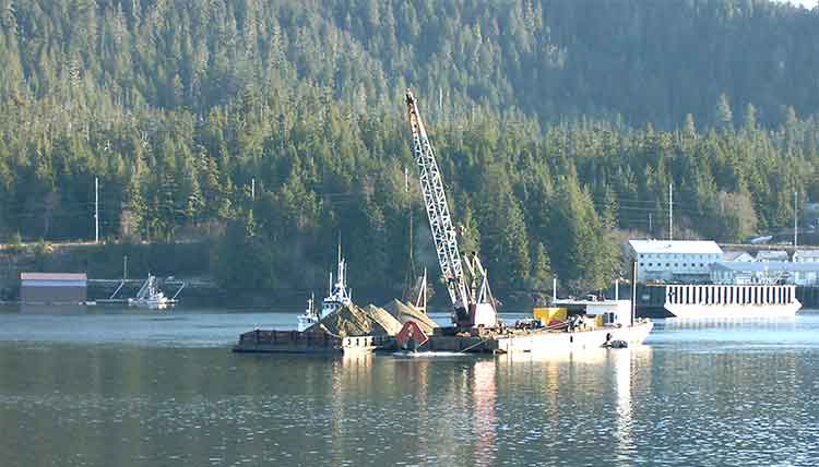
A dredging barge depositing clean sand (originally from Sechelt, BC) during capping operations at Ward Cove, Alaska in 2001. (EPA)

Two studies were carried out as part of the remediation at Ward Cove that do not appear to be contemplated at Clio Bay. The first looked at the “ability of the organic material to support the weight of 15 to 30 centimetres of sand.” Standard engineering equations used at other fill and capping sites were used as part of that study. A second study was carried out to determine the “minimum safety for a given slope,” which given the steep mountains that line Clio Bay, are likely to be factor in the deposit of marine clay. That study determined “For a silty fine sand and a factor of safety of 1.5, the maximum slope would be approximately 40 per cent.”

Those studies led to the conclusion that for the Ward Cove remediation project, the material to be placed on the fine organic sediment could not be gravel and course sand.”

That’s because the larger gravel and course sand “would tend to sink into the sediment and would not provide quality benethic (seabottom) habitat.”

The project decided to use “fine to medium sand with minimal fines.” It also concluded “Because of the very soft existing sediments and steep slopes at Ward Cove, the … material must be released slowly so that the settling velocity is low and bed impact minimized.”

That meant that the EPA had look for a source of quality sand that met their criterion. The sand was found at Construction Aggregates in Sechelt, BC, loaded on 10,000 tonne deck barges, tugged up the coast, unloaded onto land using a conveyor and stockpiled while more tests were done to determine how to deposit the sand on the sunken logs.

Sand bucket at Ward Cove
Dredging bucket modified to deposit sand during capping operations at Ward Cove, Alaska. (EPA)

Sand was placed on a smaller barge and taken to the deposit site. Initial tests were done with a mechanical dredge equipped with a clamshell bucket. The operator deposited the sand using “swaths” released from the bucket. To make it work properly, the bucket, as supplied by a manufacturer had to be modified by welding baffle plates to the bucket and lengthening the chains to insure consistent deposition of the sand. Two computers with special software called WINOPS, designed for dredging operations  “provided the operator and deck engineer the precise locations of the derrick barge position” in order to ensure precise deposition of the sand. WINOPS dredge positioning and guidance software. The WINOPS system made use of three differential global positioning receivers. One GPS receiver was located at the top of the derrick and provided the center positioning of the dredge bucket. Two fixed receivers, one near the starboard center spud and one near the center aft, provided the barge position and heading.

Although using marine clay is likely to produce different engineering challenges at Clio Bay, it is not currently clear that the project has contemplated the level of precision that was used at Ward Cove.

While KM LNG must find a way to dispose of the marine clay from the Bish Cove excavation site, there is a silver lining for the Haisla Nation’s aim of restoring both Clio Bay and the other 50 sites in their traditional territory, since the Kitimat Sand Hill would likely be a ready resource for any future projects.
Monitoring

The EPA considered the project finished in September 2001, and long term monitoring began, with major updates every five years in 2004 and 2009.

An EPA report on the 2004 review showed that the three sand-capped areas and one shallow natural recovery area (not sand-capped) had achieved biological recovery; three other natural recovery areas tested had not achieved biological recovery but were making significant progress.

The  2004 studies showed that benethic (sea bottom) communities in uncapped areas showed “species commonly found in areas where organic enrichment is low or declining.” adding “In three other natural recovery areas, benthic communities have not progressed as far toward recovery but are making significant progress.

By the time of the 2009 update, most of the old industrial infrastucture on land at Ward Cove had been demolished and the land area was slated for redevelopment. Many of the companies that had been there had either gone out of business or had declared bankruptcy and the land was taken over by the Ketchikan Gateway Borough,mostly through foreclosure.

The EPA declared that “The remedial action construction is complete, and the remedial action is an operating or ongoing remedial action.”

The 2009 report says that the project was successful in eliminating sediment toxicity. The area was then quickly being recolonized by a diverse bottom dwelling macroinvertebrate species and those species were spreading beyond the specific study areas, so recovery of Ward Cove is expected to continue.

However the 2004 report went on to say that “the achievement of stable benthic biological communities with balanced species composition in more than 75 percent of the area with documented coverage by wood residues on the bottom of Ward Cove” would happen within 40 years from the 2004 study.

The next review of Ward Cove is slated for August 2015.


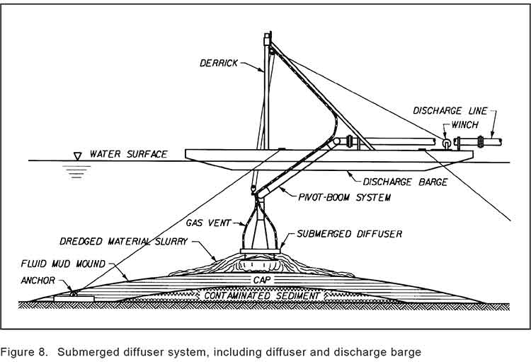
Sand capping
Diagram of a sand capping operation from a barge. (US Army Corps of Engineers)


Diagram of a sediment capping operation knowing as diffusion (US Army Corps of Engineers)


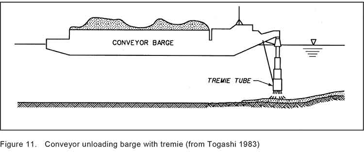
Termie
Diagram of a Japanese system called tremie that uses a hose system to deposit capping material on the seabed. (US Army Corps of Engineers)

[rps-include post=5057]

Chevron announces open house on Clio Bay, seeks input from stakeholders

Updates with open house location

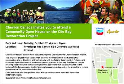
Chevron LogoChevron, the partner with Apache in the KM LNG (also known as Kitimat LNG) project at Bish Cove, said Sunday that the company will hold an open house in Kitimat on the controversial Clio Bay reclamation project.

Chevron says there will be a public open house at Riverlodge Tuesday, October 8 from 4 pm to 8 pm.

In an e-mail to politicians and local groups, including Douglas Channel Watch, Marc Douglas, a senior advisor for Chevron, based in Calgary, invited local stakeholders for a series of one hour meetings the same day at the KM LNG offices in City Centre.

Chevron Canada invites you to a meeting to discuss the Clio Bay Marine Life Restoration Project.
This proposed project would see Chevron excavate marine clay from the Kitimat LNG construction site at Bish Cove and work closely with the Federal Department of Fisheries and Oceans to deposit this natural material in specific locations in Clio Bay. The clay will cap-off decaying wood debris left by historic log booming operations that has accumulated on the bottom of Clio Bay, damaging the Bay’s natural ecosystem. A key goal of the project is to restore natural marine life populations in Clio Bay. Come and share your thoughts and ideas with us and learn more about this innovative restoration project.


Ad for open houseThere has been growing controversy over the Clio Bay project in recent weeks. Members of the Haisla Nation and residents of Kitimat were initially told that due to the large number of sunken logs at Clio Bay, that the area was deprived of oxygen, with limited sealife and that capping the logs with clay from Bish Cove would restore the ecosystem. However, beginning with a discussion at District of Kitimat Council on September 3, more people have been challenging the idea that Clio Bay needs restoration, with fishers posting photographs of recent catches on Facebook pages.

On Sept.3, Councillor Phil Germuth told Council:  “Those logs have actually created a woody reef, where like any other reef, an ecosystem is being sustained. So to say that those logs are suffocating the life out of Clio Bay doesn’t seem to have a lot of merit.”

At the time, Chevron told the media  that they had consulted with the Department of Fisheries and Oceans and  concluded that carefully placed clay would improve the ecosystem.

Special report: Clio Bay cleanup: Controversial, complicated and costly

[rps-include post=5057]

Kitimat in “horse race” with Australian LNG project Chevron says

Gorgon project in Australia
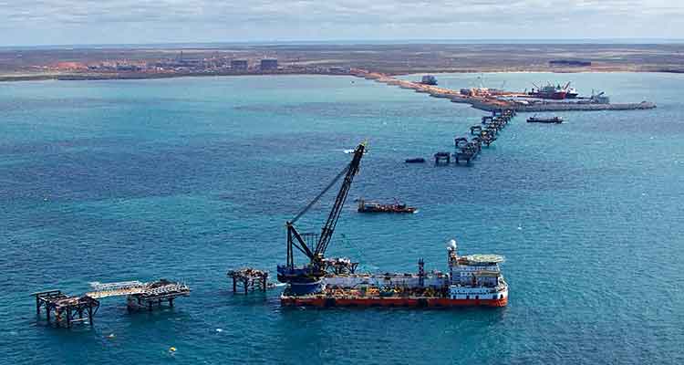
The Gorgon LNG project in Western Australia. Chevron says  Gorgon Project work continues to progress with the installation of the second of three amine absorbers, two condensate stabilization modules and a recycled gas compression module. (Chevron Australia)

Kitimat LNG is in a “horse race” with an LNG project in Western Australia–and at this point, according to the Australian media–Kitimat is winning, even though the Australian Gorgon project is much further ahead while the Kitimat LNG project at Bish Cove hasn’t really started.

The Australian reports come from the same conference call Chevron held with financial analysts last week, when the company said the final investment decision for Kitimat LNG has been postponed to 2014.

The Brisbane Times  is quoting Chevron as saying that expansion of the Gorgon “will be in direct competition with exports from North America, which have a cost advantage.”

Chevron has a 47.3 per cent stake in Gorgon. Shell which is developing its own project at Kitimat, LNG Canada, has a 25 per cent stake in Gorgon. ExxonMobil holds 25 per cent.

”In the case of Gorgon train four … we are happy to see both of them move forward,” Chevron vice-chairman George Kirkland told analysts late last week, referring to the competition with Kitimat. ”[There is] a bit of a horse race between them at this point.”

Shipping gas to north Asia from Canada is cheaper than exports from Australia, he said, although the challenge is to find markets for the gas. ”The development cost at Kitimat … may end up being less than in the case of Gorgon,” he said, which ”has the benefit of [being a] brownfield development on the plant side”.

”We’re going to offer volumes … and interest in the plant as a combination,” Mr Kirkland said of the Kitimat marketing plans. ”We think that’s a big advantage.

”Our goal is to maintain our … first-mover advantage … We have had some initial discussions with Asian buyers.”

The Gorgon project in the northwestern area of Western Australia. (Chevron Australia)

According to Wikipedia, the Gorgon area of Western Australia is the site for a number of liquified natural gas projects. The projects are off shore and close to the export terminals, much different from British Columbia where the gas fields are in the Peace River district in the northeast of the province.

Wikipedia says

The Gorgon field is centered about 130 kilometres (81 mi) off the north-west coast of Western Australia, where the water depth is approximately 200 metres (660 ft). Other fields in the group lie to the north, such as Jansz-Io, which covers an area of 2,000 square kilometres (770 sq mi), in a water depth of 1,300 metres (4,300 ft).

Chevron says

It is one of the world’s largest natural gas projects and the largest single resource development in Australia’s history.
The Gorgon Project is developing the Gorgon and Jansz-Io gas fields, located within the Greater Gorgon area, between 130 and 220 kilometres off the northwest coast of Western Australia.
It includes the construction of a 15.6 million tonne per annum (MTPA) liquefied natural gas (LNG) plant on Barrow Island and a domestic gas plant with the capacity to supply 300 terajoules of gas per day to Western Australia.
Gorgon LNG will be off loaded via a 2.1 kilometre long loading jetty for transport to international markets. The domestic gas will be piped to the Western Australian mainland.
The Gorgon joint venture is investing approximately $2 billion in the design and construction of the world’s largest commercial-scale CO2 injection facility to reduce the project’s overall greenhouse gas emissions by between 3.4 and 4.1 million tonnes per year. The Australian Government has committed $60 million to the Gorgon Carbon Dioxide Injection Project as part of the Low Emissions Technology Demonstration Fund.

Gorgon project wharf
A view of construction on the 2.1-km (1.3-mile ) LNG wharf with 24 caissons in place. (Chevron Australia)


In May, Reuters reported that the $52 billion Gorgon liquefied natural gas (LNG) development was 60 per cent complete. At the time, Reuters said Chevron planned to start engineering and design work for an expansion by the end of the year.

Parts of the Gorgon project are in an environmentally sensitive area, Barrow Island, which has been a nature reserve in Australia since 1910.

Wikipedia says

Barrow Island’s ecology. The island is a Class A nature reserve, and home to theflatback turtle (classified as a vulnerable species) and numerous other animals not found on the Australian mainland. Other concerns are related to the adequacy of quarantine procedures on Barrow Island to protect against the introduction of non-endemic species, and risks associated with geological sequestration of CO2.It was reported in November 2011 that native animals on Barrow Island had been accidentally killed daily with a known total of 1550 since construction began.

Chevron says

The Gorgon Project is being undertaken in accordance with strict environmental standards to preserve the island’s ecology.
Central to the Gorgon Project’s commitment to protect the conservation values of Barrow Island is the Quarantine Management System (QMS), which directs
the Project’s quarantine operations. The QMS is the largest non-government quarantine initiative in the world and was considered to be “likely world’s best practice” by the Western Australian Environmental Protection Authority. The Project’s gas processing facilities are being constructed within a 300 hectare ground disturbance limit, which represents 1.3 percent of Barrow Island’s uncleared land area.

Gorgon Project Overview Chevron document pdf

Gorgon-Progress Update August 2, 2013 pdf

Coast Guard plans to pump oil from sunken WWII transport in Grenville Channel

The Canadian Coast Guard says it will undertake “a significant environmental response operation” because more oil is leaking from the sunken Second World War United States Army Transport vessel, the Brigadier General M.G. Zalinski. 

The Coast Guard says that an operation known as “hot tapping” will be used to remove the oil from the Zalinski. Hot tapping was used recently to remove fuel from the sunken cruise liner Costa Concordia off Italy and the container ship Rena which broke up off New Zealand.

The Coast Guard says:

Hot tapping is a well-known and frequently used method of removing oil from the tanks of stricken vessels. Holes are carefully drilled into the side of the vessel to access fuel-tanks and then hot steam is pumped into the tanks. The steam increases the temperature of the oil and enables it to flow more easily. The oil is then pumped to the surface for safe disposal.

The procedure can be done with holes of very small sizes up to very large diameters. Hot tapping is used in both marine and land-based scenarios.


The red sections in the image above represent the fuel tanks of the Zalinski; the possible locations for hot tapping of the vessel. The yellow sections represent the cargo holds. (Canadian Coast Guard)

The Canadian Coast Guard says it “has engaged the Gitga’at First Nation and the Province of British Columbia to participate in the operation and maintain a presence at the wreck site” and will keep the Gitga’at First Nation informed of what is going on:

The Coast Guard recognizes that given their proximity to the Zalinski site and their interest in the oil recovery operation, the Gitga’at need to be informed on the progress of the operation and that they have important local knowledge and skill that will be beneficial to the operation.


Related:More oil leaking from sunken WWII US transport near Hartley Bay, Gitga’at warn

The Coast Guard says that environmental monitoring in January and March of 2013, discovered “further upwelling” of oil and added new patches to the sunken vessel.

The Coast Guard says: “Although the patches from 2012 and 2013 remain in place, early patches have begun to leak and the Canadian Coast Guard has determined that the structural integrity of the vessel is deteriorating.”

Brigadier General M.G. Zalinski
USAT Brigadier General M.G. Zalinski (Canadian Coast Guard)

The  USAT Brigadier General M.G. Zalinski was built in 1919 and served as a United States Army Transport vessel during the Second World War. It ran aground during a storm and sank in 1946 in the Grenville Channel about 100 kilometres south of Prince Rupert.

According to a Coast Guard News release, the wreck was “undetected” until the fall of 2003 in 34 metres of water near an underwater cliff about 20 metres from shore.

In September 2003, the United States Coast Guard Cutter Maple reported pollution in the Grenville Channel to the Canadian Coast Guard.

The CCGS Tanu  investigated the source of the pollution and collected oil samples, but, the news release says, the vessel remained elusive and undetected.

A month later, more oil pollution was spotted so the Canadian Coast Guard used a remotely operated underwater vehicle which located the Zalinski.

New pollution was reported in the channel in October 2003 by a commercial airline pilot and at this time the Coast Guard suspected that the source of the upwelling of oil was an old wreck.
In 2003 and 2004, the Canadian Coast Guard contracted divers to patch the vessel to prevent the leak of oil.

The Coast Guard says it regularly monitored the site with the help of Transport Canada’s National Aerial Surveillance Program. Local First Nations Groups also monitored the wreck site.
More oil was spotted in April 2012, and at that time, contract divers patched the Zalinski with an epoxy that hardens underwater.

The Coast Guard says new dive footage has shown that metal rivets that hold the hull’s plates are corroding and that the hull is buckling.

as the state of the vessel deteriorates, the Coast Guard has determined that to prevent any harm to the environment, a significant operation should be undertaken to remove the oil from the vessel. The Canadian Coast Guard will be the on-scene commander for the duration of the operation, directing the recovery and the removal of marine pollutants from the vessel and actively monitoring the operation.

The Canadian Coast Guard has also engaged the province of British Columbia and local First Nations groups to solicit their feedback on the operation. On July 26, 2013, Public Works and Government Services Canada posted two requests for proposal seeking a third-party to conduct the oil removal operation and oil spill response services to assist in the case that any oil leaks from the vessel as the operation progresses.

Map of Grenville Channel
Wreck sites for M.G. Zalinksi and Queen of the North (Canadian Coast Guard)

It is expected that the operation will begin in September 2013 and will conclude in December 2013. The Coast Guard says because the Grenville Channel is so narrow, some restrictions on vessel traffic in the Inland Passage will be needed.

The Grenville Channel is a narrow fjord-like waterway with significant tidal fluctuations and currents up to three knots. The shoreline is rocky and steep with little shoreline vegetation.
The Grenville Channel sees commercial fishing vessels, ferries, cruise ships, and pleasure craft transiting its waters on a regular basis, with increased frequency in the summer months. These waters, naturally shielded from stronger offshore winds and weather conditions, are the preferred route of many cruise ships.

The more mild sailing conditions and the stunning natural beauty of the area make the Grenville channel one of the scenic highlights of many marine travellers on Canada’s West Coast.


Joe Oliver makes flying visit, meets Haisla, snubs Kitimat (almost)

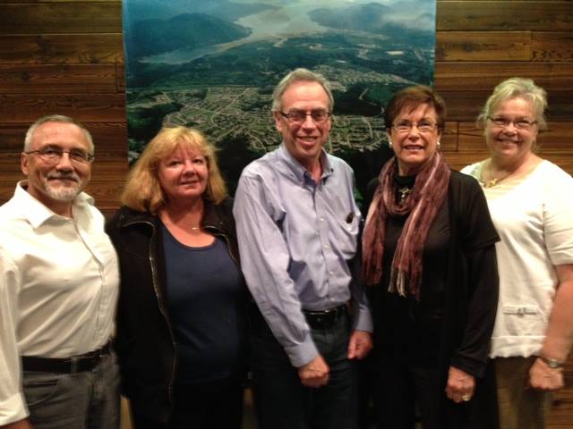
Natural Resources Minister Joe Oliver (centre) meets District of Kitimat Councillors, left to right, Rob Goffinet, Mary Murphy, Mayor Joanne Monaghan and Councillor Corrine Scott. (District of Kitimat)
Natural Resources Minister Joe Oliver (centre) meets District of Kitimat Councillors, left to right, Rob Goffinet, Mary Murphy, Mayor Joanne Monaghan and Corinne Scott. (District of Kitimat)

Natural Resources Minister Joe Oliver made a brief visit to the Kitimat area on Tuesday July 23, 2013, meeting Haisla Chief Counsellor Ellis Ross. In the original planning for the visit, Oliver was not scheduled to meet with District of Kitimat Council or other members of the community, snubbing Kitimat in only his second visit to the region since he was appointed minister after the 2011 federal election.

A half hour meeting with available members of the District of Kitimat Council was squeezed in only after intense lobbying from Mayor Joanne Monaghan.

The Natural Resources department public relations staff also chose to ignore (or exclude) local media, with the exception of the Northern Sentinel. Northwest Coast Energy News, Kitimat Daily, CFTK and CRFN were not informed and did not accompany Oliver on his hour long tour of Douglas Channel.

After the meeting, Natural Resources Canada issued a news release  saying that he had concluded “a successful visit to Kitimat,” hosted by the Haisla:

Minister Oliver discussed opportunities to increase First Nations’ participation in resource development and received a tour of the Douglas Channel hosted by Chief Councilor Ellis Ross.

“I am privileged to have been invited by the Haisla Nation to gain their perspective, listen to their concerns and discuss our plans for Responsible Resource Development and our initiatives to strengthen environmental protection,” said Minister Oliver. “Resource development presents a tremendous opportunity for First Nations groups like the Haisla. Our government has also been clear that development will only proceed if it is safe for the environment…”

“Responsible resource development has the potential to create significant new opportunities for Aboriginal peoples across Canada,” said Minister Oliver. “The Government will make every effort to ensure that…

Aboriginal peoples in Canada have the opportunity to share the benefits of energy resource development in the years ahead, while ensuring that projects are developed in a manner that has the highest regard for safety and the environment.”

“The safe and responsible diversification of our energy markets is a priority for the Government of Canada,” said Minister Oliver. “Our energy industry must remain competitive to ensure communities across Canada continue to benefit from our natural resource wealth.”

The Northern Sentinel reported that Oliver mainly concentrated on liquified natural gas development and tried to avoid questions about the Enbridge Northern Gateway project. Oliver repeated the federal government’s position on safety outlining the programs announced last march to expand pipeline expansion and increase penalties for safety violations.

On LNG, Oliver told the Sentinel, “These are decisions made by the private sector, it’s not us telling us don’t do this project…they’re going to figure that out themselves,” he said.

On the Enbridge Northern Gateway Pipelines Project, Oliver told the Sentinel, “We have a very strong interest in seeing the markets diversify, and that includes moving oil to Asia,” he said. “However, we’re not going to stomp over the regulatory process. It’s subject to regulatory review, the joint review panel will be coming to its conclusion this December. We’re waiting for what they have to say…I know people have a view of what our opinion is but we don’t offer an opinion before we hear from the regulator.”

He added that once the review is done, “At that point we’ll know more because they will have a done a comprehensive, scientific audit.”

Councillor Mary Murphy told Northwest Coast Energy News that she was told by a Haisla friend early Tuesday morning that Oliver was coming to visit Kitamaat Village and immediately informed Mayor Joanne Monaghan.

Monaghan said, “I called his office in Ottawa and said I wanted a meeting  as well  seeing he was here. After an all day back and forth until three o’clock he said he would come at four for half an hour.”

Councillor Corinne Scott said. “As none of us were aware of the Minister being in Kitimat, we scrambled to have Mary, Rob, the Mayor and I available to meet with him, along with [DOK Chief Admnistrative Officer] Ron [Poole] and [Economic Development Officer] Rose Klukas.”

Councillors Mario Feldhoff, Phil Germuth and Edward Empinado were unable to attend because they working at the time and could not get away with such short notice.  Sources tell Northwest Coast Energy News that even pro-development members of the local business community were not informed about Oliver’s visit.

Murphy described the meeting “as very beneficial to us.”  A couple of other sources, familiar with accounts of the meeting, however, both told Northwest Coast Energy News there was barely enough time after formalities to ask questions of the minister before he dashed out the door for the airport.

Oliver last visited the region in March, to make an announcement in Terrace. At that time he did not visit Kitimat.


Kinder Morgan files last minute objection to Joint Review’s proposed conditions for Northern Gateway

Kinder Morgan logoKinder Morgan has filed a last minute objection to the Northern Gateway Joint Review Panel’s preliminary conditions for the Enbridge project.

One of the objections from Kinder Morgan is the provision in the JRP’s proposed Gateway conditions for “purpose built tugs” to escort tankers (a measure that Enbridge has proposed for the Gateway project). Another provision Kinder Morgan objects to is “secondary containment facilities at marine terminals” likely to become an issue if the Vancouver terminal is expanded by Kinder Morgan.

Overall, Kinder Morgan warns that if the JRP imposes some of the proposed conditions on the Northern Gateway, it could adversely affect future pipeline projects in British Columbia.

As well, Kinder Morgan, it appears, is already concerned that if the proposed oversight of Northern Gateway goes ahead, the Kinder Morgan plan to twin the pipeline from Alberta to Vancouver and expand terminal operations in Vancouver could face ongoing scrutiny and possible delays.

The Kinder Morgan document, from the company’s Calgary lawyer, Shawn Denstedt, of Osler, Hoskins and Harcourt, filed May 31, appeared among all the final arguments filed on Friday by intervenors and governments to the Joint Review Panel on Northern Gateway.

Kinder Morgan’s letter to the JRP comes long after the final deadline for such comments.

Kinder Morgan is a registered intervenor in the Northern Gateway hearings, but has only filed four previous documents during the entire multi-year process. The company does not appear on the list of intervenors scheduled to appear for oral final arguments in Terrace beginning on June 17.

On April 12, 2013, the JRP issued a preliminary list of 199 conditions for the planning, construction and operation of the Northern Gateway project.

Now Kinder Morgan is worried. Denstedt’s letter notes:

we believe a number of the proposed conditions may have a material impact on pipeline and infrastructure development in Canada and consideration should be given to the conditions from this perspective.

Diplomatically, Denstedt goes on to tell the panel:

Our comments are intended to assist the JRP in understanding the potential outcomes of the proposed conditions if they become generally applicable to industry.

Commercial considerations

Under what Detstadt calls “Commercial considerations”, Kinder Morgan says “we observe that several of the proposed conditions are likely to affect the manner and risks involved in procuring pipeline facilities and services.

The list points to

Three layer composite coating or high performance composite coating is required for the entire pipeline although other pipeline coatings are commonly used in the pipeline industry depending upon ground conditions encountered
.
Complementary leak detection systems must be identified that can be practically deployed over extended distances of pipeline.

The construction of purpose-built tugs involves significant cost and lead time

A volume is prescribed for the secondary containment facilities at the marine terminal without reference to existing codes.

The letter goes on to say that if the conditions proposed by the JRP for the Northern Gateway come into effect, in Kinder Morgan’s opinion, it could adversely affect other pipeline projects in the future.

If broadly applied to industry, such conditions may limit the ability of pipeline companies to obtain competitive quotes because there are few sources of the required materials or services. The effect of conditions that require the use of a particular material or service may be to grant commercial benefits to certain suppliers through the regulatory process beyond the requirements of existing codes. Since several export pipelines are currently proposed, there will be a heightened demand for labour and materials in the coming years. The commercial effect of conditions that may exacerbate shortages of labour and materials should be a relevant consideration for the JRP.

Timing


One of Kinder Morgan’s objections is to the timing the JRP proposes for the Northern Gateway project if it applies to other pipelines.

Several of the proposed conditions contain NEB approval requirements and filings deadlines several years prior to operations. For example, plans related to the marine terminal and research programs must be filed for NEB approval three years prior to operations.

We are concerned that requiring reports to be filed for approval several years before operations can create significant schedule risks for infrastructure development projects. For example, a project with a two year construction schedule could take three years to complete with such conditions. Any changes to the construction schedule and anticipated date of operations would affect the filing deadline. Project proponents need sufficient schedule certainty in order to plan major expenditures on labour and materials.

To mitigate such risks, it is relevant for regulators to consider whether the filing deadlines and approval requirements prescribed in conditions could materially alter a project’s schedule. Filing deadlines should be set at a reasonable time before operations in order to minimize the risk that such deadlines materially affect the critical path for a project.

Many of the conditions require NEB approval, and in some cases the participation of other parties in the approval process, in order to be satisfied. Fulfillment of those conditions will require additional time, a Board process and potentially litigation. For example, certain reports must be filed with the NEB for approval prior to commencing construction activities. Other conditions require reports to be filed for approval by the NEB prior to construction with a summary of how concerns from other government agencies and Aboriginal groups were addressed.

So Kinder Morgan says:

In our view, conditions that require subsequent board approvals and that attract the potential for additional regulatory processes should be the exception and not a new standard or norm. There must be clear, well understood rationales given as to why additional approvals are in the public interest.

And so Kinder Morgan asks:

As an alternative, the NEB may utilize its existing powers and processes to ensure that when filings are made to satisfy imposed conditions an additional approval process is not required.

Overall the company sees the rules for Northern Gateway as a step back to the days before deregulation.

A number of the conditions may be interpreted as reflecting a return to a prescriptive approach to regulation. These conditions prescribe detailed audit requirements instead of setting a goal oriented approach to allow the proponent flexibility in mitigating any adverse effects. Such conditions tend to focus on operational aspects that are covered by existing codes and regulations rather than setting goals for the proponent to mitigate any significant adverse effects.

Denstedt, again diplomatically, concludes by saying:

Kinder Morgan wishes to thank the JRP for the opportunity to present these high level perspectives regarding its proposed conditions. Our comments are intended to ensure that the wider implications of the proposed conditions on the pipeline industry and infrastructure development are given appropriate consideration in the deliberations and final recommendations of the JRP.

Kinder Morgan letter to JRP

SFU study says spill hazards for Kitimat from tankers and pipelines much greater than Enbridge estimate

A study by two scholars at Simon Fraser University says that the Enbridge Northern Gateway project is much more hazardous to Kitimat harbour, Douglas Channel and the BC Coast than Enbridge has told the Joint Review Panel.

The study by Dr. Thomas Gunton, director of the School of Resource and Environmental Management at SFU and Phd student Sean Broadbent, released Thursday May 2, 2013 says there are major methodological flaws in the way Enbridge has analyzed the risk of a potential oil spill from the bitumen and condensate tankers that would be loaded (bitumen) or unloaded (condensate) at the proposed terminal at Kitimat.

Enbridge Northern Gateway responded a few hours after the release of the SFU study with a statement of its own attacking the methedology used by the two SFU scholars and also calling into question their motivation since Gunton has worked for Coastal First Nations on their concerns about the tanker traffic.

Combination of events

One crucial factor stands out from the Gunton and Broadbent study (and one which should be confirmed by independent analysis). The two say that Enbridge, in its risk and safety studies for the Northern Gateway project and the associated tanker traffic, consistently failed to consider the possibility of a combination of circumstances that could lead to either a minor or a major incident.

Up until now, critics of the Northern Gateway project have often acknowledged that Enbridge’s risk analysis is robust but has consistently failed to take into consideration the possibilty of human error.

As most accidents and disasters happen not due to one technical event, or a single human error, the SFU finding that Enbridge hasn’t taken into consideration a series of cascading events is a signficant criticism.

Overall the SFU study says there could be a tanker spill every 10 years, not once in 250 years, as calculated by Enbridge.

It also says there could be 776 oil and condensate spills from pipelines over 50 years, not 25 spills over 50 years as projected by Enbridge. (And the life of the project is estimated at just 30 years, raising the question of why the 50 year figure was chosen)

Enbridge track record

The study also bases its analysis of the possibility of a spill not on Enbridge’s estimates before the Joint Review Panel but on the company’s actual track record of pipeline spllls and incidents and concludes that there could be between one and 16 spills (not necessarily major) each year along the Northern Gateway pipeline.


Findings for Kitimat

Among the key findings for Kitimat from the SFU study are:

  • Enbridge said the possibility of tanker spill was 11.3 to 47.5 per cent over the 30 year life of project. The SFU study says the possibility of a spill within the 30 years is 99.9 per cent.
  • The SFU study says it is likely there will be a small spill at the Kitimat Enbridge terminal every two years.
  • The SFU study estimates that there will be eight tanker transits each week on Douglas Channel if the Northern Gateway project goes ahead and more if it is expanded.  (This, of course, does not include LNG tankers or regular traffic of bulk carriers and tankers for Rio Tinto Alcan)
  • The SFU study says that while Endridge did study maneuverability of tankers, it paid little attention to stopping distance required for AfraMax, SuezMax tankers and Very Large Crude Carriers.
  • The SFU study says Enbridge inflated effectiveness of the proposed tethered tugs and maintains the company did not study ports and operations that use tethered tugs now to see how effective tethering is.
  • The SFU says Enbridge’s risk analysis covered just 233 nautical miles of the British Columbia coast, where as it should have covered entire tanker route both to Asia and California, raising the possibility of a tanker disaster outside British Columbia that would be tied to the Kitimat operation.
  • Based on data on tanker traffic in Valdez, Alaska, from 1978 to 2008, the SFU study estimates probability of a 1,000 barrel spill in Douglas Channel at 98.1 per cent and a 10,000 barrel spill at 74.2 per cent over 30 year Gateway life. The Valdez figures account for introduction of double hulls after Exxon Valdez spill in 1989 and notes that spill frequency is much lower since the introduction of double hulled tankers.
  • According to a study by Worley Parsons for Enbridge in 2012, the Kitimat River is the most likely area affected by an unconstrained rupture due to geohazards in the region. According to the Worley Parsons study, geohazards represent the most significant threat to the Northern Gateway pipeline system.

Flawed studies

The SFU scholars list a series of what they say are major methological or analytic flaws in the information that Enbridge has presented to the Joint Review Panel, concluding that “Enbridge significantly understates the risk of of spills from the Northern Gatway.

Enbridge’s spill risk analysis contains 28 major deficiencies. As a result of these deficiencies, Enbridge underestimates the risk of the ENGP by a significant margin.
Some of the key deficiencies include:

  • Failure to present the probabilities of spills over the operating life of the ENGP
  • Failure to evaluate spill risks outside the narrowly defined BC study area
  • Reliance on LRFP data that significantly underreport tanker incidents by between 38 and 96%.
  • Failure to include the expansion capacity shipment volumes in the analysis
  • Failure to provide confidence ranges of the estimates
  • Failure to provide adequate sensitivity analysis
  • Failure to justify the impact of proposed mitigation measures on spill likelihood
  • Potential double counting of mitigation measures
  • Failure to provide an overall estimate of spill likelihood for the entire ENGP
  • Failure to disclose information and data supporting key assumptions that were used to reduce spill risk estimates
  • Failure to use other well accepted risk models such as the US OSRA model


SFU reports that Enbridge provides separate estimates of the likelihood of spills for each of the three major components of the project:

      • tanker operations,
      • terminal operations,
      • the oil and condensate pipelines.

The SFU scholars say Enbridge does not combine the separate estimates to provide an overall estimate of the probability of spills for the entire project and therefore does not provide sufficient information to determine the likelihood of adverse environmental effects……

It notes that “forecasting spill risk is challenging due to the many variables impacting risk and the uncertainties in forecasting future developments affecting risk. To improve the accuracy of risk assessment, international best practices have been developed.”

Part of the problem for Enbridge may be that when the company appeared before the Joint Review Panel it has repeatedly said that will complete studies long after approval (if the project is approved), leaving large gaps in any risk analysis.

The SFU study may have one example of this when it says Enbridge did not complete any sensitivity analysis for condensate spills at Kitimat Terminal or the condensate pipeline.

Enbridge response

Enbridge responded by saying

Our experts have identified a number of omissions, flawed assumptions and modeling errors in the study and have serious concerns with its conclusions:
The spill probability numbers are inflated: The author uses oil throughput volumes that are nearly 40 per cent higher than those applied for in this project which also inflates the number of tanker transits using these inflated volumes
The pipeline failure frequency methodology adopted by Mr. Gunton is flawed, and does not approximate what would be deemed a best practices approach to the scientific risk analysis of a modern pipeline system
Mr. Gunton based his failure frequency analysis on a small subset of historical failure incident data. Why would he limit the source of his data to two pipelines with incidents not reflective of the industry experience and not reflective of the new technology proposed for Northern Gateway?
The study results are not borne out by real world tanker spill statistics. Based on Mr. Gunton’s estimates we should expect 21 to 77 large tanker spills every year worldwide while in reality after 2000 it has been below 3 per year and in 2012 there were zero.

Most of Enbridge’s rebuttal is a personal attack on Gunton, noting

We are very concerned about the misleading report released by Mr. Gunton, who was a witness for the Coastal First Nations organization during the Northern Gateway Joint Review Panel process.
Mr. Gunton should have made his study available to the JRP process, the most thorough review of a pipeline that’s ever taken place in Canada. All of Northern Gateway’s conclusions have been subject to peer review, information requests and questioning by intervenors and the Joint Review Panel.

In response, Gunton told the Globe and Mail “the report took over a year to complete and it was not ready in time to be submitted as evidence before the federal Joint Review Panel which is now examining the proposed pipeline.”

Enbridge’s statement also ignores the fact under the arcane rules of evidence, any study such as  the  one from Simon Fraser had to be submitted to the JRP early in the process, while evidence was still being submitted.

The recent ruling by the JRP for closing arguments also precludes anyone using material that was not entered into evidence during the actual hearings.

That means that the SFU study will be ignored in the final round of the Joint Review Panel, which can only increase the disillusionment and distrust of the process that is already common throughout northwest British Columbia.

“No need to scare people” about tanker disasters, Transport Minister tells Commons

“There is no need to scare people,” about tankers, Transport Minister Denis Lebel told the House of Commons on Thursday, March 28.

Lebel was answering a question from Skeena Bulkley Valley MP and NDP House Leader Nathan Cullen.

The official transcript from Hansard records Cullen’s question about the federal government’s unexpected declaration that Kitimat would become a public port.

Mr. Speaker, last week, in their panic to ram a bitumen pipeline through to British Columbia’s north coast, the Conservatives simply decreed that they would take over the Port of Kitimat. Rather than picking up the phone and talking with the local council or the Haisla Nation, the government parachuted in a minister from Toronto to make the announcement. There was no consultation, no respect, just bulldozers.
We see again the fundamental disrespect the government has for first nations here today. Now the Conservatives are scrambling, saying that they will consult after they have clearly made up their minds, the exact approach they take on the pipeline. When will the government start to respect the people of the northwest?

Lebel replied in French, and as is usual in Question Period did not answer Cullen’s question.

The official translation in Hansard reads.

Mr. Speaker, last week we announced the creation of an expert panel. These people will work together to think of how to improve things.
We have a very good system for dealing with oil spills. We will continue to move forward and keep everyone safe.
Canada has not had any major oil spills in its history. There is no need to scare people. We will continue to work on measures.
I thank all members of the panel led by Mr. Houston for their ability to find solutions.

This Youtube video shows Cullen’s question and Lebel’s response. The live translation is a little different, but the effect is the same.


Cullen later issued a news release commenting

Cullen’s question came on the heels of reports that neither Kitimat Council nor the Haisla Nation were consulted in advance of the federal government’s decision to take over the Kitimat port. The move represents an apparent ongoing tendency by the Conservative federal government to offer consultation with communities and First Nations, but only after they’ve already made their decision.

Cullen later reflected that, regardless of one’s position on the Northern Gateway pipeline, open and prior consultation is crucial to fostering good governance and the trust of the general public. By contrast, said Cullen, “the Conservatives are writing the book on how to ignore communities and First Nations, and damage public faith. This is just the latest chapter.”

Denis Lebel represents that land locked Quebec riding of  Roberval—Lac-Saint-Jean. The riding does have Lac St. Jean which is described in Wikipedia as

a large, relatively shallow lake in south-central Quebec, Canada, in the Laurentian Highlands. It is situated 206 kilometres north of the Saint Lawrence River, into which it drains via the Saguenay River. It covers an area of 1,053 km2 (407 sq mi), and is 63.1 m (207 ft) at its deepest point.

It is unlikely there will ever be a Very Large Crude Carrier on Lac St. Jean.

In its earliest statements the Harper Conservatives were careful to say that there had never been a tanker disaster on the west coast. Now, in its Orwellian fashion, the government is now saying “Canada has not had any major oil spills in its history.”

That statement, of course, ignores the Arrow tanker disaster off  Chedabucto Bay, Nova Scotia on  February 4, 1970, which the Environment Canada website, (as of April 1, 2013), describes this way

the calamity had reached catastrophic proportions. Out of the 375 statute miles of shoreline in the Bay area, 190 miles had been contaminated in varying degrees.

The Maritime Musem of the Atlantic wreck site describes a double barreled disaster where the oil was transferred to the Irving Whale, which later sank

There is also this report from a student at St Francis Xavier university.

 Related:

Analysis: The Harper government’s week of history-making blunders

Coastal First Nations launch election commercial with Exxon Valdez radio call

Coastal First Nations have launched a commercial aimed at the British Columbia electorate, using the call from the Exxon Valedez to US Coast Guard Valdez traffic control saying that the tanker had run aground.


The commercial makes the connection between the Exxon Valdez disaster and the possibility of a tanker disaster on the British Columbia coast if the Enbridge Northern Gateway project goes ahead.

According to the Vancouver Sun, Paul Simon personally approved the use of the song Sounds of Silence in the commercial.

The BC New Democrats, who are leading the polls have said they oppose Northern Gateway. The ruling BC Liberals have set out five conditions that must be met if the project is to go ahead.

Oliver confirms Kitimat to become a public port

Joe Oliver
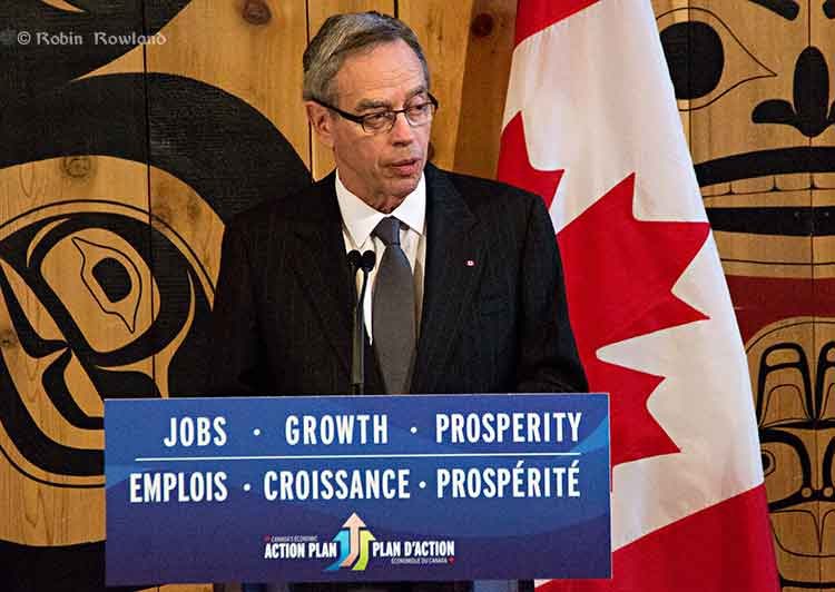
Minister of Natural Resources Joe Oliver answers a reporter’s question during a news conference in Terrace, March 19, 2013 (Robin Rowland)

Joe Oliver, the Minister of Natural Resources, has confirmed that the federal government intends to make Kitimat a public port.

Oliver was in Terrace, March 19, 2013, to announce the appointment of Vancouver lawyer Douglas Eyford as “Special Federal Representative on West Coast Energy Infrastructure.” Eyford’s job will be to “engage aboriginal communities in British Columbia and Alberta that are most likely to have an interest in West Coast energy infrastructure.”

Oliver was asked to confirm statements on the Transport Canada website that Kitimat would become a public port.

Oliver replied: “The news release was accurate. What the purpose is to make sure that the absolute highest standards of marine safety apply in the port of Kitimat. And we have as I announced yesterday and I had spoken about before at the port of Vancouver we have an extremely robust marine safety regime in place but we want to make sure that as resource development continues and as technology improves, we are at the world class level. As I also mentioned there has never been off the coast of British Columbia a major tanker spill and we want to keep that perfect record.”

No visit to Kitimat

Oliver was also asked if he intended to visit Kitimat during his visit to the northwest (Kitimat is a 40 minute drive from Terrace).  Oliver replied, “Not in this particular visit, I have to get back [to Ottawa] There’s a budget coming and I have to be in the House for that but I certainly expect to be going up there.”

The federal budget will be released on Thursday.

At Monday’s meeting of District of Kitimat council, some members quietly expressed frustration, to say the least, that Oliver, the man responsible for pushing the Northern Gateway pipeline through British Columbia to Kitimat had not bothered to include the town in his visit to the northwest.

Members of the District of Kitimat council, which on paper at least, is responsible for the port of Kitimat (even though it is really run by Rio Tinto Alcan) also expressed frustration that no one in Ottawa gave the council advance notice of the government decision to take the port public.

Asked for comment on Oliver’s statement, Rio Tinto Alcan officials in Kitimat also seemed unaware of the government announcement and promised a statement in the near future.

Oliver’s announcement in Vancouver Monday about a “world class” marine safety system and today’s announcement about the appointment of Douglas Eyford, appear to be a campaign by the Harper government to establish a stake in the middle ground in the pipeline debates, in hopes of undermining the opponents of the projects.

Skeena Bulkley Valley MP Nathan Cullen, in a news release, expressed reservations about Eyford’s appointment.

“The primary concern with the appointment, Cullen said, is that Mr. Eyford will report to the Prime Minister, not to Parliament or the public. “So, if Mr. Eyford’s report is in any way unfavourable to the Conservative pipeline agenda, what assurances do we have that his report will make its way into the public eye?

“It is also unclear how the appointment would affect Eyford’s work as the chief government negotiator for the federal government’s comprehensive land claims process, and what kind of effect his absence will have on that process.”