The immune system genes that protected north coast First Nations from possibly dangerous local pathogens thousands of years ago likely increased their vulnerability to European diseases in the nineteenth century, resulting in the disastrous population crash, a new genetic study has discovered.
The study which included members of the Lax Kw’alaams and Metlakatla First Nations at Prince Rupert “opens a new window on the catastrophic consequences of European colonization for indigenous peoples in that part of the world,” the study authors said in a news release.
The study, published today in Nature Communications, looked at the genomes of 25 individuals who lived 1,000 to 6,000 years ago in what the study calls PRH—the Prince Rupert Harbour region– and 25 of their descendants who still live in the region today.
“This is the first genome-wide study – where we have population-level data, not just a few individuals – that spans 6,000 years,” said University of Illinois anthropology professor Ripan Malhi, who co-led the new research with former graduate student John Lindo (now a postdoctoral researcher at the University of Chicago) and Pennsylvania State University biology professor Michael DeGiorgio. Both studies were carried out with the consent and cooperation of the Coastal Tsimshian people.
The new study analyzes the “exome,” the entire collection of genes that contribute to a person’s traits.
The ruins of a Haida longhouse at Tanu. Smallpox and other diseases brought a catastrophic population crash among coastal First Nations in the nineteenth century. (Robin Rowland/Northwest Coast Energy News)
“Oral traditions and archaeological evidence to date have shown that there has been continuous aboriginal occupation of this region for more than 9,000 years. This study adds another layer of scientific data linking the actual ancestral human remains to their modern descendants through their DNA over a span of 6,000 years,” said Barbara Petzelt, a co-author of the study and a liaison to the Metlakatla community. “It’s exciting to see how this tool of DNA science adds to the larger picture of Coast Tsimshian pre- and post-contact history – without the taint of historic European observer bias.”
In the new study, the team found that variants of an immune-related gene that were beneficial to many of those living in the region before European contact proved disadvantageous once the Europeans arrived.
The genes, the human leukocyte antigen gene family, known as HLA, helps the body recognize and respond to pathogens, or disease causing bacteria and viruses.
The authors say the “the immunological history of the indigenous people of the Americas is undoubtedly complex.”
As people came to the American continents about 15,000 to 20,000 years ago “indigenous people adapted to local pathogens.”
Statistical analyses revealed that the ancient genes were under “positive selection” before European contact. Natural selection meant that those ancient people with genetic resistance to those local diseases had an advantage that resulted in the genes becoming part of the population.
But the study indicates “those adaptations would have proven useful in ancient times but not necessarily after European colonialists altered the environment with their pathogens, some of which may have been novel. Existing genetic variation as a result of adaptation before European contact could thus have contributed to the indigenous population decline after European contact.”
The “positive selection” genes found in the remains of ancient members of the Coast Tsimshian people, has been replaced by another gene among the modern descendants that “has been associated with a variety of colonization-era infectious diseases, including measles and tuberculosis, and with the adaptive immune response to the vaccinia virus, which is an attenuated form of smallpox,” the authors wrote.
One of the genes is “64 percent less common today among the Coast Tsimshian people than it was before original European contact, which is a dramatic decline,” Lindo said.
The modern Coast Tsimshian show a “reduction in ‘effective population size’ of 57 per cent,” the researchers reported.
“’Effective population size’ is a population genetic concept that is different from what we normally think of with census population size,” Malhi said in an e-mail to Northwest Coast Energy News. “It basically means that there was a large drop in genetic diversity after European contact that could have been due to disease, warfare or other things that would result in this large population decline.”
The dramatic die-off occurred roughly 175 years ago, about the time that European diseases were sweeping through the First Nations of British Columbia.
While some members of the Coast Tsimshian community have intermarried with people of European descent over the past 175 years, the genetic changes cannot be solely attributed to what geneticists call “admixture.” The timing coincides with the documented smallpox epidemics of the 19th Century and historical reports of large-scale population declines. A majority of the “European admixture in the population likely occurred after the epidemics,” the study says.
To guard against what the study called “false positives” the genomes were also compared to individuals in the 1,000 Genome Project including 25 Han Chinese from Beijing as well as other indigenous peoples in the Americas including the Maya, the Suruí do Pará people of Brazil and a sample of Anzick DNA from the 12,000 year old remains of a child found buried in Montana.
“First Nations history mainly consists of oral stories passed from generation to generation. Our oral history tells of the deaths of a large percentage of our population by diseases from the European settlers.
“Smallpox, for our area, was particularly catastrophic,” said Jocelynn Mitchell, a Metlakatla co-author on the study. “We are pleased to have scientific evidence that corroborates our oral history. As technology continues to advance, we expect that science will continue to agree with the stories of our ancestors.”
The same vulnerability for smallpox, measles and tuberculous likely also contributed to the vulnerability to influenza, Malhi told Northwest Coast Energy News “It is important to note that any of these infectious diseases (measles, tuberculosis, smallpox, flu) could have resulted in the patterns that we are seeing. We just provided a few possibilities but not all possibilities.”
The study says the project was made possible through the active collaboration of the Metlakatla and Lax Kw’alaams First Nations.
The first collaborative DNA study began in 2007 and 2008. The scientists visited the communities each year “to report the most recent DNA results and obtain feedback on the results.”
“The two communities agreed to allow DNA analysis of ancestral individuals recovered from archaeological sites in the region and currently housed at the Canadian Museum of History. During and after community visits and extensive consultation, a research protocol and informed consent documents—agreed on by the indigenous communities and researchers—was approved by the University of Illinois Institutional Review Board. All individuals signed an informed consent document.”
These results were reported to the community and the scientists continue to visit the First Nations to report on this and related studies.
The study is titled “A time transect of exomes from a Native American population before and after European contact” and appeared in the Nov. 15, 2016, edition of Nature Communications.
UPDATED with comments from District of Kitimat, Terrace and the Gitga’at Nation
A preliminary seismic hazard assessment by Natural Resources Canada has identified possible earthquake scenarios for the Douglas Channel near Hartley Bay, Terrace and Bella Bella.
The same studies indicate that while Kitimat may not be directly in a seismic zone prolonged earthquakes cause some damage in Kitimat depending on the earthquake and the condition of the soil in certain parts of the District. One model scenario says that in the event of a magnitude 8.0 earthquake off the west coast of Haida Gwaii, given certain soil conditions, there might actually be more damage in Kitimat than on the islands.
Susceptibility to landslides
That assessment, part of the overall the study by the Geological Survey of Canada indicates that the north coast of British Columbia from Prince Rupert to Bella Bella is likely face to “seismically induced ground failure”– mostly landslides.
Overall, the report says that on a scale of 1 to 6 (6 representing the highest
susceptibility), the majority of the west coast of BC “exhibits landslide susceptibility values of 5 to 6, which is significantly higher than the rest of Canada.”
Geological Survey of Canada map showing parts of Canada that are prone to landslides. The BC North Coast study area is outlined by the rectangle. (Geological Survey of Canada)
In British Columbia the landslides are most likely to be triggered by delayed melting of the annual snow pack, heavy rains, bank erosion and site loading and caused long-lasting damning of the river causing “damage to pipelines, rail, and forestry, as well as fish habitats.”
So far no recent landslides along the northern British Columbia coast are known to be caused by earthquakes, the reports say “the existence of numerous landslides strengthens the likelihood of seismically induced ground failures… due to the high levels of seismicity….it is expected that the increased likelihood of strong ground shaking (with long durations) will increase the landslide susceptibility.”
New studies
It was only after the 2012 Haida Gwaii earthquake and with what the Geological Survey of Canada calls “a growing number of on-going and planned infrastructure projects, BC’s north coast is emerging as a region of high strategic importance to Canada’s economy,” that studies began in area where “there has been minimal research to understand earthquake hazards.”
Now that studies have begun the Geological Survey has given the region its own new acronym BCNC (BC North Coast). Haida Gwaii is not part of BCNC, although earthquakes on those islands would likely impact the coast.
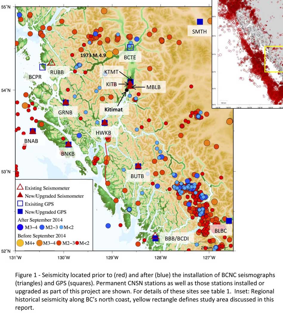
A Geological Survey of Canada map showing the BC North Coast region with earthquakes identified prior to and during recent studies. (Geological Survey of Canada)
The Geological Survey says that historically “the BCNC has been seismically quiescent.” As a result “seismic monitoring and research related to the BCNC has been minimal.” That meant while larger earthquakes were “felt and recorded,” the configuration of the Canadian National Seismograph Network did not allow earthquakes less than approximately magnitude 2.1 to be monitored in northern BC.
Now the Geological Survey is looking at “long-term, continuous monitoring of micro seismicity, combined with geodetic and paleo seismic techniques” that could be used to study at the possibility of large earthquakes, including a possible fault on the lower Douglas Channel.
Since the studies began in August 2014, the Geological Survey identified 145 earthquakes within the study area, many too small to be felt since they are less than magnitude 2.0. Those earthquakes, however, were picked up by the new and improved instrumentation used by the earthquake monitors.
The two reports one on “seismic hazards” and the second on “geohazards” says five “temporary seismonitors” (download reports from links below) were installed within the BCNC while some older stations were upgraded, saying, “It is expected that these new stations will be aid in locating small earthquakes” that were not previously detected by the existing network. The Geological Survey also installed ground movement monitoring GPS units along the coast.
The use of the term “temporary” raises the question about how much ongoing monitoring is planned.
The study also notes that the current data is not included in the seismic standards in the current National Building Code of Canada, which in turn is based on the Natural Resources Canada Seismic Hazard Map. That may mean that municipalities in the BC North Coast region, in the future, as the seismic studies continue, may have to consider updating building codes, especially in areas of “softer soils” as opposed to harder rock.
“Fault-like structure” on Douglas Channel
Detail of a map from the Geological Survey of Canada where the red line shows the 60 kilometre possible (still unconfirmed) fault line running from Gribbell Island to Princess Royal Island (Geological Survey of Canada)
Over the years some small earthquakes have also been recorded on what the Geological Survey calls the “recently mapped fault-like structure” on Douglas Channel which was discovered in 2012. The survey is still calling it “fault-like” because it has not yet been confirmed as an active fault. A new map in the study shows that the “fault” runs from the southern tip of Gribbell Island, down the centre of Whale Channel east of Gil Island and then along the western coast of Princess Royal Island.
The study identified “a small, unfelt swarm of earthquakes between magnitude 1.7 and 2.0 between September 13 and 14, 2010 near Gil Island.”
There is also the previously identified ancient Grenville Channel Fault (ancient and believed inactive because it dates from the Cretaceous, the age of the dinosaurs) that runs from along Grenville Channel from Porcher Island in the north to Klemtu in the south which has experienced small earthquakes.
The report says geological studies of the Douglas Channel “fault-like structure” are a priority because, “Should this structure be determined to be an active fault, it would pose significant risk of earthquake-triggered landslides (and subsequent tsunami) from the susceptible Douglas Channel hill slopes.”
Clay and sand in Kitimat
The report also calls for more studies the local geology and soil conditions in the Kitimat Valley. A study back in 1984 by John Clague of Simon Fraser University showed that as the glaciers retreated during the last Ice Age there were “periods of stagnation” resulting in sediments that are thicker than other regions of British Columbia, Clague reported that in parts of Kitimat, the glacial moraine is hundreds of metres thick.
After the glaciers were gone, the sea levels rose and glaciomarine sediments (clay, silt up to 60 metres thick) were deposited until the sea level fell to present-day levels. The report says that as these marine deposits were exposed to fresh water, salts were leached out resulting in saturated, porous sediments, including clay, which are prone to failure. Boreholes in the Kitimat area show that the clay and sediments above the bedrock can range from 17 metres to 106 metres.
The report notes the presence of clay soils “can amplify ground shaking and secondary effects” as happened in November 1988 when there was an earthquake in the Saguenay region of Quebec.
Originally reported as a 6.2 magnitude but later downgraded to 5.9, on Nov. 25, 1988, the major earthquake was centered near the Quebec cities of Chicoutimi and Jonquière, with aftershocks felt as far away as Toronto, Halifax and Boston. The quake lasted for two minutes, catching thousands of people off guard and leaving buildings damaged and power out for hundreds of thousands of Quebecers.
The report says the most significant event within the BC North Coast study region (which as mentioned doesn’t include Haida Gwaii) was a magnitude 4.9 earthquake approximately 20 kilometers southwest of Terrace on November 5, 1973, which was felt as far as 120 kilometers away, with some minor damage (broken windows and cracked plaster) reported near the epicentre. The main shock at Terrace was preceded by a magnitude 2.5 foreshock four hours before, and followed by a felt magnitude 3.7 aftershock the next day.
Bella Bella at risk
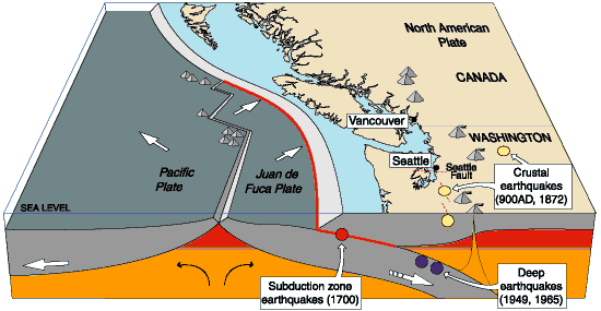
Another area most at risk, according to the report, is southern part of the BC North Coast zone, near Bella Bella, which is close to the northern section Cascadia Subduction Zone a “1,000 kilometre long dipping fault that stretches from Northern Vancouver Island to Cape Mendocino California” which one day will cause a major earthquake along the fault.
Cascadia subduction zone (USGS)
The report says that a magnitude 9.0 or higher earthquake in the northern Cascadia Subduction zone close to Bella Bella would be similar to the March 2011 earthquake in Japan and the 1964 Good Friday earthquake in Alaska.
For the northern part of the BC North Coast region, hazards could come from either a major earthquake off Haida Gwaii or a similar earthquake in south-eastern Alaska.
The greatest hazard would come from “long period” earthquakes greater than magnitude 6.75 with an epicentre between 300 and 350 kilometers away where the shaking lasts longer than one second.
The Geological Survey modeled three possible scenarios for major earthquakes in the BC North Coast Region.
Model #1. A magnitude 8.0 Earthquake at Haida Gwaii
The Geological Survey Canada model for an 8.0 magnitude earthquake west of Haida Gwaii. The possible damage is colour coded in the table below the map according to the Modified Mercalli Intensity Scale. The red polygon represents the area of possible rupture in the model with the star representing the epicentre. (Geological Survey of Canada)
The model looked at a “plausible maximum predicted” magnitude 8.0 thrust fault earthquake off the west coast of Haida Gwaii which would be twice as strong in the fault area as the 7.8 quake on October 28, 2012 (Remember Magnitudes are based on a logarithmic scale. That means for each whole number higher, the amplitude of the ground motion recorded by a seismograph goes up ten times so magnitude 8 earthquake would result in ten times the ground shaking as a magnitude 7 earthquake)
For a short period earthquake, the report estimates that there would be minimal damage on Haida Gwaii similar to the damage from the 2012 earthquake with little or no damage on the BC North Coast.
A long duration, long period earthquake that lasted longer than one second and up to three seconds or longer “may effect taller structures and trigger ground failure (that is liquefaction and lateral shaking).” Kitimat would feel that earthquake with the worst shaking in parts of the District with what the report calls “sensitive soils.” Coastal islands would feel double the amount of shaking as would occur in Kitimat.
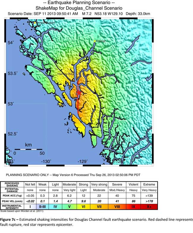
Model #2. A magnitude 7.2 Earthquake in Douglas Channel
The Geological Survey Canada model for a 7/2 magnitude earthquake in the lower Douglas Channel. The possible damage is colour coded in the table below the map according to the Modified Mercalli Intensity Scale. The red star represents the possible epicentre. (Geological Survey of Canada)
The second model looked at an earthquake in Douglas Channel based on the “fault like structure” if a slip strike rupture occurred along the entire 60 kilometers of the so far unconfirmed fault, resulting in a 7.2 magnitude earthquake. There would be very strong shaking within 20 kilometers radius of the epicentre, with moderate to heavy damage” in the relatively uninhabited islands, major shaking in Hartley Bay, resulting in very strong to strong damage at Hartley Bay and strong to moderate damage in Kitimat.
That earthquake, however, would be felt across the entire province of British Columbia. The report notes:
The expected effects and impacts of such an earthquake would mimic those of the 1946 magnitude 7.3 Vancouver Island earthquake, which occurred slightly west of Courtney and Campbell River. Shaking due to the 1946 earthquake was felt as far as Prince Rupert, BC to the north and Portland, Oregon to the south. In addition to knocking down 75 per cent of the chimneys in the local area, much of the earthquake-related damage was due to landslides, slumping and liquefaction
Model #3 A magnitude 6.3 Earthquake near Terrace
The Geological Survey Canada model for an 6.3 magnitude earthquake southwest of Terrace. The possible damage is colour coded in the table below the map according to the Modified Mercalli Intensity Scale. The red polygon represents the area of possible rupture in the model with the star representing the epicentre. (Geological Survey of Canada)
On May 11, 1973, a magnitude 4.7 shallow earthquake took place about 20 kilometers south west of Terrace, on the south side of the Skeena roughly across from the Shames mountain area. The earthquake was felt up to 120 kilometers away. The report says “The event has not been associated with any geologic features in the area and little is known about its rupture process.” The model estimated the results of a larger earthquake 6.3 magnitude in the same area. The model showed there would be strong to very strong shaking in Terrace, light to moderate shaking in Kitimat and light damage elsewhere in the BC North Coast. Most of the damage would be concentrated in a 20 kilometer zone around the epicentre.
The cause of the two failures is still unknown but the report says “their proximity to a nearby unmapped fault-like structure suggests that the slides could have been triggered by strong ground shaking from rupture along this structure.”
Another factor was the two well-known landslides occurred in the 1970’s in the Kitimat Arm which generated tsunamis but fortunately they occurred at low tide which decreased the impact. On October 17, 1974 a submarine slide generated a 2.8 metre tsunami. The following year on April 27, 1975, a slope failure on the northeast side of Kitimat Arm (which overlapped the 1974 failure area) displaced an estimated upper limit of 26,000,000 cubic metres of material.
“Watermark observations in Kitamaat Village estimated that the tsunami generated by this slide was up to 8.2 metres high.” The report says that while the trigger of the first event is unknown; the latter event coincided with nearby construction at that time. Modelling of the 1975 slide estimates that given the right conditions the generated tsunami waves could have been as high as 11 metres.
The report also notes that numerous landslides have also been mapped by the BC Department of Forestry in an attempt to improve safety measures for forestry workers.
The report says “The culmination of these studies brings awareness to the significant natural hazards present in the fragile coastal environment of the Coast Ranges.”
Another factor is the geology of the BC coast. The granitic mountains have rugged, steep slopes dissected by an intricate fjord system and dotted with islands of lower elevation. At lower elevations the land is covered by wet, coastal hemlock forests, which could be vulnerable to ground failures whereas higher elevations are characterized by barren rock or mountain hemlock subalpine.
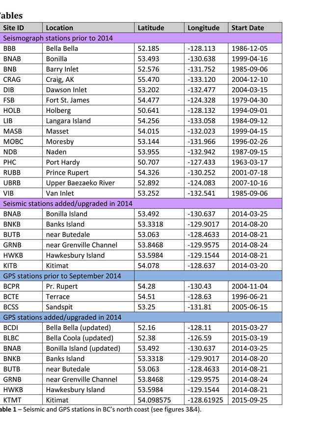
Table of Seismic monitoring and GPS stations in northern BC from the Geological Survey of Canada (Geological Survey of Canada)
The District of Kitimat said it has “not directly studied these issues but we are aware of potential hazards.” The development department has been advised of potential issues and site concerns.
A spokesperson for Terrace mayor Carol Leclerc told Northwest Coast Energy News in an e-mail. “I have reviewed it and distributed it to the relevant department heads. We are aware that historically Terrace has been at risk for experiencing seismic activity due to its location.”
The District of Kitimat did cooperate with National Resources in finding a location for their recently installed seismic equipment.
At Harley Bay, Gitga’at First Nation CEO Ellen Torng said the Gitga’at have been “ working with NRCan on their research in the Douglas Channel and in Hawksbury. NRC has been meeting with First Nations along the coast and have conducted community sessions on their research.
“We hosted one community session here in Hartley Bay and have regular updates from their technical team when they are in the area,” Torng said.
In addition, the District of Kitimat told Northwest Coast Energy News that Community Planning & Development department also provided local land information to geoscientists in the years leading up an international study called Batholiths on land in 2009.
Batholiths are large zones of molten rock that have solidified in the earth’s crust and are believed to play a key role in the formation and growth of continents. The Coast Mountain Range has a large concentration of batholiths, which means Kitimat was an excellent place to study the earth’s crust.
The project, which involved more than 50 scientists from nine Canadian and American universities, was set up to examine how mountain belts form and change over time and why continental mountain ranges are made of granite not basalt. Seismic imaging of the crust and mantle below the mountains required deploying thousands of seismic sensors and recorders, and recorded responses to several man-made detonations. Field work was completed in July 2009, and several scientific papers and dissertations have followed.
The Heiltsuk Nation was unable to respond to a request for comment due to the ongoing crisis from the sinking of the tug Nathan E. Stewart and the resulting spill of diesel fuel and other contaminants near Bella Bella.
Not felt except by a very few under especially favorable conditions.
II
Weak
Felt only by a few persons at rest,especially on upper floors of buildings.
III
Weak
Felt quite noticeably by persons indoors, especially on upper floors of buildings. Many people do not recognize it as an earthquake. Standing motor cars may rock slightly. Vibrations similar to the passing of a truck. Duration estimated.
IV
Light
Felt indoors by many, outdoors by few during the day. At night, some awakened. Dishes, windows, doors disturbed; walls make cracking sound. Sensation like heavy truck striking building. Standing motor cars rocked noticeably.
V
Moderate
Felt by nearly everyone; many awakened. Some dishes, windows broken. Unstable objects overturned. Pendulum clocks may stop.
VI
Strong
Felt by all, many frightened. Some heavy furniture moved; a few instances of fallen plaster. Damage slight.
VII
Very strong
Damage negligible in buildings of good design and construction; slight to moderate in well-built ordinary structures; considerable damage in poorly built or badly designed structures; some chimneys broken.
VIII
Severe
Damage slight in specially designed structures; considerable damage in ordinary substantial buildings with partial collapse. Damage great in poorly built structures. Fall of chimneys, factory stacks, columns, monuments, walls. Heavy furniture overturned.
IX
Violent
Damage considerable in specially designed structures; well-designed frame structures thrown out of plumb. Damage great in substantial buildings, with partial collapse. Buildings shifted off foundations.
X
Extreme
Some well-built wooden structures destroyed; most masonry and frame structures destroyed with foundations. Rails bent.
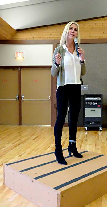
LNG Canada says the Kitimat liquified natural gas project “has been delayed and not cancelled” with a Final Investment Decision possible in the next 18 to 24 months, Director of External Relations Susannah Pierce told a company sponsored community pizza party at Riverlodge on Tuesday October 18, 2016.
She paid tribute to the support for the project from Kitimat and the Haisla Nation, saying, “Thanks to you we were very close to have our shareholders take the Final Investment Decision in the New Year,” but she then added, “You also know there were some things we couldn’t control like the state of the marketplace.”
LNG Canada Director of External Relations Susannah Pierce updates Kitimat residents on the project at Riverlodge, Tuesday Oct. 18. 2016 (Robin Rowland/Northwest Coast Energy News)
Pierce used the analogy of someone saving up to buy a car and believing that they have enough money in the bank and then the conditions change. “That is what happened to us,” she said. “You still want the car, but you just have to wait a little longer.”
Pierce said that the current program of site preparation will pause for the winter and holidays in mid-December. After that “work will begin to wind down over the next few months and then we will preserve the site until we are ready to make the Final Investment Decision.” She said LNG Canada is studying ways to make site preservation cost effective.
“We are doing everything we can to keep our pencils sharp and keep the community informed so that when the project is approved we are ready,” she added.
She pointed out that LNG Canada has already built a fisheries habitat offset in preparation for full development of the site.
LNG Canada and its partner shareholders are keeping a close eye on the developments of the natural gas market in Asia and Pierce said, “We do expect to be sending LNG to the Asian market in the next decade, so 2023 and beyond is what we’re talking about.”
She said that the Final Investment Decision when it comes will bring opportunities for Kitimat, the province and the whole country.
“Everyone in this room and everyone at LNG Canada is working to make this project real,” Pierce said.
“For those who are staying with us, we’re here, we’re not going anywhere and we’re going to be available to the community for an number of events. Let’s make it happen. We do have a shot at making it real but it may not happen as soon as you’d like it.”
Northern Gateway pipelines says the company will not appeal the Federal Court of Appeal decision that blocked the approval certificate by the Joint Review Panel and the National Energy Board because there had been insufficient consultation with First Nations.
OTTAWA — The federal government is joining Enbridge Inc. in not appealing a Federal Court of Appeal ruling quashing a 2014 Conservative decision to approve the $7.9 billion Northern Gateway pipeline, Postmedia has learned.
John Carruthers, President of Northern Gateway said in a news release, “We believe that meaningful consultation and collaboration, and not litigation, is the best path forward for everyone involved. We look forward to working with the government and Aboriginal communities in the renewed consultation process.”
Northern Gateway news release
VANCOUVER, Sept. 20, 2016 /CNW/ – Northern Gateway will not appeal a recent Federal Court of Appeal decision that reversed the project’s federal approval certificate. The Federal Court of Appeal found that the National Energy Board’s Joint Review Panel recommendation was acceptable and defensible on the facts and the law. The Court, however, concluded that further Crown consultation is required.
Northern Gateway supports the path outlined by the Federal Court of Appeal for the Federal Government to re-engage with directly affected First Nations and Métis communities to ensure thorough consultation on Northern Gateway is undertaken.
Statement from John Carruthers, President, Northern Gateway:
Northern Gateway’s Ray Philpenko gives a presentation on pipeline leak detection to Kitimat Council, Feb. 17. 2014. (Robin Rowland/Northwest Coast Energy News)
“We believe that meaningful consultation and collaboration, and not litigation, is the best path forward for everyone involved. We look forward to working with the government and Aboriginal communities in the renewed consultation process. We believe the government has a responsibility to meet their Constitutional legal obligations to meaningfully consult with First Nation and Métis. It also reflects the first priority of Northern Gateway and the 31 Aboriginal Equity Partners to build meaningful relationships with First Nation and Métis communities and ensure their voice is reflected in the design of the project.
We believe that projects like ours should be built with First Nation and Métis environmental stewardship, ownership, support, and shared control. Northern Gateway, the Aboriginal Equity Partners, and our commercial project proponents remain fully committed to building this critical Canadian infrastructure project while at the same time protecting the environment and the traditional way of life of First Nation and Métis and communities along the project route.
In order to encourage investment and economic development, Canadians need certainty that the government will fully and properly consult with our nation’s Indigenous communities. We look forward to this process and assisting those communities and the Federal Government with this important undertaking in any way we can.
The economic benefits from Northern Gateway to First Nation and Métis communities are unprecedented in Canadian history. As part of the opportunity to share up to 33 percent ownership and control in a major Canadian energy infrastructure project, the project’s Aboriginal Equity Partners will also receive $2 billion in long-term economic, business, and education opportunities for their communities.
The project would add over $300 billion to Canada’s gross domestic product over the next 30 years, 4,000 construction jobs and 1,000 long-term jobs, $98 billion in tax revenue, and an estimated $100 million investment in community programs and services. Northern Gateway will provide a badly needed multibillion dollar private infrastructure investment in Canada’s future.”
Statement from the Aboriginal Equity Partner Stewards (Bruce Dumont, President, Métis Nation British Columbia; David MacPhee, President, Aseniwuche Winewak Nation; Chief Elmer Derrick, Gitxsan Nation Hereditary Chief; Elmer Ghostkeeper, Buffalo Lake Métis Settlement):
“We support Northern Gateway’s decision to not appeal the recent decision by the Federal Court of Appeal. This is a reflection of the commitment to the new partnership we are building together and their support of meeting Constitutional obligations on government to consult.
The Federal government has publically stated they are committed to reconciliation with First Nation and Métis communities. As such, we are now calling on this same government to actively and fully undertake the required consultation as directed by the Federal Court of Appeal in relation to the Northern Gateway project.
The Aboriginal Equity Partners is a unique and historic partnership that establishes a new model for conducting natural resource development on our lands and traditional territories. We are owners of Northern Gateway and are participating in the project as equals.
Environmental protection remains paramount and as stewards of the land and water, and as partners in this project, First Nation and Métis communities have a direct role in the environmental protection of the lands, waters, and food sources along the pipeline corridor and in marine operations. Our traditional knowledge, science, and values will be used to design and operate land and coastal emergency response to make the project better. We believe with this project there is an opportunity to work together with the Federal Government to improve marine safety for all who live, work, and depend on Canada’s western coastal waters.
This ownership ensures environmental stewardship, shared control, and negotiated business and employment benefits. Collectively, our communities stand to benefit from more than $2 billion directly from this Project.
Our communities need the economic and business benefits that Northern Gateway can bring. We are focused on ensuring our communities benefit from this project and are actively involved in its decision making so we can protect both the environment and our traditional way of life through direct environmental stewardship and monitoring.
Our goal is for Northern Gateway to help our young people to have a future where they can stay in their communities with training and work opportunities. We remain committed to Northern Gateway and the opportunities and responsibilities that come with our ownership. We also remain committed to working with our partners to ensure our environment is protected for future generations.”
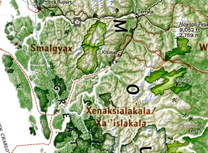
The September issue of National Geographic includes a large map of British Columbia it calls “Claiming British Columbia.”
(National Geographic)
The map has three themes: First Nations’ traditional territory, the routes of proposed pipeline projects, both LNG and diluted bitumen, and it features a sub map that looks at what the map calls the “Troubled Salmon” fishery.
The cartographers at National Geographic are being very careful, avoiding such troubling issues as competing land claims among First Nations, unresolved land claims with the federal and provincial governments and treaty status.
(National Geographic)(National Geographic)
So by and large the map groups First Nations by language group unless there are definite treaty or reserve boundaries. Large reserves under the Indian Act are on the map, but given the post stamp size of many reserves in British Columbia, those reserves are too small to be seen on the map. Towns and cities are identified as “First Nations” communities which often overlap with settler communities. Again the map misses many smaller communities, so Kitimat is on the map, while Kitamaat Village is not.
(National Geographic)
The map identifies Haisla traditional territory as “Xenaksilakala/Xa”islakala” and also includes the Kitlope Heritage Conservancy Protected area.
The article in the September issue is called The Pacific Coast, but unfortunately there is not much of a tie-in with the map, since it concentrates on California and Alaska with only a passing mention of British Columbia.
On the obverse side of the map is the poster that is promoted on the magazine cover, a beautiful painting of “The Changing Pacific Coast” which covers kelp and every creature from phytoplankton and zooplankton all the way to humpback whales and sea gulls (but for some reason no bald eagles). It is likely that poster will be on display in classrooms up and down the coast before school opens next week.
The Ice Age First Nations in the interior of Alaska relied more heavily on salmon and freshwater fish in their diets than previously thought, according to a new study from the University of Alaska Fairbanks.
First Nations of the Pacific Coast have always recognized the value of the salmon. Archaeologists have used new techniques to date the remains of salmon found in hearths back more than 11,000 years. The results now offer a more complex picture of Alaska’s ice age residents, who were previously thought to have a diet dominated by terrestrial mammals such as mammoths, bison and elk.
A team of researchers made the discovery after taking samples from 17 prehistoric hearths along the Tanana River, then analyzed stable isotopes and lipid residues to identify fish remains at multiple locations.
The project also found the earliest evidence of human use of anadromous salmon in the Americas, dating back at least 11,800 years.
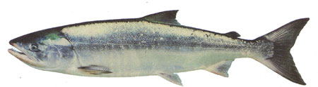
Chum salmon (DFO)
The results of the study were published today in the Proceedings of the National Academy of Sciences.
DNA analysis of chum salmon bones from the same site on the Tanana River had previously confirmed that fish were part of the local indigenous diet as far back as 11,500 years ago. But fragile fish bones rarely survive for scientists to analyze, so the team used sophisticated geochemistry analyses to estimate the amount of salmon, freshwater and terrestrial resources ancient people ate.
A team led by UAF postdoctoral researcher Kyungcheol Choy analyzed stable isotopes and lipid residues, searching for signatures specific to anadromous fish. The effort demonstrated that dietary practices of hunter-gatherers could be recorded at sites where animal remains hadn’t been preserved.
“It’s quite new in the archaeology field,” Choy said. “There’s a lot in these mixtures that’s hard to detect in other ways.”
Ben Potter, a professor of anthropology at UAF and co-author of the study, said the findings suggest a more systematic use of salmon than DNA testing alone could confirm.
“This is a different kind of strategy,” Potter said. “It fleshes out our understanding of these people in a way that we didn’t have before.”
The study required cooperation between UAF’s Department of Anthropology and the Institute of Northern Engineering’s Alaska Stable Isotope Facility to locate and interpret the presence of salmon remains at the sites. Potter said the process could be a template for how a diverse team of researchers can work together to overcome a scientific obstacle.
“It’s an awesome look at how we can merge disciplines to answer a question,” he said.
Monday’s decision by LNG Canada to postpone the all-important Final Investment Decision for the Kitimat liguified natural gas project came as a momentary shock—but no real surprise. After the Brexit vote, you could see the hold button blinking from across the Atlantic.
Andy Calitz CEO of LNG Canada and a long time, experienced, executive with the lead partner, Royal Dutch Shell blamed the current market conditions for natural gas in both a news release and an investors’ conference call. However, the turmoil in the world economy brought about by Britain’s (largely unexpected) vote to leave the European Union made the postponement inevitable.
Immediately after the vote on June 23, when the now not so United Kingdom voted by 52 per cent to 48 per cent, to leave the European Union, financial analysts predicted that given the uncertainty, companies based in the United Kingdom would immediately begin to adjust their long term planning.
The stock market has stabilized and reached new highs, at least for now, but the British pound remains weak.
Most important, according to reports in the business press around the world, many long term projects by companies not only in the UK but everywhere are being re-examined, postponed or cancelled. All due to the long term uncertainty in world markets.
Even without Brexit, the situation with long term planning for the natural gas market is complicated, as LNG Canada’s External Affairs Director Susannah Pierce explained in this interview on CKNW ‘s Jon McComb show. ( It is an informative interview. Autoplays on opening the page)
“ Postpone investment decisions”
Royal Dutch Shell is one of the world’s largest corporations. It is based in the United Kingdom although its corporate headquarters are in the Netherlands (also a member of the European Union).
From June 24 to July 11 was just enough time for the bean counters and forecasters in London, Vancouver, Calgary, Tokyo and Beijing to crunch the numbers and decide that the prudent move would be to put the LNG Canada project on hold.
Rio Tinto is also a dual national company, listed on both the London and Australian stock exchanges and with its headquarters in London. (More about Rio Tinto later.)
Although both Shell and Rio Tinto are giant transnationals with operations worldwide, the turmoil in the United Kingdom, in the corridors and cubicles of the home offices, is having a psychological and personal, as well as professional, impact, meaning more of the work in those towers of London will be focused on Brexit.
The decision doesn’t mean that the LNG Canada Final Investment Decision will be on hold forever. Of all the world’s energy companies, Shell is one of the oldest and it has a solid reputation for better long term planning than some of its competitors.
In the news release, Calitz noted
I can’t say enough about how valuable this support has been and how important it will be as we look at a range of options to move the project forward towards a positive FID by the Joint Venture participants.
The news release goes on to say
However, in the context of global industry challenges, including capital constraints, the LNG Canada Joint Venture participants have determined they need more time prior to taking a final investment decision. decision.
How much time? Well, as Theresa May became the Prime Minister of Great Britain, the New York Times noted, like other media, that investment decisions are on hold:
Ms. May does not plan to depart the union quickly because it could put Britain’s negotiators under pressure, and at a disadvantage…
And the longer Britain drifts, the greater the uncertainty for businesses that could postpone investment decisions until things are clearer, potentially pushing the nation into a recession.
The extrication of Britain from Europe will likely be more in the character of the Greek financial collapse, a seemingly endless process where each event and each piece of news has the power to set off a new round of financial fears.
And like the Greek crisis, each piece of bad news will compound fears in markets that were nervous for other reasons.
So once (and when) Theresa May invokes Article 50 that opens a two year window for Britain to leave the European Union, starting negotiations for Brexit. Then it gets complicated, if Scotland votes to leave the United Kingdom or if Northern Ireland also demands a dual referendum in both the Republic and the North on a united Ireland (as permitted under the Good Friday Peace Agreement).
Although May says she will continue to the UK`s next fixed date election, what if May calls a snap general election, with an uncertain outcome, perhaps another minority government, with seats split among several parties, including those who advocate remaining in the EU?
The price of oil is still low compared to a few years ago. That price is expected to remain low with all that the Saudis are pumping to retain market share, the Iranians want to recover from sanctions, and according to Pittis in another column, that means everyone else is pumping as well
The main thrust for Canadian producers is to build more pipelines so they can expand capacity and push ever more of their relatively expensive oil into the world supply chain. If that’s the strategy for high-cost producers, how could anyone think the world’s lower-cost producers wouldn’t be doing the same thing?
There is the glut of natural gas currently in Asian markets and no one knows what Brexit will mean. Unless there’s a drastic change in the marketplace, energy project investment will remain on hold for years to come. (So forget any dreams of a refinery anywhere on the coast. )
Rio Tinto
Brexit is also going to be a problem for London based Rio Tinto—and for the current negotiations with the Unifor local in Kitimat. Rio Tinto’s bottom line is weak because the price of iron ore, its main source of income, has been dropping. After completing the $4.8 billion Kitimat Modernization Project, Rio Tinto is spending huge amounts of money on its Oyu Tolgoi copper and gold and other minerals mine in Mongolia, a project that many analysts believe could provide up to 60 per cent of Rio Tinto profits as commodity markets recover.
Add to that US presidential election. Donald Trump has threatened to halt imports of both steel and aluminum into the United States if he actually gets to sit in the White House.
On June 29, outgoing President Barack Obama also looked at aluminum at the recent “Three Amigos” summit in Ottawa, noting in the news conference.
Given the flood of steel and aluminum on the global markets, however, it points to the fact that free trade also has to be fair trade.
That means if Hilary Clinton becomes president, she will also be looking at the state of aluminum imports to the United States market.
World conditions are a warning for the Unifor negotiating team in Kitimat. One reason for last year’s prolonged municipal strike was that Unifor spent a good deal of time planning for negotiations with the District but failed to adjust its contract demands when the price of oil unexpectedly collapsed, which meant the District had less money and a lot less flexibility.
In its negotiations with Rio Tinto, Unifor cannot make the same mistake again. There were a handful of unexpected layoffs down at Smeltersite on June 30; there could be more layoffs in the future. Mandatory overtime is a major sticking point—but that overtime demand is coming from the bean counters in Montreal and London, calculating that the overtime costs are, in the long term, less expensive than a lot of new hires.
Media reports show that Rio Tinto is in tough negotiations with its employees around the world. With LNG on hold, disgruntled employees can’t just turn off Haisla Boulevard to the old Methanex site before reaching Rio Tinto’s property line. That means Unifor should be tough but very realistic in its talks with Rio Tinto, knowing that the powers that be that hold the strings in London are more worried about what Brexit will do to the company bottom line than any temporary shutdown of the smelter by a strike.
What does this mean for Kitimat?
A We Want LNG Canada lawn sign in Kitimat. (Robin Rowland/Northwest Coast Energy News)
So the boom and bust cycle once again moves to bust.
Ellis Ross, chief councillor of the Haisla First Nation, speaking to CBC Radio said Ross said
the Haisla nation has been working to get its people jobs in the construction of the facility and related infrastructure, as well as full-time jobs once the plant opens…This was our first chance as Haisla to be a part of the economy, to be part of the wealth distribution in our area. To witness the wealth generation in our territory for the last six years but to not be a part of it, and now to continue to not be a part of it, is really distressing to us, because we had built up our entire future around this.
Mayor Phil Germuth in the same interview said
There’s no doubt that there’s going to be a little bit of hurt for a while, but we still fully believe that Kitimat is by far the absolute best location anywhere on the West Coast [for] a major LNG export facility… We are absolutely confident that it will come.
There’s time in this bust for everyone in town to recover from the hangover of the past few years of the fight over Northern Gateway and the heady hopes of the LNG rush. Demand for natural gas is not going to go away, especially as climate change raises the pressure to eliminate coal, so it is likely that LNG Canada will be revived.
It’s time to seriously consider how to diversify the Valley’s economy, making it less dependent on the commodity cycle. It’s time to stop chasing industrial pipe dreams that promise a few jobs that never appear.
Like it or not, the valley is tied to globalization and decisions made half way around the world impact the Kitimat Valley.
Who knows what will happen in 2020 or 2025 when the next equivalent of a Brexit shocks the world economy?
Suppose, as some here would wish, that all the opposition to tankers and pipelines suddenly disappeared overnight. Does that mean that the projects would then go ahead?
The corporate planners would decide based on their projections for the world economy and the viability of the project for their profit picture. Enbridge was never really able to secure customers for its bitumen. Chevron had no customers for Kitimat LNG. LNG Canada is a partnership, and the partner customers in Asia decided that at this time, the investment is too risky, even if LNG Canada’s longer term prospects are good.
Promoting tourism should now be the priority for Council, for Economic Development, for the Haisla Nation Council, for the local business.
Beyond tourism, it’s time for some innovative thinking to come up with other ideas that would free Kitimat from the commodity cycle. At the moment there are no ideas on the horizon, but unless everyone starts looking for new ideas, practical ideas, the commodity cycle will rule.
LNG Canada has postponed the Final Investment Decision on the Kitimat project citing the “impact of global industry challenges.” The latest estimates said that the project would cost $40 billion.
The news release says that despite strong community support and regulatory approval, what LNG Canada called “the context of global industry challenges, including capital constraints” led to the decision. In other words, the continued low price of oil is constraining projects across the energy industry.
LNG Canada’s Joint Venture Participants Delay Timing of Final Investment Decision
Impact of global industry challenges, despite strong project fundamentals
Vancouver, British Columbia — Today, LNG Canada announces that its joint venture participants – Shell, PetroChina, Mitsubishi Corporation and Kogas – have decided to delay a final investment decision on LNG Canada that was planned for end 2016.
LNG Canada remains a promising opportunity – it has strong stakeholder and First Nations’ support, has achieved critical regulatory approvals, has important commercial and engineering contracts in place to design and build the project, and through its pipeline partner Coastal Gas Link, has received necessary environmental approvals and First Nations support along the pipeline right-of-way.
“Our project has benefitted from the overwhelming support of the BC Government, First Nations – in particular the Haisla, and the Kitimat community. We could not have advanced the project thus far without it. I can’t say enough about how valuable this support has been and how important it will be as we look at
a range of options to move the project forward towards a positive FID by the Joint Venture participants,” said Andy Calitz, CEO LNG Canada.
Through their efforts to build a strong LNG sector for Canada, and a critical, cleaner energy alternative for the world, the governments of British Columbia and Canada have developed sound fiscal and regulatory frameworks for success.
However, in the context of global industry challenges, including capital constraints, the LNG Canada Joint Venture participants have determined they need more time prior to taking a final investment decision. At this time, we cannot confirm when this decision will be made.
In the coming weeks, LNG Canada will continue key site preparation activities and work with its joint venture participants, partners, stakeholders and First Nations to define a revised path forward to FID.
LNG Canada Joint Venture Participants are Shell (50%), PetroChina (20%), Mitsubishi Corporation (15%)
and Kogas (15%).
Haisla Nation chief councillor Ellis Ross issued a statement that said:
Haisla Nation Council very firmly believes in the future of liquefied natural gas for the Kitimat Valley and Haisla territory. It is an industry which has the capacity to grow jobs, provide new training opportunities and provide a sustained quality of life for Haisla members. It’s worth remembering that LNG Canada is a relatively new project to the area, and decisions on major projects such as these can take a long time to reach.
Today’s decision was the second time the FID was postponed. Andy Caloz LNG Canada’s CEO was quoted by Bloomberg News as saying that the project hasn’t been canceled. It has all the necessary approvals from regulators in Canada and doesn’t require any more work in the country.
“The whole global LNG industry is in turmoil,” Calitz told a conference call, Bloomberg reported, adding that Western Canada still has advantages including its proximity to customers in Asia. “I’m confident that the Japanese market remains available to LNG Canada.”
The National Energy Board has indefinitely suspended its consideration of the $7.9 billion Northern Gateway pipeline project, including the request by Enbridge to extend the deadline for starting the controversial project. The Joint Review Panel conditions had set December 31, 2016 as the time that Enbridge had to start the project.
As a result of the decisions quashing the Certificates, the Board is suspending indefinitely its consideration of the application to extend the sunset clauses of the Certificates and is not accepting any further comments on it, including comments from Northern Gateway and AEP. The Board is also suspending indefinitely its consideration of all filings related to the conditions attached to the Certificates.
In May the NEB had told Enbridge that is would consider a request by Enbridge to extend the deadline and accept comments from the public until June 27, 2016 and reply comments from the applicants by July 18, 2016.
Cover of Volume 2 of the Joint Review ruling on Northern Gateway
In a decision released on 30 June 2016, the Federal Court of Appeal quashed Order in Council P.C. 2014-809 which is the order directing the Board to issue the Certificates for the Project. The Court also quashed the Certificates.
The original Joint Review Panel report in December 2013 had set 209 conditions for the construction and operation of the pipeline, which would have carried oil sands bitumen from Bruderheim, Alberta, to Kitimat, for shipment to Asian customers.
In a two to one decision, the Federal Court of Appeal has overturned the Harper government’s approval of the Enbridge Northern Gateway Pipeline, finding that the federal government’s consultation process with First Nations on the BC coast that occurred after the NEB decision and the Joint Review Panel Report was inadequate, saying:
We conclude that Canada offered only a brief, hurried and inadequate opportunity in Phase IV—a critical part of Canada’s consultation framework—to exchange and discuss information and to dialogue. The inadequacies—more than just a handful and more than mere imperfections—left entire subjects of central interest to the affected First Nations, sometimes subjects affecting their subsistence and well-being, entirely ignored.
The dissenting judge found that the federal government under Stephen Harper had adequately consulted the First Nations. The split decision means that one of the parties, either the federal government, Enbridge Northern Gateway or the Canadian Association of Petroleum Producers may seek leave to appeal to the Supreme Court of Canada.