Analysis:   New scientific findings likely confirm Haisla story of first arrival in the valley

Two related scientific papers published in the past two weeks, one on the First Peoples  initial settlement of coastal  North America and the second  giving a probable new timeline of the retreat of the glaciers during the last Ice Age,  taken together  are likely confirmation of the Haisla story of how that nation first settled the Kitimat Valley.

Haisla NationAs related in Gordon Robinson’s Tales of the Kitamaat, the First Peoples living on the coast of what is now British Columbia ventured up what is now called Douglas Channel perhaps from either Bella Bella in Heiltsuk traditional territory or from Prince Rupert in Tsimshian traditional territory.

The young men on the expedition up the Kitimat Arm spotted what they thought was a huge monster kilometres ahead with a large mouth that was constantly opening and closing. The sight was so terrifying that the men fled back to their homes and dubbed the Kitimat Arm as a place of a monster.

Later a man named Hunclee-qualas accidentally killed his wife and had to flee from the vengeance of his father-in-law.   Knowing he had to find a place where no one could find him,  he ventured further up the Kitimat Arm. There he discovered that the “monster” was nothing more than seabirds, probably seagulls, perhaps feasting on a spring oolichan run.

He settled along the shore of what is now the Kitimat River and found a land of plenty, with fish, seals, game as well as berries and other natural products of the land.  Eventually he invited others to join him, which began the Haisla Nation and he became their first chief.

Let’s examine the new evidence so far.

  1. Settlement along the coastal “kelp highway” between 18,000 and 16,000 years ago, followed by a warm spell 14,500 years ago

It’s now fairly certain that the First Peoples first began to settle along the coast by following the “kelp highway” perhaps as early as 18,000 years ago and certainly by 14,000 years ago.  Haida Gwaii was ice free, except for some mountain glaciation as early as 16,500 years ago.   At about 14,500 years ago there was a warming spell which forced the glaciers to retreat, brought higher sea levels and the arctic like tundra ecosystem would have been replaced, at least for a time, by forests. There is the discovery of a Heiltsuk settlement dated to 14,000 years ago.  At that time almost all of the coast would have been free of glacial ice but there were still glaciers in the fjords, including the Kitimat Arm which would mean there could be no permanent settlement in the “inland coast” and the interior.

(Science)
  1. The cooling period from 14,000 to 11,700 years ago confines settlement to the coast

The cooling periods  (with occasional warmer times) from about 14,000 years ago to about 11,700 years ago meant that settlement would largely have been confined to the coast for about two and half millennia. The culture of the coastal First Peoples would have been well established by the time the glaciers began the final retreat.

(Remember that it is just 2,000 years from our time in 2017 back to the height of the Roman Empire under Augustus Caesar).

It is likely that the cooling periods also meant that some descendants of initial settlers likely headed south for relatively warmer climates. Rising sea levels meant that the initial settlement villages would likely have been abandoned for higher ground.

  1. A second period of rapid warming 11,700 years ago which opens up the interior fjords and valleys

At the end of what geologists call the Younger Dryas period, about 11,500 years ago, the climate warmed, the glaciers retreated further, in the case of Kitimat, first to what is now called Haisla Hill, then to Onion Flats and finally to Terrace.

  1. Large glacial sediment river deltas filled with fresh melt water from retreating ice

The most important confirmation of the story of Hunclee-qualas’s exile is the account  of the monster, the birds and the oolichan run.

The new scientific evidence, combined with earlier studies, points to the fact that the glacial melt water carried with it huge amounts of glacial sediment that created vast river deltas in coastal regions of the Northern Hemisphere.

That means around 10,000 years ago,   when the Kitimat Valley was ice free and the new forest ecosystem was spreading up the valley, the Kitimat River estuary was likely to have been much larger than today.  It could have been a vast delta, which would have quickly been repopulated with fish, including salmon and oolichan. That rich delta ecosystem could have supported a much larger population of seabirds than the smaller estuary in recent recorded history.

Snow geese by the thousands in the Sacramento-San Joaquin Bay Delta/ CrunchySkies/Wikimedia Commons/Creative Commons License

The story of the monster those first travelers saw far off is highly plausible. Even today in huge, rich deltas elsewhere in the world, seeing hundreds of thousands of birds in flight over a wetland is fairly common. (For a description of what a Kitimat River delta may have been like thousands of years ago, see KCET’s story on the Sacramento-San Joaquin Bay Delta and what that delta was like 6,000 years ago)

The First Peoples had had well established communities for up to four thousand years before the Kitimat Valley’s metres of thick ice had melted away.  For the first period, while the ecosystem regenerated, for the people of the coast coming up Douglas Channel to the valley would not have been worth it, there would be little to find in terms of fish, game or forest resources.

A Snow Goose flock near the Skagit River Delta, WA./ Walter Siegmund/Wikimedia Commons
  1. The change from tundra to a rich forest environment

Eventually as the forest regenerated, the streams filled with salmon and oolichan; the bird population including gulls, geese and eagles, found a new feeding ground;  bears, deer and other animals arrived. The Kitimat region would have been an attractive place to explore and hunt. It may be the monster story did keep people away until Hunclee-qualas had to find a place to hide and discovered a new home just at a time that might be called an ecological optimum with new forests stretching back along the valley to what is now Terrace.

  1. The river delta shrinks back to the current estuary

If a vast Kitimat River delta did stretch further down the Channel than it does in 2017, it likely shrank back in the subsequent millennia.   Eventually the mass of glacial sediment that came downstream after the retreat of the ice would diminish, but not stop entirely. The estuary is still rebuilt from sediments washed downstream but that sediment doesn’t match other  rich deltas elsewhere such as the Nile in Egypt.   With that regeneration of the delta slower and smaller than in the first centuries of Haisla settlement, at the same time the land surface rebounded from the weight of the ice, perhaps creating the Kildala neighborhood.  The ocean level rose, drowning and eroding part of the old delta, creating the estuary we know today.


As the authors of the paper on the First Peoples’ settlement note, most of the archaeological evidence of early coastal settlement is now likely many metres below the surface of the ocean but deep ocean exploration may uncover  that evidence.  As the scientific team on the second paper say, they are now working on detailed studies of the glacial retreat from the coastal mountain region which may, when the studies are complete, change the timeline

While waiting for further evidence from archaeology and geology it is safe to say that the stories of the monster and later Hunclee-qualas’s discovery of the Haisla homeland are even more compelling than when Gordon Robinson wrote Tales of the Kitamaat.  We can now speculate that there was once, stretching from Haisla Hill far down the Channel, a vast, varied rich, river estuarine delta that supported hundreds of thousands of seabirds, which if they took the wing in unison, would have made those unwary travelers millennia ago, really think that there was a giant monster waiting to devour them at the head of the Kitimat Arm.


West Coast “kelp highway” was the earliest route for First Peoples’ settlement of the Americas is the new scientific consensus

Most historians and archaeologists believe that the First Peoples to arrive in North America came down the West Coast on what they now call the “kelp highway.”

The review paper “The First Americans” was published this week in the prestigious journal Science.

Evidence from archaeological sites from the British Columbia coast to the southern tip of South America show that First Peoples had settled on both continents by at least 18,000 years ago, according to authors T.J. Braje at San Diego State University in San Diego, CA; T.D. Dillehay at Vanderbilt University in Nashville, TN; J.M. Erlandson at University of Oregon in Eugene, OR; R.G. Klein at Stanford University in Stanford, CA; T.C. Rick at National Museum of Natural History, Smithsonian Institution in Washington, DC.

The paper also says the DNA genomic data suggests a northeast Asian origin for Native American ancestors some time in the past 20,000 years.

(Science)

One of the key sites cited in the paper is Triquet Island in the traditional territory of the Heiltsuk Nation which has been dated to at least 14,000 years ago. Heiltsuk oral history has marked the island for generations, William Housty a member of the Heiltsuk told CBC News at the time the discovery was officially announced in April 2017, “Heiltsuk oral history talks of a strip of land in that area where the excavation took place. It was a place that never froze during the ice age and it was place where our ancestors flocked to for survival.”

The authors of the review say the new consensus on the “kelp highway” is a “dramatic intellectual turnabout” from the original idea that the first indigenous settlers followed an ice free corridor from a land bridge from Siberia down the centre of North America to form the “Clovis Culture”

The land bridge between northeast Asia and North America, commonly called Beringia, came about when sea levels fell during the last ice age. Although the original Beringia hypothesis has been disputed by some First Peoples, the paper says the Beringia hypothesis is still a factor—but much farther back in time, now about 24,000 years ago.

The paper says:

most archaeologists and other scholars now believe that the earliest Americans followed Pacific Rim shorelines from northeast Asia to Beringia and the Americas.

According to the kelp highway hypothesis, deglaciation of the outer coast of North America’s Pacific Northwest about 17,000 years ago created a possible coastal corridor rich in aquatic and terrestrial resources along the Pacific Coast, with productive kelp forest and estuary  ecosystems at sea level and no major geographic barriers

The paper says that kelp resources extended as far south as Baja California, and then—after a gap in Central America, where productive mangrove and other aquatic habitats were available—picked up again in northern Peru, where the cold, nutrient-rich waters from the Humboldt Current supported kelp forests as far south as Tierra del Fuego.

The other sites cited in the paper are

  • Huca Prieta, Peru 15,000 to 14,500 years ago
  • Paisley Caves, Oregon 14,000 years ago
  • Monte Verde, Chile 14,500 years ago
  • Page-Ladson, Florida 14,500 years ago
  • Channel Islands California 13,000 years ago
  • Quebrada Santa Julia and Quebrada Huentelauquén , Chile 13,000 years ago
  • Quebrada Tacahuay Peru 13,000 years ago
  • Quebrada Jaquay, Peru 13,000 years ago

In an earlier article in Science in August, Knut Fladmark, a professor emeritus of archaeology at Simon Fraser University who was one of the first to propose a coastal migration into the Americas back in 1979, said: “The land-sea interface is one of the richest habitats anywhere in the world,” noting that early Americans knew how to take full advantage of its abundant resources.

Testing the kelp highway hypothesis is challenging, the scientists say, because much of the archaeological evidence would have been submerged by rising seas since the end of the last “glacial maximum,” about 26,500 years ago.

The earlier that the First Peoples arrived, that means the land they originally settled is now the further offshore from the current coast  (land which is now likely also at greater depth under the current ocean). So the review says that finding the evidence means that, “enlarging already vast potential search areas on the submerged continental shelf.”

The authors say:

Although direct evidence of a maritime pre-Clovis dispersal has yet to emerge, recent discoveries confirm that late Pleistocene archaeological sites can be found underwater. Recent discoveries at the Page-Ladson site, in Florida produced 14,500-year-old butchered mastodon bones and chipped stone tools in the bottom of Florida’s Aucilla River.

The report says that “Several multidisciplinary studies are currently mapping and exploring the submerged landscapes of North America’s Pacific and Gulf of Mexico coasts, searching for submerged sites. .

In British Columbia, those studies (pdf) include the discovery by Daryl Fedje, an archaeologist at the University of Victoria and the Hakai Institute of 29 footprints on Quadra Island. A piece of wood embedded in a footprint’s fill provided the radiocarbon date of 13,200 years ago and the spear points lying and a cluster of bear bones at Gaadu Din cave on the Haida Gwaii dated to 12,700 years ago.

The review says that for much of the 20th century, most archaeologists believed humans first colonized the Americas about 13,500 years ago via the overland route that crossed Beringia and followed a long and narrow, mostly ice-free corridor to the vast plains of central North America. There,  according to the earlier theories, Clovis people and their descendants hunted large game and spread rapidly through the New World.

This was initially confirmed by twentieth-century discoveries of distinctive Clovis artifacts throughout North America. Some finds associated with mammoth or mastodon kill sites, supported this “Clovis-first” model.

The early studies decided then that “North America’s coastlines and their rich marine, estuarine, riverine, and terrestrial ecosystems were peripheral to the story of how and when the Americas were first settled by humans.”

Now the recent work along the Pacific coastlines of North and South America has revealed that these environments were settled early and continuously, providing a rich diversity of subsistence options and technological resources for New World hunter-gatherers.

A detail of the map from Science shows how off from the current coast the ancient shorelines reached (Science)

At the moment,  there is little evidence on the coast so far of the kind of  stone tools and fishtail points that had previously provided a road map that archaeologists used to trace the spread of “Clovis” Paleoindians throughout the Americas. Such a roadmap is lacking for “pre-Clovis” sites on the coast.

One proposal is that distinctive stemmed (“tanged”) chipped-stone projectile points, crescents (lunate-shaped), and leaf-shaped bifaces found in Japan, northeast Asia, western North America, and South America could be potential markers of an earlier coastal migration and  ties to Ice Age peoples in East Asia.

The problem of finding final proof of the kelp highway is that the First Peoples followed a coastal route from Asia to the Americas, so that finding evidence for their earliest settlements will require careful consideration of the effects of sea level rise and coastal landscape evolution on local and regional archaeological records.

The scientists note that around the globe, evidence for coastal occupations between  about 50,000 and 15,000 years ago are rare because of postglacial sea level rise, marine erosion, and shorelines that have migrated tens or even hundreds of kilometers from their locations at the ice age glacial maximum.

They say overcoming these obstacles requires interdisciplinary research focused on coastal areas with relatively steep offshore bathymetry, formerly glaciated areas where ancient shorelines have not shifted so dramatically, or the submerged landscapes that are one of the last frontiers for archaeology in the Americas


Did Neanderthals honour the raven?

A new discovery by archaeologists in Crimea is providing evidence that ancient Neanderthals had a high cognitive and artistic ability. That evidence is the carved leg bone of a raven also raising the question (not actually included in the archaeologist’s paper) does the relationship between human and raven go back to a period between 38,000 and 43,000 years ago?

For more than a century, archaeologists have debated the question of just how smart the Neanderthals, the species that preceded what archaeologists now call “Modern Humans” into Europe and west Asia and there is increasing evidence of Neanderthal intelligence.

The raven bone fragment  which has been dated between 38,000 and 43,000 years ago, was found at the Zaskalnaya VI site in Crimea. It is described in to a study by Ana Majkic at the Universite de Bordeaux and colleagues, A decorated raven bone from the Zaskalnaya VI (Kolosovskaya) Neanderthal site, Crimea. published in the open access journal, PLOS ONE on March 29, 2017. 

The site in the Crimea was once a campsite in a river gully.

Location of Neanderthal campsite in a river gully in what is now Crimea. (PLOS1)

The radius bone fragment has seven notches. Microscopic analysis of the notches indicate that they were produced by the to-and-fro movement of a lithic (stone) cutting edge and that two notches were added to fill in the gap left between previously cut notches, probably to increase the visual consistency of the pattern.

The study worked to duplicate and test the work of the Neanderthal crafts person by examining sets of notches cut by nine modern experimenters on the leg bones domestic turkeys shows that the variations recorded on the Zaskalnaya set are comparable to experimental sets made with the aim of producing similar, parallel, equidistant notches.

A raven on the dock at Masset, Haida Gwaii, June 2016. (Robin Rowland/Northwest Coast Energy News)

The object represents the first instance of a bird bone from a Neanderthal site bearing modifications that cannot be explained as the result of butchery activities.

That means the argument that bone notches are symbolic argument can be built on direct evidence.

The respect that British Columbia and Alaska First Nations have for the raven is found in countless legends and stories. Other cultures have honoured the raven including the Celtics who believed the raven was symbol of war, the Vikings and Greeks where the raven was a messenger of the gods, to name just a few.

The discovery of the raven bone in a Neanderthal cave may mean that the relationship with the raven is much more ancient than previously believed.

The paper says evidence of burials, collection of rare items, production of engraved and perforated objects, personal ornaments, pigment use, and the extraction of bird  feathers and claws support the notion that Neanderthals engaged in symbolical behavior, independently from the influence of anatomically modern humans.

Neanderthal burials of infants, children, and adults have been reported at several sites throughout Europe and the Near East, some of which are associated with grave goods. Pigment use among Neanderthals dates back as far as between 200,000 to 250,000 years ago. Pigment use became a more widespread practice about 60,000 years ago.

A string of new discoveries have shown that Neanderthals regularly exploited birds. The activities conducted by Neanderthals that may reflect their involvement in symbolic activities have been found in Italy, in caves in Gibraltar, nine sites in France and one Croatia.

Those discoveries indicate that cut-marks and scraping marks on upper limb bones mean that feathers were purposely detached from the wings of seven different bird species, including the common raven and the red-billed chough (a red beaked and red legged crow that is sacred in Wales and Cornwall). Others were the white-tailed and golden eagles, two species of vulture, and an unidentified raptor.

The study says that removal of feathers and claws is interpreted as proof that these objects were used as personal ornaments by Neanderthalsm the study says.  Feathers and claws do not survive archaeologically. So far, no clear modifications for suspending or threading the claws were found so far on bird talons, so up until now this was considered circumstantial evidence.

On the left is the notched raven bone from Zaskalnaya VI Neanderthal site, Crimea. center: experimental notching of a turkey bone; right: sequences of experimentally made notches compared to those from Zaskalnaya VI. (Francesco d’Errico)

As for the raven bone found in Crimea, the scientists say it is more probable that the Neanderthal took the decision of adding notches two and six, after completing the first set and realizing that its production left two gaps.

Two reasons may account for this action. The craftsman may have considered that, if made for functional reasons, i.e. to facilitate the grip of the object, the notches of the first set were not frequent and numerous enough to fulfill that function. Alternatively, he/she may have considered, irrespective of the possible functional reason behind the production of the
notches, that it was important to add two notches in order to create a visually more regular and consistent pattern.

The archaeologists conclude the artistic hypothesis more probable because adding the two very small and superficial notches added virtually nothing to the gripping power of the object`s surface.

The results of the study pinpoint that a clear effort has been put to reach the goal of producing not just random but instead equidistant notches, that would have been perceived as regularly spaced. This implies that the resulting pattern could have conveyed an information, not directly linked to the object function, communicating to the user, and likely other members of the Neanderthal group. In this respect the sequential notches on the ZSK raven bone represent the first case of bird bone use by Neanderthal for which a symbolic function can be argued on direct rather than circumstantial evidence.

Genes that protected coastal First Nations from ancient pathogens brought “catastrophic” vulnerability to European diseases

The immune system genes that protected north coast First Nations from possibly dangerous local pathogens thousands of years ago likely increased their vulnerability to European diseases in the nineteenth century, resulting in the disastrous population crash, a new genetic study has discovered.

The study which included members of the Lax Kw’alaams and Metlakatla First Nations at Prince Rupert “opens a new window on the catastrophic consequences of European colonization for indigenous peoples in that part of the world,” the study authors said in a news release.

The study, published today in Nature Communications, looked at the genomes of 25 individuals who lived 1,000 to 6,000 years ago in what the study calls PRH—the Prince Rupert Harbour region– and 25 of their descendants who still live in the region today.

The study is a follow up to one published in 2013 that used DNA to prove that the remains of a woman from 5,500 years ago was tied directly through the maternal line to members of today’s Metlakatla Nation.

“This is the first genome-wide study – where we have population-level data, not just a few individuals – that spans 6,000 years,” said University of Illinois anthropology professor Ripan Malhi, who co-led the new research with former graduate student John Lindo (now a postdoctoral researcher at the University of Chicago) and Pennsylvania State University biology professor Michael DeGiorgio. Both studies were carried out with the consent and cooperation of the Coastal Tsimshian people.

The new study analyzes the “exome,” the entire collection of genes that contribute to a person’s traits.

The ruins of a Haida longhouse at Tanu. Smallpox and other diseases brought a catastrophic population crash among coastal First Nations in the nineteenth century. (Robin Rowland/Northwest Coast Energy News)

“Oral traditions and archaeological evidence to date have shown that there has been continuous aboriginal occupation of this region for more than 9,000 years. This study adds another layer of scientific data linking the actual ancestral human remains to their modern descendants through their DNA over a span of 6,000 years,” said Barbara Petzelt, a co-author of the study and a liaison to the Metlakatla community. “It’s exciting to see how this tool of DNA science adds to the larger picture of Coast Tsimshian pre- and post-contact history – without the taint of historic European observer bias.”

In the new study, the team found that variants of an immune-related gene that were beneficial to many of those living in the region before European contact proved disadvantageous once the Europeans arrived.

The genes, the human leukocyte antigen gene family, known as HLA, helps the body recognize and respond to pathogens, or disease causing bacteria and viruses.

The authors say the “the immunological history of the indigenous people of the Americas is undoubtedly complex.”

As people came to the American continents about 15,000 to 20,000 years ago “indigenous people adapted to local pathogens.”

Statistical analyses revealed that the ancient genes were under “positive selection” before European contact. Natural selection meant that those ancient people with genetic resistance to those local diseases had an advantage that resulted in the genes becoming part of the population.

But the study indicates “those adaptations would have proven useful in ancient times but not necessarily after European colonialists altered the environment with their pathogens, some of which may have been novel. Existing genetic variation as a result of adaptation before European contact could thus have contributed to the indigenous population decline after European contact.”

The “positive selection” genes found in the remains of ancient members of the Coast Tsimshian people, has been replaced by another gene among the modern descendants that “has been associated with a variety of colonization-era infectious diseases, including measles and tuberculosis, and with the adaptive immune response to the vaccinia virus, which is an attenuated form of smallpox,” the authors wrote.

One of the genes is “64 percent less common today among the Coast Tsimshian people than it was before original European contact, which is a dramatic decline,” Lindo said.

The modern Coast Tsimshian show a “reduction in ‘effective population size’ of 57 per cent,” the researchers reported.

“’Effective population size’ is a population genetic concept that is different from what we normally think of with census population size,” Malhi said in an e-mail to Northwest Coast Energy News. “It basically means that there was a large drop in genetic diversity after European contact that could have been due to disease, warfare or other things that would result in this large population decline.”

The dramatic die-off occurred roughly 175 years ago, about the time that European diseases were sweeping through the First Nations of British Columbia.

While some members of the Coast Tsimshian community have intermarried with people of European descent over the past 175 years, the genetic changes cannot be solely attributed to what geneticists call “admixture.” The timing coincides with the documented smallpox epidemics of the 19th Century and historical reports of large-scale population declines. A majority of the “European admixture in the population likely occurred after the epidemics,” the study says.

To guard against what the study called “false positives” the genomes were also compared to individuals in the 1,000 Genome Project including 25 Han Chinese from Beijing as well as other indigenous peoples in the Americas including the Maya, the Suruí do Pará people of Brazil and a sample of Anzick DNA from the 12,000 year old remains of a child found buried in Montana.

“First Nations history mainly consists of oral stories passed from generation to generation. Our oral history tells of the deaths of a large percentage of our population by diseases from the European settlers.
“Smallpox, for our area, was particularly catastrophic,” said Jocelynn Mitchell, a Metlakatla co-author on the study. “We are pleased to have scientific evidence that corroborates our oral history. As technology continues to advance, we expect that science will continue to agree with the stories of our ancestors.”

The same vulnerability for smallpox, measles and tuberculous likely also contributed to the vulnerability to influenza, Malhi told Northwest Coast Energy News “It is important to note that any of these infectious diseases (measles, tuberculosis, smallpox, flu) could have resulted in the patterns that we are seeing. We just provided a few possibilities but not all possibilities.”

The study says the project was made possible through the active collaboration of the Metlakatla and Lax Kw’alaams First Nations.
The first collaborative DNA study began in 2007 and 2008. The scientists visited the communities each year “to report the most recent DNA results and obtain feedback on the results.”

“The two communities agreed to allow DNA analysis of ancestral individuals recovered from archaeological sites in the region and currently housed at the Canadian Museum of History. During and after community visits and extensive consultation, a research protocol and informed consent documents—agreed on by the indigenous communities and researchers—was approved by the University of Illinois Institutional Review Board. All individuals signed an informed consent document.”

These results were reported to the community and the scientists continue to visit the First Nations to report on this and related studies.

The study is titled “A time transect of exomes from a Native American population before and after European contact” and appeared in the Nov. 15, 2016, edition of Nature Communications.

First Nations historical herring harvest offers “deep time perspective” to modern managers, SFU study says

SFU archaeologists
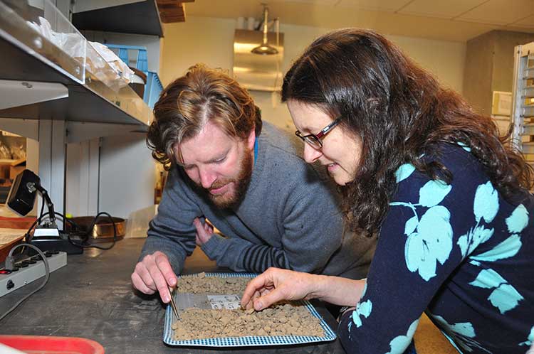
Iain McKechnie and Dana Lepofsky examine ancient herring fish bones that tell the story about how gigantic herring fisheries were for thousands of years in the Pacific Northwest. (SFU)

The herring, now dwindling on on the Pacific Coast, was once “superabundant” from Washington State through British Columbia to Alaska and that is a warning for the future, a new study says.

A team of scientists lead by Simon Fraser University argue that the archaeological record on the Pacific Coast offers a “deep time perspective” going back ten thousand years that can be a guide for future management of the herring and other fish species.

An archaeological study looked at 171 First Nations’ sites from Washington to Alaska and recovered and analyzed 435,777 fish bones from various species.

Herring bones were the most abundant and dating shows that herring abundance can be traced from about 10,700 years ago to about the mid-nineteenth century with the arrival of Europeans and the adoption of industrial harvesting methods by both settlers and some First Nations.

That means herring were perhaps the greatest food source for First Nations for ten thousand years surpassing the “iconic salmon.” Herring bones were the most frequent at 56 per cent of the sites surveyed and made up for 49 per cent of the bones at sites overall.

The study was published online Monday, February 17, 2014, in Proceedings of the National Academy of Sciences (PNAS). Simon Fraser University researchers Iain McKechnie, Dana Lepofsky and Ken Lertzman, and scientists in Ontario, Alberta and the United States are its co-authors.

The study is one of many initiatives of the SFU-based Herring School, a group of researchers that investigates the cultural and ecological importance of herring.

“By compiling the largest data set of archaeological fish bones in the Pacific Northwest Coast, we demonstrate the value of using such data to establish an ecological baseline for modern fisheries,” says Iain McKechnie. The SFU archaeology postdoctoral fellow is the study’s lead author and a recent University of British Columbia graduate.

Co-author and SFU archaeology professor Dana Lepofsky states: “Our archaeological findings fit well with what First Nations have been telling us. Herring have always played a central role in the social and economic lives of coastal communities. Archaeology, combined with oral traditions, is a powerful tool for understanding coastal ecology prior to industrial development.”

The researchers drew from their ancient data-catch concrete evidence that long-ago herring populations were consistently abundant and widespread for thousands of years. This contrasts dramatically with today’s dwindling and erratic herring numbers.

“This kind of ecological baseline extends into the past well beyond the era of industrial fisheries. It is critical for understanding the ecological and cultural basis of coastal fisheries and designing sustainable management systems today,” says Ken Lertzman, another SFU co-author. The SFU School of Resource and Environmental Management professor directs the Hakai Network for Coastal People, Ecosystems and Management.

Map of First Nations sites with fish bones
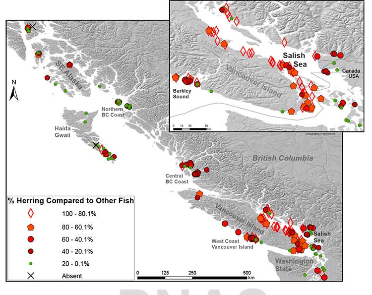
Map of First Nations’ archaeological sites with high numbers of fish bones. Herring is abundant in sites throughout the Strait of Georgia. In 71% of sites, herring makes up at least 20 per cent of the bones found at the site. (SFU/PNAS)

Heiltsuk tradition

The paper says that the abundance of herring is additionally mirrored in First Nations’ place
names and origin narratives. They give the example of the 2,400-y-old site at Nulu where herring
made up about 85 per cent of the fish found in local middens. In Heiltsuk oral tradition, it is Nulu where Raven first found herring. Another site, 25 kilometres away at the Koeye River, has only has about 10 per cent herring remains and is not associated with herring in Heiltsuk tradition.

(In an e-mail to Northwest Coast Energy News, McKechnie said “there is a paucity of archaeological data from Kitimat and Douglas Channel. There is considerable data from around Prince Rupert, the Dundas Islands and on the central coast Namu/Bella Bella/ Rivers Inlet area and in southern Haida Gwaii.”)

The study says that the archaeological record indicates that places with abundant herring were consistently harvested over time, and suggests that the areas where herring massed or spawned were more extensive and less variable in the past than today. It says that even if there were natural variations in the herring population, the First Nations harvest did not affect the species overall.

It notes:

Many coastal groups maintained family-owned locations for harvesting herring and herring roe from anchored kelp fronds, eel grass, or boughs of hemlock or cedar trees. Herring was harvested at other times of the year than the spawning period when massing in local waters but most ethnohistorical observations identify late winter and springtime spawning as a key period of harvest for both roe and fish.

The herring and herring roe were either consumed or traded among the First Nations.

Sustainable harvests encouraged by building kelp gardens,wherein some roe covered fronds were not collected, by minimizing noise and movement during spawning events, and by elaborate systems of kin-based rights and responsibilities that regulated herring use and distribution.

Industrial harvesting

Industrial harvesting and widespread consumption changed all that. Large numbers of herring were harvested to for rendering to oil or meal. By 1910, the problem was already becoming clear. In that year British Columbia prohibited the reduction of herring for oil and fertilizer. There were reports at that time that larger bays on the Lower Mainland were “being gradually deserted by the larger schools where they were formerly easily obtained.”

But harvesting continued, in 1927 the fishery on eastern Vancouver Island, Columbia, processed
31,103 tons of herring. The SFU study notes that that is roughly twice the harvest rate for 2012 and would also be about 38 per cent of the current herring biomass in the Strait of Georgia.
In Alaska, reduction of herring began in 1882 and reached a peak of 75,000 tons in 1929.

As the coastal populations dwindled, as with other fisheries, the emphasis moved to deeper water. By the 1960s, the herring populations of British Columbia and Washington had collapsed. Canada banned herring reduction entirely in 1968, Washington followed in the early 1980s.

In the 1970s, the herring population off Japan collapsed, which opened up the demand for North American roe, which targeted female herring as they were ready to spawn. That further reduced the herring population so that the roe fishery is now limited to just a few areas including parts of the Salish Sea and off Sitka and Togiak, Alaska.

The First Nations food, social and ceremonial herring fishery continues.

Government fishery managers, scientists, and local and indigenous peoples lack consensus on the cumulative consequences of ongoing commercial fisheries on herring populations. Many First Nations, Native Americans, Alaska Natives, and other local fishers, based on personal observations and traditional knowledge, hypothesize that local herring stocks, on which they consistently relied for generations, have been dramatically reduced and made more difficult to access following 20th century industrial fishing

Deep time perspective

The SFU study says that some fisheries managers are suggesting that the herring population has just shifted to other locations and other causes may be climate change and the redounding of predator populations.

But the study concludes, that:

Our data support the idea that if past populations of Pacific herring exhibited substantial variability, then this variability was expressed around a high enough mean abundance such that there was adequate herring available for indigenous fishers to sustain their harvests but avoid the extirpation of local populations.

These records thus demonstrate a fishery that was sustainable at local and regional scales over millennia, and a resilient relationship between harvesters, herring, and environmental change that has been absent in the modern era.

Archaeological data have the potential to provide a deep time perspective on the interaction between humans and the resources on which they depend.

Furthermore, the data can contribute significantly toward developing temporally meaningful ecological baselines that avoid the biases of shorter-term records.

Other universities participating in the study were the University of British Columbia, University of Oregon, Portland State University, Lakehead University, University of Toronto, Rutgers University and the University of Alberta.


RELATED:

BC First Nations Opposition to Commercial Herring Fisheries supported by DFO

Fisheries minister ignored advice from own scientists

Oil spill caused “unexpected lethal impact” on herring, study shows