West Coast “kelp highway” was the earliest route for First Peoples’ settlement of the Americas is the new scientific consensus

Most historians and archaeologists believe that the First Peoples to arrive in North America came down the West Coast on what they now call the “kelp highway.”

The review paper “The First Americans” was published this week in the prestigious journal Science.

Evidence from archaeological sites from the British Columbia coast to the southern tip of South America show that First Peoples had settled on both continents by at least 18,000 years ago, according to authors T.J. Braje at San Diego State University in San Diego, CA; T.D. Dillehay at Vanderbilt University in Nashville, TN; J.M. Erlandson at University of Oregon in Eugene, OR; R.G. Klein at Stanford University in Stanford, CA; T.C. Rick at National Museum of Natural History, Smithsonian Institution in Washington, DC.

The paper also says the DNA genomic data suggests a northeast Asian origin for Native American ancestors some time in the past 20,000 years.

(Science)

One of the key sites cited in the paper is Triquet Island in the traditional territory of the Heiltsuk Nation which has been dated to at least 14,000 years ago. Heiltsuk oral history has marked the island for generations, William Housty a member of the Heiltsuk told CBC News at the time the discovery was officially announced in April 2017, “Heiltsuk oral history talks of a strip of land in that area where the excavation took place. It was a place that never froze during the ice age and it was place where our ancestors flocked to for survival.”

The authors of the review say the new consensus on the “kelp highway” is a “dramatic intellectual turnabout” from the original idea that the first indigenous settlers followed an ice free corridor from a land bridge from Siberia down the centre of North America to form the “Clovis Culture”

The land bridge between northeast Asia and North America, commonly called Beringia, came about when sea levels fell during the last ice age. Although the original Beringia hypothesis has been disputed by some First Peoples, the paper says the Beringia hypothesis is still a factor—but much farther back in time, now about 24,000 years ago.

The paper says:

most archaeologists and other scholars now believe that the earliest Americans followed Pacific Rim shorelines from northeast Asia to Beringia and the Americas.

According to the kelp highway hypothesis, deglaciation of the outer coast of North America’s Pacific Northwest about 17,000 years ago created a possible coastal corridor rich in aquatic and terrestrial resources along the Pacific Coast, with productive kelp forest and estuary  ecosystems at sea level and no major geographic barriers

The paper says that kelp resources extended as far south as Baja California, and then—after a gap in Central America, where productive mangrove and other aquatic habitats were available—picked up again in northern Peru, where the cold, nutrient-rich waters from the Humboldt Current supported kelp forests as far south as Tierra del Fuego.

The other sites cited in the paper are

  • Huca Prieta, Peru 15,000 to 14,500 years ago
  • Paisley Caves, Oregon 14,000 years ago
  • Monte Verde, Chile 14,500 years ago
  • Page-Ladson, Florida 14,500 years ago
  • Channel Islands California 13,000 years ago
  • Quebrada Santa Julia and Quebrada Huentelauquén , Chile 13,000 years ago
  • Quebrada Tacahuay Peru 13,000 years ago
  • Quebrada Jaquay, Peru 13,000 years ago

In an earlier article in Science in August, Knut Fladmark, a professor emeritus of archaeology at Simon Fraser University who was one of the first to propose a coastal migration into the Americas back in 1979, said: “The land-sea interface is one of the richest habitats anywhere in the world,” noting that early Americans knew how to take full advantage of its abundant resources.

Testing the kelp highway hypothesis is challenging, the scientists say, because much of the archaeological evidence would have been submerged by rising seas since the end of the last “glacial maximum,” about 26,500 years ago.

The earlier that the First Peoples arrived, that means the land they originally settled is now the further offshore from the current coast  (land which is now likely also at greater depth under the current ocean). So the review says that finding the evidence means that, “enlarging already vast potential search areas on the submerged continental shelf.”

The authors say:

Although direct evidence of a maritime pre-Clovis dispersal has yet to emerge, recent discoveries confirm that late Pleistocene archaeological sites can be found underwater. Recent discoveries at the Page-Ladson site, in Florida produced 14,500-year-old butchered mastodon bones and chipped stone tools in the bottom of Florida’s Aucilla River.

The report says that “Several multidisciplinary studies are currently mapping and exploring the submerged landscapes of North America’s Pacific and Gulf of Mexico coasts, searching for submerged sites. .

In British Columbia, those studies (pdf) include the discovery by Daryl Fedje, an archaeologist at the University of Victoria and the Hakai Institute of 29 footprints on Quadra Island. A piece of wood embedded in a footprint’s fill provided the radiocarbon date of 13,200 years ago and the spear points lying and a cluster of bear bones at Gaadu Din cave on the Haida Gwaii dated to 12,700 years ago.

The review says that for much of the 20th century, most archaeologists believed humans first colonized the Americas about 13,500 years ago via the overland route that crossed Beringia and followed a long and narrow, mostly ice-free corridor to the vast plains of central North America. There,  according to the earlier theories, Clovis people and their descendants hunted large game and spread rapidly through the New World.

This was initially confirmed by twentieth-century discoveries of distinctive Clovis artifacts throughout North America. Some finds associated with mammoth or mastodon kill sites, supported this “Clovis-first” model.

The early studies decided then that “North America’s coastlines and their rich marine, estuarine, riverine, and terrestrial ecosystems were peripheral to the story of how and when the Americas were first settled by humans.”

Now the recent work along the Pacific coastlines of North and South America has revealed that these environments were settled early and continuously, providing a rich diversity of subsistence options and technological resources for New World hunter-gatherers.

A detail of the map from Science shows how off from the current coast the ancient shorelines reached (Science)

At the moment,  there is little evidence on the coast so far of the kind of  stone tools and fishtail points that had previously provided a road map that archaeologists used to trace the spread of “Clovis” Paleoindians throughout the Americas. Such a roadmap is lacking for “pre-Clovis” sites on the coast.

One proposal is that distinctive stemmed (“tanged”) chipped-stone projectile points, crescents (lunate-shaped), and leaf-shaped bifaces found in Japan, northeast Asia, western North America, and South America could be potential markers of an earlier coastal migration and  ties to Ice Age peoples in East Asia.

The problem of finding final proof of the kelp highway is that the First Peoples followed a coastal route from Asia to the Americas, so that finding evidence for their earliest settlements will require careful consideration of the effects of sea level rise and coastal landscape evolution on local and regional archaeological records.

The scientists note that around the globe, evidence for coastal occupations between  about 50,000 and 15,000 years ago are rare because of postglacial sea level rise, marine erosion, and shorelines that have migrated tens or even hundreds of kilometers from their locations at the ice age glacial maximum.

They say overcoming these obstacles requires interdisciplinary research focused on coastal areas with relatively steep offshore bathymetry, formerly glaciated areas where ancient shorelines have not shifted so dramatically, or the submerged landscapes that are one of the last frontiers for archaeology in the Americas

 

Rebar in hatcheries could distort navigation sense in young salmon and trout

Iron and steel in hatcheries, including rebar supporting concrete structural elements, could be distorting the ability of salmon and trout to navigate using the earth’s magnetic fields according to a study released today by Oregon State University.

The exposure to iron and steel distorts the magnetic field around the young fish, affecting the fish’s “map sense” and their ability to navigate, said Nathan Putman, who led the study while working as a postdoctoral researcher in the Oregon Department of Fisheries and Wildlife, part of OSU’s College of Agricultural Sciences.

For decades, scientists have studied how salmon find their way across vast stretches of ocean.

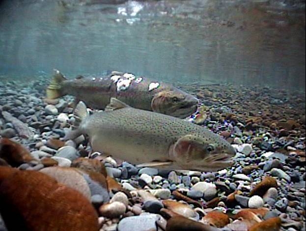
Steelhead.
Spawning Steelhead (Oregon State University).

In a study last year, Putman and other researchers presented evidence of a correlation between the oceanic migration patterns of salmon and drift of the Earth’s magnetic field. They confirmed the ability of salmon to navigate using the magnetic field in experiments at the Oregon Hatchery Research Center.

That earlier research confirmed that fish possess a map sense, determining where they are and which way to swim based on the magnetic fields they encounter.

“The better fish navigate, the higher their survival rate,” said Putman, who conducted the research at the Oregon Hatchery Research Center in the Alsea River basin last year. “When their magnetic field is altered, the fish get confused.”

Subtle differences in the magnetic environment within hatcheries could help explain why some hatchery fish do better than others when they are released into the wild, Putman said.

The study suggests that stabilizing the magnetic field by using alternative forms of hatchery construction may be one way to produce a better yield of fish, he said.

“It’s not a hopeless problem,” he said. “You can fix these kinds of things. Retrofitting hatcheries with non-magnetic materials might be worth doing if it leads to making better fish.”

The new findings follow the  earlier research by Putman and others that confirmed the connection between salmon and the Earth’s magnetic field.

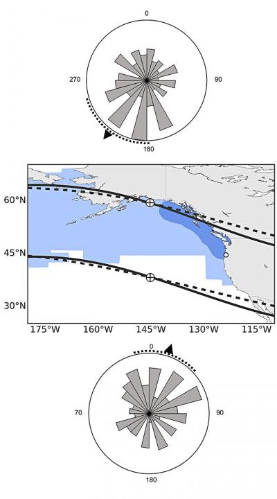
Researchers exposed hundreds of juvenile Chinook salmon to different magnetic fields that exist at the latitudinal extremes of their oceanic range.

Fish responded to these “simulated magnetic displacements” by swimming in the direction that would bring them toward the center of their marine feeding grounds.

Putman repeated that experiment with the steelhead trout and achieved similar results. He then expanded the research to determine if changes to the magnetic field in which fish were reared would affect their map sense. One group of fish was maintained in a fiberglass tank, while the other group was raised in a similar tank but in the vicinity of iron pipes and a concrete floor with steel rebar, which produced a sharp gradient of magnetic field intensity within the tank. Iron pipes and steel reinforced concrete are common in fish hatcheries.

The scientists monitored and photographed the juvenile steelhead, called parr, and tracked the direction in which they were swimming during simulated magnetic displacement experiments. The steelhead reared in a natural magnetic field adjusted their map sense and tended to swim in the same direction. But fish that were exposed to the iron pipes and steel-reinforced concrete failed to show the appropriate orientation and swam in random directions.

More research is needed to determine exactly what that means for the fish. The loss of their map sense could be temporary and they could recalibrate their magnetic sense after a period of time, Putman said. Alternatively, if there is a critical window in which the steelhead’s map sense is imprinted, and it is exposed to an altered magnetic field then, the fish could remain confused forever, he said.

“There is evidence in other animals, especially in birds, that either is possible,” said Putman, who now works for the National Oceanic and Atmospheric Administration. “We don’t know enough about fish yet to know which is which. We should be able to figure that out with some simple experiments.”

Map showing the ocean range of Chinook salmon and how the fish sense magnetic fields.  Fish with a "northern orientation" swim south and vice versa. (University of Oregon)
Map showing the ocean range of Chinook salmon and how the fish sense magnetic fields. Fish with a “northern orientation” swim south and vice versa. (Oregon State University)

Putman’s findings were published this week in the journal Biology Letters. The research was funded by Oregon Sea Grant and the Oregon Department of Fish and Wildlife, with support from Oregon State University. Co-authors of the study are OSU’s David Noakes, senior scientist at the Oregon Hatchery Research Center, and Amanda Meinke of the Oregon Hatchery Research Center.

While BC is told refining heavy crude is uneconomic, planning for US west coast refineries going ahead

Supporters of David Black’s Kitimat Clean project to build a refinery about 25 kilometres north of Kitimat have been met by skepticism by experts and economists from the Canadian oil patch who keep telling the people of northwestern British Columbia that to create jobs by adding value to Alberta crude is uneconomic.

The Americans, apparently, have a different view, with plans announced for shipping projects in Washington State that could handle not only oil shale crude from the Bakken Formation in the Dakotas but also Canadian “heavy crude” aimed at refineries in Californa, refineries that would require new or renovated facilities.

So let’s add another question to northwest BC’s skepticism about the Alberta oil patch. Why is uneconomic to refine in Alberta or BC, but apparently increasingly economic to refine in California given the cost of building or rebuilding facilites?

Opponents of the Northern Gateway pipeline have always speculated that any bitumen exported from Kitimat could end up in California rather than markets in Asia.

According to reports, the Vancouver, Washington,  project plans to load the bitumen on barges for shipment to California, which is likely to cause a storm of controversy with environmental groups in both states, especially if a barge, which has almost no controls compared to a tanker, foundered and ended up on the coast.

The New York Times, on Oct. 31, looked at the issue in a report Looking for a Way Around Keystone XL, Canadian Oil Hits the Rails. The issue of moving crude by rail has been gaining traction in recent months, with growing opposition to pipeline projects. But where do those long trains of tank cars full of crude go?

Times reporter Clifford Kraus says:

The developing rail links for oil sands range across Canada and over the border from the Gulf Coast to Washington and California. Railways can potentially give Canadian producers a major outlet to oil-hungry China, including from refineries in Washington and California.

According to the Times, the plans call for two Canadian export terminals.

“We want to diversify our markets beyond just moving our product south,” said Peter Symons, a spokesman for Statoil, a Norwegian oil giant that has signed contracts to lease two Canadian oil loading terminals. “We can get that product on a ship and get it to premium markets in Asia.”

The Americans, on the other hand, are looking toward refineries.

Again the Times report says:

Several Washington and Oregon refiners and ports are planning or building rail projects for Canadian heavy crude as well as light oil from North Dakota. The Texas refinery giant Tesoro and the oil services company Savage have announced a joint venture to build a $100 million, 42-acre oil-handling plant in the Port of Vancouver on the Columbia River that could handle 380,000 barrels of oil each day if permits are granted.

Not that everything is clear sailing. The Times says there is resistance to a plan to refine heavy crude in California.

The city of Benicia, Calif., last month delayed the granting of a permit for Valero Energy’s planned rail terminal at its refinery by deciding to require an environmental impact report after residents expressed concerns that Valero would use the terminal to import Canadian oil sands crude.

Tesoro logoTesoro and its partner Savage announced the Vancouver, Washington project in April.

With access to rail and existing marine infrastructure, the Port of Vancouver is uniquely positioned to serve as a hub for the distribution of North American crude oil to West Coast refining centers. Tesoro and Savage are ideal partners for this project, having already operated in close partnership for almost ten years on the West Coast. The Tesoro-Savage Joint Venture’s combined capabilities, experience and resources are expected to create substantial benefits for the Port and the Vancouver community in the form of sustainable revenue to the Port and local jobs associated with the facility’s construction and operation.

The Tesoro news release quotes Greg Goff, President and CEO of Tesoro.

Building upon the recent success of the rail unloading facility at our Anacortes, Wash., refinery, where we have been delivering Mid-Continent crude oil via unit train in an environmentally sound and cost-effective manner, this project is the ideal next step for Tesoro as we drive additional feedstock cost advantage to the remaining refineries in our West Coast system.

While the Tesoro April release doesn’t specifically mention heavy crude or bitumen from Alberta, in August, Reuters reporting on a Tesoro results conference call said, the project would “supply cheaper U.S. and Canadian crude to refineries all along the West Coast – both its own and those run by competitors.”

The project, which would initially have capacity of 120,000 barrels a day and could be expanded to 280,000 BPD, is the biggest so far proposed to help Pacific Coast refineries tap growing output of inland U.S. and Canadian heavy crudes.

The project, where North Dakota Bakken and Canadian crude would travel by rail to the marine facility in Vancouver, Washington and then barged to refining centers, is being planned with joint venture partner Savage Companies.

In September, Petroleum News reported

The Port of Vancouver facility will have “a lot of flexibility and capability to take different types of crudes, from heavy Canadian crudes to crudes from the Mid-Continent… So we will source crude from where the best place is,” Goff said on Aug. 2. “The facility also was designed to supply the entire West Coast… We can go from as far away as Alaska to Southern California, in those refineries, which we intend to do.”

Reuters also reported

Regulators also are considering Valero’s permit request for a 60,000 bpd rail facility at its 78,000 bpd Wilmington refinery near Los Angeles, but in June the area pollution regulator said it would take 18 months to finish an environmental review, permitting and construction.
Alon Energy USA also is seeking permits for a rail facility at its Southern California refining system, which shut down late last year as losses mounted on high imported crude costs and low asphalt demand. The company hopes to get those permits by year-end.
Valero spokesman Bill Day on Friday declined to say whether Valero would be interested in tapping inland and Canadian crude through the Tesoro project, but noted that the company values flexibility in getting cheaper crudes to its refineries.

Asked today about the New York Times report, (at the time of his regular news conference, he hadn’t read the story) Skeena Bulkley Valley MP Nathan Cullen said, “I mean there’s been so much uncertainty, in large part created by this government with respect to moving oil anywhere. This is another proposal, it seems every week you wake up, open the papers and there’s another proposal. Some of them are legitimate, some of them are snake oil.

“This one I’m not familiar with, so I can’t make specific comments on it, I will certainly look at it because I’m very interested in energy on the west coast. I’d have to see, given the government we have in Ottawa right now, they’re not friends to communities and First Nations and certainly not friends to the oil sector because they keep causing so much concern within the broader public and hurt the companies’ ability to gain social licence to get a project going.”

What is it about Douglas Channel islands? Now a US agency has added a “Douglas Island”

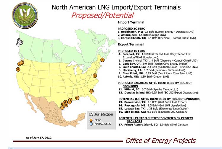
US FERC Map of LNG terminals in North America
Map from the United States Federal Energy Regulatory Commission showing LNG export terminal projects in North America (FERC)

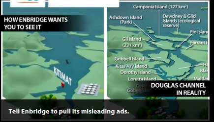
What is it about the islands in Douglas Channel? First, Enbridge gets in to a lot of hot water, so to speak, for erasing the islands in Douglas Channel in an animation promoting the Northern Gateway Pipeline.  See for example The Vancouver Sun on back on Aug. 16, 2012, when it picked up a story from the Times Colonist – Enbridge map sinks islands, angers critics.   The controversial video segment showed Douglas Channel wide open for navigation, rather than marked with about one thousand square kilometres of mountainous islands. Map of Douglas Channel Islands from Leadnow.ca This map, created by the Leadnow.ca and  Sumofus.org websites was widely used by the media to show the difference.  Enbridge later amended its video with a disclaimer that it is “broadly representational.” A video by Shortt and Epic Productions “This is Not An Enbridge animation” showing the beauty of northwestern BC quickly went viral.

As this was happening, the United States government Federal Energy Regulatory Commission issued a map that shows Liquified Natural Gas import and export terminals across North America, a map that adds an island to the Channel–“Douglas Island.”

In fact, the map manages to get a lot about Canadian LNG projects wrong. It locates the BC LNG project on the non-existent Douglas Island. The company’s name Douglas Channel Energy Partnership actually gives the proper location this way

 south of the Moon Bay Marina, within the District of Kitimat and the asserted traditional territory of the Haisla Nation. The site is approximately 10 km southwest of Kitimat and 7 km north of Bees Cove Indian Reserve 6 (Bish Cove)

The small cove where BCLNG will put its barges to create the LNG is often locally called North Cove.

The FERC map also misplaces the Shell LNG project, now known as LNGCanada, in Prince Rupert, even though Shell confirmed the Kitimat location on May 15, 2012. It also calls it Prince Rupert Island, although the town of Prince Rupert is actually located on Kaien Island.

The map does apparently get the KM LNG project somewhat correct, attributing it to Apache Canada, but leaving off Apache’s partners, Encana and EOG.

The map recently also appeared on the website of Oregon Public Broadcasting in an article Five Keys To The Pacific Northwest’s Natural Gas Export Debate by reporter Amelia Templeton, which outlines the growing controversy over the plans to export US LNG through Coos Bay, Oregon via the Jordan Cove Project.

It appears that in Oregon, the Coos Bay LNG project is becoming as controversial as the Northern Gateway project is in Canada.

The issues outlined by Templeton include the threat of expropriation (called “eminent domain” in the US and also a key issue in the debate over the Keystone XL pipeline on the plains).  There are arguments on jobs versus the environment, especially the perceived threat to wild rivers and salmon spawning grounds. Finally one issue that is lower on the agenda in northwestern BC but a big worry in Oregon, the potential for a devastating earthquake along the Cascadia fault.

During the NEB hearings on the KM LNG (Apache/EOG/Encana) project in June, 2011, many of the  “expert” witnesses urged that that first Kitimat project go ahead quickly because of perceived competition from Oregon.

Unlike in Oregon, LNG projects are generally perceived positively in the northwest and all three are going ahead, although not as quickly as originally planned due to market volatility among prime potential customers in Asia.


Kitimat LNG on the agenda at Houston conference

Energy

The Kitimat LNG projects have been added to a conference on LNG exports in Houston, Texas on December 1.

Zeus Events, the commercial organizer of the conference tweeted this morning  “Kitimat #LNG Export project added to N. American LNG Exports conference.”

The conference agenda describes the presentation this way:

Kitimat LNG Export Project Update
Kitimat LNG Project, Speaker TBA

Apache is developing the most advanced LNG export project in North America at Kitimat, British Columbia. Construction is expected to begin in early 2012, with operations to start in 2015. The representative has been asked to describe the project and provide an update, discussing what it will mean for British Columbia gas producers.

The conference website describes it as:

Proposals to liquefy and export North American gas as LNG have grown more numerous and controversial since our 2010 conference. At last count, ten liquefaction and export projects have been proposed on both coasts of North America. Analysts warn, however, that the United States is preparing to export its clean, abundant natural gas to countries like China, where it will be used for transportation fuel, while the U.S. will continue to import high-cost crude for its transportation.

This year’s conference will expand on our 2010 meeting to address political issues such as FERC’s willingness to approve export plant construction permits as well as examine new proposals. Costs, political hurdles and regulatory issues will be discussed.

The Oregon projects, seen by analysts at the June National Energy Board hearings as Kitimat’s chief rival are also on the agenda at the conference.