In 1999, a tropical fungus called by scientists Cryptococcus gattii unexpectedly appeared on Vancouver Island. Spores from the fungus can cause a sometimes fatal pneumonia-like illness in humans, cats, dogs and marine mammals, including porpoises and dolphins. There is one reported case of the fungus infecting a great blue heron.
Normally, the fungus is most common in Papua New Guinea, Australia and South America. Today it is also found growing in the coastal forests and shoreline areas of southern coastal British Columbia, Washington and Oregon.
A study, released today, supported by the US Centres for Disease Control and Prevention (CDC) is described as tracking multiple pieces of a puzzle. It suggests that a singular event, like a natural disaster, could have been the missing piece that brought the whole picture together.
The scientists, microbiologist Arturo Casadevall, MD, PhD, Chair of Molecular Microbiology and Immunology at the Bloomberg School at Johns Hopkins University, and epidemiologist David Engelthaler, PhD, of the Translational Genomics Research Institute, Flagstaff, Arizona, suggest that a series of events brought the fungus to BC culminating in its possible spread by the tsunami unleashed by the 1964 magnitude 9.2 earthquake in Anchorage, Alaska. The scientists wrote that the tsunami idea seemed to fit the “when, where, and why” of this disease emergence.
The US CDC has tracked more than 300 C. gattii fungal infections in the Canadian and U.S. Pacific Northwest region since the first case on Vancouver Island in 1999. Prior to that time, infections with this fungus had been confined almost entirely to Papua New Guinea, Australia, and South America. The fungus typically infects people through inhalation. It can cause a pneumonia-like illness, and may also spread to the brain, causing a potentially fatal meningoencephalitis. Although the disease is fairly rare and few infected people become ill, for those who become infected, published case reports suggest an overall mortality rate of more than 10 percent.
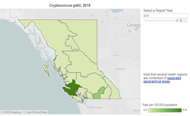
Incidence of Cryptococcus gattii infection in BC (BCCDC)
The British Columbia Centre for Disease Control (BCCDC) says Vancouver Island has one of the highest rates of infection in the world. Each year in B.C. from 10 to 25 people become sick from cryptococcosis and about 16 per cent die from the disease.
In the Northern Health region, however, only one case, in 2017, has been reported since 2009 and that was in the Northern Interior region.
The BCDC says the fungal infection can take several months to incubate after exposure. Only a few people exposed to the spores will become ill. Cryptococcus gattii is a reportable disease in British Columbia.
The new study is suggesting that the fungus first traveled in ships’ ballast tanks. After the Panama Canal opened in 1914, shipping increased significantly between Atlantic and Pacific ports.
The scientists believe that in South America, the fungus began washing from local rivers into shore waters. Then ships loaded ballast water, which research has shown is a common mode of transport for invasive species. The ballast water then spread the fungus to North American waters. Ships in those days routinely took on such ballast water in one port and simply discharged it, without treatment, in another.
How the tropical pathogen established itself in such a cool northern area was originally unclear. Theories have included global warming and the import of tropical eucalyptus trees.
The new study proposes that once in the North Pacific the fungus went unnoticed until the 1964 earthquake brought the fungus widely ashore and into coastal forest area.
It then took several decades for the fungus to evolve in its new habitat so that it could survive and then thrive first in coastal Vancouver Island, then across the island to the Lower Mainland and down to Washington and Oregon.
Casadevall says, “The big new idea here is that tsunamis may be a significant mechanism by which pathogens spread from oceans and estuarial rivers onto land and then eventually to wildlife and humans, If this hypothesis is correct, then we may eventually see similar outbreaks of C. gattii, or similar fungi, in areas inundated by the 2004 Indonesian tsunami and 2011 Japanese tsunami.”
The Alaskan Earthquake was felt as far as 4,500 kilometres away. Effects were recorded on the Hawaiian Islands. The waves reported in nearby Shoup Bay, Alaska were 67 metres causing significant shoreline devastation. At Seward, Alaska, the tsunami wave was 9.2 metres. At Port Alberni it was 6.4 metres. North of Kitimat, at Ketchikan, the wave was just 0.6 metres and at Prince Rupert, 1.4 metres. There are no figures for Kitimat, but with no damage reported, it is likely that the wave was somewhere around a metre.
The tsunami continued south, affecting much of the coastline of western North America, even causing several deaths on the beaches of northern California.
Several hours after the earthquake, multiple waves flowed up Alberni Inlet, cresting at eight metres and striking the Port Alberni region, washing away 55 homes and damaging nearly 400 others
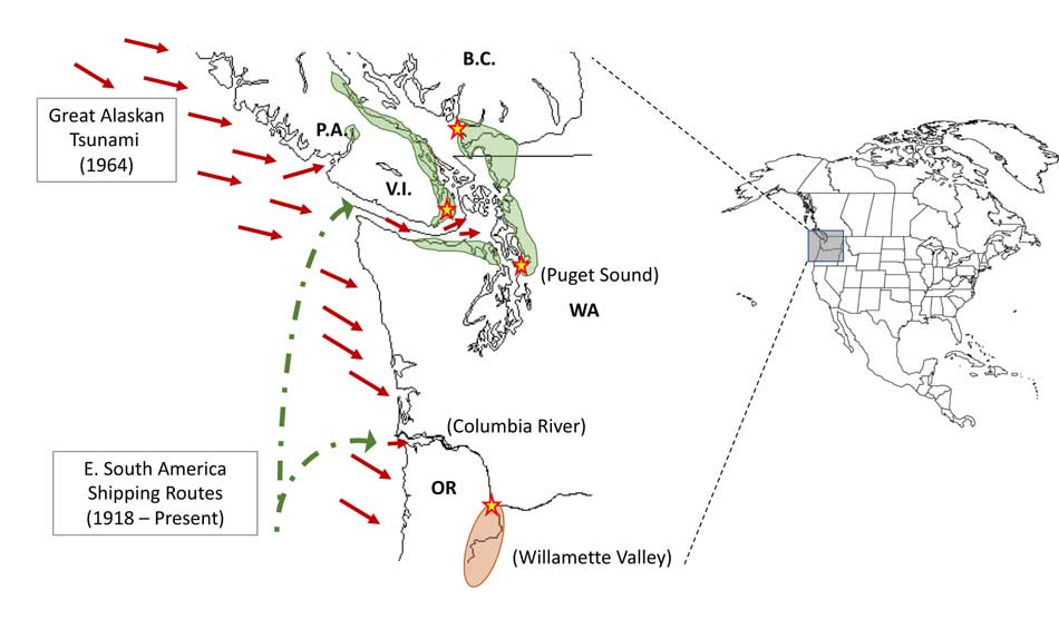
The study retrieved multiple fungus samples from the forests in the Port Alberni region. Studies show there are multiple infected sea mammals in the port’s waterways. Human and terrestrial and marine animal cases have also been reported along the western coast of Vancouver Island. The results suggest that the contamination of the Port Alberni region may be from the 1964 tsunami rather than from terrestrial dispersal from the eastern side of Vancouver Island.
Map showing where the 1964 tsunami could have deposited the fungus (Ecological and Evolutionary Science)
The early environmental analyses in British Columbia identified that the fungus was found in soils and trees in the coastal Douglas fir forests and in coastal Western Hemlock forests bordering the coastal Douglas fir forest. While these studies were “limited in geographical space” the contaminated landscapes were also the known locations of human and animal infections. Further ecological analyses have identified higher levels of soil and tree contamination at low-lying elevations close to sea level.
The researchers now hope to continue testing their hypothesis with detailed analyses of C. gattii in soils within and outside tsunami-inundated areas of the Pacific Northwest. They then want to compare the British Columbia fungus with DNA collected from other parts of the world.–to see if the same C. gattii subtypes found in Brazil and the Pacific Northwest are more widely present in seawaters around ports.
The paper: “On the emergence of Cryptococcus gattii in the Pacific Northwest: ballast tanks, tsunamis and black swans” by David Engelthaler and Arturo Casadevall is in the journal Ecological and Evolutionary Science
BCDC defintion Cryptococcus is a tiny (microscopic) yeast-like fungus. A species of this fungus, called Cryptococcus gattii, has been living on trees and in the soil on the east coast of Vancouver Island since at least 1999. More recently it has also been found in the Vancouver Coastal and Fraser Health regions. Infrequently, people and animals (e.g. cats, dogs, llamas, porpoises) exposed to this fungus become sick with cryptococcal disease (or cryptococcosis). Cryptococcosis can affect the lungs (pneumonia) and nervous system (meningitis) in humans. It affects people with healthy and weakened immune system. In rare cases, this disease can be fatal.
Many people will be exposed to the fungus sometime during their lives and most of these will not get sick. In people who become ill, symptoms appear many months after exposure.
Symptoms of cryptococcal disease include:
Prolonged cough (lasting weeks or months)
Shortness of breath
Headache
Vomiting
Fever
Weight loss
If symptoms occur, the disease can cause pneumonia, meningitis, nodules in the lungs or brain, or skin infection.
People are advised to see their doctor if they live in or visit an area where the fungus can be found and experience these symptoms.
Most historians and archaeologists believe that the First Peoples to arrive in North America came down the West Coast on what they now call the “kelp highway.”
Evidence from archaeological sites from the British Columbia coast to the southern tip of South America show that First Peoples had settled on both continents by at least 18,000 years ago, according to authors T.J. Braje at San Diego State University in San Diego, CA; T.D. Dillehay at Vanderbilt University in Nashville, TN; J.M. Erlandson at University of Oregon in Eugene, OR; R.G. Klein at Stanford University in Stanford, CA; T.C. Rick at National Museum of Natural History, Smithsonian Institution in Washington, DC.
The paper also says the DNA genomic data suggests a northeast Asian origin for Native American ancestors some time in the past 20,000 years.
(Science)
One of the key sites cited in the paper is Triquet Island in the traditional territory of the Heiltsuk Nation which has been dated to at least 14,000 years ago. Heiltsuk oral history has marked the island for generations, William Housty a member of the Heiltsuk told CBC News at the time the discovery was officially announced in April 2017, “Heiltsuk oral history talks of a strip of land in that area where the excavation took place. It was a place that never froze during the ice age and it was place where our ancestors flocked to for survival.”
The authors of the review say the new consensus on the “kelp highway” is a “dramatic intellectual turnabout” from the original idea that the first indigenous settlers followed an ice free corridor from a land bridge from Siberia down the centre of North America to form the “Clovis Culture”
The land bridge between northeast Asia and North America, commonly called Beringia, came about when sea levels fell during the last ice age. Although the original Beringia hypothesis has been disputed by some First Peoples, the paper says the Beringia hypothesis is still a factor—but much farther back in time, now about 24,000 years ago.
The paper says:
most archaeologists and other scholars now believe that the earliest Americans followed Pacific Rim shorelines from northeast Asia to Beringia and the Americas.
According to the kelp highway hypothesis, deglaciation of the outer coast of North America’s Pacific Northwest about 17,000 years ago created a possible coastal corridor rich in aquatic and terrestrial resources along the Pacific Coast, with productive kelp forest and estuary ecosystems at sea level and no major geographic barriers
The paper says that kelp resources extended as far south as Baja California, and then—after a gap in Central America, where productive mangrove and other aquatic habitats were available—picked up again in northern Peru, where the cold, nutrient-rich waters from the Humboldt Current supported kelp forests as far south as Tierra del Fuego.
The other sites cited in the paper are
Huca Prieta, Peru 15,000 to 14,500 years ago
Paisley Caves, Oregon 14,000 years ago
Monte Verde, Chile 14,500 years ago
Page-Ladson, Florida 14,500 years ago
Channel Islands California 13,000 years ago
Quebrada Santa Julia and Quebrada Huentelauquén , Chile 13,000 years ago
Quebrada Tacahuay Peru 13,000 years ago
Quebrada Jaquay, Peru 13,000 years ago
In an earlier article in Science in August, Knut Fladmark, a professor emeritus of archaeology at Simon Fraser University who was one of the first to propose a coastal migration into the Americas back in 1979, said: “The land-sea interface is one of the richest habitats anywhere in the world,” noting that early Americans knew how to take full advantage of its abundant resources.
Testing the kelp highway hypothesis is challenging, the scientists say, because much of the archaeological evidence would have been submerged by rising seas since the end of the last “glacial maximum,” about 26,500 years ago.
The earlier that the First Peoples arrived, that means the land they originally settled is now the further offshore from the current coast (land which is now likely also at greater depth under the current ocean). So the review says that finding the evidence means that, “enlarging already vast potential search areas on the submerged continental shelf.”
The authors say:
Although direct evidence of a maritime pre-Clovis dispersal has yet to emerge, recent discoveries confirm that late Pleistocene archaeological sites can be found underwater. Recent discoveries at the Page-Ladson site, in Florida produced 14,500-year-old butchered mastodon bones and chipped stone tools in the bottom of Florida’s Aucilla River.
The report says that “Several multidisciplinary studies are currently mapping and exploring the submerged landscapes of North America’s Pacific and Gulf of Mexico coasts, searching for submerged sites. .
In British Columbia, those studies (pdf) include the discovery by Daryl Fedje, an archaeologist at the University of Victoria and the Hakai Institute of 29 footprints on Quadra Island. A piece of wood embedded in a footprint’s fill provided the radiocarbon date of 13,200 years ago and the spear points lying and a cluster of bear bones at Gaadu Din cave on the Haida Gwaii dated to 12,700 years ago.
The review says that for much of the 20th century, most archaeologists believed humans first colonized the Americas about 13,500 years ago via the overland route that crossed Beringia and followed a long and narrow, mostly ice-free corridor to the vast plains of central North America. There, according to the earlier theories, Clovis people and their descendants hunted large game and spread rapidly through the New World.
This was initially confirmed by twentieth-century discoveries of distinctive Clovis artifacts throughout North America. Some finds associated with mammoth or mastodon kill sites, supported this “Clovis-first” model.
The early studies decided then that “North America’s coastlines and their rich marine, estuarine, riverine, and terrestrial ecosystems were peripheral to the story of how and when the Americas were first settled by humans.”
Now the recent work along the Pacific coastlines of North and South America has revealed that these environments were settled early and continuously, providing a rich diversity of subsistence options and technological resources for New World hunter-gatherers.
A detail of the map from Science shows how off from the current coast the ancient shorelines reached (Science)
At the moment, there is little evidence on the coast so far of the kind of stone tools and fishtail points that had previously provided a road map that archaeologists used to trace the spread of “Clovis” Paleoindians throughout the Americas. Such a roadmap is lacking for “pre-Clovis” sites on the coast.
One proposal is that distinctive stemmed (“tanged”) chipped-stone projectile points, crescents (lunate-shaped), and leaf-shaped bifaces found in Japan, northeast Asia, western North America, and South America could be potential markers of an earlier coastal migration and ties to Ice Age peoples in East Asia.
The problem of finding final proof of the kelp highway is that the First Peoples followed a coastal route from Asia to the Americas, so that finding evidence for their earliest settlements will require careful consideration of the effects of sea level rise and coastal landscape evolution on local and regional archaeological records.
The scientists note that around the globe, evidence for coastal occupations between about 50,000 and 15,000 years ago are rare because of postglacial sea level rise, marine erosion, and shorelines that have migrated tens or even hundreds of kilometers from their locations at the ice age glacial maximum.
They say overcoming these obstacles requires interdisciplinary research focused on coastal areas with relatively steep offshore bathymetry, formerly glaciated areas where ancient shorelines have not shifted so dramatically, or the submerged landscapes that are one of the last frontiers for archaeology in the Americas
Scientists have identified a new species of a strange marine mammal group that lived on the Pacific Coast between 33 million years ago and 10 million years ago. The new specimens — from at least four individuals — were recovered from Unalaska, in theAleutians.
The Desmostylians, unlike other marine mammals species alive today — such as whales, seals and sea cows –are extinct. The researchers call them “desmos” for short. Unlike whales and seals, but like manatees, desmos were vegetarians
The desmos are found from Baja, California, up along the west coast of North America, around the Alaska Peninsula, the storm-battered Aleutian Islands, to Russia’s Kamchatka Peninsula and Sakhalin Island, to the Japanese islands
Their strange columnar teeth and odd style of eating don’t occur in any other mammal. They rooted around coastlines, ripping up vegetation, such as marine algae, sea grass and other near-shore plants.
The new species, 23 million years old was a big, hippo-sized animal with a long snout and tusks, It has a unique tooth and jaw structure that indicates it was not only a vegetarian, but literally sucked vegetation from shorelines like a vacuum cleaner, said vertebrate paleontologist and study co-author Louis L. Jacobs, Southern Methodist University, Dallas.
They probably swam like polar bears, using their strong front limbs to power along. On land, they would have had the lumbering gait of a sloth.
A large, stocky-limbed mammal, desmos’ modern relatives remain a mystery. Scientists have previously linked the animals perhaps to manatees, horses or elephants. Adult desmostylians were large enough to be relatively safe from predators.
The identification of a new species belonging to Desmostylia has intensified the rare animal’s brief mysterious journey through prehistoric time, according to the new study.
While alive, the newly discovered creatures lived in what is now Unalaska’s Dutch Harbor.
“The new animal — when compared to one of a different species from Japan — made us realize that desmos do not chew like any other animal,” said Jacobs, a professor of earth sciences. “They clench their teeth, root up plants and suck them in.”
To eat, the animals buttressed their lower jaw with their teeth against the upper jaw, and used the powerful muscles that attached there, along with the shape of the roof of their mouth, to suction-feed vegetation from coastal bottoms. Big muscles in the neck would help to power their tusks, and big muscles in the throat would help with suction.
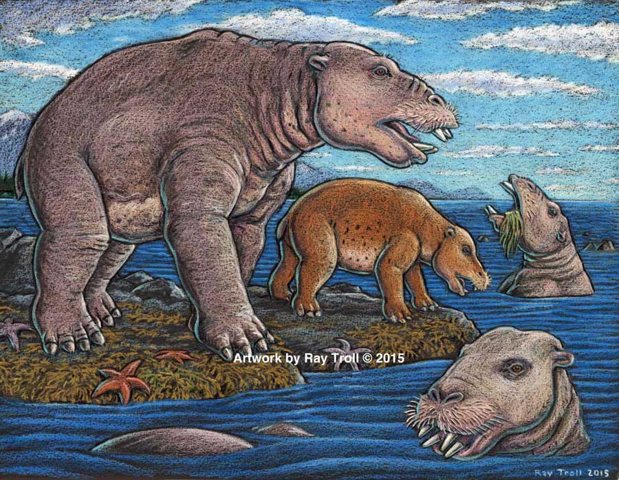
Discovery of the new genus and species that resembled a hippo and swam like a bear, from Unalaska indicates the desmostylian group was a successful group that was larger and more diverse than previously known. (Artist: Ray Troll)
“No other mammal eats like that,” Jacobs said. “The enamel rings on the teeth show wear and polish, but they don’t reveal consistent patterns related to habitual chewing motions.”
The new specimens also represent a new genus — meaning desmostylians in the same family diverged from one anoher in key physical characteristics, particularly the tooth and jaw structure, said Jacobs, who is one of 10 scientists collaborating on the research.
Discovery of a new genus and species indicates the desmostylian group was larger and more diverse than previously known, said paleontologist and co-author Anthony Fiorillo, vice president of research and collections and chief curator at the Perot Museum of Nature and Science, Dallas, and an adjunct research professor at SMU.
“Our new study shows that though this group of strange and extinct mammals was short-lived, it was a successful group with greater biodiversity than had been previously realized,” Fiorillo said.
Compared to other mammals, desmos were latecomers and didn’t appear on earth until fairly recently — 33 million years ago. Also unusual for mammals, they survived a mere 23 million years, dying out 10 million years ago.
The research was funded by the Perot Museum of Nature and Science, U.S. National Park Service – Alaska Region Office, and SMU’s Institute for the Study of Earth and Man.
The newest desmo made its home on Unalaska Island, the farthest north of any occurrence of the group, which only lived along the shores of the North Pacific.
“That’s the only place they’re known in the world,” Jacobs said. The Unalaska fossils represent at least four individuals, and one is a baby.
“The baby tells us they had a breeding population up there,” Jacobs said. “They must have stayed in sheltered areas to protect the young from surf and currents.”
In addition, “the baby also tells us that this area along the Alaska coast was biologically productive enough to make it a good place for raising a family,” said Fiorillo.
Just as cattle assemble in a herd, and a group of fish is a school, multiple desmostylians constitute a “troll” — a designation selected by Jacobs to honor Alaskan Ray Troll, the artist who has depicted desmos most.
The first Unalaska fossils were discovered in the 1950s in a rock quarry during U.S. Geological Survey mapping.
Others found more recently were on display at the Ounalashka Corporation headquarters. Those specimens were offered to Fiorillo and Jacobs for study after Fiorillo gave a public presentation to the community on his work in Alaska.
“The fruits of that lecture were that it started the networking with the community, which in turn led us to a small, but very important collection of fossils that had been unearthed in the town when they built a school a few years earlier,” Fiorillo said. “The fossils were shipped to the Perot Museum of Nature and Science for preparation in our lab and those fossils are the basis for our work now.”
From there, the researchers discovered that the fossils were a new genus and species.
The authors report their discoveries in a special volume of the international paleobiology journal, Historical Biology. The article published online Oct. 1 at http://bit.ly/1PQAHZJ
The researchers named the new mammal Ounalashkastylus tomidai. “Ounalashka,” means “near the peninsula” in the Aleut language of the indigenous people of the Aleutian Islands.
“Stylus” is from the Latin for “column” and refers to the shape of cusps in the teeth.
“Tomida” honors distinguished Japanese vertebrate paleontologist Yukimitsu Tomida.
The article appears in a special volume of Historical Biology to honor the career accomplishments of Tomida upon his retirement from the Department of Geology and Paleontology in Tokyo’s National Museum of Nature and Science.
In addition to Jacobs, Fiorillo and Polcyn, other authors were Yosuke Nishida, SMU; Yuri Kimura, Smithsonian Institution and the Tokyo Museum; Kentaro Chiba, University of Toronto; Yoshitsugu Kobayashi, Hokkaido University Museum, Naoki Kohno, National Museum of Nature and Science; and Kohei Tanaka, University of Calgary.
The Historical Biology article is titled “A new desmostylian mammal from Unalaska (USA) and the robust Sanjussen jaw from Hokkaido (Japan), with comments on feeding in derived desmostylids” and appears in the special issue “Contributions to vertebrate palaeontology in honour of Yukimitsu Tomida.”
This shows EPA Greenhouse Gas Inventory leakage estimates. Below: This shows results from recent experimental studies. Studies either focus on specific industry segments, or use broad atmospheric data to estimate emissions from multiple segments or the entire industry. Studies have generally found either higher emissions than expected from EPA inventory methods, or found mixed results (some sources higher and others lower). ( Stanford University School of Earth Sciences)
A new study indicates that atmospheric emissions of methane, a critical greenhouse gas, mostly leaking from the natural gas industry are likely 50 per cent higher than previously estimated by the US Environmental Protection Agency.
A study, “Methane Leakage from North American Natural Gas Systems,” published in the Feb. 14 issue of the international journal Science, synthesizes diverse findings from more than 200 studies ranging in scope from local gas processing plants to total emissions from the United States and Canada.
The scientists say this first thorough comparison of evidence for natural gas system leaks confirms that organizations including the EPA have underestimated U.S. methane emissions generally, as well as those from the natural gas industry specifically.
Natural gas consists predominantly of methane. Even small leaks from the natural gas system are important because methane is a potent greenhouse gas – about 30 times more potent than carbon dioxide.
“People who go out and actually measure methane pretty consistently find more emissions than we expect,” said the lead author of the new analysis, Adam Brandt, an assistant professor of energy resources engineering at Stanford University. “Atmospheric tests covering the entire country indicate emissions around 50 per cent more than EPA estimates,” said Brandt. “And that’s a moderate estimate.”
The standard approach to estimating total methane emissions is to multiply the amount of methane thought to be emitted by a particular kind of source, such as leaks at natural gas processing plants or belching cattle, by the number of that source type in a region or country. The products are then totalled to estimate all emissions. The EPA does not include natural methane sources, like wetlands and geologic seeps.
The national natural gas infrastructure has a combination of intentional leaks, often for safety purposes, and unintentional emissions, like faulty valves and cracks in pipelines. In the United States, the emission rates of particular gas industry components – from wells to burner tips – were established by the EPA in the 1990s.
Since then, many studies have tested gas industry components to determine whether the EPA’s emission rates are accurate, and a majority of these have found the EPA’s rates too low. The new analysis does not try to attribute percentages of the excess emissions to natural gas, oil, coal, agriculture, landfills, etc., because emission rates for most sources are so uncertain.
Several other studies have used airplanes and towers to measure actual methane in the air, to test total estimated emissions. The new analysis, which is authored by researchers from seven universities, several national laboratories and US federal government bodies, and other organizations, found these atmospheric studies covering very large areas consistently indicate total U.S. methane emissions of about 25 to 75 per cent higher than the EPA estimate.
Some of the difference is accounted for by the EPA’s focus on emissions caused by human activity. The EPA excludes natural methane sources like geologic seeps and wetlands, which atmospheric samples unavoidably include. The EPA likewise does not include some emissions caused by human activity, such as abandoned oil and gas wells, because the amounts of associated methane are unknown.
The new analysis finds that some recent studies showing very high methane emissions in regions with considerable natural gas infrastructure are not representative of the entire gas system. “If these studies were representative of even 25 percent of the natural gas industry, then that would account for almost all the excess methane noted in continental-scale studies,” said a co-author of the study, Eric Kort, an atmospheric science professor at the University of Michigan. “Observations have shown this to be unlikely.”
Top-down methods take air samples from aircraft or tall towers to measure gas concentrations remote from sources. Bottom-up methods take measurements directly at facilities. Top-down methods provide a more complete and unbiased assessment of emissions sources, and can detect emissions over broad areas. However, they lack specificity and face difficulty in assigning emissions to particular sources. Bottom-up methods provide direct, precise measurement of gas emissions rates. However, the high cost of sampling and the need for site access permission leads to small sample sizes and possible sampling bias. (Stanford University School of Earth Sciences)
Natural gas as a replacement fuel
The scientists say that even though the gas system is almost certainly leakier than previously thought, generating electricity by burning gas rather than coal still reduces the total greenhouse effect over 100 years. Not only does burning coal release an enormous amount of carbon dioxide, mining it releases methane.
Perhaps surprisingly though, the analysis finds that powering trucks and buses with natural gas instead of diesel fuel probably makes the globe warmer, because diesel engines are relatively clean. For natural gas to beat diesel, the gas industry would have to be less leaky than the EPA’s current estimate, which the new analysis also finds quite improbable.
“Fueling trucks and buses with natural gas may help local air quality and reduce oil imports, but it is not likely to reduce greenhouse gas emissions. Even running passenger cars on natural gas instead of gasoline is probably on the borderline in terms of climate,” Brandt said.
The natural gas industry, the analysis finds, must clean up its leaks to really deliver on its promise of less harm. Fortunately for gas companies, a few leaks in the gas system probably account for much of the problem and could be repaired. One earlier study examined about 75,000 components at processing plants. It found some 1,600 unintentional leaks, but just 50 faulty components were behind 60 percent of the leaked gas.
“Reducing easily avoidable methane leaks from the natural gas system is important for domestic energy security,” said Robert Harriss, a methane researcher at the Environmental Defense Fund and a co-author of the analysis. “As Americans, none of us should be content to stand idly by and let this important resource be wasted through fugitive emissions and unnecessary venting.”
Gas companies not cooperating
One possible reason leaks in the gas industry have been underestimated is that emission rates for wells and processing plants were based on operators participating voluntarily. One EPA study asked 30 gas companies to cooperate, but only six allowed the EPA on site.
“It’s impossible to take direct measurements of emissions from sources without site access,” said Garvin Heath, a senior scientist with the National Renewable Energy Laboratory and a co-author of the new analysis. “But self-selection bias may be contributing to why inventories suggest emission levels that are systematically lower than what we sense in the atmosphere.”
The research was funded by the nonprofit organization Novim through a grant from the Cynthia and George Mitchell Foundation. “We asked Novim to examine 20 years of methane studies to explain the wide variation in existing estimates,” said Marilu Hastings, sustainability program director at the Cynthia and George Mitchell Foundation. “Hopefully this will help resolve the ongoing methane debate.”
###
Other co-authors of the Science study are Francis O’Sullivan of the MIT Energy Initiative; Gabrielle Pétron of the National Oceanic and Atmospheric Administration (NOAA) and the University of Colorado; Sarah M. Jordaan of the University of Calgary; Pieter Tans, NOAA; Jennifer Wilcox, Stanford; Avi Gopstein of the U.S. Department of State; Doug Arent of the National Renewable Energy Laboratory and the Joint Institute for Strategic Energy Analysis; Steven Wofsy of Harvard University; Nancy Brown of the Lawrence Berkeley National Laboratory; independent consultant Richard Bradley; and Galen Stucky and Douglas Eardley, both of the University of California-Santa Barbara. The views expressed in the study are those of the authors, and do not necessarily reflect those of the U.S. Department of State or the U.S. government.
In a news release, Rio Tinto says it is considering its future holdings in a Vancouver-based mining company named Northern Dynasty, which now is the main proponent of the copper and gold mine project. Rio Tinto “through QIT-Fer et Titane Inc., an indirect wholly-owned subsidiary of Rio Tinto plc, owns 18,145,845 common shares of Northern Dynasty, representing approximately 19.1 per cent of Northern Dynasty’s issued and outstanding shares.”
Rio Tinto says the review is part of the financially troubled conglomerate’s review of its mining holdings: “Rio Tinto will consider the Pebble Project’s fit with the Group’s strategy of investing in and operating long life and expandable assets, and with the strategy for its Copper business, which is focused on its four producing assets (Kennecott Utah Copper, Oyu Tolgoi and its interests in Escondida and Grasberg), and two development projects, La Granja in Peru and Resolution in Arizona.”
The Pebble Mine project is as controversial in Alaska and the western United States as the Northern Gateway pipeline project is in British Columbia. Critics say the proposed huge open pit copper and gold mine could endanger the Alaska headwaters of the Kvichak and Nushagak rivers, considered two of the world’s great salmon spawning grounds. Both flow into the “salmon nursery” in Bristol Bay, where young salmon go to feed, possibly also imperiling salmon stocks from both Alaska and British Columbia
New York City controller John Liu and California state controller John Chiang said their letter was prompted when Rio Tinto rival Anglo-American sold its share of the controversial project in September.
Their letter cited environmental concerns, including the fact that the project would leave 10 billion tonnes of mining waste near the salmon spawning grounds, increased regulatory scrutiny from the US Environmental Protection Agency and what the two controllers called “reputational risks” including opposition from Alaska First Nations and even jewelry companies like Tiffany & Co and Zales and Jostens. The letter cited a poll which showed 73 per cent of Americans, 84 per cent of Alaskans and 98 per cent of Bristol Bay residents opposed the project.
On December 19, the two controllers then called upon Rio Tinto to divest itself of the Northern Dynasty shares, calling, according to the Associated Press, Rio Tinto’s response “perfunctory.”
Rio Tinto spokesman David Outhwaite told AP the strategic review is not connected to that letter or a letter the financial officers sent Walsh.
Ango-American, one of Rio Tinto’s giant mining rivals, pulled out of the Pebble Mine project in September. Teck Cominco and Mitsubishi had pulled out earlier, leaving Rio Tinto as the only major company involved in the project.
When it decided to sell its share back to Northern Dynasty, Anglo-American also cited a “strategic review” of the company’s operations.
At the time, Rio Tinto’s Jennifer Ruso told the Alaska Dispatch, the company “will only participate in the project if it can be constructed, operated and closed in a manner that preserves the water, salmon, fisheries, wildlife and the environment. The project must also be developed in accordance with our strict standards for health, safety, environmental protection, cultural heritage, and community relations.”
Northern Dynasty and Rio Tinto then said they were considering an underground mine instead of an open pit operation, which did not satisfy environmental critics of the project.
On December 13, Northern Dynasty reported that it had re-acquired 100 per cent ownership of the Pebble Mine project after completing the pull out deal with Anglo-American.
The company, however, is looking for new partners. It says:
Our primary focus is to select the right partner for Northern Dynasty and the right investor for Alaska, a company with sufficient financial resources and technical capabilities, working experience in the United States and a shared commitment to environmentally sound and socially responsible development. We have little doubt that Pebble will attract major mining company interest in the months ahead.
The news release says that Northern Dynasty has spent US$556 million over the past few years and “substantial progress has been made toward our goal of permitting, constructing and operating a world-class, modern and environmentally responsible mine at Pebble that will co-exist with the fisheries resources of southwest Alaska.”
In the news release, Northern Dynasty President & CEO Ronald Thiessen said Pebble’s engineering design, environmental science and regulatory planning were advanced that the company would begin to ask for US and Alaska permitting under the National Environmental Policy Act (NEPA) sometime the first quarter of 2014.
It describes the project this way:
The Pebble Project is an initiative to responsibly develop a globally significant copper, gold and molybdenum deposit in southwest Alaska into a modern, long-life mine, which will benefit not only Northern Dynasty, but the people, culture and industries of the State of Alaska, as well as suppliers, consultants and industries in the Lower 48 United States of America.
A recent study authored by IHS Global Insight, entitled The Economic and Employment Contributions of a Conceptual Pebble Mine to the Alaska and United States Economies found the Pebble Project has the potential to support 15,000 American jobs and contribute more than $2.5 billion annually to US GDP over decades of production.
The Pebble Project is located 200 miles southwest of Anchorage on state land designated for mineral exploration and development. It is situated in a region of rolling tundra approximately 1,000 feet above sea-level, 65 miles from tidewater on Cook Inlet and presents favourable conditions for successful mine site and infrastructure development.
As the Alaska Dispatch reported when Anglo-American pulled out, the copper and gold deposits are so extensive and potentially valuable that pressure to develop the mine will continue despite the threat to salmon and the Alaska environment.
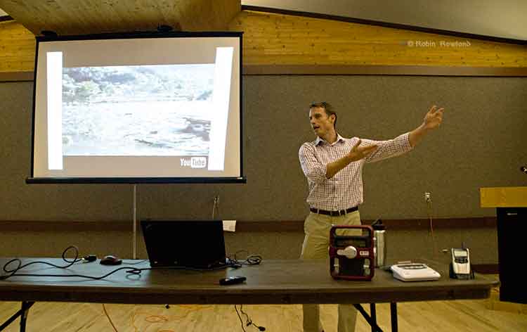
Teron Moore of Emergency Management explains a surge tsunami at a emergency preparedness forum at Riverlodge, Nov. 4, 2013 (Robin Rowland/Northwest Coast Energy News)
The District of Kitimat plans to issue a tsunami hazard and evacuation map for the town.
Fire Chief Trent Bossance and Emergency Coordinator Bob McLeod told a forum on emergency preparedness on November 4 that the map is in the final stages of preparation and will be distributed to residents in the near future.
The forum was also told that the former District Council Chambers on the second floor of the public safety building (the fire hall) is being converted into “a fixed, permanent emergency operations centre,” with upgraded communications and computer equipment.
McLeod said that over the past months, since the October 27, 2012 Haida Gwaii earthquake and the January 31, 2013, Sitka, Alaska earthquake, Kitimat’s emergency planners have been working with the province to update the original emergency plan which was first developed about 12 years ago.
McLeod said that the plan was recently sent to a consultant who told Kitimat the overall plan only needed minor charges. Now, however, there is new emphasis on tsunami planning.
Fire Chief Bossance says emergency planners have been consulting with scientists who have concluded that if a tsunami was to come into Kitimat from Douglas Channel, it most likely would be between two and four metres, so to be on the safe side, the District is planning on a “six metre baseline” from the high tide line. That means the hazard map will be based on the possibility of a six metre tsunami coming up the Channel. ( A worst case scenario, however, could result in a bigger tsunami, perhaps eight metres).
The forum at Riverlodge was part of an effort by both federal and provincial officials to visit communities that were affected by the two recent major earthquakes, inform local residents of updated planning by the federal government and British Columbia and to let those officials know what local concerns are.
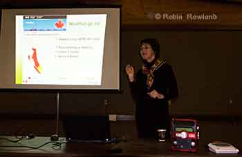
Anne McCarthy of Environment Canada explains that tsunami warnings on the Environment Canada website will be similar to weather warnings. Weather radios can be seen on the table in the foreground. (Robin Rowland/Northwest Coast Energy News)
Anne McCarthy of Environment Canada says her agency is planning to expand the Weather Radio system, most popular in Tornado Alley in the United States, to the northwest coast. There are already Weather Radio transmitters in the Lower Mainland. Kitimat, however, at this point, is low on the priority list, with Prince Rupert and then Sandspit and Masset roll outs in the coming year.
Environment Canada also plans to implement a Twitter feed sometime in 2014, that would supplement other Twitter feeds from Emergency Planning BC and the recently renamed US National Tsunami Warning Center (formerly the Alaska and West Coast Tsunami Warning Center), operated by the US National Oceanic and Atmospheric Administration. Tsunami warnings will also be posted on the Environment Canada website in the same way weather and other alerts are posted.
Surge of water
If an earthquake-triggered tsunami was to strike Kitimat from Douglas Channel, it would not be the big waves seen in the movies and during the 2004 Southeast Asia tsunamis, Teron Moore, a seismic specialist with the BC Provincial Emergency Management said. Given the configuration of Douglas Channel and its many islands, a tsunami is more likely to be a “surge” of water.
“Tsunamis can appear like a rising tide that quickly keeps coming in, “ Moore said. “A normal tide would stop at the high tide line.Sometimes a tsunami can be a quickly rising tide that keeps on coming….A wave can come in for 30 minutes. it’s a long, long time that these waves just keep on coming in and you wouldn’t see the crest of a wave, necessarily and then they come out. So it’s almost like that river comes in for half an hour and then can go back out for half an hour. There’s a tendency for people first of all to not think it’s dangerous, A second, third and fourth wave can come in.”
Tsunami events can last as much as eight to twelve hours, Moore said. Depending on the location of the triggering earthquake, Kitimat is likely to have some warning of a possible incoming earthquake-triggered tsunami.
The second type of tsunami could be triggered by a submarine landslide in Douglas Channel, as happened with slope failures in October 17, 1974 (triggering a 2.4 metre tsunami at low tide) and on April 27, 1975 (generating an 8.2 metre tsunami). The 1975 tsunami destroyed the Northland Navigation dock near Kitimat and damaged the Haisla First Nation docks at Kitamaat Village.
“The slide in 1975 generated an eight metre wave that came from Moon Bay across to Kitimat Village, now that is huge wave. We can’t really predict an event like that, it would happen so fast,” McLeod said.
Hazard areas
Two major fault lines could trigger shaking in Kitimat and might possibly also mean that there could be a tsunami.
The first is the Cascadia fault which goes from the northern California to the western edge of Vancouver Island. The second is the Queen Charlotte fault off Haida Gwaii.
The Cascadia fault, Moore said, is an active subduction zone. “A subduction zone is where two of earth’s large plates are colliding against each other and one of those plates is going under neath another one of those plates.’ The plates get stuck and build up strain “almost like pulling an elastic band. At sometime the elastic band snaps creating a very large earthquake,” Moore said.
The Juan de Fuca plate is a very large plate subducting underneath the continent of North American plate. The Juan de Fuca plate has been stuck for some 300 hundred years since the last time it ruptured. There is a rupture about every 500 years or so in this zone that triggers a large earthquake.
“But, Moore warned, “it’s 500 years plus or minus 200 years. even though there’s a lot of modelling doing on, there’s still a lot of uncertainty and so its a concept that it is difficult to get an understanding of.
“The Haida Gwaii or Queen Charlotte fault….is one that is going side by side. It’s called a strike slip fault. “A strike slip fault can still cause earthquakes it can still rupture and cause shaking, but if it doesn’t have that subduction, you tend to not have tsunamis. “Although science says the Charlotte fault has a low likely of causing a tsunami, but as we know from last year the Charlotte fault did cause a tsunami, quite a significant tsunami in some areas, not one that impacted Kitimat but one that could have impacted Kitimat and did impact, the west coast of Haida Gwaii quite significantly.
“We were very lucky there weren’t any large communities out there. We very lucky that it wasn’t at the height of summer tourist season with kayakers and fishing lodges. In some areas, the way the wave came into certain bays, created a five metre tsunami. “So if you were on the beach and a five metre tsunami was coming up the inlet, that’s a significant tsunami. What I want to emphasize is that people here who felt the shaking, they should have gone to high ground.”
Emergency procedures
In the case of a major earthquake, where residents of Kitimat feel shaking, then they should take appropriate precautions, the forum was told, including moving to higher ground if they think they should.
“Once the maps are available we will get them out to the public. I think it is important for the public to understand and visualize, where they sit within that six metre height. Always if you’re unsure go to higher ground. It’s easier to come back if your house is unaffected, than trying to leave if your house is being affected,” McLeod said.
There would be no reason to actually leave Kitimat, according to Emergency Management B.C.’s northwest regional manager Maurie Hurst. “Kitamaat Village should evacuate to higher ground. I would not like to see them coming down that coast highway to Kitimat, that’s not safe. Stay where you are, move to higher ground.
“At Sandspit higher ground is quite a ways a way from the community for them they are having to a bit of travel but in Kitimat higher ground is a ten minute walk, a five minute drive, it’s right here within the community.”
After an earthquake occurs, the National Tsunami Warning Center in Homer, Alaska evaluates the situation and sends out alerts to Canadian and US government agencies. In British Columbia, Emergency Management BC is the lead agency.
It communicates with Environment Canada, the Canadian Coast Guard, local emergency officials and the media. In Kitimat, it is the local emergency management officials and first responders who are in charge.
After misinformation went out over social media during the October 27, 2012 event, McLeod says the District of Kitimat now has social media specialists at the Emergency Operations Centre. “We’ve modified the district website, so there will be banners going up on it, just to get accurate information out.” Using the baseline of six metres above high tide, McLeod says the Rio Tinto Alcan wharfs, MK Bay Marina and the Kitamaat Village dock would most likely be affected.
While that means most of the Kitimat community may not be affected, there are other factors involved, according to Chief Bossance. “Because of all the islands we have in the waterways, we’re not going to have that big wave, we are going to have that surge,” he said. “If a tsunami is coming, we always look at the earthquake, what was its magnitude, obviously the higher the magnitude, the more impact it’s going to have for everyone in that case.
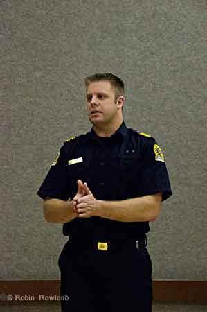
Kitimat Fire Chief Trent Bossance explains emergency procedures in case of a tsunami (Robin Rowland/Northwest Coast Energy News)
“We looked at seven point seven the most recent one, (on Haida Gwaii)it had very little impact here due the fact that it was a slip slide.
“The other fault, the one along Vancouver Island, is a different fault altogether. The problem we’re having with us right now, there haven’t been a lot studies conducted with how that waters going to impact coming from that direction into us.
“If it’s a significant shaking, don’t wait for us to tell you to go high ground.
“So they’re saying anywhere from two metres, depending on high tide up to four. We took the next step and said we’re going to go with six to build in a safety factor.
“But saying that, we have to know what our tide heights are at the time the tsunami strikes. The other thing we look at is the magnitude of the quake.
“So if you’re living down in the Kildala area and if we determine that it’s an eight metre event, then evacuation might be necessary.
“Everything is do dependent on what happens from the time of the earthquake, the tides, the weather. If we’re having significant rainfall at the time, that would mean the river would swell. If it’s the fall when we get our monsoons, that may change the fact of what’s going to happen.
“If you look at the dike, the dike is what is separating us from the river. Kitimat is sort of odd in that we have a dike that surrounds a lot of the town, but there’s an open spot in it, so it’s going to funnel through there and into the lower lying areas of the Kildala area.”
Under most circumstances, Bossance said, the City Centre Lower Parking lot would be above the danger zone.
“Just because we’re looking at six doesn’t mean it’s not going affect everyone, our plan is constantly evolving. Local officials are the ones to tell you it is safe to go back home.”
Boaters concerned
There was one question arose at the forum that the panelists had no immediate answer for. What should boaters do if there is a tsunami warning while they are on the Channel, especially during the summer or the peak salmon season when there could a hundred or so boats on the water?
“Douglas Channel is a deep channel,” Bossance said. “It’s in the shallow water and it builds, but here it is relativey deep water until it’s close to shore. That’s why it’s such a great deep sea port,its deep and then it shallows fairly quickly that’s why they’re saying we’re not going to have that big wave coming in., its going to be a surge of water.”
The panel they would investigate the situation further but at the moment they presume that it would be best to go the center of the channel. “The usually advice to make for open water that’s what the [US] coast guard recommends.”
A similar brochure from Hawaii recommends a minimum depth of 300 feet and staying clear of a harbour entrance channel during an event. The Hawaii brochure warns that if a boater is not on the water, they should not go down to their boats.
The brochure notes that: “In 1964 in Kodiak, Alaska, a warning was received prior to the arrival of the first tsunami waves. People who rushed down to the harbor to secure or take their boats out to sea constituted two thirds of all the fatalities caused by the tsunami at Kodiak City.” There is, so far, no similar brochure issued by the province of BC.
The panel suggested that a sign be posted at MK Bay, outlining safety procedures. Moore said: “The other thing we’re thinking about is there could be wave action for eight to ten to twelve hours maybe. If you need to have eight to ten hours of gas to fight the current, eight to ten hours of food, all the things you’re going to need. There were cases in California where boats kept on idle to keep being driven into shore and then they run out of gas, and then they ended up in dangerous situations. Each individual has to assess how big is their boat and where it is in the water and how it’s going to come in.
“For me I would rather be on shore if I could get to shore quick enough and get to higher ground but if you’re closer to the ocean and you have a big vessel and have the gasoline for 10 hours, then may be you’re better off.”
The Hawaii brochure also warns that watches and warnings for mariners on VHF Channel 16 (the calling and emergency channel) may be different for those on land. Hurst noted that some people in Haida Gwaii were picking up US Coast Guard advisories on VHF 16 which said the October tsunami warning had been downgraded. While the warning was downgraded for Alaska, the warnings continued for Haida Gwaii.
Hurst said those monitoring Channel 16 must be be sure they are monitoring the advisories on 16 from Prince Rupert Coast Guard Radio.
Another problem, given the configuration of Douglas Channel, is that if a tsunami severely damages MK Bay, Minette Bay, the Village Dock, the RTA docks and Nechako dock, there may be no place for boaters to return to safely given the rocky shore of Douglas Channel, which is quite different than coasts of California or Hawaii where boating is part of the emergency planning.
“The Kitimat emergency plan will have to take into consideration boaters on the water, it’s not necessarily covered by legislation but if the plan exists, they can get it out to citizens who are out on the water,” Hurst said
Preparation
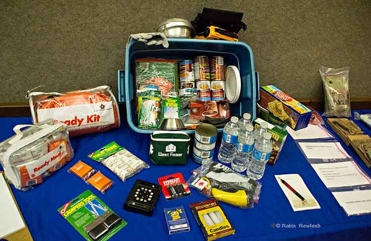
A 72-hour emergency kit was on display at Riverlodge. It includes the civilian version of military meals ready to eat as well as both dried and canned food, water, a first aid kit and other supplies. (Robin Rowland/Northwest Coast Energy News)
“From an earthquake perspective,” McLeod said, “folks should be looking at their own home preparation, making sure your residence is as earthquake proof as you could possibly make it by anchoring things to the wall, by making every effort that things are not going to fall on you. Every October there’s going to be a shakeout, which gives all an opportunity to get under the table and practice, drop, cover and hold on.
“So know the hazards, have a plan, have an emergency kit. You rotate the products in it on say an annual basis, hopefully you never have to touch it, but it’s there if you definitely need it. The emergency kit should have supplies for both humans and pets for a minimum of 72 hours.
Planning should also take in to consideration that even if there isn’t major damage in Kitimat, due emergencies in other parts of the province, the town could be cut off for several days, resulting in shortages.
Supporters of David Black’s Kitimat Clean project to build a refinery about 25 kilometres north of Kitimat have been met by skepticism by experts and economists from the Canadian oil patch who keep telling the people of northwestern British Columbia that to create jobs by adding value to Alberta crude is uneconomic.
The Americans, apparently, have a different view, with plans announced for shipping projects in Washington State that could handle not only oil shale crude from the Bakken Formation in the Dakotas but also Canadian “heavy crude” aimed at refineries in Californa, refineries that would require new or renovated facilities.
So let’s add another question to northwest BC’s skepticism about the Alberta oil patch. Why is uneconomic to refine in Alberta or BC, but apparently increasingly economic to refine in California given the cost of building or rebuilding facilites?
Opponents of the Northern Gateway pipeline have always speculated that any bitumen exported from Kitimat could end up in California rather than markets in Asia.
According to reports, the Vancouver, Washington, project plans to load the bitumen on barges for shipment to California, which is likely to cause a storm of controversy with environmental groups in both states, especially if a barge, which has almost no controls compared to a tanker, foundered and ended up on the coast. [adsanity id=5199 align=alignright /]
The New York Times, on Oct. 31, looked at the issue in a report Looking for a Way Around Keystone XL, Canadian Oil Hits the Rails. The issue of moving crude by rail has been gaining traction in recent months, with growing opposition to pipeline projects. But where do those long trains of tank cars full of crude go?
Times reporter Clifford Kraus says:
The developing rail links for oil sands range across Canada and over the border from the Gulf Coast to Washington and California. Railways can potentially give Canadian producers a major outlet to oil-hungry China, including from refineries in Washington and California.
According to the Times, the plans call for two Canadian export terminals.
“We want to diversify our markets beyond just moving our product south,” said Peter Symons, a spokesman for Statoil, a Norwegian oil giant that has signed contracts to lease two Canadian oil loading terminals. “We can get that product on a ship and get it to premium markets in Asia.”
The Americans, on the other hand, are looking toward refineries.
Again the Times report says:
Several Washington and Oregon refiners and ports are planning or building rail projects for Canadian heavy crude as well as light oil from North Dakota. The Texas refinery giant Tesoro and the oil services company Savage have announced a joint venture to build a $100 million, 42-acre oil-handling plant in the Port of Vancouver on the Columbia River that could handle 380,000 barrels of oil each day if permits are granted.
Not that everything is clear sailing. The Times says there is resistance to a plan to refine heavy crude in California.
The city of Benicia, Calif., last month delayed the granting of a permit for Valero Energy’s planned rail terminal at its refinery by deciding to require an environmental impact report after residents expressed concerns that Valero would use the terminal to import Canadian oil sands crude.
With access to rail and existing marine infrastructure, the Port of Vancouver is uniquely positioned to serve as a hub for the distribution of North American crude oil to West Coast refining centers. Tesoro and Savage are ideal partners for this project, having already operated in close partnership for almost ten years on the West Coast. The Tesoro-Savage Joint Venture’s combined capabilities, experience and resources are expected to create substantial benefits for the Port and the Vancouver community in the form of sustainable revenue to the Port and local jobs associated with the facility’s construction and operation.
The Tesoro news release quotes Greg Goff, President and CEO of Tesoro.
Building upon the recent success of the rail unloading facility at our Anacortes, Wash., refinery, where we have been delivering Mid-Continent crude oil via unit train in an environmentally sound and cost-effective manner, this project is the ideal next step for Tesoro as we drive additional feedstock cost advantage to the remaining refineries in our West Coast system.
While the Tesoro April release doesn’t specifically mention heavy crude or bitumen from Alberta, in August, Reuters reporting on a Tesoro results conference call said, the project would “supply cheaper U.S. and Canadian crude to refineries all along the West Coast – both its own and those run by competitors.”
The project, which would initially have capacity of 120,000 barrels a day and could be expanded to 280,000 BPD, is the biggest so far proposed to help Pacific Coast refineries tap growing output of inland U.S. and Canadian heavy crudes.
The project, where North Dakota Bakken and Canadian crude would travel by rail to the marine facility in Vancouver, Washington and then barged to refining centers, is being planned with joint venture partner Savage Companies.
The Port of Vancouver facility will have “a lot of flexibility and capability to take different types of crudes, from heavy Canadian crudes to crudes from the Mid-Continent… So we will source crude from where the best place is,” Goff said on Aug. 2. “The facility also was designed to supply the entire West Coast… We can go from as far away as Alaska to Southern California, in those refineries, which we intend to do.”
Reuters also reported
Regulators also are considering Valero’s permit request for a 60,000 bpd rail facility at its 78,000 bpd Wilmington refinery near Los Angeles, but in June the area pollution regulator said it would take 18 months to finish an environmental review, permitting and construction.
Alon Energy USA also is seeking permits for a rail facility at its Southern California refining system, which shut down late last year as losses mounted on high imported crude costs and low asphalt demand. The company hopes to get those permits by year-end.
Valero spokesman Bill Day on Friday declined to say whether Valero would be interested in tapping inland and Canadian crude through the Tesoro project, but noted that the company values flexibility in getting cheaper crudes to its refineries.
Asked today about the New York Times report, (at the time of his regular news conference, he hadn’t read the story) Skeena Bulkley Valley MP Nathan Cullen said, “I mean there’s been so much uncertainty, in large part created by this government with respect to moving oil anywhere. This is another proposal, it seems every week you wake up, open the papers and there’s another proposal. Some of them are legitimate, some of them are snake oil.
“This one I’m not familiar with, so I can’t make specific comments on it, I will certainly look at it because I’m very interested in energy on the west coast. I’d have to see, given the government we have in Ottawa right now, they’re not friends to communities and First Nations and certainly not friends to the oil sector because they keep causing so much concern within the broader public and hurt the companies’ ability to gain social licence to get a project going.”
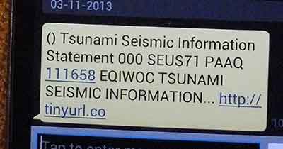
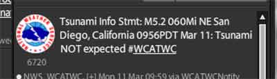
For the past month, text message tsunami warnings from the West Coast and Alaska Tsunami Warning Center have transformed from clear, concise vital information to incomprehensible computer code with a link to a useless URL–at least on my Bell Android Samsung phone.
Take the warning for this morning’s 4.7 magnitude earthquake which shook southern California. The Los Angeles Times is now reporting there have been more than 100 aftershocks from the quake.
My phone beeped this morning with the tone that let me know that this was a possible tsunami warning.
This is what appeared on my phone.
This is what appeared on my Tweetdeck feed.
The SMS text message is completely useless. Not only is there no vital information, it directs you to tinyurl.co, which (if the URL is not truncated) usually reaches the homepage for the Tiny URL website. On other times clicking on a link goes to a spam like, buy this domain site, tinyurl.co which is even worse.
I began subscribing to the WCATWC warning messages on my phone the day after the October 27, 2012 earthquake on Haida Gwaii.
From October until mid-February, the messages on Twitter and on my phone were identical. Then in February everything changed, perhaps because NOAA, the US National Oceanic and Atmospheric Administration, changed the transmission servers. Although it is not clear why simply changing a the outgoing server would have any affect on a message that the US and Canadian federal governments and the state and provincial governments along the west coast consider vital public information.
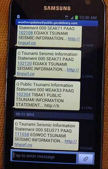
Here are the latest messages as they appeared on my phone.
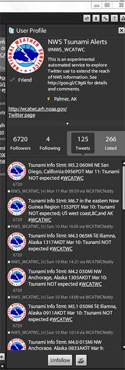
Here is how the same warnings appeared on Tweetdeck.
According to my phone’s text message log, the last clear message about a possible tsunami was received on February 14 from the server nws.noaa@service.govdelivery.com. All the gobbledygook messages since then have come from weatherupdates@public.govdelivery.com.
Here is how the tsunami warnings appeared on my phone prior to the server change on Feb. 14.
A spokesperson for the tsunami warning center could not be reached for comment.
Related issue: The death of Tweetdeck
A somewhat related issue to the failure of the SMS messages from the tsunami warning center is Twitter’s (in my view completely stupid) decision last week to kill Tweetdeck for the Android and Apple phones.
I have always followed earthquake and tsunami warnings (as well as other breaking news stories) using Tweetdeck for both my desktop and my phone.
For the past month, as soon as I’ve heard the tsunami alert on my phone, I have gone straight to Tweetdeck, ignoring the bad text message.
Twitter which bought Tweetdeck last year, now wants to force users to their own mobile apps and to use the Chrome version on the desktop.
Frankly, the Twitter app for the Android was and is awful which is why I kept using Tweetdeck and will do so until Tweetdeck is killed by Twitter. I do use the Twitter app for my iPad and I don’t like it either. Unlike Tweetdeck, neither app has the flexibility that I require as a journalist. With Tweetdeck, even on a phone, you can call up specific topics quickly and switch back and forth.
Twitter says
discontinuing our app support is a reflection of where our TweetDeck power-users are going. Over the past few years, we’ve seen a steady trend towards people using TweetDeck on their computers and Twitter on their mobile devices.
I have to wonder what kind of power users Twitter is referring to. Many journalists (and activists and politicians) reacted to the decision with horror.
There is speculation that Twitter, which has to make money, of course, wants to drive users to its own apps so it can load advertising on the feed. That’s a legitimate business decision.
For years, Tweetdeck has been the go to software for tracking emergencies and breaking news. One has to wonder if any of the California-based employees of Twitter got the same garbled text message that I got and where they went to get better information.
The real test of Twitter’s programs will not how much they are used for gossip, but how they work in an emergency or a disaster.
When I was a kid in Kitimat, for the sake of this argument let’s say it was 1960 and I was ten, my friends were all abuzz.
“John Wayne is in town,” says one friend.
“No way,” says a second.
“Yes,” says a third. “My Dad says John Wayne came in a couple of days ago and went down the Channel to fish.”
John Wayne at the helm of his boat The Wild Goose, now a US National Historic Landmark
None of my friends ever confirmed that “the Duke” had come into town. The adults did say that “everyone knew” that John Wayne had come up from Vancouver Island, gone to Kitamaat Village, hired a Haisla guide and then had gone fishing on Douglas Channel.
John Wayne’s fishing trips were famous. He was Hollywood’s most avid fisherman. He was a frequent visitor to the British Columbia coast throughout his life. (He also fished in other areas such as Acapulco.)
There’s a secret economy in northern British Columbia. The movie star economy. For more than a century the rich and famous have been coming to northern BC to fish and to hunt and to hike. Sometimes the stars and the millionaires are open about their stay. More often they slip in and no one is the wiser.
One of the lodges along the coast that caters to those members of the one per cent who like to fish, hunt, kayak or hike is Painter’s Lodge in Campbell River. On its website, Painter’s Lodge proudly numbers among its previous guests John Wayne, Bob Hope, Bing Crosby, Susan Hayward, Julie Andrews and Goldie Hawn.
The King Pacific floating lodge also has movie stars among its guests each summer, and CEOs and billionaires, not just from the United States but around the world. King Pacific is well known for its tight confidentiality policy to protect the identity and privacy of its guests.
They slip in to the north incognito. Perhaps they drive up Highway 16.
These days if a movie star’s private jet lands at Terrace Kitimat International Airport, that jet would be unnoticed among all the other private jets coming and going with energy executive passengers.
A guide’s van waits close to the landing area, the star walks, unnoticed, from the plane to the van, and disappears into a small, but comfortable, lodge somewhere in the bush. A float plane lands at a secluded cove or near a river estuary. The man who gets out, unshaven, in jeans and a checked shirt could be an Oscar winner or one of the world’s successful entrepreneurs or even one of the exploitative Wall Street one per cent. Perhaps even a top of executive of a major energy company.
The guide will never tell. That’s part of the business.
So as Prime Minister Stephen Harper, contemptuously told Peter Mansbridge, when asked about the Northern Gateway pipeline: “Just because certain people in the United States would like to see Canada be one giant national park for the northern half of North America, I don’t think that’s part of what our review process is all about.”
Harper also said: “It’s one thing in terms of whether Canadians, you know, want jobs, to what degree Canadians want environmental protection.”
The prime minster, with his masters degree in economics obviously doesn’t get it. What’s wrong with a national park that supports thousands of jobs?
So let’s add up the jobs.
Enbridge’s official estimates say Kitimat will get between 30 to 40 permanent jobs from the bitumen terminal. (Other documents filed with the Joint Review say 104 permanent jobs). At the moment, Cenovus imports condensate to Kitimat, processes it at the old Methanex site and ships the condensate by rail to the Alberta bitumen sands. That means, according to local business leaders, that when the current Cenovus jobs are absorbed by the Enbridge project, Kitimat may get as few as 25 net jobs.
The jobs along the pipeline route, at least from Prince George to Kitimat, you can probably count on the fingers of one hand.
The temporary construction jobs will be in the northwest for a couple of years and then they’ll be gone.
Now what about the movie star economy? It’s been supporting British Columbia for a century.
Seven luxury lodges belonging to the Oak Bay Marine Group. King Pacific Lodge. Other smaller, luxurious lodges that aren’t as well-known or publicized.
Hundreds of small lodges up and down the BC Coast, along the Skeena River and the Nass. The lodges and resorts at Babine Lake, close to the pipeline route.
Then’s there’s the tackle shops, ranging from mom and pop operations to all those Canadian Tire stores in the northwest.
Guides and outfitters. Campsites. Gas stations (yes people up here drive using gasoline). Restaurants.
For conservatives, the pipeline debates are now a litmus test of ideological purity. Facts don’t matter.
Take for example, Margaret Wente in today’s Globe and Mail when she says: “These environmentalists don’t really care about safety matters such as oil leaks or possible pollution of the aquifers.”
Or Peter Foster in the Financial Post, who says: “Promoters of oil and gas development are in the business of creating jobs; radical environmentalists are in the business of destroying them.”
That latter statement is the now consistent refrain among the idealogues, the answer for them to why Chinese and American energy money is acceptable but money from American or other environmental foundations isn’t acceptable. And it’s false.
An oil spill, whether from a tanker or a pipeline breach would destroy thousands of jobs in northwestern British Columbia. For Wente to say that environmentalists don’t care about oil spills, simply shows she is so narrow minded that she doesn’t read the news pages of her own newspaper, much less doing some real reporting and reading the transcripts of the Joint Review Hearings where up until now all the testimony has been about safety matters and oil leaks.
So who produces more jobs in northwestern British Columbia? Movie stars? The Alberta oil patch?
Answer: the environment, the fish and the wilderness create the jobs.
The movie star economy creates the jobs.
So movie stars. Come on up. Your secret is safe with us. Enjoy the fishing.
(And I’ll bet that if John Wayne, American conservative, and life long fisherman, were alive today, he’d be standing beside Robert Redford and the other stars who are opposing the Northern Gateway pipeline).


