Ninety-seven years ago, long before the main townsite was founded in the 1950s, (the Haisla Nation, of course, had been here for thousands of years) Kitimat was to play a short, now forgotten and unlucky role in the First World War with the launch of a vessel in New Westminster called the War Kitimat as one of the many emergency new ships commissioned by the British government to replace vessels lost to Germany’s unrestricted submarine warfare that was sinking convoys taking vital supplies across the Atlantic.
During the First World War, over nine million gross tons of British ships were lost due to enemy action, both submarines and surface raiders. The worst losses came in the three months ending June 1917 when over 1.4 million gross tons were sunk.
In December, 1916, the Prime Minister David Lloyd George’s British Government appointed a “shipping controller” to manage a worldwide shipbuilding program to replace the lost vessels, to be built quickly, efficiently and to a series of standard designs. Although the vessels were often different, they were called “standard ships.” It was the Great War’s equivalent of the Liberty Ships built during the Second World War.
Many of the orders were placed with Canadian companies, others with the Japanese shipyards and British owned or controlled shipyards in Hong Kong and Shanghai. Canada created or contracted 19 emergency shipbuilders which built 137 cargo ships and 15 trawler/minesweepers. Some of these yards were purpose-built, others were repair yards that were converted to construction yards; seven were in BC, nine were in Ontario and Quebec, and three were in the Maritimes.
Orders were also placed with shipyards in the United States, but when the Americans entered the war in 1917, those ships were requisitioned by the U.S. Government.
All the ships’ names were given the prefix “War” no matter where they were built in the world.
The Canadians built both steel hulled and wooden hulled cargo vessels, including the War Kitimat, as well as yachts and sailing yachts (which likely became the war time “trawlers”). The British built 12 different types of “dry cargo” vessels, five types of “coasters” plus tankers. The United States also built wooden hulled cargo vessels (slightly larger than the Canadian versions) and various types of steel hull cargo ships.
The government of France also contracted Canadian shipyards for its own vessel building program.
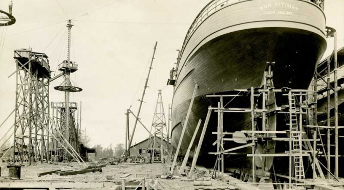
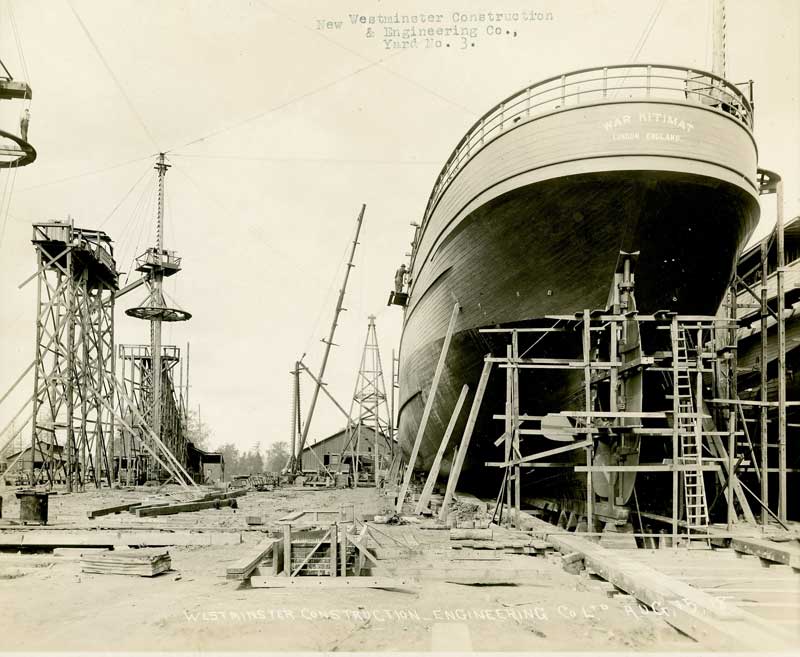
In Canada, the BC Marine Railway Company was one of the prime contractors, and the job of building four ships was awarded to the New Westminster Shipbuilding & Engineering on Poplar Island, which can be seen today from New West’s Esplanade at Westminster Quay.
The First Nations of the area had used the island for generations and in 1871 the island was designated an Indian Reserve. During the small pox epidemic of 1889, with many members of the Vancouver area First Nations struck down by the disease, a hospital was built on the island. It is believed that many of those who died of smallpox were buried there. Because of the association with disease and death the island was abandoned until 1917, when the war time necessity meant a shipyard was built on the island.
New Westminster Shipbuilding had the job of constructing four “war” class wooden hulled freighters, 2300 gross tonnes, 3300 dead weight tonnes, 250 feet long with a beam of 43.5 feet, with 322 nominal horse power triple reciprocating steam engines powered by two water tube boilers, turning a single screw capable of ten knots.
The company built four ships, the War Comox, War Edensaw, War Kitimat and War Ewen. The War Comox was first launched in April, 1918, but completion was held up as the shipyard waited for equipment from suppliers. That led to pressure to build, launch and complete the War Edensaw, which was launched in June 1918, and the War Kitimat, which was launched on Sunday, August 18, 1918.
The War Kitimat immediately ran into trouble. According to the Times Colonist, right after launch the War Kitimat ran aground off New Westminster and had to be lifted off the Fraser river bed by using jacks until was raised enough so that tugs could attach lines and tow it to deep water. About a week later, the War Kitimat was towed to Victoria for repairs and further fitting out (possibly to the Foundation Company shipyard which was also building five of the war class vessels. Foundation is now Seaspan’s Point Hope Marine)
The War Kitimat did make at least one voyage to Great Britain, but by the time it arrived, the war was coming to a close. After the Armistice on November 11, 1918, the ships were no longer needed and the British government sold most of them to shipping companies. (All the ships were UK registry, not Canadian)
Flag for Lloyd RoyalBelge line
In 1919, the War Kitimat was sold to the Lloyd Royal Belge S.A. line of Antwerp, Belgium and renamed the Serbier.
On January 12, 1920, the Serbier, on a voyage from Cartagena and Oran to Antwerp with zinc ore and general cargo on board, sprang a leak in her engine room during a “raging gale” in the Bay of Biscay and sank 80 nautical miles (150 km) off Penmarc’h, Finistère, France at 47°38′N 6°10′W. Her Capt. A. Canfrère and the crew were rescued by the French ship SS Docteur Pierre Benoit.
How the ship came to be named War Kitimat isn’t certain. It was probably named after the Kitimat River since other vessels in the War category were named Skeena, Stikine, Babine, Niagara, Ottawa (others were named for cities like Halifax or Toronto).
The Belgian shipping company did not give up on the name Serbier. It purchased another US-built War cargo ship, first named the War Hound by the British. After the US entered WWI in 1917 and took over the building there it became the Lake Huron, a US Navy Transportation Service mine carrier. From later in 1920, Royal Belge operated the new Serbier until 1924, when it passed through French, Norwegian, Danish and then as the Advance, Finnish ownership. The Advance was seized in Panama by the United States in 1941 and renamed the Trojan. After the Second World War, the US returned the ship to Finland. It sailed as the Advance until it was sold a Greek shipping company in 1965 and scrapped at Piraeus in 1966.
Of the ships under British control, 821 ships were ordered by the UK shipping board and 416 were completed. Fourteen were lost to enemy action. The remaining orders were cancelled but often completed by the shipyards.
Many of the “war” or “standard” ships passed through various owners.
During the Second World War many played their original role and took part in the convoys that crossed the Atlantic. Many were sunk during those crossings. Others, sold to growing Japanese shipping interests in the 1920s and 1930s, were sunk by US destroyers and submarines. Others like the War Hound /Serbier survived to the 1950s and 1960s.
Of the War Kitimat’s sister ships built in New Westminster, the War Comox was sold to an Italian company, renamed the Guidatta and scrapped at Genoa in 1925, The War Ewen was sold to a German company, renamed the Etienne Marcel and scrapped in Germany in 1925. The War Edensaw, under the original name, was carrying Admiralty stores from Constantinople to Malta, when it caught fire on June 25, 1919 and sank 94 nautical miles east of the St. Elmo Lighthouse on Malta.
As for Poplar Island, it was zoned for industrial use but no one could come up with ideas for how to use the island. New Westminster sold the island to Rayonier Canada in 1945, where it became an anchorage for log booms on the Fraser River. The successor company, Western Forest Products sold it back to New Westminster in 1995, The island is still a wilderness area in the middle of urban Vancouver and subject to treaty and land claims negotiations with the area’s First Nations.
The Ship’s List (database of ships, link is to Lloyd Royal Belege entry)
Editor’s Note: Up until now Kitimat has not had a reason, unlike other communities, to mark Canada’s role in the First World War. We suggest that should the District of Kitimat choose to do so either this year or in the next three years, August 18, the date of the launch of the War Kitimat might be an appropriate date, in addition to Remembrance Day on November 11.
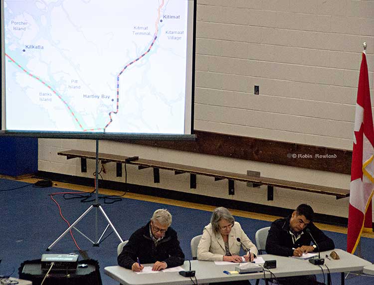
Members of the Northern Gateway Joint Review Panel, left to right, Kenneth Bateman, chair Sheila Leggett and Hans Matthews make notes at the June 25, 2012 hearings at the Haisla Recreation Centre, Kitamaat Village. A map of Douglas Channel can be seen behind the panel. (Robin Rowland/Northwest Coast Energy News)
The Haisla Nation in their response to the Crown on the Northern Gateway Joint Review Panel details four studies, three Canadian and one American that were released after the Joint Review evidentiary deadline had passed, evidence that the Haisla say should be considered in any consideration of the Northern Gateway pipeline, terminal and tanker project. (The American report from the National Oceanic And Atmospheric Administration was released after the JRP final report)
JRP chair Sheila Leggett’s constant citing of rules of procedure and her stubborn refusal to consider new evidence and studies in a dynamic situation that was changing rapidly was one of the reasons that many people in the northwest said the JRP had lost credibility.
The Haisla say: “It is incumbent upon Canada to consider and discuss the information in these reports as part of a meaningful consultation process…” and then lists “key findings” that have potential impacts on aboriginal rights and title:
The West Coast Spill response for the government of British Columbia which found:
Most oil spilled into the marine environment cannot be cleaned up
There is a disconnect between planning and actual repose capability
Canada’s spill response is “far from world class.”
The Transport Canada Ship Oil Spill Preparedness and Response study:
Douglas Channel will go from low risk to high risk for pills if the project goes ahead
The study recommends preparation for a “true worst case discharge” rather than “the credible worst case discharge” as proposed by Northern Gateway
Canada needed a much more rigorous regulatory regime covering tankers.
The joint federal government technical report on the properties of bitumen from the Canadian Oil Sands:
There are uncertainties on how diluted bitumen would behave in a marine environment.
Northern Gateway did not provide adequate information about sediment levels to allow for proper study of interaction with diluted bitumen
Dispersant may not be effective.
Weathered diluted bitumen would “reach densities at which it will sink freshwater without mechanical or physical assistance.”
The US National Oceanic And Atmospheric Administration report on Transporting Alberta Oil sands:
Diluted bitumen has “significant differences from conventional crudes.’ (The JRP used conventional crude as a benchmark in its findings)
The physical properties of diluted bitumen “fluctuate based on a number of factors.
Pipeline operators may not have detailed information related to products in the pipeline at the time of a spill
There is a lack of experimental data on the weathering behaviour of oil sands product which limits the ability of spill response organizations “to understand and predict the behaviour and fate of oil sands products in freshwater, estuarine and saltwater environments.”
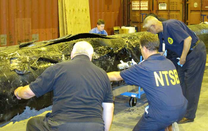
US National Transportation Safety Board staff examine a ruptured pipe from the Enbridge oil spill in August, 2010. The photo was released by the NTSB May 21, 2012. (NTSB)
The costs for Enbridge to clean up the 2010 Marshall, Michigan oil spill now far exceeds the maximum estimate that the Joint Review Panel gave for a major spill on the Northern Gateway Pipeline and also exceeds the amount of money the JRP ordered Enbridge to set aside to deal with a spill. Enbridge’s cleanup costs have also now edged past the higher liability amount requested by the Haisla Nation.
According to the US firm Enbridge Energy Partners’ filing with the United States Securities and Exchange Commission, as of September 30, 2013, the cost of cleanup was $1.035 billion US, not including possible additional fines and penalties that might be imposed by US authorities in the future.
In its decision, the Joint Review Panel estimated the cost a major oil spill from the Northern Gateway project would be about $693 million. As part of the 209 conditions, the JRP ordered Enbridge to set aside “financial assurances” totaling $950 million.
Note all costs in this article are for a pipeline breach. The Joint Review Panel had different estimates for a tanker spill and the liability rules for marine traffic are different from pipelines.
In its filing for the third quarter of 2013, with the SEC, Enbridge Energy Partners say that the cost up until September 2013 had “exceed[ed] the limits of our insurance coverage.” The same filing says that Enbridge is in a legal dispute with one its insurers.
Lakehead Line 6B Crude Oil Release
We continue to perform necessary remediation, restoration and monitoring of the areas affected by the Line 6B crude oil release. All the initiatives we are undertaking in the monitoring and restoration phase are intended to restore the crude oil release area to the satisfaction of the appropriate regulatory authorities.
As of September 30, 2013, our total cost estimate for the Line 6B crude oil release is $1,035.0 million, which is an increase of $215.0 million as compared to December 31, 2012. This total estimate is before insurance recoveries and excluding additional fines and penalties which may be imposed by federal, state and local governmental agencies, other than the Pipeline and Hazardous Materials Safety Administration, or PHMSA, civil penalty of $3.7 million, we paid during the third quarter of 2012. On March 14, 2013, we received an order from the EPA, or the Environmental Protection Agency, which we refer to as the Order, that defined the scope which requires additional containment and active recovery of submerged oil relating to the Line 6B crude oil release. We submitted our initial proposed work plan required by the EPA on April 4, 2013, and we resubmitted the workplan on April 23, 2013. The EPA approved the Submerged Oil Recovery and Assessment workplan, or SORA, with modifications on May 8, 2013. We incorporated the modification and submitted an approved SORA on May 13, 2013. The Order states that the work must be completed by December 31, 2013.
The $175.0 million increase in the total cost estimate during the three month period ending March 31, 2013, was attributable to additional work required by the Order. The $40.0 million increase during the three month period ending June 30, 2013 was attributable to further refinement and definition of the additional dredging scope per the Order and associated environmental, permitting, waste removal and other related costs. The actual costs incurred may differ from the foregoing estimate as we complete the work plan with the EPA related to the Order and work with other regulatory agencies to assure that our work plan complies with their requirements. Any such incremental costs will not be recovered under our insurance policies as our costs for the incident at September 30, 2013 exceeded the limits of our insurance coverage.
According to the SEC filing, the breakdown of costs include $2.6 million paid to owners of homes adversely impacted by the spill.
Despite the efforts we have made to ensure the reasonableness of our estimates, changes to the recorded amounts associated with this release are possible as more reliable information becomes available. We continue to have the potential of incurring additional costs in connection with this crude oil release due to variations in any or all of the categories described above, including modified or revised requirements from regulatory agencies in addition to fines and penalties as well as expenditures associated with litigation and settlement of claims.
The material components underlying our total estimated loss for the cleanup, remediation and restoration associated with the Line 6B crude oil release include the following: (in millions)
Response Personnel & Equipment $454
Environmental Consultants $193
Professional, regulatory and other $388
Total $ 1,035
For the nine month periods ended September 30, 2013 and 2012, we made payments of $62.3 million and $120.9 million, respectively, for costs associated with the Line 6B crude oil release. For the nine month period ended September 30, 2013, we recognized a $2.6 million impairment for homes purchased due to the Line 6B crude oil release which is included in the “Environmental costs, net of recoveries” on our consolidated statements of income. As of September 30, 2013 and December 31, 2012, we had a remaining estimated liability of $265.9 million and $115.8 million, respectively.
As for insurance, Enbridge Energy Partners say:
The claims for the crude oil release for Line 6B are covered by the insurance policy that expired on April 30, 2011, which had an aggregate limit of $650.0 million for pollution liability. Based on our remediation spending through September 30, 2013, we have exceeded the limits of coverage under this insurance policy. During the third quarter 2013, we received $42.0 million of insurance recoveries for a claim we filed in connection with the Line 6B crude oil release and recognized as a reduction to environmental cost in the second quarter of 2013. We recognized $170.0 million of insurance recoveries as reductions to “Environmental costs, net of recoveries” in our consolidated statements of income for the three and nine month periods ended September 30, 2012 for the Line 6B crude oil release. As of September 30, 2013, we have recorded total insurance recoveries of $547.0 million for the Line 6B crude oil release, out of the $650.0 million aggregate limit. We expect to record receivables for additional amounts we claim for recovery pursuant to our insurance policies during the period that we deem realization of the claim for recovery to be probable.
In March 2013, we and Enbridge filed a lawsuit against the insurers of our remaining $145.0 million coverage, as one particular insurer is disputing our recovery eligibility for costs related to our claim on the Line 6B crude oil release and the other remaining insurers assert that their payment is predicated on the outcome of our recovery with that insurer. We received a partial recovery payment of $42.0 million from the other remaining insurers and have since amended our lawsuit, such that it now includes only one insurer. While we believe that our claims for the remaining $103.0 million are covered under the policy, there can be no assurance that we will prevail in this lawsuit.
The Joint Review, Enbridge and Michigan
The Joint Review Panel based its finding on the Marshall, Michigan spill on the figure of $767 million from the summer of 2012 –again showing the limitations of the JRP’s evidentiary deadlines since the costs are now much higher.
The JRP quoted Enbridge as saying:
Northern Gateway considered the high costs of the Marshall, Michigan spill, which were at least $252,000 per cubic metre ($40,000 per barrel), to be an outlier or a rare event because the spill occurred in a densely populated area, because the pipeline’s response time was abnormally long, and because there was the prospect of potentially lengthy legal proceedings.
Enbridge assured the JRP that the corporate culture and management changes and equipment upgrades since the Marshall, Michigan spill lowered that chances of a similar event.
The company based its models for the JRP on much smaller spills, including one spill at Lake Wabamun, Alberta from a train not a pipeline (Vol. 2 p 357)
Enbridge’s risk assessment did not “generate an estimate of economic losses caused
by a spill.”
The JRP says Northern Gateway relied on its analysis of literature, and spill events experienced by Enbridge and other liquid hydrocarbon carriers in Alberta and British Columbia. After assessing all of this information, Northern Gateway regarded the high costs of a cleanup as “conservative”–meaning the company expects costs to be lower than its estimates in evidence before the JRP.
In Northern Gateway’s view the most costly pipeline spill incident would be a full-bore oil pipeline rupture, with an estimated cost of $200 million, and an extremely low probability of occurrence.
Haisla evidence
In their evidence, the Haisla (and other First Nations and intervenors) were doubtful about Northern Gateway’s assurances. The Haisla asked that Enbridge have a minimum of $1 billion in liability, an amount Enbridge has now exceeded in Michigan.
Haisla Nation estimated the cost of damage to ecosystem services because of a terrestrial oil spill from Northern Gateway’s pipeline would be in the range of $12,000 to $610 million for a 30-year period.
The Haisla’s cost estimates were based on values for environmental goods and services and probabilities of spills that were independent of Northern Gateway’s parameters for estimating oil spill costs. In contrast to Northern Gateway’s estimated spill frequency and costs, the Haisla predicted that spills would occur more often and placed a higher value on damages to environmental goods and services.
Haisla Nation argued that Northern Gateway overestimated its ability to detect and respond to a spill. In the Haisla’s view this resulted in the cost of a spill and the requisite financial assurances being understated. Haisla cited several factors, including: remote location, limited access, challenging terrain, seasonal conditions, and river flow conditions that would cause the cost of cleaning up a spill in the Kitimat River valley to be significantly greater than the costs associated with Enbridge’s Marshall, Michigan spill.
For these reasons, Haisla proposed that Northern Gateway should be required to obtain a minimum of $1 billion of liability coverage through insurance and financial assurances. Haisla said that Northern Gateway should file annually the report from an independent third party assessing the financial assurances plan. (Vol 2 p359)
In response Northern Gateway said:
Northern Gateway said that Haisla’s findings were based on a number of fundamental methodological flaws and a lack of probability analysis to support the high frequency of occurrence of oil spill events. Northern Gateway argued that Haisla’s estimates of ecosystem service values were inflated because they were based on values from unrelated studies. In Northern Gateway’s view, Haisla relied on high passive use values that were not justified.
JRP ruling
As it has in most of its decision, the JRP accepted Northern Gateway’s evidence, including its explanation of the Marshall, Michigan spill and then went on to base its spill cost estimates not on a pipeline breach but on the 2005 railway spill at Lake Wabumum, near White Sands, Alberta.
The Panel accepts that the cleanup costs for the Marshall, Michigan spill were orders of magnitude higher because of the extended response time. In this application, the Panel accepts Northern Gateway’s commitment to complete the shutdown in no more than 13 minutes after detection. For this reason the Panel did not use the Marshall spill costs in its calculations. The spill volume and the resulting costs are directly dependent on the Northern Gateway’s control room staff and the pipeline control system fully closing the adjacent block valves no longer than 13 minutes from the detection of an alarm event, as well as the amount of oil which would drain out of the pipeline after valve closure due to elevation differences.
The Panel decided on a total unit cost of $138,376 per cubic metre ($22,000 per barrel). This is midway between the unit cost of $88,058 per cubic metre ($14,000) per barrel proposed by Northern Gateway and the unit cost of $188,694 per cubic metre ($30,000 per barrel) for the Lake Wabamun spill. It is about one-half of the Marshall spill’s unit cost. Giving weight to the Lake Wabamun costs recognizes actual costs experienced in a Canadian spill and the greater costs of spills in high consequence areas. In these areas, individuals, populations, property, and the environment would have a high sensitivity to hydrocarbon spills. The deleterious effects of the spill would increase with the spill volume, the extent of the spill, and the difficulty in accessing the spill area for cleanup and remediation.
Using these spill volume and unit cost values in the calculation below, the Panel estimated the total cost of a large spill could be $700 million. Total cost of a spill = 31,500 barrels x $22,000 per barrel = $693 million, or $700 million when rounded up.
(p362)
The Panel based the financial assurances requirements for Northern Gateway on a spill with a total estimated cost of $700 million and directs Northern Gateway to develop a financial assurances plan with a total coverage of $950 million that would include the following components:
i. Ready cash of $100 million to cover the initial costs of a spill;
ii. Core coverage of $600 million that is made up of stand-alone, third party liability insurance and other appropriate financial assurance instruments, and
iii. Financial backstopping via parental, other third party guarantees, or no fault insurance of at least $250 million to cover costs that exceed the payout of components i. and ii.
The financial backstopping would be available to fill the gap if the spill volumes or unit costs were under-estimated or if the payout from the core coverage would be less than 100 per cent.
The Panel noted that:
The evidence indicates that there is some probability that a large oil spill may occur at some time over the life of the project. In these circumstances the Panel must take a careful and precautionary approach because of the high consequences of a large spill. The Panel has decided that Northern Gateway must arrange and maintain sufficient financial assurances to cover potential risks and liabilities related to large oil spills during the operating life of the project.
Northern Gateway committed to investing $500 million in additional facilities and mitigation measures such as thicker wall pipe, more block valves, more in-line inspections, and complementary leak detection systems. This initiative should enhance the safety and reliability of the system and help reduce and mitigate the effects of a spill, but it would not eliminate the risk or costs of spills. This initiative is not a direct substitute for third party liability insurance and does not eliminate the need for liability insurance or any other form of financial assurance to cover the cost of a spill. (p 361)
So the JRP decision comes down to this, if you accept Northern Gateway’s position that pipeline spills are rare and mostly small, then the company has the financial resources to cover the damage. If, however, Northern Gateway is wrong and the costs of a pipeline cleanup exceed the $950 million required by the Joint Review Panel, as has happened in Michigan, then those JRP conditions are already obsolete.
(Northwest Coast Energy News encourages all readers to read the complete JRP report and SEC filing since space and readability does not permit fully quoting from the report)
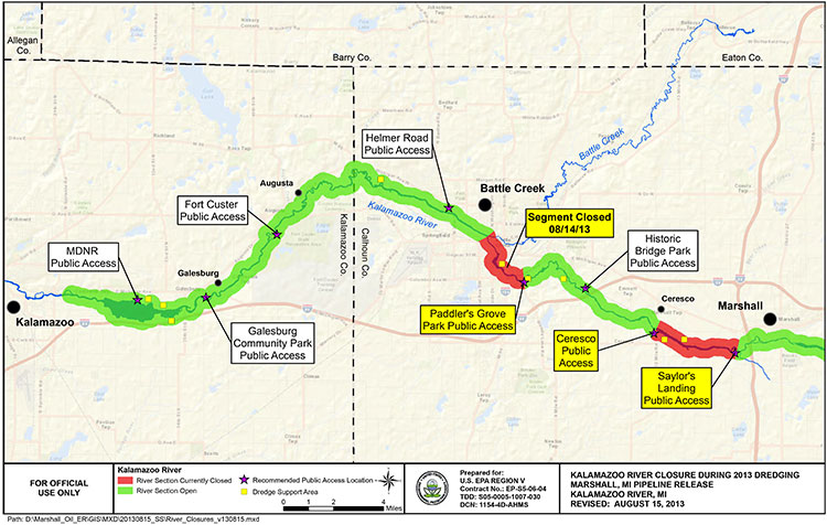
EPA map of river closures and dredging operations on the Kalamazoo River during 2013. (EPA)
Enbridge has missed the US Environmental Protection Agency’s deadline to clean up parts of the Marshall, Michigan bitumen spill by December 31, 2013.
Local television news, WOOD-TV says the EPA is now considering “enforcement options.”
The EPA had already granted Enbridge a 10 month extension that the company requested in March, 2013, setting the new December deadline.
In November, Enbridge requested a second extension. The EPA denied that request.
From the EPA letter it appears that, as in previous years, Enbridge is trying to avoid continuing clean up work into the winter. The EPA rejects that position, telling Enbridge it shouldn’t wait until the spring run off could spread the sunken bitumen.
The EPA says that beginning in March, 2013, “Enbridge has successfully removed oil and sediment from two of the three major impoundment areas identified in the order and from several smaller sediment trap locations.”
The letter to Enbridge, from Jeffrey Kimble, Federal On-Scene Coordinator denying the extension is another scathing indictment of Enbridge’s attitude toward the public and the cleanup, citing Enbridge failing to prepare “adequate contingency plans,” by failing to recognize the “serious opposition” the dredging plans.
Although the EPA had told Enbridge to consider alternative plans—and Enbridge claimed it did that—the EPA found the Enbridge’s own logs showed the company didn’t start considering alternatives until it was obvious that Comstock Township would reject their dredging plans.
The EPA letter also reveals that once again Enbridge is reluctant to do further cleanup work during the Michigan winter. The EPA rejects that stance, saying that “Removal of oiled sediments prior to the spring thaw will lessen the potential oiled sediment transport in the spring to Morrow Lake via increased river velocities from rain and ice melt.”
Although we recognize that the work required by the Order is unlikely to be completed by December 31, 2013, U.S. EPA believes that had Enbridge taken appropriate steps earlier as requested, it would not require an extension now. In particular, U.S. EPA believes that Enbridge has continuously failed to prepare adequate contingency plans for a project of this nature. For example, U.S. EPA acknowledges that failure to obtain a site plan approval for use of the CCP property for a dredge pad was a setback in the timely completion of the work in the Delta.
However, Enbridge failed to prepare any contingency plans recognizing the possibility of such an occurrence. Enbridge has known since at least the middle of July 2013 that there was serious opposition to its proposed use of the CCP property. When it became clear in August 2013 that opposition to the site use might delay the project, U.S. EPA directed Enbridge to “conduct a more detailed review of your options in short order.”
Although your letter claims that Enbridge “has considered such alternatives,” your logs indicate that Enbridge did not hold initial discussions with the majority of these property owners until long after the final decision to abandon plans for use of the CCP property. These contact logs do not demonstrate that Enbridge fully explored and reviewed alternative options in a timely manner so as to avoid delay in completion of the work. Although Enbridge claims that use of identified alternative properties would be denied by Comstock Township, Enbridge did not present any site plans to the Township for approval (other than use of the county park for staging of frac tanks). To the extent that any of Enbridge’s contingency plans include the use of land for dredge pads, U.S. EPA believes that Enbridge should begin multiple submissions for property use until one is accepted….
Enbridge claims that it cannot install winter containment in the Delta to prevent the potential migration of sediments to the lake. To support that claim, Enbridge has attached a letter from STS directing Enbridge to remove anchors and associated soft containment during winter monthsas these structures could damage STS’s turbines. However, none of the correspondence provided by Enbridge discusses the use of more secure containment methods, such as metal sheet piling, which may not pose the same risks as soft containment structures. Enbridge should consider using sheet piling to construct cells which would both allow winter work and contain the sediment during that work. Enbridge should therefore try to obtain access from STS for this specific work, and for other appropriate work, for the winter timeframe. Use of sheet pile cells would allow continued operations during the winter, especially in the southern zone of the Delta outside of the main river channel. Removal of oiled sediments prior to the spring thaw will lessen the potential oiled sediment transport in the spring to Morrow Lake via increased river
velocities from rain and ice melt.
Finally, U.S. EPA is unwilling to allow Enbridge to wait until after the likely spring high
velocity river flush to reinstall the E-4 containment structures. U.S. EPA has reviewed Enbridge’s modeling, which Enbridge claims supports its requested timeline, and has found it incomplete. The model has not incorporated, and does not match, field observation of flow velocities and water levels and their potential to impact upstream critical structures if containment is in place. Moreover, U.S. EPA completely disagrees with Enbridge’s assertion that there is no evidence of migration of submerged oil during high flow events. The results of three years of poling and sheen tracking demonstrate that Line 6B oil is mobile during periods of
high flow. Now that Enbridge has a five year permit from MDEQ for the E-4 containment system, U.S. EPA reiterates that this containment must be in place immediately upon thawconditions in the spring….
Although Enbridge’s proposed two phase approach may have components that can be incorporated into a final plan, it should not be considered the approved way forward. U.S. EPA believes that pausing the work cycle until new poling can be done in June or July of 2014 could again result in a wasted construction season in the Delta. Enbridge should consider and utilize a combination of techniques in the plan. For example, several dredge pad sites have been identified by Enbridge. Enbridge should obtain approval for one of these sites, or a combination of smaller sites, so as to support hydraulic dredging in conjunction with the current approved
approach and any potential dry excavation techniques. Enbridge should also consider other winter work techniques, such as cell build out and dewatering in the Delta via sheet piling.
As always, U.S. EPA will continue to work with Enbridge to develop adequate plans and complete the work required by the Order. However, nothing in this letter excuses any noncompliance with the Order nor does it serve as the granting of any extension to any deadline in the Order. U.S. EPA reserves all its rights to pursue an enforcement action for any noncompliance with the Order.
The EPA letter also calls into question the ruling of the Joint Review Panel on the Enbridge Northern Gateway. The JRP accepts, without question, Enbridge’s assurances that the company has changed its attitude and policies since the long delay in 2010 in detecting the pipeline rupture in Marshall, Michigan.
The JRP, on the other hand, accepts, without question, Enbridge’s assurances that it has expertise in winter oil recovery from a pipeline spill.
Parties questioned Northern Gateway about locating and recovering oil under ice. Northern Gateway said that Enbridge conducts emergency exercises in winter and that Northern Gateway would learn from those experiences.
Northern Gateway outlined a number of oil detection techniques including visual assessment (at ice cracks and along the banks), drills, probes, aircraft, sniffer dogs, and trajectory modelling. It said that, once located, oil would be recovered by cutting slots into the ice and using booms, skimmers, and pump systems to capture oil travelling under the ice surface.
The company said that oil stranded under ice or along banks would be recovered as the ice started to melt and break up. It discussed examples of winter oil recovery operations during Enbridge’s Marshall, Michigan incident, and said that operational recovery decisions would be made by the Unified Command according to the circumstances.
Northern Gateway said that equipment caches would be pre-positioned at strategic locations, such as the west portal of the Hoult tunnel. It said that decisions regarding the location or use of pre-positioned equipment caches would be made during detailed design and planning, based on a number of considerations including, but not limited to, probability of a spill, access, site security,
environmental sensitivities, and potential for oil recovery at the response site.
(vol 2 page 153)
In its ruling, the Joint Review Panel said
The Panel finds that Northern Gateway’s extensive evidence regarding oil spill modelling, prevention, planning, and response was adequately tested during the proceeding, and was credible and sufficient for this stage in the regulatory process.
Parties such as the Province of British Columbia, Gitxaala Nation, Haisla Nation, and Coalition argued that Northern Gateway had not provided enough information to inform the Panel about proposed emergency preparedness and response planning. The Panel does not share this view.
Northern Gateway and other parties have provided sufficient information to inform the Panel’s views and requirements regarding malfunctions, accidents, and emergency preparedness and response planning at this stage of the regulatory process.
Many parties said that Northern Gateway had not demonstrated that its spill response would be “effective.” Various parties had differing views as to what an effective spill response would entail.
The Panel is of the view that an effective response would include stopping or containing the source of the spill, reducing harm to the natural and socio-economic environment to the greatest extent possible through timely response actions, and appropriate follow-up and monitoring and long-term cleanup. Based on the evidence, in the Panel’s view, adequate preparation and planning can lead to an effective response, but the ultimate success of the response would not be fully known
until the time of the spill event due to the many factors which could inhibit the effectiveness of the response. The Panel finds that Northern Gateway is being proactive in its planning and preparation for effective spill response….
The Panel is of the view that an effective response does not guarantee recovery of all spilled oil, and that that no such guarantee could be provided, particularly in the event of a large terrestrial, freshwater, or marine spill.
The oil spill preparedness and response commitments made by Northern Gateway cannot ensure recovery of the majority of oil from a large spill. Recovery of the majority of spilled oil may be possible under some conditions, but experience indicates that oil recovery may be very low due to factors such as weather conditions, difficult access, and sub-optimal response time, particularly for large marine spills. …
To verify compliance with Northern Gateway’s commitments regarding emergency preparedness and response, and to demonstrate that Northern Gateway has developed appropriate site-specific emergency preparedness and response measures, the Panel requires Northern Gateway to demonstrate
that it is able to appropriately respond to an emergency for each 10-kilometre-long segment of the pipeline.
The Panel notes the concerns of intervenors regarding Northern Gateway’s ability to respond efficiently and effectively to incidents in remote areas, and its plan to consider this during detailed design and planning. The Panel finds that Northern Gateway’s commitment to respond immediately to all spills and to incorporate response time targets within its spill response planning is sufficient to
address these concerns. Northern Gateway said that its emergency response plans would incorporate a target of 6 to 12 hours for internal resources to arrive at the site of a spill. It also said that it would target a response time of 2 to 4 hours at certain river control points.
The Panel agrees with Northern Gateway and several intervenors that access to remote areas for emergency response and severe environmental conditions pose substantial challenges. The Panel notes that the company has committed to develop detailed access management plans and to evaluate contingencies where timely ground or air access is not available due to weather, snow, or other logistic
or safety issues.
Despite the EPA letter (which admittedly was released long after the JRP evidentiary deadline) that shows that Enbridge did not consult the people of Comstock Township, Michigan, the JRP says
The Panel accepts Northern Gateway’s commitment to consult with communities, Aboriginal groups, and regulatory authorities. The objective of this consultation is to refine its emergency preparedness and response procedures by gaining local knowledge of the challenges that would be present in different locations at different times of the year
(Vol 2 p 165-167)
Supporters of David Black’s Kitimat Clean project to build a refinery about 25 kilometres north of Kitimat have been met by skepticism by experts and economists from the Canadian oil patch who keep telling the people of northwestern British Columbia that to create jobs by adding value to Alberta crude is uneconomic.
The Americans, apparently, have a different view, with plans announced for shipping projects in Washington State that could handle not only oil shale crude from the Bakken Formation in the Dakotas but also Canadian “heavy crude” aimed at refineries in Californa, refineries that would require new or renovated facilities.
So let’s add another question to northwest BC’s skepticism about the Alberta oil patch. Why is uneconomic to refine in Alberta or BC, but apparently increasingly economic to refine in California given the cost of building or rebuilding facilites?
Opponents of the Northern Gateway pipeline have always speculated that any bitumen exported from Kitimat could end up in California rather than markets in Asia.
According to reports, the Vancouver, Washington, project plans to load the bitumen on barges for shipment to California, which is likely to cause a storm of controversy with environmental groups in both states, especially if a barge, which has almost no controls compared to a tanker, foundered and ended up on the coast.
The New York Times, on Oct. 31, looked at the issue in a report Looking for a Way Around Keystone XL, Canadian Oil Hits the Rails. The issue of moving crude by rail has been gaining traction in recent months, with growing opposition to pipeline projects. But where do those long trains of tank cars full of crude go?
Times reporter Clifford Kraus says:
The developing rail links for oil sands range across Canada and over the border from the Gulf Coast to Washington and California. Railways can potentially give Canadian producers a major outlet to oil-hungry China, including from refineries in Washington and California.
According to the Times, the plans call for two Canadian export terminals.
“We want to diversify our markets beyond just moving our product south,” said Peter Symons, a spokesman for Statoil, a Norwegian oil giant that has signed contracts to lease two Canadian oil loading terminals. “We can get that product on a ship and get it to premium markets in Asia.”
The Americans, on the other hand, are looking toward refineries.
Again the Times report says:
Several Washington and Oregon refiners and ports are planning or building rail projects for Canadian heavy crude as well as light oil from North Dakota. The Texas refinery giant Tesoro and the oil services company Savage have announced a joint venture to build a $100 million, 42-acre oil-handling plant in the Port of Vancouver on the Columbia River that could handle 380,000 barrels of oil each day if permits are granted.
Not that everything is clear sailing. The Times says there is resistance to a plan to refine heavy crude in California.
The city of Benicia, Calif., last month delayed the granting of a permit for Valero Energy’s planned rail terminal at its refinery by deciding to require an environmental impact report after residents expressed concerns that Valero would use the terminal to import Canadian oil sands crude.
With access to rail and existing marine infrastructure, the Port of Vancouver is uniquely positioned to serve as a hub for the distribution of North American crude oil to West Coast refining centers. Tesoro and Savage are ideal partners for this project, having already operated in close partnership for almost ten years on the West Coast. The Tesoro-Savage Joint Venture’s combined capabilities, experience and resources are expected to create substantial benefits for the Port and the Vancouver community in the form of sustainable revenue to the Port and local jobs associated with the facility’s construction and operation.
The Tesoro news release quotes Greg Goff, President and CEO of Tesoro.
Building upon the recent success of the rail unloading facility at our Anacortes, Wash., refinery, where we have been delivering Mid-Continent crude oil via unit train in an environmentally sound and cost-effective manner, this project is the ideal next step for Tesoro as we drive additional feedstock cost advantage to the remaining refineries in our West Coast system.
While the Tesoro April release doesn’t specifically mention heavy crude or bitumen from Alberta, in August, Reuters reporting on a Tesoro results conference call said, the project would “supply cheaper U.S. and Canadian crude to refineries all along the West Coast – both its own and those run by competitors.”
The project, which would initially have capacity of 120,000 barrels a day and could be expanded to 280,000 BPD, is the biggest so far proposed to help Pacific Coast refineries tap growing output of inland U.S. and Canadian heavy crudes.
The project, where North Dakota Bakken and Canadian crude would travel by rail to the marine facility in Vancouver, Washington and then barged to refining centers, is being planned with joint venture partner Savage Companies.
The Port of Vancouver facility will have “a lot of flexibility and capability to take different types of crudes, from heavy Canadian crudes to crudes from the Mid-Continent… So we will source crude from where the best place is,” Goff said on Aug. 2. “The facility also was designed to supply the entire West Coast… We can go from as far away as Alaska to Southern California, in those refineries, which we intend to do.”
Reuters also reported
Regulators also are considering Valero’s permit request for a 60,000 bpd rail facility at its 78,000 bpd Wilmington refinery near Los Angeles, but in June the area pollution regulator said it would take 18 months to finish an environmental review, permitting and construction.
Alon Energy USA also is seeking permits for a rail facility at its Southern California refining system, which shut down late last year as losses mounted on high imported crude costs and low asphalt demand. The company hopes to get those permits by year-end.
Valero spokesman Bill Day on Friday declined to say whether Valero would be interested in tapping inland and Canadian crude through the Tesoro project, but noted that the company values flexibility in getting cheaper crudes to its refineries.
Asked today about the New York Times report, (at the time of his regular news conference, he hadn’t read the story) Skeena Bulkley Valley MP Nathan Cullen said, “I mean there’s been so much uncertainty, in large part created by this government with respect to moving oil anywhere. This is another proposal, it seems every week you wake up, open the papers and there’s another proposal. Some of them are legitimate, some of them are snake oil.
“This one I’m not familiar with, so I can’t make specific comments on it, I will certainly look at it because I’m very interested in energy on the west coast. I’d have to see, given the government we have in Ottawa right now, they’re not friends to communities and First Nations and certainly not friends to the oil sector because they keep causing so much concern within the broader public and hurt the companies’ ability to gain social licence to get a project going.”
Screen grab American Petroleum Institute interactive map of LNG export projects. (API)
The American Petroleum Institute, the lobby group for US energy companies has launched an interactive map on its website covering liquefied natural gas export projects.
The API says the U.S. Department of Energy has approved only four applications for permits to export liquefied natural gas nations that don’t have a free trader agreement with the US, adding: “There are currently 21 pending applications, covering 18 discrete facilities where U.S. businesses are seeking to build and operate terminals to process LNG for sales abroad.”
While the map does show proposed projects at Kitimat and Prince Rupert, the “interactivity” does not give details, while there is detailed information on the US projects including “anticipated capital investments, jobs, and export volumes associated with each U.S. site, as well an estimated value of potential exports.”
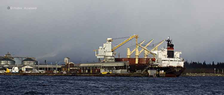
The Panama registered bulk carrier Azuma Phoenix is seen tied up at Kitimat harbour on the afternoon of Jan 9, 2012. In March 2013. the federal government announced it was making the private port of Kitimat into a public port. (Robin Rowland)
When the story of the Stephen Harper government is told, historians will say that the week of March 17 to 23, 2013, is remembered, not for the release of a lacklustre federal budget, but for day after day of political blunders that undermined Harper’s goal of making a Canada what the Conservatives call a resource superpower.
It was a week where spin overcame substance and spun out of control.
The Conservative government’s aim was, apparently, to increase support for the Enbridge Northern Gateway pipeline project with a spin campaign aimed at moving the middle ground in British Columbia from anti-project to pro-project and at the same time launching a divide and conquer strategy aimed at BC and Alberta First Nations.
It all backfired. If on Monday, March 17, 2013, the troubled and controversial Enbridge Northern Gateway project was on the sick list, by Friday, March 23, the Enbridge pipeline and tanker scheme was added to the Do Not Resuscitate list, all thanks to political arrogance, blindfolded spin and bureaucratic incompetence. The standard boogeymen for conservative media in Canada (who always add the same sentence to their stories on the Northern Gateway) “First Nations and environmentalists who oppose the project” had nothing to do with it.
Stephen Harper has tight control of his party and the government, and in this case the billion bucks stop at the Prime Minister’s Office. He has only himself to blame.
All of this happened on the northern coast of British Columbia, far out of range of the radar of the national media and the Ottawa pundit class (most of whom, it must be admitted, were locked up in an old railway station in the nation’s capital, trying interpret Finance Minister Jim Flaherty’s spreadsheets).
The story begins early on that Monday morning, at my home base in Kitimat, BC, the proposed terminal for Northern Gateway, when a news release pops into my e-mail box, advising that Natural Resources Minister Joe Oliver would be in nearby Terrace early on Tuesday morning for an announcement and photo op.
I started making calls, trying to find out if anyone in Kitimat knew about Oliver’s visit to Terrace and if the minister planned to come to Kitimat.
Visitors to Kitimat
I made those calls because in the past two years, Kitimat has seen a parade of visitors checking out the town and the port’s industrial and transportation potential. The visitors range from members of the BC provincial Liberal cabinet to the staff of the Chinese consulate in Vancouver to top executives of some of the world’s major transnational corporations (and not just in the energy sector). Most of these visits, which usually include meetings with the District of Kitimat Council and District senior staff as well as separate meetings with the Council of the Haisla Nation, are usually considered confidential. There are no photo ops or news conferences. If the news of a visit is made public, (not all are), those visits are usually noted, after the fact, by Mayor Joanne Monaghan at the next public council meeting.
It was quickly clear from my calls that no one in an official capacity in Kitimat knew that, by the next morning, Oliver would be Terrace, 60 kilometres up Highway 37. No meetings in Kitimat, on or off the record, were scheduled with the Minister of Natural Resources who has been talking about Kitimat ever since he was appointed to the Harper cabinet.
I was skeptical about that afternoon’s announcement/photo op in Vancouver by Transport Minister Denis Lebel and Oliver about the “world class” tanker monitoring.
After all, there had been Canadian Coast Guard cutbacks on the northwest coast even before Stephen Harper got his majority government. The inadequacy of oil spill response on the British Columbia coast had been condemned both by former Auditor General Sheila Fraser and in the United States Senate. The government stubbornly closed and dismantled the Kitsilano Coast Guard station. It’s proposing that ocean traffic control for the Port of Vancouver be done remotely from Victoria, with fixed cameras dotted around the harbour. Leaving controllers in Vancouver would, of course, be the best solution, but they must be sacrificed (along with any ship that get’s into trouble in the future, on the altar of a balanced budget).
The part of the announcement that said there would be increased air surveillance is nothing more than a joke (or spin intended just for the Conservative base in Alberta, Saskatchewan and the Toronto suburbs,that is not anyone familiar with BC coastal waters). Currently the Transport Canada surveillance aircraft are used on the coasts to look for vessels that are illegally dumping bilge or oil off shore. As CBC’s Paul Hunter reported in 2010, Transport Canada aircraft were used after the Gulf of Mexico oil disaster to map where the oil was going after it erupted from the Deepwater Horizon.
Given the stormy weather on the west coast (when Coast Guard radio frequently warns of “hurricane force winds”) it is highly unlikely that the surveillance aircraft would even be flying in the conditions that could cause a major tanker disaster. Aerial surveillance, even in good weather, will never prevent a tanker disaster caused by human error.
I got my first chance to look at the Transport Canada website in late afternoon and that’s when a seemingly innocuous section made me sit up and say “what is going on?” (I actually said something much stronger).
Public port
Public port designations: More ports will be designated for traffic control measures, starting with Kitimat.
(Transport Canada actually spelled the name wrong—it has since been fixed—as you can see in this screen grab).
Kitimat has been one of the few private ports in Canada since the Alcan smelter was built and the town founded 60 years ago (the 60th anniversary of the incorporation of the District of Kitimat is March 31, 2013).
The reasons for the designation of Kitimat as a private port go back to a complicated deal between the province of British Columbia and Alcan in the late 1940s as the two were negotiating about electrical power, the aluminum smelter, the building of the town and the harbour.
For 60 years, Alcan, later Rio Tinto Alcan, built, paid for and operated the port as a private sector venture. For a time, additional docks were also operated by Eurocan and Methanex. After Eurocan closed its Kitimat operation that dock was purchased by the parent company Rio Tinto. The Methanex dock was purchased by Royal Dutch Shell last year for its proposed LNG operation.
The announcement that Kitimat was to become a public port was also something that the national media would not recognize as significant unless they are familiar with the history of the port. That history is known only to current and former residents of Kitimat and managers at Rio Tinto Alcan.
The port announcement came so much out of left field; so to speak, that I had doubts it was accurate. In other words, I couldn’t believe it. I went to Monday evening’s meeting of District of Kitimat Council and at the break between the open and in-camera sessions, I asked council members if they had heard about Kitimat being redesignated a public port. The members of the district council were as surprised as I had been.
Back from the council meeting, I checked the Transport Canada news release and backgrounders. I also checked the online version of Bill C-57, the enabling act for the changes announced earlier that day. There was no mention of Kitimat in Bill C-57.
Tuesday morning I drove to Terrace for Joe Oliver’s 9 am photo op and the announcement at Northwest Community College (NWCC) that the government had appointed Douglas Eyford as a special envoy to First Nations for energy projects, an attempt on the surface to try and get First Nations onside for the pipeline projects, an appointment seen by some First Nations leaders as an attempt by the Harper government to divide and conquer.
As an on site reporter, I got to ask Oliver two questions before the news conference went to the national media on the phones.
In answer to my first question, Oliver confirmed that the federal government had decided to make Kitimat a public port, saying in his first sentence: “What the purpose is to make sure that the absolute highest standards of marine safety apply in the port of Kitimat.” He then returned to message track saying, “we have as I announced yesterday and I had spoken about before at the port of Vancouver we have an extremely robust marine safety regime in place but we want to make sure that as resource development continues and as technology improves, we are at the world class level. As I also mentioned there has never been off the coast of British Columbia a major tanker spill and we want to keep that perfect record.”
For my second question, I asked Oliver if he planned to visit Kitimat.
He replied. “Not in this particular visit, I have to get back [to Ottawa] There’s a budget coming and I have to be in the House for that but I certainly expect to be going up there.”
The question may not have registered with the national media on the conference call. For the local reporters and leaders in the room at Waap Galts’ap, the long house at Terrace’s Northwest Community College, everyone knew that Kitimat had been snubbed.
Back in Kitimat, I sent an e-mail to Colleen Nyce, the local spokesperson for Rio Tinto Alcan noting that Joe Oliver had confirmed that the federal government intended to make the RTA-run port a public port. I asked if RTA had been consulted and if the company had any comment.
Nyce replied that she was not aware of the announcement and promised to “look into this on our end.” I am now told by sources that it is believed that my inquiry to Nyce was the first time Rio Tinto Alcan, one of Canada’s biggest resource companies, had heard that the federal government was taking over its port.
The next day, Kitimat Mayor Joanne Monaghan told local TV news on CFTK the Kitimat community was never consulted about the decision and she added that she still hadn’t been able to get anyone with the federal government to tell her more about the plan.
Who pays for the navigation aids?
Meanwhile, new questions were being raised in Kitimat about two other parts of the Monday announcement.
New and modified aids to navigation: The CCG will ensure that a system of aids to navigation comprised of buoys, lights and other devices to warn of obstructions and to mark the location of preferred shipping routes is installed and maintained. Modern navigation system: The CCG will develop options for enhancing Canada’s current navigation system (e.g. aids to navigation, hydrographic charts, etc) by fall 2013 for government consideration.
Since its first public meeting in Kitimat, in documents filed with the Northern Gateway Joint Review Panel, in public statements and advertising, Enbridge has been saying for at least the past four years that the company would pay for all the needed upgrades to aids to navigation on Douglas Channel, Wright Sound and other areas for its tanker traffic. It is estimated that those navigation upgrades would cost millions of dollars.
Now days before a federal budget that Jim Flaherty had already telegraphed as emphasizing restraint, it appeared that the Harper government, in its desperation to get approval for energy exports, was going to take over funding for the navigation upgrades from the private sector and hand the bill to the Canadian taxpayer.
RTA not consulted
On Thursday morning, I received an e-mail from Colleen Nyce with a Rio Tinto Alcan statement, noting:
This announcement was not discussed with Rio Tinto Alcan in advance. We are endeavoring to have meetings with the federal government to gain clarity on this announcement as it specifically relates to our operations in Kitimat.
On Friday morning, Mayor Monaghan told Andrew Kurjata on CBC’s Daybreak North that she had had at that time no response to phone calls and e-mails asking for clarification of the announcement. Monaghan also told CBC that Kitimat’s development officer Rose Klukas had tried to “get an audience with minister and had been unable to.” (One reason may be that Oliver’s staff was busy. They ordered NWCC staff to rearrange the usual layout of the chairs at Waap Galts’ap, the long house, to get a better background for the TV cameras for Oliver’s statement).
Natural Resources Minister Joe Oliver (front far right) answers questions after his news conference at the Northwest Community College Long House, March 19, 2013. (Robin Rowland)
Monaghan told Kurjata, “I feel like it’s a slap in the face because we’re always being told that we’re the instrument for the whole world right now because Kitimat is supposed to be the capital of the economy right now. So I thought we’d have a little more clout by now and they’d at least tell us they were going to do this. There was absolutely no consultation whatsoever.”
By Friday afternoon, five days after the announcement, Transport Canada officials finally returned the calls from Mayor Monaghan and Rose Klukas promising to consult Kitimat officials in the future.
Monaghan said that Transport Canada told her that it would take at least one year because the change from a private port to a public port requires a change in legislation.
Transport Canada is now promising “extensive public and stakeholder consultation will occur before the legislation is changed,” the mayor was told.
On this Mayor Monaghan commented, “It seems to me that now they want to do consultation….sort of like closing the barn door after all of the cows got out!”
Blunder No 1. Pulling the rug out from Northern Gateway
Joe Oliver and the Harper government sent a strong political signal to Kitimat on Tuesday; (to paraphrase an old movie) your little town doesn’t amount of a hill of beans in this crazy world.
There are a tiny handful of people in Kitimat openly in favour of the Northern Gateway project. A significant minority are on the fence and some perhaps leaning toward acceptance of the project. There is strong opposition and many with a wait and see attitude. (Those in favour will usually only speak on background, and then when you talk to them most of those “in favour” have lists of conditions. If BC Premier Christy Clark has five conditions, many of these people have a dozen or more).
Oliver was speaking in Terrace, 60 kilometres from Kitimat. It is about a 40 to 45 minute drive to Kitimat over a beautiful stretch of highway, with views of lakes, rivers and mountains.
Scenic Highway 37 is the route to the main location not only for the controversial Northern Gateway pipeline but three liquefied natural gas projects, not to mention David Black’s proposed refinery half way between Terrace and Kitimat.
Why wouldn’t Kitimat be a must stop on the schedule for the Minister of Natural Resources? In Terrace, Oliver declared that Kitimat was to become a public port, run by the federal government. Although technically that would be the responsibility of Denis Lebel, the Minister of Transport, one has to wonder why the Minister of Natural Resources would not want to see the port that is supposedly vital to Canada’s economy? You have to ask why he didn’t want to meet the representatives of the Haisla Nation, the staff and council of the District of Kitimat and local business leaders?
Oliver has been going across Canada, the United States and to foreign countries promoting pipelines and tanker traffic, pipelines that would terminate at Kitimat and tankers that would send either bitumen or liquefied natural gas to customers in Asia.
Yet the Minister of Natural Resources is too important, too busy to take a few hours out of his schedule, while he is in the region, to actually visit the town he has been talking about for years.
He told me that he had to be in Ottawa for the budget. Really? The budget is always the finance minister’s show and tell (with a little help from whomever the Prime Minister is at the time). On budget day, Oliver would have been nothing more than a background extra whenever the television cameras “dipped in” on the House of Commons, between stories from reporters and experts who had been in the budget lockup.
According to the time code on my video camera, Oliver’s news conference wrapped at 9:50 a.m., which certainly gave the minister and his staff plenty of time to drive to Kitimat, meet with the representatives of the District, the Haisla Nation and the Chamber of Commerce and still get to Vancouver for a late flight back to Ontario.
On Tuesday, Joe Oliver’s snub pulled the political rug out from under the Northern Gateway supporters and fence sitters in Kitimat. Oliver’s snub showed those few people in Kitimat that if they do go out on a limb to support the Northern Gateway project, the Conservatives would saw off that limb so it can be used as a good background prop for a photo op.
Prince Rupert, Terrace and Smithers councils have all voted against the Northern Gateway project. Kitimat Council, despite some clear divisions, has maintained a position of absolute neutrality. Kitimat Council will continue to be officially neutral until after the Joint Review report, but this week you could hear the air slowly leaking out of the neutrality balloon.
Oliver may still believe, as he has frequently said, that the only people who oppose Northern Gateway are dangerous radicals paid by foreign foundations.
What he did on Tuesday was to make the opposition to Northern Gateway in Kitimat into an even more solid majority across the political spectrum.
Blunder No 2. Rio Tinto Alcan
It doesn’t do much for the credibility of a minister of natural resources to thoroughly piss off, for no good reason, the world’s second largest mining and smelting conglomerate, Rio Tinto. But that’s just what Joe Oliver did this week.
I am not one to usually have much sympathy with rich, giant, transnational corporations.
But look at this way, over the past 60 years Alcan and now Rio Tinto Alcan have invested millions upon millions of dollars in building and maintaining the Kitimat smelter and the port of Kitimat. RTA is now completing the $3.3 billion Kitimat Modernization Project. Then without notice, or consultation, the Conservative government—the Conservative government—announces it is going to take over RTA’s port operations. What’s more, if what Transport Canada told Mayor Joanne Monaghan is correct, the federal government is going to start charging RTA fees to use the port it has built and operated for 60 years.
Too often RTA’s London headquarters acts like it is still the nineteenth century and the senior executives are like British colonialists dictating to the far reaches of the Empire on what do to do.
No matter what you think of RTA, it boggles the mind, whether you are right wing, left wing or mushy middle, that the federal government simply issues a press release–a press release– with not even a phone call, not even a visit (even to corporate headquarters) saying “Hey RTA, we’re taking over.”
There’s one thing that you can be sure of, Rio Tinto Alcan’s lobbyists are going to be earning their fees in the coming weeks.
(One more point, even if there wasn’t a single pipeline project planned for Kitimat you would think that the Minister of Natural Resources would want to see what is currently the largest and most expensive construction project in Canada, a project that comes under his area of political responsibility).
It took five days, from the time of the minister’s news conference on Monday until Friday afternoon, for officials in Transport Canada to return phone calls from Mayor Joanne Monaghan and Rose Klukas, to explain what was going to happen to the Port of Kitimat.
This week was yet another example of the decay of Canadian democracy under Stephen Harper. Executives from Tokyo to Houston to the City of London quickly return phone calls from the District of Kitimat, after all Kitimat is where the economic action is supposed to be. At the same time, the federal government doesn’t return those calls, it shows that something really is rotten in our state.
Blunder No 5. LNG
There are three liquefied natural gas projects slated for Kitimat harbour, the Chevron-Apache partnership in KM LNG, now under construction at Bish Cove; the Royal Dutch Shell project based on the old Methanex site and the barge based BC LNG partnership that will work out of North Cove.
None of these projects have had the final go ahead from the respective company board of directors. So has the federal government thrown the proverbial monkey wrench into these projects? Will making Kitimat a public port to promote Enbridge, help or hinder the LNG projects? Did the Ministry of Natural Resources even consider the LNG projects when they made the decision along with Transport Canada to take over the port?
And then there’s…..
Kitimat has a marina shortage, especially since RTA closed the Moon Bay Marina. The only one left, the MK Bay Marina, which is straining from overcapacity, is owned by the Kitimat-Stikine Regional District. That means there will be another level of government in any talks and decisions on the future of the Kitimat harbour. There are also the controversial raw log exports from nearby Minette Bay.
Although Transport Canada has promised “extensive public and stakeholder consultation,” one has to wonder how much input will be allowed for the residents of Kitimat and region, especially the guiding and tourism industries as well as recreational boaters. After all, the Harper government is determined to make Kitimat an export port for Alberta and the experience of the past couple of years has shown that people of northwest count for little in that process. Just look at the Northern Gateway Joint Review, which more and more people here say has no credibility.
Big blunder or more of the same?
I’ve listed five big blunders that are the result of the decision by the Harper government to turn Kitimat into a public port.
Are they really blunders or just more of the same policies we’ve seen from Stephen Harper since he became a majority prime minister?
This is a government that has muzzled scientific research and the exchange of scientific ideas. The minister who was in the northwest last week, who has demonized respect for the environment, is now squeezing the words “science” and “environment” anywhere into any message track or speech anyway he can.
That’s just the point. Joe Oliver’s fly-in, fly-out trip to Terrace was not supposed to have any substance. Changing the chairs at the Waap Galts’ap long house showed that it was more important to the Harper government to have some northwest coast wall art behind Joe Oliver for his photo op than it was to engage meaningfully with the northwest, including major corporations, First Nations and local civic and business leaders.
Joe Oliver’s visit to Terrace was an example of government by reality television. The decision to change the private port of Kitimat into a public port was another example of Harper’s government by decree without consulting a single stakeholder. The problem is, of course, that for decades to come, it will be everyone in northwest British Columbia who will be paying for those 30 second sound bites I recorded on Tuesday.
Epilogue: Alcan’s legacy for the socialist Prime Minister, Stephen Harper
If an NDP or Liberal government had done what Harper and Oliver did on Monday, every conservative MP, every conservative pundit, every conservative media outlet in Canada would be hoarse from screaming about the danger from the socialists to the Canadian economy.
That brings us to the legacy left by R. E. Powell who was president of Alcan in the 1940s and 50s as the company was building the Kitimat project.
As Global Mission, the company’s official history, relates, in 1951, Alcan signed an agreement with the British Columbia provincial government, that “called upon the company to risk a huge investment, without any government subsidy or financial backing and without any assured market for its product.”
According to the book, Powell sought to anticipate any future problems, given the tenor of the times, the possible or even likely nationalization of the smelter and the hydro-electric project.
So Powell insisted that the contract signed between Alcan and the province include preliminary clauses acknowledging that Alcan was paying for Kitimat without a single cent from the government:
Whereas the government is unwilling to provide and risk the very large amounts of money required to develop those water powers to produce power for which no market now exists or can be foreseen except through the construction of the facilities for the production of aluminum in the vicinity and….
Whereas the construction of the aluminum plant at or near the site of the said waterpower would accomplish without risk or to the GOVERNMENT the development power, the establishment of a permanent industry and the new of population and….
(Government in all caps in the original)
…the parties hereto agree as follows (the agreement, water licence and land permit)
Powell is quoted in the book as saying:
I asked the political leaders of BC if the government would develop the power and sell the energy to Alcan and they refused. We had to do it ourselves. Someday, perhaps, some politician will try to nationalize that power and grab it for the state. I will be dead and gone but some of you or your successors at Alcan may be here, and I hope the clauses in the agreement, approved by the solemn vote of the BC legislature, will give those future socialists good reason to pause and reflect.
In the late 1940s and early 1950s, the federal government had very little to do with the Kitimat project. With the declaration that Kitimat will be a public port, the federal government comes to the party 60 years late. But one has to wonder if the late Alcan president, R.E. Powell, ever considered that the “future socialists” he hoped would “pause and reflect” would be members of Canada’s Conservative party, Stephen Harper, Joe Oliver and Denis Lebel?
EmergencyInfoBC Please be advised that @EmergencyInfoBC is the only authorized emergency alert feed for Gov’t of BC.
Tweet Thu 8 Nov 11 48
The British Columbia Solicitor General’s department is asking northwest municipalities to “clarify the initial response actions” to the October 27 2012, magnitude 7.7 earthquake off Haida Gwaii and the resulting tsunami warning.
A covering letter to municipalities from Lori Wannamaker BC Deputy Solicitor General says the province is reviewing the response to the earthquake and tsunami and is “seeking input from affected community leaders.” The package includes a letter sent to Emergency Program Coordinators across British Columbia, adding: “Input will be sought in an endeavour to hear from those directly impacted as a measure of enhancing our operations and response,” adding. “Events like present all levels of government with a learning opportunity.”
In the main letter to the municipalities outlining emergency procedures, the department also offers a time line of its response to the incident.
Clarify the initial response actions
The package sent to municipalities by Rebecca Derlinger, Assistant Deputy Minister /Fire and Emergency Management Coordinator, opens by saying: “The earthquake/tsunami event on October 27, 2012 demonstrated the high level of emergency preparedness that has been undertaken by local governments in BC. Elected officials and emergency managers in all impacted communities deserve praise for a timely and effective response that was undertaken, including evacuations.”
But in the next paragraph the letter goes on to say: “Prior to the completion of the provincial debrief process, we would like to clarify the initial response actions of local government emergency management personnel including how information should be managed after an earthquake that impacts BC.”
The letter also says that “Local governments must complete a hazard risk and vulnerability analysis for their communities according to the Emergency Program Act and regulations, keeping in mind that all parts of British Columbia have a risk of earthquake impacts. Coastal communities have the added risk of tsunami.”
The letter then outlines three scenarios for various communities
Significant earthquake is felt in a community located in an area with tsunami risk
Earthquake is not felt, however, a community is located in an area with tsunami risk (teletsunami)
Earthquake is felt in a community that is not located in area that has tsunami risk
In all three scenarios it says Emergency Management BC “will provide the general public with ongoing situational awareness through:
EmergencyInfoBC blogsite
Social media such as Twitter
Mainstream media (press conferences and releases)
For areas such as Kitimat, which is in a possible tsunami zone, the letter advises “Local governments should undertake the following emergency response activities immediately following a significant earthquake (do not wait for official notification)
Activate their local emergency response plans and if deemed necessary
Active local first responders
Undertake public alerting and initiate evacuations of low lying areas
Open an emergency operations centre in a safe location
Report to EMBC
Ensure ongoing public messaging to their citizens
Gather information to develop situational awareness
For areas that don’t feel the earthquake, the province recommends
Local governments should undertake…emergency response activities immediately following the receipt of a West Coast Alaska Tsunami Warning Centre (or WCATTWC) and/or EMBC notification of a potential tsunami event. It then calls on local emergency officials to follow the same procedure outlined above “if a notification indicates an increased risk of a tsunami (warning or advisory only)
As you can see from the Twitter profile, Emergency Info BC works during normal office hours, Monday to Friday unless there is a declared emergency
The warnings October 27
In the letter the province outlines a time line of how the emergency system worked on October 27.
It says the provincial Tsunami Notification plan was activated at 8:10 pm. October 27, approximately four minutes after the earthquake.
In a provincial acronym soup it then says
The EMBC (Emergency Management BC) Emergency Coordination Centre initiated an internal resource request to activate the PECC (Provincial Emergency Coordination Centre) and the PREOCs (Provincial Regional Operations Centres).
EMBC and Temporary Emergency Assignment Management System (TEAMS) staff were in attendance at PECC and PREOCs by 8:33 pm.
“Based on the initial bulletin from WCATTWC, social media staff sent out a message via Twitter” at 8:48 pm At that time EMBC regional offices began contacting communities with potential tsunami risk by telephone. “Subject matter experts from Natural Resources Canada and Canadian Hydrographic Service were contacted by PECC at 8:30 pm and at 9 pm to review the information received from WCATWC.
“Based on these discussions, the PENS (Provincial Emergency Notification) was initiated at 9:05 while efforts to make contact with those communities under tsunami warning continued.
At 10:45 pm a media conference call was held by the Minister of Justice.
The letter continues to say that conference calls were held with EMBC, US state emergency management offices, and the West Coast Alaska Tsunami Warning Centre hourly until the final cancellation of the west coast warning by WCATWC at 2:47 am Sunday morning and by the province at 3:03 am
It concludes “Staff responsible for social media were actively engaged in informing the public.”
Denlinger’s letter then goes on to note that the provincial debrief will include “a discussion on the information flow from the province to emergency management stakeholders and the public (for example the use of social media as a communications tool for public awareness of the event)… This information….will assist in the creation of a provincial after action report and in the enhancement of subsequent provincial earthquake and tsunami response plans.”
At 6:06 I received an automatic text message from the West Coast Alaska Tsunami Warning Centre
Tsunami Info Stmt: M6.3 085Mi SW Port Alice, British Columbia 1802PST Nov 7: Tsunami NOT expected #WCATWC
At 6:07 I received an automatic tweet from Canadaquakes : @CANADAquakes: Automatic detection of seismic event: magnitude 4.4 – 7 Nov 18:01 PST – PORT HARDY, BC region
At 6:15, I received the WCATWC message on Twitter that I had received 9 minutes earlier via text
Tsunami Info Stmt: M6.3 085Mi SW Port Alice, British Columbia 1802PST Nov 7: Tsunami NOT expected #WCATWC
@EmergencyInfoBC retweets the WCATWC message
At 6:27 Canada quakes updated their tweet with corrected information: @CANADAquakes: EARTHQUAKE Mag=6.3 on 07 Nov at 18:01 PST. Details : http://t.co/OL9RTPKC 101 km SSW of Port Alice, BC
@EmergencyInfoBC retweets the CANADAquakes message
Analysis The province didn’t get it
Read between the lines of the Solicitor General’s letter and a couple of things stand out. While at first the officials say things went fine according to procedures in the book, events appear to show that in practice, the system didn’t work as well as expected on the night of October 27.
First the province, reminds municipalities of that they “must complete a hazard risk and vulnerability analysis for the communities.”
Second, while EM BC social media staff were, according to the letter, “were actively engaged in informing the public,” there was actually scant evidence of that during the crucial first 90 minutes after the earthquake on Haida Gwaii. While the emergency coordination officials and bureaucrats apparently were well informed about what was happening, the public was not. As I pointed out in an earlier post, differences between the US and Canadian warning systems contributed to the confusion. As well there was a problem on both Twitter and Facebook of rumour, misleading and false information being posted on social media during that crucial 90 minutes.
The line about the “the use of social media as a communications tool for public awareness of the event” is a clear indication that not all went well with the EM BC Twitter feed the night of the Haida Gwaii earthquake.
While Emergency Info BC is a sort of blog, again you have to know to go there and it is only active during an emergency. There were no posting on the night of the earthquake and tsunami. The last “blog” was during the Johnson’s Landing landslide evacuation in July 2012, and even that doesn’t give much information. Looks like Emergency Info doesn’t understand that a blog entry that says “no danger, nothing much is happening” is just as important as evacuation instructions.
The main website is Emergency Management BC, with a link to the Info site—if there is an emergency—not exactly a prime example of web design for someone in a hurry, whether an official, the media or the public, since it was what the web calls “brochure ware.”
The first indication of whether or not there would be major danger to the BC coast on Oct. 27 was at Langara Island at 9:16 pm. Local officials in northwest BC were monitoring Langara and the relatively low surge indicated–at least at that time– that danger was not as great as feared. Yet it was only seven minutes earlier that EM BC activated the Provincial Notification Program at 9:05, and that was an hour after it was known that the earthquake was 7.7 in magnitude, which had the potential for catastrophic damage. The tweets that I saw about the small surge at Langara, came from Prince Rupert. It is in a situation like the Langara monitoring that the Emergency Info blog would have been relevant.
The need for constant official updates is clear. Earthquakes do not work 8:30 to 4:30, Monday to Friday. The province has to be able to activate emergency notification much faster. If a web journalist whether working for the mainstream media or a responsible individual on a small site can tweet or post in seconds, usually working from a home office or even a smart phone, emergency officials can do the same.
In these days, travel by government officials is often frowned upon. A couple of months from now, when New York and New Jersey have recovered from the Superstorm Sandy and this weeks Nor’easter, a visit from BC emergency officials is in order to see how it is done.
Kitimat, BC and New York City had one thing in common this week, the misuse and use of social media, Twitter and Facebook, that spread both accurate warnings and dangerous misinformation about an impending disaster. In the case of New York and the surrounding area, it was Superstorm Sandy that caused widespread devastation. For Kitimat it was the tsunami warning after the 7.7 earthquake off Haida Gwaii and no damage but a lot of worry for residents.
New York has a population of millions, it is the media centre for the United States, and much of the U.S. Northeast coast is still recovering from the horrendous damage from Superstorm Sandy.
Kitimat has a population of about 8,000 and my home town is off the media radar except when the Enbridge Northern Gateway pipeline issue pops up on the national assignment desks. If the October 27, 2012 tsunami from the Haida Gwaii earthquake did come up Douglas Channel to Kitimat harbour, it was so minimal that any water rise was scarcely noticed.
In one way New York (the state and the city) plus New Jersey and other states were ahead of Kitimat. In the US, there were numerous official sources on Twitter and Facebook, as well as those ubiquitous live TV news conferences with New York Mayor Michael Bloomberg or various state governors.
On October 27, neither Kitimat nor the nearby town of Terrace had any official emergency outlets on social media. In Kitimat, that may change as early as this Monday when District Council considers what happened last Saturday night.
It has been documented that there was no official response from Emergency Management British Columbia (still largely known under its former name Provincial Emergency Program) until an hour after the first earthquake report from the US Geological Survey. Only sometime later did BC’s provincial emergency officials hold a short conference call with reporters. (At the time the BC Liberals were holding a policy convention at Whistler. After the conference call, TV reporters at the convention in Whistler were doing live reports with taped clips of Attorney General Shirley Bond. It should have been easy for Bond and other senior government officials, including Premier Christy Clark–who is plummeting the polls– to hold a live news conference just as US state governors and mayors did later in the week when it came to Superstorm Sandy)
So in that hour of silence from the BC government, one question that has to be raised is: Were the tsunami warnings so completely uncoordinated–at least as far as the public is concerned– that that was one cause of the misinformation and inaccurate information on Twitter and Facebook? Or did confusing information from authorities simply compound and amplify the social media misinformation that was already spreading across British Columbia and around the world?
Here in the northwest, the two area fire chiefs Trent Bossence of Kitimat and John Klie of Terrace have said after the quake that landline phones and some cell phones were out, in some areas up to an hour after the first shock. Klie told CFTK’s Tyler Noble on Open Connection that after the landline phones came back up the Terrace fire department was flooded with calls from people “who wanted it now.” The ability of firefighters to get information was then delayed “because so many people were trying to get through.”
Kitimat has the advantage of being a small town. Emergency services already had scheduled a volunteer recruiting session last Monday night (October 29) for Emergency Social Services–the folks who run, coordinate and work in reception centres during an emergency–so it was easy to turn that meeting into a earthquake/tsunami warning post mortem. (Imagine that happening in New York?)
The most important issue on Saturday night was the false information on both Facebook and Twitter that the Kildala neighbourhood was being evacuated due to the tsunami warning. Other false information on social media indicated that the giant Bechtel work camp at the Rio Tinto Alcan Kitimat Modernization Project was also being evacuated.
As Kitimat’s Emergency Plan Coordinator Bob McLeod told the earthquake post mortem about the information on Facebook and Twitter:
Kitimat Emergency Coordinator Bob McLeod at the earthquake postmortem Oct. 29, 2012 (Robin Rowland/Northwest Coast Energy News)
“Your aim is to be saving people, and you’re not saving people. There was one case where someone was going around banging on doors in Kildala, telling them to get out. I think it was over when he was in the lockup that night. But this is the type of foolishness that goes on. You have people going on Facebook saying ‘Alcan’s been evacuated. they’re evacuating Kildala.’ I am going to be generous and say it is misinformation… It was a blatant lie. And that does not help.”
(For those outside Kitimat you can check the town on Google maps) As seen on this screen grab, Kildala is a low lying part of town. The area north of Highway 37 is higher on a hill. Closer to the ocean at Douglas Channel are the Bechtel/RTA Kitimat Modernization Project work camps.
After driving from the village to the town, McFarlane told the meeting that he stopped at the town viewpoint where “people were telling me they had already been evacuated out of the Kildala neighbourhood, so my first stop after that was the fire department.” The fire hall is about a couple of blocks from the viewpoint, so it was easy to get accurate information from the fire department.
McFarlane continued, “I found the night of the earthquake that no information is just as bad as wrong information. People were calling me on my cell saying why does the Kitimat Daily say we have to evacuate.” That is because the Daily republished a warning from the Pacific Tsunami Warning Centre that “said tsunami warning, evacuation for the north coast. People were saying we’re on the north coast, we got to go.”
I was about fifteen to twenty minutes behind McFarlane in reaching town. (I did not leave Kitamaat Village until after we heard the first tsunami warning.) As soon as I got to back in cell range, my cell phone started to beep with saved messages from my TV and radio news clients calling for information. When I got to my home office, my landline was still dead and would be for about another twenty minutes. The only source of information at that point was Google News, Facebook and Twitter.
I saw the initial, and it turns out general, warning from the Pacific Tsunami Warning Center. Soon I was also getting what I hoped was more specific information on my marine radio from the Canadian Coast Guard Prince Rupert communications station.
But that, too was somewhat confusing. That Coast Guard advisory mentioned various zones, for example, Zone A and Zone B, but there was little specific context and that point I had no idea what Zone A meant. Prince Rupert Coast Guard Radio then went on to say evacuate low lying coastal areas. (transcript below)
With that confusion, and mindful of “when in doubt, leave it out,” I did not mention the zone system in any information I posted on Facebook and Twitter that night. I only retweeted official information or tweets from reporters I knew and trusted (and I did not see any tweeted official information from the province with a link to the page that identifies the official tsunami zones)
From the interview on CFTK, it appears that both the Kitimat and Terrace fire departments were also getting inadequate information.
“We went to our normal place to look EM BC (Emergency Management BC) and there was nothing there,so we went to Plan B to get information and went on from there,” Bossence told Tyler Noble.
Klie said: “We struggle with that every disaster big or small. Social media, I think emergency organizations are trying to tap into more and more. Up north we may be a little behind the eight ball but sure enough Twitter and Facebook information is out there instantly. Looking at Facebook with my son, I saw that they were evacuating whole cities and I knew that was not true. Because of my experience I can filter some of the information, but there is so much information out there that it’s hard to filter what’s real and not real. It’s an area where emergency coordinators have to get into because its the fastest way of getting information out.”
“Once the phone system came back online at the Fire Hall we got a flood of phone calls,” Bossence told CFTK, “it was nonstop and it was people wanting to know. ‘What’s going on? What are we going to do? Are we leaving?’ and they’re giving us ‘This is what is what I’m reading, this is what I’m being texted, on Facebook they’re saying we’re supposed to evacuate’ adding to that we had an individual going around claiming he was a fire department, he was going door to door and telling people to evacuate. That was the added issue we had to deal with. It was definitely misinformation and a sense of urgency that was coming out through the social network (and eventually the media) was big problem for us.”
In Kitimat, I was told about the man going door to door with inaccurate information and as soon as I confirmed it with reliable official sources, I posted that on both Twitter and Facebook, emphasizing there was, at that time, no evacuation order.
But every situation is different. In contrast, in Superstorm Sandy, another story about men going door to door in Williamsburg, a section of Brooklyn was not true, as can be seen in an article summing problems with Twitter in New York, where Jared Keller of Bloomberg reported
I experienced this firsthand during Hurricane Sandy. After retweeting a message warning about muggers in Williamsburg dressed as Con Ed workers as an experiment, I received two sceptical responses checking the claim within 15 minutes, both from people who work in the media industry and spend a significant amount of time on Twitter. Within an hour, I received a mass text message from friends of mine who aren’t completely plugged into the social Web with the same warning: “I just read a news alert of two separate reports of people posing as coned workers, knocking on people’s door and robbing them at gunpoint in Williamsburg. I just want to pass along the info. Stay safe and maybe don’t answer your door.” Two other friends responded with thanks.
Keller goes on to stay “I know a lot of people, especially on Facebook, who end up believing whatever they see first,” says Kate Gardiner, a social media journalist. “It’s almost impossible to track something back to its point of origin there.”
With the earthquake and tsunami warning Saturday night, Twitter misinformation spread internationally. The first hashtag I saw was #bcquake, but as the the tsunami warning gained traction (especially after the warning was extended from BC and Alaska to Washington, Oregon and California and then to Hawaii) the more common hashtag #tsunami became prominent. As people outside BC began tweeting, they began using #Canadaquake and soon #prayforcanada also began to trend. Completely inaccurate information spread on #prayforcanada (believed to have originated in Indonesia) that it was Vancouver, not the north coast that had been hit by the 7.7 magnitude earthquake.
Are you in the Zone?
At this point, one question has to be asked. The spread of information, first the well-intended but wrong, second just rumour and third, the deliberately misleading, has been seen in social media not only during the earthquake and tsunami on the West Coast last weekend, and during Superstorm Sandy on the East Coast but all the way back to the 2004 Christmas tsunami in Southeast Asia.
For the west coast in 2012, however, how much of the problem of misinformation on social media during the earthquake and tsunami warning was the fault of confusing information from the authorities? Just how were people going to interpret such general terms as “north coast” and “low lying areas.”?
From the BC Provincial Emergency Program you have to ask “What is Zone A?” It turns out by checking a day or so later that the province of British Columbia has created Tsunami Identification Zones.
Before October 27, it is likely no one outside of the provincial bureaucracy had ever heard of the provincial tsunami zones. At that time no one in BC, either on Twitter or Facebook or through the media was identifying the BC Tsunami Zones for the public. Later on, the television networks put up maps showing Zones A and B —but that was only good if you had power and were watching the right channel. Kitimat Daily and Terrace Daily posted an official update at 10:42 long after the danger was past explaining the Zone system. It was no good at all if you were listening to news reports on radio or to Prince Rupert Coast Guard Radio on a fishing boat and had no access to the actual maps.
Compounding the confusion is that the US system appears to be very different from the Canadian.
Also the US system has two levels of warning. The Pacific Tsunami Warning Center sends out general warnings but hands over for a more specific warning map from the Alaska -based West Coast and Alaska Pacific Tsunami warning centre. It uses its own system of lettered and numbered zones for the west coast of North America. (See the Oct 27 tsunami advisory here Note it is a Google maps plugin.)
Fisheries management zones as defined by the Department of Fisheries and Oceams (DFO)
So in case of a tsunami warning, Kitimat is in Zone B for the province of British Columbia and the Provincial Emergency Program and in Zone BZ921 for the West Coast and Alaska Tsunami Warning Centre. For the much more familiar fisheries management areas Kitimat is in Zone 6 (which of course has nothing to do with a tsunami, it’s simply the coastal zone system everyone is familiar with)
Adding to the confusion is the fact that the EM British Columbia map shows Terrace, far inland up the Skeena River is considered in Zone A, along with Prince Rupert for tsunami warnings (if a tsunami was big enough to reach Terrace along the Skeena River valley, then I can only assume that much of the west coast of North America would have already been wiped out).
The Monday Post mortem
At the Monday, October 29 post mortem, when McLeod outlined the events of October 27, he began by looking back three weeks, saying, “I have feeling of frustration about a couple of things. October 7, I took 4,000 brochures [How Prepared Are you if Disaster Strikes?] down to the post office to mail out to the residents of Kitimat, They were all delivered by the post office. On Sunday, I had people coming to me and saying what are we supposed to do in the case of an earthquake? It is really, really difficult to get people interested.”
McLeod said that after he felt the earthquake, he went online to check information and then went up to the fire hall, which is Kitimat’s emergency coordination centre. There he met Fire Chief Bossence, his deputy, the RCMP detachment commander Staff Sergeant Steve Corp and representatives from Bechtel and the Rio Tinto Alcan modernization project.
“For the first little while we were going on line trying to get information. The usual method of dissemination getting information it comes from the West coast and Alaska tsunami warning system, then it goes to Victoria, Victoria gives it to the geophysical specialists and they will confirm or deny what ever the information and then it goes to the Provincial Emergency Program and they shoot it out to coastal communities.
“While in this case you’re working with what you find out from different sources and you are trying to determine how reliable these sources are.”
“In our case, for me the first thing you do when you get word of an impending tidal wave [tsunami] action is check the tide. If you’re on a high tide, it’s a different situation than a low tide
“The movie version of a tidal wave is this 50 foot mountain of water roaring along and this is not what is going to happen particularly in Douglas Channel because of the depth. So you are going to see a surge such as we saw in Japan and it will be an increasing surge of water.
“We were told that potentially some sort of surge hitting Langara [the northern most island in Haida Gwaii) at 9:16, 9:16 came and went and there was no notification of a noticeable surge of water. So were down to a non event and we were on a receding tide.” (See advisory below)
“Misinformation going out is not helpful,” McLeod said. “You’ve got to set up a stream of how you get information out to people and it’s a valid point. The District Website, the Facebook page, something like that can get information out. But again if you lose power where do get it? Text can work even locally with cell phones. if you’re in a dead area with a cell phone, you can still get text”
McLeod then asked the audience, mainly people ranging from their thirties to seventies if they text. Only four or five people put up their hands. “You people are going to be saved, the rest of us…” McLeod quipped.
If a conclusion can be drawn from the earthquake and tsunami warning in the Kitimat region on October 27, it’s not just that in an emergency inaccurate, incomplete or malicious information can spread a the speed of light on social media, it’s worse that incomplete, inadequate and confusing information from the authorities is amplified and distorted by rapid posting on social media. That concept is not new for anyone who has tried the phone chain game where the outcome is often completely different from the start.
If Gardiner is correct when she says “I know a lot of people, especially on Facebook, who end up believing whatever they see first,” the BC government delays made everything worse. People Tweeted the first thing they saw and the first thing people saw came from multiple and often conflicting sources. Add that to those Tweets that were exaggeration, rumour and lies.
The problem in 2012 it is not one person talking to one person talking to one person, it is a Tweet or Facebook posting that go out to thousands, or millions of people and that’s a lot more dangerous.
McLeod said the post mortem who said emergency services is trying to get more information out to public, but he added. “The unfortunate part is that if you publish it this week, by Christmas no one will remember. If you start throwing it out every week, it becomes like a stop sign at the end of the street. Nobody sees it.”
(Coming next. If Kitimat had to evacuate)
Transcript of Prince Rupert Coast Guard Radio tsunami warning.
Pan pan. Pan pan. This is Prince Rupert Coast Guard Radio, Prince Rupert Coast Guard Radio. Warning for coastal British Columbia issued by Environment Canada on behalf of the British Columbia Provincial Emergency Program at 2057 Pacific Daylight Time Saturday 27 October. Tsunami warning for Zone A, the north coast and Haida Gwaii,Zone B, the central coast and including Bella Coola, Bella Bella and (unintelligible). A tsunami warning has been issued, if you are in a low-lying area coastal area, you are at risk and must move to higher ground or inland now.
Do not return until directed to do so. Closely monitor local radio stations for additional information from local authorities. Please minimize phone use in affected areas, for further information contact the provincial emergency program at website www. papa echo papa period bravo charlie period charlie alpha.Prince Rupert Coast Guard Radio over.
TSUNAMI BULLETIN NUMBER 003
PACIFIC TSUNAMI WARNING CENTER/NOAA/NWS
ISSUED AT 0341Z 28 OCT 2012
THIS BULLETIN APPLIES TO AREAS WITHIN AND BORDERING THE PACIFIC
OCEAN AND ADJACENT SEAS…EXCEPT ALASKA…BRITISH COLUMBIA…
WASHINGTON…OREGON AND CALIFORNIA.
… TSUNAMI INFORMATION BULLETIN …
THIS BULLETIN IS FOR INFORMATION ONLY.
THIS BULLETIN IS ISSUED AS ADVICE TO GOVERNMENT AGENCIES. ONLY
NATIONAL AND LOCAL GOVERNMENT AGENCIES HAVE THE AUTHORITY TO MAKE
DECISIONS REGARDING THE OFFICIAL STATE OF ALERT IN THEIR AREA AND
ANY ACTIONS TO BE TAKEN IN RESPONSE.
AN EARTHQUAKE HAS OCCURRED WITH THESE PRELIMINARY PARAMETERS
ORIGIN TIME – 0304Z 28 OCT 2012
COORDINATES – 52.9 NORTH 131.9 WEST
DEPTH – 10 KM
LOCATION – QUEEN CHARLOTTE ISLANDS REGION
MAGNITUDE – 7.7
EVALUATION
NO DESTRUCTIVE WIDESPREAD TSUNAMI THREAT EXISTS BASED ON
HISTORICAL EARTHQUAKE AND TSUNAMI DATA.
HOWEVER – THE WEST COAST/ALASKA TSUNAMI WARNING CENTER HAS
ISSUED A REGIONAL WARNING FOR COASTS LOCATED NEAR THE EARTHQUAKE.
THIS CENTER WILL CONTINUE TO MONITOR THE SITUATION BUT DOES NOT
EXPECT A WIDER THREAT TO OCCUR.
THIS WILL BE THE ONLY BULLETIN ISSUED FOR THIS EVENT UNLESS
ADDITIONAL INFORMATION BECOMES AVAILABLE.
THE WEST COAST/ALASKA TSUNAMI WARNING CENTER WILL ISSUE PRODUCTS
FOR ALASKA…BRITISH COLUMBIA…WASHINGTON…OREGON…CALIFORNIA.
BULLETIN
PUBLIC TSUNAMI MESSAGE NUMBER 2
NWS WEST COAST/ALASKA TSUNAMI WARNING CENTER PALMER AK
834 PM PDT SAT OCT 27 2012
THE MAGNITUDE IS UPDATED TO 7.7. THE WARNING ZONE REMAINS THE
SAME.
…THE TSUNAMI WARNING CONTINUES IN EFFECT FOR THE COASTAL
AREAS OF BRITISH COLUMBIA AND ALASKA FROM THE NORTH TIP OF
VANCOUVER ISLAND BRITISH COLUMBIA TO CAPE DECISION
ALASKA/LOCATED 85 MILES SE OF SITKA/…
…THIS MESSAGE IS INFORMATION ONLY FOR COASTAL AREAS OF
CALIFORNIA – OREGON – WASHINGTON AND BRITISH COLUMBIA FROM
THE CALIFORNIA-MEXICO BORDER TO THE NORTH TIP OF VANCOUVER
ISLAND BRITISH COLUMBIA…
…THIS MESSAGE IS INFORMATION ONLY FOR COASTAL AREAS OF
ALASKA FROM CAPE DECISION ALASKA/LOCATED 85 MILES SE OF
SITKA/ TO ATTU ALASKA…
A TSUNAMI WARNING MEANS… ALL COASTAL RESIDENTS IN THE WARNING
AREA WHO ARE NEAR THE BEACH OR IN LOW-LYING REGIONS SHOULD MOVE
IMMEDIATELY INLAND TO HIGHER GROUND AND AWAY FROM ALL HARBORS AND
INLETS INCLUDING THOSE SHELTERED DIRECTLY FROM THE SEA. THOSE
FEELING THE EARTH SHAKE… SEEING UNUSUAL WAVE ACTION… OR THE
WATER LEVEL RISING OR RECEDING MAY HAVE ONLY A FEW MINUTES BEFORE
THE TSUNAMI ARRIVAL AND SHOULD MOVE IMMEDIATELY. HOMES AND
SMALL BUILDINGS ARE NOT DESIGNED TO WITHSTAND TSUNAMI IMPACTS.
DO NOT STAY IN THESE STRUCTURES.
ALL RESIDENTS WITHIN THE WARNED AREA SHOULD BE ALERT FOR
INSTRUCTIONS BROADCAST FROM THEIR LOCAL CIVIL AUTHORITIES.
EARTHQUAKES OF THIS SIZE ARE KNOWN TO GENERATE TSUNAMIS.
AT 804 PM PACIFIC DAYLIGHT TIME ON OCTOBER 27 AN EARTHQUAKE WITH
PRELIMINARY MAGNITUDE 7.7 OCCURRED 25 MILES/40 KM SOUTH OF
SANDSPIT BRITISH COLUMBIA.
EARTHQUAKES OF THIS SIZE ARE KNOWN TO GENERATE TSUNAMIS.
IF A TSUNAMI HAS BEEN GENERATED THE WAVES WILL FIRST REACH
LANGARA ISLAND BRITISH COLUMBIA AT 916 PM PDT ON OCTOBER 27.
ESTIMATED TSUNAMI ARRIVAL TIMES AND MAPS ALONG WITH SAFETY RULES
AND OTHER INFORMATION CAN BE FOUND ON THE WEB SITE
WCATWC.ARH.NOAA.GOV.
TSUNAMIS CAN BE DANGEROUS WAVES THAT ARE NOT SURVIVABLE. WAVE
HEIGHTS ARE AMPLIFIED BY IRREGULAR SHORELINE AND ARE DIFFICULT TO
FORECAST. TSUNAMIS OFTEN APPEAR AS A STRONG SURGE AND MAY BE
PRECEDED BY A RECEDING WATER LEVEL. MARINERS IN WATER DEEPER
THAN 600 FEET SHOULD NOT BE AFFECTED BY A TSUNAMI. WAVE HEIGHTS
WILL INCREASE RAPIDLY AS WATER SHALLOWS. TSUNAMIS ARE A SERIES OF
OCEAN WAVES WHICH CAN BE DANGEROUS FOR SEVERAL HOURS AFTER THE
INITIAL WAVE ARRIVAL. DO NOT RETURN TO EVACUATED AREAS UNTIL AN
ALL CLEAR IS GIVEN BY LOCAL CIVIL AUTHORITIES.
PACIFIC COASTAL REGIONS OUTSIDE CALIFORNIA/ OREGON/ WASHINGTON/
BRITISH COLUMBIA AND ALASKA SHOULD REFER TO THE PACIFIC TSUNAMI
WARNING CENTER MESSAGES FOR INFORMATION ON THIS EVENT AT
PTWC.WEATHER.GOV.
THIS MESSAGE WILL BE UPDATED IN 30 MINUTES OR SOONER IF
THE SITUATION WARRANTS. THE TSUNAMI MESSAGE WILL REMAIN
IN EFFECT UNTIL FURTHER NOTICE. FOR FURTHER INFORMATION STAY TUNED
TO NOAA WEATHER RADIO… YOUR LOCAL TV OR RADIO STATIONS… OR SEE
THE WEB SITE WCATWC.ARH.NOAA.GOV.
$$
Did the media over react to the earthquake and tsunami warning?
There were also numerous Tweets on October 27, accusing the media of over reacting. The Haida Gwaii quake was 7.7 magnitude. Compare that to the Haiti earthquake on January 12, 2010 which was 7.0. The Christ Church, New Zealand earthquake on February 27, 2011 which caused major damage was 6.3 magnitude. So the Haida Gwaii earthquake was a major event. The tsunami warning that eventually reached as far off as Hawaii had to be taken seriously.
Fortunately Haida Gwaii is sparsely populated and there was minimal damage largely because most of the houses and buildings are wood and can absorb some of the shaking from an earthquake.
Given the tsunami damage in Southeast Asia in 2004 and in Japan in 2011, no media organization could ignore the developing story.
If there is justifiable criticism, it is that some media over hyped the story in the beginning, rather acting to reassure the public in a responsible manner. But the media that over hyped the earthquake and tsunami are the kind that would over hype any story. That is generally the result of management listening to “TV doctors” and media consultants who urge over hyping to increase ratings. (It often works). But those who, quite early in the event, who tweeted that the media was overreacting, were themselves guilty of overreaction in their Tweets.
A new draft report for the U.S. Congress from the United States Pipeline and Hazardous Materials Safety Administration takes new aim at Enbridge for failures in its pipeline leak detection and response system.
Not that the PHMSA is singling out Enbridge, the report is highly critical of leak detection systems on all petroleum and natural gas pipeline companies, saying as far as the United States is concerned, the current pipeline standards are inadequate.
The release of the “Leak Detection Report” written by Kiefner & Associates, Inc (KAI) a consulting firm based in Worthington, Ohio, comes at a critical time, just as Enbridge was defending how it detects pipeline leaks before the Joint Review Panel questioning hearings in Prince George, where today Enbridge executives were under cross-examination by lawyers for the province of British Columbia on how the leak detection system works.
In testimony on Wednesday, October 12, Enbridge engineers told the Joint Review Panel that the company’s pipelines are world-class and have a many prevention and detection systems.
Northern Gateway president John Carruthers testifed there is no way to eliminate all the risks but the company was looking for the best way of balancing benefits against the risk.
However, the KAI report points out that so far, all pipeline company cost-benefit analysis is limited by a short term, one to five year point of view, rather than looking at the entire lifecycle of a pipeline.
Two Enbridge spills, one the well-known case in Marshall Michigan which saw bitumen go into the Kalamazoo River and a second in North Dakota, both in 2010, are at the top of the list in the study for PHMSA by the consulting firm.
The second spill, in Neche, North Dakota, which, unlike the Marshall spill, has had little attention from the media, is perhaps equally damning, because while Enbridge’s detection systems worked in that case–the KAI report calls it a “text book shutdown”– there was still a spill of 158,928 gallons (601,607 litres) of crude oil, the sixth largest hazardous liquid release reported in the United States [between 2010 and 2012] because Enbridge “did not plan adequately for containment.”
(The KAI report also examines problems with natural gas pipelines, including one by TransCanada Northern Border line at Campbell, Wyoming in February 2011. Northwest Coast Energy News will report on the natural gas aspects of the report in a future posting.)
The highly technical, 270-page draft report was released on September 28, as Enbridge was still under heavy criticism from the US National Transportation Safety Board report on the Marshall, Michigan spill and was facing penalties from the PHMSA for both the Marshall spill and a second in Ohio.
Looking at overall pipeline problem detection, KAI says the two standard industry pipeline Leak Detection Systems or LDS didn’t work very well. Between 2010 and 2012, the report found that Computational Pipeline Monitoring or CPMs caught just 20 per cent of leaks. Another system, Supervisory Control and Data Acquisition or SCADAs caught 28 per cent.
Even within those acronym systems, the KAI report says major problem is a lack of industry standards. Different companies use different detector and computer systems, control room procedures and pipeline management.
The report also concludes that the pipeline industry as a whole depends far too much on internal detectors, both for economic reasons and because that’s what the industry has always done. External detectors, the report says, have a better track record in alerting companies to spills.
A significant number of spills are also first reported by the public or first responders, rather than through the pipeline company system and as KAI says of Enbridge, “Operators should not rely on the public to tell them a pipeline has ruptured.”
The consultants also say there are far too many false alarms in spill detection systems.
Although the KAI report concentrates on the United States, its report on Enbridge does raise serious questions about how the company could detect a pipeline breach or spill in the rugged northern British Columbia wilderness where the Northern Gateway Pipeline would be built, if approved by the federal government.
The report comes after the United States Congress passed The Pipeline Safety, Regulatory Certainty, and Job Creation Act, which was signed into law by President Barack Obama on January 3, 2012. The law called on a new leak detection study to be submitted to Congress that examines the technical limitations of current leak detection systems, including the ability of the systems to detect ruptures and small leaks that are ongoing or intermittent. The act also calls on the US Department of Transportation to find out what can be done to foster development of better technologies and economically feasible ways of detecting pipeline leaks. The final report must be submitted to Congress by January 3, 2013.
(The draft report does note in some ways, Canadian standards for detecting pipeline leaks are better than those in the United States. For example, Canada requires some pipeline testing every year, the United States every five years. It also finds European pipeline monitoring regulations also surpass those in the United States).
The spills studied in the report all found weaknesses in one or more of those three areas: people, company procedures and the technology. It appears that the industry agrees, at least in principle, with executives telling the consultants:
The main identified technology gaps – including those identified by operators – include: reduction or management of false alarms; applicable technical standards and certifications; and value / performance indicators that can be applied across technologies and pipelines.
The report echoes many of the findings of the US National Transportation Safety Board in its examination of the Enbridge Marshall, Michigan spill but it applies to all pipeline companies, noting:
Integration using procedures is optimal when it is recognized that alarms from the technology are rarely black-and-white or on/off situations. Rather, at a minimum, there is a sequence: leak occurrence; followed by first detection; followed by validation or confirmation of a leak; followed by the initiation of a shutdown sequence. The length of time that this sequence should take depends on the reliability of the first detection and the severity of the consequences of the release. Procedures are critical to define this sequence carefully – with regard to the technology used, the personnel involved and the consequences – and carefully trained Personnel are needed who understand the overall system, including technologies and procedures.
We note that there is perhaps an over-emphasis of technology in LDS. A recurring theme is that of false alarms. The implication is that an LDS is expected to perform as an elementary industrial automation alarm, with an on/off state and six-sigma reliability. Any alarm that does not correspond to an actual leak is, with this thinking, an indicator of a failure of the LDS system.
Instead, multiple technical studies confirm that far more thought is required in dealing with leak alarms. Most technologies infer the potential presence of a leak via a secondary physical effect, for example an abnormal pressure or a material imbalance. These can often be due to multiple other causes apart from a leak.
The report takes a critical look at the culture of all pipeline companies which divides problems into leaks, ruptures and small seeps. Under both pipeline practice and the the way problems are reported to the PHMSA in the US a “rupture is a situation where the pipeline becomes inoperable.” While a rupture means that a greater volume of petroleum liquid or natural gas is released, and is a higher priority than a leak or seep, the use of language may mean that there is a lower priority given to those leaks and seeps than the crisis created by a rupture.
(Environmental groups in British Columbia have voiced concerns about the cumulative affect of small seeps from the Enbridge Northern Gateway that would be undetectable under heavy snow pack either by an internal system or by external observation)
Overall, the report finds serious flaws to the way pipeline companies are conducting leak detection systems at the moment, including:
Precisely the same technology, applied to two different pipelines, can have very different results.
Leak Detection Systems do not have performance measures that can be used universally across all pipelines. Compounding the problem are different computer systems where software, program configuration and parameter selection all contribute, in unpredictable ways, to overall performance.
Many performance measures present conflicting objectives. For example, leak detection systems that are highly sensitive to small amounts of lost hydrocarbons are also prone to generating more false alarms.
The performance of a leak detection system depends critically on the quality of the engineering design, care with installation, continuing maintenance and periodic testing.
Even though an internal technology may rely upon simple, basic principles, it is in fact, complex system that requires robust metering, robust SCADA and telecommunications, and a robust computer to perform the calculations. Each of these subsystems is individually complex.
Near the inlet and the outlet of the pipeline a leak leads to little or no change in pressure. Flow rates and pressures near any form of pumping or compression will generally be insensitive to a downstream leak
Differences in any one of these factors can have a dramatic impact on the ultimate value of a leak detection system.
The report goes on to say:
There is no technical reason why several different leak detection methods can not be implemented at the same time. In fact, a basic engineering robustness principle calls for at least two methods that rely on entirely separate physical principles.
The report strongly recommends that pipeline companies take a closer look at external leak detection systems. Even though the US Environmental Protection Agency began recommending the use of external detection as far back as 1988, the companies have resisted due to the cost of retrofitting the legacy pipeline network. (Of course if the pipeline companies had started retrofitting with external detectors in 1988 they would be now 24 years into the process).
KAI says:
External leak detection is both very simple – relying upon routinely installed external sensors that rely upon at most seven physical principles – and also confusing, since there is a wide range of packaging, installation options, and operational choices to be considered.
External leak detection sensors depend critically on the engineering design of their deployment and their installation.
External sensors have the potential to deliver sensitivity and time to detection far ahead of any internal system.
Most technologies can be retrofitted to existing pipelines. In general, the resistance to adopting external technologies is, nevertheless, that fieldwork on a legacy pipeline is relatively expensive.
The report goes on to identify major bureaucratic roadblocks within pipeline companies. Like many other big corporations, walls exist that prevent the system from working well
A particular organizational difficulty with leak detection is identifying who “owns” the leak detection system on a pipeline. A technical manager or engineer in charge is typically appointed, but is rarely empowered with global budgetary, manpower or strategic responsibilities. Actual ownership of this business area falls variously to metering, instrumentation and control, or IT.
The report calls for better internal standards at pipeline companies since with leak detection “one size does not necessarily fit all”.
It also notes that “flow metering is usually a central part of most internal leak detection systems,” but adds “flow meter calibration is by far the most laborious part of an internal system’s maintenance.
Also, the central computer and software technology usually has maintenance requirements far greater than most industrial automation and need special attention.”
While a company may do a cost benefit analysis of its leak detection system and risk reduction system it will generally emphasize the costs of the performance and engineering design of the leak detection system, the companies usually place less emphasis on the benefits of a robust system, especially the long term benefits.
At present the pipeline companies look at the benefit of leak detection as a reduction in risk exposure, or asset liability, “a hard, economic definition… understood by investors.” But the report adds that leak detection systems have a very long lifetime and over that life cycle, the cost-benefit approaches the reduction in asset liability caused by the system, when divided by annual operational costs. However, since pipeline companies budget on a one to five year system the long term benefit of robust, and possibly expensive spill detection is not immediately apparent.
Enbridge
The consultants studied 11 US oil spills, the top two with the greatest volume were from Enbridge pipelines. The others were from TE Products Pipeline, Dixie Pipeline, Sunoco, ExxonMobil, Shell, Amoco, Enterprise Products, Chevron and Magellan Pipeline. Not all US spills were used in the KAI report, the 11 were chosen for availability of data and documentation.
The largest spill in the KAI study was the pipeline rupture in Michigan at 843,444 gallon (3,158,714 litres) which has been the subject of continuing media, investigative and regulatory scrutiny. The second spill in North Dakota, has up to now received very little attention from the media. That will likely change once the US Congress gets the final report. Even though the Neche, North Dakota spill, has been described as “text book case” of a pipeline shutdown, there was still a large volume of oil released.
Marshall, Michigan spill
On the Marshall, Michigan spill that sent bitumen into the Kalamazoo River the report first goes over the facts of the 843,444 gallon spill and the subsequent release of a highly critical report from the US National Transportation Safety Board. It then looks at the failures of Enbridge’s detection system from the point of view mandated for the report to Congress:
The pipeline was shutting down when the ruptured occurred. Documentation indicates that a SCADA alarm did sound coincident with the most likely time of the rupture. It was dismissed. The line was shut down for around 10 hrs and crude oil would have drained from the line during this time.
On pipeline start up, alarms in the control room for the ruptured pipeline sounded. They were dismissed. This was repeated two more times. The pipeline was shut down when the control room was notified of the discharge of the crude oil by a member of the public. The time to shut down the pipeline is not relevant here because of the 17 hours that elapsed after the rupture occurred.
The review identified issues at Enbridge relevant to this Leak Detection Study:
1. Instrumentation on a pipeline that informs a controller what is happening to the pipeline must be definitive in all situations.
2. However, the instrumentation did provide warnings which went unheeded by controllers.
3. Instrumentation could be used to prevent a pump start up.
4. Operators should not rely on the public to tell them when a pipeline has ruptured.
5. Pipeline controllers need to be fully conversant with instrumentation response to different operations performed on the pipeline.
6. If alarms can be cancelled there is something wrong with the instrumentation feedback loop to the controller. This is akin to the low fuel warning on a car being turned off and ignored. The pipeline controller is part of an LDS and failure by a controller means the LDS has failed even if the instrumentation is providing correct alarms.
7. If the first SCADA alarm had been investigated, up to 10 hours of pipeline drainage to the environment might have been avoided. If the second alarm had been investigated, up to 7 hours of pumping oil at almost full capacity into the environment might have been avoided.
8. CPM systems are often either ignored or run at much higher tolerances during pipeline start ups and shutdowns, so it is probable that the CPM was inoperative or unreliable. SCADA alarms, on the other hand, should apply under most operating conditions.
Neche, North Dakota spill
At approximately 11:37 pm. local time, on January 8, 2010, a rupture occurred on Enbridge’s Line 2, resulting in the release of approximately 3000 barrels or 158,928 gallons of crude oil approximately 1.5 miles northeast of the town of Neche, North Dakota, creating the sixth largest spill in the US during the study period.
As the report notes, in this case, Enbridge’s detection system worked:
At 11:38 pm., a low-suction alarm initiated an emergency station cascade shutdown. At 11:40 pm., the Gretna station valve began closing. At 11:44 pm., the Gretna station was isolated. At 11:49 pm., Line 2 was fully isolated from the Gretna to Donaldson pump stations.
Documentation indicates a rapid shut down on a low suction alarm by the pipeline controller. From rupture to shut down is recorded as taking 4 minutes. The length of pipeline isolated by upstream and downstream remotely controlled valves was 220,862 feet. The inventory for this length of line of 26-inch diameter is 799,497 gallons. The release amount was around 20 per cent of the isolated inventory when the pipeline was shut down.
The orientation of the 50-inch long rupture in the pipe seam is not known. The terrain and elevation of the pipeline is not known. The operator took around 2 hours and 40 minutes to arrive on site. It is surmised that the rupture orientation and local terrain along with the very quick reactions by the pipeline controller may have contributed to the loss of around 20 per cent of the isolated inventory.
The controller was alerted by the SCADA. Although a CPM system was functional the time of the incident it did not play a part in detecting the release event. It did provide confirmation.
But the KAI review identified a number of issues, including the fact in item (7) Enbridge did not plan for for containment and that containment systems were “under-designed.”
1. This release is documented as a text book shut down of a pipeline based on a SCADA alarm.
2. The LDS did not play a part in alerting the pipeline controller according to
documentation. However, leak detection using Flow/Pressure Monitoring via SCADA
worked well.
3. Although a textbook shut down in 4 minutes is recorded, a large release volume still occurred.
4. The release volume of 158,928 gallons of crude oil is the sixth largest hazardous liquid release reported between January 1, 2010 and July 7, 2012.
5. The length of pipeline between upstream and downstream isolation valves is long at 41.8 miles.
6. If not already performed, the operator should review potential release volumes based on ruptures taking place at different locations on the isolated section.
7. The success of a leak detection system includes planning for the entire process: detection through shutdown through containment. In this case, the operator did not plan adequately for containment so that although the SCADA leak detection technology, the controller and the procedures worked well, the containment systems (isolation valves) were under-designed and placed to allow a very large spill.”