A second floating liquified natural gas terminal may be planned for Kitimat, Northwest Coast Energy News has learned.
According to multiple sources in Kitimat, Altagas, the parent company of Pacific Northern Gas plans the terminal at the old log sort site on Douglas Channel, where the barge carrying the liquifaction equipment would likely be moored next door to the already planned BC LNG/Douglas Channel Partners LNG project which would be served by gas delivered by the PNG pipeline system.
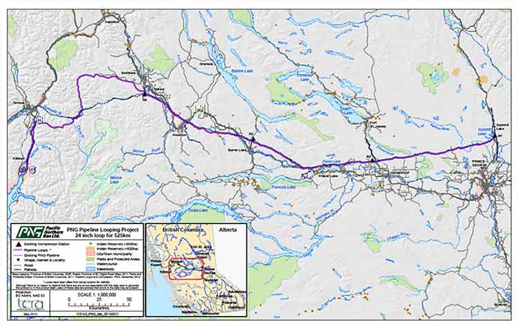
Pacific Northern Gas has filed an application with the BC Environmental Assessment Office to construct and operate an approximately 525 kilometre, 610 millimetre (24 inch) diameter natural gas pipeline from the natural gas hub at Summit Lake, near Prince George, to Kitimat that would loop or twin the existing PNG existing natural gas pipeline.
The application to the BCEAO says: “The proposed Project would supply natural gas to proposed liquefied natural gas (LNG) export facilities as well as the Proponent’s existing customers. The proposed Project would include the replacement of four existing compressor stations and would have an initial capacity of 600 million standard cubic feet per day.”
PNG Pipeline Looping Project Open House at Tamitik. Nov. 26, 2013. (Robin Rowland/Northwest Coast Energy News)
On Tuesday, November 26, Pacific Northern Gas held a sparsely attended open house at Tamitik Arena as part of the BCEAO public comment procedure.
A 38 day public comment period on the application information requirements started on November 25 and will end on January 2, 2014.
At the open house, PNG officials explained that “looping” means that there would be a second or twin pipeline that would mostly be on a parallel route to the existing pipeline. Since both pipelines would begin at the Summit Lake terminal and end at the Kitimat terminal that is where the term “looping” comes in.
The PNG officials said that the pipeline was initially designed to service the first floating LNG terminal at the old log sort site on Douglas Channel south of Kitimat, but north of the KM LNG site at Bish Cove.
It would be operated by BC LNG Energy Cooperative, through Douglas Channel Energy Partnership, a partnership with the Haisla Nation and LNG Partners, the energy investors mainly from Texas,
Unlike the bigger project Kitimat LNG or KM LNG, a partnership between Chevron and Apache (and according to reports possibly Sinopec) or the Shell-led partnership LNG Canada, the BC LNG project would allow smaller companies to provide LNG to Asian customers.
At the open house, the PNG officials said the two pipelines could also service “another Kitimat floating LNG project” but declined to give details for confidentiality reasons. The same officials also said the proponent of that project was also looking at Prince Rupert as a possible site for the second floating terminal.
Kitimat sources have confirmed that AltaGas has told them that the company is also considering Prince Rupert as a site for a floating LNG terminal.
However, the current documentation and maps filed with the BCEAO show the PNG looping pipeline terminating at Kitimat, not Prince Rupert.
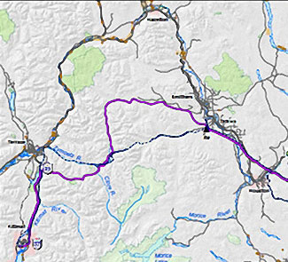
Detail of the PNG Pipeline Looping proposal. The existing pipeline is shown at the dashed line, the new pipeline is shown in purple. (PNG)
According to the maps filed with the BCEAO and made available at the open house, the new pipeline would not be twinned completely along the existing route across the mountains west of Smithers to Terrace, but would head north at Telkwa parallel to Highway 16 before making its own way through the mountains, crossing the existing pipeline at the Zymoetz River east of Terrace and then taking a westerly route toward Lakelese Lake before joining the existing pipeline corridor along Highway 37. AltaGas took over Pacific Northern Gas in the fall of 2011.
The problems currently faced by the Texas group have no affect, at this point, on the Haisla Nation investment in the BC LNG Energy Cooperative. There is already speculation in Kitimat that if the LNG Partners get into further financial difficulty, AltaGas may step in and take over. The would raise the question whether or not there would still be two floating LNG terminals on Douglas Channel, or just the one, as originally planned, but under new ownership.
In it’s project proposal PNG says
The Project will generate approximately 1800-2400 direct person years of employment during construction. Additionally, tax benefits will be generated for Kitimat and the regional districts crossed by the pipeline. PNG anticipates the project will also result in a significant reduction in natural gas transportation rates for its existing customers.
Natural gas transportation costs are a major issue in the northwest, for those costs appear to keep going up while the price of natural gas in North America is generally going down. Natural gas transportation costs in Kitimat spiked after the closure of the Methanex plant and have continued to be quite high, which is just one of the increasing burdens for residents of Kitimat on fixed or low incomes, who are not benefiting as others from the current boom town economy.
The PNG filing with the BCEAO promises consultation with both the Wet’suwet’en Council, and the Office of the Wet’suwet’en, which represents the hereditary chiefs and matriarchs, as well as other First Nations along the proposed route.
PNG Open houses for the project are scheduled for:
Vanderhoof
Friendship Centre Hall
Thursday, November 28, 2013
Terrace
Best Western Inn
Monday, December 2, 2013
Smithers
Hudson Bay Lodge
Tuesday, December 3, 2013
Burns Lake
Chamber of Commerce
Wednesday, December 4, 2013
Summit Lake
Community Hall
Thursday, December 5, 2013
Cullen has issued an open letter to Natural Resources Minister Joe Oliver and Fisheries Minister Gail Shea that says:
21 November 2013
Dear Ministers,
This is an open letter regarding the 21 October 2013 report, entitled Recovery Strategy for the North Pacific Humpback Whale (Megaptera novaeangliae) in Canada, from the Department of Fisheries and Oceans on a recovery strategy for humpback whales in Canada. As you are likely aware, it is part of the DFO’s mandate to help this species recover from a century of whaling that nearly drove the species into extinction. The report identified four areas of “critical habitat” for humpbacks, one of which is at the mouth of the Douglas Channel, the gateway from Kitimat to the Pacific Ocean. The report also identified vessel traffic and toxic spills as two of the greatest threats to the recovery of this species.
Thus, it was with shock and dismay I recently learned of the decision by the federal joint review panel for the Northern Gateway project to ignore the report as evidence in its ruling, as though vessel traffic and the potential for toxic spills were not two of the primary environmental concerns surrounding this proposal.
It is particularly stunning given that the report, submitted to the panel last week, was authored by a federal government agency, and yet the federal government is now saying it refuses to take into account its own information when ruling on this project. It begs the question of why we even have a federal government agency devoted to ensuring the health and viability of our fisheries and our waters when the research and recommendations they produce are ignored by the very same federal government.
The purpose of the joint review panel hearings is to weigh the available scientific evidence in determining whether this project will negatively impact habitat and endangered species. The purpose of the work of the DFO is to ensure that information is considered when the government is weighing projects which will impact habitat and endangered species. The decision by the JRP to ignore the DFO report is not only wasteful indifference; it’s a double-play failure and abrogation of the duty of both of your departments to protect endangered species and our natural environment.
I wish I could feign some measure of surprise on this matter. But like many Canadians, I have come to see this kind of negligence as not only a passing tendency of the Conservative government but as a very intentional aspect of the government’s resource and environmental policy.
When the government of Canada ignores its own science on endangered species protection, it’s no wonder why Canada has lost all credibility on environmental stewardship among both its own citizens and the international community.
A poll released this morning by Insights West, and already being heavily promoted by Enbridge Northern Gateway claims to show: “Opposition to the proposed Enbridge Northern Gateway Pipelines has subsided over the past 10 months in British Columbia, with the province’s residents now being staunchly divided on the project…”
It goes on to report:
In the online survey of a representative sample of British Columbians, support for the proposed Northern Gateway Pipelines stands at 42%, a seven-point increase since an Insights West poll conducted in February. Conversely, opposition to the project has dropped by 14 points, from 61% at the start of 2013 to 47% today.
It is important to note that the level of “strong opposition” to the project has fallen to 29% (down 9 points since February), while “strong support” increased to 16% (+5).
What the press release doesn’t tell you is that opposition to the Northern Gateway, according to the poll, is at 65 per cent in Northern British Columbia, with 50 per cent strongly opposed and 15 per cent somewhat opposed.
The Insight Poll assumes the findings of the online poll are within the usual margin of error
We have assumed that the same margins of error apply as if it were a true unweighted random probability sample with a margin of error of +/- 3.7 percentage points, nineteen times out of twenty.
The problem with the Insight West poll, like all other polls on the Northern Gateway, is that it is weighted toward the population heavy Lower Mainland. The tables released by Insight West show that the online poll had 504 respondents in Vancouver and 25 in Northern BC.
Northwest Coast Energy has spoken to pollsters both on the record and on background and it is clear that the polling entire province distorts the issue along the pipeline route.
The problems with these polls are two fold:
First is the standard polling definition of Northern British Columbia, which is based on Census data. “Northern BC” actually begins at Williams Lake, although most people believe Northern BC begins around Prince George.
Second the polls, due to small population and sample size, do not usually divide northwestern British Columbia, where the opposition is strongest to the Northern Gateway project, and northeastern British Columbia, where the energy industry is a major employer and support for the project is likely stronger.
The tables released by Insight West shows that poll surveyed just 25 people in “Northern British Columbia” but 504 in “Metro Vancouver.”
In a 2012 Ipsos Reid poll conducted on behalf of Enbridge, public affairs spokesperson Kyle Braid said their survey covered 168 people in “Northern British Columbia.” As Northwest Coast Energy News reported at the time:
Braid says the 168 people represents 17% of the sample. These interviews would have been weighted down to about 7% in the overall results to reflect the actual population of the North in BC. The margin of error in the North is about +/-7.6%, 19 times out of 20.
So with a total sample of 749 in the Insight West online poll and just 25 people in Northern BC surveyed, that means the Insight West poll survey of Northern BC covers just 3.3 per cent of the total sample. In contrast, 504 people in Vancouver were surveyed, accounting for 67.2 per cent of the sample.
The Insight West survey does acknowledge that:
British Columbians continue to be of two minds on the Northern Gateway,” continues Canseco. “There is a large proportion of the population that remains concerned with the possibility of oil spills and environmental problems, but the argument about economic benefits has gained traction over the past few months.
The actual tables show that of the 25 people surveyed in Northern BC, 50 per cent “strongly oppose,” (13 out of the 25 people surveyed) 15 per cent “somewhat oppose” Northern Gateway. Twelve per cent “somewhat support” the project, four per cent (one person) “strongly support” the project.
Those numbers, although small, are likely an accurate reflection of the sentiments in northern BC, although a breakdown between the western and eastern parts of Northern BC would have been helpful.
As for the residents of Vancouver, the poll shows that area is divided (as the Insight West news release says) with 22 per cent strongly supporting (119 people) and 27 per cent somewhat supporting the project and 19 per cent somewhat opposed and 27 per cent strongly opposed (123 people).
The “growing support” for the pipeline project that Enbridge is promoting from the poll likely shows that their advertising campaign is having some impact on the Lower Mainland but is ineffective in the north.
It is possible to do more accurate polling on energy issues in Northern British Columbia. Earlier this year, a significant number of Kitimat residents reported that they had received calls from a polling company representing TransCanada which will be building the Coastal GasLink pipeline project for LNG Canada, a project where Shell will operate the terminal in Kitimat.
On Monday, when TransCanada officials appeared before District of Kitimat council, they did acknowledge that they have been polling people along the pipeline route so they can understand their concerns. So far, TransCanada has not released the results of that poll.
The Northern Gateway Joint Review Panel has refused to consider the latest findings from the Department of Fisheries and Ocean on humpback whale critical habitat on the coast of British Columbia, including areas of ocean that could be on the route of tankers carrying diluted bitumen from Kitimat.
On October 21, 2013, Fisheries and Oceans released a report called Recovery Strategy for the North Pacific Humpback Whale (Megaptera novaeangliae) in Canada. The DFO report notes that humpback whales are a species of “special concern” by the Committee on the Status of Endangered Wildlife in Canada.
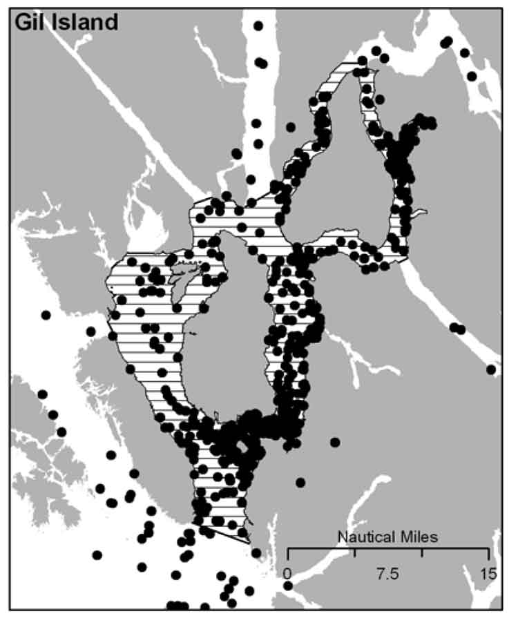
It is DFO policy to assist the humpback whale population to recover from the century of whaling that almost drove the species to extinction. The report identified four areas of “critical habitat” for humpbacks. One critical habitat zone is Gil Island at the mouth of Douglas Channel.
DFO map of humpback sightings on the BC coast. (DFO)
Last week, on November 13, Smithers based environmental activist Josette Weir filed a notice of motion with the JRP requesting that the panel consider the DFO report as late evidence.
Weir acknowledged that the JRP proceedings closed on June 24, after final arguments in Terrace, but she noted that rules allow the Board to override the final closure. She argued that the humpback report fell within the JRP’s mandate since the DFO report is “is likely to assist the Panel.”
Weir noted in her motion that there was insufficient information before the JRP that would identify critical humpback habitat.
She argued:
Three of the four critical known habitats are on the proposed tanker routes, and the Recovery Strategy acknowledges that other areas have not been identified. Without such information, it is impossible to assess the potential effects of the marine transport of bitumen on this endangered species.Activities likely to destroy or degrade critical habitat include vessel traffic, toxic spills, overfishing, seismic exploration, sonar and pile driving (i.e., activities that cause acoustic disturbance at levels that may affect foraging or communication, or result in the displacement of whales).
The report clearly identifies vessel traffic and toxic spills, which are associated with the Project as potential causes for destruction or degradation of the Humpback Whales’ critical habitat.
Weir went on to argue that the JRP had “insufficient information to develop relevant protection measures” because the humpback studies are ongoing, “meaning their results will not be available before decision.”
The Panel must consider this significant risk to an endangered listed species for which no meaningful protection measure can be offered against the risks associated with the Project.
Weir also noted that “No similar submission has been made by others, but I cannot predict if others will not see fit to do so.”
The JRP didn’t take long to reject Weir’s request, replying the next day, November 14.
In its response, the JRP cited the amended Joint Review Panel Agreement, signed after the passage of of the Jobs, Growth and Long-term Prosperity Act, the Omnibus Bill C-38, that “provides that the Panel’s recommendation report is to be submitted to the Minister of Natural Resources by 31 December 2013.”
The JRP then told Weir it didn’t have jurisdiction over endangered species (even if those species inhabit the tanker route) saying:
The Panel notes that the Recovery Strategy has been released in accordance with the provisions of the Species At Risk Act, as part of a legislative scheme that operates independently of this joint review process.
It goes on to say: “In this case, the Panel also notes that the Recovery Strategy was not authored by or for Ms. Wier.”
Humpback whale sightings at the Gil Island critical habitat. (DFO)
The executive summary of the DFO report noted:
Critical habitat for Humpback Whales in B.C. has been identified to the extent possible, based on the best available information. At present, there is insufficient information to identify other areas of critical habitat or to provide further details on the features and attributes present within the boundaries of identified critical habitat. Activities likely to destroy or degrade critical habitat include vessel traffic, toxic spills, overfishing, seismic exploration, sonar and pile driving (i.e., activities that cause acoustic disturbance at levels that may affect foraging or
communication, or result in the displacement of whales). A schedule of studies has been included to address uncertainties and provide further details on the critical habitat feature(s), as well as identify additional areas of critical habitat. It is anticipated that results from these studies will also assist in development of relevant protection measures for the critical habitat feature(s).
In the part of the report on the danger of toxic spills to humpbacks, the DFO report mentions that sinking of the BC ferry Queen of the North:
Toxic spills have occurred impacting marine habitat along the B.C. coast. For example, the Nestucca oil spill (1988) resulted in 875 tonnes of oil spilled in Gray’s Harbor, Washington. Oil slicks from this spill drifted into Canadian waters, including Humpback Whale habitat. In 2006, a tanker ruptured in Howe Sound, B.C. spilling approximately 50 tonnes of bunker fuel into coastal waters. In 2007, a barge carrying vehicles and forestry equipment sank near the Robson Bight-Michael Bigg Ecological Reserve within the critical habitat for Northern Resident Killer Whales, spilling an estimated 200 litres of fuel. The barge and equipment (including a 10,000L
diesel tank) were recovered without incident. When the Queen of the North sank on March 22, 2006, with 225,000 L of diesel fuel, 15,000 L of light oil, 3,200 L of hydraulic fluid, and 3,200 of stern tube oil, it did so on the tanker route to Kitimat, which is currently the subject of a pipeline and port proposal and within the current boundaries of Humpback Whale critical habitat
The DFO report also takes a crtical look at vessel strikes
In B.C. waters, Humpback Whales are the most common species of cetacean struck by vessels, as reported to the Marine Mammal Response Network. Between 2001 and 2008, there were 21 reports of vessel strikes involving Humpback Whales. Of these, 15 were witnessed collision events while the remaining 6 were of live individuals documented with fresh injuries consistent with recent blunt force trauma or propeller lacerations from a vessel strike.
Overall, vessel strikes can cause injuries ranging from scarring to direct mortality of individual whales. Some stranded Humpback Whales that showed no obvious external trauma, have been shown from necropsy to have internal injuries consistent with vessel strikes… It is unknown how many whales have died as a result of vessel strikes in B.C. waters. To date, only one reported dead Humpback Whale presented with evidence consistent with blunt force trauma and lacerations resulting from a vessel strike…
There are no confirmed reports of Humpback Whale collisions in B.C. waters attributed to shipping, cruise ship or ferry traffic. However, larger ships are far less likely to detect the physical impact of a collision than smaller vessels, and this could account for the lack of reported strikes. Collisions with large vessels may be more common than reported, especially in areas where larger vessel traffic is concentrated.
Despite the fact that collisions may only affect a small proportion of the overall Humpback Whale population, vessel strikes may be a cause for concern for some local and seasonal areas of high ship traffic.. In B.C., areas of high probability of humpback-vessel interaction include Johnstone Strait off northeast Vancouver Island, Juan de Fuca Strait off southwest Vancouver Island, Dixon Entrance and the “Inside Passage” off the northern B.C. mainland which include portions of two of the identified critical habitat areas..
The JRP also said
As the Panel has mentioned previously during the hearing, the later in the joint review process that new evidence is sought to be filed the greater the likelihood of the prejudice to parties. The Panel is of the view that permitting the Recovery Strategy to be filed at this late stage in the hearing process would be prejudicial to the joint review process.
Protesters march down Kingfisher Ave, during the Defend Our Coast Rally in Kitimat, Nov. 16, 2013. (Robin Rowland/Northwest Coast Energy News)
About 250 people took part in the Defend Our Coast Rally at Mount Elizabeth Secondary School, Saturday, Nov. 16, 2013. The Kitimat protest was part of what organizers said were 130 rallies across Canada to protest environmentally threatening energy developments including the Alberta bitumen sands and various pipeline projects under the labels of Defend Our Climate or Defend Our Coast.
Gerald Amos addresses the rally. (Robin Rowland/Northwest Coast Energy News)Kelly Marsh speaks about his studies that show small or mid-level pipeline breaches are inevitable. (Robin Rowland/Northwest Coast Energy News)Family at the rally. (Robin Rowland/Northwest Coast Energy News)Patricia Lange addresses the rally. (Robin Rowland/Northwest Coast Energy News)Protesters join arms, a feature of every one of the rallies across Canada. (Robin Rowland/Northwest Coast Energy News)The protest march on Kingfisher. (Robin Rowland/Northwest Coast Energy News)The protest march. (Robin Rowland/Northwest Coast Energy News)
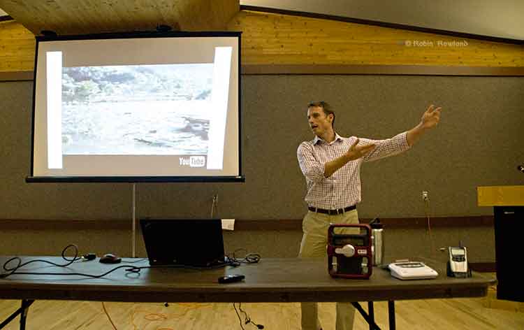
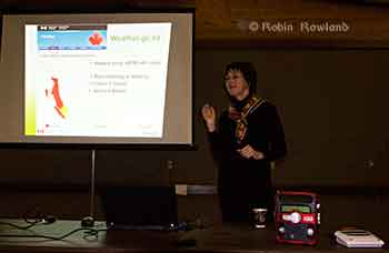
Teron Moore of Emergency Management explains a surge tsunami at a emergency preparedness forum at Riverlodge, Nov. 4, 2013 (Robin Rowland/Northwest Coast Energy News)
The District of Kitimat plans to issue a tsunami hazard and evacuation map for the town.
Fire Chief Trent Bossance and Emergency Coordinator Bob McLeod told a forum on emergency preparedness on November 4 that the map is in the final stages of preparation and will be distributed to residents in the near future.
The forum was also told that the former District Council Chambers on the second floor of the public safety building (the fire hall) is being converted into “a fixed, permanent emergency operations centre,” with upgraded communications and computer equipment.
McLeod said that over the past months, since the October 27, 2012 Haida Gwaii earthquake and the January 31, 2013, Sitka, Alaska earthquake, Kitimat’s emergency planners have been working with the province to update the original emergency plan which was first developed about 12 years ago.
McLeod said that the plan was recently sent to a consultant who told Kitimat the overall plan only needed minor charges. Now, however, there is new emphasis on tsunami planning.
Fire Chief Bossance says emergency planners have been consulting with scientists who have concluded that if a tsunami was to come into Kitimat from Douglas Channel, it most likely would be between two and four metres, so to be on the safe side, the District is planning on a “six metre baseline” from the high tide line. That means the hazard map will be based on the possibility of a six metre tsunami coming up the Channel. ( A worst case scenario, however, could result in a bigger tsunami, perhaps eight metres).
The forum at Riverlodge was part of an effort by both federal and provincial officials to visit communities that were affected by the two recent major earthquakes, inform local residents of updated planning by the federal government and British Columbia and to let those officials know what local concerns are.
Anne McCarthy of Environment Canada explains that tsunami warnings on the Environment Canada website will be similar to weather warnings. Weather radios can be seen on the table in the foreground. (Robin Rowland/Northwest Coast Energy News)
Anne McCarthy of Environment Canada says her agency is planning to expand the Weather Radio system, most popular in Tornado Alley in the United States, to the northwest coast. There are already Weather Radio transmitters in the Lower Mainland. Kitimat, however, at this point, is low on the priority list, with Prince Rupert and then Sandspit and Masset roll outs in the coming year.
Environment Canada also plans to implement a Twitter feed sometime in 2014, that would supplement other Twitter feeds from Emergency Planning BC and the recently renamed US National Tsunami Warning Center (formerly the Alaska and West Coast Tsunami Warning Center), operated by the US National Oceanic and Atmospheric Administration. Tsunami warnings will also be posted on the Environment Canada website in the same way weather and other alerts are posted.
Surge of water
If an earthquake-triggered tsunami was to strike Kitimat from Douglas Channel, it would not be the big waves seen in the movies and during the 2004 Southeast Asia tsunamis, Teron Moore, a seismic specialist with the BC Provincial Emergency Management said. Given the configuration of Douglas Channel and its many islands, a tsunami is more likely to be a “surge” of water.
“Tsunamis can appear like a rising tide that quickly keeps coming in, “ Moore said. “A normal tide would stop at the high tide line.Sometimes a tsunami can be a quickly rising tide that keeps on coming….A wave can come in for 30 minutes. it’s a long, long time that these waves just keep on coming in and you wouldn’t see the crest of a wave, necessarily and then they come out. So it’s almost like that river comes in for half an hour and then can go back out for half an hour. There’s a tendency for people first of all to not think it’s dangerous, A second, third and fourth wave can come in.”
Tsunami events can last as much as eight to twelve hours, Moore said. Depending on the location of the triggering earthquake, Kitimat is likely to have some warning of a possible incoming earthquake-triggered tsunami.
The second type of tsunami could be triggered by a submarine landslide in Douglas Channel, as happened with slope failures in October 17, 1974 (triggering a 2.4 metre tsunami at low tide) and on April 27, 1975 (generating an 8.2 metre tsunami). The 1975 tsunami destroyed the Northland Navigation dock near Kitimat and damaged the Haisla First Nation docks at Kitamaat Village.
“The slide in 1975 generated an eight metre wave that came from Moon Bay across to Kitimat Village, now that is huge wave. We can’t really predict an event like that, it would happen so fast,” McLeod said.
Hazard areas
Two major fault lines could trigger shaking in Kitimat and might possibly also mean that there could be a tsunami.
The first is the Cascadia fault which goes from the northern California to the western edge of Vancouver Island. The second is the Queen Charlotte fault off Haida Gwaii.
The Cascadia fault, Moore said, is an active subduction zone. “A subduction zone is where two of earth’s large plates are colliding against each other and one of those plates is going under neath another one of those plates.’ The plates get stuck and build up strain “almost like pulling an elastic band. At sometime the elastic band snaps creating a very large earthquake,” Moore said.
The Juan de Fuca plate is a very large plate subducting underneath the continent of North American plate. The Juan de Fuca plate has been stuck for some 300 hundred years since the last time it ruptured. There is a rupture about every 500 years or so in this zone that triggers a large earthquake.
“But, Moore warned, “it’s 500 years plus or minus 200 years. even though there’s a lot of modelling doing on, there’s still a lot of uncertainty and so its a concept that it is difficult to get an understanding of.
“The Haida Gwaii or Queen Charlotte fault….is one that is going side by side. It’s called a strike slip fault. “A strike slip fault can still cause earthquakes it can still rupture and cause shaking, but if it doesn’t have that subduction, you tend to not have tsunamis. “Although science says the Charlotte fault has a low likely of causing a tsunami, but as we know from last year the Charlotte fault did cause a tsunami, quite a significant tsunami in some areas, not one that impacted Kitimat but one that could have impacted Kitimat and did impact, the west coast of Haida Gwaii quite significantly.
“We were very lucky there weren’t any large communities out there. We very lucky that it wasn’t at the height of summer tourist season with kayakers and fishing lodges. In some areas, the way the wave came into certain bays, created a five metre tsunami. “So if you were on the beach and a five metre tsunami was coming up the inlet, that’s a significant tsunami. What I want to emphasize is that people here who felt the shaking, they should have gone to high ground.”
Emergency procedures
In the case of a major earthquake, where residents of Kitimat feel shaking, then they should take appropriate precautions, the forum was told, including moving to higher ground if they think they should.
“Once the maps are available we will get them out to the public. I think it is important for the public to understand and visualize, where they sit within that six metre height. Always if you’re unsure go to higher ground. It’s easier to come back if your house is unaffected, than trying to leave if your house is being affected,” McLeod said.
There would be no reason to actually leave Kitimat, according to Emergency Management B.C.’s northwest regional manager Maurie Hurst. “Kitamaat Village should evacuate to higher ground. I would not like to see them coming down that coast highway to Kitimat, that’s not safe. Stay where you are, move to higher ground.
“At Sandspit higher ground is quite a ways a way from the community for them they are having to a bit of travel but in Kitimat higher ground is a ten minute walk, a five minute drive, it’s right here within the community.”
After an earthquake occurs, the National Tsunami Warning Center in Homer, Alaska evaluates the situation and sends out alerts to Canadian and US government agencies. In British Columbia, Emergency Management BC is the lead agency.
It communicates with Environment Canada, the Canadian Coast Guard, local emergency officials and the media. In Kitimat, it is the local emergency management officials and first responders who are in charge.
After misinformation went out over social media during the October 27, 2012 event, McLeod says the District of Kitimat now has social media specialists at the Emergency Operations Centre. “We’ve modified the district website, so there will be banners going up on it, just to get accurate information out.” Using the baseline of six metres above high tide, McLeod says the Rio Tinto Alcan wharfs, MK Bay Marina and the Kitamaat Village dock would most likely be affected.
While that means most of the Kitimat community may not be affected, there are other factors involved, according to Chief Bossance. “Because of all the islands we have in the waterways, we’re not going to have that big wave, we are going to have that surge,” he said. “If a tsunami is coming, we always look at the earthquake, what was its magnitude, obviously the higher the magnitude, the more impact it’s going to have for everyone in that case.
Kitimat Fire Chief Trent Bossance explains emergency procedures in case of a tsunami (Robin Rowland/Northwest Coast Energy News)
“We looked at seven point seven the most recent one, (on Haida Gwaii)it had very little impact here due the fact that it was a slip slide.
“The other fault, the one along Vancouver Island, is a different fault altogether. The problem we’re having with us right now, there haven’t been a lot studies conducted with how that waters going to impact coming from that direction into us.
“If it’s a significant shaking, don’t wait for us to tell you to go high ground.
“So they’re saying anywhere from two metres, depending on high tide up to four. We took the next step and said we’re going to go with six to build in a safety factor.
“But saying that, we have to know what our tide heights are at the time the tsunami strikes. The other thing we look at is the magnitude of the quake.
“So if you’re living down in the Kildala area and if we determine that it’s an eight metre event, then evacuation might be necessary.
“Everything is do dependent on what happens from the time of the earthquake, the tides, the weather. If we’re having significant rainfall at the time, that would mean the river would swell. If it’s the fall when we get our monsoons, that may change the fact of what’s going to happen.
“If you look at the dike, the dike is what is separating us from the river. Kitimat is sort of odd in that we have a dike that surrounds a lot of the town, but there’s an open spot in it, so it’s going to funnel through there and into the lower lying areas of the Kildala area.”
Under most circumstances, Bossance said, the City Centre Lower Parking lot would be above the danger zone.
“Just because we’re looking at six doesn’t mean it’s not going affect everyone, our plan is constantly evolving. Local officials are the ones to tell you it is safe to go back home.”
Boaters concerned
There was one question arose at the forum that the panelists had no immediate answer for. What should boaters do if there is a tsunami warning while they are on the Channel, especially during the summer or the peak salmon season when there could a hundred or so boats on the water?
“Douglas Channel is a deep channel,” Bossance said. “It’s in the shallow water and it builds, but here it is relativey deep water until it’s close to shore. That’s why it’s such a great deep sea port,its deep and then it shallows fairly quickly that’s why they’re saying we’re not going to have that big wave coming in., its going to be a surge of water.”
The panel they would investigate the situation further but at the moment they presume that it would be best to go the center of the channel. “The usually advice to make for open water that’s what the [US] coast guard recommends.”
A similar brochure from Hawaii recommends a minimum depth of 300 feet and staying clear of a harbour entrance channel during an event. The Hawaii brochure warns that if a boater is not on the water, they should not go down to their boats.
The brochure notes that: “In 1964 in Kodiak, Alaska, a warning was received prior to the arrival of the first tsunami waves. People who rushed down to the harbor to secure or take their boats out to sea constituted two thirds of all the fatalities caused by the tsunami at Kodiak City.” There is, so far, no similar brochure issued by the province of BC.
The panel suggested that a sign be posted at MK Bay, outlining safety procedures. Moore said: “The other thing we’re thinking about is there could be wave action for eight to ten to twelve hours maybe. If you need to have eight to ten hours of gas to fight the current, eight to ten hours of food, all the things you’re going to need. There were cases in California where boats kept on idle to keep being driven into shore and then they run out of gas, and then they ended up in dangerous situations. Each individual has to assess how big is their boat and where it is in the water and how it’s going to come in.
“For me I would rather be on shore if I could get to shore quick enough and get to higher ground but if you’re closer to the ocean and you have a big vessel and have the gasoline for 10 hours, then may be you’re better off.”
The Hawaii brochure also warns that watches and warnings for mariners on VHF Channel 16 (the calling and emergency channel) may be different for those on land. Hurst noted that some people in Haida Gwaii were picking up US Coast Guard advisories on VHF 16 which said the October tsunami warning had been downgraded. While the warning was downgraded for Alaska, the warnings continued for Haida Gwaii.
Hurst said those monitoring Channel 16 must be be sure they are monitoring the advisories on 16 from Prince Rupert Coast Guard Radio.
Another problem, given the configuration of Douglas Channel, is that if a tsunami severely damages MK Bay, Minette Bay, the Village Dock, the RTA docks and Nechako dock, there may be no place for boaters to return to safely given the rocky shore of Douglas Channel, which is quite different than coasts of California or Hawaii where boating is part of the emergency planning.
“The Kitimat emergency plan will have to take into consideration boaters on the water, it’s not necessarily covered by legislation but if the plan exists, they can get it out to citizens who are out on the water,” Hurst said
Preparation
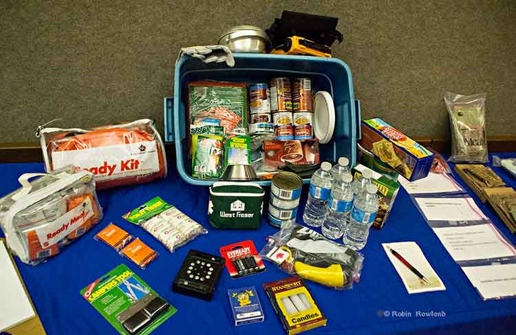
A 72-hour emergency kit was on display at Riverlodge. It includes the civilian version of military meals ready to eat as well as both dried and canned food, water, a first aid kit and other supplies. (Robin Rowland/Northwest Coast Energy News)
“From an earthquake perspective,” McLeod said, “folks should be looking at their own home preparation, making sure your residence is as earthquake proof as you could possibly make it by anchoring things to the wall, by making every effort that things are not going to fall on you. Every October there’s going to be a shakeout, which gives all an opportunity to get under the table and practice, drop, cover and hold on.
“So know the hazards, have a plan, have an emergency kit. You rotate the products in it on say an annual basis, hopefully you never have to touch it, but it’s there if you definitely need it. The emergency kit should have supplies for both humans and pets for a minimum of 72 hours.
Planning should also take in to consideration that even if there isn’t major damage in Kitimat, due emergencies in other parts of the province, the town could be cut off for several days, resulting in shortages.
Skeena Bulkley Valley MP and NDP House leader is calling today’s framework deal between BC Premier Christy Clark and Alberta premier Alison Redford, “a bust hand.”
In a statement released late Tuesday, Cullen said:
MP Nathan Cullen called the BC-Alberta framework agreement struck this morning regarding Enbridge “political window-dressing” that draws a blind on truth and transparency and deals a bust hand to British Columbia.
“When it comes to the Enbridge Northern Gateway Pipeline, everything is negotiable for Christy Clark, including principals and promises made leading up to last May’s provincial election,” Cullen said.
“The reality is that none of the five conditions Ms. Clark made such a big deal about 16 months as being necessary for Enbridge to put a pipeline through our province were even remotely addressed in today’s announcement.
“The best we got after overnight negotiations and months of high drama is the ‘possibility of progress’ and a bizarre blessing that somehow allows BC to negotiate directly with Enbridge.
“Today’s agreement does absolutely zero to protect BC’s environment and economy from a bitumen disaster,” Cullen said.
“It’s a shameful political ploy that greases Ms. Clark’s real agenda, which is to pump oil through BC regardless of environmental or economic costs.
“Six months into a new mandate and Premier Clark has turned her back on promises to stand up for BC and demand a higher standard from industry.”
Cullen noted Enbridge’s social licence to operate is clearly tied to safe oil transport, effective spill response, and First Nations consent, conditions on which today’s agreement is silent.
Cullen vowed to continue fighting the Enbridge pipeline and to work toward sustainable resource development that is supported by Skeena-Bulkley Valley communities.
Haisla Nation Chief Counsellor Ellis Ross at Bish Cove, June 19, 2013. (Robin Rowland/Northwest Coast Energy News)
In 2003 I was first elected to Haisla Nation Council, and I was intent on opposing just about every economic development project coming our way, from fish farms to natural gas. Fortunately experienced councilors suggested that before I took any hard and fast positions that I consider unbiased facts and the community’s social situation.
It didn’t take long before the full extent of our community’s problems hit home, angering and saddening me at the same time. Before my political career I was one of those who applauded political speeches on unemployment, poverty, independence, and the relationship between First Nations and the Crown. But it was now clear that 30 years of speeches and government programs had changed nothing for the average Haisla person who just wanted a job. Unemployment was still at 60 per cent, housing was based on hand-outs from Ottawa, and, worst of all, substance abuse and suicides were commonplace and were destroying our people’s hopes for a brighter future.
I was fortunate to have found work outside of my reserve for most of my adult life but there are only so many jobs in depressed economies and the long term jobs were kept out of our reach by organizations associated with the corporations set up in our territory. The result was our young men and women either had to leave home for employment or stay home and accept seasonal work (UIC) or welfare. Leaving ancestral homes is a hard decision for First Nations to make. The land is connected to our protocols, our culture and to our past.
Many reasons have contributed to the demise of our peoples and communities but perhaps the foremost is the culture of dependence. Dependance in our case was from the top down; from council dependant on government funding to the individual band member being dependant on council or welfare. Our people are not lazy. The culture that preceded the non haisla culture was one of hard work to bring in food, resources and wealth. That culture has not merged so well with non haisla culture but our work ethic is the same as the non haisla culture.
If poverty is the only lifestyle you know, it is very difficult to know there is a way out, much less thinking of a way to get out of it. The individual band member that is watching development in their territory and watching the wealth being generated without having an opportunity to be a part of it is going to have resentment.
Those Nations which are succeeding — strong employment levels, healthy communities, few social ills — appear to have gained a level of independence and have done it mostly through economic development. The newer discussions are those concerning shiftwork, double time, new bosses and how paychecks will go towards the next hunting trip or holidays to vancouver or elsewhere.
We have many proposals put in front of us now that we have to sift through. When we look at these proposals we have to find accurate information in terms of impacts, benefits and feasibility. Sub topics can be right of ways, fracking, logging practices, financing, permitting, corporate structures, emissions, land ownership and the list goes on and on. We do have to consider the future but we also have to consider the present and the situation we know that our membership is in and try to put them in a position where they can help themselves.
So far, the outlook has been positive. Our people have jobs. They have hope. They are confident about their futures. The despair that comes with poverty is slowly disappearing but we have more work to do to ensure their confidence can be sustained. We know that to become a strong independent Nation, we need to have strong independent members.
We will continue to look at the contentious issues that are in front of us and will try as much as we can to resolve with both the crown and the proponent but we cant lose sight of one of the biggest reasons of why we’re doing what we do. Our members need a future.
By the way, the work we have done to date has not only assisted our members but has assisted the region and non Haislas in ways that we have not yet even started to measure yet.
Ross.
Ross later posed two comments:
Ellis Ross: got some good feedback on this but also got feedback that it was unclear on the point I was trying to make so I rewrote it. the point was in light of all the issues we have to look at, we can’t lose sight of the social factor in that some Haislas (and non Haislas) deserve the employment/contract opportunity that comes with proposed projects.
Ellis Ross: fracking, emissions, land ownership, etc… are issues that are extremely important but our people living in poverty with no hope is also an extremely important issue.
VANCOUVER – After officials worked through the night, Alberta Premier Alison Redford and British Columbia Premier Christy Clark today announced a framework agreement between the two provinces on moving energy resources to new markets.
“Agreement on B.C.’s 5 conditions is a necessary first step before any proposals can be considered for approval,” said Premier Christy Clark. “It is the way we do business in B.C. and it works. By working together with Alberta through these principles we can grow our economies, and strengthen Canada’s economy overall.”
The framework will also see the Government of British Columbia endorse Premier Redford’s Canadian Energy Strategy.
“A key part of our Building Alberta Plan is getting Alberta’s resources to new markets at much fairer prices so we can keep funding the programs Albertans told us matter most to them,” said Premier Alison Redford. “Today’s agreement with B.C. is good news for Alberta, for British Columbia and for all Canadians. I welcome Premier Clark’s endorsement of the Canadian Energy Strategy and our shared commitment to create jobs, long-term growth and position Canada as a true global energy superpower. We look forward to continued constructive dialogue with B.C.”
The governments of B.C. and Alberta agree that British Columbia’s conditions are intended to ensure both the responsible production of energy as well as its safe transport to new markets, giving projects the social licence to proceed.
B.C.’s conditions 1-4 are designed to achieve both economic benefit and risk mitigation on increased shipments through B.C. They mirror Alberta’s legislated commitments on responsible energy production. Alberta and B.C. agree that only through intensive environmental review and protection, enhanced marine safeguards and First Nations support, can projects proceed.
On condition five, Alberta agrees that B.C. has a right to negotiate with industry on appropriate economic benefits. Both governments agree it is not for the governments of Alberta and B.C. to negotiate these benefits. Both provinces reaffirmed that Alberta’s royalties are not on the table for negotiation.