TransCanada plans rugged over-mountain route for gas pipeline to Kitimat


Coastal GasLink map
A map from TransCanada’s Coastal GasLink showing the conceptual route of the proposed natural gas pipeline from the shale gas fields in northeastern BC through the mountains to Kitimat and the proposed Shell LNG facility. (TransCanada)

TransCanada plans a rugged over-mountain route for its proposed Coastal Gaslink pipeline to the Shell Canada liquified natural gas project in Kitimat, BC, company officials said Monday, Oct. 15, 2012, in two presentations, one to District of Kitimat Council and a second at a community town hall briefing.

The pipeline would initially carry 1.7 billion cubic feet of natural gas per day from the Montney Formation region of northeastern British Columbia along a 48 inch (1.2 metre) diameter pipe over 700 kilometres from Groundbirch, near Dawson Creek, to Kitimat, site of the proposed Shell Canada LNG Canada project.

Rick Gateman, President of Coastal GasLink Project, a wholly owned TransCanada subsidiary told council that the project is now at a “conceptual route” stage because TransCanada can’t proceed to actual planning until it has done more detailed survey work and community consultations.

At the same council meeting, documents from Shell Canada notified the District that it has formally applied to the National Energy Board for an export licence for the natural gas.

Rick Gateman
Rick Gateman, president of TransCanada’s Coastal GasLink addresses District of Kitimat Council, Oct. 15, 2012. (Robin Rowland)

Gateman told council that since the pipeline itself will be completely within the province of British Columbia, it comes under the jurisdiction of the British Columbia Environmental Assessment process and the BC Oil and Gas Commission and that the NEB will not be involved in approving the pipeline itself.

At first, the Coastal Gas Link pipeline would be connected to the existing Nova Gas Transmission system now used (and being expanded) in northeastern British Columbia.

From Vanderhoof, BC to west of Burns Lake, the Coastal GasLink pipeline would be somewhat adjacent to existing pipelines and the route of the proposed Enbridge Northern Gateway bitumen pipeline and the proposed Pacific Trails natural gas pipeline.

Somewhat south of Houston, however, the pipeline takes a different route from the either the Northern Gateway or Pacific Trails Pipeline, going southwest, avoiding the controversial Mount Nimbus route.

Howard Backus, an engineering manager with TransCanada told council that the route changes so that Coastal GasLink can avoid “congestion” in the rugged mountain region.

Backus said that the Pacific Trails Pipeline for Apache and its partners in the Kitimat LNG project “is skirting” Nimbus while Enbridge plans to tunnel through the mountain. That tunnel is one of the most controversial aspects to the Northern Gateway project. The local environmental group Douglas Channel Watch has repeatedly warned of the dangers of avalanche and geological instability in the area where the Northern Gateway pipeline emerges from the tunnel. Enbridge has challenged Douglas Channel Watch’s conclusions in papers filed with the Northern Gateway Joint Review panel.

Under TransCanada’s conceptual route, the pipeline heads southwest and then climbs into the mountains, crossing what Backus calls “a saddle” (not a pass) near the headwaters of the Kitimat River. The pipeline then comes down paralleling Hircsh Creek, emerging close to town, crossing the Kitimat River and terminating at the old Methanex plant where Shell plans its liquified natural gas plant. (That means that if the conceptual plans go ahead, the TransCanada pipeline would climb into the mountains, while Pacific Trails finds a way around and Enbridge tunnels).

Backus told council that going north “created more issues,” but did not elaborate.

Backus assured people at the town hall that energy companies have a lot of experience in building pipelines in mountainous areas, including the Andes in South America.

Asked by a local businessman at the town hall if it was possible to build a road along the route of the pipeline, Backus said the mountain areas would be too steep.  Any pipeline maintenance would have to be done by tracked vehicle, he said.

Gateman told council that the pipeline would be buried along its entire route. If Shell increases the capacity of its LNG facility in Kitimat, the Coastal Gaslink pipeline could increase to 3.4 billion cubic feet a day or perhaps even more. For the initial capacity, the company will have one compressor station at the eastern end of the line. If capacity increases or if the route requires it, there could be as many as five additional compressor stations. (TransCanada’s long term planning is based on the idea that Shell will soon be adding natural gas from the rich Horn River Formation also in northeastern BC to the Kitimat export terminal.)

TransCanada will begin its field work, including route and environmental planning and “community engagement” in 2013 and file for regulatory approval in 2014. Once the project is approved, construction would begin in 2015.

Gateman said that TransCanada is consulting landowners along the proposed right of way and “on a wide area on either side.” The company also is consulting 30 First Nations along the proposed route. Gateman told council, “We probably have the most experience of any number of companies in working directly with and engaging directly with First Nations because of our pipelines across Canada.”

(Despite Gateman’s statement, the TransCanada maps showed that the Coastal Gaslink Pipeline would cross Wet’suwet’en traditional territory and officials seemed to be unaware of the ongoing problems between Apache and the Pacific Trails Pipeline and some Wet’suwet’en Houses who oppose that pipeline).

Gateman told council that the pipeline would be designed to last at least 60 years. He said that in the final test stages, the pipeline would be pressured “beyond capacity” using water rather than natural gas to try and find if any leaks developed during construction.

He said that the company would restore land disrupted by the construction of the pipeline, but noted that it would only restore “low-level vegetation.” Trees are not permitted too close to the pipeline for safety reasons.

TransCanada made the usual promises the region has heard from other companies of jobs, opportunities for local business and wide consultations. (TransCanada may have learned lessons from the botched public relations by the Enbridge Northern Gateway. A number of Kitimat residents have told Northwest Coast Energy News that TransCanada was polling in the region in mid-summer, with callers asking many specific questions about environment and the spinoffs for communities).

Councillor Phil Germuth questioned Gateman about the differences between a natural gas pipeline and a petroleum pipeline. Gateman replied that the pipelines are pretty much the same with the exception that a natural gas pipeline uses compressor stations while a petroleum pipeline uses pumping stations. Gateman did note that the original part of the controversial Keystone XL pipeline that would carry bitumen through Alberta and US mountain states to Texas was a natural gas pipeline converted to carry the heavier hydrocarbons.

Although the natural gas projects have, so far, enjoyed wide support in northwestern British Columbia, environmental groups and First Nations have raised fears that sometime in the future, especially if there is overcapacity in natural gas lines, that some may converted to bitumen, whether or not Northern Gateway is approved and actually goes ahead.

Shell application to NEB

In a fax to District of Kitimat council, Shell Canada Senior Regulatory Specialist Scot MacKillop said that the Shell had applied to the National Energy Board on September 25, 2012 for a licence to export LNG via Kitimat for the next 25 years.

The Shell proposal, like the previous Kitimat LNG and BC LNG proposals, are export applications, unlike the Enbridge Northern Gateway which is a “facility application.”
In its letter to Shell’s lawyers, the NEB took pains to head off any objections to the project on environmental or other grounds by saying:

the Board will assess whether the LNG proposed to exported does not exceed the surplus reaming after due allowance has been made for the reasonably foreseeable requirements for use in Canada. The Board cannot consider comments that are unrelated…such as those relating to potential environmental effects of the proposed exportation and any social effects that would be directly related to those environmental effects.

Haisla, BC government sign agreement for third LNG facility at Kitimat

Updated with map, agreement details

Map of Haisla Framework Agreement
A map, released by the BC government, shows the area of Crown land covered by the Haisla Framework agreement that could lead to another LNG project in Kitimat. (Govt of BC)

The Haisla Nation and the BC government have signed an agreement that will lead to a third liquified natural gas project near Kitimat.

The “Haisla Framework Agreement” allows for the lease or sale of up to approximately 700 hectares of Crown land near the Douglas Channel, and for the foreshore lease of submerged lands of up to 102 hectares for a berthing facility.


The area is just north of the Haisla Reserve land  at Bish Cove where the KM LNG project will be located, but south of the proposed BC LNG and Enbridge terminals.  It is all undeveloped and unserviced land within the boundaries of the District of Kitimat.

That could mean, if all projects go ahead there the west side of Douglas Channel from Kitimat almost to Jesse Falls would see three, perhaps fourm hydrocarbon facilities and terminals.

The agreement provides the Haisla with the options for up to a 60-year lease or the possibility of purchasing of the land outright.

The agreement also commits both parties to start work on land-use planning for areas around the Douglas Channel, which, the BC government says, has tremendous potential as a marine port.

A news release from the BC government today does not specify the backer of the terminal, While the most obvious candidate could be the  Shell project LNG project (last fall Shell purchased the old Methanex site and the associated marine terminal at Kitimat) there is now media speculation that there could be other players involved, possibly another giant Exxon Mobile.

A news release from the BC government says that the “framework agreement” is a “significant step toward government’s commitment to have three terminals and their connecting pipelines operating by 2020, creating more than 1,400 ongoing jobs and generating an estimated $600 billion in economic activity over 30 years.”

The release says the agreement “provides the structure for a land purchase or lease that will Haisla Framework agreement logoallow the Haisla to partner with industry to develop a liquefied natural gas (LNG) facility and marine export terminal on the west side of the Douglas Channel in the areas around Haisla Reserve #6.”

The release quotes, Ida Chong,  BC Minister of Aboriginal Relations and Reconciliation  as saying:

Our government is working with First Nations like the Haisla to create new jobs and opportunities throughout British Columbia. This agreement builds on our strong partnership with the Haisla Nation, and it is the key to unlocking the vast potential of a whole new natural gas export industry in British Columbia which will provide long-term stability for families and communities.

It also  quotes Ellis Ross, Chief Councillor of the Haisla Nation: –

This agreement allows the Haisla to look at the land on the west side of the Douglas Channel in a different light. This gives the Haisla and associated projects the certainty needed for the LNG proposals and other projects coming forward for our territory. If we are able to do this, the Haisla people will benefit, as will all British Columbians and Canadians.

Ida Chong and Ellis Ross sign agreement
Ida Chong and Ellis Ross sign the Haisla Framework Agreement in Vancouver, Sept.14, 2012 (Govt of BC photo)

The release goes on to say that the agreement signals a closer working relationship between the Haisla and BC in and around the Kitimat and Douglas Channel area. It commits both parties to start work on land-use planning for areas around the Douglas Channel, which has tremendous potential as a marine port. This certainty will allow other development projects in the area to proceed.

The agreement says the Haisla will work independently to find a suitable partner for the development of the land. Details of the lease or sale are expected to be finalized this fall.

How “On the Waterfront” could decide the fate of Enbridge’s Kitimat terminal

There’s one question about the Enbridge Northern Gateway project that many people ask and few can answer: Who is responsible for the port of Kitimat? Who would be liable should there be a disaster in the port? Nobody really knows.

Unlike many harbours in Canada, the port of Kitimat is “private,” although as the District of Kitimat says, “Transport Canada and other federal agencies continue to regulate navigation, security and environmental safety.” Kitimat has promoted that private status as an economic advantage.

If there’s a dispute, the question of responsibility and liability would probably end up in the Supreme Court of Canada, with the justices sorting out a historic puzzle. Or perhaps that historical puzzle could mean that the future of the port of Kitimat might be decided by the next B.C. provincial election.

Most of the other harbours in Canada are the responsibility of Ports Canada, a branch of Transport Canada or run by (usually not-for-profit) semi-public port corporations or local harbour commissions.

To find out why Kitimat is one of the few private ports in Canada, the first thing to do is watch Eliza Kazan and Bud Schulberg’s classic 1954 multiple Oscar winning movie, On the Waterfront, starring Marlon Brando, about how the mob ran the New York docks.

What has On the Waterfront got to do with Kitimat? It goes back to when the then Aluminum Company of Canada/Alcan (now Rio Tinto Alcan) was planning the Kitimat project; much of that work was done in New York both by employees and consultants. It was in 1949, that Malcolm Johnson, a New York Sun reporter, wrote a Pulitzer Prize winning series of investigative reports called “Crime on the Waterfront,” exposing corruption and Mafia involvement with the docks and the longshoremans’ union. The movie was based, in part, on that investigative series.

So in its planning, Alcan was determined that the longshore unions would not be involved in running the docks in Kitimat. The publicly stated reason has always been that Alcan wanted a seamless 24/7 operation that would be integrated with the aluminum smelter. Alcan would sign a collective agreement with the United Steelworkers that covered both the smelter and the docks. (CAW 2301 now represents most of the workers at the Kitimat smelter.)

When the Kitimat project was being finalized in 1949 and 1950 at the height of the Cold War, aluminum was a strategic commodity, security was high on the agenda, and it was not just the Soviet bloc but the mob as well that worried the authorities.

Add two factors. First, in 1949 the province of British Columbia was anxious to promote what would today be called a “mega-project.” Second, in the post-war era when corporations were relatively enlightened compared to today, Alcan was determined not to create the traditional “company town.”

To promote private-sector development of both hydro-electricity and aluminum, B.C. signed a rather loosely worded agreement with Alcan, noting that the project was going on “without investment by or risk to the government.” That agreement was implemented by the Legislative Assembly of B.C. by an equally wide open Industrial Development Act. One aim of both was try to ensure that future “socialists” would not expropriate the project.

Industrial township

With the province handing over the Crown land at the head of Douglas Channel at a very nominal price to Alcan, next came the creation of the District of Kitimat. With the town under construction, with few buildings and a small population, under normal B.C. practice, the area would be “unincorporated” and would not have a municipal government. But Alcan and the province came up with a new concept, which they called “an industrial township,” which would allow a municipal government to be established in anticipation of future growth.

The act that established the District of Kitimat put the boundaries outside the land owned by Alcan (excluding land reserved for the Haisla Nation).

Alcan began selling off the land in the planned areas of the town and other land it didn’t need. Individuals bought houses and businesses bought the land for their own use. Alcan retained ownership of the harbour and estuary lands and the small “Hospital Beach.”

The District of Kitimat has some legal responsibility for “wharfs” at the port of Kitimat. At council meetings, the environmental group, Douglas Channel Watch, has raised the question of the district’s responsibility and liability in case of an Enbridge incident but there’s been no definitive response from district staff. There is no municipal harbour commission as there is in other jurisdictions.

Up until recently, it was a convenient arrangement for everyone involved. Alcan, Eurocan and Methanex ran their dock operations without any interference, beyond standard Transport Canada oversight.

Things began to change in 2007, when the Rio Tinto Group bought Alcan, creating Rio Tinto Alcan. A couple of years ago, a senior staff source in the Canadian Auto Workers explained it to me it this way. “Alcan was a big corporation, but Alcan was a corporation with a big stake in Canada. As a union, we could do business with them. Rio Tinto is a transnational corporation with businesses in lots of countries but no stake in any of them. So it’s a lot harder now.”

With the Rio Tinto acquisition of Alcan, things tightened up in Kitimat. Negotiations between the District and RTA for the District to obtain more land stalled. Access to the estuary and other RTA lands that had been somewhat open under Alcan became more restrictive. In 2010, the Eurocan paper mill shut down along with its dock. In 2011, Rio Tinto bought the dock from West Fraser, owner of Eurocan. The Kitimat community noted that when the dock was repainted, it said just “Rio Tinto.” not “Rio Tinto Alcan” and that led to lots of gossip and wondering about what the Rio Tinto Group really plans for Kitimat. Last fall, Shell Canada purchased the former Methanex dock for part of its liquified natural gas operations.

With the Enbridge Northern Gateway project, the BC LNG project at North Cove and the KM LNG project at Bish Cove all along the shore of Douglas Channel and within the boundaries of the District of Kitimat which extends as far south as Jesse Lake, the question that has to be asked is, what happens now? If the Enbridge project is built, it will start just beyond the boundaries of the land owned by Rio Tinto Alcan.

That old arrangement between Alcan and the District of Kitimat is facing many new challenges.

The district once had a harbour master, but the position was eliminated because he had nothing to do. Alcan owned its docks, Alcan managed the docks and Alcan union employees worked on the docks. Later came the Eurocan (now owned by Rio Tinto) and Methanex (now owned by Shell) docks, again owned and operated by private corporations.

The District of Kitimat, nominally in charge, was content to sit back and collect taxes.

With the Enbridge Northern Gateway project, the B.C. LNG project at North Cove and the KM LNG project at Bish Cove all along the shore of Douglas Channel and within the boundaries of the District of Kitimat, the question that has to be asked is, what happens now? If the Enbridge project is built, it will start just beyond the boundaries of the land owned by Rio Tinto Alcan.

In Canada, ports and harbours are normally under federal jurisdiction and Transport Canada has oversight. But Alcan’s “private port” and the District of Kitimat were created by acts passed by the B.C. government.

The original agreement between the province and Alcan mentions an “aluminum plant” and “low-cost electrical power,” it doesn’t mention bitumen or liquified natural gas. Those provincial acts do not cover bitumen, supertankers and liquified natural gas.

B.C. Opposition Leader Adrian Dix has made it clear that his New Democratic Party opposes the Northern Gateway project. The federal government has said the province can’t really do anything to stop Enbridge Northern Gateway once Stephen Harper has decided that the pipeline project is in the national interest.

At this moment, Dix is a “contender” for the premiership, with Christy Clark and the B.C. Liberals dropping in the polls and with key members of her government deciding not to run in the election next spring.

So, if, as expected, Adrian Dix becomes the next B.C. premier, he has one very strong hand to play. Any act can, with proper legal advice, be amended by the B.C. legislature. That means the “socialists” so feared by Alcan and the premier of the day, Byron “Boss” Johnson, could alter the 1949 law. That in turn may upset the decades-old arrangement that created the private port which Enbridge is banking on.

Haisla ask Gateway JRP to force Enbridge to release more Kalamazoo spill information

The Haisla Nation have asked the Northern Gateway Joint Review panel to force Enbridge to reveal more information about the pipeline rupture and oil spill near Kalamazoo, Michigan, in July 2010. The Haisla are also asking for more and better information about the $500 million project upgrades that Enbridge announced last month.

In a notice of motion filed July 30, with the JRP, lawyers representing the Haisla Nation note that they had previously asked Enbridge “a number of questions relating to Enbridge’s spill of 3,785,000 litres of diluted bitumen into the Kalamazoo River at Marshall, Michigan (the ‘Kalamazoo Spill’).”

The notice then notes that “Northern Gateway refused to reply as the matter was under investigation by the United States National Transportation Safety Board… The NTSB’s Accident Report was adopted on July 10, 2012 and has now been released to the public. The basis for Northern Gateway’s refusal to answer the Haisla Nation’s information requests is, therefore, no longer present.”

The Haisla are asking the JRP

that Northern Gateway is required to file evidence relating to the Kalamazoo Spill
which identifies the cause of the pipeline rupture and the extent to which
Enbridge’s pipeline maintenance, monitoring and response approach caused and
contributed to the volume of the spill by a date to be fixed by the Panel;

As for the upgrades, the Haisla notice of motion notes

Northern Gateway has identified additional design features, which it states will “enhance the safety and reliability of the pipelines over and above standard industry practice”. The design features identified in the Reply Evidence include increased wall thickness of the pipeline, additional increases in pipe thickness for crossings at major tributaries to the Fraser, Skeena and Kitimat River, the placement of remotely operated isolation valves on each side of major tributaries of the Fraser,Skeena and Kitimat Rivers, and dual remote monitoring systems ….
Northern Gateway has not provided any details relating to these proposed design
features. Their relevance and suitability to enhancing safety and reliability of the
pipelines cannot, therefore, be assessed.

The motion asks

that Northern Gateway is required to provide details of its proposed additional
design features for thicker pipes for the pipeline generally and at identified
watercourse crossings, for additional valve placements, and for additional remote
monitoring, as well as all studies and reports that support how these additional
design features enhance pipeline safety, by a date to be fixed by the Panel.

The Haisla motion also asks for more details on various environmental and other questions.

The Joint Review Panel has not yet ruled on the Haisla motion.

Haisla Nation Notice of Motion  (pdf)

BC’s background information on conditions for pipeline projects

Here is the background information on the BC provincial government’s policy on pipeline projects, as released July 23, by the government:

Related: BC’s desire for “world leading” marine standards collides with Harper’s C38 chain saw massacre

BACKGROUNDER 1

World-leading marine spill preparedness and response systems for British Columbia

Protecting the province’s environment is a priority for its citizens and the B.C. government. While B.C. is not the government lead in terms of responding to a marine spill, advocating for world-class protection measures and procedures is a B.C. priority. Guided by an analysis of international marine response plans and procedures, the B.C. government is moving forward with 11 recommendations to the federal government aimed at improving Ottawa’s marine spill management. Chief among those recommendations are:

Encourage the federal government to strengthen requirements for certified marine spill response organizations.

Current response times and planning capacity are less stringent than other jurisdictions like Alaska and Norway. For example, for the types of tankers being proposed for Canada’s west coast, Alaska requires planning for 300,000 barrels. In Canada, response organizations are only required to maintain response plans for spills up to approximately 70,000 barrels (10,000 tonnes).

Further, Alaska allows responders 72 hours to reach the spill site, while Canada allows 72 hours plus travel time, which can sometimes add days to the response.

Encourage the federal government to enhance tanker requirements and available response capacity.

In shared bodies of water, the United States’ requirements exceed Canada’s. For example, the United States requires escort tugs for laden tankers and mandates industry pay for designated and strategically placed emergency response tugs. Canada does not have any similar requirements.

Ensure the Canadian Coast Guard adopts a unified command/incident command structure.

The Canadian Coast Guard has a unique response system which is only used in B.C. The United States, companies and governments worldwide use a unified command/incident command response structure for a range of emergency responses, including marine spills. By bringing the Coast Guard under this system, an effective, co-ordinated response is better ensured while reducing layers of approvals that can delay critical, prompt decision-making.

Current limits of liability rules strengthened to reduce government and public exposure to financial risk.

The federal government should review its rules and requirements to ensure industry-funded response funds are sustainable and adequate to fully cover a major response without requiring public money. Currently, the total amount of ship owner insurance and industry funding available for spill response is $1.3 billion. By comparison, the U.S. federal government maintains a spill fund that is forecast to grow to nearly $4 billion by 2016.

BACKGROUNDER 2

World-Leading on-land spill preparedness and response system for British Columbia

Land-based spill response is an area where the province has significant management responsibilities. The safe transportation and use of hazardous materials – including oil and natural gas – is critical to British Columbia’s economy and way of life. While land-based spills can be mitigated, they cannot be completely avoided; they are a consequence of a modern economy.

Major resource developments in the province’s northeast, coupled with proposals to open new, and expand existing, transportation corridors for petrochemicals, makes it timely for the province to consider its spill management capacity.

B.C. government’s proposed policy:

A provincial policy review has confirmed support for the “polluter pays” principle. In other words, those sectors (i.e. the oil and gas industry) that pose the risk must be responsible for all related mitigation and response costs.

Ministry of Environment staff are in the process of reviewing options to implement industry-funded and enhanced spill-management for land-based operations. It has three central elements:

An industry-funded terrestrial spill response organization.
An enhanced provincial Environment Emergency Program.
Natural resources damages assessment.
These changes would address some key issues facing B.C.’s land-based spill response practice, including new requirements for:

industry to have tested and government-approved geographic response plans; and
provincial response capacity that matches the known risk, including staff and resources to address spills.
The proposed policy would strengthen the province’s oversight role and facilitate the verification of industry capacity. Further, it would ensure that a stable source of funding is available to ensure the program continues to have a strong presence on-scene when a spill occurs. This role for government is critical to protecting the provincial economic, social and environmental interests that can be impacted when a spill takes place.

Next steps:

Immediately strike a terrestrial spill response working group.
Engagement with key industry associations and federal agencies.
Complete in-depth technical analysis of policy and options.
Public consultation on policy intentions paper.
Draft legislation based on the chosen policy direction.
Media Contact:


BACKGROUNDER 3

Consultation and partnerships with First Nations

In British Columbia, case law requires the B.C. government to consult with First Nations on any decision that may infringe on their treaty or Aboriginal rights. Where government makes a decision that will infringe on rights, there is a legal duty called “accommodation,” which can include mitigation measures, or even economic compensation. These legal requirements impact resource development and government decision-making.

Consultation is not only a legal obligation, it is part of good governance, and the B.C. government takes consultation and the courts’ direction on consultation very seriously.

B.C.’s approach is to work in partnership to give First Nations a meaningful role in land and resource management. B.C. is also the first province to share resource development revenue with First Nations, creating opportunities that flow benefits directly back into Aboriginal communities. B.C. has reached a suite of strategic agreements that create certainty for First Nations and industry by making it easier for business and First Nations to work together.

B.C. has achieved nine Reconciliation and Strategic Engagement Agreements with First Nations. These agreements provide First Nations with a defined role in the management of lands and resources and often include tools to allow for increased First Nation participation in local economies.
B.C. has 189 active forestry revenue-sharing agreements with First Nations. Since 2003, B.C. has provided approximately $323 million and access to 63.9 million cubic metres of timber to First Nations.
B.C. signed mine revenue-sharing agreements with Nak’azdli First Nation and McLeod Lake Indian Band for the Mount Milligan Mine and the Tk’emlúps and Skeetchestn Indian bands for the New Afton Mine. Further agreements are being negotiated.
Economic Benefit Agreements with five Treaty 8 First Nations have provided $52 million to date in First Nation benefits from gas and other development in northeast B.C.
The First Nations Clean Energy Business Fund provides capacity, equity and revenue-sharing funding for First Nation participation in this sector. Since 2010, the fund has provided nearly $2.5 million to 53 First Nations.
The B.C. government has collaborated with the Business Council of British Columbia to develop the best practices to increase general understanding of industry’s role. Increasingly, companies recognize that building relationships with First Nations makes good business sense, and are taking steps to form effective relationships that result in mutual benefits.

B.C. expects proponents to build strong, enduring relationships with First Nations potentially affected by development projects. Through those relationships, there should be discussion of possible impacts on Aboriginal interests, measures in place that would mitigate those impacts and a development of impact management and benefit agreements.


BACKGROUNDER 4

Fiscal benefits imbalance: Northern Gateway Pipeline

The Northern Gateway Pipeline is forecast to provide significant benefits to governments, communities and individuals through taxation and royalty revenues, employment and indirect and induced jobs.

According to a research report by Wright Mansell Research Ltd., the pipeline is likely to generate an incremental $81 billion in provincial and federal government taxation over a 30 year period between 2016 and 2046. Of the $81 billion, a full $36 billion is accrued by the federal government.

The remaining $45 billion in provincial revenues are split with $32 billion to Alberta, $6.7 billion to British Columbia and the remaining $6 billion split among the remaining provinces, with Saskatchewan appearing to benefit by nearly $4 billion. Thus, of the $81 billion in incremental taxation revenue, British Columbia stands to receive approximately only 8.2 per cent.

The $36 billion to the federal government is anticipated to be distributed across the country on a per capita basis as these revenues would be considered to be general and not dedicated revenues. There is no guarantee these revenues would be distributed in this manner.

In addition, with the creation of a new market for Alberta oil in Asia, prices are forecast to rise such that over the same 2016-46 period, there would be a price lift of $107 billion, split $103 billion to Alberta and $4 billion to Saskatchewan, which has begun to exploit its heavy oil and bitumen resources. This lift arises from an all increased value of all oil products that are being exported out of Canada with the elimination of the discount paid for Canadian oil.

Given the risk to British Columbia from land-based and coastal bitumen spills, British Columbia does not believe an equitable distribution exists for fiscal benefits. This imbalance must be addressed prior to British Columbia considering provincial support.


BC issues list of conditions for Enbridge Northern Gateway, action plan for pipeline projects


Update 3 Joe Oliver statement
Update 2 Statement from Alison Redford
Update 1 Enbridge statement

The government of British Columbia has outlined five what it calls  “minimum requirements that must be met for the province to consider the construction and operation of heavy oil pipelines within its borders.”

But at a news conference announcing the conditions, Environment Minister Terry Lake says the province will still not take an official position on the pipeline project itself.

In  news release, Premier Christy Clark said, “Our government is committed to economic development that is balanced with environmental protection. In light of the ongoing environmental review by the Joint Review Panel on the Enbridge pipeline project proposal, our government has identified and developed minimum requirements that must be met before we will consider support for any heavy oil pipeline projects in our province. We need to combine environmental safety with our fair share of fiscal and economic benefits.”

Related: BC’s desire for “world leading” marine standards collides with Harper’s C38 chain saw massacre

Later Monday afternoon, Enbridge released a statement saying:

We wish to reiterate our commitment to working with governments, including BC, in determining what we can do to further address concerns and to engaging in a dialogue to ensure full understanding of the assessments of risk, the many safety and environmental protection measures in the plan as well as the benefits that would come with the project.

The premier of Alberta, Alison Redford, Monday evening released a stinging news release on the conditions outlined by British Columbia for pipelines crossing the province and tanker traffic on the coast.

A key phrase in the release says:

Leadership is not about dividing Canadians and pitting one province against another—leadership is about working together.

In Ottawa, the pro-pipeline Minister of Natural Resource, Joe Oliver, issued an unremarkable statement promoting  responsible resource development that managed to avoid mentioning the BC announcement; a statement that could be regarded as a classical press release that says absolutely nothing.

Details of the BC provincial approach are outlined in a “heavy oil policy paper.”

The government also released background information on the conditions.

The five conditions are

  • Successful completion of the environmental review process. In the case of Enbridge, that would mean a recommendation by the National Energy Board Joint Review Panel that the project proceed
  • World-leading marine oil spill response, prevention and recovery systems for B.C.’s coastline and ocean to manage and mitigate the risks and costs of heavy oil pipelines and shipments
  • World-leading practices for land oil spill prevention, response and recovery systems to manage and mitigate the risks and costs of heavy oil pipelines
  • Legal requirements regarding Aboriginal and treaty rights are addressed, and First Nations are provided with the opportunities, information and resources necessary to participate in and benefit from a heavy-oil project
  • British Columbia receives a fair share of the fiscal and economic benefits of a proposed heavy oil project that reflects the level, degree and nature of the risk borne by the province, the environment and taxpayers.

The release says that  “any project proposal must be approved through appropriate environmental assessment (EA) processes.”

BC government graphic on environmental risk
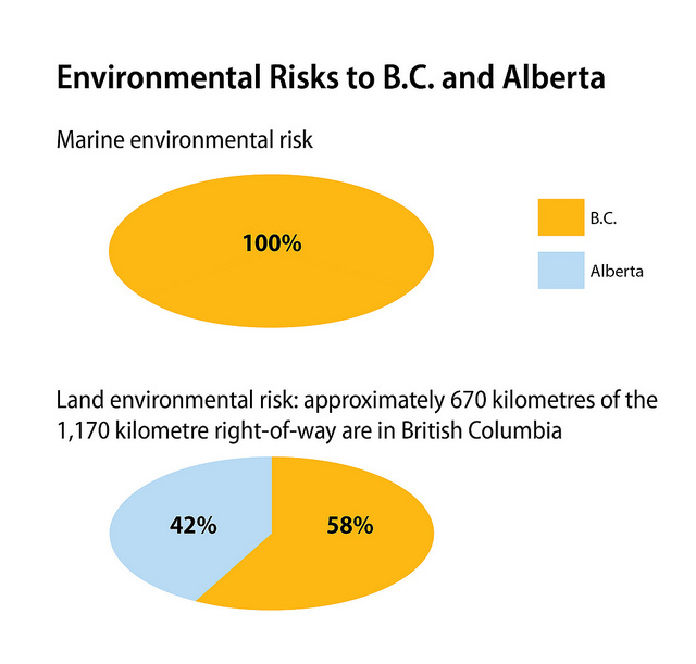
Pie chart of the “environmental risk” from pipeline projects as released by the government of British Columbia

However, trust for the environmental processes has been falling since  Stephen Harper’s government passed Bill C-38 which is designed to fast track approvals and is seen by may in the environmental movement as gutting the review process.

Action plan

The province is also proposing a joint plan of action with the federal government that would include the following elements:

      • Limits to liability that ensure sufficient financial resources to properly address any spills;
        increased federal response capacity;
      • Full adoption of the Unified Command model;
      • Strengthened federal requirements on industry for the provision and placement of marine response equipment and infrastructure;
        Industry-funded terrestrial (land-based) spill co-operative with sufficient human and technical capacity to manage spill risk from pipelines and other land-based sources;
      • Increased capacity within the provincial emergency response program to ensure adequate oversight of industry;
      • A Natural Resources Damage Assessment process to provide certainty that a responsible party will address all costs associated with a spill.

In the release, BC Environment Minister Terry Lake said:  “When we consider the prospect of a heavy oil pipeline, and of the increased oil tanker traffic that would result, it is clear that our spill prevention and response plans will require significant improvements. Our government has already initiated discussions with the federal government on improving our response plans and resources,” said Environment Minister Terry Lake. “This represents an opportunity for British Columbia and Canada to develop world-leading environmental protection regimes.”

First Nations

The government release says

The fourth requirement for the B.C. government to consider support for heavy oil pipeline proposals is First Nations participation. Governments in Canada have a duty to consult and accommodate First Nations, and British Columbia is committed to meeting this test. British Columbia has developed a set of tools to help First Nations to partner with industry and participate in economic development. These agreements help to create certainty for development that benefits all British Columbians. British Columbia remains committed to this approach.

“We believe the benefits to First Nations from major pipeline proposals must be clearly identified, along with the measures that will help protect against environmental impacts,” said Aboriginal Relations and Reconciliation Minister Mary Polak. “As recently as last week, such an approach was endorsed by the Canadian Council of CEOs in their report on Aboriginal participation.”

Show me the money

The government is also emphasizing that the province benefit from any heavy oil project:

Lastly, British Columbia must receive a fair share of the fiscal and economic benefits of any proposed heavy oil project. B.C. will shoulder 100 per cent of the risk in the marine environment and a significant proportion of the risk on the land should a spill event ever occur. Current heavy oil project proposals do not balance the risks and benefits for British Columbia.

“We have identified aggressive environmental requirements and principles for First Nations engagement, and we have clearly stated we expect a fair share of the fiscal and economic benefits for our province,” said Premier Clark. “British Columbians are fair and reasonable. We know we need resource and economic development, but we also expect that risks are managed, environmental protection is uncompromised and that generations will benefit from the decisions we make today.”

BC government graphic on economic benefits
A pie chart, released by the BC government, showing the economic benefits of pipeline projects

In its release, Enbridge repeated its earlier statements that the company will continue
to reach out and encourage conversation with British Columbians about the project through our website and blogs, community meetings and conversations. We have devoted much effort and resources into consultations with communities, First Nations, and Métis…”

The company went on to say:

Enbridge and the Northern Gateway project team have worked hard to ensure this unique project would be built and operated to the highest standards and has committed to further enhancements to make what is already a safe project even safer.

This project will bring real and tangible benefits to the communities and Aboriginal groups along the proposed route, and to the province of British Columbia as a whole.

.

Enbridge files thousands of pages in document dump reply evidence to Northern Gateway JRP

Enbridge Northern Gateway has filed thousands of pages of “reply evidence” to the Northern Gateway Joint Review panel, responding to questions from the panel, from government participants like DFO, and intervenors.

Enbridge also used the filing to issue a news release saying it is adding $500 million in new safety features for its pipeline plans.

Northern Gateway Pipelines Reply_Evidence_  (summary of filings PDF)

Link to 43 item  reply filing on JRP website.

In the introduction to the summary of the evidence the JRP asks

Should the fact that Northern Gateway does not respond to all points in a particular intervenor’s evidence or to all intervenor evidence be taken as acceptance by
Northern Gateway of any of the positions of intervenors?

To which Enbridge replies:

No. Northern Gateway does not accept any of the intervenor positions that are contrary tothe Application or additional material filed by Northern Gateway. Some of those  positions will be dealt with by Northern Gateway in cross examination and argument rather than reply evidence, and others will simply be left to the JRP to determine on the basis of the filed evidence alone.

Related: Vancouver Sun: Christy Clark toughens pipeline stance as Enbridge announces safety upgrades


The reply covers a multitude of topics including

  • Economic Need and the Public Interest
  • Engineering
  • Avalanche Risk and Groundwater Concerns
  • Corrosivity of Diluted Bitumen
  • Improvements Since the Marshall Incident
  • Geotechnical Concerns
  • Geohazards Issues
  • Seismic Design Concerns
  • Recovery of Biophysical and Human Environment from Oil Spills
  • Corrosion, Inspection and Maintenance of Oil Tankers
  • Design and Construction of Oil Tankers
  • Pilotage

In response to numerous questions about the Marshall, Michigan, oil spill, Enbridge repeats what it said in an e-mail to “community leaders” earlier this week and in this morning’s news release, saying: “Enbridge has made a number of improvements since the Marshall incident.”

As part of the filing Enbridge has also filed an update on its aboriginal engagement program.

There are also detailed and updated reports on the company’s plans for the Kitimat valley region.

Enbridge files massive river oil spill study with the Joint Review Panel

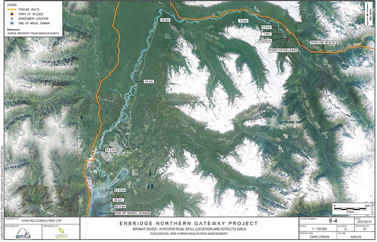
Kitimat River map from Enbridge study
A Google Earth satellite map of the Kitimat River used as part of Enbridge Northern Gateway’s oil spill modelling study.

Enbridge Northern Gateway today filed a massive 11-volume study with the Joint Review Panel outlining possible scenarios for oil spills along the route including the Kitimat and Morice Rivers in British Columbia.

The study, carried out by three consulting firms, Stantec Consuting and AMEC Environmental & Infrastructure both of Calgary and RPS ASA of Rhode Island, is called “Ecological and Human Health Assessment for Pipeline spills.”

Overall the models created by study appear to be extremely optimistic, especially in light of recent events, such as the damning report on by the US
National Transportation Safety Board and the finding of violations by the US Pipeline and Hazardous Material Safety Administration with Enbridge operations during the 2010 Marshall, Michigan, spill and subsequent cleanup difficulties encountered by Enbridge.

The executive summary of the report begins by saying

This document presents conservatively developed assessments of the acute and chronic risk to ecological and human receptors in the unlikely event of a full bore pipeline break on the proposed Enbridge Northern Gateway Pipeline project. Three representative hydrocarbon types (condensate, synthetic oil
and diluted bitumen) were evaluated with releases occurring to four different rivers representing a range of hydrological and geographic characteristics, under both low-flow and high-flow conditions. The analysis indicates that that the potential environmental effects on ecological and human health from each hydrocarbon release scenario could be adverse and may be significant. However, the probability of the releases as considered in the assessment (i.e., full bore rupture, with no containment or oil recovery) is low, with return periods for high consequence watercourses ranging from 2,200 to 24,000 years. Therefore, the significant adverse environmental effects as described in this report are not likely to occur.

So the study says that it is “conservative” that means optimistic, that a full bore pipelink break with no containment or recovery is “an unlikely event” and would probably occur every 2,200 and 24,000 years. Not bad for a pipeline project that is supposed to be operational for just 50 years.

The summary does caution:

The analysis has also shown that the outcomes are highly variable and are subject to a great many factors including the location of the spill, whether the hydrocarbons are released to land or directly to a watercourse, the size of the watercourse, slope and flow volumes, river bed substrate, the amount of suspended particulate in the water, environmental conditions (such as the time of year, temperature and wind speeds, precipitation, etc.), the types of shoreline soils and vegetative cover and most significantly, the type and volume of hydrocarbon released.

The highly technical study is Enbridge’s official response to those intervenors who have “requested additional ecological and human health risk assessment studies pertaining to pipeline spills” and a request from the Joint Review Panle for more information about “the long term effects of pipeline oil spills on aquatic organisms (including the sensitivity of the early life stages of the various salmon species), wildlife, and human health.”

The report presents modelling on the release of three hydrocarbons, diluted bitumen, synthetic oil and condensate at four river locations along the pipeline route for their potential ecological and human health effects, under two flow regimes (i.e., high and low flow), broadly representing summer and winter conditions.

Modelling was done for four areas:

• Chickadee Creek: a low gradient interior river tributary discharging to a large river system
located up-gradient from a populated centre within the Southern Alberta Uplands region
• Crooked River: a low gradient interior river with wetlands, entering a lake system within
the Interior Plateau Region of British Columbia
• Morice River: a high gradient river system along the western boundary of the Interior
Plateau Region of British Columbia
• Kitimat River near Hunter Creek: a high gradient coastal tributary discharging to a large
watercourse with sensitive fisheries resources, downstream human occupation, and discharging to the Kitimat River estuary

In one way, the study also appears to be a partial victory for the Kitimat group Douglas Channel Watch because the model for the Kitimat River is based on a spill at Hunter Creek, which has been the subject of extensive work by the environmental group, but the consulting study is markedly optimistic compared to the scenario painted by Douglas Channel Watch in its presentations to District of Kitimat council.

The study describes the Kitimat River:

The hypothetical release location near Hunter Creek is southwest of Mount Nimbus, in the upper Kitimat  River watershed, and flows into Kitimat River, then Kitimat Arm, approximately 65 km downstream. The area is in a remote location and maintains high wildlife and fisheries values. The pipeline crossing near Hunter Creek is expected to be a horizontal direction drilling (HDD) crossing. The release scenario
assumes a discharge directly into Kitimat River…

The streambed and banks are composed of coarse gravel, cobbles and boulders. Shoreline vegetation (scattered grasses and shrubs) occurs in the channel along the tops of bars. Vegetation is scattered on the channel banks below the seasonal high water mark and more developed (i.e., grasses, shrubs and trees) bove the seasonal high water mark.

Wildlife and fish values for the Kitimat River are high: it is important for salmon stocks, which also provide important forage for grizzly bears, bald eagles and osprey on the central coast. The Kitimat River estuary, at the north end of Kitimat Arm, also provides year-round habitat for some waterbirds and seasonal habitat for staging waterfowl.

There is considerable recreational fishing, both by local people and through fishing guides, on Kitimat River, its estuary and in Kitimat Arm. There is also likely to be a high amount of non-consumptive recreational activity in the area, including wildlife viewing, hiking and camping. The Kitimat River estuary, for example, is well known for waterbird viewing.

While no fish were captured at this location during the habitat survey, salmonoid fry and coho salmon were observed downstream. Previously recorded fish species in the area include chinook, coho and chum salmon, rainbow trout, Dolly Varden, and steelhead trout.

However, the next paragraph appears to show that a full bore rupture on the Kitimat River would have widespread consequences because it would cover a vast area of First Nations traditional territory, saying

Aboriginal groups with traditional territories within the vicinity of the Kitimat River hypothetical spill scenario site include the Haisla Nation, Kitselas First Nation, Kitsumkalum First Nation, Lax-Kw’alaams First Nation and Metlakatla First Nation.

It also acknowledges:

Oral testimony provided by Gitga’at First Nation and Gitxaala Nation was also reviewed in relation to this hypothetical spill scenario, although the traditional territories of these nations are well-removed from the hypothetical spill site.

The report then goes on to list “the continued importance of traditional resources” for the aboriginal people of northwestern BC.

especially marine resources. People hunt, fish, trap and gather foods and plants throughout the area and traditional foods are central to feasting and ceremonial systems. Food is often distributed to Elders or others in the community. Written evidence and oral testimony reported that Coho, sockeye, pink, and spring salmon remain staples for community members. Halibut, eulachon, herring and herring roe,
various species of cod, shellfish, seaweed, and other marine life are also regularly harvested and consumed, as are terrestrial resources, including moose, deer, beaver, muskrat and marten. Eulachon remains an important trade item. Written evidence provides some information on seasonality of use and modes of preparation. Seaweed is dried, packed and bundled and preserved for later use. Each species of
salmon has its own season and salmon and other fish are prepared by drying, smoking, freezing or canning. Salmon are highly valued and often distributed throughout the community…

Some areas used traditionally are not depicted geographically. Upper Kitimat River from the Wedeene River to the headwaters has long been used for trapping, hunting, fishing and gathering of various foods. Fishing, hunting and gathering activities take place along the lower Kitimat River and its tributaries. Marine resources are collected in Kitimat Arm, Douglas Channel, and Gardner Canal. Old village and
harvesting sites are located along the rivers and ocean channels in this vicinity.

Intertidal areas are important and highly sensitive harvesting sites that support a diversity of species. Many intertidal sites are already over harvested and are therefore vulnerable. Conservation of abalone has been undertaken to help the species recover. Some concern was expressed in oral testimony regarding the
potential for archaeological sites and the lack of site inventory in the area. Oral testimony made reference to the Queen of the North sinking and the potential for a similar accident to result in human health and environmental effects.

A spill at Hunter Creek

The model says that all three types of floating oil in Kitimat River under high-flow conditions would reach approximately 40 kilometres downstream from Hunter Creek while low-flow conditions showed variation.

Under what the study calls low flow conditions, most condensate would evaporate. The bitumen would cause “heavy shore-oiling” for the first 10 kilometres, with some oiling up to 40 kilometres downstream.

The most sedimentation would occur for synthetic oil, and the least for condensate. Synthetic oil under both flow conditions would have the largest amounts deposited to the sediments. This is because of the low viscosity of synthetic oil, which allows it to be readily entrained into the water where it may combine with suspended sediments and subsequently settle. Synthetic oil under high-flow conditions would result in the most entrained oil and so the most extensive deposition to the sediment. Diluted bitumen, for both flow conditions, would result in the most deposited on shorelines, with the remainder (except that which evaporated or degraded) depositing to the sediments.
The condensate also would also have significant entrainment, but higher winds prevailing in under low flow conditions would enhance evaporation and rapidly lower concentrations in the water as compared to high-flow conditions. In all scenarios, a large amount of entrained oil and high concentrations of dissolved aromatics would move down the entire stretch of Kitimat River and into Kitimat River estuary.

Long term scenario

The modelling appears to be extremely optimistic when it reaches four to six weeks after the pipeline breach, especially in light of the continued cleanup efforts in Michigan, estimating that the “fast-flowing” nature of the Kitimat River would disipate all the different forms of hydrocarbon in the study saying

 a fast-flowing coastal river like Kitimat River, with gravel or cobble bottom would be affected by a large volume of crude oil released in a short period of time.

Oiling of shoreline soils is heavy in the reaches between the release point and 10 km downstream, becoming lighter to negligible beyond 10 km. Deposition of hydrocarbons to river sediment is greatest for the synthetic oil and diluted bitumen (high flow) scenarios extending up to 40 kilometres downriver, with predicted hydrocarbon concentrations in sediment approaching 1,000 mg/kg dry weight. Deposition of hydrocarbons to river sediment is considerably lighter for the diluted bitumen (low flow) and condensate scenarios. In these scenarios, oiling of river sediment is negligible….

It says that within four weeks of the end of the acute phase of the spill scenarios, concentrations in river sediments and river water would decline becoming quite low at the end of two years.

As for the affects on plants and invertebrates:

Oiling of shorelines would be extensive, particularly at assessment locations within 10 kilometres of the pipeline break location, under both the high and low flow scenarios, for synthetic oil and condensate. High loadings occur as far as 25 kilometres downstream, again asusming that damage would begin to disipate after four weeks declining over the next one to two years. Predicted effects are generally less severe for the diluted bitumen spill scenarios, due to lower expected loading of oil onto shorelines. Low to negligible shoreline oiling would occur for Kitimat River under most of the scenarios at the 40 kilometres assessment location and points downstream. Based on this assessment, very little oiling of shorelines would extend to the estuary and the environmental effects would be minimal.

The study goes on to say that the “model suggests that there would be no significant risk to fish health based upon chronic exposure to petroleum hydrocarbons  for the oil spill scenarios in Kitimat River or the potentially affected areas within the estuary, either at four weeks or one to two years following the hypothetical spill events. Risk to developing fish eggs in Kitimat River and estuary at four weeks and one to two years again indicate no significant risk to developing fish eggs in spawning gravels.”

It also claims that “chronic risks” to wildlife would be minimal, with some elevated risk for “muskrat, belted kingfisher, mallard duck, spotted sandpiper and tree swallow,” if they were exposed to synthetic oil. The muskrat, mallard duck and spotted sandpiper
could be vulnerable to bitumen and diluted bitumen.

It then claims that “no significant effects of chronic exposure (to all hydrocarbons) would occur for grizzly bear, mink, moose, river otter, bald eagle, Canada goose, herring gull or great blue heron for the Kitimat River hydrocarbon spill scenarios.”

Again, it appears from the sutdy that the spotted sandpiper would be most vulnerable to “bulk weathered crude oil exposure” includingcondensate, diluted bitumen and synthetic oil.

For the Kitimat section it concludes:

In the unlikely event of an oil spill, recovery and mitigation as well as the physical
disturbance of habitat along the watercourse would be likely to substantially reduce the exposure of wildlife receptors to hydrocarbons as compared to the scenarios evaluated here.

Link to Volume One of the Enbridge Northern Gateway Report Ecological and Human Health Assessment for Pipeline Spills

JRP denies most requests from Coastal First Nations to question BC on Northern Gateway

The Northern Gateway Joint Review Panel has denied four out of the five requests from Coastal First Nations to question the province of British Columbia about its position on the controversial pipeline and tanker project. A decision on the fifth request is reserved pending a response from the province and other parties.

So far, the province has not participated in the Joint Review hearings nor has it filed any evidence.

A five part motion by the Coastal First Nations was an attempt to compel the government of Premier Christy Clark to participate.

The motion requested

a) compel the Province of British Columbia (Province) to file a technical report that was reported on in the Globe and Mail on 3 June 2012;

b) compel the Province to file any other reports or assessments it has;

c) allow intervenors to file information requests on any evidence filed by the Province;

d) compel the Province to indicate whether or not it will issue a Certificate for the
Project pursuant to the BC Environmental Assessment Act; and

e) compel the Province to indicate whether it intends to consult with First Nations on the
Project, and if so, how and when.

The JRP reserved its judgement on the request on item (a) to release the report mentioned in the Globe and Mail. A few days after Coastal First Nations made the request, lawyers representing the province requested an extension to respond to the CFN motion. The JRP gave both BC and Northern Gateway until July 16 to respond and then the CFN has until July 20 to reply.

On item (b) forcing the province to release other assessments, the JRP ruled that the information requested was “unclear and excessively broad” and so the request was denied.

On item (c) allowing intervenors to question on evidence from the province, the JRP ruled that Coastal First Nations had requested “a blanket right for parties to ask information
requests on evidence that is not yet filed.” The JRP said “ not persuaded that all parties ought to be given a blanket right to ask information requests on evidence that is not yet filed” and denied the request. The JRP added: “If a party believes it needs to ask a late information
request (as opposed to asking a hearing question) on specific evidence, the Panel will consider
that request.”

On items (d) and (e) the panel cited constitutional concerns, saying it related to authorizations in provincial jurisdiction and ruled “No justification is provided as to why this
information would be relevant to the federal review….” The JRP said it was “persuaded that it has any legal authority over these areas of provincial jurisdiction, or that it would be appropriate or relevant to the federal review, to obtain information about provincial affairs.”

JRP Ruling No 60 CFN Notice of Motion

Enbridge question on “marine vessel activity” on Douglas Channel gets obvious answer from the Haisla

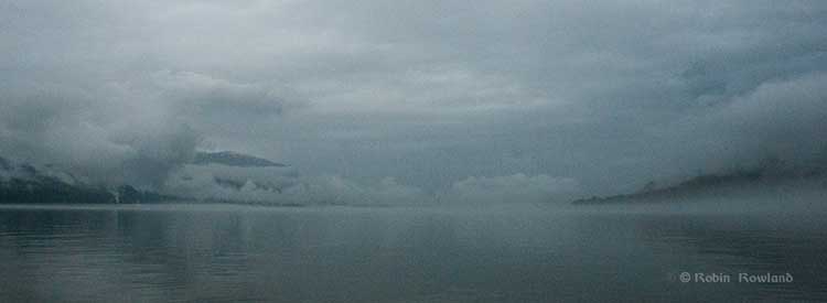
Fog shrouds Kitimat harbour
Fog and low clouds shroud Kitimat harbour on the morning of June 27, 2012. (Robin Rowland/Northwest Coast Energy News)

If there is a major disconnect between the people who live in the Kitimat region and the rest of Canada, it is the question of vessel traffic on the Douglas Channel, with Enbridge spinning that there is already major tanker traffic on the Channel.

This section from the Northern Gateway website, is often quoted by Enbridge supporters, the vast majority of whom live in Alberta, thousands of kilometres away, have never been to Kitimat, but, somehow from Calgary or Fort McMurray,  claim to know more about the Douglas Channel than people who live in Kitimat, including those who have sailed Douglas Channel for decades.

On its website Northern Gateway claims

According to numbers from the Port of Kitimat, not only have vessels carrying industrial products been travelling the channels safely for some 35 years, but so too have ships carrying petroleum products—like the one featured arriving in the Port of Kitimat through the Douglas Channel in the picture above.
In fact, some 1,560 vessels carrying methanol and condensate called on Kitimat port from 1982 to 2009 – that’s over 3,100 transits of vessels dedicated to the transport of petroleum products.
When you add vessel traffic of all industrial activity into Kitimat port, the number jumps to 6,112.
To be clear…the number of ships servicing industry arriving at Kitimat port between 1978 and 2009 is 6,112. That’s 12,224 transits!

So in its questions to the Haisla, Enbridge asked:

c) Please confirm that the Haisla Nation is aware of existing and proposed
marine vessel activity within its Traditional Territory, including:

(i) fuel barges

(ii) cargo/container ships

(iii) commercial fishing vessels

(iv) condensate tankers

(v) liquefied natural gas tankers


Enbridge’s question was an obvious attempt to enhance their spin on vessel traffic on the Douglas Channel, by fishing for an admission that large vessels already ply the Channel, something the residents of the Kitimat, both First Nations and non-aboriginal already know well.

In its response, the Haisla Nation replies:

The Haisla Nation is aware of the existing and proposed marine vessel activity within its Territory, including fuel barges, cargo/container ships, commercial fishing vessels, condensate tankers, and liquefied natural gas tankers.

The Haisla Nation is also aware of the increased cumulative effect of additional marine vessel activity as projects are approved. The presence of this shipping increases the significance of the potential impacts of the project on Haisla Nation aboriginal title and rights, through cumulative impacts.

The Haisla Nation is responsible for some of the vessel traffic within its Territory, with modern forms of transportation having replaced canoes. Until legal developments in the early 2000s which have defined the content of the honour of the Crown with respect resource decisions and potential impacts on First Nations, the Haisla Nation had little say about the projects with associated vessel traffic in its Territory.

While standard petroleum product tankers, many carrying condensate, a natural gas product, have been visiting Kitimat for years, there have. so far, been no supertankers, much less Very Large Crude Carriers. No bitumen carrying tankers have visited Kitimat, a fact always ignored by the region’s critics in Alberta and by Enbridge on its website.

Not only the filing by the Haisla Nation but most of the testimony at the recent public comment hearings in at Kitamaat Village, were about the fear of the growing cumulative effect of greatly increased tanker traffic on the Channel.