TransCanada plans rugged over-mountain route for gas pipeline to Kitimat


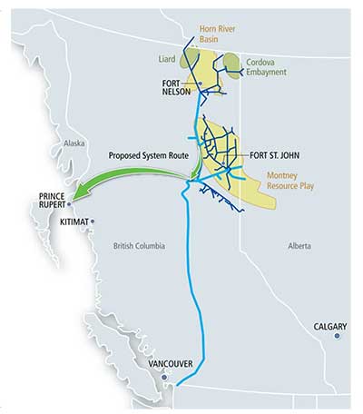
Coastal GasLink map
A map from TransCanada’s Coastal GasLink showing the conceptual route of the proposed natural gas pipeline from the shale gas fields in northeastern BC through the mountains to Kitimat and the proposed Shell LNG facility. (TransCanada)

TransCanada plans a rugged over-mountain route for its proposed Coastal Gaslink pipeline to the Shell Canada liquified natural gas project in Kitimat, BC, company officials said Monday, Oct. 15, 2012, in two presentations, one to District of Kitimat Council and a second at a community town hall briefing.

The pipeline would initially carry 1.7 billion cubic feet of natural gas per day from the Montney Formation region of northeastern British Columbia along a 48 inch (1.2 metre) diameter pipe over 700 kilometres from Groundbirch, near Dawson Creek, to Kitimat, site of the proposed Shell Canada LNG Canada project.

Rick Gateman, President of Coastal GasLink Project, a wholly owned TransCanada subsidiary told council that the project is now at a “conceptual route” stage because TransCanada can’t proceed to actual planning until it has done more detailed survey work and community consultations.

At the same council meeting, documents from Shell Canada notified the District that it has formally applied to the National Energy Board for an export licence for the natural gas.

Rick Gateman
Rick Gateman, president of TransCanada’s Coastal GasLink addresses District of Kitimat Council, Oct. 15, 2012. (Robin Rowland)

Gateman told council that since the pipeline itself will be completely within the province of British Columbia, it comes under the jurisdiction of the British Columbia Environmental Assessment process and the BC Oil and Gas Commission and that the NEB will not be involved in approving the pipeline itself.

At first, the Coastal Gas Link pipeline would be connected to the existing Nova Gas Transmission system now used (and being expanded) in northeastern British Columbia.

From Vanderhoof, BC to west of Burns Lake, the Coastal GasLink pipeline would be somewhat adjacent to existing pipelines and the route of the proposed Enbridge Northern Gateway bitumen pipeline and the proposed Pacific Trails natural gas pipeline.

Somewhat south of Houston, however, the pipeline takes a different route from the either the Northern Gateway or Pacific Trails Pipeline, going southwest, avoiding the controversial Mount Nimbus route.

Howard Backus, an engineering manager with TransCanada told council that the route changes so that Coastal GasLink can avoid “congestion” in the rugged mountain region.

Backus said that the Pacific Trails Pipeline for Apache and its partners in the Kitimat LNG project “is skirting” Nimbus while Enbridge plans to tunnel through the mountain. That tunnel is one of the most controversial aspects to the Northern Gateway project. The local environmental group Douglas Channel Watch has repeatedly warned of the dangers of avalanche and geological instability in the area where the Northern Gateway pipeline emerges from the tunnel. Enbridge has challenged Douglas Channel Watch’s conclusions in papers filed with the Northern Gateway Joint Review panel.

Under TransCanada’s conceptual route, the pipeline heads southwest and then climbs into the mountains, crossing what Backus calls “a saddle” (not a pass) near the headwaters of the Kitimat River. The pipeline then comes down paralleling Hircsh Creek, emerging close to town, crossing the Kitimat River and terminating at the old Methanex plant where Shell plans its liquified natural gas plant. (That means that if the conceptual plans go ahead, the TransCanada pipeline would climb into the mountains, while Pacific Trails finds a way around and Enbridge tunnels).

Backus told council that going north “created more issues,” but did not elaborate.

Backus assured people at the town hall that energy companies have a lot of experience in building pipelines in mountainous areas, including the Andes in South America.

Asked by a local businessman at the town hall if it was possible to build a road along the route of the pipeline, Backus said the mountain areas would be too steep.  Any pipeline maintenance would have to be done by tracked vehicle, he said.

Gateman told council that the pipeline would be buried along its entire route. If Shell increases the capacity of its LNG facility in Kitimat, the Coastal Gaslink pipeline could increase to 3.4 billion cubic feet a day or perhaps even more. For the initial capacity, the company will have one compressor station at the eastern end of the line. If capacity increases or if the route requires it, there could be as many as five additional compressor stations. (TransCanada’s long term planning is based on the idea that Shell will soon be adding natural gas from the rich Horn River Formation also in northeastern BC to the Kitimat export terminal.)

TransCanada will begin its field work, including route and environmental planning and “community engagement” in 2013 and file for regulatory approval in 2014. Once the project is approved, construction would begin in 2015.

Gateman said that TransCanada is consulting landowners along the proposed right of way and “on a wide area on either side.” The company also is consulting 30 First Nations along the proposed route. Gateman told council, “We probably have the most experience of any number of companies in working directly with and engaging directly with First Nations because of our pipelines across Canada.”

(Despite Gateman’s statement, the TransCanada maps showed that the Coastal Gaslink Pipeline would cross Wet’suwet’en traditional territory and officials seemed to be unaware of the ongoing problems between Apache and the Pacific Trails Pipeline and some Wet’suwet’en Houses who oppose that pipeline).

Gateman told council that the pipeline would be designed to last at least 60 years. He said that in the final test stages, the pipeline would be pressured “beyond capacity” using water rather than natural gas to try and find if any leaks developed during construction.

He said that the company would restore land disrupted by the construction of the pipeline, but noted that it would only restore “low-level vegetation.” Trees are not permitted too close to the pipeline for safety reasons.

TransCanada made the usual promises the region has heard from other companies of jobs, opportunities for local business and wide consultations. (TransCanada may have learned lessons from the botched public relations by the Enbridge Northern Gateway. A number of Kitimat residents have told Northwest Coast Energy News that TransCanada was polling in the region in mid-summer, with callers asking many specific questions about environment and the spinoffs for communities).

Councillor Phil Germuth questioned Gateman about the differences between a natural gas pipeline and a petroleum pipeline. Gateman replied that the pipelines are pretty much the same with the exception that a natural gas pipeline uses compressor stations while a petroleum pipeline uses pumping stations. Gateman did note that the original part of the controversial Keystone XL pipeline that would carry bitumen through Alberta and US mountain states to Texas was a natural gas pipeline converted to carry the heavier hydrocarbons.

Although the natural gas projects have, so far, enjoyed wide support in northwestern British Columbia, environmental groups and First Nations have raised fears that sometime in the future, especially if there is overcapacity in natural gas lines, that some may converted to bitumen, whether or not Northern Gateway is approved and actually goes ahead.

Shell application to NEB

In a fax to District of Kitimat council, Shell Canada Senior Regulatory Specialist Scot MacKillop said that the Shell had applied to the National Energy Board on September 25, 2012 for a licence to export LNG via Kitimat for the next 25 years.

The Shell proposal, like the previous Kitimat LNG and BC LNG proposals, are export applications, unlike the Enbridge Northern Gateway which is a “facility application.”
In its letter to Shell’s lawyers, the NEB took pains to head off any objections to the project on environmental or other grounds by saying:

the Board will assess whether the LNG proposed to exported does not exceed the surplus reaming after due allowance has been made for the reasonably foreseeable requirements for use in Canada. The Board cannot consider comments that are unrelated…such as those relating to potential environmental effects of the proposed exportation and any social effects that would be directly related to those environmental effects.

Rio Tinto Alcan reopens access to Kitimat waterfront

Rio Tinto Alcan has reopened Hospital Beach, the nearby boat ramp and Moore Creek and the Moore Creek falls for public use.

RTA took out an ad in a local newspaper Wednesday, Oct. 12, 2012, to make the announcement which came after a meeting members of the District of Kitimat Council on Oct. 4.

The RTA statement reads, in part:

Both Rio Tinto Alcan and the District of Kitimat understand the value and importance of ocean access to residents of the area while at the same time, continuing to respect and ensure that safety is the number one priority.

Over the last few months, while hearing the disappointment and concern about Hospital Beach, the KMP [Kitimat Modernization Project] Construction Team took action to mitigate the public safety risk. The massive rock trucks hauling heavy loads will be re-routed; a new bridge over Anderson Creek has been installed; new traffic lights will be installed near the Construction Village; and an extra construction road has been built from the former Eurocan Haul Road. All these measures have enabled the decision to accommodate the wishes of the community to access Hospital Beach, the boat ramp and Moore Creek safely.

It is important to remind residents however, Rio Tinto Alcan is in the middle of constructing a mega project to modernize and sustain the aluminium smelter business in Kitimat for the benefit of us all. This is the highest priority with many demands and intense focus. To that end, Rio Tinto Alcan will continue to assess traffic patterns and will likely need to make short term closures again as construction dictates. It is imperative that residents respect the company’s right to manage activities on its private property as it deems in the best interest of its business, including the KMP and public safety.

Rio Tinto Alcan and the District of Kitimat have committed together to work toward finding long term solution to ocean access. Thank you all for your patience, support and cooperation.

As the members of District council were meeting in Kitimat, in Prince Rupert, the Northern View reported that CN was cutting off access to part of the town’s waterfront, again for safety issues: CN erects barriers, no trespassing signs along Prince Rupert waterfront

Prince Rupert residents wanting to walk along the road adjoining the ocean past Rotary Waterfront Park will notice new barriers and signs alerting them that they would be trespassing should they do so.
The barricades and signs were put up yesterday, and CN regional manager of public affairs Emily Hamer says it is due to safety concerns with the public on the railway’s property.

Prince Rupert acting mayor Anna Ashley told the Northern View the city expected some restrictions during construction and said the city planned to talk to CN about the issue.

In an e-mail to Northwest Coast Energy News after the October 4 meetingm Kitimat mayor Joanne Monaghan, while hinting  then that a solution to the restrictions was coming, said that industry has been faced with so many lawsuits that safety is becoming a bigger issue.

Councillor Corinne Scott also said that the meeting with RTA stressed that “Large businesses are putting safety as a higher priority.” (She also noted that council agreed to have regular meetings with RTA “.communication lines are open and we look forward to a continued good working relationship between the District of Kitimat and RTA. “)

In both cases, it appears that waterfront access is a legacy issue, left over from an earlier era of industrial development that gave little thought to either the environment or community.
Now it is also apparent that liability lawyers, who probably live thousands of kilometres away from the northwest, have, so far, been driving this issue, with little regard for the needs of local residents.

Make no mistake, safety should be a high priority, but arbitrary restrictions that may look good on legal brief, could actually mean that people would simply try to get around the restrictions, to the determent of safety. It is well known that RTA Plant Protection was finding people at Hospital Beach during the summer, especially at night, despite the publicized restrictions,  barriers and warning signs.

Today with a strong need for jobs in northwestern British Columbia, future community needs for access to waterfront and green space (even in such a wide green area as northern BC) must be taken into consideration in municipal and corporate planning. If that planning isn’t done, that will mean that while there could be jobs, the northwest could be in a situation as it was this summer, with no way to enjoy the advantages of waterfront life in northern BC.


Four energy giants update multi-billion dollar Alaska LNG development plans

Energy company logos

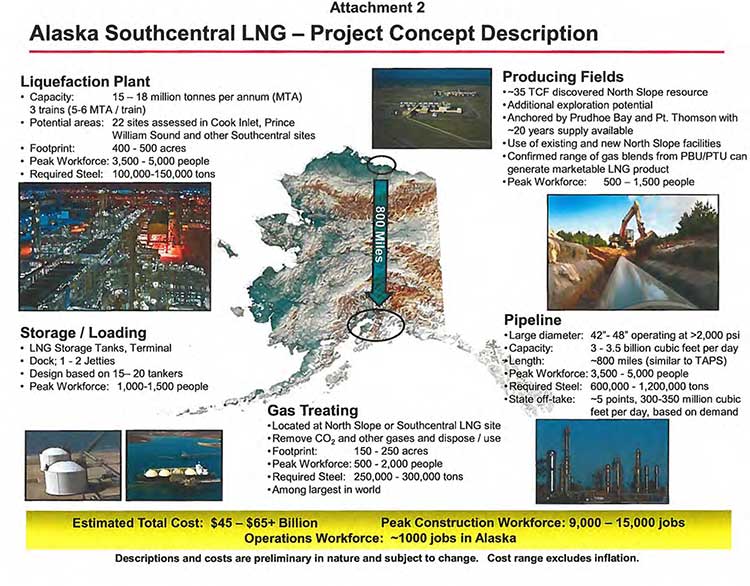
An alliance of four energy companies has updated plans for a multi-billion dollar, ten-year liquefied natural gas megaproject that would take gas from Alaska’s North Slope for shipment to Asia through the oil port at Valdez.

Three of the companies, Exxon Mobile, ConocoPhillips and BP already have operations on the North Slope. TransCanada,which is already planning to build a gas pipeline for the Kitimat Shell project, would be the fourth partner and also work on the pipeline.

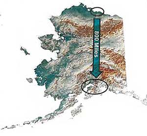
Map of Alaska LNG project The four companies filed a letter on October 1 with Alaska Governor Sean Parnell outlining the plans, The governor’s office released the letter today.

The companies told Gov. Parnell that their efforts would result in “a megaproject of unprecedented scale and challenge; up to 1.7 million tons of steel, a peak construction workforce of up to 15,000, a permanent workforce of over 1,000 in Alaska, and an estimated total cost in today’s dollars of $45 to $65+ billion.”


Related:Alaska governor meets with three energy CEOs to push North Slope LNG exports to Asia

The letter goes on to say that TransCanada’s recently completed non-binding solicitation of
interest in the project and that company “has publicly reported interest from potential shippers and major players from a broad range of industry sectors and geographic locations.” (An expression of interest, of course, doesn’t mean that buyers will actually sign contracts, as the Kitimat LNG partners are finding out)

It appears from the letter that the North Slope producers are, in the long term, worried about diminishing oil reserves and are now, like energy companies around the world, looking at cashing in on the natural gas boom.

This opportunity is challenged by its cost, scale, long project lead times, and reliance upon interdependent oil and gas operations with declining production. The facilities currently used for producing oil need to be available over the long-term for producing the associated gas for an LNG project. For these reasons, a healthy, long-term oil business, underpinned by a competitive fiscal framework and LNG project fiscal terms that also address AGIA issues [an Alaska state agency], is required to monetize North Slope natural gas resources. The producers look forward to working with the State to secure fiscal terms necessary to support the unprecedented commitments required for a project of this scope and magnitude and bring the benefits of North Slope gas development to Alaska.

Over the past few months, the partners have, according to the letter:

•Developing a design basis for the pipeline, including areas of continuous and discontinuous permafrost
•Investigating multiple ways to remove and dispose of CO2 and other contaminants
•Assessing use of existing and addition of new Prudhoe Bay field facilities
•Mapping multiple pipeline routing variations
•Assessing multiple pipeline sizes
•Providing for at least five in-state gas off-take points
•Completing preliminary geohazard and marine analysis of 22 LNG site locations
•Developing a design basis for the required LNG tanker fleet
•Evaluating multiple LNG process design alternatives
•Confirming a range of gas blends from the Prudhoe Bay and Point Thomson fields can generate a marketable LNG product

The letter concludes:

Our next steps are to complete the concept selection phase and work with the State to make meaningful progress on the items detailed above. This work is critical as we consider decisions to progress the next phases of an LNG development project.

Alaska’s North Slope natural gas resources must compete in the global energy markets in order to deliver state revenues, in-state energy supplies, new job opportunities and other economic benefits to Alaskans. While North Slope gas commercialization is challenging, working together, we can maintain the momentum toward our shared vision for Alaska. We will continue to keep you advised of our progress and stand committed to work with the State to responsibly develop its considerable resources.

Alaska LNG fact sheet
A fact sheet on the Alaska LNG project sent to the state governor by the project partners.


LNG partners letter to Alaska governor  (PDF)

TransCanada to hold community briefing in Kitimat October 15

TransCanada will hold a community briefing in Kitimat on October 15, 2012, at Riverlodge to inform residents of its plans for its subsidiary Coastal GasLink Pipeline, which would carry natural gas for the Royal Dutch Shell LNG project.

In a letter to District of Kitimat Council, TransCanada said it the Kitimat would be one of several sessions across northern British Columbia.

The public information session will include maps “showing our conceptual route as well as information on community benefits, environmental management and other aspects of our project.  Coastal Gaslink project representatives  will be available to answer questions and share information.”

The session will be a the Riverlodge Rescreation Centre from 4:30 p.m. to 8:30 p.m. On October 15.

Kitimat LNG progressing–or is it?

At the District of Kitimat Council meeting on Monday, October 1, as part of Mayor Joanne Monaghan’s regular “good news” briefing, she told council that the Kitimat LNG  project continues to “progress positively.”  The news from Calgary on Tuesday, however, was not as promising.

Both Bloomberg News and the Calgary Herald reported that  Apache, which owns 40 per cent of the KM LNG partnership is worried about a recent decision by a rival gas company to sell natural gas to world markets at low North American prices rather than, as been customary up until now, as percentage of the world oil price. That differential gives the North American gas companies a profit in Asia and it is that profit difference that makes Kitimat attractive for LNG projects.

At the council meeting, Monaghan reported, quoting Apache’s  Apache’s Manager of Public and Government Affairs Natalie Poole-Moffatt, as saying that  Kitimat LNG will be opening a full time community office in downtown Kitimat near the City Centre mall in the near future.  Apache says renovations are nearly complete and they will be holding an open house in the near future.

Monaghan said that work on the Kitimat LNG site at Bish Cove continues with blasting to create proper elevation, crushing and sorting of rock and constructing an access route to the forest service road. This summer work began on the two year $25 million upgrades to the old forest service road “which will improve conditions on the road.”

However, in Calgary, the Herald quoted KM LNG vice-president David Calvert as saying “things are going so well that it has been decided to risk spending on clearing ground before completion of the front end engineering and development study and final investment decision.”

But according to several media reports,  Calvert told an Energy Roundtable in Calgary on Tuesday that a final go-ahead for Kitimat LNG is not a done deal. the Herald quoted Calvert as saying: “We remain convinced that oil-linked pricing is critical to the viability of our Canadian LNG industry.”

Bloomberg reported that a recent deal by Cheniere Energy Inc. to sell liquefied natural gas based on North American pricing (also known as Henry Hub pricing) means that it is difficult for Apache to find Asian customers to sign the long term LNG contracts needed to make the Kitimat project viable. (Asian LNG prices are based on the “Japan Customs Cleared Price” set by the Japanese government as a percentage of the price of crude oil).

Bloomberg quoted Calvert as saying: “It created quite a ripple through the marketplace,” and Bloomberg said, the Cheniere deal has created “unrealistic expectations.”

Related

Globe and Mail

Canadian gas producers dreaming big – again 

Canada losing the race to sell LNG

Updated

The Haynesville Shale

Cheniere Deal Hurts Canadian LNG Project

Cheniere is less sensitive to prices given its role as a middleman, while Apache, Encana and EOG are producers, for whom the price is very important.  One advantage of Kitimat is its west coast location, but that is only a minor cost advantage over Gulf Coast facilities.

The clock is ticking on Kitimat.  It sounds like Asian buyers are sitting on the sidelines waiting for lower prices.  Right now the U.S. government is sitting on future LNG approvals pending the release of a study around year-end.  If the U.S. approves the pending applications, a proverbial flood of LNG will come to market with Henry Hub-based pricing.  At that point Kitimat’s owners will be in a tough spot.  Kitimat is vital to B.C., but the economics might not work.

Wall Street Journal

Cheniere Lights a Match in the Gas Market


Minor oil leak at Bish Cove

In a report to District of Kitimat Council, Apache’s Manager of Public and Government Affairs,  Natalie Poole-Moffatt,  also reported that on September 19, an oil leak was spotted on a piece of heavy equipment at Bish Cove.  The report says;

WestCoast Marine was notified and booms were deployed as a preemptive measure in Bish Cove, no machine oil has migrated to Bish Cove. Environmental crews are on site executing a remediation plan.  Both the [BC] Provincial Emergency PLan (PEP) and Aboriginal and Northern Affairs Canada  were notified of the incident.

The piece of equipment  is currently being repaired and will undergo operational tests to ensure  the equipment can function without further concern.  Environmental staff will remain on the site 24/7 until remediation is complete.

Spectra Energy, BG Group propose natural gas pipeline to Prince Rupert, creating fourth NW BC LNG project

Spectra Energy Corp of Houston, Texas, today announced that the company has signed a Project Development Agreement with BG Group PLC, based in the United Kingdom, to jointly develop plans for a natural gas transportation system from northeast B.C. to serve BG Group’s potential liquefied natural gas (LNG) export facility in Prince Rupert.

The BG group signed an agreement last February with the Prince Rupert Port Authority  for a feasibility study to develop an LNG terminal at the port.

Spectra Energy BC project map
A map released by Spectra Energy shows the proposed pipeline project from the shale gas fields of northeastern BC to Prince Rupert (Spectra Energy)


A release from Spectra Energy and BG Groupsays each company will initially own a 50 per cent interest in the proposed transportation project. Spectra Energy will be responsible for construction and operation and BG Group has agreed to contract for all of the proposed capacity.

The approximately 850-kilometre, large diameter natural gas transportation system will begin in northeast B.C. and end at BG Group’s potential LNG export facility in Prince Rupert.

A fact sheet released by Spectra says the project would provide 50 to 60 permanent jobs on completion and about 4,000 jobs during construction.

BC Group logoThe Spectra BG project will be the fourth using BC’s strategic position on the Great Circle Route to Asia to export liquified natural gas. TransCanada has signed a deal with Shell for a pipeline, Coastal GasLink, that would initially carry up to 1.7-billion cubic feet a day of gas to the Shell Canada project at Kitimat The Pacific Trails pipeline, could carry more than 1-billion cubic feet a day to the KM LNG partners ship where Apache, EOG and Encana are building a terminal at Bish Cove, south of Kitimat. The fourth project, BC LNG, would use either existing pipelines or share one of the proposed Kitimat pipelines to produce LNG for customers at a barge-based floating terminal at what is sometimes called North Cove, between the KM LNG project at Bish Cove and the proposed Enbridge Northern Gateway project which would be close to the Rio Tinto Alcan smelter.

Spectra Energy LogoThe Spectra release says the new transportation system will be capable of transporting up to 4.2 billion cubic feet per day of natural gas. The project will connect with the Spectra Energy facility at Fort St. John, the centre of the still growing shale gas production and exploration in the northeastern BC.

Greg Ebel, president and chief executive officer, Spectra Energy says in the release:

We are excited to be partnering with BG Group, a recognized world leader in natural gas and more specifically, LNG. This project offers B.C. a unique opportunity to access new markets, strengthen its energy infrastructure, engage stakeholders in economic growth and job creation, and ultimately secure the province’s position as a competitive energy leader.

Furthermore, today’s announcement initiates our next wave of investment opportunity in B.C.  We are ideally positioned to create further value for our investors by leveraging surplus B.C. natural gas supplies and facilitating its export to high-demand markets in Asia. This, in turn, will provide multiple opportunities for further investment in our gathering and processing facilities in the province.

Doug Bloom president of Spectra Energy Transmission West adds in the release:

For more than half a century, Spectra Energy has been a part of communities in B.C. This project will build on our expertise and track record of delivering natural gas responsibly, listening to the needs of Aboriginal and local communities, and protecting the environment, as we help deliver on B.C.’s energy potential.
Working together with affected stakeholders and based on preliminary assessments of environmental, historical, cultural and constructability factors, early conceptual routes have been developed. Spectra Energy and BG Group will continue engaging with interested and affected stakeholders, including Aboriginal and local communities, environmental organizations and regulatory agencies, to further refine the project route.

Spectra Energy Fact Box
Fact box from Spectra Energy on the proposed pipeline to Prince Rupert (Spectra)

As is now common with proposed energy projects for northwestern British Colulmbia, Spectra  has set up a website for consultations Energy for BC.

Spectra says: “The new outreach initiative is designed to engage with stakeholders on the jobs, revenues and environmental benefits that natural gas can create in British Columbia.”
Spectra also makes the usual commitment to “spend the next several years closely conferring with stakeholders and working through the permitting process for the proposed transportation system.”

Spectra Energy Project Fact Sheet
  PDF

What is it about Douglas Channel islands? Now a US agency has added a “Douglas Island”

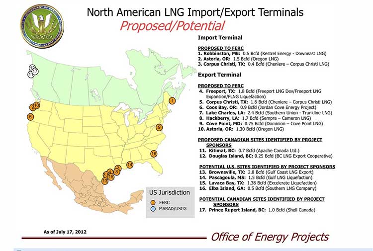
US FERC Map of LNG terminals in North America
Map from the United States Federal Energy Regulatory Commission showing LNG export terminal projects in North America (FERC)

What is it about the islands in Douglas Channel? First, Enbridge gets in to a lot of hot water, so to speak, for erasing the islands in Douglas Channel in an animation promoting the Northern Gateway Pipeline.  See for example The Vancouver Sun on back on Aug. 16, 2012, when it picked up a story from the Times Colonist – Enbridge map sinks islands, angers critics.   The controversial video segment showed Douglas Channel wide open for navigation, rather than marked with about one thousand square kilometres of mountainous islands. Map of Douglas Channel Islands from Leadnow.ca This map, created by the Leadnow.ca and  Sumofus.org websites was widely used by the media to show the difference.  Enbridge later amended its video with a disclaimer that it is “broadly representational.” A video by Shortt and Epic Productions “This is Not An Enbridge animation” showing the beauty of northwestern BC quickly went viral.

As this was happening, the United States government Federal Energy Regulatory Commission issued a map that shows Liquified Natural Gas import and export terminals across North America, a map that adds an island to the Channel–“Douglas Island.”

In fact, the map manages to get a lot about Canadian LNG projects wrong. It locates the BC LNG project on the non-existent Douglas Island. The company’s name Douglas Channel Energy Partnership actually gives the proper location this way

 south of the Moon Bay Marina, within the District of Kitimat and the asserted traditional territory of the Haisla Nation. The site is approximately 10 km southwest of Kitimat and 7 km north of Bees Cove Indian Reserve 6 (Bish Cove)

The small cove where BCLNG will put its barges to create the LNG is often locally called North Cove.

The FERC map also misplaces the Shell LNG project, now known as LNGCanada, in Prince Rupert, even though Shell confirmed the Kitimat location on May 15, 2012. It also calls it Prince Rupert Island, although the town of Prince Rupert is actually located on Kaien Island.

The map does apparently get the KM LNG project somewhat correct, attributing it to Apache Canada, but leaving off Apache’s partners, Encana and EOG.

The map recently also appeared on the website of Oregon Public Broadcasting in an article Five Keys To The Pacific Northwest’s Natural Gas Export Debate by reporter Amelia Templeton, which outlines the growing controversy over the plans to export US LNG through Coos Bay, Oregon via the Jordan Cove Project.

It appears that in Oregon, the Coos Bay LNG project is becoming as controversial as the Northern Gateway project is in Canada.

The issues outlined by Templeton include the threat of expropriation (called “eminent domain” in the US and also a key issue in the debate over the Keystone XL pipeline on the plains).  There are arguments on jobs versus the environment, especially the perceived threat to wild rivers and salmon spawning grounds. Finally one issue that is lower on the agenda in northwestern BC but a big worry in Oregon, the potential for a devastating earthquake along the Cascadia fault.

During the NEB hearings on the KM LNG (Apache/EOG/Encana) project in June, 2011, many of the  “expert” witnesses urged that that first Kitimat project go ahead quickly because of perceived competition from Oregon.

Unlike in Oregon, LNG projects are generally perceived positively in the northwest and all three are going ahead, although not as quickly as originally planned due to market volatility among prime potential customers in Asia.


How “On the Waterfront” could decide the fate of Enbridge’s Kitimat terminal

There’s one question about the Enbridge Northern Gateway project that many people ask and few can answer: Who is responsible for the port of Kitimat? Who would be liable should there be a disaster in the port? Nobody really knows.

Unlike many harbours in Canada, the port of Kitimat is “private,” although as the District of Kitimat says, “Transport Canada and other federal agencies continue to regulate navigation, security and environmental safety.” Kitimat has promoted that private status as an economic advantage.

If there’s a dispute, the question of responsibility and liability would probably end up in the Supreme Court of Canada, with the justices sorting out a historic puzzle. Or perhaps that historical puzzle could mean that the future of the port of Kitimat might be decided by the next B.C. provincial election.

Most of the other harbours in Canada are the responsibility of Ports Canada, a branch of Transport Canada or run by (usually not-for-profit) semi-public port corporations or local harbour commissions.

To find out why Kitimat is one of the few private ports in Canada, the first thing to do is watch Eliza Kazan and Bud Schulberg’s classic 1954 multiple Oscar winning movie, On the Waterfront, starring Marlon Brando, about how the mob ran the New York docks.

What has On the Waterfront got to do with Kitimat? It goes back to when the then Aluminum Company of Canada/Alcan (now Rio Tinto Alcan) was planning the Kitimat project; much of that work was done in New York both by employees and consultants. It was in 1949, that Malcolm Johnson, a New York Sun reporter, wrote a Pulitzer Prize winning series of investigative reports called “Crime on the Waterfront,” exposing corruption and Mafia involvement with the docks and the longshoremans’ union. The movie was based, in part, on that investigative series.

So in its planning, Alcan was determined that the longshore unions would not be involved in running the docks in Kitimat. The publicly stated reason has always been that Alcan wanted a seamless 24/7 operation that would be integrated with the aluminum smelter. Alcan would sign a collective agreement with the United Steelworkers that covered both the smelter and the docks. (CAW 2301 now represents most of the workers at the Kitimat smelter.)

When the Kitimat project was being finalized in 1949 and 1950 at the height of the Cold War, aluminum was a strategic commodity, security was high on the agenda, and it was not just the Soviet bloc but the mob as well that worried the authorities.

Add two factors. First, in 1949 the province of British Columbia was anxious to promote what would today be called a “mega-project.” Second, in the post-war era when corporations were relatively enlightened compared to today, Alcan was determined not to create the traditional “company town.”

To promote private-sector development of both hydro-electricity and aluminum, B.C. signed a rather loosely worded agreement with Alcan, noting that the project was going on “without investment by or risk to the government.” That agreement was implemented by the Legislative Assembly of B.C. by an equally wide open Industrial Development Act. One aim of both was try to ensure that future “socialists” would not expropriate the project.

Industrial township

With the province handing over the Crown land at the head of Douglas Channel at a very nominal price to Alcan, next came the creation of the District of Kitimat. With the town under construction, with few buildings and a small population, under normal B.C. practice, the area would be “unincorporated” and would not have a municipal government. But Alcan and the province came up with a new concept, which they called “an industrial township,” which would allow a municipal government to be established in anticipation of future growth.

The act that established the District of Kitimat put the boundaries outside the land owned by Alcan (excluding land reserved for the Haisla Nation).

Alcan began selling off the land in the planned areas of the town and other land it didn’t need. Individuals bought houses and businesses bought the land for their own use. Alcan retained ownership of the harbour and estuary lands and the small “Hospital Beach.”

The District of Kitimat has some legal responsibility for “wharfs” at the port of Kitimat. At council meetings, the environmental group, Douglas Channel Watch, has raised the question of the district’s responsibility and liability in case of an Enbridge incident but there’s been no definitive response from district staff. There is no municipal harbour commission as there is in other jurisdictions.

Up until recently, it was a convenient arrangement for everyone involved. Alcan, Eurocan and Methanex ran their dock operations without any interference, beyond standard Transport Canada oversight.

Things began to change in 2007, when the Rio Tinto Group bought Alcan, creating Rio Tinto Alcan. A couple of years ago, a senior staff source in the Canadian Auto Workers explained it to me it this way. “Alcan was a big corporation, but Alcan was a corporation with a big stake in Canada. As a union, we could do business with them. Rio Tinto is a transnational corporation with businesses in lots of countries but no stake in any of them. So it’s a lot harder now.”

With the Rio Tinto acquisition of Alcan, things tightened up in Kitimat. Negotiations between the District and RTA for the District to obtain more land stalled. Access to the estuary and other RTA lands that had been somewhat open under Alcan became more restrictive. In 2010, the Eurocan paper mill shut down along with its dock. In 2011, Rio Tinto bought the dock from West Fraser, owner of Eurocan. The Kitimat community noted that when the dock was repainted, it said just “Rio Tinto.” not “Rio Tinto Alcan” and that led to lots of gossip and wondering about what the Rio Tinto Group really plans for Kitimat. Last fall, Shell Canada purchased the former Methanex dock for part of its liquified natural gas operations.

With the Enbridge Northern Gateway project, the BC LNG project at North Cove and the KM LNG project at Bish Cove all along the shore of Douglas Channel and within the boundaries of the District of Kitimat which extends as far south as Jesse Lake, the question that has to be asked is, what happens now? If the Enbridge project is built, it will start just beyond the boundaries of the land owned by Rio Tinto Alcan.

That old arrangement between Alcan and the District of Kitimat is facing many new challenges.

The district once had a harbour master, but the position was eliminated because he had nothing to do. Alcan owned its docks, Alcan managed the docks and Alcan union employees worked on the docks. Later came the Eurocan (now owned by Rio Tinto) and Methanex (now owned by Shell) docks, again owned and operated by private corporations.

The District of Kitimat, nominally in charge, was content to sit back and collect taxes.

With the Enbridge Northern Gateway project, the B.C. LNG project at North Cove and the KM LNG project at Bish Cove all along the shore of Douglas Channel and within the boundaries of the District of Kitimat, the question that has to be asked is, what happens now? If the Enbridge project is built, it will start just beyond the boundaries of the land owned by Rio Tinto Alcan.

In Canada, ports and harbours are normally under federal jurisdiction and Transport Canada has oversight. But Alcan’s “private port” and the District of Kitimat were created by acts passed by the B.C. government.

The original agreement between the province and Alcan mentions an “aluminum plant” and “low-cost electrical power,” it doesn’t mention bitumen or liquified natural gas. Those provincial acts do not cover bitumen, supertankers and liquified natural gas.

B.C. Opposition Leader Adrian Dix has made it clear that his New Democratic Party opposes the Northern Gateway project. The federal government has said the province can’t really do anything to stop Enbridge Northern Gateway once Stephen Harper has decided that the pipeline project is in the national interest.

At this moment, Dix is a “contender” for the premiership, with Christy Clark and the B.C. Liberals dropping in the polls and with key members of her government deciding not to run in the election next spring.

So, if, as expected, Adrian Dix becomes the next B.C. premier, he has one very strong hand to play. Any act can, with proper legal advice, be amended by the B.C. legislature. That means the “socialists” so feared by Alcan and the premier of the day, Byron “Boss” Johnson, could alter the 1949 law. That in turn may upset the decades-old arrangement that created the private port which Enbridge is banking on.

Water, not oil, is the hot issue this summer in Kitimat

Kitimat's "Hospital Beach" on March 17, 2012, with the construction at the Rio Tinto Alcan plant in the background, before the area was closed to the public. (Robin Rowland) (Robin Rowland)
Kitimat’s “Hospital Beach” on March 17, 2012, with the construction at the Rio Tinto Alcan plant in the background, before the area was closed to the public. (Robin Rowland)


The hottest issue in Kitimat this summer is water, not oil. For us, this summer can be summed up by saying: “Water, water everywhere, but you can’t get there from here.”

Even with David Black’s proposal for an oil refinery on a hill 25 kilometres north of Kitimat, residents here know that the Enbridge Northern Gateway debate has gone on for years and will go on for many years to come.

As environmentalists worldwide celebrate the beauty of Douglas Channel, and decry the dangers that tanker traffic could pose to the channel, many people in Kitimat are cut off from the waterfront.

At the District of Kitimat Council meeting on August 7, Coun. Mario Feldhoff introduced a motion calling for a study in an effort to find ways to launch kayaks into the ocean. Yes that’s right, according to members of council, you can’t even drop a kayak into the waters of Douglas Channel unless you pay the kind marina a launch fee usually charged for larger fishing boats. Kitimat is down to only one expensive boat launch.

In 2010, there were three marinas in Kitimat: one privately operated at a place called Moon Bay, a large marina owned by the Kitimat Stikine Regional District at MK Bay and a small marina at Minette Bay, also the site of a log export operation. There was also a boat launch on land known as “Alcan beach” or “Hospital Beach” on property owned by Rio Tinto Alcan (RTA) near the aluminum smelter. Hospital Beach is the only beach in Kitimat (named because it is on the site of the town’s original hospital in the 1950s). Moon Bay was located on land owned by RTA, and in April 2010, it ordered the marina shut down.

According to RTA spokesperson Colleen Nyce, that was largely due to concerns about how the marina was being operated.

Some people who moored their boats at Moon Bay moved to MK Bay (if there was room). Others hauled their boats out of the water and parked them in their driveways. In the ensuing two years, there have been increasing stories about mismanagement at MK Bay and complaints about moorageand launching fees that are much higher than elsewhere in the province.

This spring, citing construction at the smelter, RTA closed public access to Hospital Beach for picnics, kids’ play and just looking at the water. That meant the boat launch was also off-limits. RTA spokesperson Nyce said:

The Rio Tinto Alcan site is now a full fledged construction zone with constant vehicular and heavy duty construction traffic. To that end, and as Rio Tinto Alcan representatives have always said, during construction we will take necessary steps to eliminate potential hazards to the general public on our road including access to Hospital Beach. Therefore, Hospital Beach will be closed to the public until construction is complete or until we believe it is more safe for public access.

Before access was closed, if a Kitimat resident was driving to Hospital Beach, they pass what was once a rough logging road that snaked its way along the shores of Douglas Channel toward Bish Cove. Now Bish Cove is the site of the Kitimat LNG project terminal. As part of the construction process, KM LNG upgraded the road. However, as the pace of construction increases KM LNG is now limiting access to the road and its views of the channel.

Why is there no access to the waterfront, or for that matter to the magnificent Kitimat River estuary?

It goes back to 1950 when the province of B.C., in a loosely worded agreement with what was then Alcan and in an equally non-specific Industrial Development Act, handed over the land where Kitimat is now to the company.

That included almost all the waterfront and the estuary. On the estuary, there is one small area of land that is a reserve for the Haisla Nation and one small area not in RTA domain owned by the District of Kitimat — but there is no right of way through a potential private development. Over the years, and especially since Rio Tinto took over Alcan, there have been more and more restrictions placed on access to Kitimat’s waterfront.

Restricted access has become such an important issue that it came up during the National Energy Board hearings on the Kitimat LNG project and was part of the NEB ruling granting KM LNG its export licence. Access to Kitimat’s waterfront is also a factor in the Enbridge Northern Gateway project, although that part is lost in all the bigger issues.

The fact that you can’t get to the waterfront and the estuary are a problem not only for community recreation; the inability for a resident or visitor to launch a kayak or small boat into the channel, much less larger fishing or recreational vessels, has put the brake on expansion of Kitimat’s already lucrative fishing, guiding and boating services.

There is already a lot of skepticism in Kitimat — due to the boom and bust of the industrial cycle — about all those promises of jobs and prosperity from industrial development. Restricted access to the ocean means that despite the growing number of jobs in Kitimat, corporate policy makes it hard to enjoy the benefits of living on the Douglas Channel.

It is the kind of externality that is always ignored by economists and is totally irrelevant to those business writers who claim to be experts in Kitimat but who have never been within 1,000 kilometres of the town.

You look out your window at the mountains and ocean of Douglas Channel and ask why can’t the residents and tourists go to the beach? That could be a key issue in the Enbridge Northern Gateway debate.