Did the 1964 tsunami bring a dangerous tropical fungus to the BC Coast?

In 1999, a tropical fungus called by scientists Cryptococcus gattii unexpectedly appeared on Vancouver Island. Spores from the fungus can cause a sometimes fatal pneumonia-like illness in humans, cats, dogs and marine mammals, including porpoises and dolphins. There is one reported case of the fungus infecting a great blue heron.

Normally, the fungus is most common in Papua New Guinea, Australia and South America. Today it is also found growing in the coastal forests and shoreline areas of southern coastal British Columbia, Washington and Oregon.

A study, released today, supported by the US Centres for Disease Control and Prevention (CDC) is described as tracking multiple pieces of a puzzle. It suggests that a singular event, like a natural disaster, could have been the missing piece that brought the whole picture together.

The scientists, microbiologist Arturo Casadevall, MD, PhD, Chair of Molecular Microbiology and Immunology at the Bloomberg School at Johns Hopkins University, and epidemiologist David Engelthaler, PhD, of the Translational Genomics Research Institute, Flagstaff, Arizona, suggest that a series of events brought the fungus to BC culminating in its possible spread by the tsunami unleashed by the 1964 magnitude 9.2 earthquake in Anchorage, Alaska. The scientists wrote that the tsunami idea seemed to fit the “when, where, and why” of this disease emergence.

The US CDC has tracked more than 300 C. gattii fungal infections in the Canadian and U.S. Pacific Northwest region since the first case on Vancouver Island in 1999. Prior to that time, infections with this fungus had been confined almost entirely to Papua New Guinea, Australia, and South America. The fungus typically infects people through inhalation. It can cause a pneumonia-like illness, and may also spread to the brain, causing a potentially fatal meningoencephalitis. Although the disease is fairly rare and few infected people become ill, for those who become infected, published case reports suggest an overall mortality rate of more than 10 percent.
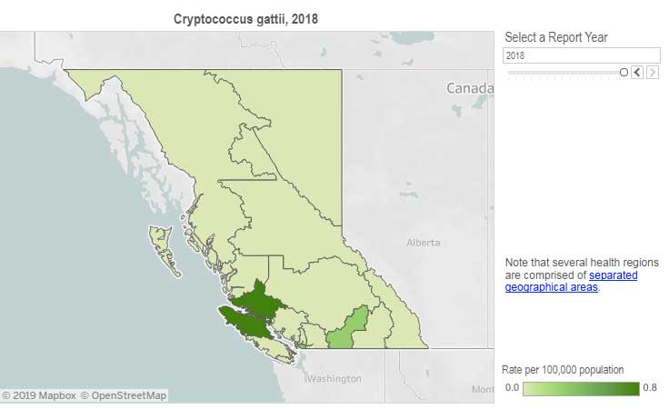
Incidence of Cryptococcus gattii infection in BC (BCCDC)

The British Columbia Centre for Disease Control (BCCDC) says Vancouver Island has one of the highest rates of infection in the world. Each year in B.C. from 10 to 25 people become sick from cryptococcosis and about 16 per cent die from the disease.

In the Northern Health region, however, only one case, in 2017, has been reported since 2009 and that was in the Northern Interior region.
The BCDC says the fungal infection can take several months to incubate after exposure. Only a few people exposed to the spores will become ill. Cryptococcus gattii is a reportable disease in British Columbia.

The new study is suggesting that the fungus first traveled in ships’ ballast tanks. After the Panama Canal opened in 1914, shipping increased significantly between Atlantic and Pacific ports.

The scientists believe that in South America, the fungus began washing from local rivers into shore waters. Then ships loaded ballast water, which research has shown is a common mode of transport for invasive species. The ballast water then spread the fungus to North American waters. Ships in those days routinely took on such ballast water in one port and simply discharged it, without treatment, in another.

How the tropical pathogen established itself in such a cool northern area was originally unclear. Theories have included global warming and the import of tropical eucalyptus trees.

The new study proposes that once in the North Pacific the fungus went unnoticed until the 1964 earthquake brought the fungus widely ashore and into coastal forest area.

It then took several decades for the fungus to evolve in its new habitat so that it could survive and then thrive first in coastal Vancouver Island, then across the island to the Lower Mainland and down to Washington and Oregon.

Casadevall says, “The big new idea here is that tsunamis may be a significant mechanism by which pathogens spread from oceans and estuarial rivers onto land and then eventually to wildlife and humans, If this hypothesis is correct, then we may eventually see similar outbreaks of C. gattii, or similar fungi, in areas inundated by the 2004 Indonesian tsunami and 2011 Japanese tsunami.”

The Alaskan Earthquake was felt as far as 4,500 kilometres away. Effects were recorded on the Hawaiian Islands. The waves reported in nearby Shoup Bay, Alaska were 67 metres causing significant shoreline devastation. At Seward, Alaska, the tsunami wave was 9.2 metres. At Port Alberni it was 6.4 metres. North of Kitimat, at Ketchikan, the wave was just 0.6 metres and at Prince Rupert, 1.4 metres. There are no figures for Kitimat, but with no damage reported, it is likely that the wave was somewhere around a metre.

The tsunami continued south, affecting much of the coastline of western North America, even causing several deaths on the beaches of northern California.

Several hours after the earthquake, multiple waves flowed up Alberni Inlet, cresting at eight metres and striking the Port Alberni region, washing away 55 homes and damaging nearly 400 others

The study retrieved multiple fungus samples from the forests in the Port Alberni region. Studies show there are multiple infected sea mammals in the port’s waterways. Human and terrestrial and marine animal cases have also been reported along the western coast of Vancouver Island. The results suggest that the contamination of the Port Alberni region may be from the 1964 tsunami rather than from terrestrial dispersal from the eastern side of Vancouver Island.
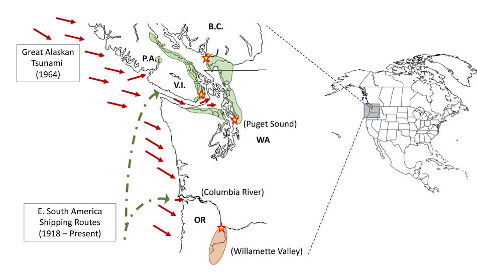
Map showing where the 1964 tsunami could have deposited the fungus (Ecological and Evolutionary Science)

The early environmental analyses in British Columbia identified that the fungus was found in soils and trees in the coastal Douglas fir forests and in coastal Western Hemlock forests bordering the coastal Douglas fir forest. While these studies were “limited in geographical space” the contaminated landscapes were also the known locations of human and animal infections. Further ecological analyses have identified higher levels of soil and tree contamination at low-lying elevations close to sea level.

The researchers now hope to continue testing their hypothesis with detailed analyses of C. gattii in soils within and outside tsunami-inundated areas of the Pacific Northwest. They then want to compare the British Columbia fungus with DNA collected from other parts of the world.–to see if the same C. gattii subtypes found in Brazil and the Pacific Northwest are more widely present in seawaters around ports.

The paper: “On the emergence of Cryptococcus gattii in the Pacific Northwest: ballast tanks, tsunamis and black swans” by David Engelthaler and Arturo Casadevall is in the journal Ecological and Evolutionary Science

BCDC defintion
Cryptococcus is a tiny (microscopic) yeast-like fungus. A species of this fungus, called Cryptococcus gattii, has been living on trees and in the soil on the east coast of Vancouver Island since at least 1999. More recently it has also been found in the Vancouver Coastal and Fraser Health regions. Infrequently, people and animals (e.g. cats, dogs, llamas, porpoises) exposed to this fungus become sick with cryptococcal disease (or cryptococcosis). Cryptococcosis can affect the lungs (pneumonia) and nervous system (meningitis) in humans. It affects people with healthy and weakened immune system. In rare cases, this disease can be fatal.

Many people will be exposed to the fungus sometime during their lives and most of these will not get sick. In people who become ill, symptoms appear many months after exposure.

Symptoms of cryptococcal disease include:

Prolonged cough (lasting weeks or months)
Shortness of breath
Headache
Vomiting
Fever
Weight loss
If symptoms occur, the disease can cause pneumonia, meningitis, nodules in the lungs or brain, or skin infection.

People are advised to see their doctor if they live in or visit an area where the fungus can be found and experience these symptoms.
EXCLUSIVE: Kitimat can regulate access to river camping, province indicates


 THE RIVERBANK PAPERS: After the flash flood on September 11, 2017, Northwest Coast Energy News filed Freedom of Information/Access to Information requests with a number of provincial and federal agencies who have jurisdiction over the Kitimat river and riverbank camping.
The first response to the FOI request is from the Ministry of Forest, Lands and Natural Resource Operations & Rural Development.

A preliminary assessment by the British Columbia  Ministry of Forest, Lands and Natural Resource Operations & Rural Development indicates that the District of Kitimat can regulate access to camping on the Kitimat River bank because although the shoreline is on Crown Land, the camping area is within the boundaries of the District.

One of the possible policies that the District staff is considering is allowing only “day access” to the riverbank.

An email on October 11, from Liz Williamson, a senior policy analyst in the ministry’s Land Tenure Branch to Gwen Sewell, the District’s Director of Planning and Community Development,  reads:

Permission does not apply to Crown Land within a municipality—as a result even in the absence of zoning/bylaws, any camping that does occur is technically in non-compliance  with the permission and therefore could be subject to enforcement action under the Land Act.

Williamson notes that the province likely will have to be involved.

Ultimately that does rely on provincial resources and it looks like DOK would want a greater role in the use and ability to locally enforce the use as you have mentioned zoning and associated bylaws would likely be a course of action you could consider.

Williamson went on to write:

I’m waiting to hear back from one of my more experienced colleagues but I am not aware of any specific limitation to DOK creating bylaws to regulate public recreational use of vacant Provincial land within the municipal boundaries, so long as it doesn’t conflict with a government interest.

She added that the laws and regulations are complex and advised the District to get legal advice. Then she added the District should have “upfront discussions with appropriate provincial authority to ensure that the bylaws do not conflict with existing policy/legislation or other agency interests.”

On September 19 the District voted to create a “working group” on riverbank access that is now being put together.

Right after the flash flood both Sewell and District of Kitimat Chief Administrative Officer, Warren Waycheshen, exchanged emails with officials of both the Ministry of Lands and Forests and the Ministry of the Environment asking first if the province would have any objections to a proposed plan to put gates on municipal land to limit access to the riverbank. Council later put the gate plan on hold.

The emails quoted provincial land use permission policy that says

“Crown permission to use land requires the activity must abide by and comply with all applicable, regulations and bylaws.

And

Before any person may rely on the Permission they must ensure that the activity is taking place on unencumbered Crown land. The Crown land must not be within

  • A Protected Area includes Ecological Reserves, Parks and Conservancies
  • Municipality

In his email to Cam Bentley, Resource Manager for the Skeena Lands district, Waycheshen asked if the province was interested in some form of joint administration of the riverbank and if the ministry was interested in joining the working group.

Sewell sent a similar email to Williamson noting,

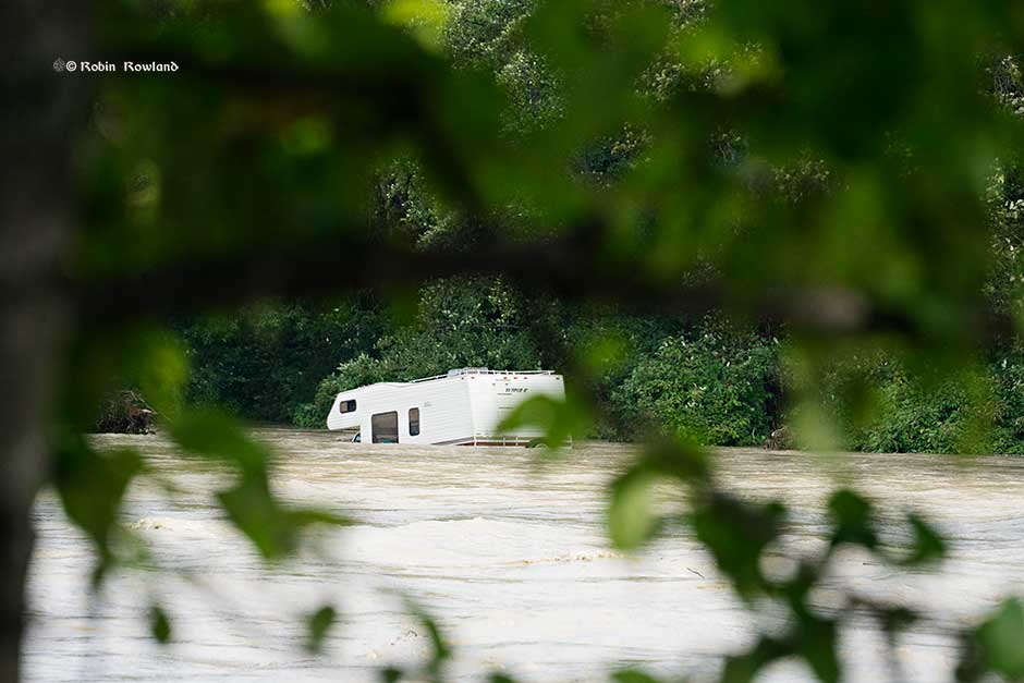
Camping has been occupying the banks of the Kitimat River—opposite a municipal campground called Radley Park—for decades….This had been a somewhat divisive local issue (it’s no cost and traditional use, grey water, residual garbage, human waste, blocking river access for day users etc. and there is a new willingness to consider regulation or prohibition of camping following a flash flood that required a dangerous multi-force rescue effort to save 14 campers and resulted in significant property loss (RVs, vehicles and camping equipment). As camping is “unregulated” the first responders had no idea how many people were in danger or where to look for campers.

Sewell went on to say:

Given…municipal authority to regulate land use by zoning, I believe Kitimat Council may use their zoning power to limit all or selected land along the Kitimat River to “day use only.” I am far from certain this will be the course of action Council will choose to pursue. For now, we only want to identify possibilities.

RELATED July 2015

Keremeos mayor wants province to stop campers who are leaving trash, human waste on riverbed:CBC

Williamson replied to Sewell saying that it was good there was no loss of life in the flood. She noted the Keremeos had been going through a similar  situation but that village’s problem was that, unlike the District of Kitimat, the camping was outside the municipal boundaries of the village.

KEEP THE RIVERBANK PAPERS INVESTIGATION GOING. 

These days filing Freedom of Information and Access to Information requests is much more expensive than it was in the past. It is part of obstruction of freedom of information by all levels of government.  One agency wants $900 for their files on the Kitimat River camping issue. That is currently under appeal.  Donations (see right hand column) will help the residents of Kitimat know more about what is happening on the camping issue.


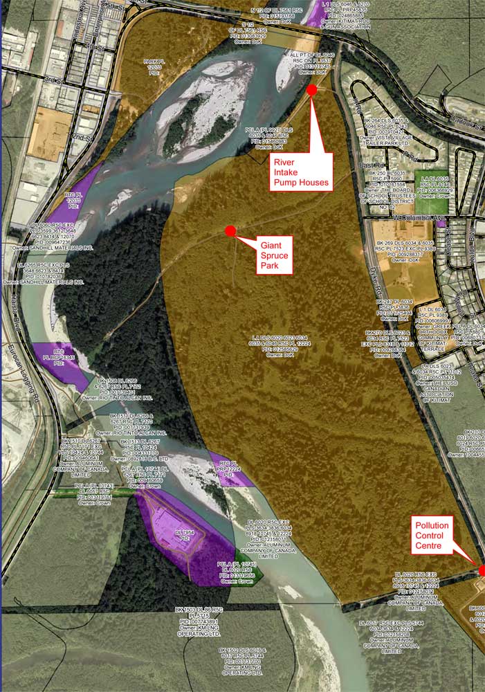
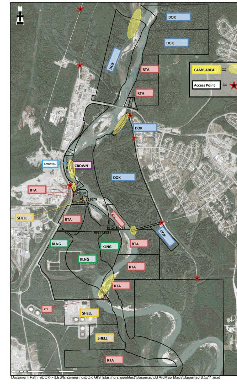
Map showing the various jurisdictions along the Kitimat River that the District submitted to the province (District of Kitimat via BC FOI)

Council votes to create “working group” on riverbank issues, tables plan to gate access

District of Kitimat Council voted Monday five to two to create a “working group” of “concerned citizens and community groups” to consider the future of riverbank camping along the Kitimat river. The working group will consider issues such as access to the river, pollution and how to control extended camping along the river.

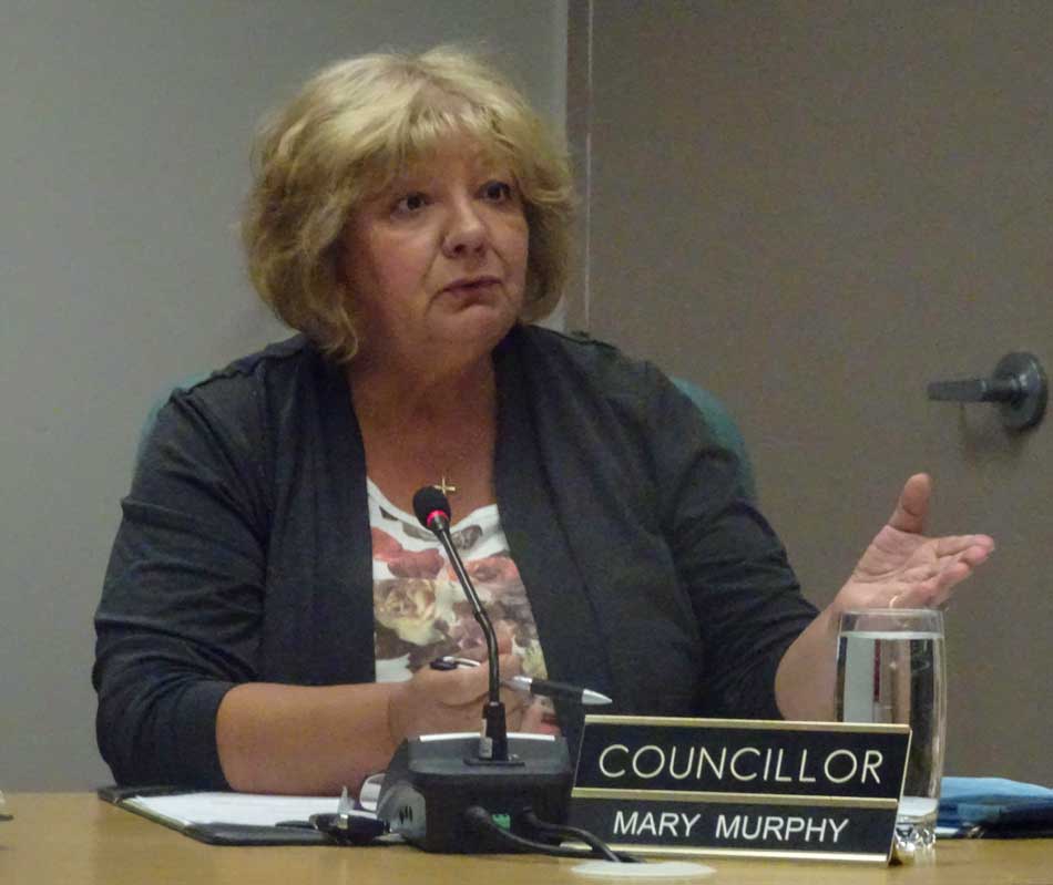
That vote came after council split five to two  again to defeat a motion by Councillor Mary Murphy to stop riverside camping altogether.

A proposal from District staff to put access gates at three locations, the Giant Spruce Road, the Sewage Plant and the Pump House was tabled for the time being. However, the councilors and staff marked the pump house gate as a priority for study by the engineering staff due to concerns that “the risk of fuel, oil and other contaminants (i.e. Illegal dumping ) occurring. This is the source water area for the city’s water supply, reducing access reduces contamination risks.” Staff said that unlike other portions of the riverbank, the District does “have authority under drinking water protection act to protect this area.”

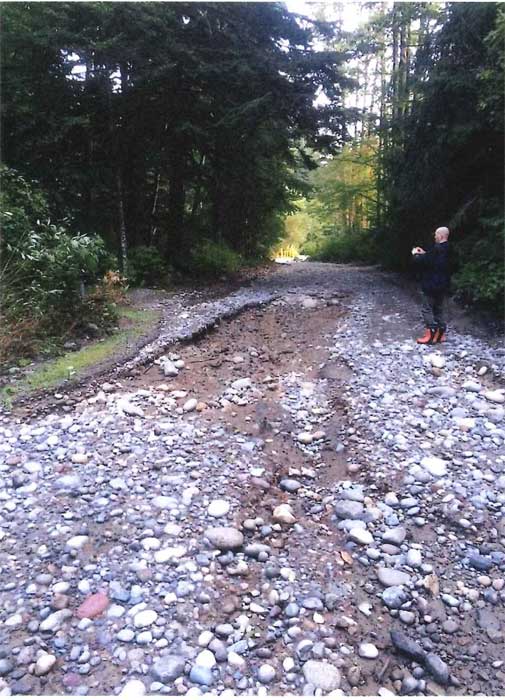
Council also voted to close Hirsh Creek park immediately because the roads at the camping area were washed out by the flood last week.

Councillors noted that many people still go to Hirsch Creek after the gates are closed at the end of the season to walk dogs or hike. This results in a parking jam at the front of the gate and on busy times, cars park on Highway 37 which could endanger pedestrians.

District staff will study moving the park gate down further to a point that the road narrows near the first campsite to allow safe access for dog walkers and hikers.

The main problem facing the District of Kitimat is that most popular sites along the riverbank for campers are on provincially owned Crown land. In 2014, the former BC Liberal government passed a regulation that says people can camp on Crown land for up to 14 days. As some councillors pointed out this restriction regularly abused by some campers who stay on the riverbank for weeks, some apparently camping from Victoria Day to Labour Day.

A detail from the DoK map of who owns the riverbank shows that many of the popular camping sports along the Kitimat River are on provincial Crown land (dark green) while the municipality controls the land away from the riverbank including the access roads (brown). (District of Kitimat)

During the debate it was pointed out that often those camp on the riverbank like to “claim” a camping/fishing spot and try to prevent others from using it. “I know of a couple of fistfights,” Murphy told Council.

As Councillor Rob Goffinet pointed out, whether or not the District could place gates on municipal land to stop access to provincial Crown land would require a legal opinion.

Murphy told Council that she had received emails, blaming Kitimat for “almost drowning” some of the campers. She said that her views may be unpopular among some residents, but added, “I don’t care if I’m unpopular, I want to keep people safe.”

Councillor Larry Walker, who pointed out that he likes of fish along the river, who supported Murphy’s motion told his colleagues to get their act together and “do something about the riverbank.” He later proposed that if council does nothing, perhaps Kitimat should hold a referendum on the future use of the river bank.

The majority on Council were more cautious, while acknowledging problems. They pointed out that the many of the campers both on the east bank and on the west bank at Radley Park patronize local businesses during the summer months.

While there was wide discussion on social media before the council meeting, only three people showed up to give their opinions, mostly concerned about permitting access to the river for people with mobility issues or small children.

There were many comments and questions about how other areas police provincial Crown Land, with some saying that some places restrict access to only a couple of days. However, no one either on Council or staff had any idea of what exactly other locations are doing, if anything.

There were no details of how the working group would operate and who would participate. During the debate it was pointed out that as well as the province, participants would have to include Rio Tinto, LNG Canada and DFO. As well, Council did not set a deadline for the working group to report back.

As Murphy pointed out back in 2014, Fisheries and Oceans refused to attend a Council meeting or make a public presentations on its views of the river bank situation. (DFO snubs District of Kitimat Council for a second time )  while offering to meet with staff “they will continue to meet at an operational level to provide information on DFO’s regulatory role.”  That, of course came during the Stephen Harper administration which severely restricted any public participation by the civil service on environmental issues. Whether the Justin Trudeau government has changed that policy remains to be seen.

The campsite road at Hirsch Creek park was washed out in the flood. (District of Kitimat)

Was the rain storm an anomoly?

During the debate, Mayor Phil Germuth, pointed to the sudden onslaught of rain during Sunday and Monday September 10 and 11 and called it “an anomaly” which means that Kitimat should not overreact to the storm.

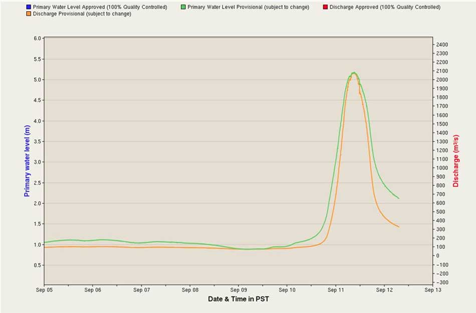
Environment Canada chart of the spike in the Kitimat River levels, as presented to District Council. (Environment Canada)

However, as The New York Times pointed out after Hurricane Harvey hit Texas, scientists have been warning for years that

Climate science has repeatedly shown that global warming is increasing the odds of extreme precipitation and storm surge flooding. Refusing to acknowledge this impairs our ability to prepare for future extreme weather and endangers American lives and property.

And another opinion article in the Times during Hurricane Harvey noted:

Scientists can now even evaluate how much climate change has increased the odds of individual extreme events, including rainfall and flooding.

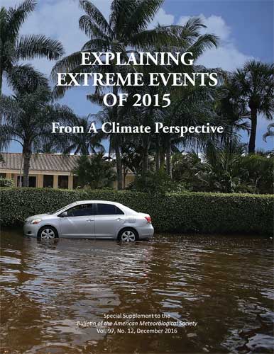
As the 2015 American Meteorological Society report quoted by The Times indicates, those  unpredictable and extreme events don’t just include floods but the widespread forest fires in Alaska in 2014 and we all know how bad the fire season has been in British Columbia this year.

Report on extreme weather events

As Noah Diffenbaugh  of Standford University pointed out in The Times

Being smart about managing exposure and vulnerability is critical to reducing risks. But doing so requires acknowledging that global warming is happening, that humans are the primary cause and that the odds of catastrophes like Hurricane Harvey are increasing.

RCMP, Fire warn of continuing hazards after “unique” Kitimat River flood

Both the RCMP and Kitimat Fire and Rescue are warning residents to stay away from the Kitimat River until the high water recedes. As well there are likely new hazards from a possible change in the river’s path due to the high water and as well as from debris in Douglas Channel.

Both detachment commander Staff Sergeant James McLaren and Fire Chief Trent Bossance made a special presentation to District of Kitimat Council Monday night to bring council up to date on the events that began early Monday morning.

The riverbanks are still hazardous, McLaren told Council and he urged that everyone stay away for at least the next two days. Anyone going out to fish in the Kitimat Arm of Douglas Channel, may also face hazards from snags, logs and debris such as floating propane cans. Bossance told Council in reply to a question from Councillor Larry Walker.

As well, Bossance told Council that the sudden deluge that began on Sunday afternoon is “not typical at all like the regular October flooding” that may be seen on the river.

Environment Canada chart of the spike in the Kitimat River levels, as presented to District Council. (Environment Canada)

Bossance warned that due to the volume and speed of the water it is likely that some parts of the river bed and river course have changed, and that the sandbars and snag areas that people may be familiar with may have shifted.

The effects of the flood are being monitored by RCMP, Fire and Rescue, Conservation officers, Fisheries and Oceans and provincial environmental officials.

Bossance said that the consensus of those officials is that the flood situation is unique in the history of Kitimat. Environment Canada issued a severe rainfall warning at noon on Sunday.

Bossance told Council  that people who were able to leave the riverbank said that they were able to walk out at about one a.m.  By 2:30 am, the river had risen so rapidly—about four metres—that by then people were trapped and calling 911 for help. McLaren said the RCMP immediately asked for the assistance of Kitimat Search and Rescue, who then requested assistance from Terrace Swift Water Rescue. Those units rescued twelve people from the riverbank.

A helicopter was called in and rescued two people.  The helicopter then made a sweep of the river bank but found no one else in danger.

McLaren told Council that as of 7 pm Monday no one had been reported missing or overdue.

The number of flooded vehicles or vehicles swept into the river is not certain, McLaren said,  but the number is estimated between twelve and fourteen ranging from large recreational vehicles to cars.   A preliminary assessment by ICBC indicates that the damage or loss of  vehicles will be covered but that will have to be confirmed by the vehicle owners.

Bossance said that high tide was not that much of a factor since it occurred at 5:30 am. Most of the high water was runoff from the upper Kitimat River.

Of the fourteen people rescued two were Kitimat residents, the rest from out of town.  Emergency social services has assisted those needed to find housing.

The RCMP will continue increased patrols in the river area until the danger has passed.

Ocean acidification a threat to the Dungeness crab: NOAA study

With climate change, the oceans are becoming more acid and that is a threat to the dungeness crab, according to a study by the US National Oceanic and Atmospheric Administration.

The study says ocean acidification expected to accompany climate change may slow development and reduce survival of the larval stages of Dungeness crab.

The dungeness crab is a key component of the Northwest marine ecosystem and vital to fishery revenue from Oregon to Alaska.

The research by NOAA Fisheries’ Northwest Fisheries Science Center in Seattle indicates that the declining pH anticipated in Puget Sound could jeopardize populations of Dungeness crab and put the fishery at risk. The study was recently published in the journal Marine Biology.

Ocean acidification occurs as the ocean absorbs carbon dioxide from the combustion of fossil fuels. Average ocean surface pH is expected to drop to about 7.8 off the West Coast by 2050, and could drop further during coastal upwelling periods.

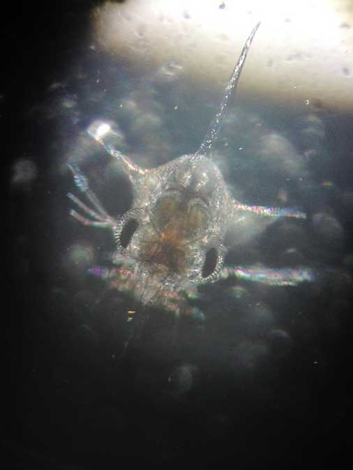
Survival of Dungeness crab larvae, called zoeae, declined at the lower pH levels expected with ocean acidification. (Jason Miller)
Survival of Dungeness crab larvae, called zoeae, declined at the lower pH levels expected with ocean acidification.
(Jason Miller)

Dungeness crab is the highest revenue fishery in Washington and Oregon, and the second most valuable in California, although the fishery was recently closed in some areas because of a harmful algal bloom. The Dungeness crab harvest in 2014 was worth more than $80 million in Washington, $48 million in Oregon and nearly $67 million in California

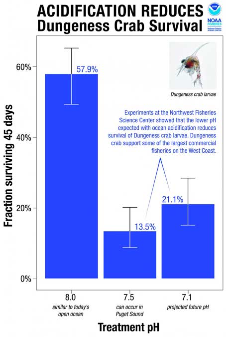
“I have great faith in the resiliency of nature, but I am concerned,” said Jason Miller, lead author of the research, which was part of his dissertation. “Crab larvae in our research were three times more likely to die when exposed to a pH that can already be found in Puget Sound, our own back yard, today.”

Scientists collected eggs from Dungeness crabs in Puget Sound and placed them in tanks at the NWFSC’s Montlake Research Laboratory. The tanks held seawater with a range of pH levels reflecting current conditions as well as the lower pH occasionally encountered in Puget Sound when deep water wells up near the surface. Larvae also went into tanks with the even lower-pH conditions expected with ocean acidification.
115757_webcrab
“The question was whether the lower pH we can expect to see in Puget Sound interferes with development of the next generation of Dungeness crab,” said Paul McElhany, a NOAA Fisheries research scientist and senior author of the paper. “Clearly the answer is yes. Now the question is, how does that play out in terms of affecting their life cycle and populations overall?”

Larvae hatched at the same rate regardless of pH, but those at lower pH took longer to hatch and progressed through their larval stages more slowly. Scientists suggested that the lower pH may reduce the metabolic rate of embryos. That could extend their vulnerable larval period, or could jeopardize the timing of their development in relation to key food sources, researchers suggested.

Larval survival also dropped by more than half at lower pH. At pH 8.0, roughly equivalent to seawater today, 58 percent of the crab larvae – called zoeae – survived for 45 days. At pH 7.5, which sometimes occurs in Puget Sound now, survival was 14 percent. At pH 7.1, which is expected to roughly approximate the pH of water upwelling on the West Coast with ocean acidification, zoeae survival remained low at 21 percent.

“Areas of greatest vulnerability will likely be where deep waters, naturally low in pH, meet acidified surface waters,” such as areas of coastal upwelling along the West Coast and in estuary environments such Hood Canal, the new study predicts.


BC launching major study of Kitimat River, Kitimat Arm water quality

The Environmental Protection Division of BC’s Ministry of Environment is launching a major study of the water quality in the Kitimat valley, first on the Kitimat River and some of its tributaries and later on the Kitimat Arm of Douglas Channel.

There has been no regular sampling by the province in Kitimat since 1995 (while other organizations such as the District of Kitimat have been sampling).

Jessica Penno, from the regional operations branch in Smithers, held a meeting for stakeholders at Riverlodge on Monday night. Among those attending the meeting were representatives of the District of Kitimat, the Haisla Nation Council, LNG Canada, Kitimat LNG, Rio Tinto BC Operations, Douglas Channel Watch, Kitimat Valley Naturalists and the Steelhead Society.

As the project ramps up during the spring and summer, the ministry will be looking for volunteers to take water samples to assist the study. The volunteers will be trained to take the samples and monitored to insure “sample integrity.” Penno also asked the District, the Haisla and the industries in the valley to collect extra samples for the provincial study and to  consider sharing historical data for the study.

With the growing possibility of new industrial development in the Kitimat valley, monitoring water quality is a “high priority” for the province, Penno told the meeting. However, so far, there is no money targeted specifically for the project, she said.

Fishing and camping on the Kitimat River
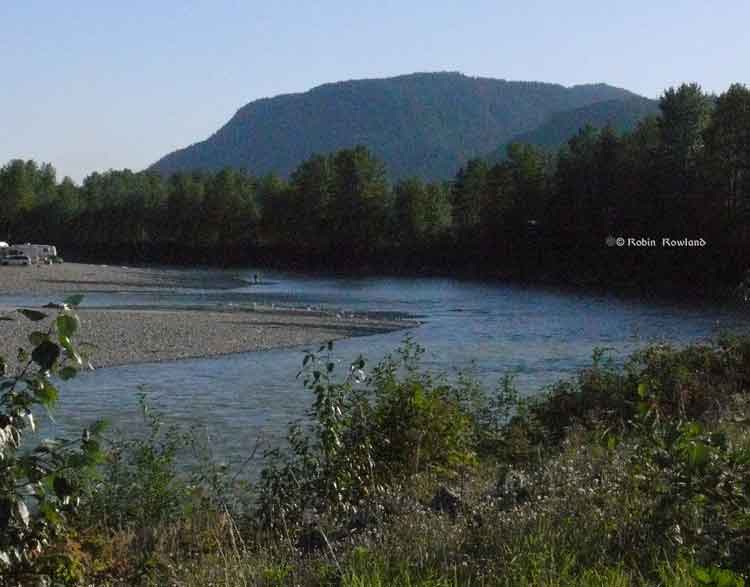
Camping and fishing on the Kitimat River. (Robin Rowland/Northwest Coast Energy News)

The purpose of the study is to make sure water in the Kitimat valley meet the provinces water quality objectives, which have the aim of watching for degradation of water quality, upgrade existing water quality or protect for designated uses such as drinking water, wildlife use, recreational use and industrial water supplies as well as protecting the most sensitive areas. It also provides a baseline for current and future environmental assessment. (In most cases, testing water quality for drinking water is the responsibility of the municipalities, Penno said.  The province may warn a municipality if it detects potential problems, for example if a landslide increases metal content in a stream).

Under the BC Environment system, “water quality guidelines” are generic, while “water quality objectives” are site specific.

One of the aims is to compile all the studies done of the Kitimat River estuary by the various environmental impact studies done by industrial proponents.

The ministry would then create a monitoring program that could be effectively shared with all stakeholders.

At one point one member of the audience said he was “somewhat mystified” at the role of Fisheries and Oceans in any monitoring, noting that “when you phone them, nobody answers.”

“You mean, you too?” one of the BC officials quipped as the room laughed.

Water quality objectives

The last time water quality objectives were identified for the Kitimat River and arm were in the late 1980s, Penno told the meeting. The objectives were developed by the British Columbia government because of potential conflict between fisheries and industry at that time. The objectives were developed for the last ten kilometres of the Kitimat River and the immediate area around the estuary and the Kitimat Arm. “The Kitimat is one of the most heavily sport fished rivers in Canada,” she said.

However, the work at that time was only provisional and there was not enough water quality monitoring to create objectives that could be approved by the assistant deputy minister.

There has been no monitoring of the Kitimat River by BC Environment since 1995. “We’ve had a lot of changes in the Kitimat region, with the closure of Methanex and Eurocan, the modernization of Rio Tinto and potential LNG facilities.”

The main designated uses for the Kitimat River at that time were aquatic life, wildlife with secondary use for fishing and recreation.

She said she wants the stakeholders to identify areas that should be monitored at first on the river and the tributaries. Later in the summer, Environment BC will ask for suggestions for the estuaries of the Upper Kitimat Arm.

Participants expressed concern that the water supply to Kitamaat Village and the Kitimat LNG site at Bish Cove as well as Hirsch Creek and other tributaries should be included in the study. Penno replied that the purpose of the meeting was to identify “intimate local knowledge” to help the study proceed.

After a decade so of cuts, the government has “only so much capacity,” Penno said, which is why the study needs the help of both Kitimat residents and industry to both design the study and to do some of the sampling.

The original sampling station in the 1980s was at the Haisla Boulevard Bridge in Kitimat. A new sampling station has been added at the “orange” Kitimat River bridge on Highway 37. There is also regular sampling and monitoring at Hirsch Creek. The aim is to add new sampling points at both upstream and downstream from discharge points on the river.

The people at the meeting emphasized the program should take into consideration the Kitimat River and all its tributaries—if budget permits.

Spring freshette

Last year, the team collected five samples in thirty days in during four weeks in May and the first week in June, “catching the rising river quite perfectly” at previously established locations, at the Haisla Bridge and upstream and downstream from the old Eurocan site as well as the new “orange bridge” on the Kitimat River.

The plan calls for five samples in thirty days during the spring freshette and the fall rain and monthly sampling in between.

The stakeholders in the meeting told the enviroment staff that the Kitimat Valley has two spring freshettes, the first in March during the valley melt and later in May during the high mountain melt.

The plan calls for continued discussions with the industry stakeholders, Kitimat residents and the Haisla Nation.

The staff also wants the industrial stakeholders to provide data to the province, some of it going back to the founding of Kitimat if a way can be found to make sure all the data is compatible. One of the industry representatives pointed out, however, that sometimes data is the hands of contractors and the hiring company may not have full control over that data.

There will be another public meeting in the summer, once plans for sampling in the Kitimat Arm are ready.

Eel grass really a flower that stores more carbon than tropical forests, genome reveals

Eel grass is not a seaweed but a flowering plant that migrated to the sea, say scientists who have now mapped the eel grass genome. The study also shows that eel grass ( Zostera marina) is crucial in absorbing carbon dioxide in the soft sediments of the coasts.

Eel grasses form a carbon dioxide sink: “they store more carbon than tropical forests,” says Jeanine Olsen of the University of Groningen in the Netherlands who led the study.

Coastal sea grass ecosystems cover some 200,000 square kilometers, the study says. Those ecosystems account for an estimated 15 per cent of carbon fixed in global ocean, and also impact sulphur and nitrogen cycles.

The scientists argue that since sea grasses are the only flowering plants to have returned to the sea that is the most extreme adaptation a terrestrial (or even freshwater) species can undergo.

The science team says the Zostera marina genome is “an exceptional resource that supports a wide range of research themes, from the adaptation of marine ecosystems under climate warming and its role in carbon burial to unraveling the mechanisms of salinity tolerance that may further inform the assisted breeding of crop plants.”

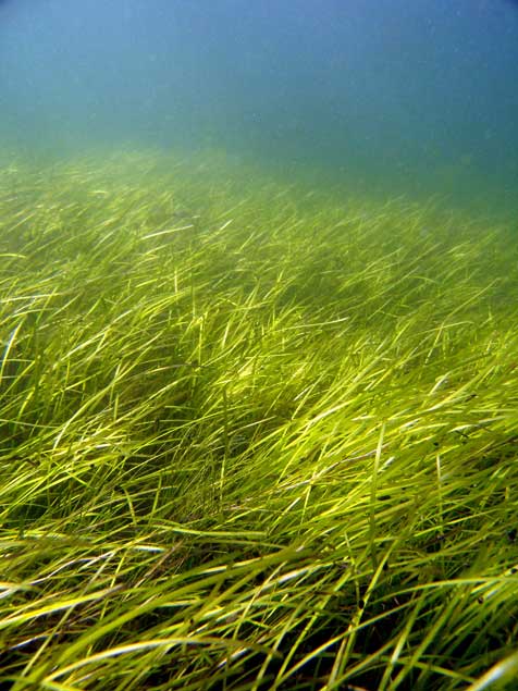
A seagrass meadow. (Christoffer Boström)
A seagrass meadow.
(Christoffer Boström)

Sea grasses form the backbone of one of the most productive and biodiverse ecosystems on Earth, rivaling coral reefs and rain forests in terms of the ecosystem services they provide to humans.

Sea grass meadows are part of the soft-sediment coastal ecosystems found in all continents, with the exception of Antarctica. They not only form a nursery for young fish and other organisms, but also protect the coastline from erosion and maintain water clarity. ‘

The study, which sequenced the genome of the eel grass taken from the Archipelago Sea off Finland. published today, in the journal Nature, is the work of an international consortium of 35 labs, most of them in Europe, working with researchers from the U.S. Department of Energy Joint Genome Institute.

The study showed that eel grasses are completely submerged marine flowering plants, called by science angiosperms. It shows that eel grass is a member of the ancient monocot family.

The monocots include about 60,000 species, flowering plants that first appear above the soil as a single leaf. They include orchids, “true grasses,” as well as rice, wheat, maize and “forage grasses” such as  sugar cane, and the bamboos. According to Wikipedia, other economically important monocot crops include  palms  bananas , gingers, onions, garlic, lilies, daffodils,  irises, amaryllis,  bluebells and tulips.

Zostera marina is the first marine flowering plant have its genome fully sequenced. As well as finding the eel grass’s genetic ancestors the researchers were interested in understanding how the plant–and by extension other plants in the ecosystem–adapt to climate change.

As it adapted to  an underwater, coastal lifestyle, eel grass gained genes that allowed it to live in saltwater but lost genes involved in traits associated with land-based plants.

Olsen called this “arguably the most extreme adaptation a terrestrial (and even a freshwater) species can undergo.”

What she describes as the “use it, lose it, or change it” scenario, eelgrass modified its cell walls. The eel grass cell wall is very different from normal plant cell walls and more like that of sea algae, similar to the cell in seaweeds. The eel grass has lost genes associated with light-sensing, pollination and regulation of internal water balance.

Eel grass lost its stomata (which are used by land plants to ‘breathe’) but also all of the genes involved in stomatal differentiation. “The genes have just gone, so there’s no way back to land for sea grass,” Olsen says. Sex is entirely underwater involving long naked sperm filaments especially adapted for underwater fertilization of the tiny flowers.

The team compared the eel grass genome to duck weed, one of the simplest flowering plants and Zostera marina’s closest sequenced relative. They noted differences in genes related to cell wall structure due to adaptations to freshwater or terrestrial conditions. For example, plants such as duckweed have seemingly lost genes that help plants retain water in the cell wall, while eel grass has regained these genes to better deal with osmotic stress at low tide.

“They have re-engineered themselves,” said Olsen of the changes affecting the eelgrass cell walls. “Crop breeders may benefit from lessons on how salt tolerance has evolved in these plants.”

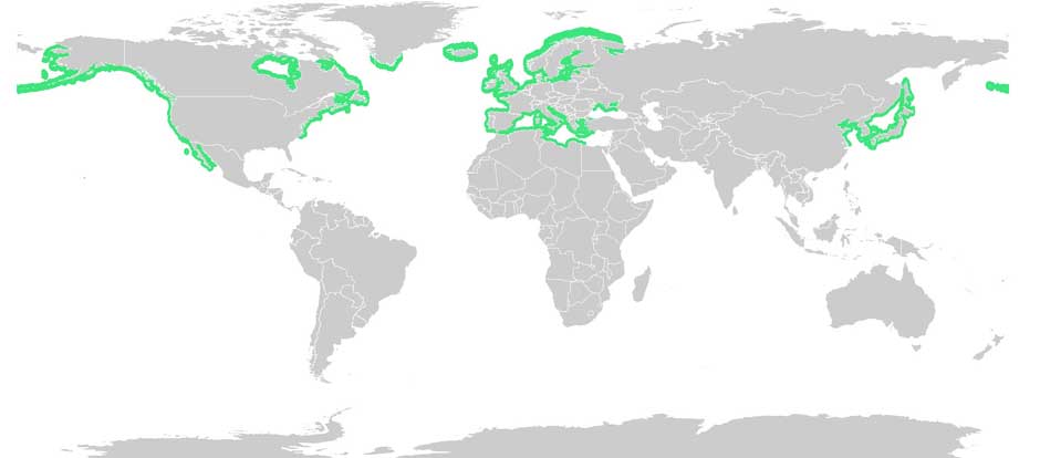
Eel grass distribution. (Wikipedia Commons(

With Zostera marina meadows stretching from Alaska to Baja California, and from the White Sea to southern Portugal, Olsen noted that these ecosystems afford researchers “a natural experiment to investigate rapid adaptation to warmer or colder waters, as well as to salinity tolerance, ocean acidification and light.”

Eel grass endangered

Jeremy Schmutz, head of the US Department of Energy’s genetic plant program, emphasized that while eel grasses are key players in coastal marine ecosystem functions and considered the “lungs of the sea,” they are also endangered. “There are estimates that nearly a third of the eel grass meadows worldwide have been destroyed by runoff into the ocean,” he said, “reducing their potential capabilities as carbon sinks. Thus, studying the adaptive capacity of eel grass is urgent to assist conservation efforts.”

An overarching question for Olsen’s team is how quickly eel grass can adapt to rapid climate change. The fact that Zostera marina grows along the coastline from Portugal to Scandinavia is being used as a natural experiment to investigate adaptation to warmer or colder water, as well as to salinity, ocean acidification and light.

Kitimat boil water advisory could last until the end of the week, District says it depends on river levels, rain

kitimatlogoThe District of Kitimat in an update on the boil water advisory says it could last until the end of the week. There is no immediate problem because the water is still being treated.

Kitimat Chief Administrative Officer Warren Waycheshen says the turbidity from the high water means that it is not possible to do a full sample on the safety of the water.   There are no delays due to the holiday weekend, the labs are open and ready, Waycheshen told Northwest Coast Energy News.

There  are no immediate dangers to Kitimat from the high water,  he said.

The District says:

October 11, 2015
The boil water advisory issued by the District of Kitimat will remain in place at this time. Until further notice, continue to boil water for 2 solid minutes before using it for cooking or drinking.

The District of Kitimat, with advice from Northern Health, will not consider terminating the advisory until two samples conclude there is not a health risk. Sampling is not expected to be complete until at least the end of the week of October 12, 2015 and could be longer if the rain continues.

The District is treating the water as usual. There is nothing to suggest contamination is occurring; however, as a precautionary measure please continue to boil water prior to use.

Turbidity in this case means high levels of particulate matter in the river, including sand and possibly salts.  Waycheshen said the Kitimat River rose four metres on Saturday, then dropped by about two metres overnight but with the later Sunday afternoon rain the river is rising once again.

The Environment Canada forecast issued at 4 pm Sunday, calls for rain for the next week.

Wind Warning continues

The Environment Canada wind warning for the north coast was continued this morning but there are currently no alerts in effect for Kitimat.

Wind warning in effect for:

North Coast – coastal sections
The third and final disturbance in this series of storms is moving onto the northern BC Coast. The front will cross the central coast tonight. Southeast winds up to 110 km/h will develop over Haida Gwaii near noon then spread to the North Coast – Coastal Sections and Central Coast – Coastal Sections this afternoon. Winds will shift to southwest with the passage of the front then diminish this evening.

Damage to buildings, such as to roof shingles and windows, may occur. High winds may toss loose objects or cause tree branches to break.

Wind warnings are issued when there is a significant risk of damaging winds.

Radley Park

Waycheshen says there probably has been some flood damage to Radley Park, but at this point  District staff are unable to get into the area to assess the damage.

“Very low levels” of Exxon Valdez oil threaten salmon and herring survival 25 years later

“Very low levels” of crude oil from the 1989 Exxon Valdez spill in Prince William Sound, Alaska, are a threat to the survival of herring and pink salmon that spawn in the region, according to a study released today by the US National Oceanic and Atmospheric Administration.

The study shows that embryonic salmon and herring exposed to very low levels of crude oil can develop hidden heart defects that compromise their later survival.

That means that the Exxon Valdez spill on March 24, 1989 may have had much greater impacts on spawning fish than previously recognized, according to the study published in  Nature’s online journal  Scientific Reports Very low embyronic crude oil exposures cause lasting defects in salmon and herring.

“These juvenile fish on the outside look completely normal, but their hearts are not functioning properly and that translates directly into reduced swimming ability and reduced survival,” said John Incardona, a research toxicologist at NOAA Fisheries’ Northwest Fisheries Science Center (NWFSC) in Seattle. “In terms of impacts to shore-spawning fish, the oil spill likely had a much bigger footprint than anyone realized.”

This is a juvenile pink salmon exposed to low levels of crude oil as an embryo. While these fish appear outwardly normal, they nevertheless developed heart defects that compromised their ability to swim. Fish that are less able to forage and avoid predators are much less likely to survive to adulthood. (NOAA)

Previous research has shown that crude oil disrupts the contraction of the fish heart muscle cells. Embryonic fish exposed to trace levels of crude oil grow into juveniles with abnormal hearts and reduced cardiorespiratory function.

“With this very early impact on the heart, you end up with an animal that just can’t pump blood through its body as well, which means it can’t swim as well to capture food, form schools, or migrate,” said Mark Carls, toxicologist at the Alaska Fisheries Science Center. “Crude oil is changing basic physiology, or what makes a fish a fish.”

The research builds on earlier work by the Auke Bay Laboratories, part of NOAA Fisheries’ Alaska Fisheries Science Center, which found much reduced survival of pink salmon exposed as embryos to polycyclic aromatic hydrocarbons (PAH) from crude oil.

“Our findings are changing the picture in terms of assessing the risk and the potential impacts of oil spills,” said Nat Scholz, leader of the NWFSC’s ecotoxicology program and a coauthor of the new study. “We now know the developing fish heart is exquisitely sensitive to crude oil toxicity, and that subtle changes in heart formation can have delayed but important consequences for first-year survival, which in turn determines the long-term abundance of wild fish populations.”

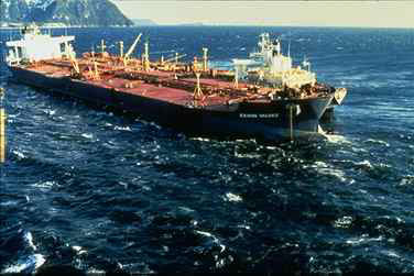
The Exxon Valdez aground on Bligh Reef in Prince William Sound in May 1989. (NOAA)
The Exxon Valdez aground on Bligh Reef in Prince William Sound in March 1989. (NOAA)

The Exxon Valdez spill was the largest in U.S. history, with extensive oiling of shoreline spawning habitats for Pacific herring and pink salmon, the two most important commercial fish species in Prince William Sound.

Herring larvae sampled in proximity to oil were visibly abnormal, and mortality rates were higher for pink salmon embryos at oil spill sites than unaffected regions.

The herring fishery collapsed three to four years after the spill, when the herring spawned in oiled areas reached reproductive maturity.

The paper notes that the contribution of the spill to the herring population collapse, if any, was never determined and remains controversial.

Other studies, however, tend to confirm the findings, including heart problems for fish exposed to the Gulf of Mexico Deepwater Horizon spill and even fish exposed to naturally occurring oil seeps.

Oil spill caused unexpected lethal impact on herring, study shows

Gulf oil spill caused heart defects in fish embryos new study finds

The new findings suggest that the delayed effects of the spill may have been important contributors to the declines.

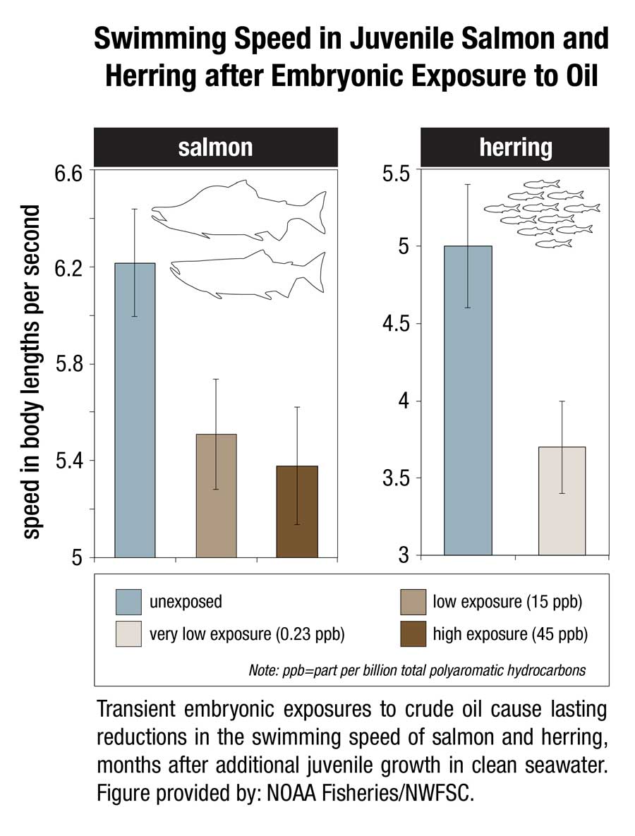
 This image shows transient embryonic exposures to crude oil cause lasting reductions in the swimming speed of salmon and herring, months after additional juvenile growth in clean seawater. (NOAA)

This image shows transient embryonic exposures to crude oil cause lasting reductions in the swimming speed of salmon and herring, months after additional juvenile growth in clean seawater. (NOAA)

Scientists from the Northwest Fisheries Science Center and Alaska Fisheries Science Center temporarily exposed embryonic salmon and herring to low levels of crude oil from the North Slope of Alaska and found that both absorbed chemicals at similar concentrations in their tissues. The embryos were then transferred to clean seawater and raised as juvenile fish for seven to eight months.

Few of the exposed embryos were outwardly abnormal in any way. However, closer examination of the fish revealed subtle defects that could reduce their long-term survival.

Juvenile salmon exposed to oil grew more slowly, with those exposed to the highest concentrations growing the slowest. For salmon, early survival in the ocean is strongly influenced by juvenile growth, with smaller fish suffering higher loss to predators.

Scientists used swimming speed as a measure of cardiorespiratory performance and found that fish exposed to the highest concentrations of oil swam the slowest. Slower swimming is an indication of reduced aerobic capacity and cardiac output, and likely makes fish easier targets for predators.

Exposure to oil as embryos altered the structural development of the hearts of juvenile fish, potentially reducing their fitness and swimming ability. Poor swimming and cardiac fitness is also a factor in disease resistance.

Earlier studies on the ecosystem-scale crash of the Prince William Sound herring population  several years after the Exxon Valdez spill were based on higher levels of exposure to the oil. The new study shows that that cardiac injury occurs in normal-appearing fish that survive even lower level exposures.

The scientists reviewed data on measured oil concentrations in surface water samples collected in Prince William Sound after the oil spill and during the 1989 herring spawning season. Most of the 233 samples contained less oil than was believed to be toxic to herring at the time, based on visible gross developmental abnormalities. However, nearly all of the samples contained oil at or above concentrations shown in the new study to alter heart development.

If the Exxon Valdez spill impacted heart development among a large majority of fish that were spawned in proximity to oiled shorelines, the subsequent losses of juveniles to delayed mortality would have left fewer adults to join the population. Although not direct proof, this provides a plausible explanation for the collapse of the Prince William Sound herring stock four years later, when fish spawned during the oil spill would have matured.

The study concludes that the impacts of the Exxon Valdez spill on near shore spawning populations of fish are likely to have been considerably underestimated in terms of both the geographic extent of affected habitat and the lingering toxicity of low levels of oil. The findings will likely contribute to more accurate assessments of the impacts of future oil spills, Incardona said. “Now we have a much better idea of what we should be looking for,” he said.

That means, according to the study “that the impacts of the Exxon Valdez oil spill on populations of near shore spawning fish are likely to have been considerably underestimated, in term of both the geographic extent of affected habitats and the lingering toxicity of low levels of residual oil.”

The report calls for more studies of the sensitivity of the developing fish heart since the vulnerability “also has implications for other pollution sources in marine ecosystems, including increasing maritime vessel traffic and expanding land-based urban runoff.”

In 2013, the Northern Gateway Joint Review panel said this about the Exxon Valdez  oil spill.

Scientific studies after the Exxon Valdez spill indicated that the vast majority of species recovered following the spill and that functioning ecosystems, similar to those existing pre-spill, were established.

Species for which recovery is not fully apparent, such as Pacific herring, killer whales, and pigeon guillemots, appear to have been affected by other environmental factors or human influences not associated with the oil spill. Insufficient pre-spill baseline data on these species contributed to difficulties in determining the extent of spill effects.

Based on the evidence, the Panel finds that natural recovery of the aquatic environment after an oil spill is likely to be the primary recovery mechanism, particularly for marine spills. Both freshwater and marine ecosystem recovery is further mitigated where cleanup is possible, effective, and beneficial to the environment.

Natural processes that degrade oil would begin immediately following a spill. Although residual oil could remain buried in sediments for years, the Panel finds that toxicity associated with that oil would decline over time and would not cause widespread, long-term impacts.

Related

25th anniversary of Exxon Valdez disaster looms over Northern Gateway dispute

Dilbit dangerous to young fish, laboratory study shows

Diluted bitumen, also known as dilbit, a mixture of oil sands bitumen and natural gas dilutants can seriously harm fish populations, according to research study at Queen’s University and the Royal Military College of Canada published this week.

At toxic concentrations, effects of dilbit on exposed fish included deformities and clear signs of genetic and physiological stress at hatch, plus abnormal or uninflated swim bladders, an internal gas-filled organ that allows fish to control their buoyancy. Exposure to dilbit reduces their rate of survival by impairing their ability to feed and to avoid predators.

Post-doctoral fellow Barry Madison works with the fish in Valerie Langlois' lab. (Queen's University)
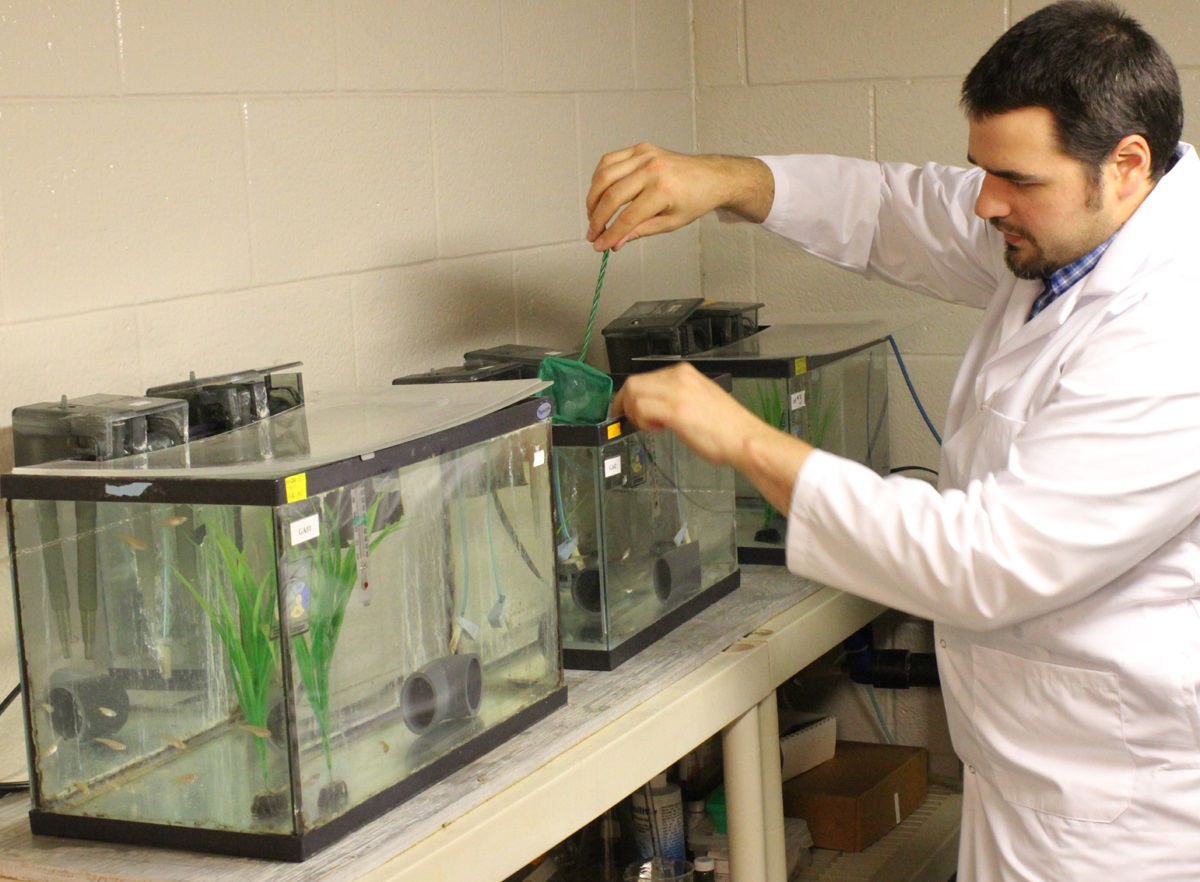
Post-doctoral fellow Barry Madison works with the fish in Valerie Langlois’ lab. (Queen’s University)

Among the other findings from the study were

    • Embryo toxicity of dilbit was comparable to that of conventional oils.
    • Developmental malformations increased with increasing dilbit concentrations.
    • Chemical dispersion broadened the genotoxic effects of dilbit

“This new study provides a clearer perspective on the potential risks to Canada’s aquatic resources of dilbit spills, and a technical basis for decisions on dilbit transportation within Canada,” says Peter Hodson Environment Studies, Biology at Queens. “It reduces some of the uncertainty and unknowns about the hazards of dilbit.”

This study characterized the toxicity and physiological effects of unweathered diluted bitumen (Access Western Blend dilbit; AWB) to a fish used for laboratory studies. Embryos of Japanese medaka (Oryzias latipes) were exposed for 17 days to dilutions of dilbit physically-dispersed by water and chemically-dispersed by dispersants

AWB dilbit exposure was not lethal to medaka, but resulted in a high prevalence of blue sac disease (BSD), impaired development, and abnormal or un-inflated swim bladders. Blue sac is a disease of young trout and other salmonid species; usually caused by unsuitable hatchery water. It turns the yolk sac bluish and is thought to be caused by a lack of oxygen.

The research was funded by Fisheries and Oceans Canada’s National Contaminants Advisory Group and the next stage will determine whether fish species native to Canada will be affected by dilbit exposure. The work also includes the development of genetic markers of exposure to dilbit and toxicity that could be used to assess whether wild fish that survive a spill are still affected.

The research team includes Dr. Valérie Langlois (Environmental Studies, Royal Military College of Canada) and Dr. Barry Madison (Royal Military College of Canada).

Dr. Hodson is also a member of a Queen’s research team tasked to determine whether dilbit spilled into rivers would contaminate bed sediments, specifically areas where fish such as salmon, trout, chars, whitefish and graylings spawn, to the extent that the survival of their embryos would be affected.

The research was published in ScienceDirect and is one of the first studies of dilbit on young fish.

The finding could be significant because both the proposed Northern Gateway pipeline and the proposed Kinder Morgan expansion will cross areas near spawning streams.