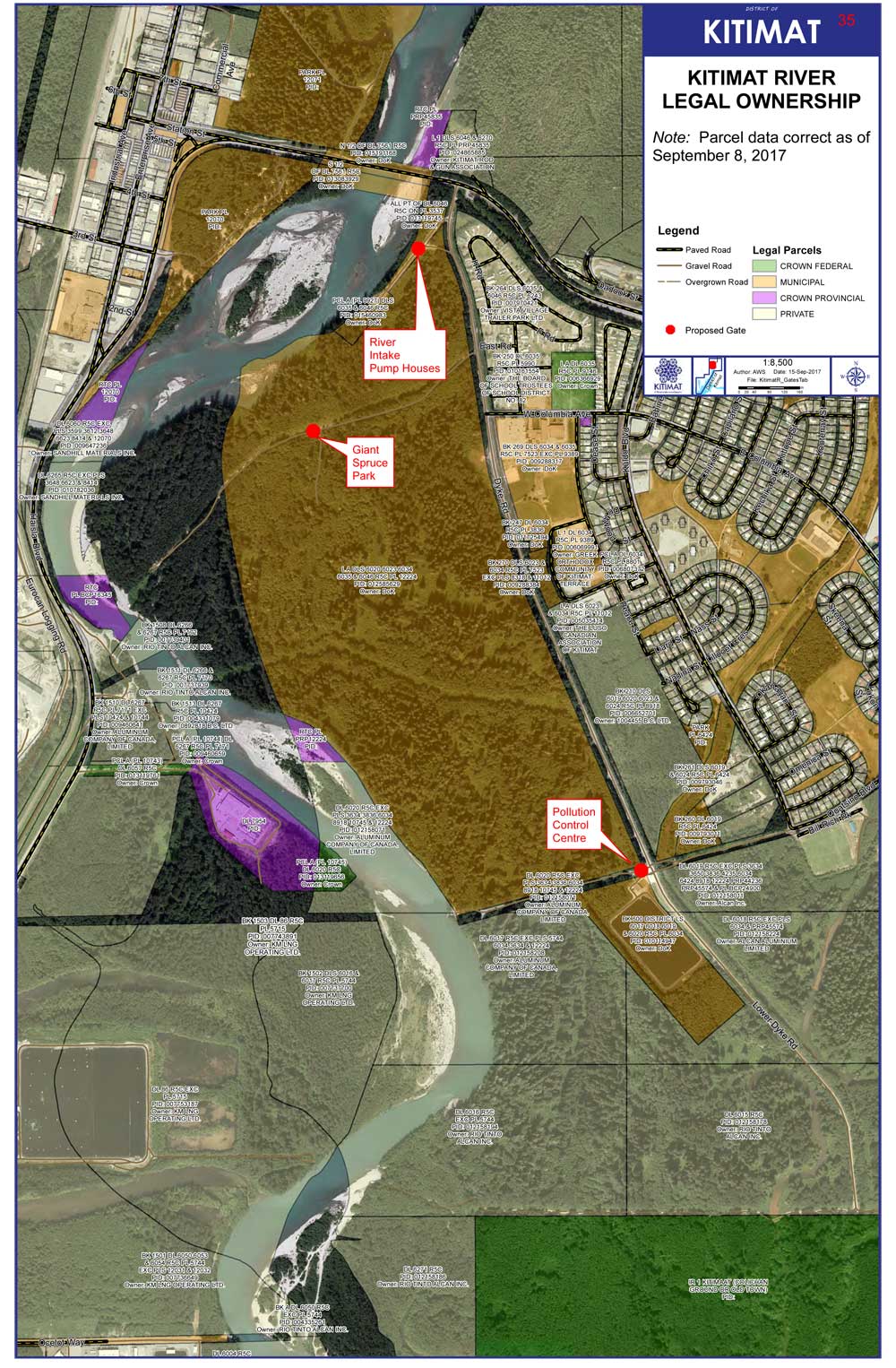
The District of Kitimat has issued a map clarifying just who owns the banks of the Kitimat River, a subject that has been debated for years, as campers have come and gone as they please.
The map issued by the District staff shows that the District of Kitimat has jurisdiction over much of the land on the east side of the river while Rio Tinto owns much of the western bank–but also does own some of the eastern bank in the lower levels.
District staff are recommending that gates be installed in three areas along the eastern bank on municipally owned land, at the Giant Spruce Road, at the Pump House and at the Sewage plant. That could cut off vehicular traffic while still allowing access for pedestrians and those who wish to fish on the river bank by getting access on foot.
The proposed locations of the gates are marked in red on the map.
Map showing who owns the riverbank lands with the proposed gates marked by red dots. (District of Kitimat)
You’ll find a larger version of the map, and staffs’ recommendations to District Council in the report.
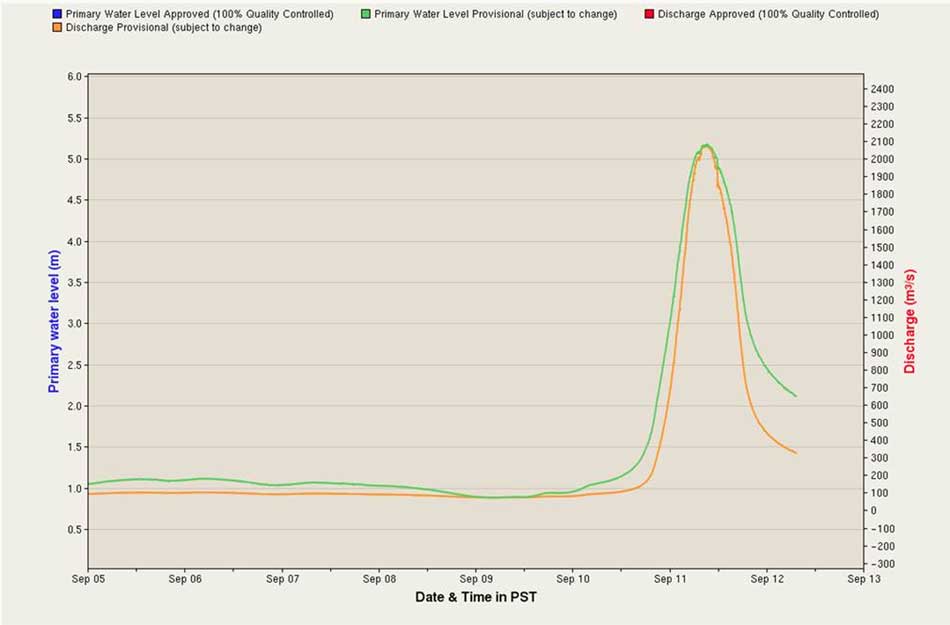
Both the RCMP and Kitimat Fire and Rescue are warning residents to stay away from the Kitimat River until the high water recedes. As well there are likely new hazards from a possible change in the river’s path due to the high water and as well as from debris in Douglas Channel.
Both detachment commander Staff Sergeant James McLaren and Fire Chief Trent Bossance made a special presentation to District of Kitimat Council Monday night to bring council up to date on the events that began early Monday morning.
The riverbanks are still hazardous, McLaren told Council and he urged that everyone stay away for at least the next two days. Anyone going out to fish in the Kitimat Arm of Douglas Channel, may also face hazards from snags, logs and debris such as floating propane cans. Bossance told Council in reply to a question from Councillor Larry Walker.
As well, Bossance told Council that the sudden deluge that began on Sunday afternoon is “not typical at all like the regular October flooding” that may be seen on the river.
Environment Canada chart of the spike in the Kitimat River levels, as presented to District Council. (Environment Canada)
Bossance warned that due to the volume and speed of the water it is likely that some parts of the river bed and river course have changed, and that the sandbars and snag areas that people may be familiar with may have shifted.
The effects of the flood are being monitored by RCMP, Fire and Rescue, Conservation officers, Fisheries and Oceans and provincial environmental officials.
Bossance said that the consensus of those officials is that the flood situation is unique in the history of Kitimat. Environment Canada issued a severe rainfall warning at noon on Sunday.
Bossance told Council that people who were able to leave the riverbank said that they were able to walk out at about one a.m. By 2:30 am, the river had risen so rapidly—about four metres—that by then people were trapped and calling 911 for help. McLaren said the RCMP immediately asked for the assistance of Kitimat Search and Rescue, who then requested assistance from Terrace Swift Water Rescue. Those units rescued twelve people from the riverbank.
A helicopter was called in and rescued two people. The helicopter then made a sweep of the river bank but found no one else in danger.
McLaren told Council that as of 7 pm Monday no one had been reported missing or overdue.
The number of flooded vehicles or vehicles swept into the river is not certain, McLaren said, but the number is estimated between twelve and fourteen ranging from large recreational vehicles to cars. A preliminary assessment by ICBC indicates that the damage or loss of vehicles will be covered but that will have to be confirmed by the vehicle owners.
Bossance said that high tide was not that much of a factor since it occurred at 5:30 am. Most of the high water was runoff from the upper Kitimat River.
Of the fourteen people rescued two were Kitimat residents, the rest from out of town. Emergency social services has assisted those needed to find housing.
The RCMP will continue increased patrols in the river area until the danger has passed.
Malaysia’s energy company remains committed to developing its gas assets in Canada
KUALA LUMPUR, 26 July 2017 – PETRONAS and its partners have decided not to proceed with the Pacific NorthWest LNG project at Port Edward in British Columbia, Canada.
The decision was made after a careful and total review of the project amid changes in market conditions.
PETRONAS’ Executive Vice President & Chief Executive Officer Upstream, Anuar Taib said, “We are disappointed that the extremely challenging environment brought about by the prolonged depressed prices and shifts in the energy industry have led us to this decision.”
“We, along with our North Montney Joint Venture partners, remain committed to developing our significant natural gas assets in Canada and will continue to explore all options as part of our long-term investment strategy moving forward,” added Anuar.
PETRONAS’ commitment in Canada continues through Progress Energy Canada Ltd and its world-class inventory of natural gas resources where the subsidiary plays a key role in supporting PETRONAS’ growth strategy in North America.
PETRONAS and the project’s partners are thankful for the support received from everyone involved, especially the area First Nations, the District of Port Edward, the City of Prince Rupert and their communities for their invaluable involvement and efforts in the project.
UPDATED with comments from District of Kitimat, Terrace and the Gitga’at Nation
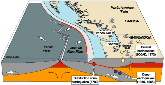
A preliminary seismic hazard assessment by Natural Resources Canada has identified possible earthquake scenarios for the Douglas Channel near Hartley Bay, Terrace and Bella Bella.
The same studies indicate that while Kitimat may not be directly in a seismic zone prolonged earthquakes cause some damage in Kitimat depending on the earthquake and the condition of the soil in certain parts of the District. One model scenario says that in the event of a magnitude 8.0 earthquake off the west coast of Haida Gwaii, given certain soil conditions, there might actually be more damage in Kitimat than on the islands.
Susceptibility to landslides
That assessment, part of the overall the study by the Geological Survey of Canada indicates that the north coast of British Columbia from Prince Rupert to Bella Bella is likely face to “seismically induced ground failure”– mostly landslides.
Overall, the report says that on a scale of 1 to 6 (6 representing the highest
susceptibility), the majority of the west coast of BC “exhibits landslide susceptibility values of 5 to 6, which is significantly higher than the rest of Canada.”
Geological Survey of Canada map showing parts of Canada that are prone to landslides. The BC North Coast study area is outlined by the rectangle. (Geological Survey of Canada)
In British Columbia the landslides are most likely to be triggered by delayed melting of the annual snow pack, heavy rains, bank erosion and site loading and caused long-lasting damning of the river causing “damage to pipelines, rail, and forestry, as well as fish habitats.”
So far no recent landslides along the northern British Columbia coast are known to be caused by earthquakes, the reports say “the existence of numerous landslides strengthens the likelihood of seismically induced ground failures… due to the high levels of seismicity….it is expected that the increased likelihood of strong ground shaking (with long durations) will increase the landslide susceptibility.”
New studies
It was only after the 2012 Haida Gwaii earthquake and with what the Geological Survey of Canada calls “a growing number of on-going and planned infrastructure projects, BC’s north coast is emerging as a region of high strategic importance to Canada’s economy,” that studies began in area where “there has been minimal research to understand earthquake hazards.”
Now that studies have begun the Geological Survey has given the region its own new acronym BCNC (BC North Coast). Haida Gwaii is not part of BCNC, although earthquakes on those islands would likely impact the coast.
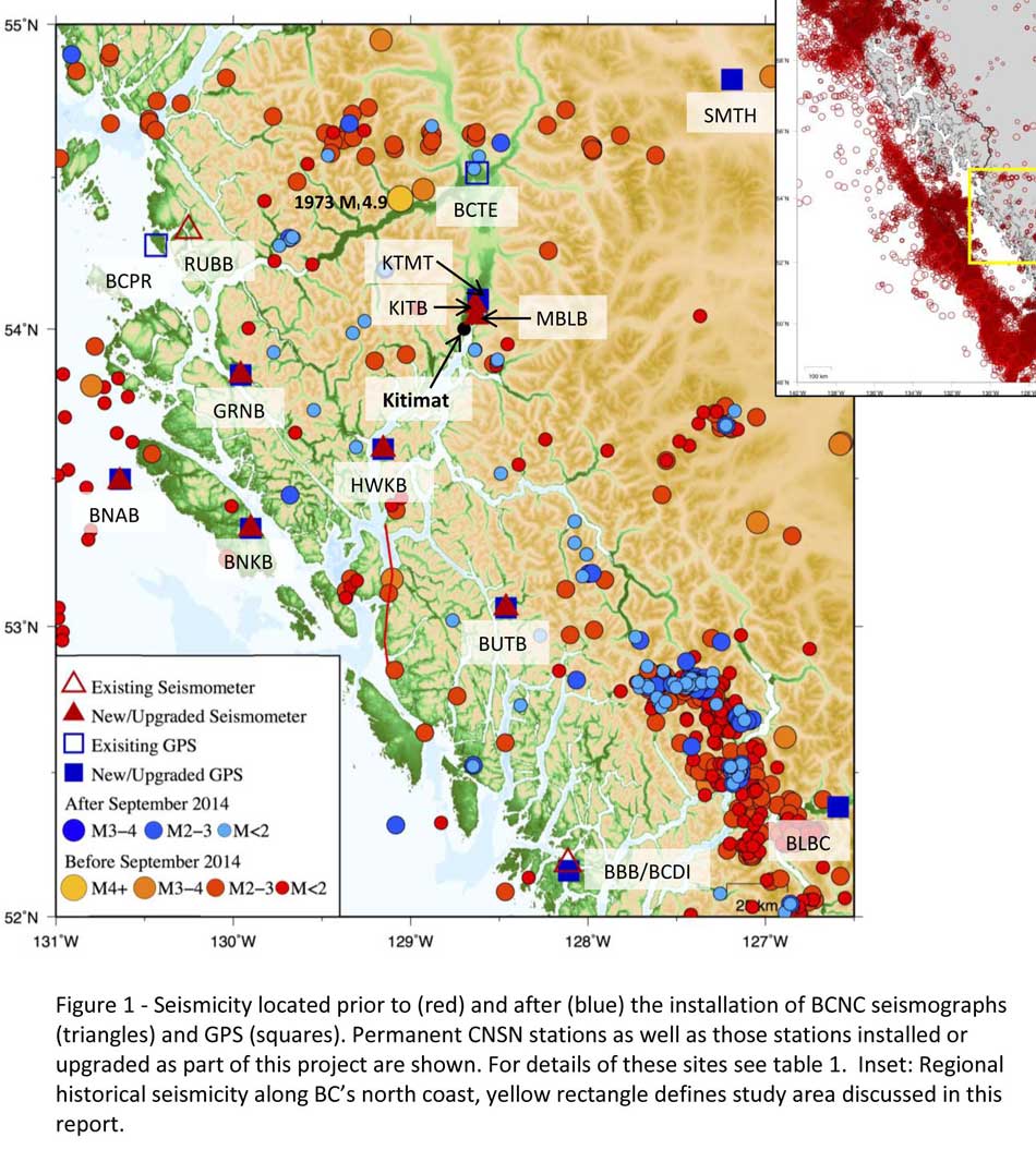
A Geological Survey of Canada map showing the BC North Coast region with earthquakes identified prior to and during recent studies. (Geological Survey of Canada)
The Geological Survey says that historically “the BCNC has been seismically quiescent.” As a result “seismic monitoring and research related to the BCNC has been minimal.” That meant while larger earthquakes were “felt and recorded,” the configuration of the Canadian National Seismograph Network did not allow earthquakes less than approximately magnitude 2.1 to be monitored in northern BC.
Now the Geological Survey is looking at “long-term, continuous monitoring of micro seismicity, combined with geodetic and paleo seismic techniques” that could be used to study at the possibility of large earthquakes, including a possible fault on the lower Douglas Channel.
Since the studies began in August 2014, the Geological Survey identified 145 earthquakes within the study area, many too small to be felt since they are less than magnitude 2.0. Those earthquakes, however, were picked up by the new and improved instrumentation used by the earthquake monitors.
The two reports one on “seismic hazards” and the second on “geohazards” says five “temporary seismonitors” (download reports from links below) were installed within the BCNC while some older stations were upgraded, saying, “It is expected that these new stations will be aid in locating small earthquakes” that were not previously detected by the existing network. The Geological Survey also installed ground movement monitoring GPS units along the coast.
The use of the term “temporary” raises the question about how much ongoing monitoring is planned.
The study also notes that the current data is not included in the seismic standards in the current National Building Code of Canada, which in turn is based on the Natural Resources Canada Seismic Hazard Map. That may mean that municipalities in the BC North Coast region, in the future, as the seismic studies continue, may have to consider updating building codes, especially in areas of “softer soils” as opposed to harder rock.
“Fault-like structure” on Douglas Channel
Detail of a map from the Geological Survey of Canada where the red line shows the 60 kilometre possible (still unconfirmed) fault line running from Gribbell Island to Princess Royal Island (Geological Survey of Canada)
Over the years some small earthquakes have also been recorded on what the Geological Survey calls the “recently mapped fault-like structure” on Douglas Channel which was discovered in 2012. The survey is still calling it “fault-like” because it has not yet been confirmed as an active fault. A new map in the study shows that the “fault” runs from the southern tip of Gribbell Island, down the centre of Whale Channel east of Gil Island and then along the western coast of Princess Royal Island.
The study identified “a small, unfelt swarm of earthquakes between magnitude 1.7 and 2.0 between September 13 and 14, 2010 near Gil Island.”
There is also the previously identified ancient Grenville Channel Fault (ancient and believed inactive because it dates from the Cretaceous, the age of the dinosaurs) that runs from along Grenville Channel from Porcher Island in the north to Klemtu in the south which has experienced small earthquakes.
The report says geological studies of the Douglas Channel “fault-like structure” are a priority because, “Should this structure be determined to be an active fault, it would pose significant risk of earthquake-triggered landslides (and subsequent tsunami) from the susceptible Douglas Channel hill slopes.”
Clay and sand in Kitimat
The report also calls for more studies the local geology and soil conditions in the Kitimat Valley. A study back in 1984 by John Clague of Simon Fraser University showed that as the glaciers retreated during the last Ice Age there were “periods of stagnation” resulting in sediments that are thicker than other regions of British Columbia, Clague reported that in parts of Kitimat, the glacial moraine is hundreds of metres thick.
After the glaciers were gone, the sea levels rose and glaciomarine sediments (clay, silt up to 60 metres thick) were deposited until the sea level fell to present-day levels. The report says that as these marine deposits were exposed to fresh water, salts were leached out resulting in saturated, porous sediments, including clay, which are prone to failure. Boreholes in the Kitimat area show that the clay and sediments above the bedrock can range from 17 metres to 106 metres.
The report notes the presence of clay soils “can amplify ground shaking and secondary effects” as happened in November 1988 when there was an earthquake in the Saguenay region of Quebec.
Originally reported as a 6.2 magnitude but later downgraded to 5.9, on Nov. 25, 1988, the major earthquake was centered near the Quebec cities of Chicoutimi and Jonquière, with aftershocks felt as far away as Toronto, Halifax and Boston. The quake lasted for two minutes, catching thousands of people off guard and leaving buildings damaged and power out for hundreds of thousands of Quebecers.
The report says the most significant event within the BC North Coast study region (which as mentioned doesn’t include Haida Gwaii) was a magnitude 4.9 earthquake approximately 20 kilometers southwest of Terrace on November 5, 1973, which was felt as far as 120 kilometers away, with some minor damage (broken windows and cracked plaster) reported near the epicentre. The main shock at Terrace was preceded by a magnitude 2.5 foreshock four hours before, and followed by a felt magnitude 3.7 aftershock the next day.
Bella Bella at risk
Another area most at risk, according to the report, is southern part of the BC North Coast zone, near Bella Bella, which is close to the northern section Cascadia Subduction Zone a “1,000 kilometre long dipping fault that stretches from Northern Vancouver Island to Cape Mendocino California” which one day will cause a major earthquake along the fault.
Cascadia subduction zone (USGS)
The report says that a magnitude 9.0 or higher earthquake in the northern Cascadia Subduction zone close to Bella Bella would be similar to the March 2011 earthquake in Japan and the 1964 Good Friday earthquake in Alaska.
For the northern part of the BC North Coast region, hazards could come from either a major earthquake off Haida Gwaii or a similar earthquake in south-eastern Alaska.
The greatest hazard would come from “long period” earthquakes greater than magnitude 6.75 with an epicentre between 300 and 350 kilometers away where the shaking lasts longer than one second.
The Geological Survey modeled three possible scenarios for major earthquakes in the BC North Coast Region.
Model #1. A magnitude 8.0 Earthquake at Haida Gwaii
The Geological Survey Canada model for an 8.0 magnitude earthquake west of Haida Gwaii. The possible damage is colour coded in the table below the map according to the Modified Mercalli Intensity Scale. The red polygon represents the area of possible rupture in the model with the star representing the epicentre. (Geological Survey of Canada)
The model looked at a “plausible maximum predicted” magnitude 8.0 thrust fault earthquake off the west coast of Haida Gwaii which would be twice as strong in the fault area as the 7.8 quake on October 28, 2012 (Remember Magnitudes are based on a logarithmic scale. That means for each whole number higher, the amplitude of the ground motion recorded by a seismograph goes up ten times so magnitude 8 earthquake would result in ten times the ground shaking as a magnitude 7 earthquake)
For a short period earthquake, the report estimates that there would be minimal damage on Haida Gwaii similar to the damage from the 2012 earthquake with little or no damage on the BC North Coast.
A long duration, long period earthquake that lasted longer than one second and up to three seconds or longer “may effect taller structures and trigger ground failure (that is liquefaction and lateral shaking).” Kitimat would feel that earthquake with the worst shaking in parts of the District with what the report calls “sensitive soils.” Coastal islands would feel double the amount of shaking as would occur in Kitimat.
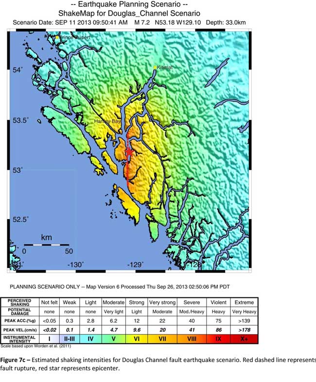
Model #2. A magnitude 7.2 Earthquake in Douglas Channel
The Geological Survey Canada model for a 7/2 magnitude earthquake in the lower Douglas Channel. The possible damage is colour coded in the table below the map according to the Modified Mercalli Intensity Scale. The red star represents the possible epicentre. (Geological Survey of Canada)
The second model looked at an earthquake in Douglas Channel based on the “fault like structure” if a slip strike rupture occurred along the entire 60 kilometers of the so far unconfirmed fault, resulting in a 7.2 magnitude earthquake. There would be very strong shaking within 20 kilometers radius of the epicentre, with moderate to heavy damage” in the relatively uninhabited islands, major shaking in Hartley Bay, resulting in very strong to strong damage at Hartley Bay and strong to moderate damage in Kitimat.
That earthquake, however, would be felt across the entire province of British Columbia. The report notes:
The expected effects and impacts of such an earthquake would mimic those of the 1946 magnitude 7.3 Vancouver Island earthquake, which occurred slightly west of Courtney and Campbell River. Shaking due to the 1946 earthquake was felt as far as Prince Rupert, BC to the north and Portland, Oregon to the south. In addition to knocking down 75 per cent of the chimneys in the local area, much of the earthquake-related damage was due to landslides, slumping and liquefaction
Model #3 A magnitude 6.3 Earthquake near Terrace
The Geological Survey Canada model for an 6.3 magnitude earthquake southwest of Terrace. The possible damage is colour coded in the table below the map according to the Modified Mercalli Intensity Scale. The red polygon represents the area of possible rupture in the model with the star representing the epicentre. (Geological Survey of Canada)
On May 11, 1973, a magnitude 4.7 shallow earthquake took place about 20 kilometers south west of Terrace, on the south side of the Skeena roughly across from the Shames mountain area. The earthquake was felt up to 120 kilometers away. The report says “The event has not been associated with any geologic features in the area and little is known about its rupture process.” The model estimated the results of a larger earthquake 6.3 magnitude in the same area. The model showed there would be strong to very strong shaking in Terrace, light to moderate shaking in Kitimat and light damage elsewhere in the BC North Coast. Most of the damage would be concentrated in a 20 kilometer zone around the epicentre.
The cause of the two failures is still unknown but the report says “their proximity to a nearby unmapped fault-like structure suggests that the slides could have been triggered by strong ground shaking from rupture along this structure.”
Another factor was the two well-known landslides occurred in the 1970’s in the Kitimat Arm which generated tsunamis but fortunately they occurred at low tide which decreased the impact. On October 17, 1974 a submarine slide generated a 2.8 metre tsunami. The following year on April 27, 1975, a slope failure on the northeast side of Kitimat Arm (which overlapped the 1974 failure area) displaced an estimated upper limit of 26,000,000 cubic metres of material.
“Watermark observations in Kitamaat Village estimated that the tsunami generated by this slide was up to 8.2 metres high.” The report says that while the trigger of the first event is unknown; the latter event coincided with nearby construction at that time. Modelling of the 1975 slide estimates that given the right conditions the generated tsunami waves could have been as high as 11 metres.
The report also notes that numerous landslides have also been mapped by the BC Department of Forestry in an attempt to improve safety measures for forestry workers.
The report says “The culmination of these studies brings awareness to the significant natural hazards present in the fragile coastal environment of the Coast Ranges.”
Another factor is the geology of the BC coast. The granitic mountains have rugged, steep slopes dissected by an intricate fjord system and dotted with islands of lower elevation. At lower elevations the land is covered by wet, coastal hemlock forests, which could be vulnerable to ground failures whereas higher elevations are characterized by barren rock or mountain hemlock subalpine.
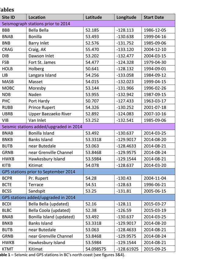
Table of Seismic monitoring and GPS stations in northern BC from the Geological Survey of Canada (Geological Survey of Canada)
The District of Kitimat said it has “not directly studied these issues but we are aware of potential hazards.” The development department has been advised of potential issues and site concerns.
A spokesperson for Terrace mayor Carol Leclerc told Northwest Coast Energy News in an e-mail. “I have reviewed it and distributed it to the relevant department heads. We are aware that historically Terrace has been at risk for experiencing seismic activity due to its location.”
The District of Kitimat did cooperate with National Resources in finding a location for their recently installed seismic equipment.
At Harley Bay, Gitga’at First Nation CEO Ellen Torng said the Gitga’at have been “ working with NRCan on their research in the Douglas Channel and in Hawksbury. NRC has been meeting with First Nations along the coast and have conducted community sessions on their research.
“We hosted one community session here in Hartley Bay and have regular updates from their technical team when they are in the area,” Torng said.
In addition, the District of Kitimat told Northwest Coast Energy News that Community Planning & Development department also provided local land information to geoscientists in the years leading up an international study called Batholiths on land in 2009.
Batholiths are large zones of molten rock that have solidified in the earth’s crust and are believed to play a key role in the formation and growth of continents. The Coast Mountain Range has a large concentration of batholiths, which means Kitimat was an excellent place to study the earth’s crust.
The project, which involved more than 50 scientists from nine Canadian and American universities, was set up to examine how mountain belts form and change over time and why continental mountain ranges are made of granite not basalt. Seismic imaging of the crust and mantle below the mountains required deploying thousands of seismic sensors and recorders, and recorded responses to several man-made detonations. Field work was completed in July 2009, and several scientific papers and dissertations have followed.
The Heiltsuk Nation was unable to respond to a request for comment due to the ongoing crisis from the sinking of the tug Nathan E. Stewart and the resulting spill of diesel fuel and other contaminants near Bella Bella.
Not felt except by a very few under especially favorable conditions.
II
Weak
Felt only by a few persons at rest,especially on upper floors of buildings.
III
Weak
Felt quite noticeably by persons indoors, especially on upper floors of buildings. Many people do not recognize it as an earthquake. Standing motor cars may rock slightly. Vibrations similar to the passing of a truck. Duration estimated.
IV
Light
Felt indoors by many, outdoors by few during the day. At night, some awakened. Dishes, windows, doors disturbed; walls make cracking sound. Sensation like heavy truck striking building. Standing motor cars rocked noticeably.
V
Moderate
Felt by nearly everyone; many awakened. Some dishes, windows broken. Unstable objects overturned. Pendulum clocks may stop.
VI
Strong
Felt by all, many frightened. Some heavy furniture moved; a few instances of fallen plaster. Damage slight.
VII
Very strong
Damage negligible in buildings of good design and construction; slight to moderate in well-built ordinary structures; considerable damage in poorly built or badly designed structures; some chimneys broken.
VIII
Severe
Damage slight in specially designed structures; considerable damage in ordinary substantial buildings with partial collapse. Damage great in poorly built structures. Fall of chimneys, factory stacks, columns, monuments, walls. Heavy furniture overturned.
IX
Violent
Damage considerable in specially designed structures; well-designed frame structures thrown out of plumb. Damage great in substantial buildings, with partial collapse. Buildings shifted off foundations.
X
Extreme
Some well-built wooden structures destroyed; most masonry and frame structures destroyed with foundations. Rails bent.
Northern Gateway pipelines says the company will not appeal the Federal Court of Appeal decision that blocked the approval certificate by the Joint Review Panel and the National Energy Board because there had been insufficient consultation with First Nations.
OTTAWA — The federal government is joining Enbridge Inc. in not appealing a Federal Court of Appeal ruling quashing a 2014 Conservative decision to approve the $7.9 billion Northern Gateway pipeline, Postmedia has learned.
John Carruthers, President of Northern Gateway said in a news release, “We believe that meaningful consultation and collaboration, and not litigation, is the best path forward for everyone involved. We look forward to working with the government and Aboriginal communities in the renewed consultation process.”
Northern Gateway news release
VANCOUVER, Sept. 20, 2016 /CNW/ – Northern Gateway will not appeal a recent Federal Court of Appeal decision that reversed the project’s federal approval certificate. The Federal Court of Appeal found that the National Energy Board’s Joint Review Panel recommendation was acceptable and defensible on the facts and the law. The Court, however, concluded that further Crown consultation is required.
Northern Gateway supports the path outlined by the Federal Court of Appeal for the Federal Government to re-engage with directly affected First Nations and Métis communities to ensure thorough consultation on Northern Gateway is undertaken.
Statement from John Carruthers, President, Northern Gateway:
Northern Gateway’s Ray Philpenko gives a presentation on pipeline leak detection to Kitimat Council, Feb. 17. 2014. (Robin Rowland/Northwest Coast Energy News)
“We believe that meaningful consultation and collaboration, and not litigation, is the best path forward for everyone involved. We look forward to working with the government and Aboriginal communities in the renewed consultation process. We believe the government has a responsibility to meet their Constitutional legal obligations to meaningfully consult with First Nation and Métis. It also reflects the first priority of Northern Gateway and the 31 Aboriginal Equity Partners to build meaningful relationships with First Nation and Métis communities and ensure their voice is reflected in the design of the project.
We believe that projects like ours should be built with First Nation and Métis environmental stewardship, ownership, support, and shared control. Northern Gateway, the Aboriginal Equity Partners, and our commercial project proponents remain fully committed to building this critical Canadian infrastructure project while at the same time protecting the environment and the traditional way of life of First Nation and Métis and communities along the project route.
In order to encourage investment and economic development, Canadians need certainty that the government will fully and properly consult with our nation’s Indigenous communities. We look forward to this process and assisting those communities and the Federal Government with this important undertaking in any way we can.
The economic benefits from Northern Gateway to First Nation and Métis communities are unprecedented in Canadian history. As part of the opportunity to share up to 33 percent ownership and control in a major Canadian energy infrastructure project, the project’s Aboriginal Equity Partners will also receive $2 billion in long-term economic, business, and education opportunities for their communities.
The project would add over $300 billion to Canada’s gross domestic product over the next 30 years, 4,000 construction jobs and 1,000 long-term jobs, $98 billion in tax revenue, and an estimated $100 million investment in community programs and services. Northern Gateway will provide a badly needed multibillion dollar private infrastructure investment in Canada’s future.”
Statement from the Aboriginal Equity Partner Stewards (Bruce Dumont, President, Métis Nation British Columbia; David MacPhee, President, Aseniwuche Winewak Nation; Chief Elmer Derrick, Gitxsan Nation Hereditary Chief; Elmer Ghostkeeper, Buffalo Lake Métis Settlement):
“We support Northern Gateway’s decision to not appeal the recent decision by the Federal Court of Appeal. This is a reflection of the commitment to the new partnership we are building together and their support of meeting Constitutional obligations on government to consult.
The Federal government has publically stated they are committed to reconciliation with First Nation and Métis communities. As such, we are now calling on this same government to actively and fully undertake the required consultation as directed by the Federal Court of Appeal in relation to the Northern Gateway project.
The Aboriginal Equity Partners is a unique and historic partnership that establishes a new model for conducting natural resource development on our lands and traditional territories. We are owners of Northern Gateway and are participating in the project as equals.
Environmental protection remains paramount and as stewards of the land and water, and as partners in this project, First Nation and Métis communities have a direct role in the environmental protection of the lands, waters, and food sources along the pipeline corridor and in marine operations. Our traditional knowledge, science, and values will be used to design and operate land and coastal emergency response to make the project better. We believe with this project there is an opportunity to work together with the Federal Government to improve marine safety for all who live, work, and depend on Canada’s western coastal waters.
This ownership ensures environmental stewardship, shared control, and negotiated business and employment benefits. Collectively, our communities stand to benefit from more than $2 billion directly from this Project.
Our communities need the economic and business benefits that Northern Gateway can bring. We are focused on ensuring our communities benefit from this project and are actively involved in its decision making so we can protect both the environment and our traditional way of life through direct environmental stewardship and monitoring.
Our goal is for Northern Gateway to help our young people to have a future where they can stay in their communities with training and work opportunities. We remain committed to Northern Gateway and the opportunities and responsibilities that come with our ownership. We also remain committed to working with our partners to ensure our environment is protected for future generations.”
The September issue of National Geographic includes a large map of British Columbia it calls “Claiming British Columbia.”
(National Geographic)
The map has three themes: First Nations’ traditional territory, the routes of proposed pipeline projects, both LNG and diluted bitumen, and it features a sub map that looks at what the map calls the “Troubled Salmon” fishery.
The cartographers at National Geographic are being very careful, avoiding such troubling issues as competing land claims among First Nations, unresolved land claims with the federal and provincial governments and treaty status.
(National Geographic)(National Geographic)
So by and large the map groups First Nations by language group unless there are definite treaty or reserve boundaries. Large reserves under the Indian Act are on the map, but given the post stamp size of many reserves in British Columbia, those reserves are too small to be seen on the map. Towns and cities are identified as “First Nations” communities which often overlap with settler communities. Again the map misses many smaller communities, so Kitimat is on the map, while Kitamaat Village is not.
(National Geographic)
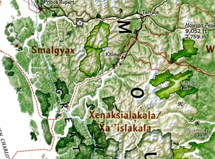
The map identifies Haisla traditional territory as “Xenaksilakala/Xa”islakala” and also includes the Kitlope Heritage Conservancy Protected area.
The article in the September issue is called The Pacific Coast, but unfortunately there is not much of a tie-in with the map, since it concentrates on California and Alaska with only a passing mention of British Columbia.
On the obverse side of the map is the poster that is promoted on the magazine cover, a beautiful painting of “The Changing Pacific Coast” which covers kelp and every creature from phytoplankton and zooplankton all the way to humpback whales and sea gulls (but for some reason no bald eagles). It is likely that poster will be on display in classrooms up and down the coast before school opens next week.
LNG Canada has postponed the Final Investment Decision on the Kitimat project citing the “impact of global industry challenges.” The latest estimates said that the project would cost $40 billion.
The news release says that despite strong community support and regulatory approval, what LNG Canada called “the context of global industry challenges, including capital constraints” led to the decision. In other words, the continued low price of oil is constraining projects across the energy industry.
LNG Canada’s Joint Venture Participants Delay Timing of Final Investment Decision
Impact of global industry challenges, despite strong project fundamentals
Vancouver, British Columbia — Today, LNG Canada announces that its joint venture participants – Shell, PetroChina, Mitsubishi Corporation and Kogas – have decided to delay a final investment decision on LNG Canada that was planned for end 2016.
LNG Canada remains a promising opportunity – it has strong stakeholder and First Nations’ support, has achieved critical regulatory approvals, has important commercial and engineering contracts in place to design and build the project, and through its pipeline partner Coastal Gas Link, has received necessary environmental approvals and First Nations support along the pipeline right-of-way.
“Our project has benefitted from the overwhelming support of the BC Government, First Nations – in particular the Haisla, and the Kitimat community. We could not have advanced the project thus far without it. I can’t say enough about how valuable this support has been and how important it will be as we look at
a range of options to move the project forward towards a positive FID by the Joint Venture participants,” said Andy Calitz, CEO LNG Canada.
Through their efforts to build a strong LNG sector for Canada, and a critical, cleaner energy alternative for the world, the governments of British Columbia and Canada have developed sound fiscal and regulatory frameworks for success.
However, in the context of global industry challenges, including capital constraints, the LNG Canada Joint Venture participants have determined they need more time prior to taking a final investment decision. At this time, we cannot confirm when this decision will be made.
In the coming weeks, LNG Canada will continue key site preparation activities and work with its joint venture participants, partners, stakeholders and First Nations to define a revised path forward to FID.
LNG Canada Joint Venture Participants are Shell (50%), PetroChina (20%), Mitsubishi Corporation (15%)
and Kogas (15%).
Haisla Nation chief councillor Ellis Ross issued a statement that said:
Haisla Nation Council very firmly believes in the future of liquefied natural gas for the Kitimat Valley and Haisla territory. It is an industry which has the capacity to grow jobs, provide new training opportunities and provide a sustained quality of life for Haisla members. It’s worth remembering that LNG Canada is a relatively new project to the area, and decisions on major projects such as these can take a long time to reach.
Today’s decision was the second time the FID was postponed. Andy Caloz LNG Canada’s CEO was quoted by Bloomberg News as saying that the project hasn’t been canceled. It has all the necessary approvals from regulators in Canada and doesn’t require any more work in the country.
“The whole global LNG industry is in turmoil,” Calitz told a conference call, Bloomberg reported, adding that Western Canada still has advantages including its proximity to customers in Asia. “I’m confident that the Japanese market remains available to LNG Canada.”
The National Energy Board has indefinitely suspended its consideration of the $7.9 billion Northern Gateway pipeline project, including the request by Enbridge to extend the deadline for starting the controversial project. The Joint Review Panel conditions had set December 31, 2016 as the time that Enbridge had to start the project.
As a result of the decisions quashing the Certificates, the Board is suspending indefinitely its consideration of the application to extend the sunset clauses of the Certificates and is not accepting any further comments on it, including comments from Northern Gateway and AEP. The Board is also suspending indefinitely its consideration of all filings related to the conditions attached to the Certificates.
In May the NEB had told Enbridge that is would consider a request by Enbridge to extend the deadline and accept comments from the public until June 27, 2016 and reply comments from the applicants by July 18, 2016.
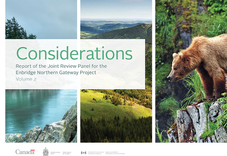
Cover of Volume 2 of the Joint Review ruling on Northern Gateway
In a decision released on 30 June 2016, the Federal Court of Appeal quashed Order in Council P.C. 2014-809 which is the order directing the Board to issue the Certificates for the Project. The Court also quashed the Certificates.
The original Joint Review Panel report in December 2013 had set 209 conditions for the construction and operation of the pipeline, which would have carried oil sands bitumen from Bruderheim, Alberta, to Kitimat, for shipment to Asian customers.
In a two to one decision, the Federal Court of Appeal has overturned the Harper government’s approval of the Enbridge Northern Gateway Pipeline, finding that the federal government’s consultation process with First Nations on the BC coast that occurred after the NEB decision and the Joint Review Panel Report was inadequate, saying:
We conclude that Canada offered only a brief, hurried and inadequate opportunity in Phase IV—a critical part of Canada’s consultation framework—to exchange and discuss information and to dialogue. The inadequacies—more than just a handful and more than mere imperfections—left entire subjects of central interest to the affected First Nations, sometimes subjects affecting their subsistence and well-being, entirely ignored.
The dissenting judge found that the federal government under Stephen Harper had adequately consulted the First Nations. The split decision means that one of the parties, either the federal government, Enbridge Northern Gateway or the Canadian Association of Petroleum Producers may seek leave to appeal to the Supreme Court of Canada.
The Environmental Protection Division of BC’s Ministry of Environment is launching a major study of the water quality in the Kitimat valley, first on the Kitimat River and some of its tributaries and later on the Kitimat Arm of Douglas Channel.
There has been no regular sampling by the province in Kitimat since 1995 (while other organizations such as the District of Kitimat have been sampling).
Jessica Penno, from the regional operations branch in Smithers, held a meeting for stakeholders at Riverlodge on Monday night. Among those attending the meeting were representatives of the District of Kitimat, the Haisla Nation Council, LNG Canada, Kitimat LNG, Rio Tinto BC Operations, Douglas Channel Watch, Kitimat Valley Naturalists and the Steelhead Society.
As the project ramps up during the spring and summer, the ministry will be looking for volunteers to take water samples to assist the study. The volunteers will be trained to take the samples and monitored to insure “sample integrity.” Penno also asked the District, the Haisla and the industries in the valley to collect extra samples for the provincial study and to consider sharing historical data for the study.
With the growing possibility of new industrial development in the Kitimat valley, monitoring water quality is a “high priority” for the province, Penno told the meeting. However, so far, there is no money targeted specifically for the project, she said.
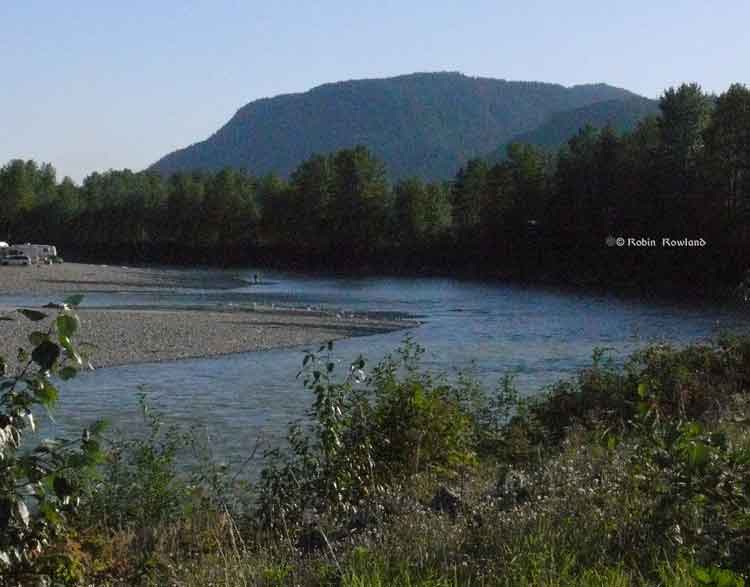
Camping and fishing on the Kitimat River. (Robin Rowland/Northwest Coast Energy News)
The purpose of the study is to make sure water in the Kitimat valley meet the provinces water quality objectives, which have the aim of watching for degradation of water quality, upgrade existing water quality or protect for designated uses such as drinking water, wildlife use, recreational use and industrial water supplies as well as protecting the most sensitive areas. It also provides a baseline for current and future environmental assessment. (In most cases, testing water quality for drinking water is the responsibility of the municipalities, Penno said. The province may warn a municipality if it detects potential problems, for example if a landslide increases metal content in a stream).
Under the BC Environment system, “water quality guidelines” are generic, while “water quality objectives” are site specific.
One of the aims is to compile all the studies done of the Kitimat River estuary by the various environmental impact studies done by industrial proponents.
The ministry would then create a monitoring program that could be effectively shared with all stakeholders.
At one point one member of the audience said he was “somewhat mystified” at the role of Fisheries and Oceans in any monitoring, noting that “when you phone them, nobody answers.”
“You mean, you too?” one of the BC officials quipped as the room laughed.
Water quality objectives
The last time water quality objectives were identified for the Kitimat River and arm were in the late 1980s, Penno told the meeting. The objectives were developed by the British Columbia government because of potential conflict between fisheries and industry at that time. The objectives were developed for the last ten kilometres of the Kitimat River and the immediate area around the estuary and the Kitimat Arm. “The Kitimat is one of the most heavily sport fished rivers in Canada,” she said.
However, the work at that time was only provisional and there was not enough water quality monitoring to create objectives that could be approved by the assistant deputy minister.
There has been no monitoring of the Kitimat River by BC Environment since 1995. “We’ve had a lot of changes in the Kitimat region, with the closure of Methanex and Eurocan, the modernization of Rio Tinto and potential LNG facilities.”
The main designated uses for the Kitimat River at that time were aquatic life, wildlife with secondary use for fishing and recreation.
She said she wants the stakeholders to identify areas that should be monitored at first on the river and the tributaries. Later in the summer, Environment BC will ask for suggestions for the estuaries of the Upper Kitimat Arm.
Participants expressed concern that the water supply to Kitamaat Village and the Kitimat LNG site at Bish Cove as well as Hirsch Creek and other tributaries should be included in the study. Penno replied that the purpose of the meeting was to identify “intimate local knowledge” to help the study proceed.
After a decade so of cuts, the government has “only so much capacity,” Penno said, which is why the study needs the help of both Kitimat residents and industry to both design the study and to do some of the sampling.
The original sampling station in the 1980s was at the Haisla Boulevard Bridge in Kitimat. A new sampling station has been added at the “orange” Kitimat River bridge on Highway 37. There is also regular sampling and monitoring at Hirsch Creek. The aim is to add new sampling points at both upstream and downstream from discharge points on the river.
The people at the meeting emphasized the program should take into consideration the Kitimat River and all its tributaries—if budget permits.
Spring freshette
Last year, the team collected five samples in thirty days in during four weeks in May and the first week in June, “catching the rising river quite perfectly” at previously established locations, at the Haisla Bridge and upstream and downstream from the old Eurocan site as well as the new “orange bridge” on the Kitimat River.
The plan calls for five samples in thirty days during the spring freshette and the fall rain and monthly sampling in between.
The stakeholders in the meeting told the enviroment staff that the Kitimat Valley has two spring freshettes, the first in March during the valley melt and later in May during the high mountain melt.
The plan calls for continued discussions with the industry stakeholders, Kitimat residents and the Haisla Nation.
The staff also wants the industrial stakeholders to provide data to the province, some of it going back to the founding of Kitimat if a way can be found to make sure all the data is compatible. One of the industry representatives pointed out, however, that sometimes data is the hands of contractors and the hiring company may not have full control over that data.
There will be another public meeting in the summer, once plans for sampling in the Kitimat Arm are ready.