The tsunami, Twitter and the Zones: Did social media amplify government generated confusion?

Kitimat, BC and New York City had one thing in common this week, the misuse and use of social media, Twitter and Facebook, that spread both accurate warnings and dangerous misinformation about an impending disaster. In the case of New York and the surrounding area, it was Superstorm Sandy that caused widespread devastation. For Kitimat it was the tsunami warning after the 7.7 earthquake off Haida Gwaii and no damage but a lot of worry for residents.

New York has a population of millions, it is the media centre for the United States, and much of the U.S. Northeast coast is still recovering from the horrendous damage from Superstorm Sandy.
Kitimat has a population of about 8,000 and my home town is off the media radar except when the Enbridge Northern Gateway pipeline issue pops up on the national assignment desks. If the October 27, 2012 tsunami from the Haida Gwaii earthquake did come up Douglas Channel to Kitimat harbour, it was so minimal that any water rise was scarcely noticed.

In one way New York (the state and the city) plus New Jersey and other states were ahead of Kitimat. In the US, there were numerous official sources on Twitter and Facebook, as well as those ubiquitous live TV news conferences with New York Mayor Michael Bloomberg or various state governors.

On October 27, neither Kitimat nor the nearby town of Terrace had any official emergency outlets on social media. In Kitimat, that may change as early as this Monday when District Council considers what happened last Saturday night.

It has been documented that there was no official response from Emergency Management British Columbia (still largely known under its former name Provincial Emergency Program) until an hour after the first earthquake report from the US Geological Survey. Only sometime later did BC’s provincial emergency officials hold a short conference call with reporters. (At the time the BC Liberals were holding a policy convention at Whistler. After the conference call, TV reporters at the convention in Whistler were doing live reports with taped clips of Attorney General Shirley Bond. It should have been easy for Bond and other senior government officials, including Premier Christy Clark–who is plummeting the polls– to hold a live news conference just as US state governors and mayors did later in the week when it came to Superstorm Sandy)

So in that hour of silence from the BC government, one question that has to be raised is: Were the tsunami warnings so completely uncoordinated–at least as far as the public is concerned– that that was one cause of the misinformation and inaccurate information on Twitter and Facebook? Or did confusing information from authorities simply compound and amplify the social media misinformation that was already spreading across British Columbia and around the world?

Here in the northwest, the two area fire chiefs Trent Bossence of Kitimat and John Klie of Terrace have said after the quake that landline phones and some cell phones were out, in some areas up to an hour after the first shock. Klie told CFTK’s Tyler Noble on Open Connection that after the landline phones came back up the Terrace fire department was flooded with calls from people “who wanted it now.” The ability of firefighters to get information was then delayed “because so many people were trying to get through.”

Kitimat has the advantage of being a small town. Emergency services already had scheduled a volunteer recruiting session last Monday night (October 29) for Emergency Social Services–the folks who run, coordinate and work in reception centres during an emergency–so it was easy to turn that meeting into a earthquake/tsunami warning post mortem. (Imagine that happening in New York?)

The most important issue on Saturday night was the false information on both Facebook and Twitter that the Kildala neighbourhood was being evacuated due to the tsunami warning. Other false information on social media indicated that the giant Bechtel work camp at the Rio Tinto Alcan Kitimat Modernization Project was also being evacuated.

As Kitimat’s Emergency Plan Coordinator Bob McLeod told the earthquake post mortem about the information on Facebook and Twitter:
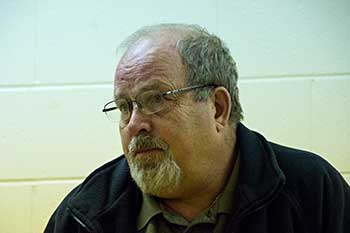
Kitimat Emergency Coordinator Bob McLeod
Kitimat Emergency Coordinator Bob McLeod at the earthquake postmortem Oct. 29, 2012 (Robin Rowland/Northwest Coast Energy News)

“Your aim is to be saving people, and you’re not saving people. There was one case where someone was going around banging on doors in Kildala, telling them to get out. I think it was over when he was in the lockup that night. But this is the type of foolishness that goes on. You have people going on Facebook saying ‘Alcan’s been evacuated. they’re evacuating Kildala.’ I am going to be generous and say it is misinformation… It was a blatant lie. And that does not help.”


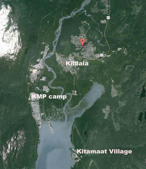
(For those outside Kitimat you can check the town on Google maps) As seen on this screen grab, Kildala is a low lying part of town. The area north of  Highway 37 is higher on a hill. Closer to the ocean at Douglas Channel are the Bechtel/RTA Kitimat Modernization Project work camps.

Map of Kitimat

Walter McFarlane of the Kitimat Daily recounted his experiences at the post mortem. (We were both at a Haisla dinner at Kitamaat Village when the quake struck. See my earlier story here and McFarlane’s Kitimat Daily story here).

After driving from the village to the town, McFarlane told the meeting that he stopped at the town viewpoint where “people were telling me they had already been evacuated out of the Kildala neighbourhood, so my first stop after that was the fire department.” The fire hall is about a couple of blocks from the viewpoint, so it was easy to get accurate information from the fire department.

McFarlane continued, “I found the night of the earthquake that no information is just as bad as wrong information. People were calling me on my cell saying why does the Kitimat Daily say we have to evacuate.” That is because the Daily republished a warning from the Pacific Tsunami Warning Centre that “said tsunami warning, evacuation for the north coast. People were saying we’re on the north coast, we got to go.”

I was about fifteen to twenty minutes behind McFarlane in reaching town. (I did not leave Kitamaat Village until after we heard the first tsunami warning.)  As soon as I got to back in cell  range, my cell phone started to beep with saved messages from my TV and radio news clients calling for information. When I got to my home office, my landline was still dead and would be for about another twenty minutes. The only source of information at that point was Google News, Facebook and Twitter.

I saw the initial, and it turns out general, warning from the Pacific Tsunami Warning Center. Soon I was also getting what I hoped was more specific information  on my marine radio from the Canadian Coast Guard Prince Rupert communications station.

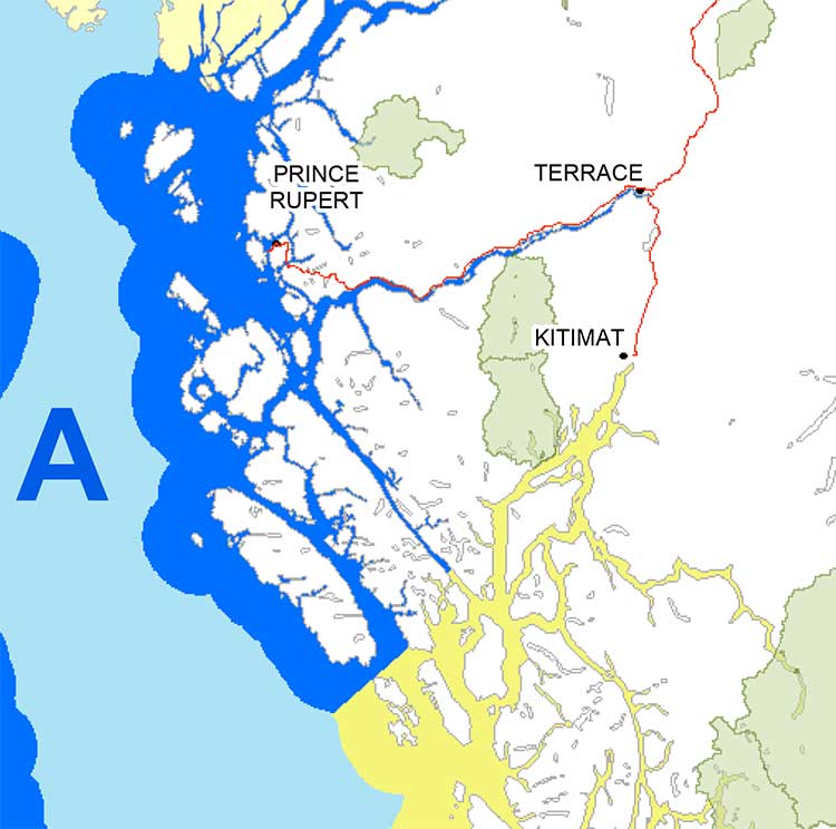
But that, too was somewhat confusing. That Coast Guard advisory mentioned various zones, for example, Zone A and Zone B, but there was little specific context and that point I had no idea what Zone A meant. Prince Rupert Coast Guard Radio then went on to say evacuate low lying coastal areas. (transcript below)

With that confusion, and mindful of “when in doubt, leave it out,” I did not mention the zone system in any information I posted on Facebook and Twitter that night. I only retweeted official information or tweets from reporters I knew and trusted (and I did not see any tweeted official information from the province with a link to the page that identifies the official tsunami zones)

From the interview on CFTK, it appears that both the Kitimat and Terrace fire departments were also getting inadequate information.

“We went to our normal place to look EM BC (Emergency Management BC) and there was nothing there,so we went to Plan B to get information and went on from there,” Bossence told Tyler Noble.

Klie said: “We struggle with that every disaster big or small. Social media, I think emergency organizations are trying to tap into more and more. Up north we may be a little behind the eight ball but sure enough Twitter and Facebook information is out there instantly. Looking at Facebook with my son, I saw that they were evacuating whole cities and I knew that was not true. Because of my experience I can filter some of the information, but there is so much information out there that it’s hard to filter what’s real and not real. It’s an area where emergency coordinators have to get into because its the fastest way of getting information out.”

“Once the phone system came back online at the Fire Hall we got a flood of phone calls,” Bossence told CFTK, “it was nonstop and it was people wanting to know. ‘What’s going on? What are we going to do? Are we leaving?’ and they’re giving us ‘This is what is what I’m reading, this is what I’m being texted, on Facebook they’re saying we’re supposed to evacuate’ adding to that we had an individual going around claiming he was a fire department, he was going door to door and telling people to evacuate. That was the added issue we had to deal with. It was definitely misinformation and a sense of urgency that was coming out through the social network (and eventually the media) was big problem for us.”

In Kitimat, I was told about the man going door to door with inaccurate information and as soon as I confirmed it with reliable official sources, I posted that on both Twitter and Facebook, emphasizing there was, at that time, no evacuation order.

But every situation is different. In contrast, in Superstorm Sandy, another story about men going door to door in Williamsburg, a section of Brooklyn  was not true, as can be seen in an article summing problems with Twitter in New York, where Jared Keller of Bloomberg reported

I experienced this firsthand during Hurricane Sandy. After retweeting a message warning about muggers in Williamsburg dressed as Con Ed workers as an experiment, I received two sceptical responses checking the claim within 15 minutes, both from people who work in the media industry and spend a significant amount of time on Twitter. Within an hour, I received a mass text message from friends of mine who aren’t completely plugged into the social Web with the same warning: “I just read a news alert of two separate reports of people posing as coned workers, knocking on people’s door and robbing them at gunpoint in Williamsburg. I just want to pass along the info. Stay safe and maybe don’t answer your door.” Two other friends responded with thanks.

Keller goes on to stay “I know a lot of people, especially on Facebook, who end up believing whatever they see first,” says Kate Gardiner, a social media journalist. “It’s almost impossible to track something back to its point of origin there.”

You can read Keller’s complete article How Truth and Lies Spread on Twitter  here.

See also How to Tweet Responsibly During a Breaking-News Event by Garance Franke-Ruta  a senior editor at The Atlantic

With the earthquake and tsunami warning Saturday night, Twitter misinformation spread internationally. The first hashtag I saw was #bcquake, but as the the tsunami warning gained traction (especially after the warning was extended from BC and Alaska to Washington, Oregon and California and then to Hawaii) the more common hashtag #tsunami became prominent. As people outside BC began tweeting, they began using #Canadaquake and soon #prayforcanada also began to trend. Completely inaccurate information spread on #prayforcanada (believed to have originated in Indonesia) that it was Vancouver, not the north coast that had been hit by the 7.7 magnitude earthquake.

Are you in the Zone?

At this point, one question has to be asked. The spread of information, first the well-intended but wrong, second just rumour and third, the deliberately misleading, has been seen in social media not only during the earthquake and tsunami on the West Coast last weekend, and during Superstorm Sandy on the East Coast but all the way back to the 2004 Christmas tsunami in Southeast Asia.

For the west coast in 2012, however, how much of the problem of misinformation on social media during the earthquake and tsunami warning was the fault of confusing information from the authorities? Just how were people going to interpret such general terms as “north coast” and “low lying areas.”?

From the BC Provincial Emergency Program you have to ask “What is Zone A?” It turns out by checking a day or so later that the province of British Columbia has created Tsunami Identification Zones.
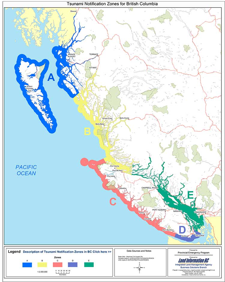
Emergency Management Tsunami Zones
Before October 27, it is likely no one outside of the provincial bureaucracy had ever heard of the provincial tsunami zones. At that time no one in BC, either on Twitter or Facebook or through the media was identifying the BC Tsunami Zones for the public. Later on, the television networks put up maps showing Zones A and B —but that was only good if you had power and were watching the right channel. Kitimat Daily and Terrace Daily posted an official update at 10:42 long after the danger was past explaining the Zone system. It was no good at all if you were listening to news reports on radio or to Prince Rupert Coast Guard Radio on a fishing boat and had no access to the actual maps.

Compounding the confusion is that the US system appears to be very different from the Canadian.

Also the US system has two levels of warning. The Pacific Tsunami Warning Center sends out general warnings but hands over for a more specific warning map from the Alaska -based West Coast and Alaska Pacific Tsunami warning centre. It uses its own system of lettered and numbered zones for the west coast of North America. (See the Oct 27 tsunami advisory here  Note it is a Google maps plugin.)
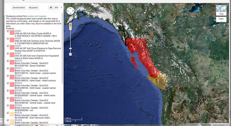
 

Alaska BC tsunami warning map
Possibly adding to uncertainty for those who sail the coast of British Columbia, is that usually when the Canadian Coast Guard talks about zones on marine radio, it is talking about the fishing zones as defined by the Department of Fisheries and Oceans, which are numbered not lettered 
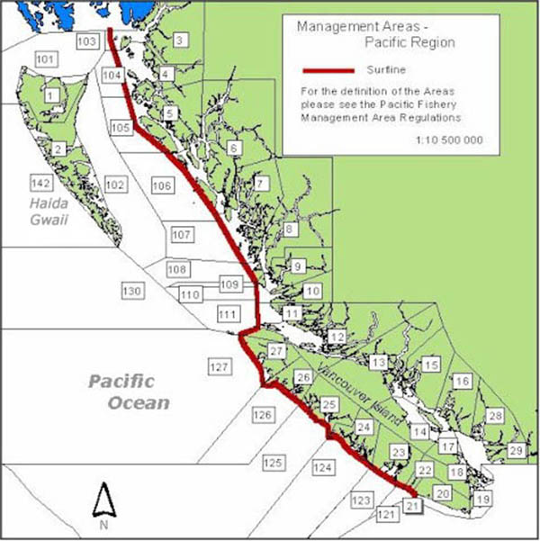
 

DFO Management areas
Fisheries management zones as defined by the Department of Fisheries and Oceams (DFO)


So in case of a tsunami warning, Kitimat is in Zone B for the province of British Columbia and the Provincial Emergency Program and in Zone BZ921 for the West Coast and Alaska Tsunami Warning Centre. For the much more familiar fisheries management areas Kitimat is in Zone 6 (which of course has nothing to do with a tsunami, it’s simply the coastal zone system everyone is familiar with)
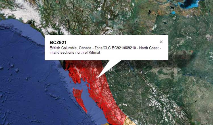
Tsunami warning map
Adding to the confusion is the fact that the EM British Columbia map shows Terrace, far inland up the Skeena River is considered in Zone A, along with Prince Rupert for tsunami warnings (if a tsunami was big enough to reach Terrace along the Skeena River valley, then I can only assume that much of the west coast of North America would have already been wiped out).

Tsunami Zone A


The Monday Post mortem

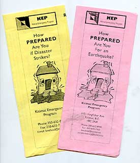
Warning brochuresAt the Monday, October 29 post mortem, when McLeod outlined the events of October 27, he began by looking back three weeks, saying, “I have feeling of frustration about a couple of things. October 7, I took 4,000 brochures [How Prepared Are you if Disaster Strikes?] down to the post office to mail out to the residents of Kitimat, They were all delivered by the post office. On Sunday, I had people coming to me and saying what are we supposed to do in the case of an earthquake? It is really, really difficult to get people interested.”

McLeod said that after he felt the earthquake, he went online to check information and then went up to the fire hall, which is Kitimat’s emergency coordination centre. There he met Fire Chief Bossence, his deputy, the RCMP detachment commander Staff Sergeant Steve Corp and representatives from Bechtel and the Rio Tinto Alcan modernization project.

“For the first little while we were going on line trying to get information. The usual method of dissemination getting information it comes from the West coast and Alaska tsunami warning system, then it goes to Victoria, Victoria gives it to the geophysical specialists and they will confirm or deny what ever the information and then it goes to the Provincial Emergency Program and they shoot it out to coastal communities.

“While in this case you’re working with what you find out from different sources and you are trying to determine how reliable these sources are.”

“In our case, for me the first thing you do when you get word of an impending tidal wave [tsunami] action is check the tide. If you’re on a high tide, it’s a different situation than a low tide

“The movie version of a tidal wave is this 50 foot mountain of water roaring along and this is not what is going to happen particularly in Douglas Channel because of the depth. So you are going to see a surge such as we saw in Japan and it will be an increasing surge of water.

“We were told that potentially some sort of surge hitting Langara  [the northern most island in Haida Gwaii) at 9:16, 9:16 came and went and there was no notification of a noticeable surge of water. So were down to a non event and we were on a receding tide.” (See advisory below)

“Misinformation going out is not helpful,” McLeod said. “You’ve got to set up a stream of how you get information out to people and it’s a valid point. The District Website, the Facebook page, something like that can get information out. But again if you lose power where do get it? Text can work even locally with cell phones. if you’re in a dead area with a cell phone, you can still get text”

McLeod then asked the audience, mainly people ranging from their thirties to seventies if they text. Only four or five people put up their hands. “You people are going to be saved, the rest of us…” McLeod quipped.

If a conclusion can be drawn from the earthquake and tsunami warning in the Kitimat region on October 27, it’s not just that in an emergency inaccurate, incomplete or malicious information can spread a the speed of light on social media, it’s worse that incomplete, inadequate and confusing information from the authorities is amplified and distorted by rapid posting on social media. That concept is not new for anyone who has tried the phone chain game where the outcome is often completely different from the start.

If Gardiner is correct when she says “I know a lot of people, especially on Facebook, who end up believing whatever they see first,” the BC government delays made everything worse. People Tweeted the first thing they saw and the first thing people saw came from multiple and often conflicting sources.  Add that to those Tweets that were exaggeration, rumour and lies.

The problem in 2012 it is not one person talking to one person talking to one person, it is a Tweet or Facebook posting that go out to thousands, or millions of people and that’s a lot more dangerous.

McLeod said the post mortem who said emergency services is trying to get more information out to public, but he added. “The unfortunate part is that if you publish it this week, by Christmas no one will remember. If you start throwing it out every week, it becomes like a stop sign at the end of the street. Nobody sees it.”

(Coming next. If Kitimat had to evacuate)

Transcript of Prince Rupert Coast Guard Radio tsunami warning.

Pan pan. Pan pan. This is Prince Rupert Coast Guard Radio, Prince Rupert Coast Guard Radio. Warning for coastal British Columbia issued by Environment Canada on behalf of the British Columbia Provincial Emergency Program at 2057 Pacific Daylight Time Saturday 27 October. Tsunami warning for Zone A, the north coast and Haida Gwaii,Zone B, the central coast and including Bella Coola, Bella Bella and (unintelligible). A tsunami warning has been issued, if you are in a low-lying area coastal area, you are at risk and must move to higher ground or inland now.
Do not return until directed to do so. Closely monitor local radio stations for additional information from local authorities. Please minimize phone use in affected areas, for further information contact the provincial emergency program at website www. papa echo papa period bravo charlie period charlie alpha.Prince Rupert Coast Guard Radio over.

General warning from the Pacific Tsunami Warning Centre

000
WEPA42 PHEB 280341
TIBPAC

TSUNAMI BULLETIN NUMBER 003
PACIFIC TSUNAMI WARNING CENTER/NOAA/NWS
ISSUED AT 0341Z 28 OCT 2012

THIS BULLETIN APPLIES TO AREAS WITHIN AND BORDERING THE PACIFIC
OCEAN AND ADJACENT SEAS…EXCEPT ALASKA…BRITISH COLUMBIA…
WASHINGTON…OREGON AND CALIFORNIA.

… TSUNAMI INFORMATION BULLETIN …

THIS BULLETIN IS FOR INFORMATION ONLY.

THIS BULLETIN IS ISSUED AS ADVICE TO GOVERNMENT AGENCIES. ONLY
NATIONAL AND LOCAL GOVERNMENT AGENCIES HAVE THE AUTHORITY TO MAKE
DECISIONS REGARDING THE OFFICIAL STATE OF ALERT IN THEIR AREA AND
ANY ACTIONS TO BE TAKEN IN RESPONSE.

AN EARTHQUAKE HAS OCCURRED WITH THESE PRELIMINARY PARAMETERS

ORIGIN TIME – 0304Z 28 OCT 2012
COORDINATES – 52.9 NORTH 131.9 WEST
DEPTH – 10 KM
LOCATION – QUEEN CHARLOTTE ISLANDS REGION
MAGNITUDE – 7.7

EVALUATION

NO DESTRUCTIVE WIDESPREAD TSUNAMI THREAT EXISTS BASED ON
HISTORICAL EARTHQUAKE AND TSUNAMI DATA.

HOWEVER – THE WEST COAST/ALASKA TSUNAMI WARNING CENTER HAS
ISSUED A REGIONAL WARNING FOR COASTS LOCATED NEAR THE EARTHQUAKE.
THIS CENTER WILL CONTINUE TO MONITOR THE SITUATION BUT DOES NOT
EXPECT A WIDER THREAT TO OCCUR.

THIS WILL BE THE ONLY BULLETIN ISSUED FOR THIS EVENT UNLESS
ADDITIONAL INFORMATION BECOMES AVAILABLE.

THE WEST COAST/ALASKA TSUNAMI WARNING CENTER WILL ISSUE PRODUCTS
FOR ALASKA…BRITISH COLUMBIA…WASHINGTON…OREGON…CALIFORNIA.

A more specific warning from the West Coast/Alaska Tsunami Warning Centre


WEAK51 PAAQ 280334
TSUAK1

BULLETIN
PUBLIC TSUNAMI MESSAGE NUMBER 2
NWS WEST COAST/ALASKA TSUNAMI WARNING CENTER PALMER AK
834 PM PDT SAT OCT 27 2012

THE MAGNITUDE IS UPDATED TO 7.7. THE WARNING ZONE REMAINS THE
SAME.

…THE TSUNAMI WARNING CONTINUES IN EFFECT FOR THE COASTAL
AREAS OF BRITISH COLUMBIA AND ALASKA FROM THE NORTH TIP OF
VANCOUVER ISLAND BRITISH COLUMBIA TO CAPE DECISION
ALASKA/LOCATED 85 MILES SE OF SITKA/…

…THIS MESSAGE IS INFORMATION ONLY FOR COASTAL AREAS OF
CALIFORNIA – OREGON – WASHINGTON AND BRITISH COLUMBIA FROM
THE CALIFORNIA-MEXICO BORDER TO THE NORTH TIP OF VANCOUVER
ISLAND BRITISH COLUMBIA…

…THIS MESSAGE IS INFORMATION ONLY FOR COASTAL AREAS OF
ALASKA FROM CAPE DECISION ALASKA/LOCATED 85 MILES SE OF
SITKA/ TO ATTU ALASKA…

A TSUNAMI WARNING MEANS… ALL COASTAL RESIDENTS IN THE WARNING
AREA WHO ARE NEAR THE BEACH OR IN LOW-LYING REGIONS SHOULD MOVE
IMMEDIATELY INLAND TO HIGHER GROUND AND AWAY FROM ALL HARBORS AND
INLETS INCLUDING THOSE SHELTERED DIRECTLY FROM THE SEA. THOSE
FEELING THE EARTH SHAKE… SEEING UNUSUAL WAVE ACTION… OR THE
WATER LEVEL RISING OR RECEDING MAY HAVE ONLY A FEW MINUTES BEFORE
THE TSUNAMI ARRIVAL AND SHOULD MOVE IMMEDIATELY. HOMES AND
SMALL BUILDINGS ARE NOT DESIGNED TO WITHSTAND TSUNAMI IMPACTS.
DO NOT STAY IN THESE STRUCTURES.

ALL RESIDENTS WITHIN THE WARNED AREA SHOULD BE ALERT FOR
INSTRUCTIONS BROADCAST FROM THEIR LOCAL CIVIL AUTHORITIES.
EARTHQUAKES OF THIS SIZE ARE KNOWN TO GENERATE TSUNAMIS.

AT 804 PM PACIFIC DAYLIGHT TIME ON OCTOBER 27 AN EARTHQUAKE WITH
PRELIMINARY MAGNITUDE 7.7 OCCURRED 25 MILES/40 KM SOUTH OF
SANDSPIT BRITISH COLUMBIA.
EARTHQUAKES OF THIS SIZE ARE KNOWN TO GENERATE TSUNAMIS.
IF A TSUNAMI HAS BEEN GENERATED THE WAVES WILL FIRST REACH
LANGARA ISLAND BRITISH COLUMBIA AT 916 PM PDT ON OCTOBER 27.
ESTIMATED TSUNAMI ARRIVAL TIMES AND MAPS ALONG WITH SAFETY RULES
AND OTHER INFORMATION CAN BE FOUND ON THE WEB SITE
WCATWC.ARH.NOAA.GOV.

TSUNAMIS CAN BE DANGEROUS WAVES THAT ARE NOT SURVIVABLE. WAVE
HEIGHTS ARE AMPLIFIED BY IRREGULAR SHORELINE AND ARE DIFFICULT TO
FORECAST. TSUNAMIS OFTEN APPEAR AS A STRONG SURGE AND MAY BE
PRECEDED BY A RECEDING WATER LEVEL. MARINERS IN WATER DEEPER
THAN 600 FEET SHOULD NOT BE AFFECTED BY A TSUNAMI. WAVE HEIGHTS
WILL INCREASE RAPIDLY AS WATER SHALLOWS. TSUNAMIS ARE A SERIES OF
OCEAN WAVES WHICH CAN BE DANGEROUS FOR SEVERAL HOURS AFTER THE
INITIAL WAVE ARRIVAL. DO NOT RETURN TO EVACUATED AREAS UNTIL AN
ALL CLEAR IS GIVEN BY LOCAL CIVIL AUTHORITIES.

PACIFIC COASTAL REGIONS OUTSIDE CALIFORNIA/ OREGON/ WASHINGTON/
BRITISH COLUMBIA AND ALASKA SHOULD REFER TO THE PACIFIC TSUNAMI
WARNING CENTER MESSAGES FOR INFORMATION ON THIS EVENT AT
PTWC.WEATHER.GOV.

THIS MESSAGE WILL BE UPDATED IN 30 MINUTES OR SOONER IF
THE SITUATION WARRANTS. THE TSUNAMI MESSAGE WILL REMAIN
IN EFFECT UNTIL FURTHER NOTICE. FOR FURTHER INFORMATION STAY TUNED
TO NOAA WEATHER RADIO… YOUR LOCAL TV OR RADIO STATIONS… OR SEE
THE WEB SITE WCATWC.ARH.NOAA.GOV.

$$

Did the media over react to the earthquake and tsunami warning?


There were also numerous Tweets on October 27, accusing the media of over reacting. The Haida Gwaii quake was 7.7 magnitude. Compare that to the Haiti earthquake on January 12, 2010 which was 7.0. The Christ Church, New Zealand earthquake on February 27, 2011 which caused major damage was 6.3 magnitude. So the Haida Gwaii earthquake was a major event. The tsunami warning that eventually reached as far off as Hawaii had to be taken seriously.

Fortunately Haida Gwaii is sparsely populated and there was minimal damage largely because most of the houses and buildings are wood and can absorb some of the shaking from an earthquake.

Given the tsunami damage in Southeast Asia in 2004 and in Japan in 2011, no media organization could ignore the developing story.

If there is justifiable criticism, it is that some media over hyped the story in the beginning, rather acting to reassure the public in a responsible manner. But the media that over hyped the earthquake and tsunami are the kind that would over hype any story. That is generally the result of management listening to “TV doctors” and media consultants who urge over hyping to increase ratings. (It often works). But those who,  quite early in the event, who tweeted that the media was overreacting, were themselves guilty of overreaction in their Tweets.
Release of Douglas Channel tsunami report postponed to November 16

The Northern Gateway Joint Review panel has allowed the Department of Fisheries and Oceans and Natural Resources Canada to delay a report on historic tsunamis and a possible fault line on Douglas Channel until November 16, 2012.

The report was scheduled for release on October 31.

In a ruling released by the JRP on November 1, the panel noted:

In Ruling no. 105 dated 24 September 2012, the Panel stated that the Department of Fisheries and Oceans (DFO) could provide “modelling of the potential wave heights and speeds that may  have resulted from two previously unrecognized submarine slope failures in the Douglas  Channel” (Modelling) and that it should do so by 31 October 2012. The letter from Justice Canada seeks an extension to 16 November 2012 as DFO “requires additional time to complete the peer review and approval processes related to this additional written evidence.”
The Panel believes the Modelling to be relevant, as noted in Ruling no. 105. The Panel is also ofthe view that there is unlikely to be any undue prejudice to any party by permitting its filing to be delayed to 16 November 2012.

Accordingly, the Federal Government Participants’ motion is granted and DFO is permitted to file the Modelling on or before 16 November 2012

A preliminary report was released in early September and outlined evidence of major slope failures on the islands in Douglas Channel and also a possible fault line along part of the Douglas Channel.

The Department of Justice filed the request with the JRP on Monday Oct. 30, 2012, less than 48 hours after a major earthquake of magnitude 7.7 struck off Haida Gwaii just after 8 p.m. Pacific Daylight Time, on Saturday Oct. 27, shaking much of northern BC. There have been numerous aftershocks since the main quake.

Panel-Commission Ruling 130 Slope failure report (PDF)

Rio Tinto Alcan reopens access to Kitimat waterfront

Rio Tinto Alcan has reopened Hospital Beach, the nearby boat ramp and Moore Creek and the Moore Creek falls for public use.

RTA took out an ad in a local newspaper Wednesday, Oct. 12, 2012, to make the announcement which came after a meeting members of the District of Kitimat Council on Oct. 4.

The RTA statement reads, in part:

Both Rio Tinto Alcan and the District of Kitimat understand the value and importance of ocean access to residents of the area while at the same time, continuing to respect and ensure that safety is the number one priority.

Over the last few months, while hearing the disappointment and concern about Hospital Beach, the KMP [Kitimat Modernization Project] Construction Team took action to mitigate the public safety risk. The massive rock trucks hauling heavy loads will be re-routed; a new bridge over Anderson Creek has been installed; new traffic lights will be installed near the Construction Village; and an extra construction road has been built from the former Eurocan Haul Road. All these measures have enabled the decision to accommodate the wishes of the community to access Hospital Beach, the boat ramp and Moore Creek safely.

It is important to remind residents however, Rio Tinto Alcan is in the middle of constructing a mega project to modernize and sustain the aluminium smelter business in Kitimat for the benefit of us all. This is the highest priority with many demands and intense focus. To that end, Rio Tinto Alcan will continue to assess traffic patterns and will likely need to make short term closures again as construction dictates. It is imperative that residents respect the company’s right to manage activities on its private property as it deems in the best interest of its business, including the KMP and public safety.

Rio Tinto Alcan and the District of Kitimat have committed together to work toward finding long term solution to ocean access. Thank you all for your patience, support and cooperation.

As the members of District council were meeting in Kitimat, in Prince Rupert, the Northern View reported that CN was cutting off access to part of the town’s waterfront, again for safety issues: CN erects barriers, no trespassing signs along Prince Rupert waterfront

Prince Rupert residents wanting to walk along the road adjoining the ocean past Rotary Waterfront Park will notice new barriers and signs alerting them that they would be trespassing should they do so.
The barricades and signs were put up yesterday, and CN regional manager of public affairs Emily Hamer says it is due to safety concerns with the public on the railway’s property.

Prince Rupert acting mayor Anna Ashley told the Northern View the city expected some restrictions during construction and said the city planned to talk to CN about the issue.

In an e-mail to Northwest Coast Energy News after the October 4 meetingm Kitimat mayor Joanne Monaghan, while hinting  then that a solution to the restrictions was coming, said that industry has been faced with so many lawsuits that safety is becoming a bigger issue.

Councillor Corinne Scott also said that the meeting with RTA stressed that “Large businesses are putting safety as a higher priority.” (She also noted that council agreed to have regular meetings with RTA “.communication lines are open and we look forward to a continued good working relationship between the District of Kitimat and RTA. “)

In both cases, it appears that waterfront access is a legacy issue, left over from an earlier era of industrial development that gave little thought to either the environment or community.
Now it is also apparent that liability lawyers, who probably live thousands of kilometres away from the northwest, have, so far, been driving this issue, with little regard for the needs of local residents.

Make no mistake, safety should be a high priority, but arbitrary restrictions that may look good on legal brief, could actually mean that people would simply try to get around the restrictions, to the determent of safety. It is well known that RTA Plant Protection was finding people at Hospital Beach during the summer, especially at night, despite the publicized restrictions,  barriers and warning signs.

Today with a strong need for jobs in northwestern British Columbia, future community needs for access to waterfront and green space (even in such a wide green area as northern BC) must be taken into consideration in municipal and corporate planning. If that planning isn’t done, that will mean that while there could be jobs, the northwest could be in a situation as it was this summer, with no way to enjoy the advantages of waterfront life in northern BC.


A lesson for BC: Michigan 911 system failed during the Kalamazoo spill, NTSB says

The 911 system failed during the 2010 Marshall, Michigan, Enbridge pipeline breach, according to the full report in the incident released by the US National Transportation Safety Board.

The NTSB report says the 911 operators in Michigan dismissed eight calls reporting gas or petroleum odours over a period of 14 hours between the initial report of a bad odour and the actual discovery of diluted bitumen polluting Talmadge Creek.

The report also says the local firefighters were unfamiliar at that point with potential problems from a bitumen pipeline as opposed to a leak of a consumer natural gas pipeline.

Although the NTSB report puts most of the onus on an inadequate Enbridge “Public Awareness Program” (PAP) which failed to familiarize first responders to potential problems, the report raises questions whether British Columbia, especially the north, is properly prepared for all the energy development that is occurring. Whether or not the Enbridge Northern Gateway project proceeds, there are three active and possibly as many as three or four planned liquified natural gas projects for the northwest, ongoing exploration and production in the northeast and the proposed Kinder Morgan expansion in the lower mainland.

The NTSB says that Sunday, July 25, 2010, at 5:58 pm. EDT, a segment of a 30 inch (7.62 cm) diameter pipeline (Line 6B) operated by Enbridge ruptured in a wetland in Marshall, Michigan. The rupture occurred during the last stages of a pipeline shutdown planned by Enbridge. The leak was not discovered or addressed for over 17 hours, largely due to problems in the Enbridge control room in Edmonton.

During the time lapse, the NTSB says, Enbridge twice pumped additional oil (81 percent of the total release) into Line 6B during two pipeline start ups; the total release was estimated to be 843,444 gallons or 3.192 million litres of crude oil. The oil saturated the surrounding wetlands and flowed into the Talmadge Creek and the Kalamazoo River.

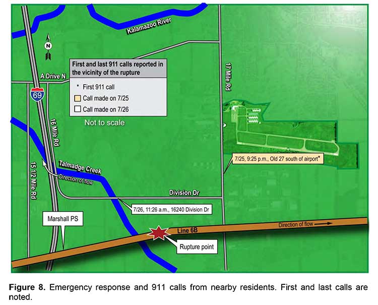
According to the NTSB time line, at 8:56 pm., Michigan Gas Utilities dispatched a senior service technician after residents reported a natural gas odour. At 9:25 pm. on July 25, a local resident called the Calhoun County 911 dispatch:

I was just at the airport in Marshall and drove south on Old 27 [17 Mile Road]
and drove back north again and there’s a very, very, very strong odour, either
natural gas or maybe crude oil or something, and because the wind’s coming out
of the north, you can smell it all the way up to the tanks, right across from where
the airport’s at, and then you can’t smell it anymore.

By 9:32 pm., the Marshall City Fire Department had been dispatched in response to the 9:25 pm. call to 911. The 911 dispatcher told the responders there was a report of a bad smell of natural gas near the airport. The responding firefighters were also dispatched. The firefighters checked pipelines and industrial building near the airport. “using a combustible gas indicator” to try to locate the origin of the odour, but did not detect anything.

NTSB map of first responders at Kalamazoo spill
A map from the NTSB report showing where the fire department responded to the reports of a gas smell at Marshall, MIchigan, and the location of the actual pipeline break. (NTSB)

The NTSB says the service technician from Michigan Gas Utilities “crossed paths with some of the fire department personnel” but found no evidence of a gas leak.

The fire department personnel departed the scene at 10:54 pm. to return to the station.

The NTSB report says: “ a combustible gas indicator measures percentage of the lower explosive limit, it likely would not detect the oil unless it was very close to the source.”

At 11:33 pm, the area’s 911 system received the first of the seven additional calls when an employee at a business called to report a natural gas odour.

The 911 dispatcher told the caller that the fire department had already responded
to calls in the area, and no more personnel were dispatched.

A map of the incident response by the NTSB shows that the area near the airport where the firefighters responded was actually some distance from the pipeline rupture.

Over the next 14 hours, the NTSB says, 911 received seven more calls reporting strong natural gas or petroleum odours in the same vicinity. “The 911 dispatcher repeatedly informed the callers that the fire department had been dispatched to investigate the reported odours.”

Enbridge had been working on restarting the pipeline all night. In Edmonton, at 10:16 am, the Enbridge control room spoke to the regional manager based in Chicago to send someone to
walk along the pipeline, upstream and downstream of the Marshall pumping station.

According to the NTSB, the Chicago regional manager replied, “I wouldn’t think so. If it’s right at Marshall—you know, it seems like there’s something else going wrong either with the computer or with the instrumentation. …you lost column and things go haywire, right?” He went on to say, “…I’m not convinced. We haven’t had any phone calls. I mean it’s perfect weather out here—if it’s a rupture someone’s going to notice that, you know and smell it.” The Chicago regional manager told shift lead C1 that he was okay with the control centre starting Line 6B again.

At 11:17 am, a caller from a second gas utility, Consumers Energy, called the Enbridge emergency line telling the control room: “I work for Consumers Energy[30] and I’m in Marshall. There’s oil getting into the creek and I believe it’s from your pipeline. I mean there’s a lot. We’re getting like 20 gas leak calls and everything.”

At 11:18 am Enbridge closed the remote valves sealing off the rupture site within a 2.95-mile section. By 11:20 am., the shift lead had called the Chicago regional manager to tell him about the notification. By 11:37 am., another Consumers Energy employee notified 911 about the crude oil leak in a creek near Division Drive.

The Fredonia Township Fire Department was dispatched by the 911 centre shortly after the call. At 11:41 am., the Edmonton control centre received confirmation from an Enbridge crossing coordinator located at the Marshall pipeline maintenance shop confirming the oil on the ground.

The NTSB says:

The 911 operators repeatedly informed the callers that the fire department had been dispatched to investigate the issue, but the 911 operators did not contact the pipeline operator or advise the public of health and safety risks. The 911 operators never dispatched the fire department in response to the subsequent calls even though these calls occurred over several hours, indicating an ongoing problem. The actions of both the first responders and the 911 operators are consistent with a phenomenon known as confirmation bias,128 in which decision makers search for evidence consistent with their theories or decisions, while discounting contradictory evidence. Although there was evidence available to the first responders that something other than natural gas was causing noticeable odours in the Marshall area, they discounted that evidence, largely because it contradicted their own findings of no natural gas in the area. Similarly, the 911 operators, with the evidence from the first responders of no natural gas in the area, discounted subsequent calls regarding the strong odours in the Marshall area. Those calls were inconsistent with their own views that the problem causing the odours was either nonexistent or had been resolved.

The NTSB report then says:

Although Enbridge had provided training to emergency responders in the Marshall area in February 2010, the firefighters’ actions showed a lack of awareness of the nearby crude oil pipeline: they did not search along the Line 6B right-of-way, and they did not call Enbridge. The NTSB concludes that had the firefighters discovered the ruptured segment of Line 6B and called Enbridge, the two start ups of the pipeline might not have occurred and the additional volume might not have been pumped.

The NTSB reviewed Enbridge’s PAP, which was intended to inform the affected public,
emergency officials, and public officials about pipelines and facilitate their ability to recognize
and respond to a pipeline rupture.

The report says:

Although RP 1162 requires operators to communicate with audiences every 1 to 3 years, Enbridge mailed its public awareness materials to all audiences annually. However, even with more frequent mailings, this accident showed that emergency officials and the public lacked actionable knowledge.

The NTSB goes on to say:

Public knowledge of pipeline locations and the hazards associated with the materials
transported is critical for successful recognition and reporting of releases, as well as the safe response to pipeline ruptures. The transportation of hazardous materials by pipeline is unlike hazardous materials transportation by railroad or highway because a pipeline is a permanent fixture. A pipeline presents a unique challenge to awareness because it is often buried. When pipeline releases occur, a properly educated public can be the first to recognize and report the emergency.

A survey quoted by the NTSB says that of those who responded in the United States. only 23 percent of the affected public and 47 percent of emergency officials responded that they were “very well informed” about pipelines in their community.

The NTSB says Enbridge failed to properly conduct and monitor its public awareness program and management’s “review of its PAP was ineffective in identifying and correcting deficiencies. The NTSB further concludes that had Enbridge operated an effective PAP, local emergency response agencies would have been better prepared to respond to early indications of the rupture and may have been able to locate the crude oil and notify Enbridge before control centre staff tried to start the line.”

In May 2011, Enbridge revised its public awareness plan and created a public awareness
committee, but just months later, in July 2011, the US Pipeline and Hazardous Materials Safety Administration conducted an audit of Enbridge’s plans and identified several
deficiencies in the company’s program evaluation and effectiveness reviews and required that
Enbridge correct the deficiencies.

Overall, the report says:

Although Enbridge and PHMSA have taken these actions, the NTSB is concerned that
pipeline operators do not provide emergency officials with specific information about their pipeline systems. The brochures that Enbridge mailed did not identify its pipeline’s location. Instead, the brochures directed the audiences to pipeline markers and to PHMSA’s National Pipeline Mapping System. In the NTSB’s 2011 report of the natural gas transmission pipeline rupture and fire in San Bruno, California, the NTSB made the following safety recommendation to PHMSA:

Require operators of natural gas transmission and distribution pipelines and
hazardous liquid pipelines to provide system-specific information about their
pipeline systems to the emergency response agencies of the communities and
jurisdictions in which those pipelines are located. This information should include
pipe diameter, operating pressure, product transported, and potential impact
radius.

The report concludes:

The NTSB recommends that the International Association of Fire Chiefs  and the National Emergency Number Association  inform their members about the circumstances of the Marshall, Michigan, pipeline accident and urge their members to aggressively and diligently gather from pipeline operators system-specific information about the pipeline systems in their communities and jurisdictions.

In Canada, the National Energy Board, which is responsible for overseeing pipeline operations did inspect the Enbridge control room after the NTSB report.

The NEB, of course, has nothing to do with the 911 system.

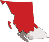
RCMP North District
RCMP map showing the extent of British Columbia’s “North District.” (RCMP)

One question for northern British Columbia is how prepared is the 911 system to handle a major pipeline incident now or in the future. For police and fire, the RCMP communications system must cover all of “North District” from Prince George. (The RCMP did not return a phone call requesting information on 911 training and procedures)

For BC Ambulance the dispatch centre is in Kamloops.

Fire departments in northwest British Columbia, so far, have had minimal training in potential pipeline problems, like the fire department in Michigan, enough to detect and deal with consumer and local industrial natural gas systems. It’s clear that the province of British Columbia, if it is going to promote liquified natural gas as a foundation of a new provincial economy, it must plan and budget for a major upgrade to the 911 system, with a new police, fire and ambulance dispatch centre.


BC’s desire for “world leading” marine standards collides with Harper’s C-38 chain saw massacre

Today BC Premier Christy Clark’s government outlined a series of “world leading” standards for environmental protection on the ocean and on land, if pipeline projects like the Northern Gateway and the Kinder Morgan expansion are to go ahead.

One has to wonder what Premier Clark told Prime Minister Stephen Harper when she gave him the “heads up” call on the new policy last week?

After all, the BC Liberal’s call for “world leading” standards comes just weeks after the Harper’s government, in Bill C-38, changed environmental assessment into a pro-industry process, gutted the Fisheries Act protection for habitat and severely cut back the Department of Fisheries and Oceans and Environment Canada.

So far, in the province of British Columbia, with both the governing Liberals and opposition New Democrats have been spectacularly unsuccessful in persuading the Harper government to reverse the closure of the Kitsilano Coast Guard station.

In the background paper released along with the news release on the five conditions for pipeline and tanker safety, the BC government is calling for greatly enhanced Coast Guard resources and tanker monitoring as well as payment for oil spill response.

Among the conditions for marine safety enhancement BC is asking:

  • Current response times and planning capacity are less stringent than other jurisdictions like Alaska and Norway. For example, for the types of tankers being proposed for Canada’s west coast, Alaska requires planning for 300,000 barrels. In Canada, response organizations are only required to maintain response plans for spills up to approximately 70,000 barrels (10,000 tonnes). Further, Alaska allows responders 72 hours to reach the spill site, while Canada allows 72 hours plus travel time, which can sometimes add days to the response.
  • In shared bodies of water, the United States’ requirements exceed Canada’s. For example, the United States requires escort tugs for laden tankers and mandates industry pay for designated and strategically placed emergency response tugs. Canada does not have any similar requirements.
  • Ensure the Canadian Coast Guard adopts a unified command/incident command structure.
  • The Canadian Coast Guard has a unique response system which is only used in B.C. The United States, companies and governments worldwide use a unified command/incident command response structure for a range of emergency responses, including marine spills. By bringing the Coast Guard under this system, an effective, co-ordinated response is better ensured while reducing layers of approvals that can delay critical, prompt decision-making.

At Enbridge community briefings in Kitimat last year, the company’s own marine experts said that the 72 hour  response time from Vancouver and Victoria for a possible spill in the Douglas Channel was completely inadequate. In its fillings with the Joint Review Panel, Enbridge has proposed setting up and funding its own response stations along the BC coast, although so far, Enbridge has not provided any details on how the response stations would be set up and how they would work.

In 2010, the auditor general reported that Transport Canada and the Canadian Coast Guard have not used a consistent or systematic approach to tanker traffic and spills nor are there formal processes for ensuring that risks are reassessed.

Sheila Fraser found that

  • Procedures are not in place to verify the Canadian Coast Guard’s readiness. In other words, there is currently no process for providing assurance that the federal component of the oil spill response system is ready to respond effectively.
  • The Coast Guard had not conducted a comprehensive assessment of its response capacity since 2000.
  • The results of the Coast Guard’s response efforts—which range from identifying the source of pollution to full cleanup—are poorly documented. There are also limitations with the Coast Guard’s system for tracking oil spills and other marine pollution incidents. These gaps affect its ability to conduct reliable analysis of trends in spills and know how well it is achieving its objectives of minimizing the environmental, economic, and public safety impacts of marine pollution incidents.

In the United States Senate, Canadian Coast Guard response for an oil spill in the Strait of Juan de Fuaca  was described as “call the Americans”

For some search and rescue missions the federal government has indicated that it will rely more on the all-volunteer Royal Canadian Marine Search and Rescue service (formerly the Coast Guard Auxiliary) which is already stretched thin in some areas of the Pacific Coast, rather than the full time professionals from the Coast Guard service itself.

On the industry response, BC says

The federal government should review its rules and requirements to ensure industry-funded response funds are sustainable and adequate to fully cover a major response without requiring public money. Currently, the total amount of ship owner insurance and industry funding available for spill response is $1.3 billion. By comparison, the U.S. federal government maintains a spill fund that is forecast to grow to nearly $4 billion by 2016.

Again given the government backs and the Conservative government’s close ties with the energy industry, one has to wonder what if those provisions can be enforced, especially since more and more of the energy industry in Canada is owned off shore, increasingly in China with its sorry environmental record. (Globe and Mail CNOOC’s Nexen bid: A new test for Harper)

If there are to be “world-leading” standards for environmental protection in this country, it has to be paid for. So the question remains, who will pay for it? The federal government is cutting back, Alberta doesn’t want to raise the relatively small royalties it charges the energy industry and Canada is not likely to get a contribution from China.

Who pays to protect the coast and the northern interior going to be a big question for Stephen Harper in the coming months. With the polls showing Adrian Dix and the NDP leading in contention for a provincial election next year, and now with Christy Clark, apparently, demanding higher standards, will Harper open the Ottawa wallet now, will he wait until he faces a much tougher BC premier in Adrian Dix next year, or will he stubbornly hold his course of forcing Canada into his vision of a conservative, limited government nation, with, in the case of an oil spill on land or sea, that will cost the federal treasury billions, even if the energy industry picks up some of the tab?


Auditor General 2010 Report (pdf)

Auditor General 2007 report  (pdf)


BC’s background information on conditions for pipeline projects

Here is the background information on the BC provincial government’s policy on pipeline projects, as released July 23, by the government:

Related: BC’s desire for “world leading” marine standards collides with Harper’s C38 chain saw massacre

BACKGROUNDER 1

World-leading marine spill preparedness and response systems for British Columbia

Protecting the province’s environment is a priority for its citizens and the B.C. government. While B.C. is not the government lead in terms of responding to a marine spill, advocating for world-class protection measures and procedures is a B.C. priority. Guided by an analysis of international marine response plans and procedures, the B.C. government is moving forward with 11 recommendations to the federal government aimed at improving Ottawa’s marine spill management. Chief among those recommendations are:

Encourage the federal government to strengthen requirements for certified marine spill response organizations.

Current response times and planning capacity are less stringent than other jurisdictions like Alaska and Norway. For example, for the types of tankers being proposed for Canada’s west coast, Alaska requires planning for 300,000 barrels. In Canada, response organizations are only required to maintain response plans for spills up to approximately 70,000 barrels (10,000 tonnes).

Further, Alaska allows responders 72 hours to reach the spill site, while Canada allows 72 hours plus travel time, which can sometimes add days to the response.

Encourage the federal government to enhance tanker requirements and available response capacity.

In shared bodies of water, the United States’ requirements exceed Canada’s. For example, the United States requires escort tugs for laden tankers and mandates industry pay for designated and strategically placed emergency response tugs. Canada does not have any similar requirements.

Ensure the Canadian Coast Guard adopts a unified command/incident command structure.

The Canadian Coast Guard has a unique response system which is only used in B.C. The United States, companies and governments worldwide use a unified command/incident command response structure for a range of emergency responses, including marine spills. By bringing the Coast Guard under this system, an effective, co-ordinated response is better ensured while reducing layers of approvals that can delay critical, prompt decision-making.

Current limits of liability rules strengthened to reduce government and public exposure to financial risk.

The federal government should review its rules and requirements to ensure industry-funded response funds are sustainable and adequate to fully cover a major response without requiring public money. Currently, the total amount of ship owner insurance and industry funding available for spill response is $1.3 billion. By comparison, the U.S. federal government maintains a spill fund that is forecast to grow to nearly $4 billion by 2016.

BACKGROUNDER 2

World-Leading on-land spill preparedness and response system for British Columbia

Land-based spill response is an area where the province has significant management responsibilities. The safe transportation and use of hazardous materials – including oil and natural gas – is critical to British Columbia’s economy and way of life. While land-based spills can be mitigated, they cannot be completely avoided; they are a consequence of a modern economy.

Major resource developments in the province’s northeast, coupled with proposals to open new, and expand existing, transportation corridors for petrochemicals, makes it timely for the province to consider its spill management capacity.

B.C. government’s proposed policy:

A provincial policy review has confirmed support for the “polluter pays” principle. In other words, those sectors (i.e. the oil and gas industry) that pose the risk must be responsible for all related mitigation and response costs.

Ministry of Environment staff are in the process of reviewing options to implement industry-funded and enhanced spill-management for land-based operations. It has three central elements:

An industry-funded terrestrial spill response organization.
An enhanced provincial Environment Emergency Program.
Natural resources damages assessment.
These changes would address some key issues facing B.C.’s land-based spill response practice, including new requirements for:

industry to have tested and government-approved geographic response plans; and
provincial response capacity that matches the known risk, including staff and resources to address spills.
The proposed policy would strengthen the province’s oversight role and facilitate the verification of industry capacity. Further, it would ensure that a stable source of funding is available to ensure the program continues to have a strong presence on-scene when a spill occurs. This role for government is critical to protecting the provincial economic, social and environmental interests that can be impacted when a spill takes place.

Next steps:

Immediately strike a terrestrial spill response working group.
Engagement with key industry associations and federal agencies.
Complete in-depth technical analysis of policy and options.
Public consultation on policy intentions paper.
Draft legislation based on the chosen policy direction.
Media Contact:


BACKGROUNDER 3

Consultation and partnerships with First Nations

In British Columbia, case law requires the B.C. government to consult with First Nations on any decision that may infringe on their treaty or Aboriginal rights. Where government makes a decision that will infringe on rights, there is a legal duty called “accommodation,” which can include mitigation measures, or even economic compensation. These legal requirements impact resource development and government decision-making.

Consultation is not only a legal obligation, it is part of good governance, and the B.C. government takes consultation and the courts’ direction on consultation very seriously.

B.C.’s approach is to work in partnership to give First Nations a meaningful role in land and resource management. B.C. is also the first province to share resource development revenue with First Nations, creating opportunities that flow benefits directly back into Aboriginal communities. B.C. has reached a suite of strategic agreements that create certainty for First Nations and industry by making it easier for business and First Nations to work together.

B.C. has achieved nine Reconciliation and Strategic Engagement Agreements with First Nations. These agreements provide First Nations with a defined role in the management of lands and resources and often include tools to allow for increased First Nation participation in local economies.
B.C. has 189 active forestry revenue-sharing agreements with First Nations. Since 2003, B.C. has provided approximately $323 million and access to 63.9 million cubic metres of timber to First Nations.
B.C. signed mine revenue-sharing agreements with Nak’azdli First Nation and McLeod Lake Indian Band for the Mount Milligan Mine and the Tk’emlúps and Skeetchestn Indian bands for the New Afton Mine. Further agreements are being negotiated.
Economic Benefit Agreements with five Treaty 8 First Nations have provided $52 million to date in First Nation benefits from gas and other development in northeast B.C.
The First Nations Clean Energy Business Fund provides capacity, equity and revenue-sharing funding for First Nation participation in this sector. Since 2010, the fund has provided nearly $2.5 million to 53 First Nations.
The B.C. government has collaborated with the Business Council of British Columbia to develop the best practices to increase general understanding of industry’s role. Increasingly, companies recognize that building relationships with First Nations makes good business sense, and are taking steps to form effective relationships that result in mutual benefits.

B.C. expects proponents to build strong, enduring relationships with First Nations potentially affected by development projects. Through those relationships, there should be discussion of possible impacts on Aboriginal interests, measures in place that would mitigate those impacts and a development of impact management and benefit agreements.


BACKGROUNDER 4

Fiscal benefits imbalance: Northern Gateway Pipeline

The Northern Gateway Pipeline is forecast to provide significant benefits to governments, communities and individuals through taxation and royalty revenues, employment and indirect and induced jobs.

According to a research report by Wright Mansell Research Ltd., the pipeline is likely to generate an incremental $81 billion in provincial and federal government taxation over a 30 year period between 2016 and 2046. Of the $81 billion, a full $36 billion is accrued by the federal government.

The remaining $45 billion in provincial revenues are split with $32 billion to Alberta, $6.7 billion to British Columbia and the remaining $6 billion split among the remaining provinces, with Saskatchewan appearing to benefit by nearly $4 billion. Thus, of the $81 billion in incremental taxation revenue, British Columbia stands to receive approximately only 8.2 per cent.

The $36 billion to the federal government is anticipated to be distributed across the country on a per capita basis as these revenues would be considered to be general and not dedicated revenues. There is no guarantee these revenues would be distributed in this manner.

In addition, with the creation of a new market for Alberta oil in Asia, prices are forecast to rise such that over the same 2016-46 period, there would be a price lift of $107 billion, split $103 billion to Alberta and $4 billion to Saskatchewan, which has begun to exploit its heavy oil and bitumen resources. This lift arises from an all increased value of all oil products that are being exported out of Canada with the elimination of the discount paid for Canadian oil.

Given the risk to British Columbia from land-based and coastal bitumen spills, British Columbia does not believe an equitable distribution exists for fiscal benefits. This imbalance must be addressed prior to British Columbia considering provincial support.


Enbridge files upgraded pipeline and marine safety plans with Northern Gateway Joint Review

Enbridge Northern Gateway today issued a news release saying that it has filed “Reply Evidence” to the Northern Gateway Joint Review panel that contains details of further enhancements in pipeline design and operations. Enbridge says the upgrades will add $500 million to the cost of the $5.5 billion project.

Enbridge has also filed updated plans for marine mammal protection.

The Enbridge news release is a summary of a 43-item filing of the reply evidence with the Joint Review Panel covering a vast number of topics from the pipeline projection to the possibility of earthquakes.

Related: Enbridge files thousands of pages in document dump reply evidence to Northern Gateway JRP

Northern Gateway Pipelines Reply_Evidence  (summary of filings PDF)

Link to 43 item  reply filing  on JRP website

Framework for Marine Mammal Protection Plan  (pdf)

According to the filing, the Marine Mammal Protection plan includes plans by Enbridge to fund research:

Northern Gateway has committed to funding a Marine Research Chair at a university in British Columbia.

Where it is agreed upon by the Marine Research Chair and Northern Gateway, programs and information from the MMPP will be integrated into research undertaken by the Marine Research Chair. Information from the Marine Research Chair may also be of value to the MMPP.


A spokesman for the University of British Columbia told Northwest Coast Energy News that no one from Enbridge has, so far, approached UBC about a Marine Research Chair.  A spokesperson at the University of Victoria also said there had been no contact from Enbridge.

On the pipeline plan, Enbridge says “These extra measures build on the plan in the application presently before federal regulators that already far surpasses industry codes and standards.”

“We recognize that there are concerns among Aboriginal groups and the public around pipeline safety and integrity. We had already planned to build a state-of-the-art project, using the most advanced technology, safety measures and procedures in the industry today,” said Janet Holder, Executive Vice President, Western Access, Enbridge Inc. “With these enhanced measures, we will make what is already a very safe project even safer in order to provide further comfort to people who are concerned about the safety of sensitive habitats in remote areas.”

Enbridge and the Northern Gateway project team have worked hard to ensure this unique project would be built and operated to the highest standards. The measures contained in the Reply Evidence go above and beyond anything that has ever been done before in the industry.

The extra measures include:

Increasing pipeline wall thickness of the oil pipeline
Additional pipeline wall thickness for water crossings such as major tributaries to the Fraser, Skeena and Kitimat Rivers
Increasing the number of remotely-operated isolation valves. This would increase the number of isolation valves in BC by 50%
Increasing frequency of in-line inspection surveys across entire pipeline system by a minimum 50% over and above current standards
Installing dual leak detection systems
Staff pump stations in remote locations on a 24/7 basis for on-site monitoring, heightened security, and rapid response to abnormal conditions
Enbridge expects these extra measures will carry an additional cost of approximately $400 million – $500 million.

“After years of consultation with stakeholders and after personally attending many regulatory hearings for Northern Gateway, it has become clear – we have to do everything we can to ensure confidence in the project,” said Ms. Holder. “We’ve listened. We have often been asked if we could guarantee that we would never have a significant pipeline failure over the years on Northern Gateway. These initiatives will put the project closer than any pipeline system in the world to providing that guarantee.”

Marine Mammal Protection Plan

In the filing, created by Stantec Consulting, Enbridge says the plan will address all marine mammal species that could be directly or indirectly affected  the Northern Gateway project, adding: “Attention will be given to species of cultural importance or heightened sensitivity to potential Project effects.”

The filing says Northern Gateway’s “commitment to a focused marine mammal monitoring and survey program is unprecedented for a marine project in Canada.”

It says that monitoring of marine mammals and “additional cooperative research initiatives” will also be of value to other organizations focused on supporting the recovery strategies for species of conservation concern.”

The report adds a caveat:

It is important to note ….it would be impractical to do a complete assessment of more than 30 different marine mammal species. Going forward, monitoring conducted in the CCAA will include additional marine mammal species For example, during marine mammal surveys, sightings of all marine mammal species would be recorded. In some cases, species-specific research initiatives (e.g., for northern resident (NR) killer whales) may also be implemented. Results from marine mammal monitoring surveys and research initiatives are expected to improve the regional understanding of all marine mammal species’ timing and distribution…


The report says the MMPP will include details on such measures as:

• low-noise propulsion systems on purpose built Project-related vessels (e.g., tug escorts and support
vessels for the marine terminal)
• reduced vessel speeds in the CCAA and in the “CCAA approaches”
• attempting to better understand the behavioural responses of NR killer whales to tankers and tugs
• identifying important habitat for NR killer whales and other cetaceans, as well as seasonal use of these habitats
• use of the results of a science-based quantitative vessel–marine mammal strike risk analysis
• to the extent practicable, allowing for tanker route adjustments (taking into account navigational andhuman safety) to avoid sensitive cetacean habitat during important seasonal periods
• undertaking a cooperative research initiative with other participating organizations to determine
potential effects on marine mammals and to develop industry protocols to limit these effects

From Pro Publica: North Dakota’s Oil Boom Brings Damage Along With Prosperity

Northwest Coast Energy News is republishing this story  on spills and other waste from the North Dakota shale oil and gas boom from the U.S. investigative site Pro Publica. Of most interest to readers here in northwest BC is ProPublica’s map of the spills in North Dakota, which is linked to in the story but not part of the republication package. You can find the map at this link or in the body of the story. That spill map, of course, could be a model for anyone tracking similar events in British Columbia.

North Dakota’s Oil Boom Brings Damage Along With Prosperity
by Nicholas Kusnetz, Special to ProPublica June 7, 2012

Oil drilling has sparked a frenzied prosperity in Jeff Keller’s formerly quiet corner of western North Dakota in recent years, bringing an infusion of jobs and reviving moribund local businesses.

But Keller, a natural resource manager for the Army Corps of Engineers, has seen a more ominous effect of the boom, too: Oil companies are spilling and dumping drilling waste onto the region’s land and into its waterways with increasing regularity.

Hydraulic fracturing 2014 the controversial process behind the spread of natural gas drilling 2014 is enabling oil companies to reach previously inaccessible reserves in North Dakota, triggering a turnaround not only in the state’s fortunes, but also in domestic energy production. North Dakota now ranks second behind only Texas in oil output nationwide.

The downside is waste 2014 lots of it. Companies produce millions of gallons of salty, chemical-infused wastewater, known as brine, as part of drilling and fracking each well. Drillers are supposed to inject this material thousands of feet underground into disposal wells, but some of it isn’t making it that far.

According to data obtained by ProPublica, oil companies in North Dakota reported more than 1,000 accidental releases of oil, drilling wastewater or other fluids in 2011, about as many as in the previous two years combined. Many more illicit releases went unreported, state regulators acknowledge, when companies dumped truckloads of toxic fluid along the road or drained waste pits illegally.

State officials say most of the releases are small. But in several cases, spills turned out to be far larger than initially thought, totaling millions of gallons. Releases of brine, which is often laced with carcinogenic chemicals and heavy metals, have wiped out aquatic life in streams and wetlands and sterilized farmland. The effects on land can last for years, or even decades.

Compounding such problems, state regulators have often been unable 2014 or unwilling 2014 to compel energy companies to clean up their mess, our reporting showed.

Under North Dakota regulations, the agencies that oversee drilling and water safety can sanction companies that dump or spill waste, but they seldom do: They have issued fewer than 50 disciplinary actions for all types of drilling violations, including spills, over the past three years.

Keller has filed several complaints with the state during this time span after observing trucks dumping wastewater and spotting evidence of a spill in a field near his home. He was rebuffed or ignored every time, he said.

“There’s no enforcement,” said Keller, 50, an avid outdoorsman who has spent his career managing Lake Sakakawea, a reservoir created by damming the Missouri River. “None.”

State officials say they rely on companies to clean up spills voluntarily, and that in most cases, they do. Mark Bohrer, who oversees spill reports for the Department of Mineral Resources, the agency that regulates drilling, said the number of spills is acceptable given the pace of drilling and that he sees little risk of long-term damage.

Kris Roberts, who responds to spills for the Health Department, which protects state waters, agreed, but acknowledged that the state does not have the manpower to prevent or respond to illegal dumping.

“It’s happening often enough that we see it as a significant problem,” he said. “What’s the solution? Catching them. What’s the problem? Catching them.”

Ron Ness, president of the North Dakota Petroleum Council, a lobbying group, said the industry is doing what it can to minimize spills and their impacts.

“You’re going to have spills when you have more activity,” he said. “I would think North Dakotans would say the industry is doing a good job.”

In response to rising environmental concerns related to drilling waste, North Dakota’s legislature passed a handful of new regulations this year, including a rule that bars storing wastewater in open pits.

Still, advocates for landowners say they have seen little will, at either the state or federal level, to impose limits that could slow the pace of drilling.

The Obama administration is facilitating drilling projects on federal land in western North Dakota by expediting environmental reviews. North Dakota’s Gov. Jack Dalrymple has urged energy companies to see his administration as a “faithful and long-term partner.”

“North Dakota’s political leadership is still in the mold where a lot of our oil and gas policy reflects a strong desire to have another oil boom,” said Mark Trechock, who headed the Dakota Resource Council, a landowner group that has pushed for stronger oversight, until his retirement this year. “Well, we got it now.”

Reaching ‘the Crazy Point’

Keller’s office in Williston is as good a spot as any to see the impacts of the oil boom.

The tiny prefab shack 2014 cluttered with mounted fish, piles of antlers and a wolf pelt Keller bought in Alaska 2014 is wedged between a levee that holds back Missouri River floodwaters and a new oil well, topped by a blazing gas flare. Just beyond the oil well sits an intersection where Keller estimates he saw an accident a week during one stretch last year due to increased traffic from drilling.

Keller describes the changes to his hometown in a voice just short of a yell, as if he’s competing with nearby engine noise. Local grocery stores can barely keep shelves stocked and the town movie theater is so crowded it seats people in the aisle, he said. The cost of housing has skyrocketed, with some apartments fetching rents similar to those in New York City.

“With the way it is now,” Keller said, “you’re getting to the crazy point.”

Oil companies are drilling upwards of 200 wells each month in northwestern North Dakota, an area roughly twice the size of New Jersey.

North Dakota is pumping more than 575,000 barrels of oil a day now, more than double what the state produced two years ago. Expanded drilling in the state has helped overall U.S. oil production grow for the first time in a quarter century, stoking hopes for greater energy independence.

It has also reinvigorated North Dakota’s once-stagnant economy. Unemployment sits at 3 percent. The activity has reversed a population decline that began in the mid-1980s, when the last oil boom went bust.

The growth has come at a cost, however. At a conference on oil field infrastructure in October, one executive noted that McKenzie County, which sits in the heart of the oil patch and had a population of 6,360 people in 2010, required nearly $200 million in road repairs.

The number of spill reports, which generally come from the oil companies themselves, nearly doubled from 2010 to 2011. Energy companies report their spills to the Department of Mineral Resources, which shares them with the Health Department. The two agencies work together to investigate incidents.

In December, a stack of reports a quarter-inch thick piled up on Kris Roberts’ desk. He received 34 new cases in the first week of that month alone.

“Is it a big issue?” he said. “Yes, it is.”

The Health Department has added three staffers to handle the influx and the Department of Mineral Resources is increasing its workforce by 30 percent, but Roberts acknowledges they can’t investigate every report.

Even with the new hires, the Department of Mineral Resources still has fewer field inspectors than agencies in other drilling states. Oklahoma, for example, which has comparable drilling activity, has 58 inspectors to North Dakota’s 19.

Of the 1,073 releases reported last year, about 60 percent involved oil and one-third spread brine. In about two-thirds of the cases, material was not contained to the accident site and leaked into the ground or waterways.

But the official data gives only a partial picture, Roberts said, missing an unknown number of unreported incidents.

“One, five, 10, 100? If it didn’t get reported, how do you count them?” he said.

He said truckers often dump their wastewater rather than wait in line at injection wells. The Department of Mineral Resources asks companies how much brine their wells produce and how much they dispose of as waste, but its inspectors don’t audit those numbers. Short of catching someone in the act, there’s no way to stop illegal dumping.

The state also has no real estimate for how much fluid spills out accidentally from tanks, pipes, trucks and other equipment. Companies are supposed to report spill volumes, but officials acknowledge the numbers are often inexact or flat-out wrong. In 40 cases last year, the company responsible didn’t know how much had spilled so it simply listed the volume of fluid as zero.

In one case last July, workers for Petro Harvester, a small, Texas-based oil company, noticed a swath of dead vegetation in a field near one of the company’s saltwater disposal lines. The company reported the spill the next day, estimating that 12,600 gallons of brine had leaked.

When state and county officials came to assess the damage, however, they found evidence of a much larger accident. The leak, which had gone undetected for days or weeks, had sterilized about 24 acres of land. Officials later estimated the spill to be at least 2 million gallons of brine, Roberts said, which would make it the largest ever in the state.

Yet state records still put the volume at 12,600 gallons and Roberts sees no reason to change it.

“It’s almost like rubbing salt in a raw wound,” Roberts said, criticizing efforts to tabulate a number as “bean counting.” Changing a report would not change reality, nor would it help anyone, he added. “If we try to go back and revisit the past over and over and over again, what’s it going to do? Nothing good.”

In a written statement, Petro Harvester said tests showed the spill had not contaminated groundwater and that it would continue monitoring the site for signs of damage. State records show the company hired a contractor to cover the land with 40 truckloads of a chemical that leaches salt from the soil.

Nearly a year later, however, even weeds won’t grow in the area, said Darwin Peterson, who farms the land. While Petro Harvester has promised to compensate him for lost crops, Peterson said he hasn’t heard from the company in months and he doesn’t expect the land to be usable for years. “It’s pretty devastating,” he said.

Little Enforcement

The Department of Mineral Resources and the Health Department have the authority to sanction companies that spill or dump fluids, but they rarely do.

The Department of Mineral Resources has issued just 45 enforcement actions over the last three years. Spokeswoman Alison Ritter could not say how many of those were for spills or releases, as opposed to other drilling violations, or how many resulted in fines.

The Health Department has taken just one action against an oil company in the past three years, citing Continental Resources for oil and brine spills that turned two streams into temporary toxic dumps. The department initially fined Continental $328,500, plus about $14,000 for agency costs. Ultimately, however, the state settled and Continental paid just $35,000 in fines.

The agency has not yet penalized Petro Harvester for the July spill, thought it has issued a notice of violation and could impose a fine in the future, Roberts said, one of several spill-related enforcement actions the agency is considering.

Derrick Braaten, a Bismarck lawyer whose firm represents dozens of farmers and landowner groups, said his clients often get little support from regulators when oil companies damage their property.

State officials step in in the largest cases, he said, but let smaller ones slide. Landowners can sue, but most prefer to take whatever drillers offer rather than taking their chances in court.

“The oil company will say, that’s worth $400 an acre, so here’s $400 for ruining that acre,” Braaten said.

Daryl Peterson, a client of Braaten’s who is not related to Darwin Peterson, said a series of drilling waste releases stretching back 15 years have rendered several acres unusable of the 2,000 or so he farms. The state has not compelled the companies that caused the damage to repair it, he said. Peterson hasn’t wanted to spend the hundreds of thousands of dollars it would take to haul out the dirt and replace it, so the land lies fallow.

“I pay taxes on that land,” he said.

At least 15 North Dakota residents, frustrated with state officials’ inaction, have taken drilling-related complaints to the U.S. Environmental Protection Agency in the last two years, records show.

Last September, for example, a rancher near Williston told the EPA that Brigham Oil and Gas had plowed through the side of a waste pit, sending fluid into the pond his cattle drink from and a nearby creek. When the rancher called Brigham to complain, he said, an employee told him this was “the way they do business.”

A spokeswoman for Statoil, which acquired Brigham, said the company stores only fresh water in open pits, not wastewater, and that “we can’t remember ever having responded in such a manner” to a report about a spill.

Federal officials can offer little relief.

Congress has largely delegated oversight of oil field spills to the states. EPA spokesman Richard Mylott said the agency investigates complaints about releases on federal lands, but refers complaints involving private property to state regulators.

The EPA handed the complaint about Brigham to an official with North Dakota’s Health Department, who said he had already spoken to the company.

“They said this was an isolated occurrence, this is not how they handle frac water and it would not happen again,” the official wrote to the EPA. “As far as we are concerned, this complaint is closed.”

Salting the Earth

Six years ago, a four-inch saltwater pipeline ruptured just outside Linda Monson’s property line, leaking about a million gallons of salty wastewater.

As it cascaded down a hill and into Charbonneau Creek, which cuts through Monson’s pasture, the spill deposited metals and carcinogenic hydrocarbons in the soil. The toxic brew wiped out the creek’s fish, turtles and other life, reaching 15 miles downstream.

After suing Zenergy Inc., the oil company that owns the line, Monson reached a settlement that restricts what she can say about the incident.

“When this first happened, it pretty much consumed my life,” Monson said. “Now I don’t even want to think about it.”

The company has paid a $70,000 fine and committed to cleaning the site, but the case shows how difficult the cleanup can be. When brine leaks into the ground, the sodium binds to the soil, displacing other minerals and inhibiting plants’ ability to absorb nutrients and water. Short of replacing the soil, the best option is to try to speed the natural flushing of the system, which can take decades.

Zenergy has tried both. According to a Department of Mineral Resources report, the company has spent more than $3 million hauling away dirt and pumping out contaminated groundwater 2014 nearly 31 million gallons as of December 2010, the most recent data available.

But more than a dozen acres of Monson’s pasture remain fenced off and out of use. The cattle no longer drink from the creek, which was their main water source. Zenergy dug a well to replace it.

Shallow groundwater in the area remains thousands of times saltier than it should be and continues to leak into the stream and through the ground, contaminating new areas.

There’s little understanding of what long-term impacts hundreds of such releases could be having on western North Dakota’s land and water, said Micah Reuber.

Until last year, Reuber was the environmental contaminant specialist in North Dakota for the federal Fish and Wildlife Service, which oversees wetlands and waterways.

Reuber quit after growing increasingly frustrated with the inadequate resources devoted to the position. Responding to oil field spills was supposed to be a small part of his job, but it came to consume all of his time.

“It didn’t seem like we were keeping pace with it at all,” he said. “It got to be demoralizing.”

Reuber said no agency, federal or state, has the money or staff to study the effects of drilling waste releases in North Dakota. The closest thing is a small ongoing federal study across the border in Montana, where scientists are investigating how decades of oil production have affected the underground water supply for the city of Poplar.

Joanna Thamke, a groundwater specialist with the U.S. Geological Survey in Montana, started mapping contamination from drilling 20 years ago. She estimated it had spread through about 12 square miles of the aquifer, which is the only source of drinking water in the area. Over the years, brine had leaked through old well bores, buried waste pits and aging tanks and pipes.

In the Poplar study and others, Thamke has found that plumes of contaminated groundwater can take decades to dissipate and sometimes move to new areas.

“What we found is the plumes, after two decades, have not gone away,” she said. “They’ve spread out.”

Poplar’s water supply is currently safe to drink, but the EPA has said it will become too salty as the contamination spreads. In March, the agency ordered three oil companies to treat the water or to find another source.

North Dakota officials are quick to point out that oversight and regulations are stronger today than they were when drilling began in the area in the 1950s. One significant difference is that waste pits, where oil companies store and dispose of the rock and debris produced during drilling, are now lined with plastic to prevent leaching into the ground.

New rules, effective April 1, require drillers in North Dakota to divert liquid waste to tanks instead of pits. Until now, drillers could store the liquid in pits for up to a year before pumping it out in order to bury the solids on site. The rule would prevent a repeat of the spring of 2011, when record snowmelt and flooding caused dozens of pits to overflow their banks.

But Reuber worries that the industry and regulators are repeating past mistakes. Not long before he left the Fish and Wildlife Service, he found a set of old slides showing waste pits and spills from decades ago.

“They looked almost exactly like photos I had taken,” he said. “There’s a spill into a creek bottom in the Badlands and it was sitting there with no one cleaning it up and containing it. And yeah, I got a photo like that, too.”

Keller has grown so dispirited by the changes brought by the boom that he is considering retiring after 30 years with the Army Corps and moving away from Williston. He runs a side business in scrap metal that would supplement his pension.

Still, determined to protect the area, he keeps alerting regulators whenever he spots evidence that oil companies have dumped or spilled waste.

Last July, when he saw signs of a spill near his home, Keller notified the Health Department and sent pictures showing a trail of dead grass to an acquaintance at the EPA regional office in Denver. The brown swath led from a well site into a creek.

If the spills continued, he warned the EPA in an email, they could “kill off the entire watershed.”

EPA officials said they spoke with Keller, but did not follow up on the incident beyond that. The state never responded, Keller said. The site remained untested and was never cleaned up.

“There was no restoration work whatsoever,” Keller said.


Enbridge to spend $1.6 billion to upgrade Michigan pipeline, old line will be “abandoned in place”

Enbridge announced Thursday, May 10, 2012, it plans to spend $1.6 billion to upgrade and replace its pipeline through Michigan and Indiana, including the site of the leak in to the Kalamazoo River in July 2010. What Enbridge calls the “6B pipeline” broke open near Marshall, Michigan and spilled more than 840,000 gallons of bitumen sands oil into Talmadge Creek and the Kalamazoo River.

That doesn’t mean, however, that the broken and now disused pipeline will be demolished. Enbridge says that pipeline will be “abandoned in place,” meaning it will be deactivated, purged of any remaining oil and then filled with an “inert gas,” a move that is permitted under United States pipeline safety regulations.

In a fact sheet, Enbridge says it plans to replace approximately 75 miles of its 30-inch diameter “Line 6B pipeline.” The 75 miles to be replaced with new pipe consists of about 10 miles in Indiana and 65 in Michigan, with replacement pipe to be either 30 or 36-inch diameter pipe in Indiana and southwestern Michigan and 30-inch pipe in the eastern Michigan segment.

Enbridge map of pipeline 6B
A map, released by Enbridge, showing its plans for upgrading and replacing the 6B pipeline in Michigan and Indiana.

Enbridge says the new pipeline will closely follow the route of the old one.

Completion of this project, scheduled for late 2012, should result in fewer integrity digs and repairs along the replacement segments in the future, resulting in fewer disturbances to landowners and local communities.

For this project, we plan to remove the oil from the pipe segments being replaced and fill them with nitrogen before abandoning in place, as prescribed in regulations. In most cases, the new pipe segments will be installed adjacent to those segments being replaced.

Enbride says the “The Line 6B Maintenance and Rehabilitation Project” is part of the company’s “pipeline integrity maintenance program” that includes:

  • Using high-quality steel and anti-corrosion coatings when constructing our pipelines.
  • Installing cathodic protection (a low-level electrical charge) to inhibit corrosion of underground pipelines. Pressure testing of new and existing pipelines with
    water.
  • Periodically inspecting the inside of the pipeline with sophisticated tools called “smart pigs” to locate
  • pipe abnormalities so they can be corrected.
  • Conducting preventive maintenance programs.
  • Continually monitoring pipeline operations from Enbridge’s control center, which has remote shut-down capabilities and can monitor pressures and conditions when the pipeline is flowing.
  • Completing regular ground and aerial inspections of the right-of-way.
  • Providing public awareness safety information to emergency responders, local public officials, excavators and those who live and work along our pipelines.

Enbridge says the aim of the project is to restore the capacity of the pipeline to meet increasing
demand driven by current and planned refinery upgrades and expansions in Michigan, Ohio
and eastern Canada.

Enbridge plans to complete the Indiana segment of the replacement pipeline by 2012. As for the Michigan pipeline, the company says four segments will be completed in 2012 and the last 160 miles will be completed in late 2012 or early 2013.

All of Enbridge’s plans are subject to U.S. Federal and state approvals.

As for the spill in the Kalamazoo River, the Kalamazoo Gazette, in covering the Enbridge announcement reported today

Although one section of small section of the Kalamazoo River that had been closed following the Enbridge spill in 2010 reopened last month – just three of the 40 miles affected – environmental officials have said significant amounts of oil still remain submerged in the river bed, although they say it is not dangerous to human health. State and federal agencies are slated to open more parts of the river in coming months pending investigation.


Related Links:
WOOD-TV Enbridge plans new $1.6 bil pipeline Oil pipeline will not be demolished

NPR Michigan Radio Enbridge wants to replace 200 miles of aging pipeline in Michigan

Documents 

Enbridge Handout Line 6B Phase 2  (pdf)

Enbridge Handout Line 6B Replacement Project  (pdf)

A map released by Enbridge showing its central Canada and US pipelines


Kitimat council calls on Joint Review Panel, Enbridge to ensure viability of town water supply

District of Kitimat council votes on JRP motion
District of Kitimat Council votes unanimously Apr. 2 to inform the Joint Review Panel about concerns about the town's water supply. (Robin Rowland/Northwest Coast Energy News)

District of Kitimat council voted on Monday, April 2, to ask the Northern Gateway Joint Review Panel to ensure that the town’s water supply is protected if the controversial pipeline is built. A second motion called on Enbridge to give the district a detailed and public presentation on its provisions to protect the water supply in the case of a pipeline breach along the Kitimat River.

That second motion was passed after a motion from Councillor Phil Germuth holding Enbridge responsible for any disruption to the water supply was defeated by a vote of 4-3. However, council’s new motion did not preclude Germuth asking Enbridge his original questions about liability.

Germuth had presented council with the two original motions, after a presentation in March
by Douglas Channel Watch about the dangers avalanches could present to the Enbridge twin pipelines along the Kitimat River watershed.

The first motion called on the District of Kitimat to present a written position to the Joint Review Panel based on the district’s status as a government participant emphasizing the potential dangers to the water supply and noting that the mayor and council are “legally responsible to make every effort to ensure the city of Kitimat’s water supply is uninterrupted and of the highest quality.”

Phil Germuth
Councillor Phil Germuth (Robin Rowland/Northwest Coast Energy News)

After introducing the motion, Germuth said he believed the motion went along with council’s position to remain neutral because nothing in the motion took a position for or against the project.
Councillor Mario Feldhoff said he supported the motion without supporting all the details of Germuth’s full statement, a indication of the more intense debate to come over the second motion.

Mary Murphy also supported the motion, pointing to the potential problems of “transporting hydrocarbons” by both tanker and pipeline.

Mayor Joanne Monaghan said she had a problem with the motion because had earlier passed a motion saying it would wait to take a position until after the Joint Review Panel had reported.

Councillor Corinne Scott said she would speak for the motion, agreeing that this was a request for information and not saying council was for or against the project, adding “we are all concerned about the potential of what could happen to our water supply.”

Read Councillor Phil Germuth’s motions (pdf)

Feldhoff agreed that a letter to the JRP was not taking a position, adding, that on receipt of a letter the Joint Review Panel should take a very serious look at the issue of the water supply of Kitimat. Monaghan agreed but said if the council was to write the letter that it be accurate.

Feldhoff then proposed a friendly amendment calling on District staff to write a draft letter to the Joint Review Panel that council could then examine and agree to.

With the amendment, the motion passed unanimously.

Germuth’s second motion was more contentious, calling on Enbridge to provide detailed plans for ensuring the quality of water for the District of Kitimat and accepting “full liability” for the restoration of the Kitimat’s “entire water system” in case of a pipeline breach. Although some councilors had reservations about Germuth’s list of items, they agreed that Enbridge be called to meet council “face to face,” as Monaghan put it, by responding in person rather than by letter.

Enbridge had already responded to the motion from the previous meeting, calling on it to respond to the concerns raised by Douglas Channel Watch about the possibility of avalanche danger in the Nimbus Mountain area.

In an e-mail to council, Michele Perrett of Enbridge maintained that most of the issue had been addressed by Enbridge in either its original filing with the Joint Review Panel or by subsequent responses to information requests to the JRP, adding

Specifically we have filed geotechnical studies and responded to information requests that include information on avalanches, rock fall, glaciomarine clay slides, debris flows and avulsion in the Kitimat area and have reviewed information filed on this subject by intervenors.

The e-mail said that Drum Cavers, a geotechnical specialist would be making a presentation to council on Monday, April 16.

Enbridge e-mail to District of Kitimat Council (pdf)

Monaghan noted that Douglas Channel Watch and other groups are limited by council policy to 10 minutes and that Murray Minchin had told council that to be fair, Enbridge’s response should also be limited to 10 minutes. Council agreed that the 10 minute limit is needed to make sure that council meetings finish on time and there was some discussion of allowing Enbridge to make a more lengthy presentation outside of a regular council meeting. That would allow Enbridge to not only respond to the earlier concerns about the Nimbus Mountain avalanche danger but also to the concerns about the town’s water supply.

Some members of council, led by Feldhoff, also expressed reservations about the seven points raised by Germuth; others wanted to possibly add their own concerns to any questions for Enbridge. Feldhoff was not prepared to vote for the original motion without more information.

Feldhoff then asked that the district administration prepare a report on the water supply, saying “I think the concerns may be somewhat overstated at the moment.” Councillor Rob Goffinet also called for a report from district staff on the “ramifications for our water supply,” adding that council should not “engage with Enbridge” until that report was ready.

Germuth’s motion, with all of the original questions, along with the invitation for Enbridge to make a public presentation, was then defeated by a vote of 4-3.

Councillor Scott then moved as part of the presentation that Enbridge was earlier invited to present that water issues be added to the list and that council draft a list of questions for the company, that could include Germuth’s original questions.

Germuth asked if the council could put a time limit on Enbridge’s response because the federal budget calls for limiting to the Joint Review Panel. Feldhoff responded that the new motion concerned council’s concerns just with Enbridge and that council should be respectful of Enbridge and hopefully the company could integrate those questions as well.

Goffinet said he wanted Enbridge to know all of the district’s concerns and so, in effect, this motion would get what Councillor Germuth wanted but by a different route, adding that if Cavers, Enbridge’s geotechnical expert, was unable to answer the question, Enbridge would be asked to return and answer the questions at a later date at a public meeting.

That motion passed unanimously.


Update:

Mary Murphy clarified her remarks in an e-mail by saying

I stated I had concerns with all hydro carbons transported along the river coastline…like CN Rail and transporting hydro carbons and the likelihood of a derailment etc, andhow that would also effect our waters. CN Rail is and has been transporting hydro carbons, etc for some time, and have had severe derailments.