The list of participants in the oil spill preparedness and response study released last week by the federal government shows two glaring no shows, the District of Kitimat and Rio Tinto Alcan.
The Haisla Nation and the Gitga’at Nation did provide written submissions to the panel.
The expert panel was set up by the federal government to review “oil handling facilities and ship-source oil spill preparedness and response.” The expert panel was to review the “structure, functionality and the overall efficiency and effectiveness of the system, as well as analyzing the requirements for hazardous and noxious substances, including liquefied natural gas.”
The panel also invited any interested groups to submit documents or their own views to be taken into consideration.
Among the stakeholders interviewed by the panel were companies and organizations very familiar to Kitimat; Chevron and Shell, main partners in two of the LNG projects; Enbridge, which has proposed the Northern Gateway Pipeline and Kinder Morgan which has proposed expanding the dilbit pipeline on the Lower Mainland. Other stakeholders included Coastal First Nations, the Prince Rupert Port Authority, SMIT Marine and the Vancouver Port Authority.
As well as the Haisla and the Gitga’at, five west coast municipalities submitted their own reports to the tanker panel, both the city and districts of North Vancouver, the city of Richmond, the District of Ucluelet and the District of West Vancouver. San Juan County in Washington State also made a submission to the panel. So did the Prince Rupert and Vancouver Port authorities.
Chevron, Enbridge, Imperial Oil, Kinder Morgan, Pacific Northwest LNG, Seaspan Marine, and the Union of BC Municipalities, among others also submitted their views to the panel.
So why didn’t the District of Kitimat participate? When it came to the Enbridge Northern Gateway Joint Review, the mayor and council always maintained their neutrality motion meant that the District would not be an active participant. That was always a short sighted viewpoint. The District should have participated actively in the JRP in such a way as to protect the region’s interests where necessary while remaining neutral. If the District of Kitimat sat out the tanker panel because of the Northern Gateway neutrality policy, that was no excuse, because the expert panel’s mandate specifically included LNG.
Tanker traffic is a potential threat to the San Juan Islands (the Gulf Islands on the American side of the border). It is astounding that San Juan County would think that the Canadian tanker panel was important enough to make a submission and the District of Kitimat did not.
What about Rio Tinto Alcan? Kitimat has been a private port for 60 years, run first by Alcan and then by Rio Tinto Alcan. Why wasn’t RTA asked to participate as a stakeholder? Why didn’t RTA make a submission? Those who are pushing the Northern Gateway terminal always like to say that tankers have been calling at Kitimat for those 60 years. That is true. Of course, none of those tankers have been the Very Large Crude Carriers proposed by Northern Gateway. However, those 60 years means that RTA has the expertise on the Port of Kitimat and Douglas Channel. RTA probably has important data that could have helped both the expert panel and Genivar (which pointed out the paucity of data on small and medium sized tankers). In not participating in the tanker panel submissions and possibly not providing valuable data on Douglas Channel, RTA neglected its social responsibility both to the community of Kitimat and the rest of the province of British Columbia.
The National Energy Board says releasing its decisions in Calgary is standard practice regardless of where in Canada the project is located, and it will not make an exception for its report on the controversial $6.5-billion Northern Gateway pipeline proposal.
Apparently the NEB doesn’t trust reporters in BC to act as professionals. Also, as usual the stock market is more important than the people of BC.
NEB spokesperson Sarah Kiley told the Globe the board ruled out simultaneous lock-ups in Alberta and British Columbia.
“As far as hosting multiple media lock-ups, we need to make absolutely sure that the report is not inadvertently released before the markets close,” Ms. Kiley said. “This becomes more challenging if there are multiple events due to things like the need to ship reports.”
Because the ruling will affect markets, she said the report must be kept confidential until they close on the day of release.
A couple of years ago, on a visit to the Lower Mainland, I was speaking to man who was considering making a 10 minute comment before the Northern Gateway Joint Review panel. In the end, this man, who is by no means a radical environmentalist, just someone worried about the future, decided not to testify, telling me: “The National Energy Board is nothing more than an extension of the Petroleum Club.”
Once again today, the National Energy Board showed its contempt for British Columbia and proved my source’s belief that it is nothing more than an extension of the Petroleum Club.
Vancouver radio station News 1130 made a routine inquiry to the NEB about a reporters’ “lockup” on the day that the JRP decision is released. A “lockup” allows the media to read an embargoed report a few hours in advance so that at the moment it is officially released, it can print or broadcast an accurate account of a government report.
News 1130 was told by the NEB that there would be no lockup in British Columbia, only reporters in Calgary, the home of the NEB, will have that opportunity, because “logistics did not work out for a lock-up” in Vancouver.
(Reporters who work along the actual pipeline route in the north are even farther off the NEB radar. The Calgary lockup will leave northerners to figure out what the JRP decision actually means from reports from Alberta-based journalists. The history of the past few years has proven that most Alberta-based reporters have little interest or knowledge of the concerns of northwest British Columbia.)
Before the JRP hearings began in January, 2012, a well-known northern First Nations leader predicted all this in a background conversation. He noted that there was no representation from British Columbia on the Joint Review Panel. The JRP had two members from Alberta, chair Sheila Leggett, and member Kenneth Bateman, while the “First Nations member,” Hans Matthews, was from Ontario. The First Nations leader, who would have to appear before the JRP, privately called them “flatlanders” with no knowledge of B.C.
He was right.
Even before that conversation, the Joint Review Panel blundered in its first appearance in Kitimat, the preliminary hearing at Riverlodge on August 30, 2010, by offending the Haisla Nation with a schedule of appearances crafted in Calgary that ignored that Kitimat is on Haisla traditional territory and put then Chief Counsellor Dolores Pollard well down on the schedule. That hearing was held up for about half an hour while the JRP scrambled to undo their mistake.
While the JRP did finally learn to respect the customs of BC’s First Nations, and the panel was often hamstrung by arcane and obsolete rules of procedure, the panel too often proved far too inflexible in understanding the issues along the pipeline route and up and down the coast.
The most recent example was the JRP’s refusal to consider the recent evidence from both scientists and Fisheries and Oceans about the growing importance of humpback whales in Douglas Channel. The JRP’s excuse was that the window for evidence had closed. If the Northern Gateway actually goes ahead, Enbridge speaks about the 30-year-life of the project. Yet the JRP’s continuing inflexibility acts as if all the key issues can be decided by the December 30 deadline and after that everything will be just fine.
In the past few weeks, report after report has been released on projects that will change the lives of the people of the northwestern British Columbia. The media of the northwest, all with very limited budgets, have been ignored time and time again.
On Tuesday, the federal government also used Vancouver to release a report on tanker traffic. While Vancouver is also vulnerable to tanker problems, the feds considered their message could be carried best by the mainstream major metro media. Again, no one bothered with the northwest, where the tankers will be sailing along the coast and up and down Douglas Channel.
A few weeks ago, BC Premier Christy Clark announced her agreement with Alberta Premier Alison Redford on the compensation issue, one of her five conditions for heavy oil development in the province. Clark solved the political dispute with Alberta by handing off the compensation issue from the province to the energy industry with absolutely no guarantee that the energy companies will actually offer compensation for crossing BC. Northern reporters could listen in to an audio feed of the news conference from the BC government website, but could not ask questions.
In the 21st century, of course, these news conferences are not about presenting factual information; the news conferences are about getting out a government message track, so questions from reporters who actually know about issues are not wanted.
The Joint Review Panel (with the NEB one of the “joint” partners) is supposedly, on paper, a quasi-judicial body, independent of the government.
If the JRP wants to salvage even a bit of its crumbling credibility for its Northern Gateway decision, it will show that it respects British Columbia. The means holding two additional lockups. If Terrace was good enough for the final arguments, and a central location for the northwest, one lockup should be held in Terrace, so northerners can read reporting by northwest-based reporters. The second, of course, should be in Vancouver for the province’s major media centre.
Given the record of the past two years, don’t hold your breath, time and time again the bureaucratic priorities and the fact that the NEB is thoroughly embedded in the energy culture of Alberta, it is likely that the release of the report sometime in the coming weeks will be Alberta-centric and will prove my source right, that the NEB is nothing more than that extension of the Petroleum Club.
The board plans to hold a media lock-up in Calgary, but does not have similar plans to brief reporters in British Columbia, says an official with the independent federal agency established to regulate international and interprovincial issues around the electrical utility, gas and oil sectors.
Board spokesperson Sarah Kiley said Thursday that the board recognizes there is an interest in B.C. in the subject, and said there is no final plan yet.
The Globe was unable to get a statement from the Liberal government of BC but for the opposition,Spencer Chandra Herbert (Vancouver-West End) said, the energy board should not be hiding out in Calgary when they announce what they are going to do, regardless of whether they approve or reject the project.
“You would think they would have the ability and respect for B.C. to host it here and explain whatever decision they make here to B.C. media and intervenors,” he said.
BC Parks and the Gitga’at First Nation are calling for public input as they development a management plan for the K’nabiyaaxl/Ashdown Island Conservancy at the mouth of Douglas Channel.
BC Parks describes the area as:
K’nabiyaaxl/Ashdown Conservancy covers 727 hectares of marine and uplands ecosystem on the northwest coast of British Columbia, south of Gil Island. The conservancy is 40 kilometres south of Hartley Bay and 120 kilometres southwest of Kitimat. The conservancy is in the traditional territory of the Gitga’at First Nation.
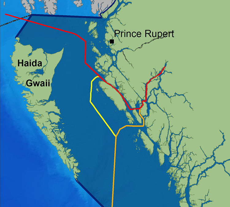
Although not well known outside the Kitimat region, Ashdown Island did receive some measure of fame because it was one of the islands that disappeared from Enbridge’s promotional animation of the tanker route for diluted bitumen from Kitimat to Asia if the controversial Northern Gateway project goes ahead. As well as a haven for wildlife, Ashdown is known as a prime halibut fishing area.
Ashdown Island study area (BC Parks)
Ashdown Island is on the proposed “Southern Approach” for Enbridge’s tanker traffic routes.
The area and nearby waters have been and continue to be intensively used by the Gitga’at people for cultural, social and economic purposes. In Tsimshian language (Sm’algyax), K’nabiyaaxl means “place where cliff” – which is located on the west side of Ashdown Island.
The conservancy encompasses all of Ashdown Island and the foreshore area
and land covered by water within 200 metres of the high tide line. It
has high intertidal values, especially for seaweed, and contains an important
Steller Sea Lion haulout. The waters around the island support important Gitga’at
community fisheries.
Although in Gitga’at traditional territory, the plan notes that the Haisla, the Kitasoo community of Klemtu; and Gitxaala community of Kitkatla on Dolphin Island should be consulted.
It goes on to say:
The conservancy protects an entire small island representative of the Hecate Lowlands Ecosection. The island’s foreshore marine environments include high value intertidal areas which provide high value habitat for important marine wildlife species and migratory birds. The conservancy also protects a haulout for Stellar Sea Lions (Eumetopias jubatus), a species of concern (provincially blue- listed3)…
Stellar Sea Lions use small islets off the south end of Ashdown Island as a winter
haulout, with up to 12 pups and 107 adults observed
The plans lists the Humpback Whale (Blue-listed, S1N); the. Killer Whale (Red- or Blue-listed, S2 or S3 depending on sub-species); and the Fin Whale; as Ashdown Island species at risk. (SARA species schedule procedure site)
As well:
The conservancy contains seven hectares of potential Marbled Murrelet habitat
which, although small, may provide important habitat when combined with core
Marbled Murrelet habitat in nearby areas.
K’nabiyaaxl’s remote location provides an excellent opportunity for maintaining
biological diversity and natural environment values. This habitat should not be
disturbed by conservancy use and development.
The island and the near shore are also part of the Gitga’at’s rich cultural heritage.
The conservancy is near the seasonal Gitga’at village camp of K’yel. The Gitga’at
travel in the spring from Hartley Bay to K’yel, which they use as a base for conducting intensive marine and intertidal harvesting and hunting activity.
Since time immemorial, the Gitga’at people have harvested fish and marine
mammal species in waters adjacent to K’nabiyaaxl. They also collect seaweed,
plants and berries from intertidal and upland areas on the island.
Archaeological sites are known to exist in the area. That the BC Archaeological
Branch does not have archaeological sites registered in the conservancy is not
indicative of the rich history of Gitga’at occupancy and use of K’nabiyaaxl.
A second floating liquified natural gas terminal may be planned for Kitimat, Northwest Coast Energy News has learned.
According to multiple sources in Kitimat, Altagas, the parent company of Pacific Northern Gas plans the terminal at the old log sort site on Douglas Channel, where the barge carrying the liquifaction equipment would likely be moored next door to the already planned BC LNG/Douglas Channel Partners LNG project which would be served by gas delivered by the PNG pipeline system.
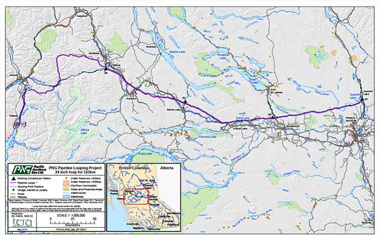
Pacific Northern Gas has filed an application with the BC Environmental Assessment Office to construct and operate an approximately 525 kilometre, 610 millimetre (24 inch) diameter natural gas pipeline from the natural gas hub at Summit Lake, near Prince George, to Kitimat that would loop or twin the existing PNG existing natural gas pipeline.
The application to the BCEAO says: “The proposed Project would supply natural gas to proposed liquefied natural gas (LNG) export facilities as well as the Proponent’s existing customers. The proposed Project would include the replacement of four existing compressor stations and would have an initial capacity of 600 million standard cubic feet per day.”
PNG Pipeline Looping Project Open House at Tamitik. Nov. 26, 2013. (Robin Rowland/Northwest Coast Energy News)
On Tuesday, November 26, Pacific Northern Gas held a sparsely attended open house at Tamitik Arena as part of the BCEAO public comment procedure.
A 38 day public comment period on the application information requirements started on November 25 and will end on January 2, 2014.
At the open house, PNG officials explained that “looping” means that there would be a second or twin pipeline that would mostly be on a parallel route to the existing pipeline. Since both pipelines would begin at the Summit Lake terminal and end at the Kitimat terminal that is where the term “looping” comes in.
The PNG officials said that the pipeline was initially designed to service the first floating LNG terminal at the old log sort site on Douglas Channel south of Kitimat, but north of the KM LNG site at Bish Cove.
It would be operated by BC LNG Energy Cooperative, through Douglas Channel Energy Partnership, a partnership with the Haisla Nation and LNG Partners, the energy investors mainly from Texas,
Unlike the bigger project Kitimat LNG or KM LNG, a partnership between Chevron and Apache (and according to reports possibly Sinopec) or the Shell-led partnership LNG Canada, the BC LNG project would allow smaller companies to provide LNG to Asian customers.
At the open house, the PNG officials said the two pipelines could also service “another Kitimat floating LNG project” but declined to give details for confidentiality reasons. The same officials also said the proponent of that project was also looking at Prince Rupert as a possible site for the second floating terminal.
Kitimat sources have confirmed that AltaGas has told them that the company is also considering Prince Rupert as a site for a floating LNG terminal.
However, the current documentation and maps filed with the BCEAO show the PNG looping pipeline terminating at Kitimat, not Prince Rupert.
Detail of the PNG Pipeline Looping proposal. The existing pipeline is shown at the dashed line, the new pipeline is shown in purple. (PNG)
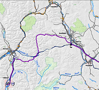
According to the maps filed with the BCEAO and made available at the open house, the new pipeline would not be twinned completely along the existing route across the mountains west of Smithers to Terrace, but would head north at Telkwa parallel to Highway 16 before making its own way through the mountains, crossing the existing pipeline at the Zymoetz River east of Terrace and then taking a westerly route toward Lakelese Lake before joining the existing pipeline corridor along Highway 37. AltaGas took over Pacific Northern Gas in the fall of 2011.
The problems currently faced by the Texas group have no affect, at this point, on the Haisla Nation investment in the BC LNG Energy Cooperative. There is already speculation in Kitimat that if the LNG Partners get into further financial difficulty, AltaGas may step in and take over. The would raise the question whether or not there would still be two floating LNG terminals on Douglas Channel, or just the one, as originally planned, but under new ownership.
In it’s project proposal PNG says
The Project will generate approximately 1800-2400 direct person years of employment during construction. Additionally, tax benefits will be generated for Kitimat and the regional districts crossed by the pipeline. PNG anticipates the project will also result in a significant reduction in natural gas transportation rates for its existing customers.
Natural gas transportation costs are a major issue in the northwest, for those costs appear to keep going up while the price of natural gas in North America is generally going down. Natural gas transportation costs in Kitimat spiked after the closure of the Methanex plant and have continued to be quite high, which is just one of the increasing burdens for residents of Kitimat on fixed or low incomes, who are not benefiting as others from the current boom town economy.
The PNG filing with the BCEAO promises consultation with both the Wet’suwet’en Council, and the Office of the Wet’suwet’en, which represents the hereditary chiefs and matriarchs, as well as other First Nations along the proposed route.
PNG Open houses for the project are scheduled for:
Vanderhoof
Friendship Centre Hall
Thursday, November 28, 2013
Terrace
Best Western Inn
Monday, December 2, 2013
Smithers
Hudson Bay Lodge
Tuesday, December 3, 2013
Burns Lake
Chamber of Commerce
Wednesday, December 4, 2013
Summit Lake
Community Hall
Thursday, December 5, 2013
Protesters march down Kingfisher Ave, during the Defend Our Coast Rally in Kitimat, Nov. 16, 2013. (Robin Rowland/Northwest Coast Energy News)
About 250 people took part in the Defend Our Coast Rally at Mount Elizabeth Secondary School, Saturday, Nov. 16, 2013. The Kitimat protest was part of what organizers said were 130 rallies across Canada to protest environmentally threatening energy developments including the Alberta bitumen sands and various pipeline projects under the labels of Defend Our Climate or Defend Our Coast.
Gerald Amos addresses the rally. (Robin Rowland/Northwest Coast Energy News)Kelly Marsh speaks about his studies that show small or mid-level pipeline breaches are inevitable. (Robin Rowland/Northwest Coast Energy News)Family at the rally. (Robin Rowland/Northwest Coast Energy News)Patricia Lange addresses the rally. (Robin Rowland/Northwest Coast Energy News)Protesters join arms, a feature of every one of the rallies across Canada. (Robin Rowland/Northwest Coast Energy News)The protest march on Kingfisher. (Robin Rowland/Northwest Coast Energy News)The protest march. (Robin Rowland/Northwest Coast Energy News)
Blacked out fishery. A new study says that fisheries protection in Canada is now tied to economics, meaning areas with lower populations, like the BC northwest, get less fisheries protection. (Fisheries magazine)
New regulations under the Fisheries Act that was revised by the Harper government’s omnibus bills go even further in gutting protection for fish habitat in Canada, according to an analysis by scientists released Friday.
The changes to Canada’s fisheries legislation “have eviscerated” the ability to protect habitat for most of the country’s fish species, the scientists, John Post, at the University of Calgary and Jeffrey Hutchings of Dalhousie University say their new study.
The study says with the Conservative government’s emphasis on prioritizing economic importance over the habitat ecology is “contrary to responsible management practices for the protection of native fishes, the act now inadvertently prioritizes habitat protection for some nonnative species—even hatchery-produced hybrids.” The study says as long as those introduced or other species are part of what the new act and regulations define as “part of a fishery,” those fish are protected, while nearby native species, not part of a fishery, have no protection.
The same economic emphasis downgrades protection for sparsely inhabitated regions (which make up most of Canada) through what the scientists call:
NO HUMANS . NO FISHERY; NO FISHERY . NO PROTECTION; NO PROTECTION . NO STEWARDSHIP
The stipulation that fish be part of, or support, a fishery will have particularly egregious consequences for species that inhabit pristine or near-pristine habitat in Canada’s vast wilderness.
Under the revised FA, fish that inhabit lakes, rivers, and streams that are not regularly visited by humans do not warrant protection. Humans are necessary to render a fish part of a fishery. No humans, no fishery, and no fish habitat protection. This can only be interpreted as meaning that the vast majority of Canada’s freshwater fishes will be deemed to not warrant habitat protection under the revised FA, even if those species are considered part of a fishery elsewhere in their range.
The changes were “politically motivated,” unsupported by scientific advice – contrary to the policy of previous governments – and are inconsistent with ecosystem-based management, fisheries biologists Post and Hutchings say.
Their comprehensive assessment, in a peer-reviewed paper titled “Gutting Canada’s Fisheries Act: No Fishery, No Fish Habitat Protection,” is published in the November edition of Fisheries, a journal of the 10,000-member American Fisheries Society.
The 2012 omnibus bill redefined fish habitat to a fishery in this clause:
No person shall carry on any work, undertaking or activity that results in serious harm to fish that are part of a commercial, recreational or Aboriginal fishery, or to fish that support such a fishery.
The two authors interpret that as meaning, that while you may be forbidden from harming the fish, there are no barriers to harming fish habitat.
… it will no longer be illegal to harmfully alter or disrupt fish habitat. The revised act only renders it illegal to cause serious harm to fish that are part of a commercial, recreational, or Aboriginal fishery or to fish that support such a fishery. “Serious harm” is defined by the act as “the death of fish or any permanent alteration to, or destruction of, fish habitat” (Fisheries Act 2013). A legal opinion prepared for the Environmental Managers Association of British Columbia concluded that serious harm does not prohibit the disruption or temporary alteration of fish habitat, concluding that many situations prohibited under the previous legislation will no longer be covered by the revised act
The new regulations proclaimed in the Canada Gazette in April 2013.
“The biggest change is that habitat protection has been removed for all species other than those that have direct economic or cultural interests, through recreational, commercial and Aboriginal fisheries,” Post says.
Before, “there used to be a blanket habitat protection for all fish species,” he says. “Now there’s a projection just for species of economic importance which, from an ecological standpoint, makes no sense.”
The study goes on to say:
The near elimination of fish habitat protection represents a clear signal that protection of habitat—the single greatest factor responsible for the decline and loss of commercial and noncommercial species on land and in water —no longer merits explicit protection under Canadian fisheries management law.
And later:
The multitude of aquatic systems that do not support a fishery, coupled with the extensive distributions of many Canadian fishes, will mean that habitat protection will not be provided for most fish species in most places.
By applying the “no humans, no fishery” criterion, the Minister of Fisheries and Oceans will have an easy time expediting applications for fish habitat destruction resulting from all manner of development. The lack of foresight inherent in the “no humans, no fishery” stipulation is also manifest by the likelihood that aquatic systems that do not support a fishery today (e.g., much of Arctic and northern Canada) might well do so in the future. But investment in future fisheries requires investment in appropriate habitat protection today. How is a fishery to develop down the road if the habitat is already gone?
Although it is well known that the Harper government muzzles scientists from speaking to the media, that apparently doesn’t mean that there isn’t “chatter” (to use the intelligence term) among fisheries scientists themselves. As the study authors report:
based on personal communications with DFO scientists and divisional managers, it appears that scientists were not consulted at all. By all accounts, DFO scientists and managers were surprised by the degree and types of changes in the revised act. According to one very highly placed science director (in a confidential communication to one of the authors), he was unaware of the March 2012 provisions in the legislation until he heard of the government’s finalized revisions on a news broadcast.
The scientists also quote earlier studies that showed the old Fisheries Act was not unduly holding up development projects.
a key reason for revising the act—a perceived need to expedite or “streamline” environmental reviews (Canada Gazette 2013)—has been shown to lack an empirical basis. There was a perception among some politicians that the act needed to be changed because it was deemed unduly obtrusive and prevented any number of activities from occurring.
The analysis by the environmental group Ecojustice showed that between 2006 and 2011, only one proposal among thousands was denied by the DFO, and only 1.6% of 1,283 convictions under the FA between 2007 and 2011 pertained to the destruction of fish habitat.
Post and Hutchings go on to say:
These scientific analyses run counter to the political discourse, which argues that environmental reviews are unduly lengthy and are bad for economic growth. In fact, review times in Canada were found to be faster, under the previous Fisheries Act, than they were in the United States. The absence of a scientific basis for statutory change in this case is a telling example of how scientific advice can constructively assist decision makers before they revise legislation.
Proponent gets to gather the data
University of Calgary fisheries biologist John Post. (Riley Brandt, University of Calgary)
Under the new regulations proclaimed in April, when an individual or company applies for an “application to undertake an activity that requires authorization by the Minister of Fisheries and Oceans” …”the primary—if not sole—responsibility for providing accurate information and data rests with the applicant, rather than with DFO habitat scientists and biologists.”
The proponent of a project has to identify whether or not “fish that are part of a commercial, recreational or Aboriginal fishery,” or “fish that support such a fishery,” at the location of the proposed work, will be the responsibility of the proponent/applicant to identify.
The two scientists say there is no way to ask what scientific standards, DFO’s or others will be applied in identifying fish that support a fishery.
There are also questions about who “will determine the scientific validity and appropriateness of each proponent’s assessment.” It could be, the paper says, the proponent themselves determining the validity of their own studies because:
There does not appear to be a requirement for the DFO to undertake an on-site inspection by DFO scientific staff to verify information provided by an applicant. This change in responsibility explains the 33% reduction in DFO staff responsible for habitat protection reported by various Canadian media in 2012. This reduction in staff can only diminish the scientific integrity and scientific credibility of DFO’s assessments of applications for the authorization of activities under 35(2)(b) of the FA that will result in the destruction of fish and fish habitat.
The study goes on to say:
The regulations confirm that the revised FA will not protect any particular species of fish. Rather, protection will be provided only to “fish that are part of a commercial, recreational or Aboriginal fishery” or “fish that support such a fishery.” This means, to take one of many examples, that Largemouth Bass (Micropterus salmoides) will be protected at a particular location if, and only if, those Largemouth Bass are considered to be part of a fishery at that location. Otherwise, Largemouth Bass will not be protected.
The scientists do acknowledge that:
It can be argued that there are positive elements to the FA revisions, such as (1) statutory recognition of the importance of recreational and Aboriginal fisheries, (2) provision for the establishment of regulations to control aquatic invasive species and prohibit their import, and (3) increased penalties and fines for contravention of the act.
They then add:
But, in our opinion, the negative consequences to Canada’s aquatic ecosystems generated by the revisions to the act outweigh these benefits, none of which actually required changes to the existing habitat protection provisions of the FA.
The scientists conclude the article by saying
Being the second largest country in the world, Canada is responsible for 20% of the globe’s fresh water, one third of its boreal forests and associated aquatic environment, and the world’s longest coastline. However, this geographical wealth comes with a responsibility to be internationally respected stewards of this vast environment. Politically motivated abrogation of the country’s national and international responsibilities to protect fish and fish habitat suggests to us that Canada might no longer be up to the task.
Haisla Nation Chief Counsellor Ellis Ross at Bish Cove, June 19, 2013. (Robin Rowland/Northwest Coast Energy News)
In 2003 I was first elected to Haisla Nation Council, and I was intent on opposing just about every economic development project coming our way, from fish farms to natural gas. Fortunately experienced councilors suggested that before I took any hard and fast positions that I consider unbiased facts and the community’s social situation.
It didn’t take long before the full extent of our community’s problems hit home, angering and saddening me at the same time. Before my political career I was one of those who applauded political speeches on unemployment, poverty, independence, and the relationship between First Nations and the Crown. But it was now clear that 30 years of speeches and government programs had changed nothing for the average Haisla person who just wanted a job. Unemployment was still at 60 per cent, housing was based on hand-outs from Ottawa, and, worst of all, substance abuse and suicides were commonplace and were destroying our people’s hopes for a brighter future.
I was fortunate to have found work outside of my reserve for most of my adult life but there are only so many jobs in depressed economies and the long term jobs were kept out of our reach by organizations associated with the corporations set up in our territory. The result was our young men and women either had to leave home for employment or stay home and accept seasonal work (UIC) or welfare. Leaving ancestral homes is a hard decision for First Nations to make. The land is connected to our protocols, our culture and to our past.
Many reasons have contributed to the demise of our peoples and communities but perhaps the foremost is the culture of dependence. Dependance in our case was from the top down; from council dependant on government funding to the individual band member being dependant on council or welfare. Our people are not lazy. The culture that preceded the non haisla culture was one of hard work to bring in food, resources and wealth. That culture has not merged so well with non haisla culture but our work ethic is the same as the non haisla culture.
If poverty is the only lifestyle you know, it is very difficult to know there is a way out, much less thinking of a way to get out of it. The individual band member that is watching development in their territory and watching the wealth being generated without having an opportunity to be a part of it is going to have resentment.
Those Nations which are succeeding — strong employment levels, healthy communities, few social ills — appear to have gained a level of independence and have done it mostly through economic development. The newer discussions are those concerning shiftwork, double time, new bosses and how paychecks will go towards the next hunting trip or holidays to vancouver or elsewhere.
We have many proposals put in front of us now that we have to sift through. When we look at these proposals we have to find accurate information in terms of impacts, benefits and feasibility. Sub topics can be right of ways, fracking, logging practices, financing, permitting, corporate structures, emissions, land ownership and the list goes on and on. We do have to consider the future but we also have to consider the present and the situation we know that our membership is in and try to put them in a position where they can help themselves.
So far, the outlook has been positive. Our people have jobs. They have hope. They are confident about their futures. The despair that comes with poverty is slowly disappearing but we have more work to do to ensure their confidence can be sustained. We know that to become a strong independent Nation, we need to have strong independent members.
We will continue to look at the contentious issues that are in front of us and will try as much as we can to resolve with both the crown and the proponent but we cant lose sight of one of the biggest reasons of why we’re doing what we do. Our members need a future.
By the way, the work we have done to date has not only assisted our members but has assisted the region and non Haislas in ways that we have not yet even started to measure yet.
Ross.
Ross later posed two comments:
Ellis Ross: got some good feedback on this but also got feedback that it was unclear on the point I was trying to make so I rewrote it. the point was in light of all the issues we have to look at, we can’t lose sight of the social factor in that some Haislas (and non Haislas) deserve the employment/contract opportunity that comes with proposed projects.
Ellis Ross: fracking, emissions, land ownership, etc… are issues that are extremely important but our people living in poverty with no hope is also an extremely important issue.
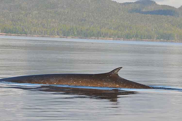
Fin whale in Squally Channel (Courtesy Chris Picard)
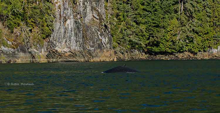
Whales are coming back to Douglas Channel.
In 2013, many Kitimat residents with long experience on the water have reported and are still reporting more sightings of both orcas and humpback whales.
Add to this a recently published scientific study that shows the number of humpbacks at the mouth of the channel near Gil Island has doubled in the past decade, with the study saying there were 137 identifiable whales in 2011.
So why are the whales returning? Chris Picard, Science Director for the Gitga’at First Nation and one of the co-authors of the study believes that answer is simple. There are, so far, three species of whales seen in the area, humpbacks, orcas and fin whales. It is only now, Picard believes, that the humpback and fin whale populations are recovering from a century of whaling.
The study estimates there were once about 15,000 humpback whales in the North Pacific when whalers began hunting the animals. That number was down to 1,400 when whale hunting was stopped in Canada in 1966.
As whale numbers increase, they are searching for the rich food sources found in the Channel, both at the mouth around near Gil Island where the study took place and as far north as the Kildala Arm and Clio Bay.
“One of the things the humpbacks like to do when they are on our coast or the Alaskan coast and that is they feed,” Picard said, “So they are really targeting areas that there is a high density of their preferred prey, krill or herring or other schooling fish, sardines in some years.”
So far the study has concentrated in Gitga’at traditional territory around the mouth of Douglas Channel near Gil Island. Picard says increasing the study area to include more of Douglas Channel is a good idea, but would require more resources than are currently available. “We’d like to continue with the study consistent with the work that we have been doing. Considering what we’re seeing in the local Douglas Channel area, Wright Sound, Gil Island, it can be very worthwhile.
“We are going to continue with our current study which involve getting to know how many humpbacks are using the area and continue with the study that we just published to see if numbers continue to increase or to see whether or if they do start to stabilize at some number,” Picard said. “With more and more proposals for increased shipping, we get to see any changes with humpback numbers that may be linked to increased shipping. We’ll continue to monitor the humpback population; not just their numbers but also their distribution in the area. We’ll continue to monitor that, again in relation to the various shipping proposals and activities that are proposed.”
It was during that study on humpbacks that the researchers from the Gitga’at Nation and the Cetacean Lab noticed the appearance of fin whales, another species that had been hit hard by whaling. (“We’ve worked very closely with the Cetacean Lab group and frankly without their help we would never have published any of this work because their data certainly was instrumental in getting the overall data set that made possible a publishable study,” Picard said.)
“We have observed is that fin whales have increased in their abundance in the area quite a bit, “ Picard said. “I can remember when we first started doing surveys, there were not too many. We’ve gone from seeing a couple over the course of an entire year. Now when we do our marine mammal surveys in the area the fin whales you pretty much see in every survey and in more and more numbers. So it’s quite encouraging to see that fin whales are becoming more abundent in the area. They were also hunted, so if you factor in the days of commercial whaling operations, that of course has stopped, so its encouraging to see that their numbers are coming back too.
The fin whales tend to be found in many of the same areas at the humpack whales are using, Caamaño Sound, Campania Sound and areas south of Gil Island. “we’ve also seen them more in the interior waters like Squally Channel, Wright Sound, Whale Channel, similar to the areas where we see the humpbacks.
“We haven’t done the same level of detailed analysis on the fin whale distribution as we have with the humpback, so it’s just my overall impression that they’re using similar habitats.
“It’s unique for fin whales to be using these more confined waters. It is my understanding that they are more of an open water species. I think that makes the area fairly unique,” he said.
Picard added it would be interesting to do a historic study to see how many fin whales were taken by whalers in the previous decades, especially in Caamaño Sound, Squally Channel and Wright Sound.
“The fact that we saw so many humpbacks relative to the size of the area, which is pretty small relative to the whole coast, so there must be a high abundance of food in the area,” Picard said.
“I’d like to get a better understanding of what is really driving the food abundance in the area. What is the oceanography in the area, what are the currents, what is driving that high area of biological activity that the whales seeming to be homing in on.”
Humpback whale in the Kildala Arm, September 14, 2013. (Robin Rowland)
That means, Picard believes, that there could be krill and juvenile herring schooling in the upper Douglas Channel and that is what is attracting the whales.
One of the next steps, Picard said, is to study social interaction among whales. “We do take identification photographs, so we get a sense of who’s hanging out with who; who is bringing their calves into the area to introduce them into what seems to be very good whale habitat,” Picard.
So one aim of a future study would be to se what role social interactions play in the increased whale sightings in the Douglas Channel. He also wants to know what role are the potential negative impacts on that whale social interaction comes noise impacts, or being struck by ships, and the potential environmental affects of oil spills. “So do these social interactions decrease as the impacts increase, does that mean there are going to be fewer whales that come into this area? Those are some of the questions we want to address.”
Carrie Mishima, a communications advisor for the Department of Fisheries and Oceans sent this statement in response to questions from Northwest Coast Energy News:
· The proposal by the Kitimat LNG project uses a relatively new technique that is expected to improve aquatic habitat in Clio Bay. The bay has been used as a log handling site for decades, resulting in areas of degraded habitat from woody debris on the seafloor. The project will cap impacted areas with inert material to restore the seafloor.
· Capping at smaller-scale sites in Canada has shown that the technique has successfully restored low-value aquatic habitat.
· The project will implement standard and project-specific measures to protect fish and aquatic habitat and will conduct a five-year monitoring program to determine how well the habitat is recovering.
· Data from the monitoring program will be used to guide future habitat reclamation at impacted habitat sites. Reference sites are being established as benchmarks against which the capped sites can be measured.
· Site-specific standards for dissolved oxygen levels will be developed for the enhanced site by sampling a control site having similar habitat parameters.
· Detailed mapping has been done to identify the best areas for the soil placement and to protect sensitive habitat such as intertidal areas, rocky substrates and eelgrass beds.
· Other required mitigation measures will include analyzing the cap material to confirm it is free of contaminants and placing this material during appropriate tidal conditions to ensure accurate placement of the cap in accordance with design plans.
Special report: Clio Bay cleanup: Controversial, complicated and costly
Log booming operations at Clio Bay, August 21, 2013. (Robin Rowland/Northwest Coast Energy News)
Chevron, the company operating the KM LNG project at Bish Cove and the Haisla Nation have proposed that marine clay from the Bish Cove construction site be used to cap more than 10,000 sunken and rotting logs in Clio Bay. Haisla Chief Counsellor Ellis Ross says he hopes that using clay to cover the logs will help remediate the environmentally degrading sections of the Bay. The proposal has brought heated controversy over the plan, both among residents of Kitimat and some members of the Haisla Nation, who say that Clio Bay is full of life and that the capping will cause irreparable damage.
An investigation by Northwest Coast Energy News shows that capping thousands of sunken logs is a lot more complicated and possibly costly than anyone has considered. It is also clear that many of the comments both supporting and opposing the Clio Bay project are based on guesses rather than the extensive scientific literature available on the subject.
Northwest Coast Energy News findings include:
In 1997, the Department of Fisheries and Oceans surveyed sunken log sites in Douglas Channel. The results, published in 2000, identified 52 sites just on Douglas Channel and the Gardner Canal that had various levels of enviromental degradation due to sunken logs. Clio Bay was not the list. The DFO scientists recomended followup studies that never happened.
Scientific studies show that degradation from sunken logs can vary greatly, even within one body of water, due to depth, currents, number of logs, and other factors. So one part of a bay can be vibrant and another part environmentally degraded due to low levels of dissolved oxygen and decaying organic material.
If KM LNG wasn’t paying for the remediation of Clio Bay, it could be very expensive. Capping sunken logs at a cove near Ketchikan, Alaska, that is the same size and shape as Clio Bay cost the US and Alaska governments and the companies involved $2,563,506 in 2000 US dollars. The total cost of the cleanup of the site which was also contaminated with pulp mill effluent was $3,964,000. The estimated cost of capping the logs in the Alaska project was $110 per cubic yard.
The Alaska project shows that a remediation project means while most of the logs in a bay or cove can be capped, in some parts of a water body, depending on currents, contamination and planned future use, the logs have to be removed and the area dredged.
Agencies such as the State of Alaska, the US Environmental Protection Agency and the US Army Corps of Engineers all recommend using “clean sand” for capping operations. Although “clay balls” have been used for capping in some cases, the US officials contacted say they had no record of large amounts of marine clay ever being used for capping. They also noted that every log capping project they were aware of happened in sites that had other forms of contamination such as pulp mill effluent.
Chevron only recently retained the environmental consulting firm Stantec to study Clio Bay. The Department of Fisheries and Oceans has told District of Kitimat Council it recently completed mapping of the seafloor at Clio Bay. The Alaska project was preceded by five years of monitoring and studies before capping and cleanup began.
A letter from Fisheries and Oceans to the District of Kitimat says that Clio Bay has been mapped and the department is planning to monitor any capping operations. However, it appears from the Department of Fisheries and Oceans website that the department has no current policies on remediation since the Conservative government passed two omnibus which weakened the country’s environmental laws. According to the website, new remediation policies are now being drafted. That means that although DFO will be monitoring the Clio Bay operation, it is uncertain what standards DFO will be using to supervise whatever happens in Clio Bay.
Northwest Coast Energy News is continuing its investigation of the sunken logs problem. Expect more stories in the days to come.
 The list of participants in the oil spill preparedness and response study released last week by the federal government shows two glaring no shows, the District of Kitimat and Rio Tinto Alcan.