Bitumen excluded from data for federal tanker study, documents reveal

Tanker risk map
Transport Canada tanker report map shows current risk for spills in BC (Transport Canada)


Genivar report
Cover of Genivar tanker report (Transport Canada)


The possible effects of a bitumen spill on Pacific waters were not considered in the oil response preparedness report released last week by the Harper government, the background data study reveals.

The consulting firm that did the study for Transport Canada, Genivar Inc, had no reliable data on the effect of a bitumen tanker disaster—because, so far, there has been no major ocean disaster involving diluted bitumen.

Instead, Genivar, based its findings on potential hazards and response on existing data on crude oil spills.

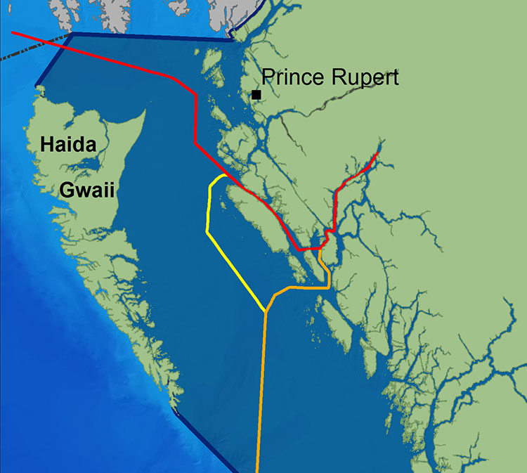
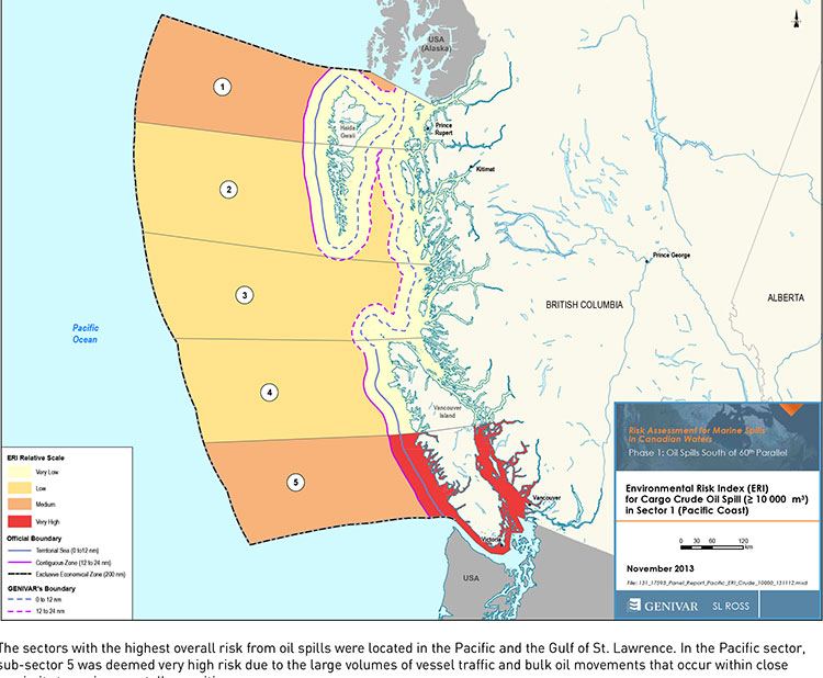
The Genivar study, however, does warn, that if the Enbridge Northern Gateway project does go ahead,  the spill risk from diluted bitumen carrying tankers in Douglas Channel and along the north Pacific coast will jump from “low” or “medium” to “very high.” If the twinning of the Kinder Morgan pipeline goes ahead, then the risk in Vancouver also jumps to “very high.”

The question of how bitumen might behave in the cold and choppy waters of the North Pacific was hotly debated during the Northern Gateway Joint Review hearings earlier this year. Enbridge Northern Gateway based its position on laboratory studies, studies that were challenged by environmental and First Nations intervenors, pointing both to the unknowns of the ocean environment and the continuing problems Enbridge has in cleaning up the spill in the Kalamazoo River in Michigan.

Genivar tried to base its report to Transport Canada on existing data on oil spills and related hazards. What it found instead is that that there are often gaping holes in the reporting and monitoring of oil spills world wide, especially small and medium sized spills.

Lack of data also meant that Genivar had little to go on when it calculated the effect on an oil spill on key areas of interest to northwest British Columbia, the recreational fishery and tourism.
Genivar, however, did uncover disturbing data about the long term effects of oil spills, studies that show even minute amounts of remaining oil can still disrupt the marine environment 40 years after an event.

The Genivar report, Risk Assessment for Marine Spills in Canadian Waters Phase 1: Oil Spills South of 60th Parallel, was completed in November, then passed on to the “expert panel” that released their own report: A Review of Canada’s Ship-source Oil Spill Preparedness and Response Regime — Setting the Course for the Future. That second report was based not only on the data provided by Genivar but on the expertise of three panel members, their visits to some locations and input from government, industry, First Nations and municipalities.

Transport Minister Lisa Raitt and Natural Resources Minister Joe Oliver unveiled the second report at a glitzy media event  in Vancouver on Tuesday, December 10. At that time the expert panel report was released to the media along with an abstract of the data.

The actual data report was not posted; it had to be requested through the Transport Canada website, which is how Northwest Coast Energy News obtained the background study.

High risk for Kitimat

Transport Canada tanker report
Expert panel tanker risk assessment report cover (Transport Canada)

The expert panel found “a very high risk” of oil spills in two areas of the Pacific Coast, in the north around the ports of Kitimat and Prince Rupert and in the heavy ocean traffic area of southern British Columbia, especially Port Metro Vancouver and into Washington State.

The expert panel made 45 recommendations that covered a wide range of issues including eliminating the present $161-million liability limit for each spill and replacing it with unlimited liability for polluters, annual spill training involving the Canadian Coast Guard, Environment Canada, provincial and local authorities and the private sector, increased and improved annual spill training exercises, basing risk assessment on local geography and conditions and faster emergency responses to spills.

The expert panel calls for greatly increased research on the ocean environment at a time that Harper government has been gutting environmental research across Canada, while spinning that its policies are “science based.”

The science and technology around both the movement of oil and spill response has advanced significantly over the past several decades. We feel that while some aspects of the Regime have kept pace with these developments, in some areas, Canada has fallen behind world-leading countries like Norway and France. This can be attributed to a general lack of investment in research and development as well as the lack of coordination between industry and government over research priorities.

The Government of Canada should work closely with industry to establish a national research and development program for oil spill preparedness and response. The program should be co-funded by industry and the Government, and the research priorities should be set through a collaborative process that involves academia, where possible. Like the Regime itself, we view this program as a partnership between industry and government.

We envision that this program would also seek to leverage the work being done internationally on oil spill preparedness and response. The program should seek to establish partnerships with other world-leading countries in order to stay current on international advances and new technologies.

The expert panel, however, does not say how the federal government is expected to pay for meeting BC Premier Christy Clark’s condition for a “world class” spill prevention and response system at a time that Finance Minister Jim Flaherty is determined to balance the budget and the Harper government is continuing to cut back government services.

Bitumen excluded

On bitumen, the Genivar data study says:

Modified bitumen products represent the majority of the “crude carried as cargo” in
Pacific sub-sector 5. They are not modelled as a separate category in this spill behaviour analysis but are represented as “persistent crude”.

Changes in spill behaviour depend to some extent on the environmental conditions at the time of the spill, as described in greater detail below. However, over the range of wind and sea conditions typically experienced in the Canadian marine environment, changes in oil properties are not overly sensitive to variations in climatic values, so a single set of wind and sea conditions will be used in the analysis.

The idea that “changes in oil properties” not being sensitive to variations in climate was also frequently challenged before the Joint Review Panel.

On the increase in traffic volume if the Northern Gateway project goes ahead, the Genivar report says.

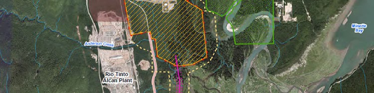
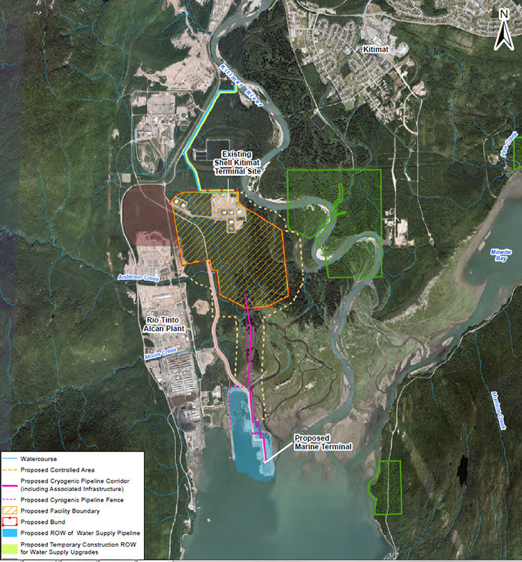
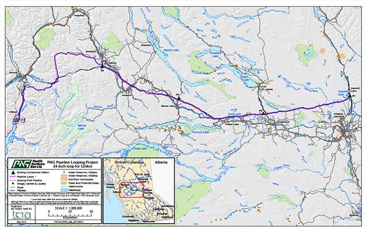
Enbridge Inc. has proposed to construct a marine terminal at Kitimat, B.C. and a dual pipeline from the terminal to oil sands production in northern Alberta. The terminal would handle up to 193,000 barrels/day of imported diluents (i.e., low-gravity condensate) that would be piped to Alberta and used to dilute bitumen to enhance its flow properties. The diluted bitumen would then be piped to Kitimat at rates up to 525,000 barrels/day that would be shipped by tanker to export to markets in Asia and California.

At full capacity, the import of diluent and export of diluted bitumen would total up to 35 Mt/year. This amount is comparable to the currently-shipped volume in the Pacific sector related to volumes being exported from Vancouver and related to volumes being exported from the Alaskan to Washington State trade.

It goes on to say that the current tanker traffic on the north Pacific coast “has negligible risk in the near shore and intermediate zones, but significant potential spill frequency in the deep-sea zone related to the Alaskan trade.” Similarly, according to Genivar the environmental risk in the region “currently ranges from ‘medium’ to “very low” from near shore to deep-sea zones, respectively…. mainly driven by a combination of physical and biological features.”

The increase in traffic from Northern Gateway would likely increase the environmental risks. The the near shore risk from would jump from “very low” to “very high.” For the largest spill category, deep-sea risk would likely increase from “low” to “medium.”

No data on recreational or traditional First Nations fishery

To study the effect on an oil spill on the fishery, Genivar used data from the Department of Fisheries and Oceans as the provinces to gauge “the port value of commercial fishing and the value of the fish, shellfish and aquaculture” in each zone it studied and then compared it to the the national averages for commercial fishery. Those figures included any commercial fishery by First Nations.

But Genivar noted, there is no reliable data on either the recreational fishery or the First Nations traditional, food, social and ceremonial fishery, saying:

It is important to highlight that this indicator does not consider recreational or traditional fishing. The importance of this industry is notable and an oil spill could damage the recreational fishing stock as well. However, the absence of comparable data and the fact that this study is restricted to federal and international data, and some provincial data from Quebec and Ontario for commercial fisheries, limits the ability to include recreational fishing… Nevertheless, as an absolute index, it will provide an overall vulnerability in the event of an oil spill.

The ongoing impact of cutbacks at Fisheries and Oceans has had a continuing impact on the northwest, especially in the controversial halibut recreational fishery, where DFO has admitted that it is basically guessing the size of each year’s recreational halibut catch.

Tourism

Genivar also notes that lack of reliable data on the effect on a oil spill on tourism. The consultants go so far as to say one of the indicators they will use to measure the effect of any oil spill on tourism would come from “data extracted from the 2011 National Household Survey at the census division level and the accommodation and food services data will be used.”

The “National Household Survey” is also known as the long form census and it is the National Household Survey that the Harper government made voluntary rather mandatory, decreasing the reliability of the data. Global News recently analyzed those who had contributed to the survey and found that it poor people, the very rich and people in low population areas were least likely to fill out the voluntary census—which means the data for northwest BC is likely highly unreliable from the 2011 survey even though “The census divisions in coastal regions will be selected for each of the sub-sectors. This method will express the economic vulnerability of each sub-sector to a potential collapse in tourism following a spill.”

Despite the importance of cruise ship traffic on the west coast, Genivar notes, “In Canada, data for passenger vessels were unavailable.”

It also notes that “this study does not specifically take into account national parks and other landmarks, since their influence on tourism is indirectly included in the tourism employment
intensity index” so that Genivar could create what it calls the Human-Use Resource Index (HRI), even though that index appears to be based on incomplete data.

Commentary: In the tanker study, the District of Kitimat was missing in action

kitimatlogoThe list of participants in the oil spill preparedness and response study released last week by the federal government shows two glaring no shows, the District of Kitimat and Rio Tinto Alcan.
The Haisla Nation and the Gitga’at Nation did provide written submissions to the panel.

The expert panel was set up by the federal government to review “oil handling facilities and ship-source oil spill preparedness and response.” The expert panel was to review the “structure, functionality and the overall efficiency and effectiveness of the system, as well as analyzing the requirements for hazardous and noxious substances, including liquefied natural gas.”

Transport Canada tanker report
Expert panel tanker risk assessment report cover (Transport Canada)

As well as commissioning the Genivar report on the state of oil spill preparedness and consequences, the panel interviewed stakeholders and visited a few key locations, including Port Metro Vancouver.

The panel also invited any interested groups to submit documents or their own views to be taken into consideration.

Among the stakeholders interviewed by the panel were companies and organizations very familiar to Kitimat; Chevron and Shell, main partners in two of the LNG projects; Enbridge, which has proposed the Northern Gateway Pipeline and Kinder Morgan which has proposed expanding the dilbit pipeline on the Lower Mainland. Other stakeholders included Coastal First Nations, the Prince Rupert Port Authority, SMIT Marine and the Vancouver Port Authority.

As well as the Haisla and the Gitga’at, five west coast municipalities submitted their own reports to the tanker panel, both the city and districts of North Vancouver, the city of Richmond, the District of Ucluelet and the District of West Vancouver. San Juan County in Washington State also made a submission to the panel. So did the Prince Rupert and Vancouver Port authorities.

Chevron, Enbridge, Imperial Oil, Kinder Morgan, Pacific Northwest LNG, Seaspan Marine, and the Union of BC Municipalities, among others also submitted their views to the panel.

So why didn’t the District of Kitimat participate? When it came to the Enbridge Northern Gateway Joint Review, the mayor and council always maintained their neutrality motion meant that the District would not be an active participant. That was always a short sighted viewpoint. The District should have participated actively in the JRP in such a way as to protect the region’s interests where necessary while remaining neutral. If the District of Kitimat sat out the tanker panel because of the Northern Gateway neutrality policy, that was no excuse, because the expert panel’s mandate specifically included LNG.

Tanker traffic is a potential threat to the San Juan Islands (the Gulf Islands on the American side of the border). It is astounding that San Juan County would think that the Canadian tanker panel was important enough to make a submission and the District of Kitimat did not.

RTA logoWhat about Rio Tinto Alcan? Kitimat has been a private port for 60 years, run first by Alcan and then by Rio Tinto Alcan. Why wasn’t RTA asked to participate as a stakeholder? Why didn’t RTA make a submission? Those who are pushing the Northern Gateway terminal always like to say that tankers have been calling at Kitimat for those 60 years. That is true. Of course, none of those tankers have been the Very Large Crude Carriers proposed by Northern Gateway. However, those 60 years means that RTA has the expertise on the Port of Kitimat and Douglas Channel. RTA probably has important data that could have helped both the expert panel and Genivar (which pointed out the paucity of data on small and medium sized tankers). In not participating in the tanker panel submissions and possibly not providing valuable data on Douglas Channel, RTA neglected its social responsibility both to the community of Kitimat and the rest of the province of British Columbia.

Editorial: Once again the National Energy Board shows its contempt for British Columbia

Second Update December 10- NEB refuses to release JRP report in BC

The Globe and Mail reports Dec. 10, 2013

The National Energy Board says releasing its decisions in Calgary is standard practice regardless of where in Canada the project is located, and it will not make an exception for its report on the controversial $6.5-billion Northern Gateway pipeline proposal.

Apparently the NEB doesn’t trust reporters in BC to act as professionals. Also, as usual the stock market is more important than the people of BC.

NEB spokesperson Sarah Kiley told the Globe the board ruled out simultaneous lock-ups in Alberta and British Columbia.

“As far as hosting multiple media lock-ups, we need to make absolutely sure that the report is not inadvertently released before the markets close,” Ms. Kiley said. “This becomes more challenging if there are multiple events due to things like the need to ship reports.”

Because the ruling will affect markets, she said the report must be kept confidential until they close on the day of release.


A couple of years ago, on a visit to the Lower Mainland, I was speaking to man who was considering making a 10 minute comment before the Northern Gateway Joint Review panel. In the end, this man, who is by no means a radical environmentalist, just someone worried about the future, decided not to testify, telling me: “The National Energy Board is nothing more than an extension of the Petroleum Club.”

Once again today, the National Energy Board showed its contempt for British Columbia and proved my source’s belief that it is nothing more than an extension of the Petroleum Club.

Vancouver radio station News 1130 made a routine inquiry to the NEB about a reporters’ “lockup” on the day that the JRP decision is released. A “lockup” allows the media to read an embargoed report a few hours in advance so that  at the moment it is officially released, it can print or broadcast an accurate account of a government report.

News 1130 was told by the NEB that there would be no lockup in British Columbia, only reporters in Calgary, the home of the NEB, will have that opportunity, because “logistics did not work out for a lock-up” in Vancouver.

(Reporters who work along the actual pipeline route in the north are even farther off the NEB radar. The Calgary lockup will leave northerners to figure out what the JRP decision actually means from reports from Alberta-based journalists. The history of the past few years has proven that most Alberta-based reporters have little interest or knowledge of the concerns of northwest British Columbia.)

Before the JRP hearings began in January, 2012, a well-known northern First Nations leader predicted all this in a background conversation. He noted that there was no representation from British Columbia on the Joint Review Panel. The JRP had two members from Alberta, chair Sheila Leggett, and member Kenneth Bateman, while the “First Nations member,” Hans Matthews, was from Ontario. The First Nations leader, who would have to appear before the JRP, privately called them “flatlanders” with no knowledge of B.C.

He was right.

Even before that conversation, the Joint Review Panel blundered in its first appearance in Kitimat, the preliminary hearing at Riverlodge on August 30, 2010, by offending the Haisla Nation with a schedule of appearances crafted in Calgary that ignored that Kitimat is on Haisla traditional territory and put then Chief Counsellor Dolores Pollard well down on the schedule. That hearing was held up for about half an hour while the JRP scrambled to undo their mistake.

While the JRP did finally learn to respect the customs of BC’s First Nations, and the panel was often hamstrung by arcane and obsolete rules of procedure, the panel too often proved far too inflexible in understanding the issues along the pipeline route and up and down the coast.

The most recent example was the JRP’s refusal to consider the recent evidence from both scientists and Fisheries and Oceans about the growing importance of humpback whales in Douglas Channel. The JRP’s excuse was that the window for evidence had closed. If the Northern Gateway actually goes ahead, Enbridge speaks about the 30-year-life of the project. Yet the JRP’s continuing inflexibility acts as if all the key issues can be decided by the December 30 deadline and after that everything will be just fine.

In the past few weeks, report after report has been released on projects that will change the lives of the people of the northwestern British Columbia. The media of the northwest, all with very limited budgets, have been ignored time and time again.

Take another example from today. In March, the federal government flew its First Nations negotiator Douglas Eyford and Natural Resources Minister Joe Oliver to Terrace to announce the beginning of the Eyford’s meetings with BC First Nations (while at the same time Oliver didn’t bother to visit Kitimat). This morning, the Eyford report was released at a press event in media-rich Vancouver. For the release of the report, the northwest didn’t count.

On Tuesday, the federal government also used Vancouver to release a report on tanker traffic. While Vancouver is also vulnerable to tanker problems, the feds considered their message could be carried best by the mainstream major metro media. Again, no one bothered with the northwest, where the tankers will be sailing along the coast and up and down Douglas Channel.

A few weeks ago, BC Premier Christy Clark announced her agreement with Alberta Premier Alison Redford on the compensation issue, one of her five conditions for heavy oil development in the province. Clark solved the political dispute with Alberta by handing off the compensation issue from the province to the energy industry with absolutely no guarantee that the energy companies will actually offer compensation for crossing BC. Northern reporters could listen in to an audio feed of the news conference from the BC government website, but could not ask questions.

In the 21st century, of course, these news conferences are not about presenting factual information; the news conferences are about getting out a government message track, so questions from reporters who actually know about issues are not wanted.

The Joint Review Panel (with the NEB one of the “joint” partners) is supposedly, on paper, a quasi-judicial body, independent of the government.

If the JRP wants to salvage even a bit of its crumbling credibility for its Northern Gateway decision, it will show that it respects British Columbia. The means holding two additional lockups. If Terrace was good enough for the final arguments, and a central location for the northwest, one lockup should be held in Terrace, so northerners can read reporting by northwest-based reporters. The second, of course, should be in Vancouver for the province’s major media centre.

Given the record of the past two years, don’t hold your breath, time and time again the bureaucratic priorities and the fact that the NEB is thoroughly embedded in the energy culture of Alberta, it is likely that the release of the report sometime in the coming weeks will be Alberta-centric and will prove my source right, that the NEB is nothing more than that extension of the Petroleum Club.


Update: The Globe and Mail has confirmed News1130’s report in National Energy Board sidestepping B.C. on Northern Gateway.

The board plans to hold a media lock-up in Calgary, but does not have similar plans to brief reporters in British Columbia, says an official with the independent federal agency established to regulate international and interprovincial issues around the electrical utility, gas and oil sectors.

Board spokesperson Sarah Kiley said Thursday that the board recognizes there is an interest in B.C. in the subject, and said there is no final plan yet.

The Globe was unable to get a statement from the Liberal government of BC but for the opposition,Spencer Chandra Herbert (Vancouver-West End) said, the energy board should not be hiding out in Calgary when they announce what they are going to do, regardless of whether they approve or reject the project.

“You would think they would have the ability and respect for B.C. to host it here and explain whatever decision they make here to B.C. media and intervenors,” he said.

“We’re worthy of that respect.”

LNG Canada aims to be “first out of the gate” in the rush to develop in Kitimat

LNG Canada meeting
Residents of Kitimat discuss the proposed LNG Canada facility with company officials at the Rod and Gun, Nov. 27, 2013 (Robin Rowland/Northwest Coast Energy News)

LNG Canada says it wants to be “first out of the gate” in the competitive race to send BC’s liquified natural gas to Asian markets.

The company held a well attended open house at the Kitimat Rod and Gun on November 27, with the usual array of posters and experts, to mark the beginning of the environmental assessment process for what is formally called the “LNG Canada Export Terminal Project.:

The LNG Canada Export Project is a partnership of Shell,Canada Energy, Diamond LNG Canada, an (“affiliate” of Mitsubishi), Korea Gas Corporation and Phoenix Energy (an “affiliate” of PetroChina) filed a draft application for an Environmental Assessment Certificate with the BC Environmental Assessment Office and Canadian Environmental Assessment Agency on November 8. The 30-day public comment period on the draft Application Information Requirements started on November 13, 2013 and end on December 13, 2013.

The extensive documentation can be downloaded in PDF format from the BCEAO site. The documents can also be viewed at the Kitimat and Terrace Public Libraries and the LNG Canada office in Kitimat at the old Methanex site.

“What we want to be able to do is actually to provide information in a way that we can provide a lot of conversation with the community, so we can really have a dialogue, to give them a place where they know than go to get answers. We do believe that we can be the best project in British Columbia, the only way we can do that is if we have the support of the community,” LNG Canada’s Susannah Pierce told reporters.

“We would like to be first out of the gate. This is a competitive industry and we’re not just competing in terms of providing Canadian gas to the Asian markets, we’re competing with everyone else for the opportunity to deliver product to market.”

The application says that the all-important Financial Investment Decision will likely be “made mid-decade followed by 4-5 years of construction with commissioning of the first phase to follow.”

The first phase would have a first phase of about 12 million tonnes a year of LNG, with another MTPA (million tonnes per anum) in “one or two subsequent phases.”

Federal, provincial and municipal governments or agencies, First Nations and the general public have the ability to comment on the proposal.

An aerial photo map included in the application shows the footprint of the proposed LNG Canada operation. Although the LNG Canada project is based at the old Methanex plant, the map shows that the LNG plant will take up a much larger area than the original. The old Methanex access road would be widened parallel to the Rio Tinto Alcan smelter and a Cyrogenic Pipeline would cross the Kitimat River estuary to the marine terminal.

LNG Canada footprint map
A map provided by LNG Canada shows the potential footprint of the liquifaction facility and marine terminal next to the Rio Tinto Alcan aluminum smelter. (LNG Canada)

The scope of the project includes one possibly controversial item: “Onsite power generation,” where natural gas would be used to power the cooling equipment to turn the gas into LNG.

The assessment will also look the natural gas receiving and production facility; “a marine terminal able to accomodate two LNG carriers each with capacity up to 265,000 cubic metres (approximately 122,000 DWT) and a materials offloading area; supporting infrastructure and the construction facilities.

The environmental assessment will examine air quality, green house gas management, the acoustic environment (the noise created by the project), soil, vegetation, wildlife, freshwater, esturine fish and habitat, marine resources including fish and fish habitat and marine mammals, water and ground water quality.

The economic and social assessment includes infrastructure, land use, “visual quality,” odour, marine transportation and use, community health and well being, archaeological heritage and human health.

LNG Canada meeting
District of Kitimat Council member Mario Feldhoff discusses the LNG Canada project with a company official at the Open House at the Rod and Gun, Nov. 27, 2013. (Robin Rowland/Northwest Coast Energy News)

The assessment process will also “assess potential cumulative economic, health, social and heritage effects from the Project…interacting cumulatively with similar effects of past, present and future projects activities. The current table of projects to be considered for cumulative effects include the Rio Tinto Alcan Aluminum Smelter and Modernization Project, the Kitimat LNG and Douglas LNG terminals, the possible Enbridge Northern Gateway porject, the new use for the old Methanex and Cenovus operations, the operations at the Sand Hill, the former Moon Bay and current MK Bay Marinas.

Projects further away include LNG and other projects and associated pipelines at Prince Rupert, including expansion of the current ports and the redevelopment of Watson Island. Cruise ship and BC ferry operations will be only considered where they impact the shipping routes. Any forestry operations will also only be considered where they impact the project.

Updated to fix typos, including spelling of Feldhoff

Commentary: The earthshaking difference between Enbridge and LNG

Joint Review Panel
The Northern Gateway Joint Review panel, Kenneth Bateman, Sheila Leggett and Hans Matthews, listen to final arguments in Terrace, June 17, 2013. (Robin Rowland/Northwest Coast Energy News)

Buried deep in the LNG Canada environmental assessment application, a reader will find a key difference in attitude with at least one of the group of companies planning liquified natural gas development in the northwest and Enbridge Northern Gateway.

It’s an earthshaking difference, since it’s all about earthquakes.

The documents filed by LNG Canada with the BC Environmental Assessment Office and the Canadian Environmental Assessment Agency acknowledge that there is a possibility of an earthquake (a one in 2,475 year event) at the LNG terminal site.

Northwestern British Columbia was shaken by two major earthquakes in the months before the Joint Review Panel concluded its hearings in Terrace. Both were far from Kitimat, but felt across the District. On October 27, 2012, there was a magnitude 7.8 earthquake on the Queen Charlotte Fault off Haida Gwaii. That quake triggered a tsunami warning, although the actual tsunami was generally limited to the coast of Haida Gwaii. Both landline and mobile phone service in Kitimat was briefly disrupted by both the quake and overloads on the system. Kitimat was also shaken by the 7.5 magnitude earthquake centered at Craig, Alaska a few weeks later on January 9, 2013.

With the exception of one vague reference in its final argument documents presented to the Joint Review Panel, Enbridge has stubbornly refused to consider any seismic risk to the region.

That was the company’s policy long before the October. 27, 2012 Haida Gwaii earthquake and was Enbridge policy after October 27, 2012.

In a public meeting in Kitimat on September 20, 2011, more than a year before the Haida Gwaii earthquake, John Carruthers, Northern Gateway president, insisted to skeptical questioners at a community forum at Mount Elizabeth Theatre that there was no earthquake danger to the proposed Northern Gateway pipeline and bitumen terminal in Kitimat.  One of the questioners, Danny Nunes, of Kitimat, asked could the pipes withstand an earthquake? Carruthers repeated that Kitimat was not in an earthquake zone, that the fault was off Haida Gwaii and so would not affect Kitimat.

After the September, 2011 meeting, I asked Carruthers if Enbridge knew about the March 27,1964 “Good Friday” magnitude 9.2 Alaska earthquake that, because of its high magnitude, had caused major shaking in Kitimat. That earthquake destroyed much of Anchorage and triggered tsunamis that caused damage and death across Alaska and in parts of British Columbia, Oregon and California.

Carruthers promised to get back to me and never did.

On June 17, 2013, six months after the Craig, Alaska earthquake, in his opening summation before the Joint Review Panel, Richard Neufeld, lead lawyer for Northern Gateway, stayed on message track, telling the JRP, referring to pipelines: “The route is not seismically unstable. The seismic risk along the pipeline right-of-way is low, with only a few locations of moderate risk encountered, none of which are within the Haisla territory.”

That brought a gasp from spectators in the room, or at least those who had felt the October and January earthquakes.

The following day, June 18, Murray Minchin of Douglas Channel Watch found an anomaly in the Enbridge documentation, arguing in the group’s summation:

“The Proponent’s written final argument gets on shaky ground regarding design and construction of the storage tanks on a ridge beside Douglas Channel in paragraph 249 where they say:

“‘It also involves the safe construction and operation of the Kitimat terminal in Kitimat Arm in an area subject to seismic activity which encompasses both terrestrial and marine components.’

“Now, that’s interesting because isn’t that the first time — the first admission by the Proponent in a little over 10,000 pages of documents that the area they intend to build their project is in a seismically-active area?

“Haven’t they been telling us all along to this point that the only seismic concerns would be from the distant Queen Charlotte fault off of Haida Gwaii?

“Now, this completely contradicts Mr. Neufeld’s statement yesterday where he described the Project area as not “seismically unstable”. So what is it? This is their final argument and they’re contradicting themselves.”

Minchin went on to quote from the Enbridge argument: “’Seismic conditions in the project area have also been addressed.’

“Well, really? Is that a truthful statement, considering Natural Resources Canada has only submitted a preliminary report concerning a 50-kilometre fault line and massive submarine landslides they accidentally discovered last year in Douglas Channel while doing a modern survey of the Channel for navigation hazards.

“How can the Proponent claim to have adequately addressed seismic forces in their design of this Project when they don’t know what those forces are or for what duration they may be subjected to those forces.

“Has there ever been a paleoseismological study in the Project area to establish past earthquake or tsunami history?

“Wouldn’t it be in the best interest of the Proponent, the Panel and Canadians to know the risks before 1.3 billion litres of liquid petroleum products are allowed to be stored on a low ridge right beside Douglas Channel?”

In his final rebuttal on June 24, Neufeld did not address the contradictions that Minchin had pointed out.

Compare Enbridge’s attitude to the view of LNG Canada, which at very least, appears willing to consider that major events could have adverse consequences on the terminal and liquifaction facilities.

    • The first one is a bit puzzling to Kitimat residents “A 1 in 100 year 24 hour rain event,” after all the town often gets rain for 24 hours straight or more fairly often.
    • The second, 1 in 200 year flood of the Kitimat River. Flooding has always been a concern and will be even more so, because as the pipelines come into town, whether natural gas or bitumen, those pipelines will be close to the river bank.
    • The 1 in 2,475 year seismic event. That figure is probably correct for a local event given the geology of the Kitimat Valley—unless, of course, the fault line discovered by the Geological Survey of Canada on Hawksbury Island proves to be a potential danger.
    • A tsunami.
    • Change in flow of the Kitimat River.
    • Even more interesting is that LNG Canada is willing to consider possible effects of climate change on the project, saying: “Predicted climate change effects during the project lifecycle on sea-level rise, precipitation and temperature. Where relevant and possible, the implications of such climate induced changes to the extreme weather events given above will also be addressed.”

.

Although the hydrocarbon industry as a whole is reluctant to acknowledge climate change, it appears that on a practical level, the LNG Canada partners, if they are about to invest billions of dollars in a natural gas liquifaction plant and marine terminal, will certainly take steps to protect that specific investment from the effects of climate change.

On the other hand, the National Energy Board, as matter of policy and the Northern Gateway Joint Review Panel, both still stubbornly refuse to even consider any effects of climate change, even possible effects locally on a specific project application.

The Joint Review Panel decision on the Northern Gateway is expected sometime in the next three weeks. While most reports seem to indicate that the decision will be released after Christmas before the Dec. 30 deadline, there has been recent media speculation that the decision could be released next week.

In the meantime, Enbridge has pulled out all stops in a public relations campaign to build support for the Northern Gateway. While a recent poll indicates that advertising campaign may be having some success in the Lower Mainland, the same poll showed that 65 per cent of northern BC residents oppose or strongly oppose the Northern Gateway.

The problem for Enbridge is that the new public relations campaign is repeating the blunders that began when they first proposed Northern Gateway in 2005. There have been meetings across the northwest, but those meetings have been invitation only affairs at chambers of commerce and community advisory boards, with possible opponents or skeptics and media perceived as critical of Enbridge not invited. So Enbridge still wants to control the message and will only talk to friendly gatherings.

Then there are the television spots featuring Janet Holder, the Enbridge vice president in charge of Northern Gateway, supposedly showing her commitment to wilderness. Those commercials would have had more credibility if the agency had produced the ads with actual video of Holder walking through the bush, rather than shooting the spots in front of a green screen in a studio, with pristine wilderness stock video in the background, and Holder acting as if she was a model for an adventure clothing company rather than  vice president of a pipeline company.

Right-wing business columnists in Toronto and the countless Albertans fume at the so-called “hypocrisy” of British Columbians who support LNG and oppose bitumen.

Of course, those critics didn’t feel the earth move under their feet.  The critics don’t see the difference between natural gas and bitumen, differences very clear to the people of British Columbia.

It’s more than the fact, that so far, the LNG projects have been relatively open and willing to talk to potential adversaries,  as Chevron has done on the controversial Clio Bay project; more than the fact that if even a fraction of the LNG projects go ahead, the money coming into northwestern BC means that the handful of permanent jobs promised by Enbridge will be literally a drop in a bucket of warm bitumen.

Although there are many other environmental issues on the Northern Gateway project, the fact the potential for earthquakes in Kitimat is brushed off by Enbridge while LNG Canada is at least willing to consider the problem, sums it all up.


Updated with link to Sept. 2011  questions and answers


BC calls for input on conservation plan for Ashdown Island, one of the “disappeared” on Douglas Channel

Ashdown Island
Sea lions basking on Ashdown Island (BC Parks)

BC Parks and the Gitga’at First Nation are calling for public input as they development a management plan for the K’nabiyaaxl/Ashdown Island Conservancy at the mouth of Douglas Channel.

BC Parks describes the area as:

K’nabiyaaxl/Ashdown Conservancy covers 727 hectares of marine and uplands ecosystem on the northwest coast of British Columbia, south of Gil Island. The conservancy is 40 kilometres south of Hartley Bay and 120 kilometres southwest of Kitimat. The conservancy is in the traditional territory of the Gitga’at First Nation.

The public has until December 9 to read the management plan and file comments with BC Parks and the Gitga’at Nation.

Although not well known outside the Kitimat region, Ashdown Island did receive some measure of fame because it was one of the islands that disappeared from Enbridge’s promotional animation of the tanker route for diluted bitumen from Kitimat to Asia if the controversial Northern Gateway project goes ahead. As well as a haven for wildlife, Ashdown is known as a prime halibut fishing area.

Ashdown Island
Ashdown Island study area (BC Parks)

Ashdown Island is on the proposed “Southern Approach” for Enbridge’s tanker traffic routes.

Tanker routes (Wikipedia from Living Oceans)


Recent studies by both Fisheries and Oceans and scientists have identified the area as “critical habitat” for the rebounding humpback whale population visiting the BC Coast. The Northern Gateway Joint Review panel recently refused to consider those studies because they were released after the deadline for filing evidence.

The BC management plan notes:

The area and nearby waters have been and continue to be intensively used by the Gitga’at people for cultural, social and economic purposes. In Tsimshian language (Sm’algyax), K’nabiyaaxl means “place where cliff” – which is located on the west side of Ashdown Island.

The conservancy encompasses all of Ashdown Island and the foreshore area
and land covered by water within 200 metres of the high tide line. It
has high intertidal values, especially for seaweed, and contains an important
Steller Sea Lion haulout. The waters around the island support important Gitga’at
community fisheries.


Although in Gitga’at traditional territory, the plan notes that the Haisla, the Kitasoo community of Klemtu; and Gitxaala community of Kitkatla on Dolphin Island should be consulted.

It goes on to say:

The conservancy protects an entire small island representative of the Hecate Lowlands Ecosection. The island’s foreshore marine environments include high value intertidal areas which provide high value habitat for important marine wildlife species and migratory birds. The conservancy also protects a haulout for Stellar Sea Lions (Eumetopias jubatus), a species of concern (provincially blue- listed3)…

Stellar Sea Lions use small islets off the south end of Ashdown Island as a winter
haulout, with up to 12 pups and 107 adults observed

The plans lists the Humpback Whale (Blue-listed, S1N); the. Killer Whale (Red- or Blue-listed, S2 or S3 depending on sub-species); and the Fin Whale; as Ashdown Island species at risk. (SARA species schedule procedure site)

As well:

The conservancy contains seven hectares of potential Marbled Murrelet habitat
which, although small, may provide important habitat when combined with core
Marbled Murrelet habitat in nearby areas.

K’nabiyaaxl’s remote location provides an excellent opportunity for maintaining
biological diversity and natural environment values. This habitat should not be
disturbed by conservancy use and development.

The island and the near shore are also part of the Gitga’at’s rich cultural heritage.

The conservancy is near the seasonal Gitga’at village camp of K’yel. The Gitga’at
travel in the spring from Hartley Bay to K’yel, which they use as a base for conducting intensive marine and intertidal harvesting and hunting activity.

Since time immemorial, the Gitga’at people have harvested fish and marine
mammal species in waters adjacent to K’nabiyaaxl. They also collect seaweed,
plants and berries from intertidal and upland areas on the island.

Archaeological sites are known to exist in the area. That the BC Archaeological
Branch does not have archaeological sites registered in the conservancy is not
indicative of the rich history of Gitga’at occupancy and use of K’nabiyaaxl.

Second floating LNG terminal eyed for Kitimat at Douglas Channel log sort

PNG Pipeline Looping Project map (PNG)

A second floating liquified natural gas terminal may be planned for Kitimat, Northwest Coast Energy News has learned.

According to multiple sources in Kitimat, Altagas, the parent company of Pacific Northern Gas plans the terminal at the old log sort site on Douglas Channel, where the barge carrying the liquifaction equipment would likely be moored next door to the already planned BC LNG/Douglas Channel Partners LNG project which would be served by gas delivered by the PNG pipeline system.

Pacific Northern Gas has filed an application with the BC Environmental Assessment Office to construct and operate an approximately 525 kilometre, 610 millimetre (24 inch) diameter natural gas pipeline from the natural gas hub at Summit Lake, near Prince George, to Kitimat that would loop or twin the existing PNG existing natural gas pipeline.

The application to the BCEAO says: “The proposed Project would supply natural gas to proposed liquefied natural gas (LNG) export facilities as well as the Proponent’s existing customers. The proposed Project would include the replacement of four existing compressor stations and would have an initial capacity of 600 million standard cubic feet per day.”

PNG Open House
PNG Pipeline Looping Project Open House at Tamitik. Nov. 26, 2013. (Robin Rowland/Northwest Coast Energy News)

On Tuesday, November 26, Pacific Northern Gas held a sparsely attended open house at Tamitik Arena as part of the BCEAO public comment procedure.

A 38 day public comment period on the application information requirements started on November 25 and will end on January 2, 2014.

At the open house,  PNG officials explained that “looping” means that there would be a second or twin pipeline that would mostly be on a parallel route to the existing pipeline. Since both pipelines would begin at the Summit Lake terminal and end at the Kitimat terminal that is where the term “looping” comes in.

The PNG officials said that the pipeline was initially designed to service the first floating LNG terminal at the old log sort site on Douglas Channel south of Kitimat, but north of the KM LNG site at Bish Cove.

It would be operated by  BC LNG Energy Cooperative, through Douglas Channel Energy Partnership, a partnership with the Haisla Nation and LNG Partners, the energy investors mainly from Texas,

Unlike the bigger project Kitimat LNG or KM LNG, a partnership between Chevron and Apache (and according to reports possibly Sinopec) or the Shell-led partnership LNG Canada, the BC LNG project would allow smaller companies to provide LNG to Asian customers.

At the open house, the PNG officials said the two pipelines could also service “another Kitimat floating LNG project” but declined to give details for confidentiality reasons. The same officials also said the proponent of that project was also looking at Prince Rupert as a possible site for the second floating terminal.

Kitimat sources have confirmed that AltaGas has told them that the company is also considering Prince Rupert as a site for a floating LNG terminal.

However, the current documentation and maps filed with the BCEAO show the PNG looping pipeline terminating at Kitimat, not Prince Rupert.

PNG pipeline map
Detail of the PNG Pipeline Looping proposal. The existing pipeline is shown at the dashed line, the new pipeline is shown in purple. (PNG)

According to the maps filed with the BCEAO and made available at the open house, the new pipeline would not be twinned completely along the existing route across the mountains west of Smithers to Terrace, but would head north at Telkwa parallel to Highway 16 before making its own way through the mountains, crossing the existing pipeline at the Zymoetz River east of Terrace and then taking a westerly route toward Lakelese Lake before joining the existing pipeline corridor along Highway 37.
AltaGas took over Pacific Northern Gas in the fall of 2011.

The Texas-based arm of Douglas Channel Energy partnership, LNG Partners,  is currently in financial difficulty. Reports say that the Texas investors in the company are having difficulty repaying a $22.5 million loan from China’s ENN Group.

The problems currently faced by the Texas group have no affect, at this point, on the Haisla Nation investment in the BC LNG Energy Cooperative. There is already speculation in Kitimat that if the LNG Partners get into further financial difficulty, AltaGas may step in and take over. The would raise the question whether or not there would still be two floating LNG terminals on Douglas Channel, or just the one, as originally planned, but under new ownership.

In it’s project proposal PNG says

The Project will generate approximately 1800-2400 direct person years of employment during construction. Additionally, tax benefits will be generated for Kitimat and the regional districts crossed by the pipeline. PNG anticipates the project will also result in a significant reduction in natural gas transportation rates for its existing customers.

Natural gas transportation costs are a major issue in the northwest, for those costs appear to keep going up while the price of natural gas in North America is generally going down. Natural gas transportation costs in Kitimat spiked after the closure of the Methanex plant and have continued to be quite high, which is just one of the increasing burdens for residents of Kitimat on fixed or low incomes, who are not benefiting as others from the current boom town economy.

Another problem facing PNG is that the new pipeline will cross the traditional territory of the Wet’suwet’en First Nation, where one house, the Unist’ot’en oppose both the Northern Gateway and Pacific Trails Pipeline and have set up a blockade camp on access roads.

The PNG filing with the BCEAO promises consultation with both the Wet’suwet’en Council, and the Office of the Wet’suwet’en, which represents the hereditary chiefs and matriarchs, as well as other First Nations along the proposed route.


PNG Open houses for the project are scheduled for:

Vanderhoof
Friendship Centre Hall
Thursday, November 28, 2013

Terrace
Best Western Inn
Monday, December 2, 2013

Smithers
Hudson Bay Lodge
Tuesday, December 3, 2013

Burns Lake
Chamber of Commerce
Wednesday, December 4, 2013

Summit Lake
Community Hall
Thursday, December 5, 2013


Sinopec in talks to buy into Kitimat LNG Wall Street Journal says

sinopeclogoThe Wall Street Journal is quoting sources that Sinopec, China’s largest  petroleum refining company, “is in early talks with U.S.-based oil-and-gas producer Apache to buy a minority stake in a liquefied natural gas project on Canada’s Pacific coast.”  And since Apache is a partner with Chevron in KM LNG, that means the project commonly known as Kitimat LNG.

Wall Street Journal story (subscription required)

Costs rising

Sinopec is looking at several of the at least 13 LNG projects in the northwest BC region. The reports say that Sinopec management has not yet signed off any investment and say that any Sinopec investment would go toward the rising costs of the KM LNG project’s costs, which Apache now estimate will be about $15 billion US.

“Apache is moving forward with the project, and we’re looking for partners,” says an Apache spokesman, according to the reports. It appears that Apache is once again recalculating the cost of the Kitimat project.

Sinopec, the China Petroleum and Chemical Corporation is the world’s fifth largest company by revenue.   It has a $4.65 billion stake in the bitumen sands giant Syncrude and owns the Canadian energy company Sinopec Daylight Energy Ltd through Sinopec Canada.

It was a Sinopec pipeline that exploded in Qindao in Eastern China, killing 55 people on Friday, as well as spilling oil into the nearby sea.


JRP refuses to consider latest DFO findings on Humpback Whales

The Northern Gateway Joint Review Panel has refused to consider the latest findings from the Department of Fisheries and Ocean on humpback whale critical habitat on the coast of British Columbia, including areas of ocean that could be on the route of tankers carrying diluted bitumen from Kitimat.

On October 21, 2013, Fisheries and Oceans released a report called Recovery Strategy for the North Pacific Humpback Whale (Megaptera novaeangliae) in Canada. The DFO report notes that humpback whales are a species of “special concern” by the Committee on the Status of Endangered Wildlife in Canada.

It is DFO policy to assist the humpback whale population to recover from the century of whaling that almost drove the species to extinction. The report identified four areas of “critical habitat” for humpbacks. One critical habitat zone is Gil Island at the mouth of Douglas Channel.

DFO map of humpback habitat
DFO map of humpback sightings on the BC coast. (DFO)

Last week, on November 13, Smithers based environmental activist Josette Weir filed a notice of motion with the JRP requesting that the panel consider the DFO report as late evidence.

Weir acknowledged that the JRP proceedings closed on June 24, after final arguments in Terrace, but she noted that rules allow the Board to override the final closure. She argued that the humpback report fell within the JRP’s mandate since the DFO report is “is likely to assist the Panel.”

Weir noted in her motion that there was insufficient information before the JRP that would identify critical humpback habitat.

She argued:

Three of the four critical known habitats are on the proposed tanker routes, and the Recovery Strategy acknowledges that other areas have not been identified. Without such information, it is impossible to assess the potential effects of the marine transport of bitumen on this endangered species.Activities likely to destroy or degrade critical habitat include vessel traffic, toxic spills, overfishing, seismic exploration, sonar and pile driving (i.e., activities that cause acoustic disturbance at levels that may affect foraging or communication, or result in the displacement of whales).

The report clearly identifies vessel traffic and toxic spills, which are associated with the Project as potential causes for destruction or degradation of the Humpback Whales’ critical habitat.

Weir went on to argue that the JRP had “insufficient information to develop relevant protection measures” because the humpback studies are ongoing, “meaning their results will not be available before decision.”

The Panel must consider this significant risk to an endangered listed species for which no meaningful protection measure can be offered against the risks associated with the Project.

Weir also noted that “No similar submission has been made by others, but I cannot predict if others will not see fit to do so.”

The JRP didn’t take long to reject Weir’s request, replying the next day, November 14.

In its response, the JRP cited the amended Joint Review Panel Agreement, signed after the passage of of the Jobs, Growth and Long-term Prosperity Act, the Omnibus Bill C-38, that “provides that the Panel’s recommendation report is to be submitted to the Minister of Natural Resources by 31 December 2013.”

The JRP then told Weir it didn’t have jurisdiction over endangered species (even if those species inhabit the tanker route) saying:

The Panel notes that the Recovery Strategy has been released in accordance with the provisions of the Species At Risk Act, as part of a legislative scheme that operates independently of this joint review process.

It goes on to say: “In this case, the Panel also notes that the Recovery Strategy was not authored by or for Ms. Wier.”

Map of Gil Island
Humpback whale sightings at the Gil Island critical habitat. (DFO)

The executive summary of the DFO report noted:

Critical habitat for Humpback Whales in B.C. has been identified to the extent possible, based on the best available information. At present, there is insufficient information to identify other areas of critical habitat or to provide further details on the features and attributes present within the boundaries of identified critical habitat. Activities likely to destroy or degrade critical habitat include vessel traffic, toxic spills, overfishing, seismic exploration, sonar and pile driving (i.e., activities that cause acoustic disturbance at levels that may affect foraging or
communication, or result in the displacement of whales). A schedule of studies has been included to address uncertainties and provide further details on the critical habitat feature(s), as well as identify additional areas of critical habitat. It is anticipated that results from these studies will also assist in development of relevant protection measures for the critical habitat feature(s).

In the part of the report on the danger of toxic spills to humpbacks, the DFO report mentions that sinking of the BC ferry Queen of the North:

Toxic spills have occurred impacting marine habitat along the B.C. coast. For example, the Nestucca oil spill (1988) resulted in 875 tonnes of oil spilled in Gray’s Harbor, Washington. Oil slicks from this spill drifted into Canadian waters, including Humpback Whale habitat. In 2006, a tanker ruptured in Howe Sound, B.C. spilling approximately 50 tonnes of bunker fuel into coastal waters. In 2007, a barge carrying vehicles and forestry equipment sank near the Robson Bight-Michael Bigg Ecological Reserve within the critical habitat for Northern Resident Killer Whales, spilling an estimated 200 litres of fuel. The barge and equipment (including a 10,000L
diesel tank) were recovered without incident. When the Queen of the North sank on March 22, 2006, with 225,000 L of diesel fuel, 15,000 L of light oil, 3,200 L of hydraulic fluid, and 3,200 of stern tube oil, it did so on the tanker route to Kitimat, which is currently the subject of a pipeline and port proposal and within the current boundaries of Humpback Whale critical habitat

The DFO report also takes a crtical look at vessel strikes

In B.C. waters, Humpback Whales are the most common species of cetacean struck by vessels, as reported to the Marine Mammal Response Network. Between 2001 and 2008, there were 21 reports of vessel strikes involving Humpback Whales. Of these, 15 were witnessed collision events while the remaining 6 were of live individuals documented with fresh injuries consistent with recent blunt force trauma or propeller lacerations from a vessel strike.

Overall, vessel strikes can cause injuries ranging from scarring to direct mortality of individual whales. Some stranded Humpback Whales that showed no obvious external trauma, have been shown from necropsy to have internal injuries consistent with vessel strikes… It is unknown how many whales have died as a result of vessel strikes in B.C. waters. To date, only one reported dead Humpback Whale presented with evidence consistent with blunt force trauma and lacerations resulting from a vessel strike…

There are no confirmed reports of Humpback Whale collisions in B.C. waters attributed to shipping, cruise ship or ferry traffic. However, larger ships are far less likely to detect the physical impact of a collision than smaller vessels, and this could account for the lack of reported strikes. Collisions with large vessels may be more common than reported, especially in areas where larger vessel traffic is concentrated.

Despite the fact that collisions may only affect a small proportion of the overall Humpback Whale population, vessel strikes may be a cause for concern for some local and seasonal areas of high ship traffic.. In B.C., areas of high probability of humpback-vessel interaction include Johnstone Strait off northeast Vancouver Island, Juan de Fuca Strait off southwest Vancouver Island, Dixon Entrance and the “Inside Passage” off the northern B.C. mainland which include portions of two of the identified critical habitat areas..

The JRP also said

As the Panel has mentioned previously during the hearing, the later in the joint review process that new evidence is sought to be filed the greater the likelihood of the prejudice to parties. The Panel is of the view that permitting the Recovery Strategy to be filed at this late stage in the hearing process would be prejudicial to the joint review process.

Weir’s submission to the JRP did not mention an academic study published on September 11, 2013, that also identified Gil Island as critical humpback habitat.

RELATED:

“Conservatives’ hatred for science intentional part of their environmental policy,” Cullen says

DOCUMENTS:

DFO report on Humpback Recovery strategy  (PDF)

Josette Weir notice of motion on Humpback Whales (PDF)

Panel Commission Ruling on Humpback Whales (PDF)


Defend our coast rally in Kitimat

Protest rally
Protesters march down Kingfisher Ave, during the Defend Our Coast Rally in Kitimat, Nov. 16, 2013. (Robin Rowland/Northwest Coast Energy News)

About 250 people took part in the Defend Our Coast Rally at Mount Elizabeth Secondary School, Saturday, Nov. 16, 2013. The Kitimat protest was part of what organizers said were 130 rallies across Canada to protest environmentally threatening energy developments including the Alberta bitumen sands and various pipeline projects under the labels of Defend Our Climate or Defend Our Coast.


Gerald Amos
Gerald Amos addresses the rally. (Robin Rowland/Northwest Coast Energy News)
Kelly Marsh
Kelly Marsh speaks about his studies that show small or mid-level pipeline breaches are inevitable. (Robin Rowland/Northwest Coast Energy News)
Protest
Family at the rally. (Robin Rowland/Northwest Coast Energy News)
Patricia Lange
Patricia Lange addresses the rally. (Robin Rowland/Northwest Coast Energy News)
Protesters join arms
Protesters join arms, a feature of every one of the rallies across Canada. (Robin Rowland/Northwest Coast Energy News)
Protest march
The protest march on Kingfisher. (Robin Rowland/Northwest Coast Energy News)
Protest march
The protest march. (Robin Rowland/Northwest Coast Energy News)