Bitumen excluded from data for federal tanker study, documents reveal

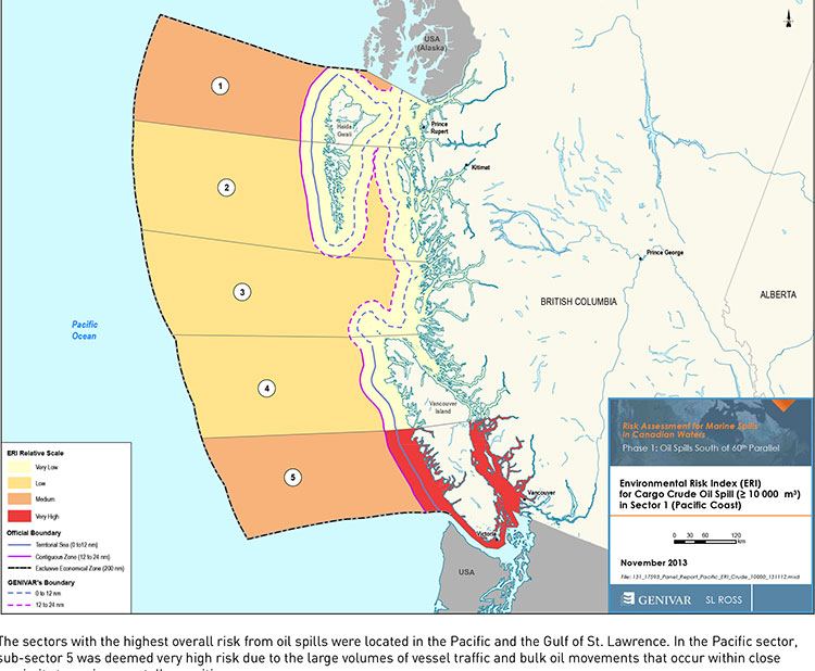
Tanker risk map
Transport Canada tanker report map shows current risk for spills in BC (Transport Canada)


Genivar report
Cover of Genivar tanker report (Transport Canada)


The possible effects of a bitumen spill on Pacific waters were not considered in the oil response preparedness report released last week by the Harper government, the background data study reveals.

The consulting firm that did the study for Transport Canada, Genivar Inc, had no reliable data on the effect of a bitumen tanker disaster—because, so far, there has been no major ocean disaster involving diluted bitumen.

Instead, Genivar, based its findings on potential hazards and response on existing data on crude oil spills.

The Genivar study, however, does warn, that if the Enbridge Northern Gateway project does go ahead,  the spill risk from diluted bitumen carrying tankers in Douglas Channel and along the north Pacific coast will jump from “low” or “medium” to “very high.” If the twinning of the Kinder Morgan pipeline goes ahead, then the risk in Vancouver also jumps to “very high.”

The question of how bitumen might behave in the cold and choppy waters of the North Pacific was hotly debated during the Northern Gateway Joint Review hearings earlier this year. Enbridge Northern Gateway based its position on laboratory studies, studies that were challenged by environmental and First Nations intervenors, pointing both to the unknowns of the ocean environment and the continuing problems Enbridge has in cleaning up the spill in the Kalamazoo River in Michigan.

Genivar tried to base its report to Transport Canada on existing data on oil spills and related hazards. What it found instead is that that there are often gaping holes in the reporting and monitoring of oil spills world wide, especially small and medium sized spills.

Lack of data also meant that Genivar had little to go on when it calculated the effect on an oil spill on key areas of interest to northwest British Columbia, the recreational fishery and tourism.
Genivar, however, did uncover disturbing data about the long term effects of oil spills, studies that show even minute amounts of remaining oil can still disrupt the marine environment 40 years after an event.

The Genivar report, Risk Assessment for Marine Spills in Canadian Waters Phase 1: Oil Spills South of 60th Parallel, was completed in November, then passed on to the “expert panel” that released their own report: A Review of Canada’s Ship-source Oil Spill Preparedness and Response Regime — Setting the Course for the Future. That second report was based not only on the data provided by Genivar but on the expertise of three panel members, their visits to some locations and input from government, industry, First Nations and municipalities.

Transport Minister Lisa Raitt and Natural Resources Minister Joe Oliver unveiled the second report at a glitzy media event  in Vancouver on Tuesday, December 10. At that time the expert panel report was released to the media along with an abstract of the data.

The actual data report was not posted; it had to be requested through the Transport Canada website, which is how Northwest Coast Energy News obtained the background study.

High risk for Kitimat
Transport Canada tanker report
Expert panel tanker risk assessment report cover (Transport Canada)

The expert panel found “a very high risk” of oil spills in two areas of the Pacific Coast, in the north around the ports of Kitimat and Prince Rupert and in the heavy ocean traffic area of southern British Columbia, especially Port Metro Vancouver and into Washington State.

The expert panel made 45 recommendations that covered a wide range of issues including eliminating the present $161-million liability limit for each spill and replacing it with unlimited liability for polluters, annual spill training involving the Canadian Coast Guard, Environment Canada, provincial and local authorities and the private sector, increased and improved annual spill training exercises, basing risk assessment on local geography and conditions and faster emergency responses to spills.

The expert panel calls for greatly increased research on the ocean environment at a time that Harper government has been gutting environmental research across Canada, while spinning that its policies are “science based.”

The science and technology around both the movement of oil and spill response has advanced significantly over the past several decades. We feel that while some aspects of the Regime have kept pace with these developments, in some areas, Canada has fallen behind world-leading countries like Norway and France. This can be attributed to a general lack of investment in research and development as well as the lack of coordination between industry and government over research priorities.

The Government of Canada should work closely with industry to establish a national research and development program for oil spill preparedness and response. The program should be co-funded by industry and the Government, and the research priorities should be set through a collaborative process that involves academia, where possible. Like the Regime itself, we view this program as a partnership between industry and government.

We envision that this program would also seek to leverage the work being done internationally on oil spill preparedness and response. The program should seek to establish partnerships with other world-leading countries in order to stay current on international advances and new technologies.

The expert panel, however, does not say how the federal government is expected to pay for meeting BC Premier Christy Clark’s condition for a “world class” spill prevention and response system at a time that Finance Minister Jim Flaherty is determined to balance the budget and the Harper government is continuing to cut back government services.

Bitumen excluded

On bitumen, the Genivar data study says:

Modified bitumen products represent the majority of the “crude carried as cargo” in
Pacific sub-sector 5. They are not modelled as a separate category in this spill behaviour analysis but are represented as “persistent crude”.

Changes in spill behaviour depend to some extent on the environmental conditions at the time of the spill, as described in greater detail below. However, over the range of wind and sea conditions typically experienced in the Canadian marine environment, changes in oil properties are not overly sensitive to variations in climatic values, so a single set of wind and sea conditions will be used in the analysis.

The idea that “changes in oil properties” not being sensitive to variations in climate was also frequently challenged before the Joint Review Panel.

On the increase in traffic volume if the Northern Gateway project goes ahead, the Genivar report says.

Enbridge Inc. has proposed to construct a marine terminal at Kitimat, B.C. and a dual pipeline from the terminal to oil sands production in northern Alberta. The terminal would handle up to 193,000 barrels/day of imported diluents (i.e., low-gravity condensate) that would be piped to Alberta and used to dilute bitumen to enhance its flow properties. The diluted bitumen would then be piped to Kitimat at rates up to 525,000 barrels/day that would be shipped by tanker to export to markets in Asia and California.

At full capacity, the import of diluent and export of diluted bitumen would total up to 35 Mt/year. This amount is comparable to the currently-shipped volume in the Pacific sector related to volumes being exported from Vancouver and related to volumes being exported from the Alaskan to Washington State trade.

It goes on to say that the current tanker traffic on the north Pacific coast “has negligible risk in the near shore and intermediate zones, but significant potential spill frequency in the deep-sea zone related to the Alaskan trade.” Similarly, according to Genivar the environmental risk in the region “currently ranges from ‘medium’ to “very low” from near shore to deep-sea zones, respectively…. mainly driven by a combination of physical and biological features.”

The increase in traffic from Northern Gateway would likely increase the environmental risks. The the near shore risk from would jump from “very low” to “very high.” For the largest spill category, deep-sea risk would likely increase from “low” to “medium.”

No data on recreational or traditional First Nations fishery

To study the effect on an oil spill on the fishery, Genivar used data from the Department of Fisheries and Oceans as the provinces to gauge “the port value of commercial fishing and the value of the fish, shellfish and aquaculture” in each zone it studied and then compared it to the the national averages for commercial fishery. Those figures included any commercial fishery by First Nations.

But Genivar noted, there is no reliable data on either the recreational fishery or the First Nations traditional, food, social and ceremonial fishery, saying:

It is important to highlight that this indicator does not consider recreational or traditional fishing. The importance of this industry is notable and an oil spill could damage the recreational fishing stock as well. However, the absence of comparable data and the fact that this study is restricted to federal and international data, and some provincial data from Quebec and Ontario for commercial fisheries, limits the ability to include recreational fishing… Nevertheless, as an absolute index, it will provide an overall vulnerability in the event of an oil spill.

The ongoing impact of cutbacks at Fisheries and Oceans has had a continuing impact on the northwest, especially in the controversial halibut recreational fishery, where DFO has admitted that it is basically guessing the size of each year’s recreational halibut catch.

Tourism

Genivar also notes that lack of reliable data on the effect on a oil spill on tourism. The consultants go so far as to say one of the indicators they will use to measure the effect of any oil spill on tourism would come from “data extracted from the 2011 National Household Survey at the census division level and the accommodation and food services data will be used.”

The “National Household Survey” is also known as the long form census and it is the National Household Survey that the Harper government made voluntary rather mandatory, decreasing the reliability of the data. Global News recently analyzed those who had contributed to the survey and found that it poor people, the very rich and people in low population areas were least likely to fill out the voluntary census—which means the data for northwest BC is likely highly unreliable from the 2011 survey even though “The census divisions in coastal regions will be selected for each of the sub-sectors. This method will express the economic vulnerability of each sub-sector to a potential collapse in tourism following a spill.”

Despite the importance of cruise ship traffic on the west coast, Genivar notes, “In Canada, data for passenger vessels were unavailable.”

It also notes that “this study does not specifically take into account national parks and other landmarks, since their influence on tourism is indirectly included in the tourism employment
intensity index” so that Genivar could create what it calls the Human-Use Resource Index (HRI), even though that index appears to be based on incomplete data.
Oil spill dangers can linger for 40 years, report shows

Genivar report
Cover of Genivar tanker report (Transport Canada)

The Genivar report for Transport Canada on oil spills say that some persistent effects can last for more than 40 years, based on a study of a spill in Cape Cod, Massachusetts. The report  notes that persistent sub-surface oil is still a problem at Prince William Sound, site of the Exxon Valdez disaster in 1989.

On long-term effects, Genivar reports: “The ingestion of contaminated food (such as oiled mussels), may represent the most important exposure pathway for aquatic fauna during a chronic
phase. Chronic exposure to contaminated sediments is also important for fauna or
vegetation.”


It goes on to stay that “large-scale oil spills might have considerable long-term
consequences on social structure and public health, interfering with traditions and
causing cultural disruptions.”

It appears that in the case of an oil-spill, time may heal some wounds, but not all of them, at least if time is considered within human lifetimes and the lifetimes of other species.

Ecological recovery is measured by how quickly individuals and populations of
species return to pre-spill conditions. It is determined by factors such as oil type,
exposure duration, water temperature, degree of weathering, spill response and the
individual and species-specific life history traits. In most environmental habitats,
recovery is completed within 2-10 years after a spill event, but in some exceptional
cases, such as in salt marshes, effects may be measurable for decades after the
event.

In the case of the Exxon Valdez oil spill in Prince William Sound… in 1989, the persistence of sub-surface oil in sediments and its chronic exposure continues to affect some of the wildlife through delayed population reductions, indirect effects and trophic interactions 20 years beyond the acute phase of the spill.

It then goes on to stay that

Four decades after the oil spill In Wild Harbor (USA), Spartina alterniflora beds had a reduced stem density and biomass and mussels in oiled locations showed decreased growth and filtration rates.

According to a Boston Globe story, published at the time of the Deepwater Horizon oil leak in the Gulf of Mexico, in 2010, the Wild Harbor, an oil barge ran aground near Cape Cod in September, 1969, spilling 200,000 gallons of fuel, some of which is still there.

The Boston Globe story noted:

Today, Wild Harbor looks much like any other Cape Cod marsh, but the oil below the surface affects its resiliency. Fiddler crabs normally burrow deep down, funneling oxygen to the roots of marsh grass. Here, they stop digging when they reach the oil, turn sideways, and burrow back to the surface. They also act “drunk’’ from the oil they ingest, and predators can catch them more easily, research shows.

The Woods Hole Oceanographic Institute has been studying the Wild Harbor spill for the past 40 years.

At a recent conference, Dr. John Teal updated scientists on the “multi-decadal effects” of the Wild Harbor spill. According a blog on the conference:

At the time of the 1969 spill, lobsters, clams, and fish died by the thousands, but most people believed the harm would be temporary, reflecting the conventional wisdom of the time. Barge owners and oil industry experts even told residents that most of the oil would evaporate and any damage would only be short-lived. However, researchers at WHOI were not so sure and immediately began cataloging species and tracking where the oil was and kept at it for years. The researchers understood that the immediate, short term effects of oil pollution were already obvious and fairly well-understood, but that everyone was rather ignorant about the long-term and low-level effects of an oil spill….

Beginning three to five years after the spill, marsh grasses and marsh animals were again occupying most of the oiled area. An observer unfamiliar with Wild Harbor would not have been able to visually detect the oiled areas after just 10 years, and by the second decade after the spill, the marsh’s appearance had returned to normal. However, the WHOI researchers pointed out that for more than a decade after the spill, an oil sheen still appeared on the surface of the water when mud from the most heavily oiled parts of the marsh was disturbed….

In 2007, WHOI researchers documented that a substantial amount of moderately degraded petroleum still remained within the sediment and along eroding creek banks of the marsh oiled in 1969. They also demonstrated that the ribbed mussels that inhabit the oiled salt marsh, and are exposed to the oil, exhibited slower growth rates, shorter mean shell lengths, lower condition indices, and decreased filtration rates even when placed in a healthy marsh. Researchers have also documented detrimental effects of the 1969 oil spill on the salt marsh plants themselves.


Related Oil Spill on the Wild Harbor Marsh by John M. Teal and Kathryn A. Burns
The Genivar report goes on to note:

Long-term effects on the population in the aquatic environment (especially on mobile fauna) are especially difficult to confirm. Benthic [bottom dwelling] invertebrates may be more at risk than fish species due to the fact that more or less sessile organisms are likely to suffer higher initial rates of mortality and exhibit long recovery times as a result of
exposure to oil-saturated habitats.

Nearshore demersal [bottom-dwelling] fish can also suffer from long-term chronic exposure, as indicated in masked greenlings and crescent gunnels by biomarkers on hydrocarbons 10 years after the Exxon Valdez spill. Mortality in sea ducks and sea turtles due to chronic exposure was also reported many years after the spill and other results indicate that effects on cetacean populations can last beyond 20 years after the acute exposure phase.

As for the recovery of the economy after a spill, Genivar notes it is based “on the time required for effected industries to be fully restored to pre-spill conditions.

The length of time required is influenced by the duration of the aquatic area closures (e.g. commercial fisheries, recreational fisheries), the public perceptions on seafood safety and the perceived effects of the aesthetic quality of the environment. Even after the full ecological recovery of the aquatic resources, fisheries can be far from reestablished, as is still the case for herring fisheries in the Exxon Valdez spill area…

As reviewed by Genivar, negative perceptions associated with the quality of fishery products, even for fisheries that have not been contaminated and also for regions not directly affected by the spill, can be far more important than the direct economic losses. This also holds true for the tourism sector and all other related spinoff sectors.

One of the Kitimat LNG projects plans to self-generate power for liquefaction plant

At least one of the two large liquified natural gas projects in Kitimat is, at least at this point, planning to self-generate the power required using a gas-fired, steam-driven electrical generation system.

A job ad posted this weekend by the headhunting firm Fircroft is seeking a Lead Project Engineer, Power Plant for “Our client, a major international owner/operating company, requires expertise for their LNG mega-project in Western Canada.”

The job, which requires 20 years and more experience, would be located in Calgary for eighteen months, then move to Kitimat for the remainder of a four year contract paying from $1650 to $1850 per day.

By Fircroft describing the job as a “mega-project” means that the client is either Shell’s LNG Canada project or the Chevron and Apache KM LNG project, since the much smaller BC LNG project could not be described as a “mega-project.”

As well as the standard qualifications for a senior engineer, the job posting lists:

• Power Plant design, operation and construction experience required.
• Boiler design, construction, operation, and commissioning experience required.
• Heat Recovery Steam Generation (HRSG) design, processes, construction, operation, and commissioning experience required.
• Integrates inherent safety in design and operability in concept selection and development for gas resource opportunities.

Providing the power for the Kitimat and other northwestern LNG projects is becoming controversial. The power is needed to cool the natural gas so it can be loaded onto tankers for shipment to customers.

The BC government recently announced a $650,000 study of the cumulative effect on air quality for the planned industrial expansion in the Kitimat area, including the Rio Tinto Alcan Kitimat modernization project, which would increase the amount of sulphur dioxide emissions, combined with as many as three LNG projects and the associated increase in tanker traffic, as well as the possible and even more controversial Enbridge Northern Gateway project.

At the time of the BC announcement, the Globe and Mail reported:

If natural gas is used either for direct-drive or combined-cycle electricity generation to produce the energy required for the proposed Shell LNG facility at Kitimat, approximately 300 million cubic feet of natural gas would be burned. The proposed Chevron Apache LNG facility could burn approximately 140 million cubic feet of natural gas.

The other alternative for powering the LNG plants is to use hydro-electricity, and BC Hydro at the moment doesn’t have the capacity to supply the LNG projects with power. One possibility is the controversial Site C dam project in the Peace River basin, which is also under review by the BC government. 

Although the job is restricted to Canadian citizens or permanent residents, it is clear that the engineer will have to also answer to the project’s overseas partners since one requirement is to conduct:  “Overseas VIP workshops, including Value Engineering, Process Simplification, Process Optimization and Design to Capacity.”

Clio Bay remediation project “killing two birds with one stone,” Ross says

Special report: Clio Bay cleanup: Controversial, complicated and costly


Ellis Ross
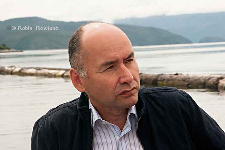
Haisla Nation Chief Counsellor Ellis Ross at Bish Cove, June 19, 2013. (Robin Rowland/Northwest Coast Energy News)

Haisla Chief Counsellor Ellis Ross says that capping the logs at Clio Bay was a Haisla idea, taking advantage of the opportunity to use the marine clay from Bish Cove to bring back the Clio ecosystem.

The Haisla were told by experts who video taped the bottom of Clio Bay that are between 15,000 to 20,000 sunken logs in Clio Bay.

“I know because I’ve spent a lot of time down there plus my dad actually worked for the booming company for years and knew what was going on out there,” Ross said. “There are two extreme areas we’re talking about, if you look at Clio Bay where it’s estimated that there 15,000 to 20,000 logs down there, imagine what Minette Bay looks like? And it’s all iron, it’s steel. It’s not just wood, there are a lot of cables down there.

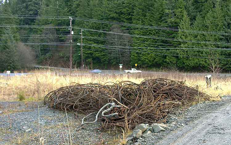
Retrieved cables
Cables retrieved from Ward Cove, Alaska, during dredging and capping in 2001. (EPA)

“The Haisla have known about the degradation of our territory for years. The problem we have as Haisla members is to restore the habitiat is that nobody wants to clean up the habitat. This was our idea, after review from technical experts from DFO as well as our own experts. We’re looking for a three way solution, with the company, DFO and the Crown and the Haisla.”

“I’d love to go and catch halibut and cod, like my ancestors used to.”

He said that the Haisla have beem aware of environmental problems from sunken logs for decades and have been asking for cleanup of degraded areas since 2004, not just at Clio Bay, but in the Kildala Arm and at Collins Bay, which were studied by DFO in 1997.

“The logs are down there, they are oxidizing, but no one wants to do anything about it, including the company and including the Crown. We had independent people come in and review it and have them come up with a recommendation. There was a small scale project [involving marine clay] that proved that this could work.

“This system here is killing two birds with one stone, get rid of the clay and try to remediate some of the habitat,” Ross said.

He said that the original estimate of marine clay excavated at Bish Cove was 10,000 cubic metres. That has now risen to about 3.5 million cubic metres because the KM LNG project is digging deeper for the foundation of the LNG terminal. The original plan called for disposing 1.2 million cubic metres at sea and another 1.2 million cubic metres on land.

“The original idea was to dump the clay in the middle of the ocean. In small amounts it could have been mitigated, but in large amounts we said ‘no.’ If we try to dump clay in the middle of the channel, we have no idea where it’s going to end up, what the effect is going to be.” Ross said. “We did the same thing here for the terrestrial side, we said ‘OK that with the rock quarries above Bees Creek,’ use the clay to help remediate that as well, bring it back.”

Asked about Ward Cove in Alaska, where the US Environmental Protection Agency ordered a cleanup, Ross said. “The difference here is that no one is ordering these companies to clean up the sites, they walk away. No one is taking responsiblity, The Haisla are trying to do this within the parameters they’ve given us.So if someone could come in and order these companies and do something, we’ll look for something else to do with the clay. Until that day comes, the Haisla are still stuck with trying to bring back this land by ourselves. If the District of Kitimat wants to pay the bill, great. Let’s see it.

“We need to put pressure on the province or Canada to cleanup these sites. We’ve been trying to do this for the last 30 years. We got nowhere. Before when we talked about getting those logs and cables cleaned up, it fell on deaf ears [at DFO]. They [DFO] had no policy and no authority to hold these companies accountable. So we’re stuck, we’re stuck between a rock and hard place. How do we fix it?”

Ross also noted that Shell’s LNG Canada project also faces remediation problems, “Shell is going to have the same problem, their’s is going to be different, they’re going to have get rid of contamination on the ocean bottom and beneath that it’s basically going to be gravel, it’s not clay, they’re going to have get rid of that product.”

[rps-include post=5057]

Clio Bay Editorial:Hire the experts. This is not the time to be learning on the job

Special report: Clio Bay cleanup: Controversial, complicated and costly

Editorial:

Hire the experts. This is not the time to be learning on the job.

Everyone in the Kitimat and Kitamaat Village are facing a dilemma, a dilemma that should have been solved a year ago, when it was first known that the KM LNG project at Bish Cove had grossly underestimated the amount of marine clay and other material that has to be removed for the liquified natural gas terminal, a total of about 3.5 million metric tonnes.

The Haisla and Chevron are proposing that much of the clay be deposited over sunken logs in Clio Bay.

Chevron, which only took over operations at KM LNG in December 2012, is still learning on the job.

When the Clio Bay capping plan became public, far too late in the process, only then did Chevron begin to take a serious look public worries about the environmental problems that might result from depositing all that marine clay in Clio Bay.

Chevron hired Stantec, a well-known international  consulting firm with close ties to the energy industry and some experience in remediation to evaluate Clio Bay. Although Chevron said in a statement that Stantec is a company  “with extensive experience in many major habitat restoration projects,” it appears that Stantec, in the case of Clio Bay, is a jack of all environmental trades and master of none, just learning on the job.

In answer to questions by Northwest Coast Energy News, Chevron cited two studies supplied to them by Stantec. One was Chris Picard’s (now with the Gitga’at First Nation) study of Clio Bay which anyone can find by using a Google Search. The second was an overview chapter of west coast North American logging practices from a book published 22 years ago.

Any of the web saavy undergraduate journalism students I once taught at Ryerson University could have done better. This semi-retired reporter, without the resources he once had in a major newsroom, easily found the studies of the log filled Ward Cove, the State of Alaska’s recommended remediation practices, the capping procedures recommended by the US Army Corps of Engineers and more. Chevron did not mention Stantec citing the 1995 DFO study of nearby Minette Bay which can easily be found on the DFO website.

A letter from Fisheries and Oceans to District of Kitimat Council only mentions Dungeness crab and not the Haisla desire to restore halibut and cod to Clio Bay. That can only raise suspicions that the DFO is also depending solely on Chris Picard’s limited survey of Clio Bay.

In Alaska, at Ward Cove, there were almost five years of studies on the ocean environment before part of the cove was dredged and parts of the cove with thousands of logs there were capped with fine sand.

The people of Kitimat and Kitamaat want the LNG project to proceed. Everyone wants a clean and sustainable ocean enviroment, whether in Clio Bay, Minette Bay or down Douglas Channel. The problem of that 3.5 million cubic metres of marine clay must be handled in a timely fashion so the LNG terminal can move to the next step in the coming months. There is no time for five years of studies before proceeding.

This site would not normally endorse one large corporation over another.

There isn’t time for Chevron and Stantec to be learning on the job, its technicians racing in their boats between Clio Bay and Bish Cove trying to figure out what is going on and casually asking people what they think. No time at all.

The clock is ticking. Chevron and Apache, in partnership with both the Haisla and the District of Kitimat, should immediately hire the companies that do have the expertise in remediating a northwest Pacific coast bay filled with sunken logs, the companies that cleaned up Ward Cove in Alaska. Integral Consulting was the main environmental consulting contractor at Ward Cove, assisted by another large firm, Exponent  and by Germano and Associates, a company that  according to its website specializes in “rapid seafloor reconnaissance”. Both Integral and Exponent are, like Stantec, giant international consulting firms.  In this case, experience has to count. While Stantec’s website does list remediation projects, none are similar to Clio Bay.

A letter from Fisheries and Oceans to the District of Kitimat says that:

Chevron will be required to conduct a pre-construction, construction and post construction monitoring program. Pre-construction monitoring will include collection of baseline information that will be used to assess effectiveness monitoring during and at the completion of the project. Water quality monitoring for turbidity and total suspended solids will be undertaken during construction to determine if established performance criteria are met.

From the reports available from both the EPA and the State of Alaska it appears that the companies that cleaned up Ward Cove did just what DFO is asking, assess and monitor.  Another reason to hire the experts rather than the newbies.

Why a three way partnership? Chevron/Apache and the Haisla Nation are already partners in the Clio Bay plan. Adding the District of Kitimat would establish trust and make sure that the results of any scientific and engineering studies, plans and operations would be available to the people of Kitimat (as well as some Haisla members who feel they were excluded) as part of the ongoing process. The partnership would make up for the lack of transparency up until now, make sure the public is kept up-to-date and not just by Chevron’s and DFO’s communications people since reports to the District could be reviewed by the engineering staff and members of council.

It is likely that those companies that worked at Ward Cove could quickly let everyone know whether the idea of capping at Clio Bay with marine clay is a viable option and if it is viable how to do it properly rather than just dumping the clay from a barge using a hose. If marine clay is not viable for Clio Bay, it is likely that those firms could advise whether one of the original plans, to dump the clay in the deep ocean, is a better solution, or if there is another alternative that no one has thought of.

Kitimat and Kitamaat are lucky. The recommended practice for capping sunken logs is using sand. There is here a ready source at the Kitimat Sand Hill. If marine clay is not a viable option, or for future projects, the Sand Hill can easily be used to fulfill the aims of both the Haisla Nation and the residents of Kitimat to clean up Clio Bay, Minette Bay and eventually all 50 other sites identified along Douglas Channel by DFO in 1997. Those consulting firms have the expertise in this area and that expertise should be utilized.

Learning from the job

Even though sand has a track a record in capping, using marine clay from Bish Cove  to cap the logs at Clio Bay is probably a good idea, after all that marine clay was once at the bottom of the Ice Age Douglas Channel.

The use of sand for capping sites is well-known, there are established engineering parameters. At Ward Cove, there were studies of the angle of the slopes and how much weight of sand that the debris could hold.  Sand is very different from marine clay. At the moment, there are no engineering parameters for marine clay. It appears that no one has thought of doing slope analysis and load bearing engineering studies at Clio Bay.

Marine clay is a potential cap for all the sunken log sites on Douglas Channel and on the whole Pacific coast from Oregon to Alaska.  That means that Clio Bay is a pilot project that should be planned as carefully as possible, within the time constraints needed for construction of the LNG terminal, but not regarded as a rush job to get rid of that clay.  That means taking the time needed to do all the necessary scientific and engineering studies before the first drop of clay heads to the bottom. That is another reason to hire experts who actually know what they are doing so everyone can learn from the job.


Standards

No matter how the cleanup of Clio Bay proceeds, KM LNG, the Haisla and the District of Kitimat are facing another dilemma. What standards and benchmarks should be applied to the project?

By law, the Department of Fisheries and Oceans is responsible and will, of course, be monitoring the cleanup.

Despite assurances in a letter to the District of Kitimat, it is clear that DFO too is learning on the job.

At the moment, DFO has no standards for remediation, because the Conservative omnibus bills have gutted environmental standards in Canada. Even before the omnibus bills and the LNG rush, cleaning up log dumps was on the DFO low low priority list.

The letter from DFO to District of Kitimat council shows what knowledgeable sources have told us, DFO will be navigating Clio Bay from a desk in Kamloops (of all places). The same sources say that the Prince Rupert office of DFO, which has the expertise on the northwest coast is out of the loop on this project. The residents of the northwest coast already know there are not enough fisheries officers to properly monitor the coast. DFO “estimates” the annual recreational halibut catch (perhaps by using fish entrails rather than the traditional chicken?). DFO has retired or laid off many scientists who have studied the coast. Others have left on their own. The remaining scientists are muzzled by the Harper government, with anything they could say filtered by the Prime Minister’s Office, so it is likely that no one in the northwest will actually trust what they say.

Normally in a free and democratic society, the government tells local residents when a major operation like the remediation of Clio Bay is going to occur.  In this case, Fisheries and Oceans did not tell anyone in Kitimat anything until the District of Kitimat Council requested information.

On Monday, Sept. 30, a representative of Chevron will make a presentation to District Council. DFO did nothing more than send a letter that said: “Regretfully, Fisheries and Oceans Canada is unable to attend the scheduled council meeting.” Nobody, in the whole department? One is tempted to say, “That’s not good enough.” Then you remember that if DFO appeared before Council, the presenter would have to face possibly awkward questions from both members of Council and the media. That just doesn’t happen in Stephen Harper’s Canada, not in Ottawa and certainly not in Kitimat.

Despite what DFO has said in its letter, this regulatory vacuum leaves the Kitimat region no choice. Since Canada has no standards, when the Clio Bay project proceeds, the best available standards are those set by Alaska, which has the same type of coast and climate. The Clio Bay clean up should therefore be measured against those Alaska standards.
[rps-include post=5057]

Coastal First Nations launch election commercial with Exxon Valdez radio call

Coastal First Nations have launched a commercial aimed at the British Columbia electorate, using the call from the Exxon Valedez to US Coast Guard Valdez traffic control saying that the tanker had run aground.


The commercial makes the connection between the Exxon Valdez disaster and the possibility of a tanker disaster on the British Columbia coast if the Enbridge Northern Gateway project goes ahead.

According to the Vancouver Sun, Paul Simon personally approved the use of the song Sounds of Silence in the commercial.

The BC New Democrats, who are leading the polls have said they oppose Northern Gateway. The ruling BC Liberals have set out five conditions that must be met if the project is to go ahead.

US calls for study that could relax double-hulled oil tanker regulations, citing costs to build, energy consumption

The United States Department of Transportation Maritime Administration has issued a call for a study that is calling into question the future of double-hulled oil tankers.

On August 6, 2012 the Maritime Administration, also known as MARAD, issued a “solicitation” for a study on the Safety, Economic and, Environmental Issues of Double Hulls.

In the call for the study, MARAD says:

Following the Exxon Valdez disaster, the passing of the Oil Pollution Act of 1990 (OPA 90) led to the requirement to replace single hull petroleum tankers with double hull tank vessels sailing in U.S. waters. This requirement was soon adopted by the International Maritime Organization (IMO) and became a worldwide regulation. This means that, today, tank vessels worldwide are carrying thousands of extra tons of steel in order to meet the double hull requirements.

Though these double hulls reduce the threat of oil pollution as a result of grounding, they significantly increase the amount of energy needed to propel a vessel and increase the amount of air pollution into the atmosphere. As a result, the maritime industry’s carbon footprint and criteria pollutant emissions are increased.
In addition to the need to burn more fuel, it is acknowledged that double hulls can cause several other problems which will be detailed in this study.

Here in Canada, Enbridge Northern Gateway and its supporters, in briefings on maritime and tanker safety on the west coast of British Columbia, have always said that the changes following the Exxon Valdez disaster in Prince William Sound and the subsequent US Oil Pollution Act as almost guaranteeing that such a disaster could not happen again.

Now it appears that some people in the U.S. Department of Transportation may be worried that increased use of double-hulled tankers will cost too much. There’s also the apparent question of balancing the carbon footprint of increased emissions from tankers with the danger from a hydrocarbon spill.

The request for the study was covered by tanker industry sites such as Marine Link but only surfaced in major media on Sunday, when The National, an English-language newspaper in Abu Dhabi broke the story, “US maritime agency considers overhaul of oil-spill regulation”

Reporter David Black notes:

In July last year, the IMO adopted binding regulations to limit the expected gas emissions increase by reducing fuel consumption of ships by as much as 15 million tonnes in 2020, a 14 per cent reduction, and by 2050, by as much as 1,013 million tonnes. This will lead to savings in fuel costs for the shipping industry of up to US$200 billion a year, says the IMO.

Black says that the US agency seems “to suggest by abandoning the additional weight of double hulls the savings would increase and pollution be cut further, adding “On the other hand, since the introduction of double hulls, pollution from major oil spills has been reduced to practically zero.”

The National story says even the tanker industry itself is worried about the move, quoting the the international tanker owners’ organization.

“We have noted reports about Marad’s intended study on tanker double hulls but, except for what we gather from press articles, we have little knowledge on the reasoning behind this,” said Bill Box, Intertanko’s senior manager for external relations.
“From our members’ experience, double-hull designs have evolved into safe and reliable ships with an excellent safety and pollution prevention record. We might provide comments when such a study would be released by Marad.”


The requirements for the double-hull study, as posted by the US government are:

1. The Contractor shall conduct an assessment of the history in the evolvement of “The Double Hull Rules”.

2. The Contractor shall conduct the assessment of any rules that are being proposed in bodies such as the IMO, U.S. Congress and other such bodies’ worldwide as they relate to additional hulls for environmental reasons.

3. The Contractor shall assess all the relevant safety issues related to double hulls for each class of vessel. E.g. Double bottoms are difficult and expensive to maintain and can result in corrosion problems. Unchecked corrosion in older double hull vessels can lead to cargo leakage into a double bottom and the buildup of dangerous vapor which could cause an explosion under certain conditions. The Contractor will obtain data from appropriate organizations which details the issues in double bottoms on older vessels including cracking, leakage, and the potential for vapor buildup.

4. The contractor shall conduct a complete economic study of the consequences of Double Hulls. E.g. they significantly add to the construction cost of vessels. They result in the loss of cargo space which also adds to the carbon footprint since an additional vessel(s) is needed to carry the same cargo tonnage.

5. The contractor shall assess the complete consequences of the carbon footprint of designing, constructing, maintaining and operating vessels with double hulls. E.g. Apart from the extra propulsive forces and fuel needed, the carbon footprint of double hull maintenance is substantially increased.

6. The Contractor shall prepare a report on the results of the project. The report shall be grammatically correct and must be professionally written to a high level of competence in the English language. The report must clearly specify the safety, economic and environmental issues details above.


Enbridge files massive river oil spill study with the Joint Review Panel

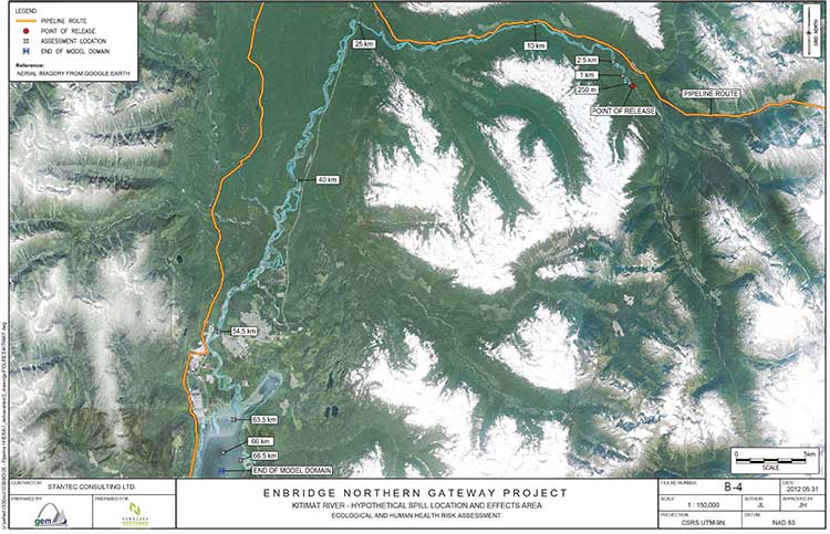
Kitimat River map from Enbridge study
A Google Earth satellite map of the Kitimat River used as part of Enbridge Northern Gateway’s oil spill modelling study.

Enbridge Northern Gateway today filed a massive 11-volume study with the Joint Review Panel outlining possible scenarios for oil spills along the route including the Kitimat and Morice Rivers in British Columbia.

The study, carried out by three consulting firms, Stantec Consuting and AMEC Environmental & Infrastructure both of Calgary and RPS ASA of Rhode Island, is called “Ecological and Human Health Assessment for Pipeline spills.”

Overall the models created by study appear to be extremely optimistic, especially in light of recent events, such as the damning report on by the US
National Transportation Safety Board and the finding of violations by the US Pipeline and Hazardous Material Safety Administration with Enbridge operations during the 2010 Marshall, Michigan, spill and subsequent cleanup difficulties encountered by Enbridge.

The executive summary of the report begins by saying

This document presents conservatively developed assessments of the acute and chronic risk to ecological and human receptors in the unlikely event of a full bore pipeline break on the proposed Enbridge Northern Gateway Pipeline project. Three representative hydrocarbon types (condensate, synthetic oil
and diluted bitumen) were evaluated with releases occurring to four different rivers representing a range of hydrological and geographic characteristics, under both low-flow and high-flow conditions. The analysis indicates that that the potential environmental effects on ecological and human health from each hydrocarbon release scenario could be adverse and may be significant. However, the probability of the releases as considered in the assessment (i.e., full bore rupture, with no containment or oil recovery) is low, with return periods for high consequence watercourses ranging from 2,200 to 24,000 years. Therefore, the significant adverse environmental effects as described in this report are not likely to occur.

So the study says that it is “conservative” that means optimistic, that a full bore pipelink break with no containment or recovery is “an unlikely event” and would probably occur every 2,200 and 24,000 years. Not bad for a pipeline project that is supposed to be operational for just 50 years.

The summary does caution:

The analysis has also shown that the outcomes are highly variable and are subject to a great many factors including the location of the spill, whether the hydrocarbons are released to land or directly to a watercourse, the size of the watercourse, slope and flow volumes, river bed substrate, the amount of suspended particulate in the water, environmental conditions (such as the time of year, temperature and wind speeds, precipitation, etc.), the types of shoreline soils and vegetative cover and most significantly, the type and volume of hydrocarbon released.

The highly technical study is Enbridge’s official response to those intervenors who have “requested additional ecological and human health risk assessment studies pertaining to pipeline spills” and a request from the Joint Review Panle for more information about “the long term effects of pipeline oil spills on aquatic organisms (including the sensitivity of the early life stages of the various salmon species), wildlife, and human health.”

The report presents modelling on the release of three hydrocarbons, diluted bitumen, synthetic oil and condensate at four river locations along the pipeline route for their potential ecological and human health effects, under two flow regimes (i.e., high and low flow), broadly representing summer and winter conditions.

Modelling was done for four areas:

• Chickadee Creek: a low gradient interior river tributary discharging to a large river system
located up-gradient from a populated centre within the Southern Alberta Uplands region
• Crooked River: a low gradient interior river with wetlands, entering a lake system within
the Interior Plateau Region of British Columbia
• Morice River: a high gradient river system along the western boundary of the Interior
Plateau Region of British Columbia
• Kitimat River near Hunter Creek: a high gradient coastal tributary discharging to a large
watercourse with sensitive fisheries resources, downstream human occupation, and discharging to the Kitimat River estuary

In one way, the study also appears to be a partial victory for the Kitimat group Douglas Channel Watch because the model for the Kitimat River is based on a spill at Hunter Creek, which has been the subject of extensive work by the environmental group, but the consulting study is markedly optimistic compared to the scenario painted by Douglas Channel Watch in its presentations to District of Kitimat council.

The study describes the Kitimat River:

The hypothetical release location near Hunter Creek is southwest of Mount Nimbus, in the upper Kitimat  River watershed, and flows into Kitimat River, then Kitimat Arm, approximately 65 km downstream. The area is in a remote location and maintains high wildlife and fisheries values. The pipeline crossing near Hunter Creek is expected to be a horizontal direction drilling (HDD) crossing. The release scenario
assumes a discharge directly into Kitimat River…

The streambed and banks are composed of coarse gravel, cobbles and boulders. Shoreline vegetation (scattered grasses and shrubs) occurs in the channel along the tops of bars. Vegetation is scattered on the channel banks below the seasonal high water mark and more developed (i.e., grasses, shrubs and trees) bove the seasonal high water mark.

Wildlife and fish values for the Kitimat River are high: it is important for salmon stocks, which also provide important forage for grizzly bears, bald eagles and osprey on the central coast. The Kitimat River estuary, at the north end of Kitimat Arm, also provides year-round habitat for some waterbirds and seasonal habitat for staging waterfowl.

There is considerable recreational fishing, both by local people and through fishing guides, on Kitimat River, its estuary and in Kitimat Arm. There is also likely to be a high amount of non-consumptive recreational activity in the area, including wildlife viewing, hiking and camping. The Kitimat River estuary, for example, is well known for waterbird viewing.

While no fish were captured at this location during the habitat survey, salmonoid fry and coho salmon were observed downstream. Previously recorded fish species in the area include chinook, coho and chum salmon, rainbow trout, Dolly Varden, and steelhead trout.

However, the next paragraph appears to show that a full bore rupture on the Kitimat River would have widespread consequences because it would cover a vast area of First Nations traditional territory, saying

Aboriginal groups with traditional territories within the vicinity of the Kitimat River hypothetical spill scenario site include the Haisla Nation, Kitselas First Nation, Kitsumkalum First Nation, Lax-Kw’alaams First Nation and Metlakatla First Nation.

It also acknowledges:

Oral testimony provided by Gitga’at First Nation and Gitxaala Nation was also reviewed in relation to this hypothetical spill scenario, although the traditional territories of these nations are well-removed from the hypothetical spill site.

The report then goes on to list “the continued importance of traditional resources” for the aboriginal people of northwestern BC.

especially marine resources. People hunt, fish, trap and gather foods and plants throughout the area and traditional foods are central to feasting and ceremonial systems. Food is often distributed to Elders or others in the community. Written evidence and oral testimony reported that Coho, sockeye, pink, and spring salmon remain staples for community members. Halibut, eulachon, herring and herring roe,
various species of cod, shellfish, seaweed, and other marine life are also regularly harvested and consumed, as are terrestrial resources, including moose, deer, beaver, muskrat and marten. Eulachon remains an important trade item. Written evidence provides some information on seasonality of use and modes of preparation. Seaweed is dried, packed and bundled and preserved for later use. Each species of
salmon has its own season and salmon and other fish are prepared by drying, smoking, freezing or canning. Salmon are highly valued and often distributed throughout the community…

Some areas used traditionally are not depicted geographically. Upper Kitimat River from the Wedeene River to the headwaters has long been used for trapping, hunting, fishing and gathering of various foods. Fishing, hunting and gathering activities take place along the lower Kitimat River and its tributaries. Marine resources are collected in Kitimat Arm, Douglas Channel, and Gardner Canal. Old village and
harvesting sites are located along the rivers and ocean channels in this vicinity.

Intertidal areas are important and highly sensitive harvesting sites that support a diversity of species. Many intertidal sites are already over harvested and are therefore vulnerable. Conservation of abalone has been undertaken to help the species recover. Some concern was expressed in oral testimony regarding the
potential for archaeological sites and the lack of site inventory in the area. Oral testimony made reference to the Queen of the North sinking and the potential for a similar accident to result in human health and environmental effects.

A spill at Hunter Creek

The model says that all three types of floating oil in Kitimat River under high-flow conditions would reach approximately 40 kilometres downstream from Hunter Creek while low-flow conditions showed variation.

Under what the study calls low flow conditions, most condensate would evaporate. The bitumen would cause “heavy shore-oiling” for the first 10 kilometres, with some oiling up to 40 kilometres downstream.

The most sedimentation would occur for synthetic oil, and the least for condensate. Synthetic oil under both flow conditions would have the largest amounts deposited to the sediments. This is because of the low viscosity of synthetic oil, which allows it to be readily entrained into the water where it may combine with suspended sediments and subsequently settle. Synthetic oil under high-flow conditions would result in the most entrained oil and so the most extensive deposition to the sediment. Diluted bitumen, for both flow conditions, would result in the most deposited on shorelines, with the remainder (except that which evaporated or degraded) depositing to the sediments.
The condensate also would also have significant entrainment, but higher winds prevailing in under low flow conditions would enhance evaporation and rapidly lower concentrations in the water as compared to high-flow conditions. In all scenarios, a large amount of entrained oil and high concentrations of dissolved aromatics would move down the entire stretch of Kitimat River and into Kitimat River estuary.

Long term scenario

The modelling appears to be extremely optimistic when it reaches four to six weeks after the pipeline breach, especially in light of the continued cleanup efforts in Michigan, estimating that the “fast-flowing” nature of the Kitimat River would disipate all the different forms of hydrocarbon in the study saying

 a fast-flowing coastal river like Kitimat River, with gravel or cobble bottom would be affected by a large volume of crude oil released in a short period of time.

Oiling of shoreline soils is heavy in the reaches between the release point and 10 km downstream, becoming lighter to negligible beyond 10 km. Deposition of hydrocarbons to river sediment is greatest for the synthetic oil and diluted bitumen (high flow) scenarios extending up to 40 kilometres downriver, with predicted hydrocarbon concentrations in sediment approaching 1,000 mg/kg dry weight. Deposition of hydrocarbons to river sediment is considerably lighter for the diluted bitumen (low flow) and condensate scenarios. In these scenarios, oiling of river sediment is negligible….

It says that within four weeks of the end of the acute phase of the spill scenarios, concentrations in river sediments and river water would decline becoming quite low at the end of two years.

As for the affects on plants and invertebrates:

Oiling of shorelines would be extensive, particularly at assessment locations within 10 kilometres of the pipeline break location, under both the high and low flow scenarios, for synthetic oil and condensate. High loadings occur as far as 25 kilometres downstream, again asusming that damage would begin to disipate after four weeks declining over the next one to two years. Predicted effects are generally less severe for the diluted bitumen spill scenarios, due to lower expected loading of oil onto shorelines. Low to negligible shoreline oiling would occur for Kitimat River under most of the scenarios at the 40 kilometres assessment location and points downstream. Based on this assessment, very little oiling of shorelines would extend to the estuary and the environmental effects would be minimal.

The study goes on to say that the “model suggests that there would be no significant risk to fish health based upon chronic exposure to petroleum hydrocarbons  for the oil spill scenarios in Kitimat River or the potentially affected areas within the estuary, either at four weeks or one to two years following the hypothetical spill events. Risk to developing fish eggs in Kitimat River and estuary at four weeks and one to two years again indicate no significant risk to developing fish eggs in spawning gravels.”

It also claims that “chronic risks” to wildlife would be minimal, with some elevated risk for “muskrat, belted kingfisher, mallard duck, spotted sandpiper and tree swallow,” if they were exposed to synthetic oil. The muskrat, mallard duck and spotted sandpiper
could be vulnerable to bitumen and diluted bitumen.

It then claims that “no significant effects of chronic exposure (to all hydrocarbons) would occur for grizzly bear, mink, moose, river otter, bald eagle, Canada goose, herring gull or great blue heron for the Kitimat River hydrocarbon spill scenarios.”

Again, it appears from the sutdy that the spotted sandpiper would be most vulnerable to “bulk weathered crude oil exposure” includingcondensate, diluted bitumen and synthetic oil.

For the Kitimat section it concludes:

In the unlikely event of an oil spill, recovery and mitigation as well as the physical
disturbance of habitat along the watercourse would be likely to substantially reduce the exposure of wildlife receptors to hydrocarbons as compared to the scenarios evaluated here.

Link to Volume One of the Enbridge Northern Gateway Report Ecological and Human Health Assessment for Pipeline Spills

Enbridge’s multi-million dollar ad campaign collides on the web with Alberta oil spill and fears about the water supply

As the people near Sundre, Alberta deal with an oil spill of up to 175,000 litres into the Red Deer River, there have been reports on Twitter all day of Enbridge’s pro-pipeline ads appearing alongside stories on the oil spill on news sites across Canada. For most of Saturday,  I didn’t see any Enbridge ads on the news pages I checked. Ad viewing is usually tied by algorithms to the specific viewer’s interests.

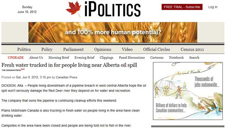
Tonight, an Enbridge ad did show up on my computer screen.  An unfortunate pairing of a CP story on Ipolitics.ca  that  drinking water will be trucked into the affected communities. Alongside it the animated Enbridge ad promoting the Northern Gateway.

Enbridge ad accompanies a story on the Alberta oil spill

Water supply is a critical issue in the Enbridge debate, especially in Kitimat, BC, where the pipeline will cross the Kitimat River watershed and then follow the route of the Kitimat River to the planned terminal at the town’s waterfront. The environmental group Douglas Channel Watch says its studies show that a major rockfall or landslide could cut Kitimat’s water supply for up to four years, meaning the town would have to survive on bottled water for years.  Enbridge has said its studies and engineering will ensure the water supply is safe.

But it get’s worse.   I had written this story and went back to the original Ipolitics.ca story to double check the facts and the URL   The page had automatically refreshed and a new Enbridge ad appeared as a banner ad. In the right-hand box where the previous Enbridge had been a few moments before, there is now an advertisement  promoting the safety of fracking.

Enbridge banner ad on Alberta oil spill story

Advertisers want interested eyeballs and various cookies and tracking mechanisms mean that these days that ads appear either in a story that is tied to the industry, in this case, oil and gas, or  tied to the viewers’ web history.

In all the years I worked in television news, there were always protocols for pulling suddenly and unexpectedly inappropriate ads from a local, network or cable newscast  when there was “breaking news.”

It’s a lot harder to do that for a web ad, but it can be done. It may that with Enbridge spending millions of dollars on ads, management was reluctant to stop the campaign cold.  But ads can e pulled. The fact the ads are running on the second day of the spill raises again the question of Enbridge’s managerial competence. After all, the American Petroleum Institute, the lobby group for the American energy industry, immediately stopped all pro-drilling ads within hours of realizing that the BP spill in the Gulf of Mexico was a major incident.

(Note this site has no control over the Google ads which appear, which are even more than most ads, are tied to Google’s tracking of an individual’s viewing habits as well as the content of the story.  Major banner ads, like Enbridge’s, however, are usually booked through web ad agencies and can be pulled by clicking a mouse.)

And yes, when I checked the facts on the ad campaign, finding a story from May 30, in the Calgary Herald, the Enbridge ad was there as well.

In the story, picked up from the Vancouver Sun,  Enbridge spokesman Paul Stanway was quoted:

“You are going to see a much higher visibility for Enbridge over the next few days. In newspapers, in television and online,” said Paul Stanway, manager of Northern Gateway communications for Enbridge. “It’s become quite apparent that the debate has become a province wide issue.”

Calgary Herald web page with Enbridge ad

Note, due to those algorithms, if you click on the original pages, you may or may not see the Enbridge ads, just I didn’t see the ones earlier today that were linked to from Twitter.

From Pro Publica: North Dakota’s Oil Boom Brings Damage Along With Prosperity

Northwest Coast Energy News is republishing this story  on spills and other waste from the North Dakota shale oil and gas boom from the U.S. investigative site Pro Publica. Of most interest to readers here in northwest BC is ProPublica’s map of the spills in North Dakota, which is linked to in the story but not part of the republication package. You can find the map at this link or in the body of the story. That spill map, of course, could be a model for anyone tracking similar events in British Columbia.

North Dakota’s Oil Boom Brings Damage Along With Prosperity
by Nicholas Kusnetz, Special to ProPublica June 7, 2012

Oil drilling has sparked a frenzied prosperity in Jeff Keller’s formerly quiet corner of western North Dakota in recent years, bringing an infusion of jobs and reviving moribund local businesses.

But Keller, a natural resource manager for the Army Corps of Engineers, has seen a more ominous effect of the boom, too: Oil companies are spilling and dumping drilling waste onto the region’s land and into its waterways with increasing regularity.

Hydraulic fracturing 2014 the controversial process behind the spread of natural gas drilling 2014 is enabling oil companies to reach previously inaccessible reserves in North Dakota, triggering a turnaround not only in the state’s fortunes, but also in domestic energy production. North Dakota now ranks second behind only Texas in oil output nationwide.

The downside is waste 2014 lots of it. Companies produce millions of gallons of salty, chemical-infused wastewater, known as brine, as part of drilling and fracking each well. Drillers are supposed to inject this material thousands of feet underground into disposal wells, but some of it isn’t making it that far.

According to data obtained by ProPublica, oil companies in North Dakota reported more than 1,000 accidental releases of oil, drilling wastewater or other fluids in 2011, about as many as in the previous two years combined. Many more illicit releases went unreported, state regulators acknowledge, when companies dumped truckloads of toxic fluid along the road or drained waste pits illegally.

State officials say most of the releases are small. But in several cases, spills turned out to be far larger than initially thought, totaling millions of gallons. Releases of brine, which is often laced with carcinogenic chemicals and heavy metals, have wiped out aquatic life in streams and wetlands and sterilized farmland. The effects on land can last for years, or even decades.

Compounding such problems, state regulators have often been unable 2014 or unwilling 2014 to compel energy companies to clean up their mess, our reporting showed.

Under North Dakota regulations, the agencies that oversee drilling and water safety can sanction companies that dump or spill waste, but they seldom do: They have issued fewer than 50 disciplinary actions for all types of drilling violations, including spills, over the past three years.

Keller has filed several complaints with the state during this time span after observing trucks dumping wastewater and spotting evidence of a spill in a field near his home. He was rebuffed or ignored every time, he said.

“There’s no enforcement,” said Keller, 50, an avid outdoorsman who has spent his career managing Lake Sakakawea, a reservoir created by damming the Missouri River. “None.”

State officials say they rely on companies to clean up spills voluntarily, and that in most cases, they do. Mark Bohrer, who oversees spill reports for the Department of Mineral Resources, the agency that regulates drilling, said the number of spills is acceptable given the pace of drilling and that he sees little risk of long-term damage.

Kris Roberts, who responds to spills for the Health Department, which protects state waters, agreed, but acknowledged that the state does not have the manpower to prevent or respond to illegal dumping.

“It’s happening often enough that we see it as a significant problem,” he said. “What’s the solution? Catching them. What’s the problem? Catching them.”

Ron Ness, president of the North Dakota Petroleum Council, a lobbying group, said the industry is doing what it can to minimize spills and their impacts.

“You’re going to have spills when you have more activity,” he said. “I would think North Dakotans would say the industry is doing a good job.”

In response to rising environmental concerns related to drilling waste, North Dakota’s legislature passed a handful of new regulations this year, including a rule that bars storing wastewater in open pits.

Still, advocates for landowners say they have seen little will, at either the state or federal level, to impose limits that could slow the pace of drilling.

The Obama administration is facilitating drilling projects on federal land in western North Dakota by expediting environmental reviews. North Dakota’s Gov. Jack Dalrymple has urged energy companies to see his administration as a “faithful and long-term partner.”

“North Dakota’s political leadership is still in the mold where a lot of our oil and gas policy reflects a strong desire to have another oil boom,” said Mark Trechock, who headed the Dakota Resource Council, a landowner group that has pushed for stronger oversight, until his retirement this year. “Well, we got it now.”

Reaching ‘the Crazy Point’

Keller’s office in Williston is as good a spot as any to see the impacts of the oil boom.

The tiny prefab shack 2014 cluttered with mounted fish, piles of antlers and a wolf pelt Keller bought in Alaska 2014 is wedged between a levee that holds back Missouri River floodwaters and a new oil well, topped by a blazing gas flare. Just beyond the oil well sits an intersection where Keller estimates he saw an accident a week during one stretch last year due to increased traffic from drilling.

Keller describes the changes to his hometown in a voice just short of a yell, as if he’s competing with nearby engine noise. Local grocery stores can barely keep shelves stocked and the town movie theater is so crowded it seats people in the aisle, he said. The cost of housing has skyrocketed, with some apartments fetching rents similar to those in New York City.

“With the way it is now,” Keller said, “you’re getting to the crazy point.”

Oil companies are drilling upwards of 200 wells each month in northwestern North Dakota, an area roughly twice the size of New Jersey.

North Dakota is pumping more than 575,000 barrels of oil a day now, more than double what the state produced two years ago. Expanded drilling in the state has helped overall U.S. oil production grow for the first time in a quarter century, stoking hopes for greater energy independence.

It has also reinvigorated North Dakota’s once-stagnant economy. Unemployment sits at 3 percent. The activity has reversed a population decline that began in the mid-1980s, when the last oil boom went bust.

The growth has come at a cost, however. At a conference on oil field infrastructure in October, one executive noted that McKenzie County, which sits in the heart of the oil patch and had a population of 6,360 people in 2010, required nearly $200 million in road repairs.

The number of spill reports, which generally come from the oil companies themselves, nearly doubled from 2010 to 2011. Energy companies report their spills to the Department of Mineral Resources, which shares them with the Health Department. The two agencies work together to investigate incidents.

In December, a stack of reports a quarter-inch thick piled up on Kris Roberts’ desk. He received 34 new cases in the first week of that month alone.

“Is it a big issue?” he said. “Yes, it is.”

The Health Department has added three staffers to handle the influx and the Department of Mineral Resources is increasing its workforce by 30 percent, but Roberts acknowledges they can’t investigate every report.

Even with the new hires, the Department of Mineral Resources still has fewer field inspectors than agencies in other drilling states. Oklahoma, for example, which has comparable drilling activity, has 58 inspectors to North Dakota’s 19.

Of the 1,073 releases reported last year, about 60 percent involved oil and one-third spread brine. In about two-thirds of the cases, material was not contained to the accident site and leaked into the ground or waterways.

But the official data gives only a partial picture, Roberts said, missing an unknown number of unreported incidents.

“One, five, 10, 100? If it didn’t get reported, how do you count them?” he said.

He said truckers often dump their wastewater rather than wait in line at injection wells. The Department of Mineral Resources asks companies how much brine their wells produce and how much they dispose of as waste, but its inspectors don’t audit those numbers. Short of catching someone in the act, there’s no way to stop illegal dumping.

The state also has no real estimate for how much fluid spills out accidentally from tanks, pipes, trucks and other equipment. Companies are supposed to report spill volumes, but officials acknowledge the numbers are often inexact or flat-out wrong. In 40 cases last year, the company responsible didn’t know how much had spilled so it simply listed the volume of fluid as zero.

In one case last July, workers for Petro Harvester, a small, Texas-based oil company, noticed a swath of dead vegetation in a field near one of the company’s saltwater disposal lines. The company reported the spill the next day, estimating that 12,600 gallons of brine had leaked.

When state and county officials came to assess the damage, however, they found evidence of a much larger accident. The leak, which had gone undetected for days or weeks, had sterilized about 24 acres of land. Officials later estimated the spill to be at least 2 million gallons of brine, Roberts said, which would make it the largest ever in the state.

Yet state records still put the volume at 12,600 gallons and Roberts sees no reason to change it.

“It’s almost like rubbing salt in a raw wound,” Roberts said, criticizing efforts to tabulate a number as “bean counting.” Changing a report would not change reality, nor would it help anyone, he added. “If we try to go back and revisit the past over and over and over again, what’s it going to do? Nothing good.”

In a written statement, Petro Harvester said tests showed the spill had not contaminated groundwater and that it would continue monitoring the site for signs of damage. State records show the company hired a contractor to cover the land with 40 truckloads of a chemical that leaches salt from the soil.

Nearly a year later, however, even weeds won’t grow in the area, said Darwin Peterson, who farms the land. While Petro Harvester has promised to compensate him for lost crops, Peterson said he hasn’t heard from the company in months and he doesn’t expect the land to be usable for years. “It’s pretty devastating,” he said.

Little Enforcement

The Department of Mineral Resources and the Health Department have the authority to sanction companies that spill or dump fluids, but they rarely do.

The Department of Mineral Resources has issued just 45 enforcement actions over the last three years. Spokeswoman Alison Ritter could not say how many of those were for spills or releases, as opposed to other drilling violations, or how many resulted in fines.

The Health Department has taken just one action against an oil company in the past three years, citing Continental Resources for oil and brine spills that turned two streams into temporary toxic dumps. The department initially fined Continental $328,500, plus about $14,000 for agency costs. Ultimately, however, the state settled and Continental paid just $35,000 in fines.

The agency has not yet penalized Petro Harvester for the July spill, thought it has issued a notice of violation and could impose a fine in the future, Roberts said, one of several spill-related enforcement actions the agency is considering.

Derrick Braaten, a Bismarck lawyer whose firm represents dozens of farmers and landowner groups, said his clients often get little support from regulators when oil companies damage their property.

State officials step in in the largest cases, he said, but let smaller ones slide. Landowners can sue, but most prefer to take whatever drillers offer rather than taking their chances in court.

“The oil company will say, that’s worth $400 an acre, so here’s $400 for ruining that acre,” Braaten said.

Daryl Peterson, a client of Braaten’s who is not related to Darwin Peterson, said a series of drilling waste releases stretching back 15 years have rendered several acres unusable of the 2,000 or so he farms. The state has not compelled the companies that caused the damage to repair it, he said. Peterson hasn’t wanted to spend the hundreds of thousands of dollars it would take to haul out the dirt and replace it, so the land lies fallow.

“I pay taxes on that land,” he said.

At least 15 North Dakota residents, frustrated with state officials’ inaction, have taken drilling-related complaints to the U.S. Environmental Protection Agency in the last two years, records show.

Last September, for example, a rancher near Williston told the EPA that Brigham Oil and Gas had plowed through the side of a waste pit, sending fluid into the pond his cattle drink from and a nearby creek. When the rancher called Brigham to complain, he said, an employee told him this was “the way they do business.”

A spokeswoman for Statoil, which acquired Brigham, said the company stores only fresh water in open pits, not wastewater, and that “we can’t remember ever having responded in such a manner” to a report about a spill.

Federal officials can offer little relief.

Congress has largely delegated oversight of oil field spills to the states. EPA spokesman Richard Mylott said the agency investigates complaints about releases on federal lands, but refers complaints involving private property to state regulators.

The EPA handed the complaint about Brigham to an official with North Dakota’s Health Department, who said he had already spoken to the company.

“They said this was an isolated occurrence, this is not how they handle frac water and it would not happen again,” the official wrote to the EPA. “As far as we are concerned, this complaint is closed.”

Salting the Earth

Six years ago, a four-inch saltwater pipeline ruptured just outside Linda Monson’s property line, leaking about a million gallons of salty wastewater.

As it cascaded down a hill and into Charbonneau Creek, which cuts through Monson’s pasture, the spill deposited metals and carcinogenic hydrocarbons in the soil. The toxic brew wiped out the creek’s fish, turtles and other life, reaching 15 miles downstream.

After suing Zenergy Inc., the oil company that owns the line, Monson reached a settlement that restricts what she can say about the incident.

“When this first happened, it pretty much consumed my life,” Monson said. “Now I don’t even want to think about it.”

The company has paid a $70,000 fine and committed to cleaning the site, but the case shows how difficult the cleanup can be. When brine leaks into the ground, the sodium binds to the soil, displacing other minerals and inhibiting plants’ ability to absorb nutrients and water. Short of replacing the soil, the best option is to try to speed the natural flushing of the system, which can take decades.

Zenergy has tried both. According to a Department of Mineral Resources report, the company has spent more than $3 million hauling away dirt and pumping out contaminated groundwater 2014 nearly 31 million gallons as of December 2010, the most recent data available.

But more than a dozen acres of Monson’s pasture remain fenced off and out of use. The cattle no longer drink from the creek, which was their main water source. Zenergy dug a well to replace it.

Shallow groundwater in the area remains thousands of times saltier than it should be and continues to leak into the stream and through the ground, contaminating new areas.

There’s little understanding of what long-term impacts hundreds of such releases could be having on western North Dakota’s land and water, said Micah Reuber.

Until last year, Reuber was the environmental contaminant specialist in North Dakota for the federal Fish and Wildlife Service, which oversees wetlands and waterways.

Reuber quit after growing increasingly frustrated with the inadequate resources devoted to the position. Responding to oil field spills was supposed to be a small part of his job, but it came to consume all of his time.

“It didn’t seem like we were keeping pace with it at all,” he said. “It got to be demoralizing.”

Reuber said no agency, federal or state, has the money or staff to study the effects of drilling waste releases in North Dakota. The closest thing is a small ongoing federal study across the border in Montana, where scientists are investigating how decades of oil production have affected the underground water supply for the city of Poplar.

Joanna Thamke, a groundwater specialist with the U.S. Geological Survey in Montana, started mapping contamination from drilling 20 years ago. She estimated it had spread through about 12 square miles of the aquifer, which is the only source of drinking water in the area. Over the years, brine had leaked through old well bores, buried waste pits and aging tanks and pipes.

In the Poplar study and others, Thamke has found that plumes of contaminated groundwater can take decades to dissipate and sometimes move to new areas.

“What we found is the plumes, after two decades, have not gone away,” she said. “They’ve spread out.”

Poplar’s water supply is currently safe to drink, but the EPA has said it will become too salty as the contamination spreads. In March, the agency ordered three oil companies to treat the water or to find another source.

North Dakota officials are quick to point out that oversight and regulations are stronger today than they were when drilling began in the area in the 1950s. One significant difference is that waste pits, where oil companies store and dispose of the rock and debris produced during drilling, are now lined with plastic to prevent leaching into the ground.

New rules, effective April 1, require drillers in North Dakota to divert liquid waste to tanks instead of pits. Until now, drillers could store the liquid in pits for up to a year before pumping it out in order to bury the solids on site. The rule would prevent a repeat of the spring of 2011, when record snowmelt and flooding caused dozens of pits to overflow their banks.

But Reuber worries that the industry and regulators are repeating past mistakes. Not long before he left the Fish and Wildlife Service, he found a set of old slides showing waste pits and spills from decades ago.

“They looked almost exactly like photos I had taken,” he said. “There’s a spill into a creek bottom in the Badlands and it was sitting there with no one cleaning it up and containing it. And yeah, I got a photo like that, too.”

Keller has grown so dispirited by the changes brought by the boom that he is considering retiring after 30 years with the Army Corps and moving away from Williston. He runs a side business in scrap metal that would supplement his pension.

Still, determined to protect the area, he keeps alerting regulators whenever he spots evidence that oil companies have dumped or spilled waste.

Last July, when he saw signs of a spill near his home, Keller notified the Health Department and sent pictures showing a trail of dead grass to an acquaintance at the EPA regional office in Denver. The brown swath led from a well site into a creek.

If the spills continued, he warned the EPA in an email, they could “kill off the entire watershed.”

EPA officials said they spoke with Keller, but did not follow up on the incident beyond that. The state never responded, Keller said. The site remained untested and was never cleaned up.

“There was no restoration work whatsoever,” Keller said.