Clio Bay: Ward Cove, Alaska, benchmark for log remediation

Special report: Clio Bay cleanup: Controversial, complicated and costly

Ward Cove
Ward Cove, Alaska, in 2005, after the remediation of the bay was completed in 2001 and old industrial buildings were being demolished. (EPA)


Ward Cove, just eight kilometres west of Ketchikan, Alaska, was so polluted by effluent from pulp and saw mills and a fish plant, and filled with 16,000 sunken lots that it qualified for a U.S. Environmental Protection Agency Superfund cleanup.

The Ward Cove project is now considered a benchmark for cleaning up similar bays. Alaska officials emphasized to Northwest Coast Energy News, that while Ward Cove does provide guidelines for capping and dredging logs, they were not aware of any project where logs were capped that did not have other forms of contamination.

If you take a look at satellite images of Clio Bay, BC and Ward Cove side by side you immediately you see the similarities and differences between the two bodies of water. (Note due to parameters of Google Earth, images are slightly different scales)

Satellite image of Clio Bay
Google Earth image of Clio Bay
Google Earth image of Ward Cove, Alaska

Both Clio Bay and Ward Cove are 1.6 kilometres long, somewhat elbow shaped, off a main channel and surrounded by mountains.Ward Cove is 0.8 kilometres wide. Clio Bay is about 0.5 kilmetres wide, 0.8 at its widest point. Both have steep slopes from the mountains. Ward Cove is 61 metres deep at the mouth of the cove, descreasing toward the head. Clio Bay is deeper, 182 metres at the mouth, 90 metres in the centre and between 20 metres and 9 metres at the head.

Both Clio Bay and Ward Cove are subject to tidal circulation. Both Clio Bay and Ward Cove are also influenced by fresh water. Ward Cove is fed by Ward Creek, a smaller Walsh Creek and runoff precipitation the enters the cover from the steep mountain slopes. Clio Bay is fed by one creek, a number of small streams and mountain slope runoff, especially during the spring melt.

Haisla Chief Counsellor Ellis Ross estimates there are between 10,000 and 20,000 sunken logs in Clio Bay. The official summary from the United States Environmental Protection Agency said there were 16,000 sunken logs in Ward Cove.

The major difference with Ward Cove is that it was the site of major industrial development including a pulp mill, a sawmill and a fish plant. That meant the level of pollutants in Ward Cove were much higher than in Clio Bay, which has never been used for an industrial plant. It was the pollutants in Ward Cove, mainly ammonia, hydrogen sulfide, and 4-methylphenol combined with the thousands of sunken logs that made the cove a target cleanup and the associated studies.

A fish plant, Wards Cove Packing opened in 1912 and ceased operations in 2002. The Ketchikan Paper Company mill began operating in 1954 and closed in 1997. Prior to 1971, with the rise of the enviromental movement no permits were required by KPC for discharging effluent into the cove. After that the US Environmental Protection Agency issued a discharge permit and monitored effluent. Throughout the time the KPC mill was operating, the EPA says, “high volumes of log storage (approximately 7 billion board feet) caused accumulation of bark waste and sunken logs at the bottom of the cove.” Gateway Forest Products, a sawmill and veneer plant, continued to store logs in Wards Cove until 2002.

A 2009 monitoring report, conducted by the US Army Corps of Engineers after the cleanup for the EPA noted:

An ecological risk assessment was also conducted using a food-web assessment to estimate risks of bioaccumulative chemicals to representative birds and mammals at the top of the Ward Cove food web. The chemicals evaluated were arsenic, cadmium, mercury, zinc, chlorinated dioxins/furans, and PAHs. The results of this assessment indicated that there are no unacceptable risks to higher trophic level organisms in Ward Cove.

A human health risk assessment was conducted to identify potential risks posed by chemicals detected in sediments or seafood (e.g., fish, shellfish). Ingestion of seafood that may contain chemicals bioaccumulated from the sediments was identified as the only complete exposure pathway for humans. The chemicals that were evaluated included: arsenic, cadmium, mercury, zinc, phenol, 4-methylphenol, chlorinated dioxins/furans, and PAHs. Results concluded that sediments in Ward Cove do not pose an unacceptable risk to human health.

A 2007 report on the Wards Cove remediation from the Alaska Department of Environmental Conservation, noted:

The continuing residues impairment in Ward Cove is caused by the historical accumulation of wood waste on the bottom of the cove. The waste includes an estimated 16,000 sunken logs over at least 75 percent of the bottom and decomposing pulp, wood, and bark waste in sediments in thicknesses up to 10 feet over at least 50 percent of the bottom. Wood waste residues can displace and smother organisms, alter habitat, release leachates, create anoxic conditions, and produce toxic substances, all of which may adversely affect organisms that live both on top of sediments and within sediments.

That is a similar problem to Clio Bay.

The report notes that problems with oxygen increase with depth, noting:

The dissolved oxygen impairment was due largely to the fish-processing waste discharge from the seafood processing facility until 2002, and it was limited to the summer months in deeper waters of the cove (below the picnocline, or stratification layer, approximately 10 meters deep). With that discharge removed, limited monitoring in August and September 2003 indicated that dissolved oxygen impairment might remain near the bottom in waters at depths of 30 meters and greater at certain times and locations due to low natural levels of dissolved oxygen and the continuing decomposition of wood waste. Above 30 meters depth, the waters of the cove appeared to meet the [Alaska state] standard for dissolved oxygen. However, there may be limited capacity for waters at 30 meters and deeper to receive additional loading of oxygen-demanding materials and still meet the standard in summer months.

That should mean that the worries about oxygen depletion at Clio Bay are justified due to Clio’s greater depth.

Studies of the biology of Ward Cove began in 1951, with more in the 1960s and one in 1974. In 1995, Ketchikan Paper Company signed a consent decree with the EPA that called for remediation of Ward Cove, In 2000, KPC and Gateway Forest Products signed a second consent decree with the EPA. Those agreements called on the companies to dredge sediments to improve navigation, remove logs and other debris from the dredging areas and “placing a thin-layer cap of 15-30 cm (six to 12 inches) of sand over about 11 hectares (27 acres) of sunken logs.”

The major studies of Ward Cove began in 1995 after first consent decree. The remediation did not take place until the initial studies were complete in 1999, with dredging and capping taking place from November 2000 to March 2001.

The EPA positioned 13 water quality monitoring stations which operated from 1997 to 2002, to measure salinity, temperature and disolved oxygen, nine inside Ward Cove and four outside the cove in Tongass Narrows. Those studies showed that levels of dissolved oxygen in the cove varied by season, depth and location. Many species from salmon to mobile bottom dwellers like crabs were often able to detect and avoid low oxygen areas.

The plan

The EPA and the companies involved planned the remediation so that it included both dredging, capping logs and sediment and leaving some areas where nature would take its course.

The reports say that complete dredging, removal and disposal of the contamination would have cost $200 million,  The total actual cost of the Ward Cove Remediation Project, beginning with development of the Remedial Design Work Plan, was estimated to have cost $3,964,000 (in 2000 US dollars).

The EPA says cost for the capping component of the project “including preliminary field investigations and reporting, design and plans development, post construction engineering, procurement, construction management, project management, mobilizationm demobilization, engineering/QC and science support, surveys, and capping items” was $2,563,506. Based on the volume of capping material placed, the unit cost of log capping for the Ward Cove Remediation Project was $110 per cubic yard.

Sunken logs retrieved at Ward Cove.
Old logs retrieved from Ward Cove, Alaska during dredging operations to improve navigation. (EPA)

The plan called for dredging about 17,050 cubic yards in the area near the cove’s main dock and the dredging of 3,500 yards metres nearby to improved navigation. Before the dredging, 680 tonnes of sunken logs had to be removed. After dredging, a “thin-layer cap of clean, sandy material” was placed in dredged areas unless native sediments or bedrock was reached during dredging.

In other areas, most covered in sunken logs, the plan called for placement of a thin-layer cap (approximately 6- to 12-inches) of clean, sandy material, with the possibility of “mounding” dropping mounds of sand on specific areas. The 2009 report says the area of sand deposits actually increased “due to the fact that thin layer placement was found to be successful over a broader area, and it was not necessary to construct mounding.”

The plan called for natural recovery in areas where neither capping nor mounding was practicable and so about 50 acres was left alone. (DFO says it plans to leave some parts of Clio Bay uncapped as “reference areas.”)
Slope and sand
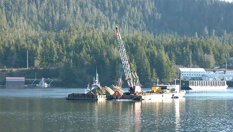
Sand capping at Ward Cove
A dredging barge depositing clean sand (originally from Sechelt, BC) during capping operations at Ward Cove, Alaska in 2001. (EPA)

Two studies were carried out as part of the remediation at Ward Cove that do not appear to be contemplated at Clio Bay. The first looked at the “ability of the organic material to support the weight of 15 to 30 centimetres of sand.” Standard engineering equations used at other fill and capping sites were used as part of that study. A second study was carried out to determine the “minimum safety for a given slope,” which given the steep mountains that line Clio Bay, are likely to be factor in the deposit of marine clay. That study determined “For a silty fine sand and a factor of safety of 1.5, the maximum slope would be approximately 40 per cent.”

Those studies led to the conclusion that for the Ward Cove remediation project, the material to be placed on the fine organic sediment could not be gravel and course sand.”

That’s because the larger gravel and course sand “would tend to sink into the sediment and would not provide quality benethic (seabottom) habitat.”

The project decided to use “fine to medium sand with minimal fines.” It also concluded “Because of the very soft existing sediments and steep slopes at Ward Cove, the … material must be released slowly so that the settling velocity is low and bed impact minimized.”

That meant that the EPA had look for a source of quality sand that met their criterion. The sand was found at Construction Aggregates in Sechelt, BC, loaded on 10,000 tonne deck barges, tugged up the coast, unloaded onto land using a conveyor and stockpiled while more tests were done to determine how to deposit the sand on the sunken logs.

Sand bucket at Ward Cove
Dredging bucket modified to deposit sand during capping operations at Ward Cove, Alaska. (EPA)

Sand was placed on a smaller barge and taken to the deposit site. Initial tests were done with a mechanical dredge equipped with a clamshell bucket. The operator deposited the sand using “swaths” released from the bucket. To make it work properly, the bucket, as supplied by a manufacturer had to be modified by welding baffle plates to the bucket and lengthening the chains to insure consistent deposition of the sand. Two computers with special software called WINOPS, designed for dredging operations  “provided the operator and deck engineer the precise locations of the derrick barge position” in order to ensure precise deposition of the sand. WINOPS dredge positioning and guidance software. The WINOPS system made use of three differential global positioning receivers. One GPS receiver was located at the top of the derrick and provided the center positioning of the dredge bucket. Two fixed receivers, one near the starboard center spud and one near the center aft, provided the barge position and heading.

Although using marine clay is likely to produce different engineering challenges at Clio Bay, it is not currently clear that the project has contemplated the level of precision that was used at Ward Cove.

While KM LNG must find a way to dispose of the marine clay from the Bish Cove excavation site, there is a silver lining for the Haisla Nation’s aim of restoring both Clio Bay and the other 50 sites in their traditional territory, since the Kitimat Sand Hill would likely be a ready resource for any future projects.
Monitoring

The EPA considered the project finished in September 2001, and long term monitoring began, with major updates every five years in 2004 and 2009.

An EPA report on the 2004 review showed that the three sand-capped areas and one shallow natural recovery area (not sand-capped) had achieved biological recovery; three other natural recovery areas tested had not achieved biological recovery but were making significant progress.

The  2004 studies showed that benethic (sea bottom) communities in uncapped areas showed “species commonly found in areas where organic enrichment is low or declining.” adding “In three other natural recovery areas, benthic communities have not progressed as far toward recovery but are making significant progress.

By the time of the 2009 update, most of the old industrial infrastucture on land at Ward Cove had been demolished and the land area was slated for redevelopment. Many of the companies that had been there had either gone out of business or had declared bankruptcy and the land was taken over by the Ketchikan Gateway Borough,mostly through foreclosure.

The EPA declared that “The remedial action construction is complete, and the remedial action is an operating or ongoing remedial action.”

The 2009 report says that the project was successful in eliminating sediment toxicity. The area was then quickly being recolonized by a diverse bottom dwelling macroinvertebrate species and those species were spreading beyond the specific study areas, so recovery of Ward Cove is expected to continue.

However the 2004 report went on to say that “the achievement of stable benthic biological communities with balanced species composition in more than 75 percent of the area with documented coverage by wood residues on the bottom of Ward Cove” would happen within 40 years from the 2004 study.

The next review of Ward Cove is slated for August 2015.


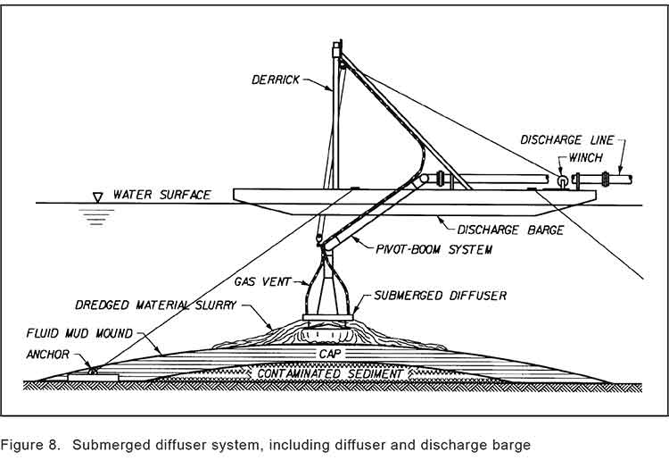
Sand capping
Diagram of a sand capping operation from a barge. (US Army Corps of Engineers)


Diagram of a sediment capping operation knowing as diffusion (US Army Corps of Engineers)


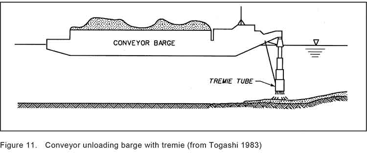
Termie
Diagram of a Japanese system called tremie that uses a hose system to deposit capping material on the seabed. (US Army Corps of Engineers)

[rps-include post=5057]

Clio Bay: What happens to sunken logs?

Special report: Clio Bay cleanup: Controversial, complicated and costly

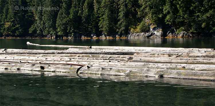
Logs at Clio Bay
Floating logs at Clio Bay, September 14, 2013. (Robin Rowland/Northwest Coast Energy News)

The forest industry has been operating on the Pacific coast from Oregon to Alaska for more than a century. Over that time, it is likely that millions of logs from booms and other operations have sunk to the bottom of bays, cove, estuaries and inlets along the coast.

During that century, scientists in both Canada and the United States have been studying the effects of the those sunken logs on the sea bottom. It is only in recent years that the cumulative effect of all those logs has become an environmental concern.

As well as logs on the sea bottom, ranging, depending on location, from a couple of hundred to the tens of thousands of logs, there are wood chips, wood fibre and discarded log parts and bark. Often metal cables, bolts, ropes, and other manufactured material either dropped accidentally or deliberately discarded are also found among the old logs, further contaminating the seabed. Compounding the problem of the sea bottom is organic material that would occur naturally on the seabed, including tree trunks, roots, branches, conifer needles, deciduous leaves and other material from terrestrial plants.

Anyone who sails Douglas Channel after a storm can see with all the floating tree trunks in the Channe. That means that storms and spring run off ads debris to the natural pile up of old logs and debris. At logging sites, this natural material, brought in by creeks and rivers, piles up on the already sunken logs.

Over the years, depending on the salinity, teredos, more popularly known as ship worms  eat the wood, often leaving a tube of bark that eventually collapses. The rotting wood, bark and other material is often, depending on conditions, pounded into fragments by the action of waves, currents and outflow from rivers. Some species of teredo can live in brackish water, but since teredos are not a fresh water species, that means that logs in fresh or mostly fresh water last longer.

A DFO report on sunken log sites on Douglas Channel, published in 2000, noted:

very few comprehensive, quantitative field studies describing the effects of wood and bark have been published and those that did focused on log handling and storage sites which handled high volumes of more than one million cubic metres.

The DFO report said that thick bark and wood debris deposits resulting from log handling can cause substantial, long-term negative impacts to benthic (sea bottom) ecosystems. Under the worst conditions, the cumulative debris can deprive an area of oxygen and, according to DFO, “virtually eliminate aerobic” sea bottom animal life.

The report noted that studies had shown that “negative biological impacts were localized,” but added that “the cumulative effect of several hundred sites located on the B.C. coast is currently unknown.”

Studying the problem has been a low priority for DFO and other agencies and that meant a limited budget and few studies. Other problems is that, according to the DFO, parts of BC fjords are steep and “much of the likely impacted habitat is beyond diver range.” There is also pressure to study the effect on “economically or socially important species.” Although the use of remotely operated vehicles has increased since the 2000 report, using an ROV can also be a budget buster for a low priority project.

As the ready timber supply in British Columbia particularly old growth forest declined in the last part of the twentieth century, the DFO report says “forest companies have harvested areas where access is more difficult and cut-blocks are smaller.” That meant many smaller dump sites were developed that were used for only one to five years. Plans for log handling at the time, DFO said, were evolving to ensure ensure that fisheries resources and overall fish production capability were not adversely affected by development of log handling facilities and planning was focused on ensuring that sites for log handling facilities did “not have sensitive fish habitats or fisheries resources (such as eel grass beds or shellfish resources) which may be affected by the log handling,”

One of the reasons for the disagreements over Clio Bay is that while some people call it “dead” saying there are no halibut and fewer cod, others say that Clio Bay is very much alive, pointing out that it is easy to catch crab and rock cod.

The studies that have looked at life on the bottom of log dumps sites have shown that it can be highly variable even within one bay or cove, with many factors creating small local ecosystems, including depth, nature of the sea bottom, for example sand, mud, clay or a mixture, whether or not the sea bottom sediment is “enriched,” the flow of currents, fresh water flow into the site, the percentage of wood on the bottom, the percentage of bark on the bottom, whether the wood and/or bark debris is “continuous’ or “discontinuous,” whether or not the seabed is contaminated as was the case with the cleanup of pulp mill sites at Ward Cove and Sitka, Alaska.

Ward Cove had been so polluted for decades by pulp mill effluent that it was eligible for US Superfund clean up funding and was estimated to hold 16,000 sunken logs. At the same time, an EPA report on Ward Cove noted that at the point Ward Creek emptied into Ward Cove was “a popular sport fishing location during salmon season, including commercially guided fishing. Some sport fishing and personal-use crab pot fishing has taken place in the past and may continue in the waters of the cove.” At the same time of the cleanup, the EPA identified that the degradation of Ward Cove put at risk eight species of salmon, 75 “non-salmonid esturine and marine fish species and benthic invertebrate fauna.”  (The EPA says Ward Cove is recovering after the reclamation and fishing is continuing)

In other words, those say Clio Bay is in danger and those who say Clio Bay is a rich source of life are likely both right.

For example, while Chris Picard’s (then with the University of Victoria, now with the Gitga’at First Nation) study of Clio Bay said: “Dungeness crabs were observed five times more often in the unimpacted Eagle Bay than in Clio Bay,” and tied that to log dumping and low oxygen.
Picard’s study noted that both Dungeness crabs and sunflower seastars, while more abundant in Eagle Bay, in Clio Bay “both species were several-fold less abundant in wood-dominated habitats in Clio Bay than in non-wood habitats in that bay.”

Several people have pointed out that since Clio Bay is one of the closest crabbing spots to both Kitimat and Kitamaat Village, while Eagle Bay is further down Douglas Channel, overfishing at Clio may be a factor in the reported species decline.

The DFO study noted

The dumping of logs into water down skids can result in the generation of a considerable amount of bark and wood debris. The abrasive action of boom boats and waves during the sorting and storage of bundles can also generate quantities of wood debris. Bark and wood lost during dumping often forms thick, continuous, anoxic fibre mats extended from the base of the dump skids. The debris mat tends to dissipate with distance from the entry point; however, wood debris can often be observed substantial.” distances from the dump skids as seen at all four of the sites sampled. Debris deposits can also be generated as logs resting on the sea floor decay. Wood boring organisms (e.g., Toredo) quickly reduce the wood fibre content of logs, but the bark of some species (e.g., western red cedar (Thuja plicata) which has a high lignin content) is left relatively untouched. The amount of wood debris generated during handling and storage can be different depending on tree species, tidal levels, and dumping methods. Debris accumulation, distribution, and the resulting biological impacts are affected by physical factors including depth, sea floor slope, dump site aspect, water currents, and wind or wave exposure.

One of the main problems with log dumping is that it has the potential to deplete vital oxygen, especially at deeper levels. Seasonal variations can mean that, even if there are thousands of logs at the bottom, the levels of dissolved oxygen can vary. Years of studies at the cleanup site at Ward Cove, Alaska showed how the oxygen levels can vary by season. In Minette Bay, near Kitimat, a DFO study showed that the Minette is somewhat stagnant and therefore has naturally occurring low oxygen levels, but also that the low levels usually last from May to November and are worst in July.

The DFO study went on to say that oxygen poor thick anoxic bark or wood fibre deposits are likely to cause damage to bottom dwelling species, although in the short term, logs may not cause any impacts. It says that some studies have indicated that large pieces of wood debris can, for a time, increase diversity by providing suitable base for some filter feeders as well as food and cover for epifauna and wood boring organisms. Several species not normally found in sand-bed have occasionally been found in log and rock debris.

(Studies have shown that salmon the ability to detect low oxygen areas and avoid them and some active  invertebrate species can migrate away from a low oxygen area.)

In the long term, logs do decay and the wood and bark left behind can contribute to the wood debris accumulation. One study cited by the DFO survey of Douglas Channel found found that crabs avoided bark deposits when given a choice but when they were forced to live among bark deposits, they were had fewer offspring, had lower feeding rates, and had a decreased survivorship.

One theory is that the decaying organic material produces hydrogen sulphide in combination with ammonia and other unmeasured toxicants. One study of Dungeness crabs, living at a log dump in southeast Alaska with elevated hydrogen sulphide and ammonia concentrations in the bark debris, shows the colony had less than half as many reproducing females as a control population.

The EPA and Alaska reports from Ward Cove show that sand capping does help restore the seabed environment.
[rps-include post=5057]

Clio Bay: DFO declines invitation to appear before Kitimat Council

Special report: Clio Bay cleanup: Controversial, complicated and costly

DFO logoThe Department of Fisheries and Oceans has declined an invitation from District of Kitimat Council to appear at a special meeting on Monday, September 30 to discuss the Clio Bay remediation project.  A representative of Chevron will be in the council chambers at the Kitimat branch of Northwest Community College to make a presentation and answer questions.

The letter from DFO to the council  from Dave Pehl works at DFO office in Kamloops says:

Thank you for the invitation to attend District of Kitimat Council meeting on September 30, 2013 to address plans by Chevron Canada and Apache Canada(Kitimat LNG) to remediate habitat conditions in Clio Bay. Regretfully, Fisheries and Oceans Canada (DFO) is unable to attend the scheduled council meeting.

Fisheries and Oceans Canada has reviewed a proposal to dispose of soil materials, generated at the Kitimat LNG plant, in Clio Bay, Clio Bay has been used as a log handling site for decades which has resulted in areas of degraded habitat from accumulations of woody debris materials on the sea floor. The project intends to cap impacted areas with inert materials and restore soft substrate seafloor. The remediation of the seafloor is predicted to enhance natural biodiverstiy and improve the productivity of the local fishery for Dungeness crab. The project area does support a variety of life that will be impact and therefore the project will require authorization from Fisheries and Oceans Canada for the Harmful Alteration, Disruption or Destruction (HADD) of fish and fish habitat.

Mapping of the seafloor in Clio Bay has been completed and the project plans prioritizes capping on areas of dense woody debris, followed by areas of soft substrate with woody debris distributed throughout. Mapped areas that are avoided include hard substrates and sensitive habitats such as freshwater streams and eelgrass beds. Buffers have been allocated around sensitive areas and no capping will be conducted in areas of less 10m in depth. Proposed mitigation to avoid potential impacts to areas outside Clio Bay includes avoiding deposition of material within 500m of the confluence of Clio Bay and kitimat Arm. Some areas of degraded or partially degraded habitat will not be capped to serve as reference areas.

Chevron will be required to conduct a pre-construction, construction and post construction monitoring program. Pre-construction monitoring will include collection of baseline information that will be used to assess effectiveness monitoring during and at the completion of the project. Water quality monitoring for turbidity and total suspended solids will be undertaken during construction to determine if established performance criteria are met. The monitoring plan for the project will evaluate

1. Water quality near the sea floor.
2. Fish habitat quality and quantity
3. Biodiversity of the seafloor ecosystem and
4. Distribution of a fishery resource (Dungeness crab)

Reference sites will be used to make comparison between capped and uncapped habitats. Monitoring will continue for a period of five years following the completion of the works. The proponent will be required to report the follow-up monitoring program to DFO in years 1,3 and 5 following construction.

[rps-include post=5057]

Clio Bay Editorial:Hire the experts. This is not the time to be learning on the job

Special report: Clio Bay cleanup: Controversial, complicated and costly

Editorial:

Hire the experts. This is not the time to be learning on the job.

Everyone in the Kitimat and Kitamaat Village are facing a dilemma, a dilemma that should have been solved a year ago, when it was first known that the KM LNG project at Bish Cove had grossly underestimated the amount of marine clay and other material that has to be removed for the liquified natural gas terminal, a total of about 3.5 million metric tonnes.

The Haisla and Chevron are proposing that much of the clay be deposited over sunken logs in Clio Bay.

Chevron, which only took over operations at KM LNG in December 2012, is still learning on the job.

When the Clio Bay capping plan became public, far too late in the process, only then did Chevron begin to take a serious look public worries about the environmental problems that might result from depositing all that marine clay in Clio Bay.

Chevron hired Stantec, a well-known international  consulting firm with close ties to the energy industry and some experience in remediation to evaluate Clio Bay. Although Chevron said in a statement that Stantec is a company  “with extensive experience in many major habitat restoration projects,” it appears that Stantec, in the case of Clio Bay, is a jack of all environmental trades and master of none, just learning on the job.

In answer to questions by Northwest Coast Energy News, Chevron cited two studies supplied to them by Stantec. One was Chris Picard’s (now with the Gitga’at First Nation) study of Clio Bay which anyone can find by using a Google Search. The second was an overview chapter of west coast North American logging practices from a book published 22 years ago.

Any of the web saavy undergraduate journalism students I once taught at Ryerson University could have done better. This semi-retired reporter, without the resources he once had in a major newsroom, easily found the studies of the log filled Ward Cove, the State of Alaska’s recommended remediation practices, the capping procedures recommended by the US Army Corps of Engineers and more. Chevron did not mention Stantec citing the 1995 DFO study of nearby Minette Bay which can easily be found on the DFO website.

A letter from Fisheries and Oceans to District of Kitimat Council only mentions Dungeness crab and not the Haisla desire to restore halibut and cod to Clio Bay. That can only raise suspicions that the DFO is also depending solely on Chris Picard’s limited survey of Clio Bay.

In Alaska, at Ward Cove, there were almost five years of studies on the ocean environment before part of the cove was dredged and parts of the cove with thousands of logs there were capped with fine sand.

The people of Kitimat and Kitamaat want the LNG project to proceed. Everyone wants a clean and sustainable ocean enviroment, whether in Clio Bay, Minette Bay or down Douglas Channel. The problem of that 3.5 million cubic metres of marine clay must be handled in a timely fashion so the LNG terminal can move to the next step in the coming months. There is no time for five years of studies before proceeding.

This site would not normally endorse one large corporation over another.

There isn’t time for Chevron and Stantec to be learning on the job, its technicians racing in their boats between Clio Bay and Bish Cove trying to figure out what is going on and casually asking people what they think. No time at all.

The clock is ticking. Chevron and Apache, in partnership with both the Haisla and the District of Kitimat, should immediately hire the companies that do have the expertise in remediating a northwest Pacific coast bay filled with sunken logs, the companies that cleaned up Ward Cove in Alaska. Integral Consulting was the main environmental consulting contractor at Ward Cove, assisted by another large firm, Exponent  and by Germano and Associates, a company that  according to its website specializes in “rapid seafloor reconnaissance”. Both Integral and Exponent are, like Stantec, giant international consulting firms.  In this case, experience has to count. While Stantec’s website does list remediation projects, none are similar to Clio Bay.

A letter from Fisheries and Oceans to the District of Kitimat says that:

Chevron will be required to conduct a pre-construction, construction and post construction monitoring program. Pre-construction monitoring will include collection of baseline information that will be used to assess effectiveness monitoring during and at the completion of the project. Water quality monitoring for turbidity and total suspended solids will be undertaken during construction to determine if established performance criteria are met.

From the reports available from both the EPA and the State of Alaska it appears that the companies that cleaned up Ward Cove did just what DFO is asking, assess and monitor.  Another reason to hire the experts rather than the newbies.

Why a three way partnership? Chevron/Apache and the Haisla Nation are already partners in the Clio Bay plan. Adding the District of Kitimat would establish trust and make sure that the results of any scientific and engineering studies, plans and operations would be available to the people of Kitimat (as well as some Haisla members who feel they were excluded) as part of the ongoing process. The partnership would make up for the lack of transparency up until now, make sure the public is kept up-to-date and not just by Chevron’s and DFO’s communications people since reports to the District could be reviewed by the engineering staff and members of council.

It is likely that those companies that worked at Ward Cove could quickly let everyone know whether the idea of capping at Clio Bay with marine clay is a viable option and if it is viable how to do it properly rather than just dumping the clay from a barge using a hose. If marine clay is not viable for Clio Bay, it is likely that those firms could advise whether one of the original plans, to dump the clay in the deep ocean, is a better solution, or if there is another alternative that no one has thought of.

Kitimat and Kitamaat are lucky. The recommended practice for capping sunken logs is using sand. There is here a ready source at the Kitimat Sand Hill. If marine clay is not a viable option, or for future projects, the Sand Hill can easily be used to fulfill the aims of both the Haisla Nation and the residents of Kitimat to clean up Clio Bay, Minette Bay and eventually all 50 other sites identified along Douglas Channel by DFO in 1997. Those consulting firms have the expertise in this area and that expertise should be utilized.

Learning from the job

Even though sand has a track a record in capping, using marine clay from Bish Cove  to cap the logs at Clio Bay is probably a good idea, after all that marine clay was once at the bottom of the Ice Age Douglas Channel.

The use of sand for capping sites is well-known, there are established engineering parameters. At Ward Cove, there were studies of the angle of the slopes and how much weight of sand that the debris could hold.  Sand is very different from marine clay. At the moment, there are no engineering parameters for marine clay. It appears that no one has thought of doing slope analysis and load bearing engineering studies at Clio Bay.

Marine clay is a potential cap for all the sunken log sites on Douglas Channel and on the whole Pacific coast from Oregon to Alaska.  That means that Clio Bay is a pilot project that should be planned as carefully as possible, within the time constraints needed for construction of the LNG terminal, but not regarded as a rush job to get rid of that clay.  That means taking the time needed to do all the necessary scientific and engineering studies before the first drop of clay heads to the bottom. That is another reason to hire experts who actually know what they are doing so everyone can learn from the job.


Standards

No matter how the cleanup of Clio Bay proceeds, KM LNG, the Haisla and the District of Kitimat are facing another dilemma. What standards and benchmarks should be applied to the project?

By law, the Department of Fisheries and Oceans is responsible and will, of course, be monitoring the cleanup.

Despite assurances in a letter to the District of Kitimat, it is clear that DFO too is learning on the job.

At the moment, DFO has no standards for remediation, because the Conservative omnibus bills have gutted environmental standards in Canada. Even before the omnibus bills and the LNG rush, cleaning up log dumps was on the DFO low low priority list.

The letter from DFO to District of Kitimat council shows what knowledgeable sources have told us, DFO will be navigating Clio Bay from a desk in Kamloops (of all places). The same sources say that the Prince Rupert office of DFO, which has the expertise on the northwest coast is out of the loop on this project. The residents of the northwest coast already know there are not enough fisheries officers to properly monitor the coast. DFO “estimates” the annual recreational halibut catch (perhaps by using fish entrails rather than the traditional chicken?). DFO has retired or laid off many scientists who have studied the coast. Others have left on their own. The remaining scientists are muzzled by the Harper government, with anything they could say filtered by the Prime Minister’s Office, so it is likely that no one in the northwest will actually trust what they say.

Normally in a free and democratic society, the government tells local residents when a major operation like the remediation of Clio Bay is going to occur.  In this case, Fisheries and Oceans did not tell anyone in Kitimat anything until the District of Kitimat Council requested information.

On Monday, Sept. 30, a representative of Chevron will make a presentation to District Council. DFO did nothing more than send a letter that said: “Regretfully, Fisheries and Oceans Canada is unable to attend the scheduled council meeting.” Nobody, in the whole department? One is tempted to say, “That’s not good enough.” Then you remember that if DFO appeared before Council, the presenter would have to face possibly awkward questions from both members of Council and the media. That just doesn’t happen in Stephen Harper’s Canada, not in Ottawa and certainly not in Kitimat.

Despite what DFO has said in its letter, this regulatory vacuum leaves the Kitimat region no choice. Since Canada has no standards, when the Clio Bay project proceeds, the best available standards are those set by Alaska, which has the same type of coast and climate. The Clio Bay clean up should therefore be measured against those Alaska standards.
[rps-include post=5057]

Clio Bay: Links and Documents

Links and documents relating to sunken logs and site remediation

Note many, not all, external links are to pdf files.

Canada

DFO study of sunken log sites in Douglas Channel

DFO Study Dissolved oxygen cycle in Minette Bay

Impact of Wood debris in British Columbia estuaries

Chris Picard’s study of Clio and Eagle Bays as posted on the University of Laval website

United States

Links

Alaska Department of Environmental Conservation

Environmental Protection Agency

Ketchikan Paper Company
This is the EPA Web site on the Ward Cove cleanup and remediation with numerous documents.

EPA capping guidance
EPA contaminated sediment capping guidance

US Army Corps of Engineers

US Army Corps of Engineers capping guidance

Documents

Alaska log site remediation guide  (pdf)

EPA study of dissolved oxygen in Ward Cove (pdf)

Marine Log Transfer Facilities and Wood Waste (pdf)

Academic paper by Ward Cove consultants Geramano & Associates on sediments in Ward Cove and Thorne  Bay, Alaska.

Ward Cove Sediment Remediation Project Revisited

Academic paper by Ward Cove consultants Integral Consulting


 Other Links

Kitimat LNG (KM LNG)

Stantec

Stantec remediation project page

Integral Consulting

Integral Consulting Ward Cove web page

Exponent 

Exponent Ward Cove web page

Exponent LNG Safety web page

Germano & Associates

(Note not all documents used in this report are available online. Some sent to NWCEN are too large to upload)


[rps-include post=5057]

Coastal First Nations launch election commercial with Exxon Valdez radio call

Coastal First Nations have launched a commercial aimed at the British Columbia electorate, using the call from the Exxon Valedez to US Coast Guard Valdez traffic control saying that the tanker had run aground.


The commercial makes the connection between the Exxon Valdez disaster and the possibility of a tanker disaster on the British Columbia coast if the Enbridge Northern Gateway project goes ahead.

According to the Vancouver Sun, Paul Simon personally approved the use of the song Sounds of Silence in the commercial.

The BC New Democrats, who are leading the polls have said they oppose Northern Gateway. The ruling BC Liberals have set out five conditions that must be met if the project is to go ahead.

Four energy giants update multi-billion dollar Alaska LNG development plans

Energy company logos

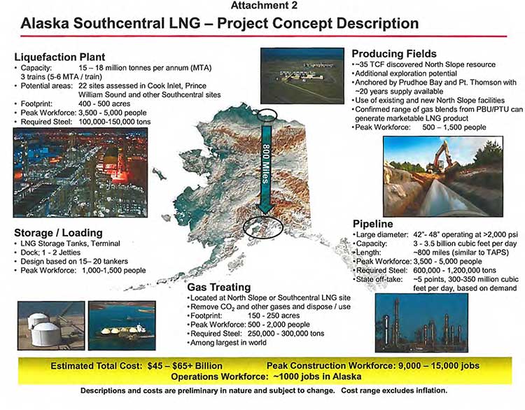
An alliance of four energy companies has updated plans for a multi-billion dollar, ten-year liquefied natural gas megaproject that would take gas from Alaska’s North Slope for shipment to Asia through the oil port at Valdez.

Three of the companies, Exxon Mobile, ConocoPhillips and BP already have operations on the North Slope. TransCanada,which is already planning to build a gas pipeline for the Kitimat Shell project, would be the fourth partner and also work on the pipeline.

Map of Alaska LNG project The four companies filed a letter on October 1 with Alaska Governor Sean Parnell outlining the plans, The governor’s office released the letter today.

The companies told Gov. Parnell that their efforts would result in “a megaproject of unprecedented scale and challenge; up to 1.7 million tons of steel, a peak construction workforce of up to 15,000, a permanent workforce of over 1,000 in Alaska, and an estimated total cost in today’s dollars of $45 to $65+ billion.”


Related:Alaska governor meets with three energy CEOs to push North Slope LNG exports to Asia

The letter goes on to say that TransCanada’s recently completed non-binding solicitation of
interest in the project and that company “has publicly reported interest from potential shippers and major players from a broad range of industry sectors and geographic locations.” (An expression of interest, of course, doesn’t mean that buyers will actually sign contracts, as the Kitimat LNG partners are finding out)

It appears from the letter that the North Slope producers are, in the long term, worried about diminishing oil reserves and are now, like energy companies around the world, looking at cashing in on the natural gas boom.

This opportunity is challenged by its cost, scale, long project lead times, and reliance upon interdependent oil and gas operations with declining production. The facilities currently used for producing oil need to be available over the long-term for producing the associated gas for an LNG project. For these reasons, a healthy, long-term oil business, underpinned by a competitive fiscal framework and LNG project fiscal terms that also address AGIA issues [an Alaska state agency], is required to monetize North Slope natural gas resources. The producers look forward to working with the State to secure fiscal terms necessary to support the unprecedented commitments required for a project of this scope and magnitude and bring the benefits of North Slope gas development to Alaska.

Over the past few months, the partners have, according to the letter:

•Developing a design basis for the pipeline, including areas of continuous and discontinuous permafrost
•Investigating multiple ways to remove and dispose of CO2 and other contaminants
•Assessing use of existing and addition of new Prudhoe Bay field facilities
•Mapping multiple pipeline routing variations
•Assessing multiple pipeline sizes
•Providing for at least five in-state gas off-take points
•Completing preliminary geohazard and marine analysis of 22 LNG site locations
•Developing a design basis for the required LNG tanker fleet
•Evaluating multiple LNG process design alternatives
•Confirming a range of gas blends from the Prudhoe Bay and Point Thomson fields can generate a marketable LNG product

The letter concludes:

Our next steps are to complete the concept selection phase and work with the State to make meaningful progress on the items detailed above. This work is critical as we consider decisions to progress the next phases of an LNG development project.

Alaska’s North Slope natural gas resources must compete in the global energy markets in order to deliver state revenues, in-state energy supplies, new job opportunities and other economic benefits to Alaskans. While North Slope gas commercialization is challenging, working together, we can maintain the momentum toward our shared vision for Alaska. We will continue to keep you advised of our progress and stand committed to work with the State to responsibly develop its considerable resources.

Alaska LNG fact sheet
A fact sheet on the Alaska LNG project sent to the state governor by the project partners.


LNG partners letter to Alaska governor  (PDF)

Avian malaria found in Alaskan birds, another indication of climate change

A form of malaria that infects birds has been found in parts of Alaska, and scientists say the discovery is another indication of climate change in the north.

Common redpollThe spread could prove devastating to arctic bird species that have never encountered the disease and thus have no resistance to it, said San Francisco State University Associate Professor of Biology Ravinder Sehgal, one of the study’s co-authors. The study was published Wednesday, Sept. 19, 2012 in the journal PloS One.

The avian malaria parasite is related to the human form and so the bird study could help scientists track how climate change is affecting human malaria.

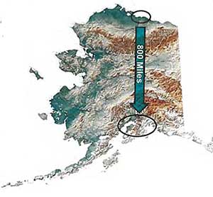
Researchers examined blood samples from both resident and migratory birds collected at four sites from 61°N to 67°N, with Anchorage as a southern point, Denali and Fairbanks as middle points. Coldfoot was the northern point, roughly 960 kilometres north of Anchorage. They found infected birds in Anchorage and Fairbanks as far north as 64°N, but not in Coldfoot

In migratory birds, samples were taken from both adults and hatchlings to see if the infection had occurred locally or during migration.

The study notes that the infected birds at 64°N were above the Arctic Circle commonly known to people across the region as “north of 60”)

Using satellite imagery and other data, researchers were able to predict how environments will change due to global warming — and where malaria parasites will be able to survive in the future. They found that by 2080, the disease will have spread north to Coldfoot and beyond.

“Right now, there’s no avian malaria above latitude 64 degrees, but in the future, with global warming, that will certainly change,” Sehgal said. The northerly spread is alarming, he added, because there are species in the North American arctic that have never been exposed to the disease and may be highly susceptible to it.

“For example, penguins in zoos die when they get malaria, because far southern birds have not been exposed to malaria and thus have not developed any resistance to it,” he said. “There are birds in the north, such as snowy owls or gyrfalcons, that could experience the same thing.”

Researchers are still unsure how the disease is being spread in Alaska and are currently collecting additional data to determine which mosquito species are transmitting the Plasmodium parasites that cause malaria.

The data may also indicate if and how malaria in humans will spread northward.

Modern medicine makes it difficult to track the natural spread of the disease, Sehgal said, but monitoring birds may provide clues as to how global climate change may effect the spread of human malaria.

The study is the fact that the malaria parasites were able to complete their transmission cycle in the North American Arctic” provides “empirical evidence that local hosts in the north of Alaska may be exposed to new parasites with impending global warming,” especially if there is increased variation of both day/night and season temperature changes. Rainfall is also a factor.

Both Anchorage and Fairbanks are likely to have suitable conditions for the avian malaria parasite “completion, other areas with high annual precipitation but mild precipitation and temperature seasonality would be predicted to also be suitable” for the parasite.

One form of the avian malaria parasite has been previously in four bird species: the Common Rosefinch (Carpodacus erythrinus) in South Korea, the Greater Scaup (Aythya marila), the Pacific Golden Plover (Pluvialis fulva) and the Common Yellowthroat (Geothlypis trichas) in the United States, and in six migratory species, meaning that form can tolerate cold temperatures.

The book Birds of British Columbia says the Greater Scaup is a common migrant on the BC coast and may winter in BC, and an abundant migrant in the BC interior in both spring and fall, and often winters in the Okanagan.  The Pacific Golden Plover is rare in BC, because its migration route takes it toward the east coast.  It is usually spotted in the Peace River region but has been seen occasionally near Massett and Boundary Bay. The Common Yellowthroat can be found through the BC mainland in the summer but is rare on Vancouver Island and Haida Gwaii.

A study in New Brunswick has shown that one form of mosquito that tolerates cold infects birds in that province. Although that mosquito is “rare” in Alaska, a close relative is common in the state and although the scientists were unable to find the source of the infection, that Alaskan mosquito could be a prime suspect.


Tiny amounts of copper in rivers endanger salmon by affecting sense of smell

Tiny amounts of copper in a river affect a salmon’s sense of smell, making it harder to avoid predators, according to a study at Washington State University.

Jenifer McIntyre says the copper means that a salmon can’t detect another compound that ordinarily alerts them to be still and wary.

The minute amounts of copper can come from mines and even the brake linings of cars.

“A copper-exposed fish is not getting the information it needs to make good decisions,” says McIntyre, a postdoctoral research associate in WSU’s Puyallup Research and Extension Center, whose study built on earlier work that showed that copper can affect a salmon’s sense of smell and thus changing its behavour.

McIntyre put the two together, exposing juvenile coho salmon to varying amounts of copper and placing them in tanks with cutthroat trout, a common predator.

Healthy salmon can smell compounds in the water that are released when another fish is damaged. That substance, called Schreckstoff, German meaning “scary stuff,” alerts fish to nearby predators.

In her experiments, conducted in a four-foot-diameter tank, fish that weren’t exposed to copper would freeze in the presence of Schreckstoff, making it harder for motion-sensitive predators to detect them. On average, half a minute would go by before they were attacked.

But salmon in water with just five parts of copper per billion failed to detect the Schreckstoff and kept swimming. They were attacked in about five seconds.

“It’s very simply and obviously because predators can see them more easily,” says McIntyre. “They’re not in lockdown mode.”

The unwary exposed fish were also more likely to be killed in the attack, being captured 30 percent of the time on the first strike. Unexposed fish managed to escape the first strike nearly nine times out of ten, most likely because they were already wary and poised to take evasive action.

McIntyre also noticed that the behavior of predators was the same whether or not they had been exposed to copper.

Copper finds its way into streams and marine waters from a variety of sources, including motor vehicle brake linings, pesticides, building materials and protective boat coatings. Actual amounts will vary from undetectable in rural or forested areas to elevated in urban areas, especially when runoff from a storm washes roads of accumulated brake dust and other contaminants.

With testimony from McIntyre’s NOAA colleagues and others, the Washington State legislature in 2010 started phasing out copper brake pads and linings over the next 15 to 20 years. According to the state Department of Ecology, brake pads are the source of up to half the copper in the state’s urban waterways.

McIntyre used concentrations of between 5 and 20 parts per billion but has sampled highway runoff with 60 times as much copper. Copper’s effect is mediated by organic matter, which can make the metal unavailable to living things.

“My scenarios are potentially more like a hard-rock copper mining situation than storm water runoff, which typically carries dissolved organic matter along with the copper and other contaminants,” McIntyre says.

A number of large copper mining projects are proposed for the northwest region including, the controversial Taseko’s Prosperity copper mine near Williams Lake which was stopped after the local First Nations and environmental groups opposed the use of one lake for a tailings pond. Taseko is now trying to revive the project. There area also a number of copper mine proposals for the both the northwest BC coast and the Sacred Headwaters region, source of the major salmon rivers, the Skeena, Nass and Stikine. There is also a proposed copper mine Pebble Mine, at Bristol Bay, Alaska, another prime area for sockeye salmon.

Environmental impact of the Canadian copper mine projects are likely to be affected by the provisions of Bill C-38 which speed up environmental assessment and essentially gut habitat protection for fisheries.

Her research, conducted for a University of Washington doctorate with colleagues at UW and the National Oceanic and Atmospheric Administration, appears in the latest issue of the journal Ecological Applications.

Scientists identify major Japanese-style tsunami hazard for west coast

American scientists studying the aftermath of the March 11, 2011, Tohoku, Japan earthquake and the resulting devastating tsunami say that a similar tsunami could be generated by an earthquake in the Aleutian Islands of Alaska.

The 9.0 magnitude Tohoku earthquake created a tsunami that was a high as 10-metres. The events killed about 18,000 people. Debris from the tsunami is now appearing on the west coast of North America.

The study, published May 8, in EOS, the Transactions of the American Geophysical Society, says:

A tsunami triggered by an earthquake along the AASZ [Alaskan-Aleutian Subduction Zone] would cross the Pacific Ocean and cause extensive damage along highly populated U.S. coasts, with ports being particularly vulnerable.

A subduction zone is where one tectonic plate, in this case, the Pacific plate, is forced down under another plate, the Alaskan continental arc.

Data from the Tohoku earthquake suggests that portions of the Alaskan-Aleutian Subduction Zone could be just as hazardous.

The study, by Holly Ryan, of the Pacific Coastal and Marine Science Center of the US Geological Survey in Menlo Park, Ca. and colleagues says the Japanese earthquake surprised scientists because the magnitude of both the earthquake and the tsunami were much larger than expected for the Tohoku region off northeastern Japan. The scientists say the region was originally considered low risk because the deep water section of the tectonic plate boundary that ruptured had been aseismic [a fault where there are no records of earthquakes] prior to the March 2011 event and was thought to be too weak to accumulate the strain to trigger a major earthquake.

In Japan and the Aleutians, there are seldom records of earthquakes where the upper tectonic plate is made up of weak, water-laden trench sediment accreted [stuck or locked] to the margin along thrust faults. The accreted sediment is not strong enough to fail in an earthquake (stick-slip behaviour) but, rather usually deforms without causing an earthquake.

Now research from the Japan shows that deep water section of the Tohoku region was fully
locked (accumulating strain at the convergence rate). The continental basement rock lies within
20 kilometres of the trench in deep water above the boundary at Tohoku. That created major accumulation of strain on the fault.

So when the earthquake occurred, there were large amounts of slip on the Tohoku megathrust, as well as corresponding movement on a deep water branch fault. Both contributed to the displacement of large volumes of water, creating the giant Japanese tsunami that smashed into the coast.

The Alaskan-Aleutian Subduction Zone is similar to the Tohoku region. The AASZ begins at a deep trench where the Pacific plate under thrusts the Alaskan continental arc and the Aleutian Islands oceanic arc.

Part of that subduction zone triggered the March 27, 1964 Good Friday magnitude 9.2 Anchorage, Alaska, megathrust earthquake. It was the largest quake ever recorded in North America and the second largest worldwide since seismic events were recorded. The epicentre was about 20 kilometres north of Prince William Sound, where a fault ruptured 25 kilometres below the surface. That quake causing major damage in Anchorage, 125 kilometres to the west and in Valdez 64 kilometres to the east. The megathursts along the ocean floor shifts created large tsunamis as high as 67 metres that struck along the North American coast from Alaska to California.

In Anchorage, nine people were killed by the quake, much of the downtown was destroyed and one neighbourhood lost 75 homes in a massive landslide. Two villages near Anchorage were destroyed when the land sank.

According to Wikipedia, the damage to British Columbia alone was estimated at $10 million in 1964 dollars (about $75 million in 2012 dollars according to the Bank of Canada inflation calculator) The Anchorage quake actually shook Kitimat and caused minor damage in the town. Due to factors such as the location of the quake at Prince William Sound , the tides and other factors along Douglas Channel, the tsunami coming into Kitimat was just a few centimetres high. Across the northwest and down the coast, there was more damage, the tsunami that hit Prince Rupert was 1.4 metres. Again to the configuration of the coast, tides and other factors, Port Alberni on Vancouver Island was hit twice, washing away 55 homes and damaging 375 others.

In California, 12 people were killed at Crescent City. There was damage in Los Angeles and as far off as Hawaii.

The study says that an Anchorage type event occurs every 900 years, so that area appears to be out of immediate danger,

According to the study, there was a magnitude 8.6 earthquake near Uninmak Pass in the same region in 1946 that triggered a tsunami that caused damage along the west coast, killed 150 people in Hawaii and inundated shorelines on South Pacific Islands and as far away as Antarctica. Another earthquake near the Andreanof Islands in 1957 also triggered a dangerous tsunami.

The new danger zone could be at the Semidi Islands, southwest of the better known Kodiak Island, where a 400 kilometre-long section of the subduction zone ruptured in 1938, causing a 8.2 magnitude earthquake. In the 1938 earthquake, the study says, that quake was beneath relatively shallow water, so it generated only a modest tsunami.

The Semidi Islands area is now fully locked, the study says, and enough strain has built up to trigger a similar event.

In 1788, a major earthquake in the Semidi Islands was recorded by Russian settlers. It is that area that the study says could trigger a Tohoku type tsunami. The segment of the trench in deeper water has not had a rupture since 1788. Satellite observations show that strain along the fault is accumulating “at a high rate.” The trench is four to five kilometres deep, just like at Tohoku, so displacement of the ocean water could trigger a similar giant tsunami.

Potential rupture of the near-trench section of the plate boundary is worrisome in that similar to the plate boundary near Tohoku, it is composed of rigid basement rock that extends beneath the margin to water depths of four to five kilometres. The presence of rigid basement rock close to the trench allows for an earthquake source beneath deep water, which would significantly amplify the height of the resultant tsunami. In addition, the possible additional rupture of an as yet undiscovered splay or branch fault, similar to circumstances during the Tohoku earthquake, would further increase the tsunami height.

The authors of the study call for more studies to compare the Aleutian area with the Tohoku region of Japan. Scientists are now working on “Paleotsunami studies” so there is a a history of tsunamis generated in the Aleutians that can be correlated to specific earthquakes.

Most of the attention on the west coast of North America has been centred on the Cascadia fault from northern California to southern British Columbia, which could also trigger a major earthquake and tsunami. It is time that scientists, emergency planners and government paid more attention to Alaska.

Link to Study Tsunami Hazards to U.S.  Coasts form Giant Earthquakes in Alaska  (pdf)


View Larger Map

What about the Northern Gateway?

My family was just sitting down for dinner in Kitimat on that Good Friday evening in 1964 when the whole house began to shake. The quake in Anchorage lasted for four minutes, the shock that hit Kitimat was probably less than a minute.

After dinner, tuning to the local TV station, CFTK, the Friday night broadcasts was interrupted by a news special, an extraordinary even for a small station, which in those days had no microwave communications with the rest of the television universe, with the local anchor telling the story based on wire service and other reports that were already trickling in, giving the people of the Kitimat-Terrace-Prince Rupert region the news of the devastation in Alaska.

Fast forward 48 years and the big question on the northwest coast is the Enbridge Northern Gateway pipeline and whether or not the pipeline and the terminals in Kitimat harbour are vulnerable to earthquake and tsunami.

In public presentations in Kitimat, Enbridge officials have always minimized the potential danger to the Northern Gateway from earthquake and tsunami. In its latest presentation, to District of Kitimat Council on April 16, 2012, Enbridge engineer Drum Cavers told council that “all of the major earthquakes have occurred well off shore on the Queen Charlotte Fault,” and that “seismic activity is low relative to south coastal BC.” Cavers also said “the Kitsumcalum-Kitimat Valley is not the site of unusual seismic events or faults.” The presentation points to an 1973 quake in the Skeena River valley that Enbridge says was small and the planned pipeline is within “seismic design parameters.”

Cavers’ presentation said “No fault breaks to surface are known near the pipeline route, but if one should be found during further work, there are methods to mitigate fault motion if required.”

There has been no mention by Enbridge Northern Gateway of the potential problems that could be caused to the Kitimat pipeline and the terminal by a major earthquake or tsunami from the Alaska Aleutian region.

I was out of town during Cavers’ presentation but I have asked questions about the 1964 quake and potential problems from Alaska at three public meetings, including a direct question to Northern Gateway president John Carruthers at the September, 2011, public forum at Kitimat’s Mount Elizabeth Theatre. Despite promises, Enbridge has so far not responded to my questions.